Bridge Statistics for Glendale, Arizona (AZ)
Condition, Traffic, Stress, Structural Evaluation, Project Costs
- National Bridge Inventory (NBI) Statistics
- 141Number of bridges
- 1,860ft / 567mTotal length
- $211,000Total costs
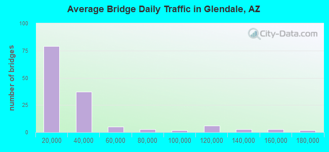
- 3,871,220Total average daily traffic
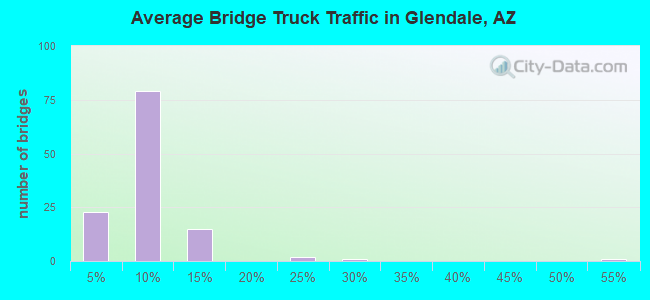
- 247,006Total average daily truck traffic
- National Bridge Inventory (NBI) Registered Bridges for Glendale
- No street view available for this location
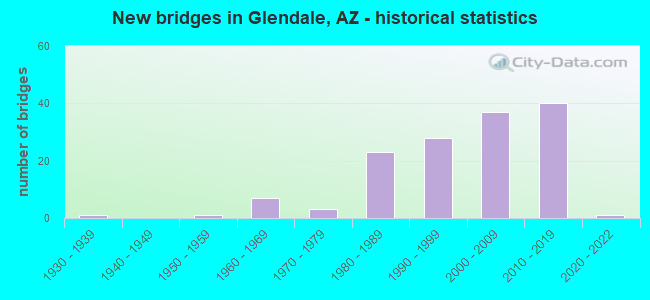
- New bridges - historical statistics
- 11930-1939
- 11950-1959
- 71960-1969
- 31970-1979
- 231980-1989
- 281990-1999
- 372000-2009
- 402010-2019
- 12020-2022
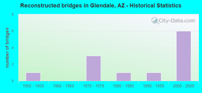
- Reconstructed bridges - Historical Statistics
- 11950-1959
- 01960-1969
- 31970-1979
- 11980-1989
- 11990-1999
- 62000-2009
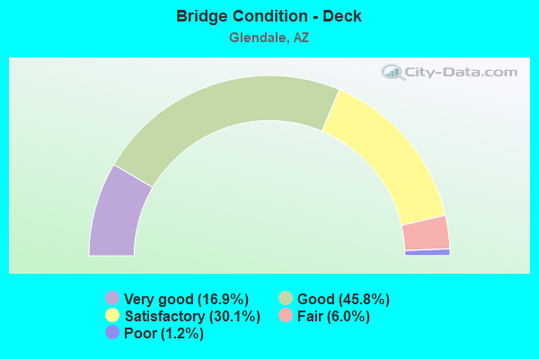
- Bridge Condition - Deck
- 16.9%Very good
- 45.8%Good
- 30.1%Satisfactory
- 6.0%Fair
- 1.2%Poor
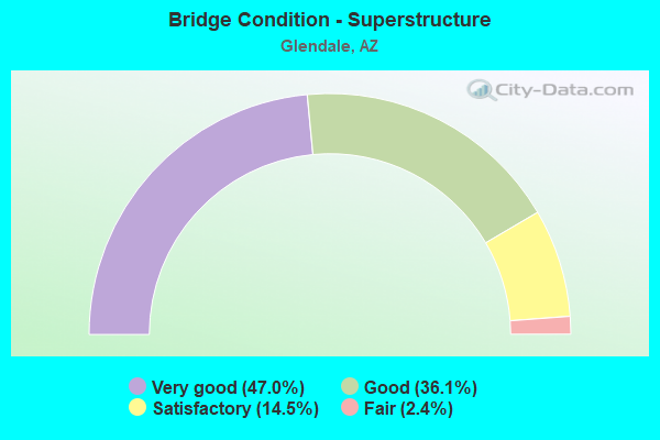
- Bridge Condition - Superstructure
- 47.0%Very good
- 36.1%Good
- 14.5%Satisfactory
- 2.4%Fair
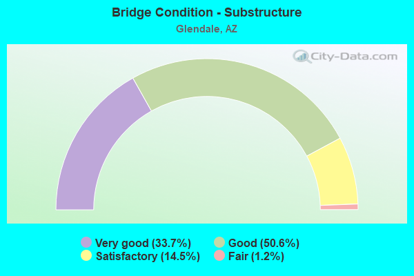
- Bridge Condition - Substructure
- 33.7%Very good
- 50.6%Good
- 14.5%Satisfactory
- 1.2%Fair
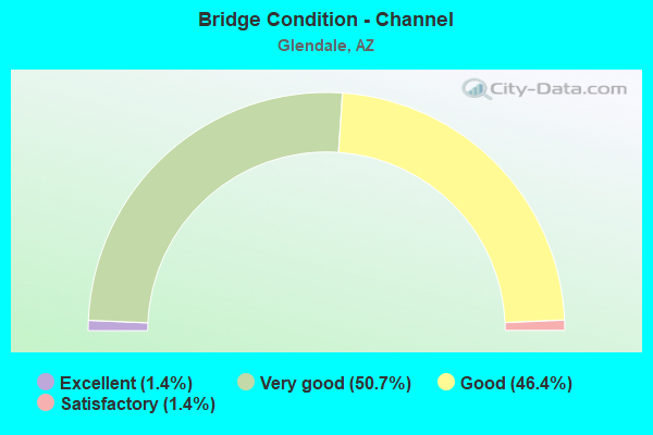
- Bridge Condition - Channel
- 1.4%Excellent
- 50.7%Very good
- 46.4%Good
- 1.4%Satisfactory
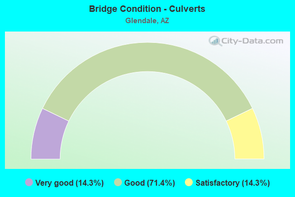
- Bridge Condition - Culverts
- 14.3%Very good
- 71.4%Good
- 14.3%Satisfactory
Find on map >> Show street view
Structure Number: 95, Location: 9.5 mi S Jct SR 10B (Lat: 31.875100, Lng: -110.210100), Route carried "on" structure: State highway 80, Year Built: 1933, Year Reconstructed: 1957, Status: Open, Structure Length: 3.41m (11.19ft), Average Daily Traffic: 3,673 (year 2019), Truck Traffic: 14%, Average Future Daily Traffic: 5,200 (year 2039), Design Load: HS 20, Features Intersected: Stronghold Wash
Minimum Vertical Clearance: 30+ m (98+ ft), Kilometerpoint: 487.309, Lanes on structure: 2, Owner: State Highway Agency, Approaching Roadway Width: 10.4m (34.1ft), Material/Design: Concrete continuous, Design/Construction: Slab, Number Of Spans In Main Unit: 5, Length of Maximum Span: 6.7m (22.0ft), Curb-To-Curb Width: 10.9m (35.8ft), Out-to-Out Width: 11.9m (39.0ft)
Condition: Deck: Fair, Superstructure: Fair, Substructure: Fair, Channel: Good, Operating Rating: 51.7 metric tons, Method Used To Determine Operating Rating: Load Factor (LF), Inventory Rating: 30.8 metric tons, Method Used To Determine Inventory Rating: Load Factor (LF), Structural Evaluation: Somewhat better than minimum adequacy, Deck Geometry: Somewhat better than minimum adequacy, Waterway Adequacy: Equal to present desirable criteria, Approach Roadway Alignment: Equal to present minimum criteria, Designated Inspection Frequency: Every 24 months, Inspection Date: March 2021, Deck Structure Type: Concrete Cast-file-Place, Wearing Surface/Protective System: Wearing Surface: Bituminous
Find on map >> Show street view
Structure Number: 1083, Location: 10.3 mi W of Jct I 17 (Lat: 35.238889, Lng: -111.827778), Route carried "on" structure: County highway , Year Built: 1963, Status: Open, Structure Length: 4.72m (15.49ft), Average Daily Traffic: 1,000 (year 2016), Truck Traffic: 12%, Average Future Daily Traffic: 1,010 (year 2036), Design Load: HS 20, Features Intersected: I 40; WB, Facility Carried by Structure: Transwestern Road
Minimum Vertical Clearance: 30+ m (98+ ft), Kilometerpoint: 0.000, Lanes on structure: 2, Lanes under structure: 2, Owner: State Highway Agency, Approaching Roadway Width: 10.4m (34.1ft), Material/Design: Steel continuous, Design/Construction: Stringer/Multi-beam, Number Of Spans In Main Unit: 3, Length of Maximum Span: 16.5m (54.1ft), Curb or Sidewalk Widths: Left: 0.5m (1.6ft), Right: 0.5m (1.6ft), Curb-To-Curb Width: 10.4m (34.1ft), Out-to-Out Width: 11.9m (39.0ft)
Condition: Deck: Very good, Superstructure: Very good, Substructure: Satisfactory, Operating Rating: 53.5 metric tons, Method Used To Determine Operating Rating: Load Factor (LF), Inventory Rating: 32.7 metric tons, Method Used To Determine Inventory Rating: Load Factor (LF), Structural Evaluation: Equal to present minimum criteria, Deck Geometry: Equal to present minimum criteria, Underclear: Meets minimum limits, Approach Roadway Alignment: Equal to present desirable criteria, Designated Inspection Frequency: Every 24 months, Inspection Date: August 2020, Deck Structure Type: Concrete Cast-file-Place, Wearing Surface/Protective System: Wearing Surface: Bituminous
Find on map >> Show street view
Structure Number: 1116, Location: 2.1 mi SW Utah State Line (Lat: 36.982700, Lng: -113.645900), Route carried "on" structure: County highway , Year Built: 1965, Status: Open, Structure Length: 4.15m (13.62ft), Average Daily Traffic: 100 (year 2018), Average Future Daily Traffic: 110 (year 2038), Design Load: HS 20, Features Intersected: I 15; SB, Facility Carried by Structure: Black Rock TI
Minimum Vertical Clearance: 30+ m (98+ ft), Kilometerpoint: 0.000, Lanes on structure: 2, Lanes under structure: 2, Owner: State Highway Agency, Approaching Roadway Width: 7.9m (25.9ft), Material/Design: Concrete continuous, Design/Construction: Tee Beam, Number Of Spans In Main Unit: 3, Length of Maximum Span: 14.3m (46.9ft), Curb or Sidewalk Widths: Left: 0.8m (2.6ft), Right: 0.8m (2.6ft), Curb-To-Curb Width: 7.9m (25.9ft), Out-to-Out Width: 9.5m (31.2ft)
Condition: Deck: Poor, Superstructure: Good, Substructure: Good, Operating Rating: 49.9 metric tons, Method Used To Determine Operating Rating: Load Factor (LF), Inventory Rating: 29.9 metric tons, Method Used To Determine Inventory Rating: Load Factor (LF), Structural Evaluation: Better than present minimum criteria, Deck Geometry: Equal to present minimum criteria, Underclear: High priority of corrective action, Approach Roadway Alignment: Equal to present desirable criteria, Designated Inspection Frequency: Every 24 months, Inspection Date: October 2020, Deck Structure Type: Concrete Cast-file-Place, Wearing Surface/Protective System: Wearing Surface: Monolithic Concrete
Find on map >> Show street view
Structure Number: 1136, Location: 52.7 mi E Jct US 95 (Lat: 32.728300, Lng: -113.737200), Route carried "on" structure: Interstate 8, Year Built: 1966, Status: Open, Structure Length: 4.66m (15.29ft), Average Daily Traffic: 4,959 (year 2017), Truck Traffic: 26%, Average Future Daily Traffic: 5,306 (year 2037), Design Load: HS 20, Features Intersected: SPRR; Mohawk
Minimum Vertical Clearance: 30+ m (98+ ft), Kilometerpoint: 88.310, Lanes on structure: 2, Owner: State Highway Agency, Approaching Roadway Width: 11.6m (38.1ft), Skew: 3 degrees, Material/Design: Steel continuous, Design/Construction: Stringer/Multi-beam, Number Of Spans In Main Unit: 3, Length of Maximum Span: 17.7m (58.1ft), Curb or Sidewalk Widths: Left: 0.2m (0.7ft), Right: 0.2m (0.7ft), Curb-To-Curb Width: 11.6m (38.1ft), Out-to-Out Width: 12.6m (41.3ft)
Condition: Deck: Good, Superstructure: Very good, Substructure: Good, Operating Rating: 54.4 metric tons, Method Used To Determine Operating Rating: Load Factor (LF), Inventory Rating: 32.7 metric tons, Method Used To Determine Inventory Rating: Load Factor (LF), Structural Evaluation: Better than present minimum criteria, Deck Geometry: Equal to present minimum criteria, Underclear: Somewhat better than minimum adequacy, Approach Roadway Alignment: Better than present minimum criteria, Designated Inspection Frequency: Every 24 months, Inspection Date: October 2020, Deck Structure Type: Concrete Cast-file-Place, Wearing Surface/Protective System: Wearing Surface: Bituminous
Find on map >> Show street view
Structure Number: 2051, Location: 17.24 mi N of Jct I 10 (Lat: 33.667500, Lng: -112.220400), Route carried "on" structure: City street , Year Built: 1990, Status: Open, Structure Length: 7.71m (25.30ft), Average Daily Traffic: 30,909 (year 2020), Truck Traffic: 5%, Average Future Daily Traffic: 30,919 (year 2040), Design Load: HS 20, Features Intersected: Loop 101, Facility Carried by Structure: 75th Avenue
Minimum Vertical Clearance: 7.62m (25.00ft), Kilometerpoint: 0.000, Lanes on structure: 7, Lanes under structure: 9, Owner: State Highway Agency, Approaching Roadway Width: 28.0m (91.9ft), Skew: 20 degrees, Material/Design: Prestressed concrete continuous, Design/Construction: Box Beam or Girders - Single/Spread, Number Of Spans In Main Unit: 2, Length of Maximum Span: 38.1m (125.0ft), Curb or Sidewalk Widths: Left: 1.8m (5.9ft), Right: 1.8m (5.9ft), Curb-To-Curb Width: 28.0m (91.9ft), Out-to-Out Width: 33.2m (108.9ft)
Condition: Deck: Satisfactory, Superstructure: Good, Substructure: Good, Operating Rating: 89.8 metric tons, Method Used To Determine Operating Rating: Load Factor (LF), Inventory Rating: 48.1 metric tons, Method Used To Determine Inventory Rating: Load Factor (LF), Structural Evaluation: Better than present minimum criteria, Deck Geometry: Somewhat better than minimum adequacy, Underclear: Meets minimum limits, Approach Roadway Alignment: Equal to present desirable criteria, Designated Inspection Frequency: Every 24 months, Inspection Date: May 2021, Deck Structure Type: Concrete Cast-file-Place, Wearing Surface/Protective System: Wearing Surface: Monolithic Concrete
Find on map >> Show street view
Structure Number: 2052, Location: 18.24 mi N of Jct I 10 (Lat: 33.667600, Lng: -112.203000), Route carried "on" structure: City street , Year Built: 1990, Status: Open, Structure Length: 7.96m (26.12ft), Average Daily Traffic: 21,965 (year 2020), Truck Traffic: 5%, Average Future Daily Traffic: 21,975 (year 2040), Design Load: HS 20, Features Intersected: Loop 101, Facility Carried by Structure: 67th Avenue
Minimum Vertical Clearance: 9.14m (29.99ft), Kilometerpoint: 0.000, Lanes on structure: 7, Lanes under structure: 8, Owner: State Highway Agency, Approaching Roadway Width: 24.4m (80.1ft), Material/Design: Prestressed concrete continuous, Design/Construction: Box Beam or Girders - Single/Spread, Number Of Spans In Main Unit: 2, Length of Maximum Span: 40.5m (132.9ft), Curb or Sidewalk Widths: Left: 1.8m (5.9ft), Right: 1.8m (5.9ft), Curb-To-Curb Width: 24.4m (80.1ft), Out-to-Out Width: 29.4m (96.5ft)
Condition: Deck: Satisfactory, Superstructure: Good, Substructure: Good, Operating Rating: 89.8 metric tons, Method Used To Determine Operating Rating: Load Factor (LF), Inventory Rating: 54.4 metric tons, Method Used To Determine Inventory Rating: Load Factor (LF), Structural Evaluation: Better than present minimum criteria, Deck Geometry: High priority of replacement, Underclear: Equal to present minimum criteria, Approach Roadway Alignment: Equal to present desirable criteria, Length Of Structure Improvement: 8.93m (29.30ft), Designated Inspection Frequency: Every 24 months, Inspection Date: May 2021, Bridge Improvement Cost: $2,000, Total Project Cost: $3,000 ( Estimate for 2021), Deck Structure Type: Concrete Cast-file-Place, Wearing Surface/Protective System: Wearing Surface: Monolithic Concrete
Find on map >> Show street view
Structure Number: 2053, Location: 4.21 mi W of Jct I 17 (Lat: 33.667800, Lng: -112.186700), Route carried "on" structure: City street , Year Built: 1990, Status: Open, Structure Length: 7.83m (25.69ft), Average Daily Traffic: 19,568 (year 2020), Truck Traffic: 5%, Average Future Daily Traffic: 19,578 (year 2040), Design Load: HS 20, Features Intersected: SL 101, Facility Carried by Structure: 59th Avenue
Minimum Vertical Clearance: 9.14m (29.99ft), Kilometerpoint: 0.000, Lanes on structure: 7, Lanes under structure: 8, Owner: State Highway Agency, Approaching Roadway Width: 28.0m (91.9ft), Skew: 20 degrees, Material/Design: Prestressed concrete continuous, Design/Construction: Box Beam or Girders - Single/Spread, Number Of Spans In Main Unit: 2, Length of Maximum Span: 39.0m (128.0ft), Curb or Sidewalk Widths: Left: 1.8m (5.9ft), Right: 1.8m (5.9ft), Curb-To-Curb Width: 28.0m (91.9ft), Out-to-Out Width: 33.1m (108.6ft)
Condition: Deck: Satisfactory, Superstructure: Good, Substructure: Good, Operating Rating: 80.7 metric tons, Method Used To Determine Operating Rating: Load Factor (LF), Inventory Rating: 43.5 metric tons, Method Used To Determine Inventory Rating: Load Factor (LF), Structural Evaluation: Better than present minimum criteria, Deck Geometry: Somewhat better than minimum adequacy, Underclear: Equal to present minimum criteria, Approach Roadway Alignment: Equal to present desirable criteria, Designated Inspection Frequency: Every 24 months, Inspection Date: May 2021, Deck Structure Type: Concrete Cast-file-Place, Wearing Surface/Protective System: Wearing Surface: Monolithic Concrete
Find on map >> Show street view
Structure Number: 206, Location: 3.3 mi N of Jct US 60 (Lat: 33.643700, Lng: -112.235700), Route carried "on" structure: City street , Year Built: 1990, Status: Open, Structure Length: 10.73m (35.20ft), Average Daily Traffic: 17,814 (year 2020), Truck Traffic: 5%, Average Future Daily Traffic: 17,824 (year 2040), Design Load: HS 20, Features Intersected: Loop 101, Facility Carried by Structure: 83rd Avenue
Minimum Vertical Clearance: 30+ m (98+ ft), Kilometerpoint: 0.000, Lanes on structure: 4, Lanes under structure: 10, Owner: State Highway Agency, Approaching Roadway Width: 20.7m (67.9ft), Skew: 3 degrees, Material/Design: Prestressed concrete continuous, Design/Construction: Box Beam or Girders - Single/Spread, Number Of Spans In Main Unit: 2, Length of Maximum Span: 52.4m (171.9ft), Curb or Sidewalk Widths: Left: 1.8m (5.9ft), Right: 1.8m (5.9ft), Curb-To-Curb Width: 20.7m (67.9ft), Out-to-Out Width: 25.8m (84.6ft)
Condition: Deck: Satisfactory, Superstructure: Satisfactory, Substructure: Satisfactory, Operating Rating: 67.1 metric tons, Method Used To Determine Operating Rating: Load Factor (LF), Inventory Rating: 39.9 metric tons, Method Used To Determine Inventory Rating: Load Factor (LF), Structural Evaluation: Equal to present minimum criteria, Deck Geometry: Superior to present desirable criteria, Underclear: High priority of corrective action, Approach Roadway Alignment: Equal to present desirable criteria, Designated Inspection Frequency: Every 24 months, Inspection Date: May 2021, Deck Structure Type: Concrete Cast-file-Place, Wearing Surface/Protective System: Wearing Surface: Monolithic Concrete
Find on map >> Show street view
Structure Number: 2069, Location: 20.19 mi N of Jct I 10 (Lat: 33.668400, Lng: -112.169600), Route carried "on" structure: State highway 101, Year Built: 1992, Status: Open, Structure Length: 5.58m (18.31ft), Average Daily Traffic: 163,830 (year 2020), Truck Traffic: 7%, Average Future Daily Traffic: 217,303 (year 2040), Design Load: HS 20, Features Intersected: 51st Avenue
Minimum Vertical Clearance: 30+ m (98+ ft), Kilometerpoint: 32.493, Lanes on structure: 8, Lanes under structure: 8, Owner: State Highway Agency, Approaching Roadway Width: 42.4m (139.1ft), Skew: 30 degrees, Material/Design: Prestressed concrete, Design/Construction: Box Beam or Girders - Multiple, Number Of Spans In Main Unit: 1, Length of Maximum Span: 30.5m (100.1ft), Curb-To-Curb Width: 42.5m (139.4ft), Out-to-Out Width: 44.3m (145.3ft)
Condition: Deck: Good, Superstructure: Good, Substructure: Good, Operating Rating: 82.6 metric tons, Method Used To Determine Operating Rating: Load Factor (LF), Inventory Rating: 36.3 metric tons, Method Used To Determine Inventory Rating: Load Factor (LF), Structural Evaluation: Better than present minimum criteria, Deck Geometry: Superior to present desirable criteria, Underclear: Meets minimum limits, Approach Roadway Alignment: Equal to present desirable criteria, Designated Inspection Frequency: Every 24 months, Inspection Date: May 2021, Deck Structure Type: Concrete Cast-file-Place, Wearing Surface/Protective System: Wearing Surface: Bituminous
Find on map >> Show street view
Structure Number: 2083, Location: 6.96 mi N Jct I-10 (Lat: 33.536900, Lng: -112.269600), Route carried "on" structure: State highway 101, Year Built: 1999, Status: Open, Structure Length: 6.49m (21.29ft), Average Daily Traffic: 117,867 (year 2019), Truck Traffic: 7%, Average Future Daily Traffic: 178,521 (year 2040), Design Load: HS 20, Features Intersected: Glendale Ave
Minimum Vertical Clearance: 30+ m (98+ ft), Kilometerpoint: 11.201, Lanes on structure: 4, Lanes under structure: 8, Owner: State Highway Agency, Approaching Roadway Width: 20.7m (67.9ft), Material/Design: Prestressed concrete, Design/Construction: Box Beam or Girders - Single/Spread, Number Of Spans In Main Unit: 1, Length of Maximum Span: 63.1m (207.0ft), Curb-To-Curb Width: 20.6m (67.6ft), Out-to-Out Width: 21.5m (70.5ft)
Condition: Deck: Good, Superstructure: Good, Substructure: Good, Operating Rating: 89.8 metric tons, Method Used To Determine Operating Rating: Load Factor (LF), Inventory Rating: 40.8 metric tons, Method Used To Determine Inventory Rating: Load Factor (LF), Structural Evaluation: Better than present minimum criteria, Deck Geometry: Equal to present minimum criteria, Underclear: Equal to present minimum criteria, Approach Roadway Alignment: Equal to present desirable criteria, Designated Inspection Frequency: Every 24 months, Inspection Date: April 2021, Deck Structure Type: Concrete Cast-file-Place, Wearing Surface/Protective System: Wearing Surface: Bituminous
Find on map >> Show street view
Structure Number: 2321, Location: SR101/Union Hills Dr (Lat: 33.653000, Lng: -112.232800), Route carried "on" structure: Ramp State highway 101, Year Built: 2010, Status: Open, Structure Length: 7.71m (25.30ft), Average Daily Traffic: 3,980 (year 2020), Truck Traffic: 6%, Average Future Daily Traffic: 3,990 (year 2040), Design Load: HS 25 or greater, Features Intersected: SR101, Facility Carried by Structure: Beardsley Ramp D
Minimum Vertical Clearance: 6.10m (20.01ft), Kilometerpoint: 0.000, Lanes on structure: 1, Lanes under structure: 8, Owner: State Highway Agency, Approaching Roadway Width: 12.2m (40.0ft), Material/Design: Prestressed concrete continuous, Design/Construction: Box Beam or Girders - Multiple, Number Of Spans In Main Unit: 2, Length of Maximum Span: 38.1m (125.0ft), Curb-To-Curb Width: 12.2m (40.0ft), Out-to-Out Width: 13.2m (43.3ft)
Condition: Deck: Good, Superstructure: Very good, Substructure: Very good, Operating Rating: 89.8 metric tons, Method Used To Determine Operating Rating: Load Factor (LF), Inventory Rating: 52.6 metric tons, Method Used To Determine Inventory Rating: Load Factor (LF), Structural Evaluation: Equal to present desirable criteria, Deck Geometry: Superior to present desirable criteria, Underclear: Meets minimum limits, Approach Roadway Alignment: Equal to present desirable criteria, Designated Inspection Frequency: Every 24 months, Inspection Date: May 2021, Deck Structure Type: Concrete Cast-file-Place, Wearing Surface/Protective System: Wearing Surface: Monolithic Concrete
Find on map >> Show street view
Structure Number: 2545, Location: 6.96 mi N Jct I-10 (Lat: 33.536900, Lng: -112.269900), Route carried "on" structure: State highway 101, Year Built: 1999, Status: Open, Structure Length: 6.49m (21.29ft), Average Daily Traffic: 117,867 (year 2019), Truck Traffic: 7%, Average Future Daily Traffic: 178,521 (year 2040), Design Load: HS 20, Features Intersected: Glendale Ave
Minimum Vertical Clearance: 30+ m (98+ ft), Kilometerpoint: 11.201, Lanes on structure: 4, Lanes under structure: 8, Owner: State Highway Agency, Approaching Roadway Width: 20.7m (67.9ft), Material/Design: Prestressed concrete, Design/Construction: Box Beam or Girders - Single/Spread, Number Of Spans In Main Unit: 1, Length of Maximum Span: 63.1m (207.0ft), Curb-To-Curb Width: 20.6m (67.6ft), Out-to-Out Width: 21.5m (70.5ft)
Condition: Deck: Good, Superstructure: Good, Substructure: Good, Operating Rating: 89.8 metric tons, Method Used To Determine Operating Rating: Load Factor (LF), Inventory Rating: 40.8 metric tons, Method Used To Determine Inventory Rating: Load Factor (LF), Structural Evaluation: Better than present minimum criteria, Deck Geometry: Equal to present minimum criteria, Underclear: Equal to present minimum criteria, Approach Roadway Alignment: Equal to present desirable criteria, Designated Inspection Frequency: Every 24 months, Inspection Date: April 2021, Deck Structure Type: Concrete Cast-file-Place, Wearing Surface/Protective System: Wearing Surface: Bituminous
Find on map >> Show street view
Structure Number: 2546, Location: 6 mi North of I 10 (Lat: 33.522500, Lng: -112.268900), Route carried "on" structure: State highway 101, Year Built: 2000, Status: Open, Structure Length: 12.07m (39.60ft), Average Daily Traffic: 119,432 (year 2019), Truck Traffic: 7%, Average Future Daily Traffic: 157,290 (year 2040), Design Load: HS 20, Features Intersected: B. Home Rd. & canals
Minimum Vertical Clearance: 0.00m, Kilometerpoint: 9.660, Lanes on structure: 4, Lanes under structure: 8, Owner: State Highway Agency, Approaching Roadway Width: 20.7m (67.9ft), Material/Design: Prestressed concrete continuous, Design/Construction: Stringer/Multi-beam, Number Of Spans In Main Unit: 3, Length of Maximum Span: 39.9m (130.9ft), Curb-To-Curb Width: 20.6m (67.6ft), Out-to-Out Width: 21.5m (70.5ft)
Condition: Deck: Good, Superstructure: Very good, Substructure: Good, Channel: Very good, Operating Rating: 89.8 metric tons, Method Used To Determine Operating Rating: Load Factor (LF), Inventory Rating: 32.7 metric tons, Method Used To Determine Inventory Rating: Load Factor (LF), Structural Evaluation: Better than present minimum criteria, Deck Geometry: Equal to present minimum criteria, Waterway Adequacy: Equal to present desirable criteria, Approach Roadway Alignment: Equal to present desirable criteria, Designated Inspection Frequency: Every 24 months, Inspection Date: April 2021, Deck Structure Type: Concrete Cast-file-Place, Wearing Surface/Protective System: Wearing Surface: Bituminous
Find on map >> Show street view
Structure Number: 2547, Location: 6 mi North of I 10 (Lat: 33.522500, Lng: -112.269200), Route carried "on" structure: State highway 101, Year Built: 2000, Status: Open, Structure Length: 12.07m (39.60ft), Average Daily Traffic: 119,432 (year 2019), Truck Traffic: 7%, Average Future Daily Traffic: 157,290 (year 2040), Design Load: HS 20, Features Intersected: B. Home Rd & canals
Minimum Vertical Clearance: 30+ m (98+ ft), Kilometerpoint: 9.660, Lanes on structure: 4, Lanes under structure: 8, Owner: State Highway Agency, Approaching Roadway Width: 20.7m (67.9ft), Material/Design: Prestressed concrete continuous, Design/Construction: Stringer/Multi-beam, Number Of Spans In Main Unit: 3, Length of Maximum Span: 39.9m (130.9ft), Curb-To-Curb Width: 20.6m (67.6ft), Out-to-Out Width: 21.5m (70.5ft)
Condition: Deck: Good, Superstructure: Good, Substructure: Good, Channel: Very good, Operating Rating: 89.8 metric tons, Method Used To Determine Operating Rating: Load Factor (LF), Inventory Rating: 38.1 metric tons, Method Used To Determine Inventory Rating: Load Factor (LF), Structural Evaluation: Better than present minimum criteria, Deck Geometry: Equal to present minimum criteria, Waterway Adequacy: Equal to present desirable criteria, Approach Roadway Alignment: Equal to present desirable criteria, Designated Inspection Frequency: Every 24 months, Inspection Date: April 2021, Deck Structure Type: Concrete Cast-file-Place, Wearing Surface/Protective System: Wearing Surface: Bituminous
Find on map >> Show street view
Structure Number: 2651, Location: 43rd Ave @ Camelback Rd (Lat: 33.511600, Lng: -112.153700), Route carried "on" structure: US 60, Year Built: 2004, Status: Open, Structure Length: 1.22m (4.00ft), Average Daily Traffic: 43,933 (year 2017), Truck Traffic: 6%, Average Future Daily Traffic: 43,943 (year 2037), Design Load: HS 20, Features Intersected: Grand Avenue Ramp
Minimum Vertical Clearance: 30+ m (98+ ft), Kilometerpoint: 253.069, Lanes on structure: 6, Lanes under structure: 6, Owner: State Highway Agency, Approaching Roadway Width: 31.1m (102.0ft), Skew: 35 degrees, Material/Design: Concrete, Design/Construction: Frame, Number Of Spans In Main Unit: 1, Length of Maximum Span: 10.7m (35.1ft), Curb-To-Curb Width: 30.9m (101.4ft), Out-to-Out Width: 83.8m (274.9ft)
Condition: Deck: Good, Superstructure: Good, Substructure: Good, Operating Rating: 89.8 metric tons, Method Used To Determine Operating Rating: Load Factor (LF), Inventory Rating: 74.4 metric tons, Method Used To Determine Inventory Rating: Load Factor (LF), Structural Evaluation: Better than present minimum criteria, Deck Geometry: Superior to present desirable criteria, Underclear: Meets minimum limits, Approach Roadway Alignment: Equal to present desirable criteria, Designated Inspection Frequency: Every 24 months, Inspection Date: August 2020, Deck Structure Type: Concrete Cast-file-Place, Wearing Surface/Protective System: Wearing Surface: Bituminous
Find on map >> Show street view
Structure Number: 2652, Location: 43rd Ave @ Camelback (Lat: 33.510200, Lng: -112.151900), Route carried "on" structure: US 60, Year Built: 2004, Status: Open, Structure Length: 15.27m (50.10ft), Average Daily Traffic: 20,420 (year 2019), Truck Traffic: 5%, Average Future Daily Traffic: 20,430 (year 2039), Design Load: HS 20, Features Intersected: 43rd Ave & Camelback
Minimum Vertical Clearance: 9.14m (29.99ft), Kilometerpoint: 253.568, Lanes on structure: 3, Lanes under structure: 16, Owner: State Highway Agency, Approaching Roadway Width: 15.2m (49.9ft), Material/Design: Prestressed concrete continuous, Design/Construction: Stringer/Multi-beam, Number Of Spans In Main Unit: 4, Length of Maximum Span: 42.7m (140.1ft), Curb-To-Curb Width: 15.2m (49.9ft), Out-to-Out Width: 16.2m (53.1ft)
Condition: Deck: Good, Superstructure: Very good, Substructure: Very good, Operating Rating: 89.8 metric tons, Method Used To Determine Operating Rating: Load Factor (LF), Inventory Rating: 37.2 metric tons, Method Used To Determine Inventory Rating: Load Factor (LF), Structural Evaluation: Equal to present desirable criteria, Deck Geometry: Equal to present minimum criteria, Underclear: Meets minimum limits, Approach Roadway Alignment: Equal to present desirable criteria, Designated Inspection Frequency: Every 24 months, Inspection Date: September 2020, Deck Structure Type: Concrete Cast-file-Place, Wearing Surface/Protective System: Wearing Surface: Monolithic Concrete
Find on map >> Show street view
Structure Number: 2653, Location: 43rd Ave @ Camelback (Lat: 33.510400, Lng: -112.151900), Route carried "on" structure: US 60, Year Built: 2004, Status: Open, Structure Length: 18.38m (60.30ft), Average Daily Traffic: 20,821 (year 2019), Truck Traffic: 5%, Average Future Daily Traffic: 20,831 (year 2039), Design Load: HS 20, Features Intersected: 43rd Ave & Camelback Rd
Minimum Vertical Clearance: 9.14m (29.99ft), Kilometerpoint: 253.568, Lanes on structure: 3, Lanes under structure: 16, Owner: State Highway Agency, Approaching Roadway Width: 15.2m (49.9ft), Material/Design: Prestressed concrete continuous, Design/Construction: Stringer/Multi-beam, Number Of Spans In Main Unit: 5, Length of Maximum Span: 42.4m (139.1ft), Curb-To-Curb Width: 15.2m (49.9ft), Out-to-Out Width: 16.2m (53.1ft)
Condition: Deck: Good, Superstructure: Very good, Substructure: Good, Operating Rating: 89.8 metric tons, Method Used To Determine Operating Rating: Load Factor (LF), Inventory Rating: 38.1 metric tons, Method Used To Determine Inventory Rating: Load Factor (LF), Structural Evaluation: Better than present minimum criteria, Deck Geometry: Equal to present minimum criteria, Underclear: Meets minimum limits, Approach Roadway Alignment: Equal to present desirable criteria, Designated Inspection Frequency: Every 24 months, Inspection Date: September 2020, Deck Structure Type: Concrete Cast-file-Place, Wearing Surface/Protective System: Wearing Surface: Monolithic Concrete
Find on map >> Show street view
Structure Number: 2698, Location: 59th Av/Glendale Ave/US60 (Lat: 33.538600, Lng: -112.186300), Route carried "on" structure: City street , Year Built: 2007, Status: Open, Structure Length: 2.93m (9.61ft), Average Daily Traffic: 38,928 (year 2019), Truck Traffic: 5%, Average Future Daily Traffic: 38,938 (year 2039), Design Load: HS 20, Features Intersected: US 60, Facility Carried by Structure: 59th Ave/Glendale
Minimum Vertical Clearance: 5.41m (17.75ft), Kilometerpoint: 0.000, Lanes on structure: 5, Lanes under structure: 6, Owner: State Highway Agency, Approaching Roadway Width: 34.7m (113.8ft), Skew: 20 degrees, Material/Design: Prestressed concrete, Design/Construction: Stringer/Multi-beam, Number Of Spans In Main Unit: 1, Length of Maximum Span: 28.3m (92.8ft), Curb or Sidewalk Widths: Left: 1.8m (5.9ft), Right: 1.8m (5.9ft), Curb-To-Curb Width: 34.7m (113.8ft), Out-to-Out Width: 87.2m (286.1ft)
Condition: Deck: Satisfactory, Superstructure: Very good, Substructure: Very good, Operating Rating: 83.5 metric tons, Method Used To Determine Operating Rating: Load Factor (LF), Inventory Rating: 33.6 metric tons, Method Used To Determine Inventory Rating: Load Factor (LF), Structural Evaluation: Equal to present desirable criteria, Deck Geometry: Superior to present desirable criteria, Underclear: High priority of corrective action, Approach Roadway Alignment: Equal to present minimum criteria, Designated Inspection Frequency: Every 24 months, Inspection Date: July 2020, Deck Structure Type: Concrete Cast-file-Place, Wearing Surface/Protective System: Wearing Surface: Monolithic Concrete
Find on map >> Show street view
Structure Number: 2699, Location: 67th Ave @ Northern (Lat: 33.552100, Lng: -112.203600), Route carried "on" structure: City street , Year Built: 2005, Status: Open, Structure Length: 23.96m (78.61ft), Average Daily Traffic: 27,278 (year 2019), Truck Traffic: 4%, Average Future Daily Traffic: 27,288 (year 2039), Design Load: HS 20, Features Intersected: Northern Ave & RR, Facility Carried by Structure: 67th Ave
Minimum Vertical Clearance: 5.49m (18.01ft), Kilometerpoint: 0.000, Lanes on structure: 4, Lanes under structure: 15, Owner: State Highway Agency, Approaching Roadway Width: 17.1m (56.1ft), Skew: 39 degrees, Material/Design: Prestressed concrete continuous, Design/Construction: Stringer/Multi-beam, Number Of Spans In Main Unit: 6, Length of Maximum Span: 41.8m (137.1ft), Curb-To-Curb Width: 17.1m (56.1ft), Out-to-Out Width: 18.5m (60.7ft)
Condition: Deck: Good, Superstructure: Very good, Substructure: Very good, Operating Rating: 89.8 metric tons, Method Used To Determine Operating Rating: Load Factor (LF), Inventory Rating: 32.7 metric tons, Method Used To Determine Inventory Rating: Load Factor (LF), Structural Evaluation: Equal to present desirable criteria, Deck Geometry: Somewhat better than minimum adequacy, Underclear: High priority of corrective action, Approach Roadway Alignment: Equal to present desirable criteria, Designated Inspection Frequency: Every 24 months, Inspection Date: July 2020, Deck Structure Type: Concrete Cast-file-Place, Wearing Surface/Protective System: Wearing Surface: Monolithic Concrete
Find on map >> Show street view
Structure Number: 2707, Location: Maryland @ 55th Ave (Lat: 33.531800, Lng: -112.178800), Route carried "on" structure: City street , Year Built: 2004, Status: Open, Structure Length: 15.18m (49.80ft), Average Daily Traffic: 4,442 (year 2019), Truck Traffic: 3%, Average Future Daily Traffic: 4,452 (year 2039), Design Load: HS 20, Features Intersected: 55th Ave & US 60, Facility Carried by Structure: Maryland Avenue
Minimum Vertical Clearance: 30+ m (98+ ft), Kilometerpoint: 0.000, Lanes on structure: 2, Lanes under structure: 7, Owner: State Highway Agency, Approaching Roadway Width: 14.6m (47.9ft), Skew: 4 degrees, Material/Design: Prestressed concrete continuous, Design/Construction: Stringer/Multi-beam, Number Of Spans In Main Unit: 3, Length of Maximum Span: 54.3m (178.1ft), Curb or Sidewalk Widths: Left: 1.8m (5.9ft), Right: 1.8m (5.9ft), Curb-To-Curb Width: 14.6m (47.9ft), Out-to-Out Width: 18.9m (62.0ft)
Condition: Deck: Good, Superstructure: Very good, Substructure: Very good, Operating Rating: 89.8 metric tons, Method Used To Determine Operating Rating: Load Factor (LF), Inventory Rating: 33.6 metric tons, Method Used To Determine Inventory Rating: Load Factor (LF), Structural Evaluation: Equal to present desirable criteria, Deck Geometry: Superior to present desirable criteria, Underclear: Equal to present minimum criteria, Approach Roadway Alignment: Equal to present desirable criteria, Designated Inspection Frequency: Every 24 months, Inspection Date: July 2020, Deck Structure Type: Concrete Cast-file-Place, Wearing Surface/Protective System: Wearing Surface: Monolithic Concrete
Find on map >> Show street view
Structure Number: 2851, Location: 0.5 mi S Glendale Ave (Lat: 33.530100, Lng: -112.269700), Route carried "on" structure: City street , Year Built: 2007, Status: Open, Structure Length: 12.16m (39.90ft), Average Daily Traffic: 6,500 (year 2021), Truck Traffic: 5%, Average Future Daily Traffic: 6,510 (year 2041), Design Load: HS 20, Features Intersected: 101L, Facility Carried by Structure: Maryland Ave
Minimum Vertical Clearance: 30+ m (98+ ft), Kilometerpoint: 0.000, Lanes on structure: 5, Lanes under structure: 10, Owner: State Highway Agency, Approaching Roadway Width: 20.7m (67.9ft), Material/Design: Prestressed concrete continuous, Design/Construction: Stringer/Multi-beam, Number Of Spans In Main Unit: 3, Length of Maximum Span: 39.9m (130.9ft), Curb or Sidewalk Widths: Left: 2.4m (7.9ft), Right: 2.4m (7.9ft), Curb-To-Curb Width: 20.7m (67.9ft), Out-to-Out Width: 26.2m (86.0ft)
Condition: Deck: Very good, Superstructure: Good, Substructure: Good, Channel: Very good, Operating Rating: 89.8 metric tons, Method Used To Determine Operating Rating: Load Factor (LF), Inventory Rating: 32.7 metric tons, Method Used To Determine Inventory Rating: Load Factor (LF), Structural Evaluation: Better than present minimum criteria, Deck Geometry: Somewhat better than minimum adequacy, Underclear: Meets minimum limits, Waterway Adequacy: Equal to present desirable criteria, Approach Roadway Alignment: Equal to present desirable criteria, Designated Inspection Frequency: Every 24 months, Inspection Date: November 2021, Deck Structure Type: Concrete Cast-file-Place, Wearing Surface/Protective System: Wearing Surface: Monolithic Concrete
Find on map >> Show street view
Structure Number: 2928, Location: 4.4 miles N I-10 (Lat: 33.528500, Lng: -112.269100), Route carried "on" structure: Ramp State highway 101, Year Built: 2014, Status: Open, Structure Length: 15.97m (52.40ft), Average Daily Traffic: 8,000 (year 2020), Truck Traffic: 7%, Average Future Daily Traffic: 8,010 (year 2040), Design Load: HL 93, Features Intersected: SR101L
Minimum Vertical Clearance: 6.10m (20.01ft), Kilometerpoint: 10.300, Lanes on structure: 2, Owner: State Highway Agency, Approaching Roadway Width: 16.5m (54.1ft), Skew: 30 degrees, Material/Design: Concrete continuous, Design/Construction: Slab, Number Of Spans In Main Unit: 15, Length of Maximum Span: 10.7m (35.1ft), Curb-To-Curb Width: 16.5m (54.1ft), Out-to-Out Width: 18.1m (59.4ft)
Condition: Deck: Very good, Superstructure: Very good, Substructure: Very good, Operating Rating: 57.2 metric tons, Method Used To Determine Operating Rating: Load Factor (LF), Inventory Rating: 33.6 metric tons, Method Used To Determine Inventory Rating: Load Factor (LF), Structural Evaluation: Equal to present desirable criteria, Deck Geometry: Superior to present desirable criteria, Approach Roadway Alignment: Equal to present desirable criteria, Designated Inspection Frequency: Every 24 months, Critical Feature Inspection Frequency: Every 24 months, Inspection Date: July 2020, Critical Feature Inspection Date: July 2020, Deck Structure Type: Concrete Cast-file-Place, Wearing Surface/Protective System: Wearing Surface: Monolithic Concrete
Find on map >> Show street view
Structure Number: 294, Location: 4.4 miles N I-10 (Lat: 33.530200, Lng: -112.269200), Route carried "on" structure: Ramp State highway 101, Year Built: 2014, Status: Open, Structure Length: 14.23m (46.69ft), Average Daily Traffic: 8,000 (year 2020), Truck Traffic: 7%, Average Future Daily Traffic: 8,010 (year 2040), Design Load: HL 93, Features Intersected: SR 101L
Minimum Vertical Clearance: 6.10m (20.01ft), Kilometerpoint: 10.477, Lanes on structure: 3, Owner: State Highway Agency, Approaching Roadway Width: 16.5m (54.1ft), Skew: 30 degrees, Material/Design: Concrete continuous, Design/Construction: Slab, Number Of Spans In Main Unit: 13, Length of Maximum Span: 11.0m (36.1ft), Curb-To-Curb Width: 16.5m (54.1ft), Out-to-Out Width: 18.1m (59.4ft)
Condition: Deck: Very good, Superstructure: Very good, Substructure: Very good, Operating Rating: 52.6 metric tons, Method Used To Determine Operating Rating: Load Factor (LF), Inventory Rating: 31.8 metric tons, Method Used To Determine Inventory Rating: Load Factor (LF), Structural Evaluation: Better than present minimum criteria, Deck Geometry: Superior to present desirable criteria, Approach Roadway Alignment: Equal to present desirable criteria, Designated Inspection Frequency: Every 24 months, Critical Feature Inspection Frequency: Every 24 months, Inspection Date: July 2020, Critical Feature Inspection Date: July 2020, Deck Structure Type: Concrete Cast-file-Place, Wearing Surface/Protective System: Wearing Surface: Monolithic Concrete
Find on map >> Show street view
Structure Number: 2968, Location: 130' N of Bethany Home Rd (Lat: 33.523100, Lng: -112.269400), Route carried "on" structure: ServiceState highway 101, Year Built: 2008, Status: Open, Structure Length: 1.31m (4.30ft), Average Daily Traffic: 10 (year 2018), Average Future Daily Traffic: 20 (year 2038), Design Load: HS 20, Features Intersected: Grand Canal, Facility Carried by Structure: E Cnl Br Crossover
Minimum Vertical Clearance: 30+ m (98+ ft), Kilometerpoint: 9.672, Lanes on structure: 2, Owner: State Highway Agency, Approaching Roadway Width: 14.6m (47.9ft), Material/Design: Prestressed concrete, Design/Construction: Box Beam or Girders - Multiple, Number Of Spans In Main Unit: 1, Length of Maximum Span: 11.6m (38.1ft), Curb-To-Curb Width: 14.6m (47.9ft), Out-to-Out Width: 15.5m (50.9ft)
Condition: Deck: Very good, Superstructure: Very good, Substructure: Good, Channel: Good, Operating Rating: 75.3 metric tons, Method Used To Determine Operating Rating: Load Factor (LF), Inventory Rating: 45.4 metric tons, Method Used To Determine Inventory Rating: Load Factor (LF), Structural Evaluation: Better than present minimum criteria, Deck Geometry: Superior to present desirable criteria, Waterway Adequacy: Equal to present desirable criteria, Approach Roadway Alignment: Equal to present desirable criteria, Designated Inspection Frequency: Every 24 months, Inspection Date: January 2022, Deck Structure Type: Concrete Cast-file-Place, Wearing Surface/Protective System: Wearing Surface: Monolithic Concrete
Find on map >> Show street view
Structure Number: 2969, Location: 4.3 mi N I-10 (Lat: 33.522400, Lng: -112.418500), Route carried "on" structure: State highway 303, Year Built: 2014, Status: Open, Structure Length: 6.98m (22.90ft), Average Daily Traffic: 29,038 (year 2019), Truck Traffic: 7%, Average Future Daily Traffic: 29,048 (year 2039), Design Load: HL 93, Features Intersected: Bethany Home Rd
Minimum Vertical Clearance: 30+ m (98+ ft), Kilometerpoint: 174.067, Lanes on structure: 3, Lanes under structure: 4, Base Highway Network: Yes, Owner: State Highway Agency, Approaching Roadway Width: 25.3m (83.0ft), Material/Design: Prestressed concrete continuous, Design/Construction: Stringer/Multi-beam, Number Of Spans In Main Unit: 2, Length of Maximum Span: 34.7m (113.8ft), Curb-To-Curb Width: 25.4m (83.3ft), Out-to-Out Width: 26.3m (86.3ft)
Condition: Deck: Very good, Superstructure: Very good, Substructure: Very good, Operating Rating: 89.8 metric tons, Method Used To Determine Operating Rating: Load Factor (LF), Inventory Rating: 39.9 metric tons, Method Used To Determine Inventory Rating: Load Factor (LF), Structural Evaluation: Equal to present desirable criteria, Deck Geometry: Superior to present desirable criteria, Underclear: Superior to present desirable criteria, Approach Roadway Alignment: Equal to present desirable criteria, Designated Inspection Frequency: Every 24 months, Inspection Date: July 2020, Deck Structure Type: Concrete Cast-file-Place, Wearing Surface/Protective System: Wearing Surface: Bituminous
Find on map >> Show street view
Structure Number: 297, Location: 4.3 mi N I-10 (Lat: 33.522400, Lng: -112.418800), Route carried "on" structure: State highway 303, Year Built: 2014, Status: Open, Structure Length: 6.98m (22.90ft), Average Daily Traffic: 24,942 (year 2019), Truck Traffic: 7%, Average Future Daily Traffic: 24,952 (year 2039), Design Load: HL 93, Features Intersected: Bethany Home Rd
Minimum Vertical Clearance: 30+ m (98+ ft), Kilometerpoint: 174.067, Lanes on structure: 3, Lanes under structure: 4, Base Highway Network: Yes, Owner: State Highway Agency, Approaching Roadway Width: 29.0m (95.1ft), Material/Design: Prestressed concrete continuous, Design/Construction: Stringer/Multi-beam, Number Of Spans In Main Unit: 2, Length of Maximum Span: 34.7m (113.8ft), Curb-To-Curb Width: 29.0m (95.1ft), Out-to-Out Width: 30.0m (98.4ft)
Condition: Deck: Very good, Superstructure: Very good, Substructure: Very good, Operating Rating: 89.8 metric tons, Method Used To Determine Operating Rating: Load Factor (LF), Inventory Rating: 35.4 metric tons, Method Used To Determine Inventory Rating: Load Factor (LF), Structural Evaluation: Equal to present desirable criteria, Deck Geometry: Superior to present desirable criteria, Underclear: Superior to present desirable criteria, Approach Roadway Alignment: Equal to present desirable criteria, Designated Inspection Frequency: Every 24 months, Inspection Date: July 2020, Deck Structure Type: Concrete Cast-file-Place, Wearing Surface/Protective System: Wearing Surface: Bituminous
Find on map >> Show street view
Structure Number: 2971, Location: 130' N Bethany Home Rd (Lat: 33.523000, Lng: -112.269800), Route carried "on" structure: ServiceState highway 101, Year Built: 2008, Status: Open, Structure Length: 1.31m (4.30ft), Average Daily Traffic: 10 (year 2017), Average Future Daily Traffic: 20 (year 2037), Design Load: HS 20, Features Intersected: W Cnl Br Crossover, Facility Carried by Structure: Grand Canal
Minimum Vertical Clearance: 30+ m (98+ ft), Kilometerpoint: 9.672, Lanes on structure: 2, Owner: State Highway Agency, Approaching Roadway Width: 14.6m (47.9ft), Material/Design: Prestressed concrete, Design/Construction: Box Beam or Girders - Multiple, Number Of Spans In Main Unit: 1, Length of Maximum Span: 11.6m (38.1ft), Curb-To-Curb Width: 14.6m (47.9ft), Out-to-Out Width: 15.5m (50.9ft)
Condition: Deck: Very good, Superstructure: Very good, Substructure: Very good, Channel: Good, Operating Rating: 75.3 metric tons, Method Used To Determine Operating Rating: Load Factor (LF), Inventory Rating: 45.4 metric tons, Method Used To Determine Inventory Rating: Load Factor (LF), Structural Evaluation: Equal to present desirable criteria, Deck Geometry: Superior to present desirable criteria, Waterway Adequacy: Equal to present desirable criteria, Approach Roadway Alignment: Equal to present desirable criteria, Designated Inspection Frequency: Every 24 months, Inspection Date: January 2022, Deck Structure Type: Concrete Cast-file-Place, Wearing Surface/Protective System: Wearing Surface: Monolithic Concrete
Find on map >> Show street view
Structure Number: 2972, Location: 103' N of Bethany Home Rd (Lat: 33.523100, Lng: -112.268300), Route carried "on" structure: ServiceState highway 101, Year Built: 2008, Status: Open, Structure Length: 1.31m (4.30ft), Average Daily Traffic: 10 (year 2018), Average Future Daily Traffic: 20 (year 2038), Design Load: HS 20, Features Intersected: W Cnl Br Crossover, Facility Carried by Structure: Grand Canal
Minimum Vertical Clearance: 30+ m (98+ ft), Kilometerpoint: 9.672, Lanes on structure: 2, Owner: State Highway Agency, Approaching Roadway Width: 14.6m (47.9ft), Material/Design: Prestressed concrete, Design/Construction: Box Beam or Girders - Multiple, Number Of Spans In Main Unit: 1, Length of Maximum Span: 11.6m (38.1ft), Curb-To-Curb Width: 14.6m (47.9ft), Out-to-Out Width: 15.5m (50.9ft)
Condition: Deck: Good, Superstructure: Very good, Substructure: Very good, Channel: Very good, Operating Rating: 75.3 metric tons, Method Used To Determine Operating Rating: Load Factor (LF), Inventory Rating: 45.4 metric tons, Method Used To Determine Inventory Rating: Load Factor (LF), Structural Evaluation: Equal to present desirable criteria, Deck Geometry: Superior to present desirable criteria, Waterway Adequacy: Equal to present desirable criteria, Approach Roadway Alignment: Equal to present desirable criteria, Designated Inspection Frequency: Every 24 months, Inspection Date: January 2022, Deck Structure Type: Concrete Cast-file-Place, Wearing Surface/Protective System: Wearing Surface: Monolithic Concrete
Find on map >> Show street view
Structure Number: 2973, Location: 103' N of Bethany Home Rd (Lat: 33.523100, Lng: -112.268600), Route carried "on" structure: ServiceState highway 101, Year Built: 2008, Status: Open, Structure Length: 1.31m (4.30ft), Average Daily Traffic: 10 (year 2018), Average Future Daily Traffic: 20 (year 2038), Design Load: HS 20, Features Intersected: W Cnl Br Crossover, Facility Carried by Structure: Grand Canal
Minimum Vertical Clearance: 30+ m (98+ ft), Kilometerpoint: 9.672, Lanes on structure: 2, Owner: State Highway Agency, Approaching Roadway Width: 14.6m (47.9ft), Material/Design: Prestressed concrete, Design/Construction: Box Beam or Girders - Multiple, Number Of Spans In Main Unit: 1, Length of Maximum Span: 11.6m (38.1ft), Curb-To-Curb Width: 14.6m (47.9ft), Out-to-Out Width: 15.5m (50.9ft)
Condition: Deck: Very good, Superstructure: Very good, Substructure: Very good, Channel: Very good, Operating Rating: 75.3 metric tons, Method Used To Determine Operating Rating: Load Factor (LF), Inventory Rating: 45.4 metric tons, Method Used To Determine Inventory Rating: Load Factor (LF), Structural Evaluation: Equal to present desirable criteria, Deck Geometry: Superior to present desirable criteria, Waterway Adequacy: Equal to present desirable criteria, Approach Roadway Alignment: Equal to present desirable criteria, Designated Inspection Frequency: Every 24 months, Inspection Date: January 2022, Deck Structure Type: Concrete Cast-file-Place, Wearing Surface/Protective System: Wearing Surface: Monolithic Concrete
Find on map >> Show street view
Structure Number: 6825, Location: 7.74 mi N Jct I-10 (Lat: 33.547700, Lng: -112.270600), Route carried "on" structure: State highway 101, Year Built: 1987, Status: Open, Structure Length: 3.17m (10.40ft), Average Daily Traffic: 131,758 (year 2019), Truck Traffic: 4%, Average Future Daily Traffic: 169,328 (year 2040), Design Load: HS 20, Features Intersected: 101 Drain Channel
Minimum Vertical Clearance: 30+ m (98+ ft), Kilometerpoint: 12.460, Lanes on structure: 10, Owner: State Highway Agency, Approaching Roadway Width: 43.9m (144.0ft), Skew: 33 degrees, Material/Design: Concrete continuous, Design/Construction: Culvert, Number Of Spans In Main Unit: 8, Length of Maximum Span: 3.0m (9.8ft)
Condition: Channel: Very good, Culverts: Good, Operating Rating: 89.8 metric tons, Method Used To Determine Operating Rating: Load Factor (LF), Inventory Rating: 74.4 metric tons, Method Used To Determine Inventory Rating: Load Factor (LF), Structural Evaluation: Better than present minimum criteria, Waterway Adequacy: Equal to present desirable criteria, Approach Roadway Alignment: Equal to present desirable criteria, Length Of Structure Improvement: 3.96m (12.99ft), Designated Inspection Frequency: Every 48 months, Inspection Date: April 2021, Bridge Improvement Cost: $3,000, Roadway Improvement Cost: $1,000, Total Project Cost: $5,000 ( Estimate for 2021)
Find on map >> Show street view
Structure Number: 6826, Location: 7.68 mi N Jct I-10 (Lat: 33.558333, Lng: -112.277778), Route carried "on" structure: ServiceState highway 101, Year Built: 1987, Status: Open, Structure Length: 2.65m (8.69ft), Average Daily Traffic: 5,300 (year 2019), Truck Traffic: 5%, Average Future Daily Traffic: 5,310 (year 2039), Design Load: HS 20, Features Intersected: 101 Drain Channel, Facility Carried by Structure: 99th Ave
Minimum Vertical Clearance: 30+ m (98+ ft), Kilometerpoint: 12.360, Lanes on structure: 2, Owner: State Highway Agency, Approaching Roadway Width: 8.5m (27.9ft), Material/Design: Concrete continuous, Design/Construction: Culvert, Number Of Spans In Main Unit: 8, Length of Maximum Span: 3.0m (9.8ft), Curb-To-Curb Width: 28.3m (92.8ft), Out-to-Out Width: 33.6m (110.2ft)
Condition: Channel: Good, Culverts: Good, Operating Rating: 49.9 metric tons, Method Used To Determine Operating Rating: Load Factor (LF), Inventory Rating: 29.9 metric tons, Method Used To Determine Inventory Rating: Load Factor (LF), Structural Evaluation: Better than present minimum criteria, Deck Geometry: Superior to present desirable criteria, Waterway Adequacy: Equal to present desirable criteria, Approach Roadway Alignment: Equal to present desirable criteria, Designated Inspection Frequency: Every 48 months, Inspection Date: April 2021, Deck Structure Type: Concrete Cast-file-Place, Wearing Surface/Protective System: Wearing Surface: Bituminous
Find on map >> Show street view
Structure Number: 6837, Location: 0.1 mi N Jct 101 (Lat: 33.669444, Lng: -112.222222), Route carried "on" structure: ServiceState highway 101, Year Built: 1990, Status: Open, Structure Length: 0.76m (2.49ft), Average Daily Traffic: 120,073 (year 2015), Truck Traffic: 5%, Average Future Daily Traffic: 120,083 (year 2037), Design Load: HS 20, Features Intersected: Storm Drainage, Facility Carried by Structure: 75th Ave
Minimum Vertical Clearance: 30+ m (98+ ft), Kilometerpoint: 27.760, Lanes on structure: 7, Owner: State Highway Agency, Approaching Roadway Width: 25.6m (84.0ft), Skew: 20 degrees, Material/Design: Concrete continuous, Design/Construction: Culvert, Number Of Spans In Main Unit: 2, Length of Maximum Span: 3.7m (12.1ft), Curb or Sidewalk Widths: Left: 1.5m (4.9ft), Right: 1.5m (4.9ft)
Condition: Channel: Good, Culverts: Good, Operating Rating: 68.9 metric tons, Method Used To Determine Operating Rating: Load Factor (LF), Inventory Rating: 41.7 metric tons, Method Used To Determine Inventory Rating: Load Factor (LF), Structural Evaluation: Better than present minimum criteria, Waterway Adequacy: Equal to present desirable criteria, Approach Roadway Alignment: Equal to present desirable criteria, Length Of Structure Improvement: 1.34m (4.40ft), Designated Inspection Frequency: Every 48 months, Inspection Date: May 2021, Total Project Cost: $1,000 ( Estimate for 2021)
Find on map >> Show street view
Structure Number: 6868, Location: 3.7 mi W Jct I-17 (Lat: 33.669444, Lng: -112.186111), Route carried "on" structure: State highway 101, Year Built: 1992, Status: Open, Structure Length: 2.04m (6.69ft), Average Daily Traffic: 161,029 (year 2019), Truck Traffic: 6%, Average Future Daily Traffic: 209,583 (year 2040), Design Load: HS 20, Features Intersected: Wash
Minimum Vertical Clearance: 30+ m (98+ ft), Kilometerpoint: 31.680, Lanes on structure: 10, Owner: State Highway Agency, Approaching Roadway Width: 44.5m (146.0ft), Skew: 31 degrees, Material/Design: Concrete continuous, Design/Construction: Culvert, Number Of Spans In Main Unit: 6, Length of Maximum Span: 3.0m (9.8ft)
Condition: Channel: Good, Culverts: Good, Operating Rating: 63.5 metric tons, Method Used To Determine Operating Rating: Load Factor (LF), Inventory Rating: 38.1 metric tons, Method Used To Determine Inventory Rating: Load Factor (LF), Structural Evaluation: Better than present minimum criteria, Waterway Adequacy: Equal to present desirable criteria, Approach Roadway Alignment: Equal to present desirable criteria, Length Of Structure Improvement: 2.96m (9.71ft), Designated Inspection Frequency: Every 48 months, Inspection Date: May 2021, Bridge Improvement Cost: $1,000, Roadway Improvement Cost: $1,000, Total Project Cost: $3,000 ( Estimate for 2021)
Find on map >> Show street view
Structure Number: 6979, Location: 3.7 mi W Jct I-17 (Lat: 33.669444, Lng: -112.186111), Route carried "on" structure: ServiceState highway 101, Year Built: 1985, Status: Open, Structure Length: 2.19m (7.19ft), Average Daily Traffic: 32,043 (year 2020), Truck Traffic: 4%, Average Future Daily Traffic: 32,053 (year 2040), Design Load: HS 20, Features Intersected: Wash, Facility Carried by Structure: N Frontage Rd
Minimum Vertical Clearance: 30+ m (98+ ft), Kilometerpoint: 31.680, Lanes on structure: 2, Owner: State Highway Agency, Approaching Roadway Width: 9.8m (32.2ft), Skew: 2 degrees, Material/Design: Concrete continuous, Design/Construction: Culvert, Number Of Spans In Main Unit: 6, Length of Maximum Span: 3.0m (9.8ft)
Condition: Channel: Good, Culverts: Satisfactory, Operating Rating: 63.5 metric tons, Method Used To Determine Operating Rating: Load Factor (LF), Inventory Rating: 38.1 metric tons, Method Used To Determine Inventory Rating: Load Factor (LF), Structural Evaluation: Equal to present minimum criteria, Waterway Adequacy: Equal to present desirable criteria, Approach Roadway Alignment: Equal to present desirable criteria, Designated Inspection Frequency: Every 48 months, Inspection Date: May 2021
Find on map >> Show street view
Structure Number: 7186, Location: Maryland Ave @ Grand Ave (Lat: 33.531500, Lng: -112.176400), Route carried "on" structure: US 60, Year Built: 2004, Status: Open, Structure Length: 0.91m (2.99ft), Average Daily Traffic: 5,000 (year 2016), Truck Traffic: 5%, Average Future Daily Traffic: 5,010 (year 2036), Design Load: HS 20, Features Intersected: Surface drainage, Facility Carried by Structure: Maryland Ave.
Minimum Vertical Clearance: 30+ m (98+ ft), Kilometerpoint: 250.028, Lanes on structure: 3, Owner: State Highway Agency, Approaching Roadway Width: 14.6m (47.9ft), Skew: 4 degrees, Material/Design: Concrete continuous, Design/Construction: Culvert, Number Of Spans In Main Unit: 2, Length of Maximum Span: 3.0m (9.8ft), Curb or Sidewalk Widths: Left: 1.5m (4.9ft), Right: 1.5m (4.9ft)
Condition: Channel: Good, Culverts: Very good, Operating Rating: 89.8 metric tons, Method Used To Determine Operating Rating: Load Factor (LF), Inventory Rating: 89.8 metric tons, Method Used To Determine Inventory Rating: Load Factor (LF), Structural Evaluation: Equal to present desirable criteria, Waterway Adequacy: Equal to present desirable criteria, Approach Roadway Alignment: Equal to present desirable criteria, Designated Inspection Frequency: Every 48 months, Inspection Date: August 2020
Find on map >> Show street view
Structure Number: 7262, Location: 0.1M west of 303L (Lat: 33.566200, Lng: -112.419400), Route carried "on" structure: City street , Year Built: 2013, Status: Open, Structure Length: 0.98m (3.22ft), Average Daily Traffic: 5,000 (year 2018), Truck Traffic: 5%, Average Future Daily Traffic: 5,010 (year 2038), Design Load: HS 20, Features Intersected: Olive Avenue, Facility Carried by Structure: SR303L
Minimum Vertical Clearance: 30+ m (98+ ft), Kilometerpoint: 178.814, Lanes on structure: 4, Owner: State Highway Agency, Approaching Roadway Width: 9.8m (32.2ft), Material/Design: Concrete continuous, Design/Construction: Culvert, Number Of Spans In Main Unit: 3, Length of Maximum Span: 3.0m (9.8ft)
Condition: Channel: Very good, Culverts: Very good, Operating Rating: 62.6 metric tons, Method Used To Determine Operating Rating: Load Factor (LF), Inventory Rating: 37.2 metric tons, Method Used To Determine Inventory Rating: Load Factor (LF), Structural Evaluation: Equal to present desirable criteria, Waterway Adequacy: Equal to present desirable criteria, Approach Roadway Alignment: Equal to present desirable criteria, Designated Inspection Frequency: Every 48 months, Inspection Date: December 2018, Deck Structure Type: Concrete Cast-file-Place
Find on map >> Show street view
Structure Number: 7883, Location: 0.25 mi N/ Camelback Rd (Lat: 33.512194, Lng: -112.340969), Route carried "on" structure: County highway , Year Built: 1994, Year Reconstructed: 2003, Status: Open, Structure Length: 2.62m (8.60ft), Average Daily Traffic: 23,827 (year 2019), Truck Traffic: 10%, Average Future Daily Traffic: 23,837 (year 2039), Design Load: HS 20, Features Intersected: Colter Channel, Facility Carried by Structure: Dysart Rd-FAS 547
Minimum Vertical Clearance: 30+ m (98+ ft), Kilometerpoint: 0.000, Lanes on structure: 5, Owner: County Highway Agency, Approaching Roadway Width: 24.4m (80.1ft), Material/Design: Concrete continuous, Design/Construction: Slab, Number Of Spans In Main Unit: 2, Length of Maximum Span: 12.8m (42.0ft), Curb or Sidewalk Widths: Left: 1.8m (5.9ft), Right: 1.8m (5.9ft), Curb-To-Curb Width: 30.8m (101.0ft), Out-to-Out Width: 36.0m (118.1ft)
Condition: Deck: Satisfactory, Superstructure: Satisfactory, Substructure: Good, Channel: Good, Operating Rating: 54.4 metric tons, Method Used To Determine Operating Rating: Load Factor (LF), Inventory Rating: 32.6 metric tons, Method Used To Determine Inventory Rating: Load Factor (LF), Structural Evaluation: Equal to present minimum criteria, Deck Geometry: Superior to present desirable criteria, Waterway Adequacy: Equal to present desirable criteria, Approach Roadway Alignment: Equal to present desirable criteria, Designated Inspection Frequency: Every 24 months, Inspection Date: October 2020, Deck Structure Type: Concrete Cast-file-Place, Wearing Surface/Protective System: Wearing Surface: Epoxy Overlay
Find on map >> Show street view
Structure Number: 8825, Location: 0.3 mi E of 59th Ave (Lat: 33.683058, Lng: -112.180839), Route carried "on" structure: City street , Year Built: 1985, Status: Open, Structure Length: 4.42m (14.50ft), Average Daily Traffic: 440 (year 2020), Truck Traffic: 1%, Average Future Daily Traffic: 450 (year 2040), Design Load: HS 20, Features Intersected: Man made lake, Facility Carried by Structure: Melinda Drive
Minimum Vertical Clearance: 30+ m (98+ ft), Kilometerpoint: 0.000, Lanes on structure: 2, Owner: City or Municipal Highway Agency, Approaching Roadway Width: 12.2m (40.0ft), Material/Design: Prestressed concrete, Design/Construction: Box Beam or Girders - Multiple, Number Of Spans In Main Unit: 3, Length of Maximum Span: 14.3m (46.9ft), Curb or Sidewalk Widths: Left: 1.6m (5.2ft), Right: 1.6m (5.2ft), Curb-To-Curb Width: 13.0m (42.7ft), Out-to-Out Width: 17.1m (56.1ft)
Condition: Deck: Satisfactory, Superstructure: Satisfactory, Substructure: Good, Channel: Very good, Operating Rating: 84.4 metric tons, Method Used To Determine Operating Rating: Load Factor (LF), Inventory Rating: 49.9 metric tons, Method Used To Determine Inventory Rating: Load Factor (LF), Structural Evaluation: Equal to present minimum criteria, Deck Geometry: Superior to present desirable criteria, Waterway Adequacy: Equal to present desirable criteria, Approach Roadway Alignment: Equal to present desirable criteria, Designated Inspection Frequency: Every 24 months, Underwater Inspection Frequency: Every 60 months, Inspection Date: April 2020, Underwater Inspection Date: December 2019, Deck Structure Type: Concrete Cast-file-Place, Wearing Surface/Protective System: Wearing Surface: Bituminous
Find on map >> Show street view
Structure Number: 8826, Location: 42' W of 53rd Avenue (Lat: 33.679472, Lng: -112.176167), Route carried "on" structure: City street , Year Built: 1985, Status: Open, Structure Length: 2.99m (9.81ft), Average Daily Traffic: 250 (year 2020), Truck Traffic: 1%, Average Future Daily Traffic: 260 (year 2040), Design Load: HS 20, Features Intersected: Man made lake, Facility Carried by Structure: Arrowhead Lakes Dr
Minimum Vertical Clearance: 30+ m (98+ ft), Kilometerpoint: 0.000, Lanes on structure: 2, Owner: City or Municipal Highway Agency, Approaching Roadway Width: 12.2m (40.0ft), Material/Design: Prestressed concrete, Design/Construction: Box Beam or Girders - Multiple, Number Of Spans In Main Unit: 2, Length of Maximum Span: 14.3m (46.9ft), Curb or Sidewalk Widths: Left: 1.6m (5.2ft), Right: 1.6m (5.2ft), Curb-To-Curb Width: 13.0m (42.7ft), Out-to-Out Width: 17.1m (56.1ft)
Condition: Deck: Satisfactory, Superstructure: Satisfactory, Substructure: Very good, Channel: Very good, Operating Rating: 84.4 metric tons, Method Used To Determine Operating Rating: Load Factor (LF), Inventory Rating: 49.9 metric tons, Method Used To Determine Inventory Rating: Load Factor (LF), Structural Evaluation: Equal to present minimum criteria, Deck Geometry: Superior to present desirable criteria, Waterway Adequacy: Equal to present desirable criteria, Approach Roadway Alignment: Equal to present desirable criteria, Designated Inspection Frequency: Every 24 months, Underwater Inspection Frequency: Every 60 months, Inspection Date: April 2020, Underwater Inspection Date: December 2019, Deck Structure Type: Concrete Cast-file-Place, Wearing Surface/Protective System: Wearing Surface: Bituminous
Find on map >> Show street view
Structure Number: 8827, Location: 58' E of 53rd Ave (Lat: 33.679694, Lng: -112.175694), Route carried "on" structure: City street , Year Built: 1985, Status: Open, Structure Length: 1.55m (5.09ft), Average Daily Traffic: 250 (year 2020), Truck Traffic: 1%, Average Future Daily Traffic: 260 (year 2040), Design Load: HS 20, Features Intersected: Lake, Facility Carried by Structure: Arrowhead Lakes Dr
Minimum Vertical Clearance: 30+ m (98+ ft), Kilometerpoint: 0.000, Lanes on structure: 2, Owner: City or Municipal Highway Agency, Approaching Roadway Width: 12.2m (40.0ft), Material/Design: Prestressed concrete, Design/Construction: Box Beam or Girders - Multiple, Number Of Spans In Main Unit: 1, Length of Maximum Span: 14.6m (47.9ft), Curb or Sidewalk Widths: Left: 1.6m (5.2ft), Right: 1.6m (5.2ft), Curb-To-Curb Width: 13.1m (43.0ft), Out-to-Out Width: 17.1m (56.1ft)
Condition: Deck: Good, Superstructure: Very good, Substructure: Good, Channel: Very good, Operating Rating: 84.4 metric tons, Method Used To Determine Operating Rating: Load Factor (LF), Inventory Rating: 49.9 metric tons, Method Used To Determine Inventory Rating: Load Factor (LF), Structural Evaluation: Better than present minimum criteria, Deck Geometry: Superior to present desirable criteria, Waterway Adequacy: Equal to present desirable criteria, Approach Roadway Alignment: Equal to present desirable criteria, Designated Inspection Frequency: Every 24 months, Inspection Date: April 2020, Deck Structure Type: Concrete Cast-file-Place, Wearing Surface/Protective System: Wearing Surface: Bituminous
Find on map >> Show street view
Structure Number: 8828, Location: 100' E of 55th Avenue (Lat: 33.671278, Lng: -112.177083), Route carried "on" structure: City street , Year Built: 1985, Status: Open, Structure Length: 2.99m (9.81ft), Average Daily Traffic: 300 (year 2020), Truck Traffic: 1%, Average Future Daily Traffic: 310 (year 2040), Design Load: HS 20, Features Intersected: Lake, Facility Carried by Structure: Tonapah Drive
Minimum Vertical Clearance: 30+ m (98+ ft), Kilometerpoint: 0.000, Lanes on structure: 2, Owner: City or Municipal Highway Agency, Approaching Roadway Width: 12.2m (40.0ft), Material/Design: Prestressed concrete, Design/Construction: Box Beam or Girders - Multiple, Number Of Spans In Main Unit: 2, Length of Maximum Span: 14.6m (47.9ft), Curb or Sidewalk Widths: Left: 1.6m (5.2ft), Right: 1.6m (5.2ft), Curb-To-Curb Width: 13.0m (42.7ft), Out-to-Out Width: 17.1m (56.1ft)
Condition: Deck: Good, Superstructure: Very good, Substructure: Very good, Channel: Very good, Operating Rating: 84.4 metric tons, Method Used To Determine Operating Rating: Load Factor (LF), Inventory Rating: 49.9 metric tons, Method Used To Determine Inventory Rating: Load Factor (LF), Structural Evaluation: Equal to present desirable criteria, Deck Geometry: Superior to present desirable criteria, Waterway Adequacy: Equal to present desirable criteria, Approach Roadway Alignment: Equal to present desirable criteria, Designated Inspection Frequency: Every 24 months, Underwater Inspection Frequency: Every 60 months, Inspection Date: April 2020, Underwater Inspection Date: December 2019, Deck Structure Type: Concrete Cast-file-Place, Wearing Surface/Protective System: Wearing Surface: Bituminous
Find on map >> Show street view
Structure Number: 8829, Location: 50' S of Tonopah Rd (Lat: 33.671417, Lng: -112.177833), Route carried "on" structure: City street , Year Built: 1985, Status: Open, Structure Length: 0.98m (3.22ft), Average Daily Traffic: 400 (year 2020), Truck Traffic: 1%, Average Future Daily Traffic: 410 (year 2040), Design Load: HS 20, Features Intersected: Lake, Facility Carried by Structure: 55th Avenue
Minimum Vertical Clearance: 30+ m (98+ ft), Kilometerpoint: 0.000, Lanes on structure: 2, Owner: City or Municipal Highway Agency, Approaching Roadway Width: 12.2m (40.0ft), Material/Design: Prestressed concrete, Design/Construction: Box Beam or Girders - Multiple, Number Of Spans In Main Unit: 1, Length of Maximum Span: 8.5m (27.9ft), Curb or Sidewalk Widths: Left: 1.6m (5.2ft), Right: 1.6m (5.2ft), Curb-To-Curb Width: 13.0m (42.7ft), Out-to-Out Width: 17.1m (56.1ft)
Condition: Deck: Good, Superstructure: Good, Substructure: Good, Channel: Very good, Operating Rating: 84.4 metric tons, Method Used To Determine Operating Rating: Load Factor (LF), Inventory Rating: 50.8 metric tons, Method Used To Determine Inventory Rating: Load Factor (LF), Structural Evaluation: Better than present minimum criteria, Deck Geometry: Superior to present desirable criteria, Waterway Adequacy: Equal to present desirable criteria, Approach Roadway Alignment: Equal to present desirable criteria, Designated Inspection Frequency: Every 24 months, Inspection Date: April 2020, Deck Structure Type: Concrete Cast-file-Place, Wearing Surface/Protective System: Wearing Surface: Bituminous