Bridge Statistics for Duluth, Minnesota (MN)
Condition, Traffic, Stress, Structural Evaluation, Project Costs
- National Bridge Inventory (NBI) Statistics
- 242Number of bridges
- 7,287ft / 2,221mTotal length
- $17,706,993,000Total costs
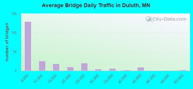
- 2,224,052Total average daily traffic
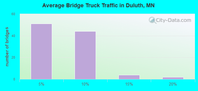
- 81,371Total average daily truck traffic
- National Bridge Inventory (NBI) Registered Bridges for Duluth
- No street view available for this location
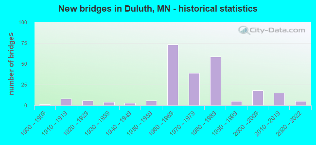
- New bridges - historical statistics
- 11900-1909
- 81910-1919
- 61920-1929
- 41930-1939
- 31940-1949
- 61950-1959
- 731960-1969
- 391970-1979
- 591980-1989
- 51990-1999
- 182000-2009
- 152010-2019
- 52020-2022
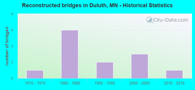
- Reconstructed bridges - Historical Statistics
- 11970-1979
- 61980-1989
- 21990-1999
- 32000-2009
- 12010-2019
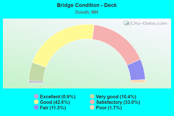
- Bridge Condition - Deck
- 0.9%Excellent
- 10.4%Very good
- 42.6%Good
- 33.0%Satisfactory
- 11.3%Fair
- 1.7%Poor
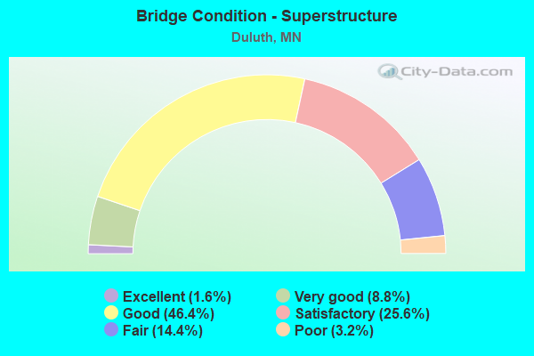
- Bridge Condition - Superstructure
- 1.6%Excellent
- 8.8%Very good
- 46.4%Good
- 25.6%Satisfactory
- 14.4%Fair
- 3.2%Poor
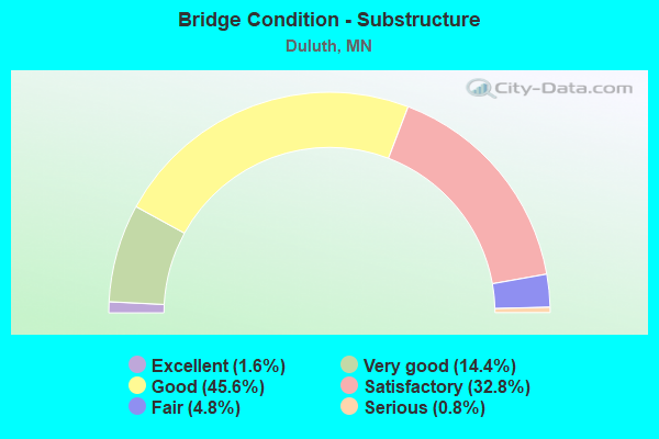
- Bridge Condition - Substructure
- 1.6%Excellent
- 14.4%Very good
- 45.6%Good
- 32.8%Satisfactory
- 4.8%Fair
- 0.8%Serious
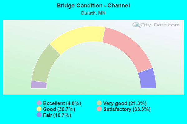
- Bridge Condition - Channel
- 4.0%Excellent
- 21.3%Very good
- 30.7%Good
- 33.3%Satisfactory
- 10.7%Fair
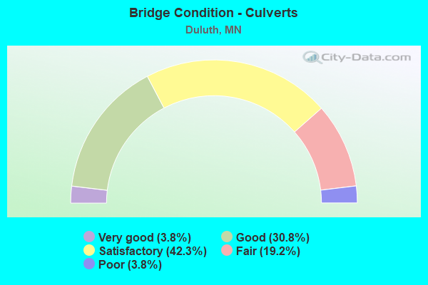
- Bridge Condition - Culverts
- 3.8%Very good
- 30.8%Good
- 42.3%Satisfactory
- 19.2%Fair
- 3.8%Poor
Find on map >> Show street view
Structure Number: 69818N, Location: 0.3 MI SW OF JCT 5TH AVE (Lat: 46.777058, Lng: -92.108331), Route carried "under" structure: State highway 194, Year Built: 1985, Structure Length: 0. m, Average Daily Traffic: 9,250 (year 2004), Truck Traffic: 3%, Features Intersected: SL;LC RR; TH 194 NB, Facility Carried by Structure: I 35
Minimum Vertical Clearance: 6.01m (19.72ft), Kilometerpoint: 0.000, Lanes on structure: 2, Lanes under structure: 2, Material/Design: Prestressed concrete continuous, Design/Construction: Box Beam or Girders - Multiple, Length of Maximum Span: 59.4m (194.9ft)
Find on map >> Show street view
Structure Number: 69818S, Location: 0.3 MI SW OF JCT 5TH AVE (Lat: 46.777142, Lng: -92.108544), Route carried "under" structure: State highway 194, Year Built: 1985, Structure Length: 0. m, Average Daily Traffic: 9,250 (year 2004), Truck Traffic: 3%, Features Intersected: SL;LC RR; TH 194 NB, Facility Carried by Structure: I 35
Minimum Vertical Clearance: 6.31m (20.70ft), Kilometerpoint: 0.000, Lanes on structure: 2, Lanes under structure: 2, Material/Design: Prestressed concrete continuous, Design/Construction: Box Beam or Girders - Multiple, Length of Maximum Span: 50.0m (164.0ft)
Find on map >> Show street view
Structure Number: 69819, Location: 2.3 MI NE OF JCT TH 535 (Lat: 46.788047, Lng: -92.095589), Route carried "under" structure: Interstate 35, Year Built: 1987, Structure Length: 0. m, Average Daily Traffic: 20,400 (year 2019), Truck Traffic: 1%, Features Intersected: I 35, SB RAMP; MICH ST, Facility Carried by Structure: UTILITIES
Minimum Vertical Clearance: 6.01m (19.72ft), Kilometerpoint: 0.000, Lanes on structure: 4, Lanes under structure: 7, Material/Design: Concrete, Design/Construction: Frame, Length of Maximum Span: 23.1m (75.8ft)
Find on map >> Show street view
Structure Number: 69819, Location: 2.3 MI NE OF JCT TH 535 (Lat: 46.788047, Lng: -92.095589), Route carried "under" structure: Interstate 35, Year Built: 1987, Structure Length: 0. m, Average Daily Traffic: 3,000 (year 1994), Features Intersected: I 35, SB RAMP; MICH ST, Facility Carried by Structure: UTILITIES
Minimum Vertical Clearance: 5.18m (16.99ft), Kilometerpoint: 0.000, Lanes on structure: 1, Lanes under structure: 7, Material/Design: Concrete, Design/Construction: Frame, Length of Maximum Span: 23.1m (75.8ft)
Find on map >> Show street view
Structure Number: 69819, Location: 2.3 MI NE OF JCT TH 535 (Lat: 46.788047, Lng: -92.095589), Route carried "under" structure: Ramp Interstate 4325, Year Built: 1987, Structure Length: 0. m, Average Daily Traffic: 4,300 (year 2003), Features Intersected: I 35, SB RAMP; MICH ST, Facility Carried by Structure: UTILITIES
Minimum Vertical Clearance: 5.40m (17.72ft), Kilometerpoint: 0.000, Lanes on structure: 2, Lanes under structure: 7, Material/Design: Concrete, Design/Construction: Frame, Length of Maximum Span: 23.1m (75.8ft)
Find on map >> Show street view
Structure Number: 6982, Location: 2.7 MI NE OF JCT TH 535 (Lat: 46.794225, Lng: -92.088950), Route carried "under" structure: Interstate 35, Year Built: 1983, Structure Length: 0. m, Average Daily Traffic: 20,400 (year 2019), Truck Traffic: 1%, Features Intersected: I 35, Facility Carried by Structure: MSAS 171
Minimum Vertical Clearance: 5.18m (16.99ft), Kilometerpoint: 0.000, Lanes on structure: 4, Lanes under structure: 4, Material/Design: Concrete, Design/Construction: Frame, Length of Maximum Span: 13.4m (44.0ft)
Find on map >> Show street view
Structure Number: 69821, Location: 2.5 MI NE OF JCT TH 535 (Lat: 46.792022, Lng: -92.092072), Route carried "under" structure: Interstate 35, Year Built: 1986, Structure Length: 0. m, Average Daily Traffic: 20,400 (year 2019), Truck Traffic: 1%, Features Intersected: I 35, Facility Carried by Structure: MSAS 171
Minimum Vertical Clearance: 5.33m (17.49ft), Kilometerpoint: 0.000, Lanes on structure: 5, Lanes under structure: 5, Material/Design: Concrete, Design/Construction: Frame, Length of Maximum Span: 15.4m (50.5ft)
Find on map >> Show street view
Structure Number: 69826, Location: 1.5 MI SW OF JCT TH 535 (Lat: 46.748581, Lng: -92.146592), Route carried "under" structure: Interstate 35, Year Built: 1967, Structure Length: 0. m, Average Daily Traffic: 44,000 (year 2019), Truck Traffic: 5%, Features Intersected: I 35, Facility Carried by Structure: MSAS 110
Minimum Vertical Clearance: 5.09m (16.70ft), Kilometerpoint: 0.000, Lanes on structure: 2, Lanes under structure: 4, Material/Design: Steel continuous, Design/Construction: Stringer/Multi-beam, Length of Maximum Span: 14.3m (46.9ft)
Find on map >> Show street view
Structure Number: 69827, Location: 1.3 MI SW OF JCT TH 535 (Lat: 46.750942, Lng: -92.143294), Route carried "under" structure: Interstate 35, Year Built: 1967, Structure Length: 0. m, Average Daily Traffic: 44,000 (year 2019), Truck Traffic: 5%, Features Intersected: I 35; SBOFF RAMP, Facility Carried by Structure: MSAS 109
Minimum Vertical Clearance: 5.03m (16.50ft), Kilometerpoint: 0.000, Lanes on structure: 2, Lanes under structure: 6, Material/Design: Steel continuous, Design/Construction: Stringer/Multi-beam, Length of Maximum Span: 20.7m (67.9ft)
Find on map >> Show street view
Structure Number: 69827, Location: 1.3 MI SW OF JCT TH 535 (Lat: 46.750942, Lng: -92.143294), Route carried "under" structure: Ramp Interstate 4696, Year Built: 1967, Structure Length: 0. m, Average Daily Traffic: 1 (year 2009), Features Intersected: I 35; SBOFF RAMP, Facility Carried by Structure: MSAS 109
Minimum Vertical Clearance: 5.03m (16.50ft), Kilometerpoint: 0.000, Lanes on structure: 2, Lanes under structure: 1, Material/Design: Steel continuous, Design/Construction: Stringer/Multi-beam, Length of Maximum Span: 20.7m (67.9ft)
Find on map >> Show street view
Structure Number: 69833, Location: AT ORE DOCKS (Lat: 46.753650, Lng: -92.137139), Route carried "under" structure: Interstate 35, Year Built: 1966, Structure Length: 0. m, Average Daily Traffic: 44,000 (year 2019), Truck Traffic: 5%, Features Intersected: I 35, Facility Carried by Structure: RAILROAD
Minimum Vertical Clearance: 10.64m (34.91ft), Kilometerpoint: 0.000, Lanes on structure: 4, Lanes under structure: 4, Material/Design: Steel continuous, Design/Construction: Girder and Floorbeam System, Length of Maximum Span: 22.4m (73.5ft)
Find on map >> Show street view
Structure Number: 69838, Location: 3.5 MI N OF JCT TH 535 (Lat: 46.800261, Lng: -92.074500), Route carried "under" structure: Interstate 35, Year Built: 1988, Structure Length: 0. m, Average Daily Traffic: 20,400 (year 2019), Truck Traffic: 1%, Features Intersected: I 35, Facility Carried by Structure: PEDESTRIAN
Minimum Vertical Clearance: 6.68m (21.92ft), Kilometerpoint: 0.000, Lanes on structure: 4, Lanes under structure: 4, Material/Design: Concrete continuous, Design/Construction: Slab, Length of Maximum Span: 14.0m (45.9ft)
Find on map >> Show street view
Structure Number: 69839, Location: AT JCT TH 35 (Lat: 46.776458, Lng: -92.110292), Route carried "under" structure: State highway 194, Year Built: 1969, Structure Length: 0. m, Average Daily Traffic: 12,050 (year 2019), Truck Traffic: 2%, Features Intersected: TH 194 SB
Minimum Vertical Clearance: 5.12m (16.80ft), Kilometerpoint: 0.000, Lanes on structure: 2, Lanes under structure: 2, Material/Design: Steel continuous, Design/Construction: Stringer/Multi-beam, Length of Maximum Span: 39.6m (129.9ft)
Find on map >> Show street view
Structure Number: 6984, Location: 0.2 MI N OF JCT TH 35 (Lat: 46.779525, Lng: -92.107917), Route carried "under" structure: City street 171, Year Built: 1968, Structure Length: 0. m, Average Daily Traffic: 11,960 (year 2019), Truck Traffic: 4%, Features Intersected: SUPERIOR ST(MSAS171), Facility Carried by Structure: MN 194
Minimum Vertical Clearance: 5.43m (17.81ft), Kilometerpoint: 0.000, Lanes on structure: 2, Lanes under structure: 3, Material/Design: Steel continuous, Design/Construction: Stringer/Multi-beam, Length of Maximum Span: 36.0m (118.1ft)
Find on map >> Show street view
Structure Number: 69841A, Location: 3.8 MI NE OF JCT TH 535 (Lat: 46.803653, Lng: -92.067939), Route carried "under" structure: Interstate 35, Year Built: 1988, Structure Length: 0. m, Average Daily Traffic: 18,800 (year 2019), Truck Traffic: 3%, Features Intersected: I 35, SL;LC RR, Facility Carried by Structure: MSAS 152
Minimum Vertical Clearance: 7.10m (23.29ft), Kilometerpoint: 0.000, Lanes on structure: 2, Lanes under structure: 4, Material/Design: Concrete continuous, Design/Construction: Box Beam or Girders - Multiple, Length of Maximum Span: 26.2m (86.0ft)
Find on map >> Show street view
Structure Number: 69843, Location: 4.1 MI NE OF JCT TH 535 (Lat: 46.806706, Lng: -92.062272), Route carried "under" structure: Interstate 35, Year Built: 1990, Structure Length: 0. m, Average Daily Traffic: 18,800 (year 2019), Truck Traffic: 3%, Features Intersected: I 35, Facility Carried by Structure: PEDESTRIAN
Minimum Vertical Clearance: 5.76m (18.90ft), Kilometerpoint: 0.000, Lanes on structure: 4, Lanes under structure: 4, Material/Design: Concrete continuous, Design/Construction: Slab, Length of Maximum Span: 16.7m (54.8ft)
Find on map >> Show street view
Structure Number: 69844, Location: 3.7 MI SW OF JCT TH 535 (Lat: 46.740117, Lng: -92.158447), Route carried "under" structure: City street 1884, Year Built: 2011, Structure Length: 0. m, Features Intersected: RECYCLE WAY, Facility Carried by Structure: I 35
Minimum Vertical Clearance: 5.15m (16.90ft), Kilometerpoint: 0.000, Lanes under structure: 2, Material/Design: Prestressed concrete, Design/Construction: Stringer/Multi-beam, Length of Maximum Span: 39.5m (129.6ft)
Find on map >> Show street view
Structure Number: 69846, Location: 2.1 MI SW OF W JCT TH 2 (Lat: 46.726181, Lng: -92.217078), Route carried "under" structure: Interstate 35, Year Built: 1966, Structure Length: 0. m, Average Daily Traffic: 28,000 (year 2019), Truck Traffic: 5%, Features Intersected: I 35, Facility Carried by Structure: CSAH 14
Minimum Vertical Clearance: 5.12m (16.80ft), Kilometerpoint: 0.000, Lanes on structure: 2, Lanes under structure: 4, Material/Design: Steel continuous, Design/Construction: Stringer/Multi-beam, Length of Maximum Span: 17.7m (58.1ft)
Find on map >> Show street view
Structure Number: 69849, Location: AT JCT TH 2 (Lat: 46.732486, Lng: -92.200661), Route carried "under" structure: Interstate 35, Year Built: 1965, Structure Length: 0. m, Average Daily Traffic: 40,000 (year 2008), Truck Traffic: 6%, Features Intersected: I 35 SB, Facility Carried by Structure: RAILROAD
Minimum Vertical Clearance: 5.24m (17.19ft), Kilometerpoint: 0.000, Lanes on structure: 3, Lanes under structure: 3, Material/Design: Steel, Design/Construction: Girder and Floorbeam System, Length of Maximum Span: 32.0m (105.0ft)
Find on map >> Show street view
Structure Number: 6985, Location: 0.1 MI S OF JCT TH 35 (Lat: 46.731083, Lng: -92.201714), Route carried "under" structure: US 2, Year Built: 1965, Structure Length: 0. m, Average Daily Traffic: 5,200 (year 2019), Truck Traffic: 13%, Features Intersected: US 2 EB, Facility Carried by Structure: RAILROAD
Minimum Vertical Clearance: 5.06m (16.60ft), Kilometerpoint: 0.000, Lanes on structure: 2, Lanes under structure: 2, Material/Design: Steel, Design/Construction: Girder and Floorbeam System, Length of Maximum Span: 19.0m (62.3ft)
Find on map >> Show street view
Structure Number: 69851, Location: 1.0 MI N OF W JCT TH 2 (Lat: 46.738997, Lng: -92.184386), Route carried "under" structure: Ramp Interstate 2195, Year Built: 1965, Structure Length: 0. m, Average Daily Traffic: 3,000 (year 1994), Truck Traffic: 5%, Features Intersected: I 35 NB OFF RAMP, Facility Carried by Structure: I 35
Minimum Vertical Clearance: 4.97m (16.31ft), Kilometerpoint: 0.000, Lanes on structure: 5, Lanes under structure: 1, Material/Design: Steel continuous, Design/Construction: Stringer/Multi-beam, Length of Maximum Span: 19.2m (63.0ft)
Find on map >> Show street view
Structure Number: 69861, Location: AT JCT I 35; US 2 EB (Lat: 46.731242, Lng: -92.202569), Route carried "under" structure: US 2, Year Built: 2009, Structure Length: 0. m, Average Daily Traffic: 5,200 (year 2019), Truck Traffic: 13%, Features Intersected: US 2 EB, Facility Carried by Structure: I 35
Minimum Vertical Clearance: 5.21m (17.09ft), Kilometerpoint: 0.000, Lanes on structure: 5, Lanes under structure: 1, Material/Design: Prestressed concrete, Design/Construction: Stringer/Multi-beam, Length of Maximum Span: 12.8m (42.0ft)
Find on map >> Show street view
Structure Number: 6987, Location: 0.9 MI N OF GARFIELD AVE (Lat: 46.781322, Lng: -92.102753), Route carried "under" structure: City street 118, Year Built: 1966, Structure Length: 0. m, Average Daily Traffic: 3,550 (year 2003), Features Intersected: I 35, ACCES;RR STS; RR, Facility Carried by Structure: MSAS 135
Minimum Vertical Clearance: 5.82m (19.09ft), Kilometerpoint: 0.000, Lanes on structure: 4, Lanes under structure: 4, Material/Design: Steel continuous, Design/Construction: Stringer/Multi-beam, Length of Maximum Span: 25.6m (84.0ft)
Find on map >> Show street view
Structure Number: 6987, Location: 0.9 MI N OF GARFIELD AVE (Lat: 46.781322, Lng: -92.102753), Route carried "under" structure: Interstate 35, Year Built: 1966, Structure Length: 0. m, Average Daily Traffic: 34,500 (year 2019), Truck Traffic: 2%, Features Intersected: I 35, ACCES;RR STS; RR
Minimum Vertical Clearance: 5.52m (18.11ft), Kilometerpoint: 0.000, Lanes on structure: 4, Lanes under structure: 4, Material/Design: Steel continuous, Design/Construction: Stringer/Multi-beam, Length of Maximum Span: 25.6m (84.0ft)
Find on map >> Show street view
Structure Number: 6987, Location: 0.9 MI N OF GARFIELD AVE (Lat: 46.781322, Lng: -92.102753), Route carried "under" structure: City street , Year Built: 1966, Structure Length: 0. m, Average Daily Traffic: 750 (year 1975), Features Intersected: I 35, ACCES;RR STS; RR, Facility Carried by Structure: MSAS 135
Minimum Vertical Clearance: 4.57m (14.99ft), Kilometerpoint: 0.000, Lanes on structure: 4, Lanes under structure: 2, Material/Design: Steel continuous, Design/Construction: Stringer/Multi-beam, Length of Maximum Span: 25.6m (84.0ft)
Find on map >> Show street view
Structure Number: 69879, Location: 3.5 MI SW OF JCT TH 535 (Lat: 46.736089, Lng: -92.174478), Route carried "under" structure: City street 103, Year Built: 1969, Structure Length: 0. m, Average Daily Traffic: 1,550 (year 2003), Features Intersected: CP RAIL, RAMPS; STRS, Facility Carried by Structure: I 35
Minimum Vertical Clearance: 7.59m (24.90ft), Kilometerpoint: 0.000, Lanes on structure: 2, Lanes under structure: 2, Material/Design: Steel continuous, Design/Construction: Stringer/Multi-beam, Length of Maximum Span: 47.9m (157.2ft)
Find on map >> Show street view
Structure Number: 69879, Location: 3.5 MI SW OF JCT TH 535 (Lat: 46.736089, Lng: -92.174478), Route carried "under" structure: City street 104, Year Built: 1969, Structure Length: 0. m, Average Daily Traffic: 2,550 (year 2003), Features Intersected: CP RAIL, RAMPS; STRS, Facility Carried by Structure: I 35
Minimum Vertical Clearance: 6.71m (22.01ft), Kilometerpoint: 0.000, Lanes on structure: 2, Lanes under structure: 4, Material/Design: Steel continuous, Design/Construction: Stringer/Multi-beam, Length of Maximum Span: 47.9m (157.2ft)
Find on map >> Show street view
Structure Number: 69879, Location: 3.5 MI SW OF JCT TH 535 (Lat: 46.736089, Lng: -92.174478), Route carried "under" structure: Ramp Interstate 3971, Year Built: 1969, Structure Length: 0. m, Average Daily Traffic: 3,500 (year 1994), Features Intersected: CP RAIL, RAMPS; STRS, Facility Carried by Structure: I 35
Minimum Vertical Clearance: 6.07m (19.91ft), Kilometerpoint: 0.000, Lanes on structure: 2, Lanes under structure: 1, Material/Design: Steel continuous, Design/Construction: Stringer/Multi-beam, Length of Maximum Span: 47.9m (157.2ft)
Find on map >> Show street view
Structure Number: 69879, Location: 3.5 MI SW OF JCT TH 535 (Lat: 46.736089, Lng: -92.174478), Route carried "under" structure: City street 242, Year Built: 1969, Structure Length: 0. m, Average Daily Traffic: 500 (year 1975), Features Intersected: CP RAIL, RAMPS; STRS, Facility Carried by Structure: I 35
Minimum Vertical Clearance: 7.59m (24.90ft), Kilometerpoint: 0.000, Lanes on structure: 2, Lanes under structure: 2, Material/Design: Steel continuous, Design/Construction: Stringer/Multi-beam, Length of Maximum Span: 47.9m (157.2ft)
Find on map >> Show street view
Structure Number: 69879, Location: 3.5 MI SW OF JCT TH 535 (Lat: 46.736089, Lng: -92.174478), Route carried "under" structure: City street 1904, Year Built: 1969, Structure Length: 0. m, Average Daily Traffic: 750 (year 1975), Features Intersected: CP RAIL, RAMPS; STRS, Facility Carried by Structure: I 35
Minimum Vertical Clearance: 6.40m (21.00ft), Kilometerpoint: 0.000, Lanes on structure: 2, Lanes under structure: 2, Material/Design: Steel continuous, Design/Construction: Stringer/Multi-beam, Length of Maximum Span: 47.9m (157.2ft)
Find on map >> Show street view
Structure Number: 69879, Location: 3.5 MI SW OF JCT TH 535 (Lat: 46.736089, Lng: -92.174478), Route carried "under" structure: City street 107, Year Built: 1969, Structure Length: 0. m, Average Daily Traffic: 6,600 (year 2003), Features Intersected: CP RAIL, RAMPS; STRS, Facility Carried by Structure: I 35
Minimum Vertical Clearance: 5.00m (16.40ft), Kilometerpoint: 0.000, Lanes on structure: 2, Lanes under structure: 2, Material/Design: Steel continuous, Design/Construction: Stringer/Multi-beam, Length of Maximum Span: 47.9m (157.2ft)
Find on map >> Show street view
Structure Number: 69879, Location: 3.5 MI SW OF JCT TH 535 (Lat: 46.736089, Lng: -92.174478), Route carried "under" structure: Ramp Interstate 3971, Year Built: 1969, Structure Length: 0. m, Average Daily Traffic: 7,900 (year 2002), Truck Traffic: 3%, Features Intersected: CP RAIL, RAMPS; STRS, Facility Carried by Structure: I 35
Minimum Vertical Clearance: 5.49m (18.01ft), Kilometerpoint: 0.000, Lanes on structure: 2, Lanes under structure: 1, Material/Design: Steel continuous, Design/Construction: Stringer/Multi-beam, Length of Maximum Span: 47.9m (157.2ft)
Find on map >> Show street view
Structure Number: 69879, Location: 3.5 MI SW OF JCT TH 535 (Lat: 46.736089, Lng: -92.174478), Route carried "under" structure: State highway 23, Year Built: 1969, Structure Length: 0. m, Average Daily Traffic: 14,900 (year 2019), Truck Traffic: 4%, Features Intersected: CP RAIL, RAMPS; STRS, Facility Carried by Structure: I 35
Minimum Vertical Clearance: 7.59m (24.90ft), Kilometerpoint: 0.000, Lanes on structure: 2, Lanes under structure: 4, Material/Design: Steel continuous, Design/Construction: Stringer/Multi-beam, Length of Maximum Span: 47.9m (157.2ft)
Find on map >> Show street view
Structure Number: 69879A, Location: 3.5 MI SW OF JCT TH 535 (Lat: 46.736328, Lng: -92.172914), Route carried "under" structure: City street 107, Year Built: 1969, Structure Length: 0. m, Average Daily Traffic: 11,100 (year 2019), Truck Traffic: 4%, Features Intersected: CP RAIL; STREETS, Facility Carried by Structure: I 35
Minimum Vertical Clearance: 5.00m (16.40ft), Kilometerpoint: 0.000, Lanes on structure: 2, Lanes under structure: 2, Material/Design: Steel continuous, Design/Construction: Stringer/Multi-beam, Length of Maximum Span: 39.7m (130.2ft)
Find on map >> Show street view
Structure Number: 69879A, Location: 3.5 MI SW OF JCT TH 535 (Lat: 46.736328, Lng: -92.172914), Route carried "under" structure: City street 103, Year Built: 1969, Structure Length: 0. m, Average Daily Traffic: 1,550 (year 2003), Features Intersected: CP RAIL; STREETS, Facility Carried by Structure: I 35
Minimum Vertical Clearance: 7.59m (24.90ft), Kilometerpoint: 0.000, Lanes on structure: 2, Lanes under structure: 2, Material/Design: Steel continuous, Design/Construction: Stringer/Multi-beam, Length of Maximum Span: 39.7m (130.2ft)
Find on map >> Show street view
Structure Number: 69879A, Location: 3.5 MI SW OF JCT TH 535 (Lat: 46.736328, Lng: -92.172914), Route carried "under" structure: City street 126, Year Built: 1969, Structure Length: 0. m, Average Daily Traffic: 9,500 (year 2011), Features Intersected: CP RAIL; STREETS, Facility Carried by Structure: I 35
Minimum Vertical Clearance: 5.36m (17.59ft), Kilometerpoint: 0.000, Lanes on structure: 2, Lanes under structure: 4, Material/Design: Steel continuous, Design/Construction: Stringer/Multi-beam, Length of Maximum Span: 39.7m (130.2ft)
Find on map >> Show street view
Structure Number: 69879A, Location: 3.5 MI SW OF JCT TH 535 (Lat: 46.736328, Lng: -92.172914), Route carried "under" structure: City street 104, Year Built: 1969, Structure Length: 0. m, Average Daily Traffic: 2,550 (year 2003), Features Intersected: CP RAIL; STREETS, Facility Carried by Structure: I 35
Minimum Vertical Clearance: 6.71m (22.01ft), Kilometerpoint: 0.000, Lanes on structure: 2, Lanes under structure: 4, Material/Design: Steel continuous, Design/Construction: Stringer/Multi-beam, Length of Maximum Span: 39.7m (130.2ft)
Find on map >> Show street view
Structure Number: 69879A, Location: 3.5 MI SW OF JCT TH 535 (Lat: 46.736328, Lng: -92.172914), Route carried "under" structure: City street 1904, Year Built: 1969, Structure Length: 0. m, Average Daily Traffic: 750 (year 1975), Features Intersected: CP RAIL; STREETS, Facility Carried by Structure: I 35
Minimum Vertical Clearance: 6.40m (21.00ft), Kilometerpoint: 0.000, Lanes on structure: 2, Lanes under structure: 2, Material/Design: Steel continuous, Design/Construction: Stringer/Multi-beam, Length of Maximum Span: 39.7m (130.2ft)
Find on map >> Show street view
Structure Number: 69879A, Location: 3.5 MI SW OF JCT TH 535 (Lat: 46.736328, Lng: -92.172914), Route carried "under" structure: City street 242, Year Built: 1969, Structure Length: 0. m, Average Daily Traffic: 500 (year 1975), Features Intersected: CP RAIL; STREETS, Facility Carried by Structure: I 35
Minimum Vertical Clearance: 7.59m (24.90ft), Kilometerpoint: 0.000, Lanes on structure: 2, Lanes under structure: 2, Material/Design: Steel continuous, Design/Construction: Stringer/Multi-beam, Length of Maximum Span: 39.7m (130.2ft)
Find on map >> Show street view
Structure Number: 69879C, Location: 3.5 MI SW OF JCT TH 535 (Lat: 46.736236, Lng: -92.171761), Route carried "under" structure: City street 242, Year Built: 1969, Structure Length: 0. m, Average Daily Traffic: 500 (year 1975), Features Intersected: 58TH AVE W; 59TH AVE W, Facility Carried by Structure: CON 3537
Minimum Vertical Clearance: 7.59m (24.90ft), Kilometerpoint: 0.000, Lanes on structure: 1, Lanes under structure: 2, Material/Design: Steel continuous, Design/Construction: Stringer/Multi-beam, Length of Maximum Span: 38.1m (125.0ft)
Find on map >> Show street view
Structure Number: 69879C, Location: 3.5 MI SW OF JCT TH 535 (Lat: 46.736236, Lng: -92.171761), Route carried "under" structure: City street 104, Year Built: 1969, Structure Length: 0. m, Average Daily Traffic: 2,550 (year 2003), Features Intersected: 58TH AVE W; 59TH AVE W, Facility Carried by Structure: CON 3537
Minimum Vertical Clearance: 6.71m (22.01ft), Kilometerpoint: 0.000, Lanes on structure: 1, Lanes under structure: 4, Material/Design: Steel continuous, Design/Construction: Stringer/Multi-beam, Length of Maximum Span: 38.1m (125.0ft)
Find on map >> Show street view
Structure Number: 69879D, Location: 3.5 MI SW OF JCT TH 535 (Lat: 46.736258, Lng: -92.168267), Route carried "under" structure: City street 1904, Year Built: 1969, Structure Length: 0. m, Average Daily Traffic: 750 (year 1975), Features Intersected: 57TH AVE W, Facility Carried by Structure: CON 3381
Minimum Vertical Clearance: 6.28m (20.60ft), Kilometerpoint: 0.000, Lanes on structure: 1, Lanes under structure: 2, Material/Design: Steel continuous, Design/Construction: Stringer/Multi-beam, Length of Maximum Span: 27.5m (90.2ft)
Find on map >> Show street view
Structure Number: 69879E, Location: 3.5 MI SW OF JCT TH 535 (Lat: 46.736008, Lng: -92.169175), Route carried "under" structure: City street 1904, Year Built: 1969, Structure Length: 0. m, Average Daily Traffic: 750 (year 1975), Features Intersected: 57TH AVE W, Facility Carried by Structure: CON 723
Minimum Vertical Clearance: 6.40m (21.00ft), Kilometerpoint: 0.000, Lanes on structure: 1, Lanes under structure: 2, Material/Design: Steel continuous, Design/Construction: Stringer/Multi-beam, Length of Maximum Span: 33.3m (109.3ft)
Find on map >> Show street view
Structure Number: 69885, Location: 0.4 MI NE OF GARFIELD AV (Lat: 46.775661, Lng: -92.110419), Route carried "under" structure: Interstate 35, Year Built: 1968, Structure Length: 0. m, Average Daily Traffic: 34,500 (year 2019), Truck Traffic: 2%, Features Intersected: I 35; TWO RAMPS, Facility Carried by Structure: PEDESTRIAN
Minimum Vertical Clearance: 5.33m (17.49ft), Kilometerpoint: 0.000, Lanes on structure: 4, Lanes under structure: 8, Material/Design: Steel continuous, Design/Construction: Stringer/Multi-beam, Length of Maximum Span: 44.7m (146.7ft)
Find on map >> Show street view
Structure Number: 69885, Location: 0.4 MI NE OF GARFIELD AV (Lat: 46.775661, Lng: -92.110419), Route carried "under" structure: State highway 194, Year Built: 1968, Structure Length: 0. m, Average Daily Traffic: 12,050 (year 2019), Truck Traffic: 2%, Features Intersected: I 35; TWO RAMPS, Facility Carried by Structure: PEDESTRIAN
Minimum Vertical Clearance: 5.70m (18.70ft), Kilometerpoint: 0.000, Lanes on structure: 2, Lanes under structure: 8, Material/Design: Steel continuous, Design/Construction: Stringer/Multi-beam, Length of Maximum Span: 44.7m (146.7ft)
Find on map >> Show street view
Structure Number: 69885, Location: 0.4 MI NE OF GARFIELD AV (Lat: 46.775661, Lng: -92.110419), Route carried "under" structure: State highway 194, Year Built: 1968, Structure Length: 0. m, Average Daily Traffic: 9,000 (year 1994), Truck Traffic: 2%, Features Intersected: I 35; TWO RAMPS, Facility Carried by Structure: PEDESTRIAN
Minimum Vertical Clearance: 5.82m (19.09ft), Kilometerpoint: 0.000, Lanes on structure: 2, Lanes under structure: 8, Material/Design: Steel continuous, Design/Construction: Stringer/Multi-beam, Length of Maximum Span: 44.7m (146.7ft)
Find on map >> Show street view
Structure Number: 69888, Location: 5.2 MI SW OF W JCT TH 2 (Lat: 46.704481, Lng: -92.293481), Route carried "under" structure: Interstate 35, Year Built: 1975, Structure Length: 0. m, Average Daily Traffic: 28,393 (year 2019), Truck Traffic: 5%, Features Intersected: I 35, N ; S FRONTAGE RDS, Facility Carried by Structure: RAILROAD
Minimum Vertical Clearance: 5.55m (18.21ft), Kilometerpoint: 0.000, Lanes on structure: 5, Lanes under structure: 9, Material/Design: Steel, Design/Construction: Girder and Floorbeam System, Length of Maximum Span: 38.2m (125.3ft)
Find on map >> Show street view
Structure Number: 69888, Location: 5.2 MI SW OF W JCT TH 2 (Lat: 46.704481, Lng: -92.293481), Route carried "under" structure: County highway 73, Year Built: 1975, Structure Length: 0. m, Average Daily Traffic: 960 (year 2003), Features Intersected: I 35, N ; S FRONTAGE RDS, Facility Carried by Structure: RAILROAD
Minimum Vertical Clearance: 7.01m (23.00ft), Kilometerpoint: 0.000, Lanes on structure: 2, Lanes under structure: 9, Material/Design: Steel, Design/Construction: Girder and Floorbeam System, Length of Maximum Span: 38.2m (125.3ft)
Find on map >> Show street view
Structure Number: 69888, Location: 5.2 MI SW OF W JCT TH 2 (Lat: 46.704481, Lng: -92.293481), Route carried "under" structure: County highway 3, Year Built: 1975, Structure Length: 0. m, Average Daily Traffic: 770 (year 2003), Features Intersected: I 35, N ; S FRONTAGE RDS, Facility Carried by Structure: RAILROAD
Minimum Vertical Clearance: 5.12m (16.80ft), Kilometerpoint: 0.000, Lanes on structure: 2, Lanes under structure: 9, Material/Design: Steel, Design/Construction: Girder and Floorbeam System, Length of Maximum Span: 38.2m (125.3ft)
Find on map >> Show street view
Structure Number: 69889, Location: 5.6 MI SW OF W JCT TH 2 (Lat: 46.703347, Lng: -92.301811), Route carried "under" structure: County highway 61, Year Built: 1974, Structure Length: 0. m, Average Daily Traffic: 2,800 (year 2003), Features Intersected: CSAH 61 AT COUNTY LINE, Facility Carried by Structure: I 35
Minimum Vertical Clearance: 5.06m (16.60ft), Kilometerpoint: 0.000, Lanes on structure: 2, Lanes under structure: 2, Material/Design: Prestressed concrete, Design/Construction: Stringer/Multi-beam, Length of Maximum Span: 27.2m (89.2ft)
Find on map >> Show street view
Structure Number: 6989, Location: 5.6 MI SW OF W JCT TH 2 (Lat: 46.703147, Lng: -92.301444), Route carried "under" structure: County highway 61, Year Built: 1974, Structure Length: 0. m, Average Daily Traffic: 2,800 (year 2003), Features Intersected: CSAH 61 AT COUNTY LINE, Facility Carried by Structure: I 35
Minimum Vertical Clearance: 5.12m (16.80ft), Kilometerpoint: 0.000, Lanes on structure: 2, Lanes under structure: 2, Material/Design: Prestressed concrete, Design/Construction: Stringer/Multi-beam, Length of Maximum Span: 30.5m (100.1ft)
Find on map >> Show street view
Structure Number: 69891, Location: 4.4 MI SW OF W JCT TH 2 (Lat: 46.708156, Lng: -92.279106), Route carried "under" structure: County highway 13, Year Built: 1976, Structure Length: 0. m, Average Daily Traffic: 3,550 (year 2003), Features Intersected: MIDWAY RD(CSAH 13), Facility Carried by Structure: I 35
Minimum Vertical Clearance: 5.21m (17.09ft), Kilometerpoint: 0.000, Lanes on structure: 2, Lanes under structure: 2, Material/Design: Prestressed concrete, Design/Construction: Stringer/Multi-beam, Length of Maximum Span: 27.9m (91.5ft)
Find on map >> Show street view
Structure Number: 69892, Location: 4.4 MI SW OF W JCT TH 2 (Lat: 46.707919, Lng: -92.278961), Route carried "under" structure: County highway 13, Year Built: 1975, Structure Length: 0. m, Average Daily Traffic: 3,550 (year 2003), Features Intersected: MIDWAY RD(CSAH 13), Facility Carried by Structure: I 35
Minimum Vertical Clearance: 4.88m (16.01ft), Kilometerpoint: 0.000, Lanes on structure: 3, Lanes under structure: 2, Material/Design: Prestressed concrete, Design/Construction: Stringer/Multi-beam, Length of Maximum Span: 27.9m (91.5ft)
Find on map >> Show street view
Structure Number: 69909, Location: 0.5 MI S OF JCT I 535 (Lat: 46.759347, Lng: -92.128747), Route carried "under" structure: Interstate 35, Year Built: 2021, Structure Length: 0. m, Average Daily Traffic: 44,000 (year 2019), Truck Traffic: 5%, Features Intersected: I 35, Facility Carried by Structure: 27TH AVE
Minimum Vertical Clearance: 6.71m (22.01ft), Kilometerpoint: 0.000, Lanes under structure: 4, Material/Design: Prestressed concrete, Design/Construction: Stringer/Multi-beam, Length of Maximum Span: 28.0m (91.9ft)
Find on map >> Show street view
Structure Number: 903, Location: 1.3 SE OF JCT TH 35 (Lat: 46.749714, Lng: -92.101203), Route carried "under" structure: City street 690, Year Built: 1961, Structure Length: 0. m, Average Daily Traffic: 3,000 (year 1975), Features Intersected: ST LOUIS R; RR,STREET, Facility Carried by Structure: I 535
Minimum Vertical Clearance: 7.62m (25.00ft), Kilometerpoint: 0.000, Lanes on structure: 4, Lanes under structure: 2, Material/Design: Steel continuous, Design/Construction: Truss - Thru, Length of Maximum Span: 182.9m (600.1ft)
Find on map >> Show street view
Structure Number: 903, Location: 1.3 SE OF JCT TH 35 (Lat: 46.749714, Lng: -92.101203), Route carried "under" structure: City street 149, Year Built: 1961, Structure Length: 0. m, Average Daily Traffic: 2,000 (year 1994), Features Intersected: ST LOUIS R; RR,STREET, Facility Carried by Structure: I 535
Minimum Vertical Clearance: 7.59m (24.90ft), Kilometerpoint: 0.000, Lanes on structure: 4, Lanes under structure: 2, Material/Design: Steel continuous, Design/Construction: Truss - Thru, Length of Maximum Span: 182.9m (600.1ft)
Find on map >> Show street view
Structure Number: 903, Location: 1.3 SE OF JCT TH 35 (Lat: 46.749714, Lng: -92.101203), Route carried "under" structure: City street 729, Year Built: 1961, Structure Length: 0. m, Average Daily Traffic: 1,900 (year 2019), Truck Traffic: 4%, Features Intersected: ST LOUIS R; RR,STREET, Facility Carried by Structure: I 535
Minimum Vertical Clearance: 7.29m (23.92ft), Kilometerpoint: 0.000, Lanes on structure: 4, Lanes under structure: 2, Material/Design: Steel continuous, Design/Construction: Truss - Thru, Length of Maximum Span: 182.9m (600.1ft)
Find on map >> Show street view
Structure Number: L8477, Location: 0.1 MI S OF JCT TH53 (Lat: 46.770594, Lng: -92.139519), Route carried "under" structure: City street 361, Year Built: 1927, Structure Length: 0. m, Average Daily Traffic: 175 (year 1986), Features Intersected: MILLER CREEK; STREET, Facility Carried by Structure: MSAS 203
Minimum Vertical Clearance: 3.63m (11.91ft), Kilometerpoint: 0.000, Lanes on structure: 2, Lanes under structure: 1, Material/Design: Concrete, Design/Construction: Arch - Deck, Length of Maximum Span: 24.2m (79.4ft)