Bridge Statistics for Duluth, Minnesota (MN)
Condition, Traffic, Stress, Structural Evaluation, Project Costs
- National Bridge Inventory (NBI) Statistics
- 242Number of bridges
- 7,287ft / 2,221mTotal length
- $17,706,993,000Total costs
- 2,224,052Total average daily traffic
- 81,371Total average daily truck traffic
- National Bridge Inventory (NBI) Registered Bridges for Duluth
- No street view available for this location
- New bridges - historical statistics
- 11900-1909
- 81910-1919
- 61920-1929
- 41930-1939
- 31940-1949
- 61950-1959
- 731960-1969
- 391970-1979
- 591980-1989
- 51990-1999
- 182000-2009
- 152010-2019
- 52020-2022
- Reconstructed bridges - Historical Statistics
- 11970-1979
- 61980-1989
- 21990-1999
- 32000-2009
- 12010-2019
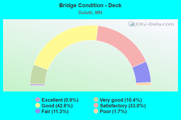
- Bridge Condition - Deck
- 0.9%Excellent
- 10.4%Very good
- 42.6%Good
- 33.0%Satisfactory
- 11.3%Fair
- 1.7%Poor
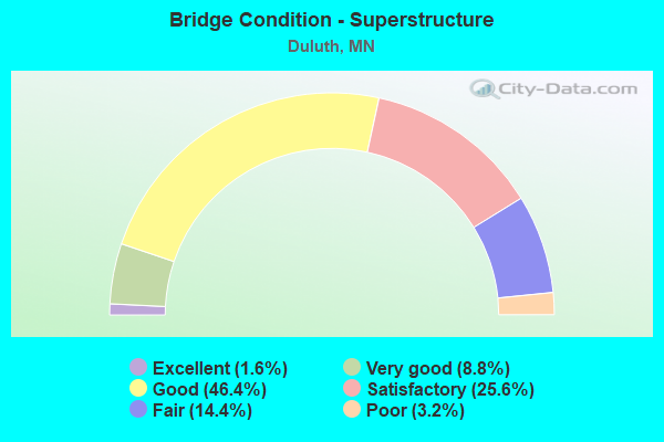
- Bridge Condition - Superstructure
- 1.6%Excellent
- 8.8%Very good
- 46.4%Good
- 25.6%Satisfactory
- 14.4%Fair
- 3.2%Poor
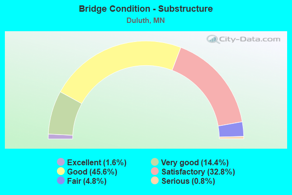
- Bridge Condition - Substructure
- 1.6%Excellent
- 14.4%Very good
- 45.6%Good
- 32.8%Satisfactory
- 4.8%Fair
- 0.8%Serious
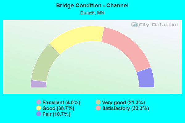
- Bridge Condition - Channel
- 4.0%Excellent
- 21.3%Very good
- 30.7%Good
- 33.3%Satisfactory
- 10.7%Fair
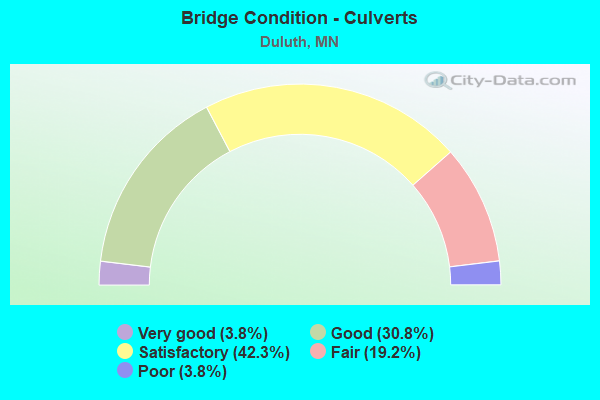
- Bridge Condition - Culverts
- 3.8%Very good
- 30.8%Good
- 42.3%Satisfactory
- 19.2%Fair
- 3.8%Poor
Find on map >> Show street view
Structure Number: 69865, Location: 0.9 MI SW OF JCT TH 535 (Lat: 46.755589, Lng: -92.134094), Route carried "on" structure: Interstate 35, Year Built: 2011, Status: Open, Structure Length: 33.22m (108.99ft), Average Daily Traffic: 22,000 (year 2019), Truck Traffic: 5%, Average Future Daily Traffic: 21,250 (year 2039), Design Load: HL 93, Features Intersected: CN RR
Minimum Vertical Clearance: 30+ m (98+ ft), Kilometerpoint: 0.000, Lanes on structure: 2, Base Highway Network: Yes, Owner: State Highway Agency, Approaching Roadway Width: 12.2m (40.0ft), Material/Design: Prestressed concrete, Design/Construction: Stringer/Multi-beam, Number Of Spans In Main Unit: 11, Length of Maximum Span: 39.6m (129.9ft), Curb-To-Curb Width: 12.8m (42.0ft), Out-to-Out Width: 13.8m (45.3ft)
Condition: Deck: Very good, Superstructure: Very good, Substructure: Very good, Operating Rating: 59.1 metric tons, Method Used To Determine Operating Rating: Load Factor (LF), Inventory Rating: 35.5 metric tons, Method Used To Determine Inventory Rating: Load Factor (LF), Structural Evaluation: Equal to present desirable criteria, Deck Geometry: Equal to present desirable criteria, Underclear: Somewhat better than minimum adequacy, Approach Roadway Alignment: Equal to present desirable criteria, Designated Inspection Frequency: Every 24 months, Inspection Date: April 2021, Deck Structure Type: Concrete Cast-file-Place, Wearing Surface/Protective System: Wearing Surface: Monolithic Concrete, Deck Protection: Epoxy Coated Reinforcing
Find on map >> Show street view
Structure Number: 69866, Location: 0.9 MI SW OF JCT TH 535 (Lat: 46.755817, Lng: -92.133308), Route carried "on" structure: Interstate 35, Year Built: 2011, Status: Open, Structure Length: 35.38m (116.08ft), Average Daily Traffic: 22,000 (year 2019), Truck Traffic: 5%, Average Future Daily Traffic: 21,250 (year 2039), Design Load: HL 93, Features Intersected: CN RR
Minimum Vertical Clearance: 30+ m (98+ ft), Kilometerpoint: 0.000, Lanes on structure: 2, Base Highway Network: Yes, Owner: State Highway Agency, Approaching Roadway Width: 12.2m (40.0ft), Material/Design: Prestressed concrete, Design/Construction: Stringer/Multi-beam, Number Of Spans In Main Unit: 11, Length of Maximum Span: 36.3m (119.1ft), Curb-To-Curb Width: 12.9m (42.3ft), Out-to-Out Width: 13.8m (45.3ft)
Condition: Deck: Very good, Superstructure: Very good, Substructure: Very good, Operating Rating: 48.0 metric tons, Method Used To Determine Operating Rating: Load and Resistance Factor Rating (LRFR) rating reported by rating factor(RF) method using HL-93 loadings, Inventory Rating: 35.6 metric tons, Method Used To Determine Inventory Rating: Load and Resistance Factor Rating (LRFR) rating reported by rating factor(RF) method using HL-93 loadings, Structural Evaluation: Equal to present desirable criteria, Deck Geometry: Superior to present desirable criteria, Underclear: Somewhat better than minimum adequacy, Approach Roadway Alignment: Better than present minimum criteria, Designated Inspection Frequency: Every 24 months, Inspection Date: April 2021, Deck Structure Type: Concrete Cast-file-Place, Wearing Surface/Protective System: Wearing Surface: Monolithic Concrete, Deck Protection: Epoxy Coated Reinforcing
Find on map >> Show street view
Structure Number: 6987, Location: 0.9 MI N OF GARFIELD AVE (Lat: 46.781322, Lng: -92.102753), Route carried "on" structure: City street 135, Year Built: 1966, Status: Open, Structure Length: 21.09m (69.19ft), Average Daily Traffic: 4,350 (year 2017), Average Future Daily Traffic: 4,350 (year 2039), Design Load: HS 20, Features Intersected: I 35, ACCES;RR STS; RR
Minimum Vertical Clearance: 30+ m (98+ ft), Kilometerpoint: 0.000, Lanes on structure: 4, Lanes under structure: 10, Owner: State Highway Agency, Approaching Roadway Width: 14.6m (47.9ft), Material/Design: Steel continuous, Design/Construction: Stringer/Multi-beam, Number Of Spans In Main Unit: 11, Length of Maximum Span: 25.6m (84.0ft), Curb or Sidewalk Widths: Left: 0.0m, Right: 2.5m (8.2ft), Curb-To-Curb Width: 13.4m (44.0ft), Out-to-Out Width: 17.3m (56.8ft)
Condition: Deck: Poor, Superstructure: Satisfactory, Substructure: Satisfactory, Operating Rating: 63.7 metric tons, Method Used To Determine Operating Rating: Load Factor (LF), Inventory Rating: 39.2 metric tons, Method Used To Determine Inventory Rating: Load Factor (LF), Structural Evaluation: Equal to present minimum criteria, Deck Geometry: High priority of replacement, Underclear: High priority of corrective action, Waterway Adequacy: Equal to present desirable criteria, Approach Roadway Alignment: Better than present minimum criteria, Length Of Structure Improvement: 6.43m (21.10ft), Designated Inspection Frequency: Every 12 months, Inspection Date: October 2021, Bridge Improvement Cost: $999,999,000, Roadway Improvement Cost: $53,000,000, Total Project Cost: $807,000,000, Deck Structure Type: Concrete Cast-file-Place, Wearing Surface/Protective System: Wearing Surface: Low Slump Concrete
Find on map >> Show street view
Structure Number: 69870A, Location: 0.1 MI SW OF JCT 5TH AVE (Lat: 46.781206, Lng: -92.103219), Route carried "on" structure: Ramp Interstate 5785, Year Built: 1985, Status: Open, Structure Length: 16.22m (53.22ft), Average Daily Traffic: 2,000 (year 1994), Average Future Daily Traffic: 2,000 (year 2029), Design Load: HS 20, Features Intersected: FILL
Minimum Vertical Clearance: 30+ m (98+ ft), Kilometerpoint: 0.000, Lanes on structure: 1, Base Highway Network: Yes, Owner: State Highway Agency, Approaching Roadway Width: 9.8m (32.2ft), Material/Design: Concrete continuous, Design/Construction: Box Beam or Girders - Multiple, Number Of Spans In Main Unit: 7, Length of Maximum Span: 25.9m (85.0ft), Curb-To-Curb Width: 9.8m (32.2ft), Out-to-Out Width: 10.5m (34.4ft)
Condition: Deck: Good, Superstructure: Good, Substructure: Very good, Operating Rating: 63.7 metric tons, Method Used To Determine Operating Rating: Load Factor (LF), Inventory Rating: 39.2 metric tons, Method Used To Determine Inventory Rating: Load Factor (LF), Structural Evaluation: Better than present minimum criteria, Deck Geometry: Superior to present desirable criteria, Approach Roadway Alignment: Equal to present desirable criteria, Designated Inspection Frequency: Every 24 months, Inspection Date: October 2020, Deck Structure Type: Concrete Cast-file-Place, Wearing Surface/Protective System: Wearing Surface: Low Slump Concrete
Find on map >> Show street view
Structure Number: 69870B, Location: 0.1 MI NE OF JCT 5TH AVE (Lat: 46.781672, Lng: -92.102647), Route carried "on" structure: Ramp Interstate 4690, Year Built: 1986, Status: Open, Structure Length: 11.50m (37.73ft), Average Daily Traffic: 34,500 (year 2019), Truck Traffic: 2%, Average Future Daily Traffic: 2,000 (year 2039), Design Load: HS 20, Features Intersected: FILL
Minimum Vertical Clearance: 30+ m (98+ ft), Kilometerpoint: 0.000, Lanes on structure: 2, Base Highway Network: Yes, Owner: State Highway Agency, Approaching Roadway Width: 9.8m (32.2ft), Material/Design: Concrete continuous, Design/Construction: Box Beam or Girders - Multiple, Number Of Spans In Main Unit: 5, Length of Maximum Span: 23.8m (78.1ft), Curb-To-Curb Width: 9.8m (32.2ft), Out-to-Out Width: 10.5m (34.4ft)
Condition: Deck: Good, Superstructure: Good, Substructure: Good, Operating Rating: 63.7 metric tons, Method Used To Determine Operating Rating: Load Factor (LF), Inventory Rating: 39.2 metric tons, Method Used To Determine Inventory Rating: Load Factor (LF), Structural Evaluation: Better than present minimum criteria, Deck Geometry: Equal to present minimum criteria, Approach Roadway Alignment: Equal to present desirable criteria, Designated Inspection Frequency: Every 24 months, Inspection Date: October 2020, Deck Structure Type: Concrete Cast-file-Place, Wearing Surface/Protective System: Wearing Surface: Low Slump Concrete
Find on map >> Show street view
Structure Number: 69870C, Location: 0.1 MI SW OF JCT 5TH AVE (Lat: 46.781036, Lng: -92.102578), Route carried "on" structure: Ramp Interstate 610, Year Built: 1985, Status: Open, Structure Length: 15.07m (49.44ft), Average Daily Traffic: 2,000 (year 1994), Average Future Daily Traffic: 2,000 (year 2029), Design Load: HS 20, Features Intersected: FILL
Minimum Vertical Clearance: 30+ m (98+ ft), Kilometerpoint: 0.000, Lanes on structure: 1, Base Highway Network: Yes, Owner: State Highway Agency, Approaching Roadway Width: 6.7m (22.0ft), Material/Design: Concrete continuous, Design/Construction: Box Beam or Girders - Multiple, Number Of Spans In Main Unit: 6, Length of Maximum Span: 25.9m (85.0ft), Curb-To-Curb Width: 6.9m (22.6ft), Out-to-Out Width: 8.1m (26.6ft)
Condition: Deck: Good, Superstructure: Good, Substructure: Very good, Operating Rating: 63.7 metric tons, Method Used To Determine Operating Rating: Load Factor (LF), Inventory Rating: 39.2 metric tons, Method Used To Determine Inventory Rating: Load Factor (LF), Structural Evaluation: Better than present minimum criteria, Deck Geometry: Equal to present minimum criteria, Approach Roadway Alignment: Equal to present desirable criteria, Designated Inspection Frequency: Every 24 months, Inspection Date: June 2020, Deck Structure Type: Concrete Cast-file-Place, Wearing Surface/Protective System: Wearing Surface: Low Slump Concrete
Find on map >> Show street view
Structure Number: 69870D, Location: 0.1 MI NE OF JCT 5TH AVE (Lat: 46.781414, Lng: -92.102225), Route carried "on" structure: Ramp Interstate 5786, Year Built: 1986, Status: Open, Structure Length: 10.91m (35.79ft), Average Daily Traffic: 2,000 (year 1994), Average Future Daily Traffic: 2,000 (year 2029), Design Load: HS 20, Features Intersected: FILL
Minimum Vertical Clearance: 30+ m (98+ ft), Kilometerpoint: 0.000, Lanes on structure: 2, Base Highway Network: Yes, Owner: State Highway Agency, Approaching Roadway Width: 9.1m (29.9ft), Material/Design: Concrete continuous, Design/Construction: Box Beam or Girders - Multiple, Number Of Spans In Main Unit: 5, Length of Maximum Span: 23.8m (78.1ft), Curb-To-Curb Width: 9.4m (30.8ft), Out-to-Out Width: 10.5m (34.4ft)
Condition: Deck: Satisfactory, Superstructure: Good, Substructure: Good, Operating Rating: 63.7 metric tons, Method Used To Determine Operating Rating: Load Factor (LF), Inventory Rating: 39.2 metric tons, Method Used To Determine Inventory Rating: Load Factor (LF), Structural Evaluation: Better than present minimum criteria, Deck Geometry: Somewhat better than minimum adequacy, Approach Roadway Alignment: Equal to present desirable criteria, Designated Inspection Frequency: Every 24 months, Inspection Date: October 2020, Deck Structure Type: Concrete Cast-file-Place, Wearing Surface/Protective System: Wearing Surface: Low Slump Concrete
Find on map >> Show street view
Structure Number: 69879, Location: 3.5 MI SW OF JCT TH 535 (Lat: 46.736089, Lng: -92.174478), Route carried "on" structure: Interstate 35, Year Built: 1969, Status: Open, Structure Length: 96.70m (317.26ft), Average Daily Traffic: 17,750 (year 2019), Truck Traffic: 5%, Average Future Daily Traffic: 18,000 (year 2039), Design Load: HS 20+Mod, Features Intersected: CP RAIL, RAMPS; STRS
Minimum Vertical Clearance: 30+ m (98+ ft), Kilometerpoint: 0.000, Lanes on structure: 2, Lanes under structure: 18, Base Highway Network: Yes, Owner: State Highway Agency, Approaching Roadway Width: 11.6m (38.1ft), Skew: 5 degrees, Material/Design: Steel continuous, Design/Construction: Stringer/Multi-beam, Number Of Spans In Main Unit: 22, Number Of Approach Spans: 11, Length of Maximum Span: 47.9m (157.2ft), Curb-To-Curb Width: 11.5m (37.7ft), Out-to-Out Width: 12.6m (41.3ft)
Condition: Deck: Satisfactory, Superstructure: Good, Substructure: Good, Operating Rating: 47.3 metric tons, Method Used To Determine Operating Rating: Load Factor (LF), Inventory Rating: 23.9 metric tons, Method Used To Determine Inventory Rating: Load Factor (LF), Structural Evaluation: Somewhat better than minimum adequacy, Deck Geometry: Somewhat better than minimum adequacy, Underclear: Equal to present desirable criteria, Approach Roadway Alignment: Equal to present desirable criteria, Length Of Structure Improvement: 29.47m (96.69ft), Designated Inspection Frequency: Every 24 months, Inspection Date: August 2020, Bridge Improvement Cost: $999,999,000, Deck Structure Type: Concrete Cast-file-Place, Wearing Surface/Protective System: Wearing Surface: Low Slump Concrete
Find on map >> Show street view
Structure Number: 69879A, Location: 3.5 MI SW OF JCT TH 535 (Lat: 46.736328, Lng: -92.172914), Route carried "on" structure: Interstate 35, Year Built: 1969, Status: Open, Structure Length: 95.15m (312.17ft), Average Daily Traffic: 18,000 (year 2015), Truck Traffic: 5%, Average Future Daily Traffic: 18,000 (year 2039), Design Load: HS 20+Mod, Features Intersected: CP RAIL; STREETS
Minimum Vertical Clearance: 30+ m (98+ ft), Kilometerpoint: 0.000, Lanes on structure: 2, Lanes under structure: 16, Base Highway Network: Yes, Owner: State Highway Agency, Approaching Roadway Width: 11.0m (36.1ft), Skew: 5 degrees, Material/Design: Steel continuous, Design/Construction: Stringer/Multi-beam, Number Of Spans In Main Unit: 23, Number Of Approach Spans: 13, Length of Maximum Span: 39.7m (130.2ft), Curb-To-Curb Width: 11.0m (36.1ft), Out-to-Out Width: 12.5m (41.0ft)
Condition: Deck: Good, Superstructure: Satisfactory, Substructure: Good, Operating Rating: 44.1 metric tons, Method Used To Determine Operating Rating: Load Factor (LF), Inventory Rating: 24.5 metric tons, Method Used To Determine Inventory Rating: Load Factor (LF), Structural Evaluation: Equal to present minimum criteria, Deck Geometry: Somewhat better than minimum adequacy, Underclear: Better than present minimum criteria, Approach Roadway Alignment: Equal to present desirable criteria, Length Of Structure Improvement: 29.02m (95.21ft), Designated Inspection Frequency: Every 24 months, Inspection Date: June 2020, Bridge Improvement Cost: $999,999,000, Deck Structure Type: Concrete Cast-file-Place, Wearing Surface/Protective System: Wearing Surface: Low Slump Concrete
Find on map >> Show street view
Structure Number: 69879B, Location: 3.5 MI SW OF JCT TH 535 (Lat: 46.736256, Lng: -92.173539), Route carried "on" structure: Ramp Interstate 3971, Year Built: 1969, Status: Open, Structure Length: 4.37m (14.34ft), Average Daily Traffic: 3,000 (year 1994), Average Future Daily Traffic: 3,000 (year 2029), Design Load: HS 20+Mod, Features Intersected: FILL
Minimum Vertical Clearance: 30+ m (98+ ft), Kilometerpoint: 0.000, Lanes on structure: 1, Base Highway Network: Yes, Owner: State Highway Agency, Approaching Roadway Width: 7.6m (24.9ft), Skew: 3 degrees, Material/Design: Steel continuous, Design/Construction: Stringer/Multi-beam, Number Of Spans In Main Unit: 2, Length of Maximum Span: 26.7m (87.6ft), Curb-To-Curb Width: 7.5m (24.6ft), Out-to-Out Width: 8.7m (28.5ft)
Condition: Deck: Satisfactory, Superstructure: Good, Substructure: Good, Operating Rating: 54.7 metric tons, Method Used To Determine Operating Rating: Load Factor (LF), Inventory Rating: 32.8 metric tons, Method Used To Determine Inventory Rating: Load Factor (LF), Structural Evaluation: Better than present minimum criteria, Deck Geometry: Better than present minimum criteria, Approach Roadway Alignment: Better than present minimum criteria, Designated Inspection Frequency: Every 24 months, Inspection Date: June 2020, Deck Structure Type: Concrete Cast-file-Place, Wearing Surface/Protective System: Wearing Surface: Low Slump Concrete
Find on map >> Show street view
Structure Number: 69879C, Location: 3.5 MI SW OF JCT TH 535 (Lat: 46.736236, Lng: -92.171761), Route carried "on" structure: Ramp Interstate 3537, Year Built: 1969, Status: Open, Structure Length: 28.98m (95.08ft), Average Daily Traffic: 3,000 (year 1994), Average Future Daily Traffic: 3,000 (year 2029), Design Load: HS 20+Mod, Features Intersected: 58TH AVE W; 59TH AVE W
Minimum Vertical Clearance: 30+ m (98+ ft), Kilometerpoint: 0.000, Lanes on structure: 1, Lanes under structure: 6, Base Highway Network: Yes, Owner: State Highway Agency, Approaching Roadway Width: 7.0m (23.0ft), Material/Design: Steel continuous, Design/Construction: Stringer/Multi-beam, Number Of Spans In Main Unit: 11, Length of Maximum Span: 38.1m (125.0ft), Curb-To-Curb Width: 6.6m (21.7ft), Out-to-Out Width: 7.5m (24.6ft)
Condition: Deck: Good, Superstructure: Good, Substructure: Good, Operating Rating: 42.4 metric tons, Method Used To Determine Operating Rating: Load Factor (LF), Inventory Rating: 26.1 metric tons, Method Used To Determine Inventory Rating: Load Factor (LF), Structural Evaluation: Equal to present minimum criteria, Deck Geometry: Somewhat better than minimum adequacy, Underclear: Superior to present desirable criteria, Approach Roadway Alignment: Equal to present desirable criteria, Designated Inspection Frequency: Every 24 months, Inspection Date: August 2020, Deck Structure Type: Concrete Cast-file-Place, Wearing Surface/Protective System: Wearing Surface: Low Slump Concrete
Find on map >> Show street view
Structure Number: 69879D, Location: 3.5 MI SW OF JCT TH 535 (Lat: 46.736258, Lng: -92.168267), Route carried "on" structure: Ramp Interstate 3381, Year Built: 1969, Status: Open, Structure Length: 15.22m (49.93ft), Average Daily Traffic: 1,750 (year 1994), Average Future Daily Traffic: 1,750 (year 2029), Design Load: HS 20+Mod, Features Intersected: 57TH AVE W
Minimum Vertical Clearance: 30+ m (98+ ft), Kilometerpoint: 0.000, Lanes on structure: 1, Lanes under structure: 2, Base Highway Network: Yes, Owner: State Highway Agency, Approaching Roadway Width: 6.7m (22.0ft), Material/Design: Steel continuous, Design/Construction: Stringer/Multi-beam, Number Of Spans In Main Unit: 6, Length of Maximum Span: 27.5m (90.2ft), Curb-To-Curb Width: 6.6m (21.7ft), Out-to-Out Width: 7.8m (25.6ft)
Condition: Deck: Good, Superstructure: Fair, Substructure: Good, Operating Rating: 49.0 metric tons, Method Used To Determine Operating Rating: Load Factor (LF), Inventory Rating: 29.6 metric tons, Method Used To Determine Inventory Rating: Load Factor (LF), Structural Evaluation: Somewhat better than minimum adequacy, Deck Geometry: Somewhat better than minimum adequacy, Underclear: Superior to present desirable criteria, Approach Roadway Alignment: Equal to present desirable criteria, Length Of Structure Improvement: 4.63m (15.19ft), Designated Inspection Frequency: Every 24 months, Inspection Date: August 2020, Bridge Improvement Cost: $999,999,000, Roadway Improvement Cost: $25,000,000, Total Project Cost: $388,000,000, Deck Structure Type: Concrete Cast-file-Place, Wearing Surface/Protective System: Wearing Surface: Low Slump Concrete
Find on map >> Show street view
Structure Number: 69879E, Location: 3.5 MI SW OF JCT TH 535 (Lat: 46.736008, Lng: -92.169175), Route carried "on" structure: Ramp Interstate 723, Year Built: 1969, Status: Open, Structure Length: 15.94m (52.30ft), Average Daily Traffic: 1,750 (year 1994), Average Future Daily Traffic: 1,750 (year 2029), Design Load: HS 20+Mod, Features Intersected: 57TH AVE W
Minimum Vertical Clearance: 30+ m (98+ ft), Kilometerpoint: 0.000, Lanes on structure: 1, Lanes under structure: 2, Base Highway Network: Yes, Owner: State Highway Agency, Approaching Roadway Width: 6.7m (22.0ft), Material/Design: Steel continuous, Design/Construction: Stringer/Multi-beam, Number Of Spans In Main Unit: 6, Length of Maximum Span: 33.3m (109.3ft), Curb-To-Curb Width: 6.6m (21.7ft), Out-to-Out Width: 7.9m (25.9ft)
Condition: Deck: Satisfactory, Superstructure: Fair, Substructure: Satisfactory, Operating Rating: 47.3 metric tons, Method Used To Determine Operating Rating: Load Factor (LF), Inventory Rating: 27.8 metric tons, Method Used To Determine Inventory Rating: Load Factor (LF), Structural Evaluation: Somewhat better than minimum adequacy, Deck Geometry: Somewhat better than minimum adequacy, Underclear: Superior to present desirable criteria, Approach Roadway Alignment: Equal to present desirable criteria, Length Of Structure Improvement: 4.85m (15.91ft), Designated Inspection Frequency: Every 12 months, Inspection Date: August 2021, Bridge Improvement Cost: $999,999,000, Deck Structure Type: Concrete Cast-file-Place, Wearing Surface/Protective System: Wearing Surface: Low Slump Concrete
Find on map >> Show street view
Structure Number: 69881, Location: AT JCT TH 535; 35 (Lat: 46.766083, Lng: -92.122528), Route carried "on" structure: Interstate 35, Year Built: 1969, Status: Open, Structure Length: 22.12m (72.57ft), Average Daily Traffic: 23,000 (year 2019), Truck Traffic: 4%, Average Future Daily Traffic: 22,250 (year 2039), Design Load: HS 20+Mod, Features Intersected: UNSTABLE MATERIAL
Minimum Vertical Clearance: 6.46m (21.19ft), Kilometerpoint: 0.000, Lanes on structure: 2, Base Highway Network: Yes, Owner: State Highway Agency, Approaching Roadway Width: 11.6m (38.1ft), Material/Design: Steel continuous, Design/Construction: Stringer/Multi-beam, Number Of Spans In Main Unit: 13, Length of Maximum Span: 17.1m (56.1ft), Curb-To-Curb Width: 11.7m (38.4ft), Out-to-Out Width: 12.6m (41.3ft)
Condition: Deck: Good, Superstructure: Satisfactory, Substructure: Satisfactory, Operating Rating: 58.4 metric tons, Method Used To Determine Operating Rating: Load Factor (LF), Inventory Rating: 35.1 metric tons, Method Used To Determine Inventory Rating: Load Factor (LF), Structural Evaluation: Equal to present minimum criteria, Deck Geometry: Equal to present minimum criteria, Approach Roadway Alignment: Equal to present desirable criteria, Length Of Structure Improvement: 6.74m (22.11ft), Designated Inspection Frequency: Every 24 months, Inspection Date: July 2020, Bridge Improvement Cost: $999,999,000, Deck Structure Type: Concrete Cast-file-Place, Wearing Surface/Protective System: Wearing Surface: Low Slump Concrete
Find on map >> Show street view
Structure Number: 69881A, Location: AT JCT TH 535; 35 (Lat: 46.766669, Lng: -92.121825), Route carried "on" structure: Ramp Interstate 4312, Year Built: 1969, Status: Open, Structure Length: 9.19m (30.15ft), Average Daily Traffic: 22,250 (year 2011), Average Future Daily Traffic: 22,250 (year 2039), Design Load: HS 20+Mod, Features Intersected: UNSTABLE MATERIAL
Minimum Vertical Clearance: 30+ m (98+ ft), Kilometerpoint: 0.000, Lanes on structure: 1, Base Highway Network: Yes, Owner: State Highway Agency, Approaching Roadway Width: 6.4m (21.0ft), Material/Design: Steel continuous, Design/Construction: Stringer/Multi-beam, Number Of Spans In Main Unit: 6, Length of Maximum Span: 18.9m (62.0ft), Curb-To-Curb Width: 6.6m (21.7ft), Out-to-Out Width: 7.8m (25.6ft)
Condition: Deck: Satisfactory, Superstructure: Good, Substructure: Satisfactory, Operating Rating: 58.4 metric tons, Method Used To Determine Operating Rating: Load Factor (LF), Inventory Rating: 35.1 metric tons, Method Used To Determine Inventory Rating: Load Factor (LF), Structural Evaluation: Equal to present minimum criteria, Deck Geometry: Somewhat better than minimum adequacy, Approach Roadway Alignment: Equal to present desirable criteria, Designated Inspection Frequency: Every 24 months, Inspection Date: July 2020, Deck Structure Type: Concrete Cast-file-Place, Wearing Surface/Protective System: Wearing Surface: Low Slump Concrete
Find on map >> Show street view
Structure Number: 69881B, Location: AT JCT TH 535; 35 (Lat: 46.768036, Lng: -92.120103), Route carried "on" structure: Ramp Interstate 1762, Year Built: 1969, Status: Open, Structure Length: 2.80m (9.19ft), Average Daily Traffic: 5,625 (year 1994), Truck Traffic: 6%, Average Future Daily Traffic: 5,625 (year 2029), Design Load: HS 20+Mod, Features Intersected: UNSTABLE MATERIAL
Minimum Vertical Clearance: 30+ m (98+ ft), Kilometerpoint: 0.000, Lanes on structure: 1, Base Highway Network: Yes, Owner: State Highway Agency, Approaching Roadway Width: 6.1m (20.0ft), Material/Design: Steel continuous, Design/Construction: Stringer/Multi-beam, Number Of Spans In Main Unit: 2, Length of Maximum Span: 14.7m (48.2ft), Curb-To-Curb Width: 6.6m (21.7ft), Out-to-Out Width: 7.8m (25.6ft)
Condition: Deck: Good, Superstructure: Good, Substructure: Satisfactory, Operating Rating: 58.4 metric tons, Method Used To Determine Operating Rating: Load Factor (LF), Inventory Rating: 35.1 metric tons, Method Used To Determine Inventory Rating: Load Factor (LF), Structural Evaluation: Equal to present minimum criteria, Deck Geometry: Somewhat better than minimum adequacy, Approach Roadway Alignment: Equal to present desirable criteria, Length Of Structure Improvement: 1.04m (3.41ft), Designated Inspection Frequency: Every 24 months, Inspection Date: September 2020, Bridge Improvement Cost: $287,000,000, Roadway Improvement Cost: $5,000,000, Total Project Cost: $79,000,000, Deck Structure Type: Concrete Cast-file-Place, Wearing Surface/Protective System: Wearing Surface: Low Slump Concrete
Find on map >> Show street view
Structure Number: 69881N, Location: AT JCT TH 535; 35 (Lat: 46.768917, Lng: -92.119172), Route carried "on" structure: Interstate 35, Year Built: 1969, Status: Open, Structure Length: 57.70m (189.30ft), Average Daily Traffic: 28,500 (year 2019), Truck Traffic: 4%, Average Future Daily Traffic: 28,500 (year 2039), Design Load: HS 20+Mod, Features Intersected: UNSTABLE MATERIAL
Minimum Vertical Clearance: 30+ m (98+ ft), Kilometerpoint: 0.000, Lanes on structure: 2, Base Highway Network: Yes, Owner: State Highway Agency, Approaching Roadway Width: 11.6m (38.1ft), Material/Design: Steel continuous, Design/Construction: Stringer/Multi-beam, Number Of Spans In Main Unit: 34, Length of Maximum Span: 17.1m (56.1ft), Curb-To-Curb Width: 11.6m (38.1ft), Out-to-Out Width: 12.6m (41.3ft)
Condition: Deck: Fair, Superstructure: Satisfactory, Substructure: Satisfactory, Operating Rating: 58.4 metric tons, Method Used To Determine Operating Rating: Load Factor (LF), Inventory Rating: 35.1 metric tons, Method Used To Determine Inventory Rating: Load Factor (LF), Structural Evaluation: Equal to present minimum criteria, Deck Geometry: Equal to present minimum criteria, Approach Roadway Alignment: Equal to present desirable criteria, Designated Inspection Frequency: Every 24 months, Inspection Date: April 2020, Deck Structure Type: Concrete Cast-file-Place, Wearing Surface/Protective System: Wearing Surface: Low Slump Concrete
Find on map >> Show street view
Structure Number: 69885, Location: 0.4 MI NE OF GARFIELD AV (Lat: 46.775661, Lng: -92.110419), Route carried "on" structure: , Year Built: 1968, Status: Open, Structure Length: 14.39m (47.21ft), Features Intersected: I 35; TWO RAMPS, Facility Carried by Structure: PEDESTRIAN
Lanes under structure: 24, Owner: State Highway Agency, Material/Design: Steel continuous, Design/Construction: Stringer/Multi-beam, Number Of Spans In Main Unit: 4, Length of Maximum Span: 44.7m (146.7ft), Out-to-Out Width: 3.0m (9.8ft)
Condition: Deck: Satisfactory, Superstructure: Satisfactory, Substructure: Good, Underclear: Meets minimum limits, Bridge Posting: Required (Relationship of Operating Rating to Maximum Legal Load: > 39.9% below), Designated Inspection Frequency: Every 24 months, Inspection Date: September 2020, Deck Structure Type: Concrete Cast-file-Place
Find on map >> Show street view
Structure Number: 69887, Location: 0.3 MI N OF GARFIELD AVE (Lat: 46.773408, Lng: -92.113433), Route carried "on" structure: Interstate 35, Year Built: 1970, Status: Open, Structure Length: 64.27m (210.86ft), Average Daily Traffic: 57,000 (year 2019), Truck Traffic: 3%, Average Future Daily Traffic: 57,000 (year 2039), Design Load: HS 20, Features Intersected: UNSTABLE MATERIAL
Minimum Vertical Clearance: 5.33m (17.49ft), Kilometerpoint: 0.000, Lanes on structure: 6, Base Highway Network: Yes, Owner: State Highway Agency, Approaching Roadway Width: 34.1m (111.9ft), Skew: 30 degrees, Material/Design: Prestressed concrete, Design/Construction: Stringer/Multi-beam, Number Of Spans In Main Unit: 38, Length of Maximum Span: 17.1m (56.1ft), Curb-To-Curb Width: 32.3m (106.0ft), Out-to-Out Width: 35.4m (116.1ft)
Condition: Deck: Satisfactory, Superstructure: Satisfactory, Substructure: Satisfactory, Channel: Satisfactory, Operating Rating: 55.3 metric tons, Method Used To Determine Operating Rating: Load Factor (LF), Inventory Rating: 33.1 metric tons, Method Used To Determine Inventory Rating: Load Factor (LF), Structural Evaluation: Equal to present minimum criteria, Deck Geometry: Somewhat better than minimum adequacy, Approach Roadway Alignment: Equal to present desirable criteria, Designated Inspection Frequency: Every 24 months, Inspection Date: June 2021, Deck Structure Type: Concrete Cast-file-Place, Wearing Surface/Protective System: Wearing Surface: Low Slump Concrete
Find on map >> Show street view
Structure Number: 69887A, Location: 0.3 MI N OF GARFIELD AVE (Lat: 46.775733, Lng: -92.110183), Route carried "on" structure: State highway 194, Year Built: 1970, Status: Open, Structure Length: 15.07m (49.44ft), Average Daily Traffic: 7,500 (year 2015), Truck Traffic: 2%, Average Future Daily Traffic: 7,500 (year 2039), Design Load: HS 20, Features Intersected: UNSTABLE MATERIAL
Minimum Vertical Clearance: 5.70m (18.70ft), Kilometerpoint: 0.000, Lanes on structure: 2, Base Highway Network: Yes, Owner: State Highway Agency, Approaching Roadway Width: 8.5m (27.9ft), Material/Design: Prestressed concrete, Design/Construction: Stringer/Multi-beam, Number Of Spans In Main Unit: 7, Number Of Approach Spans: 5, Length of Maximum Span: 14.6m (47.9ft), Curb-To-Curb Width: 8.5m (27.9ft), Out-to-Out Width: 9.8m (32.2ft)
Condition: Deck: Satisfactory, Superstructure: Satisfactory, Substructure: Satisfactory, Operating Rating: 53.7 metric tons, Method Used To Determine Operating Rating: Load Factor (LF), Inventory Rating: 32.2 metric tons, Method Used To Determine Inventory Rating: Load Factor (LF), Structural Evaluation: Equal to present minimum criteria, Deck Geometry: High priority of corrective action, Approach Roadway Alignment: Equal to present desirable criteria, Length Of Structure Improvement: 4.60m (15.09ft), Designated Inspection Frequency: Every 24 months, Inspection Date: September 2020, Bridge Improvement Cost: $999,999,000, Deck Structure Type: Concrete Cast-file-Place, Wearing Surface/Protective System: Wearing Surface: Low Slump Concrete
Find on map >> Show street view
Structure Number: 69887B, Location: 0.3 MI N OF GARFIELD AVE (Lat: 46.776036, Lng: -92.110572), Route carried "on" structure: State highway 194, Year Built: 1970, Status: Open, Structure Length: 3.19m (10.47ft), Average Daily Traffic: 12,050 (year 2019), Truck Traffic: 2%, Average Future Daily Traffic: 9,000 (year 2039), Design Load: HS 20+Mod, Features Intersected: UNSTABLE MATERIAL
Minimum Vertical Clearance: 5.82m (19.09ft), Kilometerpoint: 0.000, Lanes on structure: 2, Base Highway Network: Yes, Owner: State Highway Agency, Approaching Roadway Width: 9.1m (29.9ft), Material/Design: Prestressed concrete, Design/Construction: Stringer/Multi-beam, Number Of Spans In Main Unit: 2, Length of Maximum Span: 17.2m (56.4ft), Curb-To-Curb Width: 9.1m (29.9ft), Out-to-Out Width: 10.4m (34.1ft)
Condition: Deck: Satisfactory, Superstructure: Good, Substructure: Good, Operating Rating: 60.4 metric tons, Method Used To Determine Operating Rating: Load Factor (LF), Inventory Rating: 30.2 metric tons, Method Used To Determine Inventory Rating: Load Factor (LF), Structural Evaluation: Better than present minimum criteria, Deck Geometry: Meets minimum limits, Approach Roadway Alignment: Better than present minimum criteria, Length Of Structure Improvement: 1.22m (4.00ft), Designated Inspection Frequency: Every 24 months, Inspection Date: September 2020, Bridge Improvement Cost: $470,000,000, Deck Structure Type: Concrete Cast-file-Place, Wearing Surface/Protective System: Wearing Surface: Low Slump Concrete
Find on map >> Show street view
Structure Number: 69888, Location: 5.2 MI SW OF W JCT TH 2 (Lat: 46.704481, Lng: -92.293481), Route carried "on" structure: , Year Built: 1975, Status: Open, Structure Length: 15.83m (51.94ft), Features Intersected: I 35, N ; S FRONTAGE RDS, Facility Carried by Structure: RAILROAD
Lanes under structure: 27, Owner: State Highway Agency, Skew: 4 degrees, Material/Design: Steel, Design/Construction: Girder and Floorbeam System, Number Of Spans In Main Unit: 5, Length of Maximum Span: 38.2m (125.3ft), Out-to-Out Width: 5.6m (18.4ft)
Condition: Deck: Good, Superstructure: Good, Substructure: Good, Underclear: Somewhat better than minimum adequacy, Bridge Posting: Required (Relationship of Operating Rating to Maximum Legal Load: > 39.9% below), Designated Inspection Frequency: Every 12 months, Inspection Date: April 2021
Find on map >> Show street view
Structure Number: 69889, Location: 5.6 MI SW OF W JCT TH 2 (Lat: 46.703347, Lng: -92.301811), Route carried "on" structure: Interstate 35, Year Built: 1974, Status: Open, Structure Length: 5.89m (19.32ft), Average Daily Traffic: 14,250 (year 2016), Truck Traffic: 6%, Average Future Daily Traffic: 14,250 (year 2039), Design Load: HS 20, Features Intersected: CSAH 61 AT COUNTY LINE
Minimum Vertical Clearance: 30+ m (98+ ft), Kilometerpoint: 0.000, Lanes on structure: 2, Lanes under structure: 2, Base Highway Network: Yes, Owner: State Highway Agency, Approaching Roadway Width: 11.3m (37.1ft), Skew: 3 degrees, Material/Design: Prestressed concrete, Design/Construction: Stringer/Multi-beam, Number Of Spans In Main Unit: 3, Length of Maximum Span: 27.2m (89.2ft), Curb-To-Curb Width: 12.3m (40.4ft), Out-to-Out Width: 13.4m (44.0ft)
Condition: Deck: Good, Superstructure: Good, Substructure: Good, Operating Rating: 46.9 metric tons, Method Used To Determine Operating Rating: Load Factor (LF), Inventory Rating: 28.1 metric tons, Method Used To Determine Inventory Rating: Load Factor (LF), Structural Evaluation: Better than present minimum criteria, Deck Geometry: Better than present minimum criteria, Underclear: Meets minimum limits, Approach Roadway Alignment: Equal to present desirable criteria, Designated Inspection Frequency: Every 24 months, Inspection Date: August 2020, Deck Structure Type: Concrete Cast-file-Place, Wearing Surface/Protective System: Wearing Surface: Low Slump Concrete
Find on map >> Show street view
Structure Number: 6989, Location: 5.6 MI SW OF W JCT TH 2 (Lat: 46.703147, Lng: -92.301444), Route carried "on" structure: Interstate 35, Year Built: 1974, Status: Open, Structure Length: 6.77m (22.21ft), Average Daily Traffic: 14,586 (year 2019), Truck Traffic: 5%, Average Future Daily Traffic: 14,250 (year 2039), Design Load: HS 20+Mod, Features Intersected: CSAH 61 AT COUNTY LINE
Minimum Vertical Clearance: 30+ m (98+ ft), Kilometerpoint: 0.000, Lanes on structure: 2, Lanes under structure: 2, Base Highway Network: Yes, Owner: State Highway Agency, Approaching Roadway Width: 11.3m (37.1ft), Skew: 4 degrees, Material/Design: Prestressed concrete, Design/Construction: Stringer/Multi-beam, Number Of Spans In Main Unit: 3, Length of Maximum Span: 30.5m (100.1ft), Curb-To-Curb Width: 12.3m (40.4ft), Out-to-Out Width: 13.4m (44.0ft)
Condition: Deck: Good, Superstructure: Good, Substructure: Good, Operating Rating: 66.9 metric tons, Method Used To Determine Operating Rating: Load Factor (LF), Inventory Rating: 40.2 metric tons, Method Used To Determine Inventory Rating: Load Factor (LF), Structural Evaluation: Better than present minimum criteria, Deck Geometry: Better than present minimum criteria, Underclear: Meets minimum limits, Approach Roadway Alignment: Equal to present desirable criteria, Designated Inspection Frequency: Every 24 months, Inspection Date: August 2020, Deck Structure Type: Concrete Cast-file-Place, Wearing Surface/Protective System: Wearing Surface: Low Slump Concrete
Find on map >> Show street view
Structure Number: 69891, Location: 4.4 MI SW OF W JCT TH 2 (Lat: 46.708156, Lng: -92.279106), Route carried "on" structure: Interstate 35, Year Built: 1976, Status: Open, Structure Length: 6.54m (21.46ft), Average Daily Traffic: 14,250 (year 2015), Truck Traffic: 6%, Average Future Daily Traffic: 14,250 (year 2039), Design Load: HS 20+Mod, Features Intersected: MIDWAY RD(CSAH 13)
Minimum Vertical Clearance: 30+ m (98+ ft), Kilometerpoint: 0.000, Lanes on structure: 2, Lanes under structure: 2, Base Highway Network: Yes, Owner: State Highway Agency, Approaching Roadway Width: 12.5m (41.0ft), Skew: 1 degrees, Material/Design: Prestressed concrete, Design/Construction: Stringer/Multi-beam, Number Of Spans In Main Unit: 3, Length of Maximum Span: 27.9m (91.5ft), Curb-To-Curb Width: 12.3m (40.4ft), Out-to-Out Width: 13.5m (44.3ft)
Condition: Deck: Good, Superstructure: Good, Substructure: Good, Operating Rating: 64.0 metric tons, Method Used To Determine Operating Rating: Load Factor (LF), Inventory Rating: 38.2 metric tons, Method Used To Determine Inventory Rating: Load Factor (LF), Structural Evaluation: Better than present minimum criteria, Deck Geometry: Better than present minimum criteria, Underclear: Equal to present desirable criteria, Approach Roadway Alignment: Equal to present desirable criteria, Designated Inspection Frequency: Every 24 months, Inspection Date: August 2020, Deck Structure Type: Concrete Cast-file-Place, Wearing Surface/Protective System: Wearing Surface: Low Slump Concrete
Find on map >> Show street view
Structure Number: 69892, Location: 4.4 MI SW OF W JCT TH 2 (Lat: 46.707919, Lng: -92.278961), Route carried "on" structure: Interstate 35, Year Built: 1975, Status: Open, Structure Length: 6.54m (21.46ft), Average Daily Traffic: 14,197 (year 2019), Truck Traffic: 5%, Average Future Daily Traffic: 10,150 (year 2039), Design Load: HS 20+Mod, Features Intersected: MIDWAY RD(CSAH 13)
Minimum Vertical Clearance: 30+ m (98+ ft), Kilometerpoint: 0.000, Lanes on structure: 3, Lanes under structure: 2, Base Highway Network: Yes, Owner: State Highway Agency, Approaching Roadway Width: 14.0m (45.9ft), Skew: 1 degrees, Material/Design: Prestressed concrete, Design/Construction: Stringer/Multi-beam, Number Of Spans In Main Unit: 3, Length of Maximum Span: 27.9m (91.5ft), Curb-To-Curb Width: 13.7m (44.9ft), Out-to-Out Width: 14.9m (48.9ft)
Condition: Deck: Good, Superstructure: Good, Substructure: Satisfactory, Operating Rating: 65.7 metric tons, Method Used To Determine Operating Rating: Load Factor (LF), Inventory Rating: 32.8 metric tons, Method Used To Determine Inventory Rating: Load Factor (LF), Structural Evaluation: Equal to present minimum criteria, Deck Geometry: Meets minimum limits, Underclear: Better than present minimum criteria, Approach Roadway Alignment: Equal to present desirable criteria, Designated Inspection Frequency: Every 24 months, Inspection Date: August 2020, Deck Structure Type: Concrete Cast-file-Place, Wearing Surface/Protective System: Wearing Surface: Low Slump Concrete
Find on map >> Show street view
Structure Number: 69894, Location: 4.9 MI SW OF W JCT TH 2 (Lat: 46.705325, Lng: -92.286675), Route carried "on" structure: Interstate 35, Year Built: 1975, Status: Open, Structure Length: 7.67m (25.16ft), Average Daily Traffic: 14,197 (year 2019), Truck Traffic: 5%, Average Future Daily Traffic: 14,250 (year 2039), Design Load: HS 20+Mod, Features Intersected: DWP RY (ABAND)
Minimum Vertical Clearance: 30+ m (98+ ft), Kilometerpoint: 0.000, Lanes on structure: 3, Base Highway Network: Yes, Owner: State Highway Agency, Approaching Roadway Width: 14.0m (45.9ft), Skew: 5 degrees, Material/Design: Steel continuous, Design/Construction: Stringer/Multi-beam, Number Of Spans In Main Unit: 3, Length of Maximum Span: 31.7m (104.0ft), Curb-To-Curb Width: 14.3m (46.9ft), Out-to-Out Width: 14.9m (48.9ft)
Condition: Deck: Good, Superstructure: Good, Substructure: Good, Operating Rating: 56.8 metric tons, Method Used To Determine Operating Rating: Load Factor (LF), Inventory Rating: 33.9 metric tons, Method Used To Determine Inventory Rating: Load Factor (LF), Structural Evaluation: Better than present minimum criteria, Deck Geometry: Meets minimum limits, Underclear: Superior to present desirable criteria, Approach Roadway Alignment: Better than present minimum criteria, Length Of Structure Improvement: 2.56m (8.40ft), Designated Inspection Frequency: Every 24 months, Inspection Date: June 2020, Bridge Improvement Cost: $999,999,000, Total Project Cost: $999,999,000, Deck Structure Type: Concrete Cast-file-Place, Wearing Surface/Protective System: Wearing Surface: Low Slump Concrete
Find on map >> Show street view
Structure Number: 69909, Location: 0.5 MI S OF JCT I 535 (Lat: 46.759347, Lng: -92.128747), Route carried "on" structure: City street 115, Year Built: 2021, Status: Open, Structure Length: 5.58m (18.31ft), Average Daily Traffic: 2,050 (year 2018), Average Future Daily Traffic: 7,140 (year 2040), Design Load: HL 93, Features Intersected: I 35, Facility Carried by Structure: 27TH AVE
Minimum Vertical Clearance: 30+ m (98+ ft), Kilometerpoint: 0.000, Lanes on structure: 3, Lanes under structure: 4, Owner: State Highway Agency, Approaching Roadway Width: 12.2m (40.0ft), Material/Design: Prestressed concrete, Design/Construction: Stringer/Multi-beam, Number Of Spans In Main Unit: 2, Length of Maximum Span: 28.0m (91.9ft), Curb or Sidewalk Widths: Left: 2.1m (6.9ft), Right: 2.1m (6.9ft), Curb-To-Curb Width: 12.2m (40.0ft), Out-to-Out Width: 17.4m (57.1ft)
Condition: Deck: Excellent, Superstructure: Excellent, Substructure: Excellent, Operating Rating: 51.5 metric tons, Method Used To Determine Operating Rating: Load and Resistance Factor Rating (LRFR) rating reported by rating factor(RF) method using HL-93 loadings, Inventory Rating: 36.9 metric tons, Method Used To Determine Inventory Rating: Load and Resistance Factor Rating (LRFR) rating reported by rating factor(RF) method using HL-93 loadings, Structural Evaluation: Superior to present desirable criteria, Deck Geometry: Meets minimum limits, Underclear: Better than present minimum criteria, Approach Roadway Alignment: Equal to present desirable criteria, Designated Inspection Frequency: Every 24 months, Inspection Date: June 2021, Deck Structure Type: Concrete Cast-file-Place, Wearing Surface/Protective System: Wearing Surface: Monolithic Concrete, Deck Protection: Epoxy Coated Reinforcing
Find on map >> Show street view
Structure Number: 69A13, Location: 0.1 MI N OF JCT CR282 (Lat: 46.896806, Lng: -91.941911), Route carried "on" structure: County highway 281, Year Built: 2014, Status: Open, Structure Length: 1.27m (4.17ft), Average Daily Traffic: 6 (year 2013), Average Future Daily Traffic: 6 (year 2031), Design Load: HL 93, Features Intersected: TALMADGE RIVER
Minimum Vertical Clearance: 30+ m (98+ ft), Kilometerpoint: 0.000, Lanes on structure: 2, Owner: County Highway Agency, Approaching Roadway Width: 7.3m (24.0ft), Material/Design: Concrete, Design/Construction: Slab, Number Of Spans In Main Unit: 1, Length of Maximum Span: 12.2m (40.0ft), Curb-To-Curb Width: 8.5m (27.9ft), Out-to-Out Width: 9.5m (31.2ft)
Condition: Deck: Good, Superstructure: Very good, Substructure: Very good, Channel: Good, Operating Rating: 44.7 metric tons, Method Used To Determine Operating Rating: Load and Resistance Factor Rating (LRFR) rating reported by rating factor(RF) method using HL-93 loadings, Inventory Rating: 34.7 metric tons, Method Used To Determine Inventory Rating: Load and Resistance Factor Rating (LRFR) rating reported by rating factor(RF) method using HL-93 loadings, Structural Evaluation: Equal to present desirable criteria, Deck Geometry: Better than present minimum criteria, Waterway Adequacy: Equal to present desirable criteria, Approach Roadway Alignment: Better than present minimum criteria, Designated Inspection Frequency: Every 24 months, Inspection Date: June 2020, Deck Structure Type: Concrete Cast-file-Place, Wearing Surface/Protective System: Wearing Surface: Monolithic Concrete, Deck Protection: Epoxy Coated Reinforcing
Find on map >> Show street view
Structure Number: 69A18, Location: 1.2 MI S OF JCT TH63 (Lat: 46.748781, Lng: -92.184831), Route carried "on" structure: County highway 89, Year Built: 2014, Status: Open, Structure Length: 5.67m (18.60ft), Average Daily Traffic: 5,100 (year 2019), Truck Traffic: 9%, Average Future Daily Traffic: 6,014 (year 2039), Design Load: HL 93, Features Intersected: KEENE CREEK
Minimum Vertical Clearance: 30+ m (98+ ft), Kilometerpoint: 0.000, Lanes on structure: 2, Owner: County Highway Agency, Approaching Roadway Width: 12.2m (40.0ft), Skew: 2 degrees, Material/Design: Prestressed concrete, Design/Construction: Stringer/Multi-beam, Number Of Spans In Main Unit: 1, Length of Maximum Span: 54.5m (178.8ft), Curb or Sidewalk Widths: Left: 0.0m, Right: 1.8m (5.9ft), Curb-To-Curb Width: 12.2m (40.0ft), Out-to-Out Width: 15.0m (49.2ft)
Condition: Deck: Good, Superstructure: Very good, Substructure: Very good, Channel: Very good, Operating Rating: 65.1 metric tons, Method Used To Determine Operating Rating: Load and Resistance Factor Rating (LRFR) rating reported by rating factor(RF) method using HL-93 loadings, Inventory Rating: 41.1 metric tons, Method Used To Determine Inventory Rating: Load and Resistance Factor Rating (LRFR) rating reported by rating factor(RF) method using HL-93 loadings, Structural Evaluation: Equal to present desirable criteria, Deck Geometry: Somewhat better than minimum adequacy, Waterway Adequacy: Superior to present desirable criteria, Approach Roadway Alignment: Better than present minimum criteria, Designated Inspection Frequency: Every 24 months, Inspection Date: October 2020, Deck Structure Type: Concrete Cast-file-Place, Wearing Surface/Protective System: Wearing Surface: Low Slump Concrete, Deck Protection: Epoxy Coated Reinforcing
Find on map >> Show street view
Structure Number: 69A45, Location: 0.1 MI W OF JCT CSAH 9 (Lat: 46.836589, Lng: -92.076017), Route carried "on" structure: City street 915, Year Built: 2020, Status: Open, Structure Length: 2.06m (6.76ft), Average Daily Traffic: 33 (year 2019), Average Future Daily Traffic: 33 (year 2039), Design Load: HL 93, Features Intersected: TISCHERS CREEK
Minimum Vertical Clearance: 30+ m (98+ ft), Kilometerpoint: 0.000, Lanes on structure: 2, Owner: City or Municipal Highway Agency, Approaching Roadway Width: 7.9m (25.9ft), Skew: 3 degrees, Material/Design: Prestressed concrete, Design/Construction: Stringer/Multi-beam, Number Of Spans In Main Unit: 1, Length of Maximum Span: 19.8m (65.0ft), Curb-To-Curb Width: 7.9m (25.9ft), Out-to-Out Width: 8.9m (29.2ft)
Condition: Deck: Very good, Superstructure: Very good, Substructure: Very good, Channel: Very good, Operating Rating: 46.7 metric tons, Method Used To Determine Operating Rating: Load and Resistance Factor Rating (LRFR) rating reported by rating factor(RF) method using HL-93 loadings, Inventory Rating: 36.0 metric tons, Method Used To Determine Inventory Rating: Load and Resistance Factor Rating (LRFR) rating reported by rating factor(RF) method using HL-93 loadings, Structural Evaluation: Equal to present desirable criteria, Deck Geometry: Equal to present minimum criteria, Waterway Adequacy: Equal to present desirable criteria, Approach Roadway Alignment: Equal to present desirable criteria, Designated Inspection Frequency: Every 24 months, Inspection Date: October 2020, Deck Structure Type: Concrete Cast-file-Place, Wearing Surface/Protective System: Wearing Surface: Monolithic Concrete, Deck Protection: Epoxy Coated Reinforcing
Find on map >> Show street view
Structure Number: 69A59, Location: 1.3 MI N OF JCT CSAH 10 (Lat: 46.907475, Lng: -92.005469), Route carried "on" structure: County highway 293, Year Built: 2019, Status: Open, Structure Length: 3.38m (11.09ft), Average Daily Traffic: 573 (year 2018), Average Future Daily Traffic: 573 (year 2039), Design Load: HL 93, Features Intersected: LESTER RIVER
Minimum Vertical Clearance: 30+ m (98+ ft), Kilometerpoint: 0.000, Lanes on structure: 2, Owner: County Highway Agency, Approaching Roadway Width: 9.8m (32.2ft), Skew: 2 degrees, Material/Design: Prestressed concrete, Design/Construction: Stringer/Multi-beam, Number Of Spans In Main Unit: 1, Length of Maximum Span: 32.9m (107.9ft), Curb-To-Curb Width: 9.8m (32.2ft), Out-to-Out Width: 10.7m (35.1ft)
Condition: Deck: Very good, Superstructure: Very good, Substructure: Very good, Channel: Very good, Operating Rating: 61.6 metric tons, Method Used To Determine Operating Rating: Load and Resistance Factor Rating (LRFR) rating reported by rating factor(RF) method using HL-93 loadings, Inventory Rating: 42.1 metric tons, Method Used To Determine Inventory Rating: Load and Resistance Factor Rating (LRFR) rating reported by rating factor(RF) method using HL-93 loadings, Structural Evaluation: Equal to present desirable criteria, Deck Geometry: Equal to present minimum criteria, Waterway Adequacy: Superior to present desirable criteria, Approach Roadway Alignment: Better than present minimum criteria, Designated Inspection Frequency: Every 24 months, Inspection Date: June 2020, Deck Structure Type: Concrete Cast-file-Place, Wearing Surface/Protective System: Wearing Surface: Monolithic Concrete, Deck Protection: Epoxy Coated Reinforcing
Find on map >> Show street view
Structure Number: 69A7, Location: 0.1 MI E OF JCT CSAH 50 (Lat: 46.899628, Lng: -91.892792), Route carried "on" structure: County highway 61, Year Built: 2020, Status: Open, Structure Length: 3.77m (12.37ft), Average Daily Traffic: 1,300 (year 2019), Average Future Daily Traffic: 1,633 (year 2040), Design Load: HL 93, Features Intersected: FRENCH RIVER
Minimum Vertical Clearance: 30+ m (98+ ft), Kilometerpoint: 0.000, Lanes on structure: 3, Owner: County Highway Agency, Approaching Roadway Width: 13.4m (44.0ft), Material/Design: Prestressed concrete, Design/Construction: Stringer/Multi-beam, Number Of Spans In Main Unit: 1, Length of Maximum Span: 36.6m (120.1ft), Curb or Sidewalk Widths: Left: 0.0m, Right: 2.4m (7.9ft), Curb-To-Curb Width: 13.4m (44.0ft), Out-to-Out Width: 16.7m (54.8ft)
Condition: Deck: Very good, Superstructure: Very good, Substructure: Very good, Channel: Very good, Operating Rating: 78.7 metric tons, Method Used To Determine Operating Rating: Load and Resistance Factor Rating (LRFR) rating reported by rating factor(RF) method using HL-93 loadings, Inventory Rating: 39.9 metric tons, Method Used To Determine Inventory Rating: Load and Resistance Factor Rating (LRFR) rating reported by rating factor(RF) method using HL-93 loadings, Structural Evaluation: Equal to present desirable criteria, Deck Geometry: Somewhat better than minimum adequacy, Waterway Adequacy: Superior to present desirable criteria, Approach Roadway Alignment: Better than present minimum criteria, Designated Inspection Frequency: Every 24 months, Inspection Date: November 2020, Deck Structure Type: Concrete Cast-file-Place, Wearing Surface/Protective System: Wearing Surface: Monolithic Concrete, Deck Protection: Epoxy Coated Reinforcing
Find on map >> Show street view
Structure Number: 69K12, Location: 0.3 MI N OF JCT TH 23 (Lat: 46.737819, Lng: -92.177483), Route carried "on" structure: City street 103, Year Built: 2014, Status: Open, Structure Length: 0.73m (2.40ft), Average Daily Traffic: 1,836 (year 2012), Truck Traffic: 10%, Average Future Daily Traffic: 2,200 (year 2034), Design Load: HL 93, Features Intersected: KEENE CREEK
Minimum Vertical Clearance: 30+ m (98+ ft), Kilometerpoint: 0.000, Lanes on structure: 2, Owner: City or Municipal Highway Agency, Approaching Roadway Width: 10.4m (34.1ft), Skew: 1 degrees, Material/Design: Concrete, Design/Construction: Culvert, Number Of Spans In Main Unit: 2, Length of Maximum Span: 3.1m (10.2ft), Curb or Sidewalk Widths: Left: 2.7m (8.9ft), Right: 4.0m (13.1ft), Curb-To-Curb Width: 10.4m (34.1ft), Out-to-Out Width: 10.4m (34.1ft)
Condition: Channel: Satisfactory, Culverts: Good, Operating Rating: 42.1 metric tons, Method Used To Determine Operating Rating: Load and Resistance Factor Rating (LRFR) rating reported by rating factor(RF) method using HL-93 loadings, Inventory Rating: 32.4 metric tons, Method Used To Determine Inventory Rating: Load and Resistance Factor Rating (LRFR) rating reported by rating factor(RF) method using HL-93 loadings, Structural Evaluation: Better than present minimum criteria, Deck Geometry: Equal to present minimum criteria, Waterway Adequacy: Equal to present desirable criteria, Approach Roadway Alignment: Equal to present desirable criteria, Designated Inspection Frequency: Every 48 months, Inspection Date: October 2020
Find on map >> Show street view
Structure Number: 69K13, Location: 0.1 MI E OF 63RD AVE W (Lat: 46.737647, Lng: -92.176742), Route carried "on" structure: City street 173, Year Built: 2014, Status: Open, Structure Length: 1.00m (3.28ft), Average Daily Traffic: 320 (year 2013), Truck Traffic: 6%, Average Future Daily Traffic: 384 (year 2034), Design Load: HL 93, Features Intersected: KEENE CREEK
Minimum Vertical Clearance: 30+ m (98+ ft), Kilometerpoint: 0.000, Lanes on structure: 2, Owner: City or Municipal Highway Agency, Approaching Roadway Width: 7.3m (24.0ft), Skew: 4 degrees, Material/Design: Concrete, Design/Construction: Culvert, Number Of Spans In Main Unit: 2, Length of Maximum Span: 4.3m (14.1ft), Curb or Sidewalk Widths: Left: 0.0m, Right: 1.6m (5.2ft)
Condition: Channel: Satisfactory, Culverts: Good, Operating Rating: 42.1 metric tons, Method Used To Determine Operating Rating: Assigned ratings based on Load and Resistance Factor Design (LRFD) reported by rating factor (RF) using HL93 loadings, Inventory Rating: 32.4 metric tons, Method Used To Determine Inventory Rating: Assigned ratings based on Load and Resistance Factor Design (LRFD) reported by rating factor (RF) using HL93 loadings, Structural Evaluation: Better than present minimum criteria, Waterway Adequacy: Equal to present desirable criteria, Approach Roadway Alignment: Equal to present desirable criteria, Designated Inspection Frequency: Every 48 months, Inspection Date: October 2020
Find on map >> Show street view
Structure Number: 69K77, Location: 1.3 MI S OF JCT CSAH 10 (Lat: 46.843558, Lng: -92.050058), Route carried "on" structure: County highway 37, Year Built: 2020, Status: Open, Structure Length: 0.95m (3.12ft), Average Daily Traffic: 5,532 (year 2020), Average Future Daily Traffic: 6,085 (year 2040), Design Load: HL 93, Features Intersected: AMITY CREEK
Minimum Vertical Clearance: 30+ m (98+ ft), Kilometerpoint: 0.000, Lanes on structure: 2, Owner: County Highway Agency, Approaching Roadway Width: 13.4m (44.0ft), Skew: 2 degrees, Material/Design: Concrete, Design/Construction: Culvert, Number Of Spans In Main Unit: 2, Length of Maximum Span: 5.2m (17.1ft)
Condition: Channel: Excellent, Culverts: Very good, Operating Rating: 42.1 metric tons, Method Used To Determine Operating Rating: Assigned ratings based on Load and Resistance Factor Design (LRFD) reported by rating factor (RF) using HL93 loadings, Inventory Rating: 32.4 metric tons, Method Used To Determine Inventory Rating: Assigned ratings based on Load and Resistance Factor Design (LRFD) reported by rating factor (RF) using HL93 loadings, Structural Evaluation: Equal to present desirable criteria, Waterway Adequacy: Superior to present desirable criteria, Approach Roadway Alignment: Equal to present desirable criteria, Designated Inspection Frequency: Every 48 months, Inspection Date: August 2020
Find on map >> Show street view
Structure Number: 69X11, Location: E OF JCT TH 61; 61ST AVE (Lat: 46.837381, Lng: -92.003831), Route carried "on" structure: State highway 61, Year Built: 2013, Status: Open, Structure Length: 0.69m (2.26ft), Average Daily Traffic: 11,100 (year 2019), Truck Traffic: 6%, Average Future Daily Traffic: 10,500 (year 2039), Design Load: HL 93, Features Intersected: LAKEWALK TRAIL
Minimum Vertical Clearance: 30+ m (98+ ft), Kilometerpoint: 0.000, Lanes on structure: 3, Base Highway Network: Yes, Owner: State Highway Agency, Approaching Roadway Width: 14.6m (47.9ft), Skew: 2 degrees, Material/Design: Concrete, Design/Construction: Culvert, Number Of Spans In Main Unit: 1, Length of Maximum Span: 6.9m (22.6ft), Curb-To-Curb Width: 18.3m (60.0ft), Out-to-Out Width: 18.3m (60.0ft)
Condition: Culverts: Good, Operating Rating: 49.0 metric tons, Method Used To Determine Operating Rating: Assigned ratings based on Allowable Stress Design (ASD) reported in metric tons, Inventory Rating: 32.7 metric tons, Method Used To Determine Inventory Rating: Assigned ratings based on Allowable Stress Design (ASD) reported in metric tons, Structural Evaluation: Better than present minimum criteria, Deck Geometry: Superior to present desirable criteria, Approach Roadway Alignment: Equal to present desirable criteria, Designated Inspection Frequency: Every 48 months, Inspection Date: September 2021
Find on map >> Show street view
Structure Number: 69X13, Location: 0.5 MI NW OF JCT TH 35 (Lat: 46.734272, Lng: -92.209358), Route carried "on" structure: US 2, Year Built: 2012, Status: Open, Structure Length: 0.69m (2.26ft), Average Daily Traffic: 10,400 (year 2019), Truck Traffic: 13%, Average Future Daily Traffic: 10,100 (year 2039), Design Load: HL 93, Features Intersected: KINGSBURY CREEK
Minimum Vertical Clearance: 30+ m (98+ ft), Kilometerpoint: 0.000, Lanes on structure: 4, Base Highway Network: Yes, Owner: State Highway Agency, Approaching Roadway Width: 16.5m (54.1ft), Skew: 4 degrees, Material/Design: Concrete, Design/Construction: Culvert, Number Of Spans In Main Unit: 1, Length of Maximum Span: 6.9m (22.6ft)
Condition: Channel: Satisfactory, Culverts: Good, Operating Rating: 42.1 metric tons, Method Used To Determine Operating Rating: Assigned ratings based on Load and Resistance Factor Design (LRFD) reported by rating factor (RF) using HL93 loadings, Inventory Rating: 32.4 metric tons, Method Used To Determine Inventory Rating: Assigned ratings based on Load and Resistance Factor Design (LRFD) reported by rating factor (RF) using HL93 loadings, Structural Evaluation: Better than present minimum criteria, Waterway Adequacy: Better than present minimum criteria, Approach Roadway Alignment: Equal to present desirable criteria, Designated Inspection Frequency: Every 48 months, Inspection Date: September 2021
Find on map >> Show street view
Structure Number: 88552, Location: 0.8 MI SW OF JCT TH 53 (Lat: 46.764653, Lng: -92.133269), Route carried "on" structure: City street 126, Year Built: 1925, Status: Open, Structure Length: 0.76m (2.49ft), Average Daily Traffic: 7,300 (year 2012), Average Future Daily Traffic: 7,300 (year 2039), Features Intersected: MILLER CREEK
Minimum Vertical Clearance: 30+ m (98+ ft), Kilometerpoint: 0.000, Lanes on structure: 2, Owner: City or Municipal Highway Agency, Approaching Roadway Width: 10.4m (34.1ft), Skew: 4 degrees, Material/Design: Concrete, Design/Construction: Culvert, Number Of Spans In Main Unit: 1, Length of Maximum Span: 6.1m (20.0ft), Curb or Sidewalk Widths: Left: 1.5m (4.9ft), Right: 1.5m (4.9ft), Curb-To-Curb Width: 10.4m (34.1ft), Out-to-Out Width: 21.3m (69.9ft)
Condition: Channel: Satisfactory, Culverts: Satisfactory, Operating Rating: 42.4 metric tons, Method Used To Determine Operating Rating: Field evaluation and documented engineering judgment, Inventory Rating: 32.7 metric tons, Method Used To Determine Inventory Rating: Field evaluation and documented engineering judgment, Structural Evaluation: Equal to present minimum criteria, Deck Geometry: Meets minimum limits, Waterway Adequacy: Equal to present desirable criteria, Approach Roadway Alignment: Equal to present desirable criteria, Length Of Structure Improvement: 0.37m (1.21ft), Designated Inspection Frequency: Every 24 months, Inspection Date: October 2021, Bridge Improvement Cost: $154,000,000
Find on map >> Show street view
Structure Number: 903, Location: 1.3 SE OF JCT TH 35 (Lat: 46.749714, Lng: -92.101203), Route carried "on" structure: Interstate 535, Year Built: 1961, Year Reconstructed: 1993, Status: Posted for load, Structure Length: 243.23m (798.00ft), Average Daily Traffic: 33,021 (year 2019), Truck Traffic: 6%, Average Future Daily Traffic: 32,500 (year 2039), Design Load: HS 20, Features Intersected: ST LOUIS R; RR,STREET
Minimum Vertical Clearance: 5.82m (19.09ft), Kilometerpoint: 0.000, Lanes on structure: 4, Lanes under structure: 6, Base Highway Network: Yes, Owner: State Highway Agency, Approaching Roadway Width: 17.7m (58.1ft), Skew: 30 degrees, Navigation Control: Yes ( Vertical Clearance: 36.6m (120.1ft), Horizontal Clearance: 152.4m (500.0ft)), Material/Design: Steel continuous, Design/Construction: Truss - Thru, Number Of Spans In Main Unit: 3, Number Of Approach Spans: 49, Length of Maximum Span: 182.9m (600.1ft), Curb-To-Curb Width: 17.9m (58.7ft), Out-to-Out Width: 19.4m (63.6ft)
Condition: Deck: Satisfactory, Superstructure: Poor, Substructure: Satisfactory, Channel: Good, Operating Rating: 26.9 metric tons, Method Used To Determine Operating Rating: Load and Resistance Factor Rating (LRFR) rating reported by rating factor(RF) method using HL-93 loadings, Inventory Rating: 20.7 metric tons, Method Used To Determine Inventory Rating: Load and Resistance Factor Rating (LRFR) rating reported by rating factor(RF) method using HL-93 loadings, Structural Evaluation: Meets minimum limits, Deck Geometry: Meets minimum limits, Underclear: Better than present minimum criteria, Waterway Adequacy: Equal to present desirable criteria, Approach Roadway Alignment: Equal to present desirable criteria, Length Of Structure Improvement: 74.13m (243.21ft), Designated Inspection Frequency: Every 12 months, Critical Feature Inspection Frequency: Every 24 months, Underwater Inspection Frequency: Every 60 months, Other Special Inspection Frequency: Every 48 months, Inspection Date: July 2021, Critical Feature Inspection Date: July 2021, Underwater Inspection Date: August 2021, Other Special Inspection Date: July 2019, Bridge Improvement Cost: $999,999,000, Deck Structure Type: Concrete Cast-file-Place, Wearing Surface/Protective System: Wearing Surface: Low Slump Concrete, Deck Protection: Epoxy Coated Reinforcing
Find on map >> Show street view
Structure Number: 91069, Location: 0.1 MI S OF JCT TH 535 (Lat: 46.764122, Lng: -92.124206), Route carried "on" structure: Interstate 35, Year Built: 1969, Status: Open, Structure Length: 0.77m (2.53ft), Average Daily Traffic: 46,000 (year 2019), Truck Traffic: 3%, Average Future Daily Traffic: 44,500 (year 2039), Features Intersected: MILLER CREEK
Minimum Vertical Clearance: 30+ m (98+ ft), Kilometerpoint: 0.000, Lanes on structure: 4, Base Highway Network: Yes, Owner: State Highway Agency, Approaching Roadway Width: 43.9m (144.0ft), Skew: 13 degrees, Material/Design: Concrete, Design/Construction: Culvert, Number Of Spans In Main Unit: 2, Length of Maximum Span: 3.6m (11.8ft)
Condition: Channel: Satisfactory, Culverts: Satisfactory, Operating Rating: 39.2 metric tons, Method Used To Determine Operating Rating: Assigned ratings based on Allowable Stress Design (ASD) reported in metric tons, Inventory Rating: 29.4 metric tons, Method Used To Determine Inventory Rating: Assigned ratings based on Allowable Stress Design (ASD) reported in metric tons, Structural Evaluation: Equal to present minimum criteria, Waterway Adequacy: Better than present minimum criteria, Approach Roadway Alignment: Equal to present desirable criteria, Designated Inspection Frequency: Every 24 months, Underwater Inspection Frequency: Every 60 months, Inspection Date: July 2020, Underwater Inspection Date: September 2016