Bridge Statistics for Duluth, Minnesota (MN)
Condition, Traffic, Stress, Structural Evaluation, Project Costs
- National Bridge Inventory (NBI) Statistics
- 242Number of bridges
- 7,287ft / 2,221mTotal length
- $17,706,993,000Total costs
- 2,224,052Total average daily traffic
- 81,371Total average daily truck traffic
- National Bridge Inventory (NBI) Registered Bridges for Duluth
- No street view available for this location
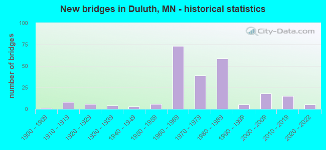
- New bridges - historical statistics
- 11900-1909
- 81910-1919
- 61920-1929
- 41930-1939
- 31940-1949
- 61950-1959
- 731960-1969
- 391970-1979
- 591980-1989
- 51990-1999
- 182000-2009
- 152010-2019
- 52020-2022
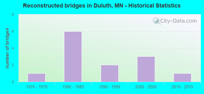
- Reconstructed bridges - Historical Statistics
- 11970-1979
- 61980-1989
- 21990-1999
- 32000-2009
- 12010-2019
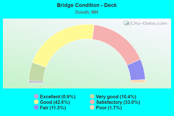
- Bridge Condition - Deck
- 0.9%Excellent
- 10.4%Very good
- 42.6%Good
- 33.0%Satisfactory
- 11.3%Fair
- 1.7%Poor
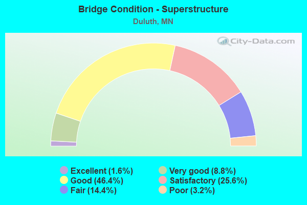
- Bridge Condition - Superstructure
- 1.6%Excellent
- 8.8%Very good
- 46.4%Good
- 25.6%Satisfactory
- 14.4%Fair
- 3.2%Poor
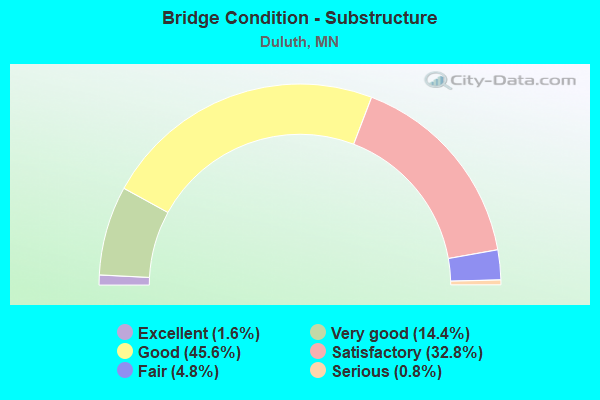
- Bridge Condition - Substructure
- 1.6%Excellent
- 14.4%Very good
- 45.6%Good
- 32.8%Satisfactory
- 4.8%Fair
- 0.8%Serious
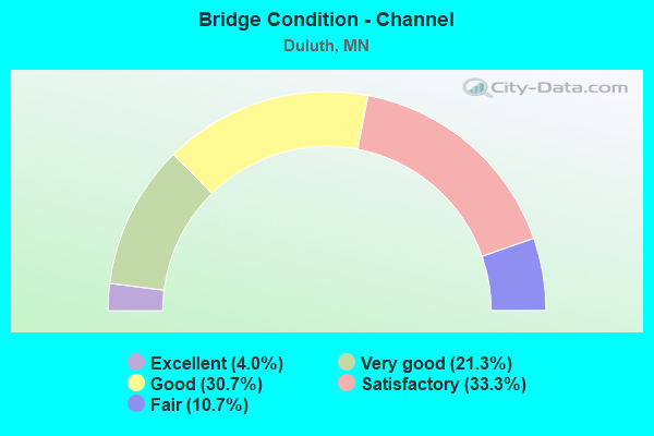
- Bridge Condition - Channel
- 4.0%Excellent
- 21.3%Very good
- 30.7%Good
- 33.3%Satisfactory
- 10.7%Fair
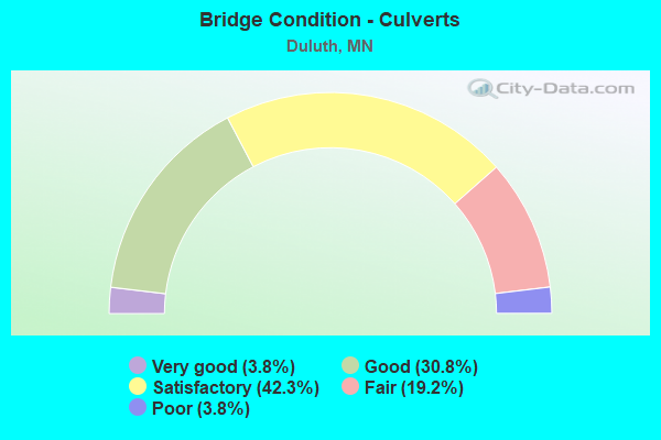
- Bridge Condition - Culverts
- 3.8%Very good
- 30.8%Good
- 42.3%Satisfactory
- 19.2%Fair
- 3.8%Poor
Find on map >> Show street view
Structure Number: 91293, Location: 0.1 MI W OF JCT TH 53 (Lat: 46.807575, Lng: -92.165147), Route carried "on" structure: County highway 6, Year Built: 1975, Year Reconstructed: 2008, Status: Open, Structure Length: 0.69m (2.26ft), Average Daily Traffic: 9,600 (year 2015), Average Future Daily Traffic: 9,600 (year 2039), Design Load: HS 20, Features Intersected: MILLERS CREEK
Minimum Vertical Clearance: 30+ m (98+ ft), Kilometerpoint: 0.000, Lanes on structure: 4, Owner: County Highway Agency, Approaching Roadway Width: 14.6m (47.9ft), Material/Design: Concrete, Design/Construction: Culvert, Number Of Spans In Main Unit: 2, Length of Maximum Span: 3.0m (9.8ft)
Condition: Channel: Good, Culverts: Satisfactory, Operating Rating: 58.8 metric tons, Method Used To Determine Operating Rating: Field evaluation and documented engineering judgment, Inventory Rating: 39.2 metric tons, Method Used To Determine Inventory Rating: Field evaluation and documented engineering judgment, Structural Evaluation: Equal to present minimum criteria, Waterway Adequacy: Equal to present desirable criteria, Approach Roadway Alignment: Equal to present desirable criteria, Length Of Structure Improvement: 0.34m (1.12ft), Designated Inspection Frequency: Every 48 months, Inspection Date: September 2020, Bridge Improvement Cost: $72,000,000
Find on map >> Show street view
Structure Number: 91294, Location: 0.1 MI S OF JCT CSAH 6 (Lat: 46.805725, Lng: -92.164817), Route carried "on" structure: City street 178, Year Built: 1975, Status: Open, Structure Length: 0.69m (2.26ft), Average Daily Traffic: 5,800 (year 2016), Average Future Daily Traffic: 5,800 (year 2039), Design Load: HS 20, Features Intersected: MILLER CREEK
Minimum Vertical Clearance: 30+ m (98+ ft), Kilometerpoint: 0.000, Lanes on structure: 4, Owner: City or Municipal Highway Agency, Approaching Roadway Width: 14.6m (47.9ft), Skew: 4 degrees, Material/Design: Concrete, Design/Construction: Culvert, Number Of Spans In Main Unit: 2, Length of Maximum Span: 3.0m (9.8ft), Curb or Sidewalk Widths: Left: 1.5m (4.9ft), Right: 0.0m
Condition: Channel: Fair, Culverts: Satisfactory, Operating Rating: 39.2 metric tons, Method Used To Determine Operating Rating: Field evaluation and documented engineering judgment, Inventory Rating: 29.4 metric tons, Method Used To Determine Inventory Rating: Field evaluation and documented engineering judgment, Structural Evaluation: Equal to present minimum criteria, Waterway Adequacy: Better than present minimum criteria, Approach Roadway Alignment: Equal to present minimum criteria, Length Of Structure Improvement: 0.34m (1.12ft), Designated Inspection Frequency: Every 24 months, Inspection Date: October 2020, Bridge Improvement Cost: $72,000,000
Find on map >> Show street view
Structure Number: 91675, Location: 0.1 MI N OF JCT TH 53 (Lat: 46.815569, Lng: -92.174781), Route carried "on" structure: County highway 91, Year Built: 1980, Status: Open, Structure Length: 0.96m (3.15ft), Average Daily Traffic: 10,051 (year 2019), Truck Traffic: 4%, Average Future Daily Traffic: 10,000 (year 2039), Design Load: HS 20, Features Intersected: MILLERS CREEK
Minimum Vertical Clearance: 30+ m (98+ ft), Kilometerpoint: 0.000, Lanes on structure: 2, Owner: County Highway Agency, Approaching Roadway Width: 13.4m (44.0ft), Skew: 2 degrees, Material/Design: Concrete, Design/Construction: Culvert, Number Of Spans In Main Unit: 2, Length of Maximum Span: 3.7m (12.1ft)
Condition: Channel: Fair, Culverts: Satisfactory, Operating Rating: 53.9 metric tons, Method Used To Determine Operating Rating: Assigned ratings based on Allowable Stress Design (ASD) reported in metric tons, Inventory Rating: 35.9 metric tons, Method Used To Determine Inventory Rating: Assigned ratings based on Allowable Stress Design (ASD) reported in metric tons, Structural Evaluation: Equal to present minimum criteria, Waterway Adequacy: Better than present minimum criteria, Approach Roadway Alignment: Equal to present desirable criteria, Designated Inspection Frequency: Every 24 months, Underwater Inspection Frequency: Every 60 months, Inspection Date: July 2020, Underwater Inspection Date: September 2021
Find on map >> Show street view
Structure Number: 9255, Location: 0.2 MI E OF CENTRAL AVE (Lat: 46.730617, Lng: -92.162667), Route carried "on" structure: City street 108, Year Built: 1959, Status: Open, Structure Length: 4.75m (15.58ft), Average Daily Traffic: 1,300 (year 2014), Average Future Daily Traffic: 1,300 (year 2039), Design Load: HS 25 or greater, Features Intersected: BNSF RR
Minimum Vertical Clearance: 30+ m (98+ ft), Kilometerpoint: 0.000, Lanes on structure: 2, Owner: City or Municipal Highway Agency, Approaching Roadway Width: 11.0m (36.1ft), Material/Design: Concrete continuous, Design/Construction: Slab, Number Of Spans In Main Unit: 4, Length of Maximum Span: 11.6m (38.1ft), Curb or Sidewalk Widths: Left: 1.5m (4.9ft), Right: 0.0m, Curb-To-Curb Width: 11.0m (36.1ft), Out-to-Out Width: 13.7m (44.9ft)
Condition: Deck: Good, Superstructure: Satisfactory, Substructure: Satisfactory, Operating Rating: 91.4 metric tons, Method Used To Determine Operating Rating: Load Factor (LF), Inventory Rating: 54.5 metric tons, Method Used To Determine Inventory Rating: Load Factor (LF), Structural Evaluation: Equal to present minimum criteria, Deck Geometry: Equal to present minimum criteria, Underclear: Meets minimum limits, Approach Roadway Alignment: Equal to present minimum criteria, Designated Inspection Frequency: Every 24 months, Inspection Date: October 2021, Deck Structure Type: Concrete Cast-file-Place, Wearing Surface/Protective System: Wearing Surface: Low Slump Concrete, Deck Protection: Epoxy Coated Reinforcing
Find on map >> Show street view
Structure Number: 92627, Location: 0.2 MI W OF JCT CR281 (Lat: 46.938264, Lng: -91.942825), Route carried "on" structure: County highway 43, Year Built: 1970, Status: Open, Structure Length: 0.66m (2.17ft), Average Daily Traffic: 1,150 (year 2015), Average Future Daily Traffic: 1,150 (year 2039), Design Load: HS 20, Features Intersected: FRENCH RIVER
Minimum Vertical Clearance: 30+ m (98+ ft), Kilometerpoint: 0.000, Lanes on structure: 2, Owner: County Highway Agency, Approaching Roadway Width: 11.0m (36.1ft), Material/Design: Concrete, Design/Construction: Culvert, Number Of Spans In Main Unit: 1, Length of Maximum Span: 6.1m (20.0ft)
Condition: Channel: Satisfactory, Culverts: Satisfactory, Operating Rating: 53.9 metric tons, Method Used To Determine Operating Rating: Assigned ratings based on Allowable Stress Design (ASD) reported in metric tons, Inventory Rating: 35.9 metric tons, Method Used To Determine Inventory Rating: Assigned ratings based on Allowable Stress Design (ASD) reported in metric tons, Structural Evaluation: Equal to present minimum criteria, Waterway Adequacy: Equal to present desirable criteria, Approach Roadway Alignment: Better than present minimum criteria, Designated Inspection Frequency: Every 48 months, Inspection Date: November 2020
Find on map >> Show street view
Structure Number: 93512, Location: 0.1 MI W OF JCT CR 293 (Lat: 46.894889, Lng: -92.005547), Route carried "on" structure: County highway 259, Year Built: 1980, Status: Open, Structure Length: 0.81m (2.66ft), Average Daily Traffic: 5 (year 2011), Average Future Daily Traffic: 5 (year 2039), Design Load: HS 20, Features Intersected: STREAM
Minimum Vertical Clearance: 30+ m (98+ ft), Kilometerpoint: 0.000, Lanes on structure: 2, Owner: County Highway Agency, Approaching Roadway Width: 8.5m (27.9ft), Material/Design: Concrete, Design/Construction: Culvert, Number Of Spans In Main Unit: 2, Length of Maximum Span: 2.9m (9.5ft)
Condition: Channel: Good, Culverts: Good, Operating Rating: 53.9 metric tons, Method Used To Determine Operating Rating: Assigned ratings based on Allowable Stress Design (ASD) reported in metric tons, Inventory Rating: 35.9 metric tons, Method Used To Determine Inventory Rating: Assigned ratings based on Allowable Stress Design (ASD) reported in metric tons, Structural Evaluation: Better than present minimum criteria, Waterway Adequacy: Equal to present desirable criteria, Approach Roadway Alignment: Equal to present desirable criteria, Designated Inspection Frequency: Every 48 months, Inspection Date: November 2020
Find on map >> Show street view
Structure Number: 93586, Location: 0.5 MI N OF JCT CR 259 (Lat: 46.900253, Lng: -92.026672), Route carried "on" structure: County highway 245, Year Built: 1982, Status: Posted for load, Structure Length: 0.91m (2.99ft), Average Daily Traffic: 110 (year 2011), Average Future Daily Traffic: 110 (year 2039), Design Load: H 15, Features Intersected: STREAM
Minimum Vertical Clearance: 30+ m (98+ ft), Kilometerpoint: 0.000, Lanes on structure: 2, Owner: County Highway Agency, Approaching Roadway Width: 7.0m (23.0ft), Material/Design: Steel, Design/Construction: Stringer/Multi-beam, Number Of Spans In Main Unit: 1, Length of Maximum Span: 8.7m (28.5ft), Curb-To-Curb Width: 7.3m (24.0ft), Out-to-Out Width: 8.7m (28.5ft)
Condition: Deck: Satisfactory, Superstructure: Fair, Substructure: Satisfactory, Channel: Satisfactory, Operating Rating: 28.7 metric tons, Method Used To Determine Operating Rating: Load Factor (LF), Inventory Rating: 21.5 metric tons, Method Used To Determine Inventory Rating: Load Factor (LF), Structural Evaluation: Somewhat better than minimum adequacy, Deck Geometry: Somewhat better than minimum adequacy, Waterway Adequacy: Equal to present desirable criteria, Approach Roadway Alignment: Equal to present desirable criteria, Bridge Posting: Required (Relationship of Operating Rating to Maximum Legal Load: 30.0 - 39.9% below), Designated Inspection Frequency: Every 24 months, Inspection Date: July 2020, Deck Structure Type: Wood or Timber, Wearing Surface/Protective System: Wearing Surface: Bituminous
Find on map >> Show street view
Structure Number: 9605, Location: 0.4 MI N OF JCT CSAH 10 (Lat: 46.894281, Lng: -92.005378), Route carried "on" structure: County highway 293, Year Built: 1984, Status: Open, Structure Length: 1.02m (3.35ft), Average Daily Traffic: 540 (year 2011), Average Future Daily Traffic: 540 (year 2039), Design Load: HS 20, Features Intersected: STREAM
Minimum Vertical Clearance: 30+ m (98+ ft), Kilometerpoint: 0.000, Lanes on structure: 2, Owner: County Highway Agency, Approaching Roadway Width: 8.8m (28.9ft), Skew: 3 degrees, Material/Design: Concrete, Design/Construction: Culvert, Number Of Spans In Main Unit: 2, Length of Maximum Span: 3.4m (11.2ft)
Condition: Channel: Good, Culverts: Satisfactory, Operating Rating: 53.9 metric tons, Method Used To Determine Operating Rating: Assigned ratings based on Allowable Stress Design (ASD) reported in metric tons, Inventory Rating: 35.9 metric tons, Method Used To Determine Inventory Rating: Assigned ratings based on Allowable Stress Design (ASD) reported in metric tons, Structural Evaluation: Equal to present minimum criteria, Waterway Adequacy: Equal to present desirable criteria, Approach Roadway Alignment: Better than present minimum criteria, Designated Inspection Frequency: Every 48 months, Inspection Date: November 2020
Find on map >> Show street view
Structure Number: 9617, Location: 0.2 MI S OF JCT TH 194 (Lat: 46.805078, Lng: -92.163781), Route carried "on" structure: City street 178, Year Built: 1986, Status: Open, Structure Length: 1.00m (3.28ft), Average Daily Traffic: 3,000 (year 2016), Average Future Daily Traffic: 3,000 (year 2039), Design Load: HS 20, Features Intersected: MILLER CREEK
Minimum Vertical Clearance: 30+ m (98+ ft), Kilometerpoint: 0.000, Lanes on structure: 2, Owner: City or Municipal Highway Agency, Approaching Roadway Width: 11.0m (36.1ft), Skew: 4 degrees, Material/Design: Concrete, Design/Construction: Culvert, Number Of Spans In Main Unit: 2, Length of Maximum Span: 4.3m (14.1ft), Curb or Sidewalk Widths: Left: 1.5m (4.9ft), Right: 1.5m (4.9ft)
Condition: Channel: Fair, Culverts: Satisfactory, Operating Rating: 39.2 metric tons, Method Used To Determine Operating Rating: Assigned rating based on Load Factor Design (LFD) reported in metric tons, Inventory Rating: 29.4 metric tons, Method Used To Determine Inventory Rating: Assigned rating based on Load Factor Design (LFD) reported in metric tons, Structural Evaluation: Equal to present minimum criteria, Waterway Adequacy: Better than present minimum criteria, Approach Roadway Alignment: Equal to present desirable criteria, Designated Inspection Frequency: Every 24 months, Inspection Date: October 2020
Find on map >> Show street view
Structure Number: 97283, Location: 0.2 MI N OF JCT CSAH 10 (Lat: 46.864025, Lng: -92.047975), Route carried "on" structure: County highway 37, Year Built: 2004, Status: Open, Structure Length: 0.92m (3.02ft), Average Daily Traffic: 5,830 (year 2019), Truck Traffic: 4%, Average Future Daily Traffic: 5,800 (year 2039), Design Load: HS 25 or greater, Features Intersected: AMITY CREEK
Minimum Vertical Clearance: 30+ m (98+ ft), Kilometerpoint: 0.000, Lanes on structure: 2, Owner: County Highway Agency, Approaching Roadway Width: 11.0m (36.1ft), Skew: 1 degrees, Material/Design: Concrete, Design/Construction: Culvert, Number Of Spans In Main Unit: 2, Length of Maximum Span: 3.8m (12.5ft)
Condition: Channel: Good, Culverts: Good, Operating Rating: 68.6 metric tons, Method Used To Determine Operating Rating: Assigned rating based on Load Factor Design (LFD) reported in metric tons, Inventory Rating: 40.8 metric tons, Method Used To Determine Inventory Rating: Assigned rating based on Load Factor Design (LFD) reported in metric tons, Structural Evaluation: Better than present minimum criteria, Waterway Adequacy: Superior to present desirable criteria, Approach Roadway Alignment: Better than present minimum criteria, Length Of Structure Improvement: 0.46m (1.51ft), Designated Inspection Frequency: Every 48 months, Inspection Date: November 2020, Bridge Improvement Cost: $97,000,000, Roadway Improvement Cost: $1,000, Total Project Cost: $1,000
Find on map >> Show street view
Structure Number: L593, Location: 0.1 MI W OF JCT CSAH 9 (Lat: 46.826453, Lng: -92.074128), Route carried "on" structure: City street 846, Year Built: 1973, Status: Posted for load, Structure Length: 0.71m (2.33ft), Average Daily Traffic: 15 (year 1986), Average Future Daily Traffic: 15 (year 2029), Features Intersected: TISCHERS CREEK
Minimum Vertical Clearance: 30+ m (98+ ft), Kilometerpoint: 0.000, Lanes on structure: 2, Owner: City or Municipal Highway Agency, Approaching Roadway Width: 4.9m (16.1ft), Skew: 3 degrees, Material/Design: Steel, Design/Construction: Culvert, Number Of Spans In Main Unit: 2, Length of Maximum Span: 3.0m (9.8ft)
Condition: Channel: Fair, Culverts: Fair, Operating Rating: 14.7 metric tons, Method Used To Determine Operating Rating: Field evaluation and documented engineering judgment, Inventory Rating: 11.4 metric tons, Method Used To Determine Inventory Rating: Field evaluation and documented engineering judgment, Structural Evaluation: Meets minimum limits, Waterway Adequacy: Better than present minimum criteria, Approach Roadway Alignment: Equal to present desirable criteria, Bridge Posting: Required (Relationship of Operating Rating to Maximum Legal Load: > 39.9% below), Designated Inspection Frequency: Every 12 months, Inspection Date: October 2021
Find on map >> Show street view
Structure Number: L6007, Location: 2.4 MI S OF JCT TH 35 (Lat: 46.703553, Lng: -92.228067), Route carried "on" structure: City street 536, Year Built: 1919, Status: Posted for load, Structure Length: 1.13m (3.71ft), Average Daily Traffic: 125 (year 1986), Average Future Daily Traffic: 125 (year 2029), Features Intersected: STEWART CREEK
Minimum Vertical Clearance: 30+ m (98+ ft), Kilometerpoint: 0.000, Lanes on structure: 2, Owner: City or Municipal Highway Agency, Approaching Roadway Width: 6.1m (20.0ft), Material/Design: Masonry, Design/Construction: Arch - Deck, Number Of Spans In Main Unit: 1, Length of Maximum Span: 9.1m (29.9ft), Curb-To-Curb Width: 7.3m (24.0ft), Out-to-Out Width: 8.8m (28.9ft)
Condition: Superstructure: Satisfactory, Substructure: Good, Channel: Good, Operating Rating: 44.1 metric tons, Method Used To Determine Operating Rating: Field evaluation and documented engineering judgment, Inventory Rating: 29.4 metric tons, Method Used To Determine Inventory Rating: Field evaluation and documented engineering judgment, Structural Evaluation: Equal to present minimum criteria, Deck Geometry: Somewhat better than minimum adequacy, Waterway Adequacy: Equal to present desirable criteria, Approach Roadway Alignment: Meets minimum limits, Bridge Posting: Required (Relationship of Operating Rating to Maximum Legal Load: 30.0 - 39.9% below), Length Of Structure Improvement: 0.49m (1.61ft), Designated Inspection Frequency: Every 24 months, Inspection Date: October 2021, Bridge Improvement Cost: $191,000,000, Wearing Surface/Protective System: Wearing Surface: Gravel
Find on map >> Show street view
Structure Number: L6113, Location: 0.3 MI N OF JCT CSAH9 (Lat: 46.819467, Lng: -92.063164), Route carried "on" structure: City street 133, Year Built: 1925, Status: Open, Structure Length: 1.59m (5.22ft), Average Daily Traffic: 1,950 (year 2016), Average Future Daily Traffic: 1,950 (year 2039), Features Intersected: TISCHERS CREEK
Minimum Vertical Clearance: 30+ m (98+ ft), Kilometerpoint: 0.000, Lanes on structure: 2, Owner: City or Municipal Highway Agency, Approaching Roadway Width: 11.6m (38.1ft), Material/Design: Concrete, Design/Construction: Arch - Deck, Number Of Spans In Main Unit: 1, Length of Maximum Span: 8.1m (26.6ft), Curb or Sidewalk Widths: Left: 1.5m (4.9ft), Right: 1.5m (4.9ft), Curb-To-Curb Width: 11.6m (38.1ft), Out-to-Out Width: 15.5m (50.9ft)
Condition: Superstructure: Good, Substructure: Good, Channel: Satisfactory, Operating Rating: 49.0 metric tons, Method Used To Determine Operating Rating: Field evaluation and documented engineering judgment, Inventory Rating: 32.7 metric tons, Method Used To Determine Inventory Rating: Field evaluation and documented engineering judgment, Structural Evaluation: Better than present minimum criteria, Deck Geometry: Equal to present minimum criteria, Waterway Adequacy: Better than present minimum criteria, Approach Roadway Alignment: Equal to present desirable criteria, Designated Inspection Frequency: Every 24 months, Inspection Date: October 2021, Deck Structure Type: Concrete Cast-file-Place, Wearing Surface/Protective System: Wearing Surface: Bituminous
Find on map >> Show street view
Structure Number: L6114, Location: 0.8 MI N OF JCT TH194 (Lat: 46.807081, Lng: -92.088836), Route carried "on" structure: City street 134, Year Built: 1919, Year Reconstructed: 2002, Status: Open, Structure Length: 7.96m (26.12ft), Average Daily Traffic: 6,000 (year 2017), Average Future Daily Traffic: 6,000 (year 2039), Design Load: HS 25 or greater, Features Intersected: CHESTER CREEK
Minimum Vertical Clearance: 30+ m (98+ ft), Kilometerpoint: 0.000, Lanes on structure: 2, Owner: City or Municipal Highway Agency, Approaching Roadway Width: 11.6m (38.1ft), Material/Design: Concrete, Design/Construction: Arch - Deck, Number Of Spans In Main Unit: 3, Length of Maximum Span: 29.9m (98.1ft), Curb or Sidewalk Widths: Left: 2.0m (6.6ft), Right: 2.0m (6.6ft), Curb-To-Curb Width: 11.2m (36.7ft), Out-to-Out Width: 16.1m (52.8ft)
Condition: Superstructure: Good, Substructure: Satisfactory, Channel: Very good, Operating Rating: 81.0 metric tons, Method Used To Determine Operating Rating: Load Factor (LF), Inventory Rating: 51.0 metric tons, Method Used To Determine Inventory Rating: Load Factor (LF), Structural Evaluation: Equal to present minimum criteria, Deck Geometry: Meets minimum limits, Waterway Adequacy: Equal to present desirable criteria, Approach Roadway Alignment: Better than present minimum criteria, Length Of Structure Improvement: 2.68m (8.79ft), Designated Inspection Frequency: Every 24 months, Inspection Date: October 2020, Bridge Improvement Cost: $999,999,000, Deck Structure Type: Concrete Cast-file-Place, Wearing Surface/Protective System: Wearing Surface: Bituminous
Find on map >> Show street view
Structure Number: L6115, Location: 1.3 MI N OF JCT TH 194 (Lat: 46.812625, Lng: -92.091722), Route carried "on" structure: City street 179, Year Built: 1930, Status: Open, Structure Length: 1.30m (4.27ft), Average Daily Traffic: 1,450 (year 2019), Truck Traffic: 4%, Average Future Daily Traffic: 2,250 (year 2039), Design Load: HS 25 or greater, Features Intersected: CHESTER CREEK
Minimum Vertical Clearance: 30+ m (98+ ft), Kilometerpoint: 0.000, Lanes on structure: 2, Owner: City or Municipal Highway Agency, Approaching Roadway Width: 8.5m (27.9ft), Material/Design: Concrete, Design/Construction: Slab, Number Of Spans In Main Unit: 1, Length of Maximum Span: 11.2m (36.7ft), Curb or Sidewalk Widths: Left: 1.2m (3.9ft), Right: 0.0m, Curb-To-Curb Width: 8.5m (27.9ft), Out-to-Out Width: 10.8m (35.4ft)
Condition: Deck: Good, Superstructure: Good, Substructure: Good, Channel: Very good, Operating Rating: 89.2 metric tons, Method Used To Determine Operating Rating: Load Factor (LF), Inventory Rating: 53.2 metric tons, Method Used To Determine Inventory Rating: Load Factor (LF), Structural Evaluation: Better than present minimum criteria, Deck Geometry: Somewhat better than minimum adequacy, Waterway Adequacy: Equal to present desirable criteria, Approach Roadway Alignment: Meets minimum limits, Length Of Structure Improvement: 0.55m (1.80ft), Designated Inspection Frequency: Every 24 months, Inspection Date: October 2020, Bridge Improvement Cost: $179,000,000, Total Project Cost: $125,000,000, Deck Structure Type: Concrete Cast-file-Place, Wearing Surface/Protective System: Wearing Surface: Monolithic Concrete, Deck Protection: Epoxy Coated Reinforcing
Find on map >> Show street view
Structure Number: L6116, Location: 0.6 MI SE OF SUPERIOR ST (Lat: 46.778986, Lng: -92.092906), Route carried "on" structure: City street 140, Year Built: 1905, Year Reconstructed: 2011, Status: Open, Structure Length: 15.29m (50.16ft), Average Daily Traffic: 6,200 (year 2017), Average Future Daily Traffic: 6,200 (year 2039), Features Intersected: SHIP CANAL
Minimum Vertical Clearance: 5.49m (18.01ft), Kilometerpoint: 0.000, Lanes on structure: 2, Owner: City or Municipal Highway Agency, Approaching Roadway Width: 12.2m (40.0ft), Navigation Control: Yes ( Vertical Clearance: 41.1m (134.8ft), Horizontal Clearance: 98.8m (324.1ft)), Material/Design: Steel, Design/Construction: Movable - Lift, Number Of Spans In Main Unit: 1, Number Of Approach Spans: 2, Length of Maximum Span: 117.6m (385.8ft), Curb or Sidewalk Widths: Left: 1.5m (4.9ft), Right: 1.5m (4.9ft), Curb-To-Curb Width: 7.3m (24.0ft), Out-to-Out Width: 7.3m (24.0ft)
Condition: Deck: Fair, Superstructure: Satisfactory, Substructure: Satisfactory, Channel: Very good, Operating Rating: 27.9 metric tons, Method Used To Determine Operating Rating: Load and Resistance Factor Rating (LRFR) rating reported by rating factor(RF) method using HL-93 loadings, Inventory Rating: 18.8 metric tons, Method Used To Determine Inventory Rating: Load and Resistance Factor Rating (LRFR) rating reported by rating factor(RF) method using HL-93 loadings, Structural Evaluation: Meets minimum limits, Deck Geometry: High priority of replacement, Waterway Adequacy: Equal to present desirable criteria, Approach Roadway Alignment: Equal to present desirable criteria, Length Of Structure Improvement: 4.66m (15.29ft), Designated Inspection Frequency: Every 12 months, Critical Feature Inspection Frequency: Every 24 months, Inspection Date: September 2021, Critical Feature Inspection Date: September 2021, Bridge Improvement Cost: $999,999,000, Deck Structure Type: Open Grating, Wearing Surface/Protective System: Wearing Surface: Other
Find on map >> Show street view
Structure Number: L8477, Location: 0.1 MI S OF JCT TH53 (Lat: 46.770594, Lng: -92.139519), Route carried "on" structure: City street 203, Year Built: 1927, Year Reconstructed: 2007, Status: Open, Structure Length: 6.03m (19.78ft), Average Daily Traffic: 340 (year 2017), Average Future Daily Traffic: 340 (year 2039), Features Intersected: MILLER CREEK; STREET
Minimum Vertical Clearance: 30+ m (98+ ft), Kilometerpoint: 0.000, Lanes on structure: 2, Lanes under structure: 1, Owner: City or Municipal Highway Agency, Approaching Roadway Width: 7.3m (24.0ft), Material/Design: Concrete, Design/Construction: Arch - Deck, Number Of Spans In Main Unit: 2, Length of Maximum Span: 24.2m (79.4ft), Curb-To-Curb Width: 7.3m (24.0ft), Out-to-Out Width: 15.9m (52.2ft)
Condition: Superstructure: Satisfactory, Substructure: Good, Channel: Good, Operating Rating: 49.3 metric tons, Method Used To Determine Operating Rating: Load Factor (LF), Inventory Rating: 29.7 metric tons, Method Used To Determine Inventory Rating: Load Factor (LF), Structural Evaluation: Equal to present minimum criteria, Deck Geometry: Somewhat better than minimum adequacy, Underclear: High priority of corrective action, Waterway Adequacy: Equal to present desirable criteria, Approach Roadway Alignment: Equal to present desirable criteria, Length Of Structure Improvement: 2.01m (6.59ft), Designated Inspection Frequency: Every 24 months, Inspection Date: October 2021, Bridge Improvement Cost: $999,999,000, Total Project Cost: $999,999,000, Wearing Surface/Protective System: Wearing Surface: Bituminous
Find on map >> Show street view
Structure Number: L8478, Location: 0.2 MI W OF JCT TH 53 (Lat: 46.795094, Lng: -92.158539), Route carried "on" structure: City street 1880, Year Built: 1954, Status: Open, Structure Length: 0.73m (2.40ft), Average Daily Traffic: 175 (year 1975), Average Future Daily Traffic: 175 (year 2029), Features Intersected: WATERWAY
Minimum Vertical Clearance: 30+ m (98+ ft), Kilometerpoint: 0.000, Lanes on structure: 2, Owner: City or Municipal Highway Agency, Approaching Roadway Width: 7.0m (23.0ft), Material/Design: Steel, Design/Construction: Stringer/Multi-beam, Number Of Spans In Main Unit: 1, Length of Maximum Span: 6.4m (21.0ft), Curb-To-Curb Width: 7.3m (24.0ft), Out-to-Out Width: 7.8m (25.6ft)
Condition: Deck: Satisfactory, Superstructure: Fair, Substructure: Fair, Channel: Satisfactory, Operating Rating: 90.3 metric tons, Method Used To Determine Operating Rating: Load Factor (LF), Inventory Rating: 54.1 metric tons, Method Used To Determine Inventory Rating: Load Factor (LF), Structural Evaluation: Somewhat better than minimum adequacy, Deck Geometry: Somewhat better than minimum adequacy, Waterway Adequacy: Equal to present desirable criteria, Approach Roadway Alignment: Equal to present desirable criteria, Length Of Structure Improvement: 0.37m (1.21ft), Designated Inspection Frequency: Every 24 months, Inspection Date: October 2020, Bridge Improvement Cost: $69,000,000, Roadway Improvement Cost: $3,000,000, Total Project Cost: $51,000,000, Deck Structure Type: Concrete Cast-file-Place, Wearing Surface/Protective System: Wearing Surface: Bituminous
Find on map >> Show street view
Structure Number: L8503, Location: 1.1 MI N OF JCT CSAH12 (Lat: 46.853839, Lng: -92.011375), Route carried "on" structure: City street 712, Year Built: 1912, Status: Open, Structure Length: 0.86m (2.82ft), Average Daily Traffic: 77 (year 1985), Average Future Daily Traffic: 77 (year 2029), Features Intersected: AMITY CREEK
Minimum Vertical Clearance: 30+ m (98+ ft), Kilometerpoint: 0.000, Lanes on structure: 1, Owner: City or Municipal Highway Agency, Approaching Roadway Width: 6.1m (20.0ft), Material/Design: Concrete, Design/Construction: Arch - Deck, Number Of Spans In Main Unit: 1, Length of Maximum Span: 8.6m (28.2ft), Curb-To-Curb Width: 5.3m (17.4ft), Out-to-Out Width: 6.6m (21.7ft)
Condition: Superstructure: Fair, Substructure: Satisfactory, Channel: Good, Operating Rating: 49.0 metric tons, Method Used To Determine Operating Rating: Field evaluation and documented engineering judgment, Inventory Rating: 32.7 metric tons, Method Used To Determine Inventory Rating: Field evaluation and documented engineering judgment, Structural Evaluation: Somewhat better than minimum adequacy, Deck Geometry: High priority of corrective action, Waterway Adequacy: Better than present minimum criteria, Approach Roadway Alignment: Meets minimum limits, Length Of Structure Improvement: 0.91m (2.99ft), Designated Inspection Frequency: Every 24 months, Inspection Date: October 2021, Bridge Improvement Cost: $750,000,000, Wearing Surface/Protective System: Wearing Surface: Bituminous
Find on map >> Show street view
Structure Number: L8505, Location: 1.4 MI N OF JCT CSAH12 (Lat: 46.856822, Lng: -92.013161), Route carried "on" structure: City street 712, Year Built: 1912, Year Reconstructed: 2001, Status: Open, Structure Length: 0.98m (3.22ft), Average Daily Traffic: 72 (year 1985), Average Future Daily Traffic: 72 (year 2029), Features Intersected: AMITY CREEK
Minimum Vertical Clearance: 30+ m (98+ ft), Kilometerpoint: 0.000, Lanes on structure: 1, Owner: City or Municipal Highway Agency, Approaching Roadway Width: 6.4m (21.0ft), Material/Design: Concrete, Design/Construction: Arch - Deck, Number Of Spans In Main Unit: 1, Length of Maximum Span: 8.6m (28.2ft), Curb-To-Curb Width: 5.5m (18.0ft), Out-to-Out Width: 6.4m (21.0ft)
Condition: Superstructure: Satisfactory, Substructure: Satisfactory, Channel: Satisfactory, Operating Rating: 49.0 metric tons, Method Used To Determine Operating Rating: Field evaluation and documented engineering judgment, Inventory Rating: 32.7 metric tons, Method Used To Determine Inventory Rating: Field evaluation and documented engineering judgment, Structural Evaluation: Equal to present minimum criteria, Deck Geometry: Meets minimum limits, Waterway Adequacy: Better than present minimum criteria, Approach Roadway Alignment: Equal to present minimum criteria, Length Of Structure Improvement: 0.49m (1.61ft), Designated Inspection Frequency: Every 24 months, Inspection Date: October 2021, Bridge Improvement Cost: $850,000,000, Wearing Surface/Protective System: Wearing Surface: Bituminous
Find on map >> Show street view
Structure Number: L8506, Location: 1.5 MI N OF JCT CSAH12 (Lat: 46.859428, Lng: -92.014000), Route carried "on" structure: City street 712, Year Built: 1912, Status: Open, Structure Length: 1.89m (6.20ft), Average Daily Traffic: 130 (year 2003), Average Future Daily Traffic: 130 (year 2029), Features Intersected: AMITY CREEK
Minimum Vertical Clearance: 30+ m (98+ ft), Kilometerpoint: 0.000, Lanes on structure: 2, Owner: City or Municipal Highway Agency, Approaching Roadway Width: 5.6m (18.4ft), Material/Design: Concrete, Design/Construction: Arch - Deck, Number Of Spans In Main Unit: 2, Length of Maximum Span: 8.5m (27.9ft), Curb-To-Curb Width: 5.8m (19.0ft), Out-to-Out Width: 6.7m (22.0ft)
Condition: Superstructure: Satisfactory, Substructure: Satisfactory, Channel: Satisfactory, Operating Rating: 49.0 metric tons, Method Used To Determine Operating Rating: Field evaluation and documented engineering judgment, Inventory Rating: 32.7 metric tons, Method Used To Determine Inventory Rating: Field evaluation and documented engineering judgment, Structural Evaluation: Equal to present minimum criteria, Deck Geometry: High priority of corrective action, Waterway Adequacy: Equal to present desirable criteria, Approach Roadway Alignment: Somewhat better than minimum adequacy, Length Of Structure Improvement: 0.70m (2.30ft), Designated Inspection Frequency: Every 24 months, Inspection Date: October 2021, Bridge Improvement Cost: $274,000,000, Wearing Surface/Protective System: Wearing Surface: Bituminous
Find on map >> Show street view
Structure Number: L8507, Location: 1.6 MI N OF JCT CSAH12 (Lat: 46.860633, Lng: -92.014733), Route carried "on" structure: City street 712, Year Built: 1912, Status: Open, Structure Length: 1.04m (3.41ft), Average Daily Traffic: 72 (year 1985), Average Future Daily Traffic: 72 (year 2029), Features Intersected: AMITY CREEK
Minimum Vertical Clearance: 30+ m (98+ ft), Kilometerpoint: 0.000, Lanes on structure: 1, Owner: City or Municipal Highway Agency, Approaching Roadway Width: 7.3m (24.0ft), Material/Design: Concrete, Design/Construction: Arch - Deck, Number Of Spans In Main Unit: 1, Length of Maximum Span: 8.5m (27.9ft), Curb-To-Curb Width: 5.3m (17.4ft), Out-to-Out Width: 6.4m (21.0ft)
Condition: Superstructure: Satisfactory, Substructure: Satisfactory, Channel: Good, Operating Rating: 49.0 metric tons, Method Used To Determine Operating Rating: Field evaluation and documented engineering judgment, Inventory Rating: 32.7 metric tons, Method Used To Determine Inventory Rating: Field evaluation and documented engineering judgment, Structural Evaluation: Equal to present minimum criteria, Deck Geometry: High priority of corrective action, Waterway Adequacy: Better than present minimum criteria, Approach Roadway Alignment: Meets minimum limits, Length Of Structure Improvement: 0.52m (1.71ft), Designated Inspection Frequency: Every 24 months, Inspection Date: October 2021, Bridge Improvement Cost: $175,000,000, Wearing Surface/Protective System: Wearing Surface: Bituminous
Find on map >> Show street view
Structure Number: L8512, Location: 0.2 MI W OF JCT CSAH9 (Lat: 46.827928, Lng: -92.073822), Route carried "on" structure: City street 846, Year Built: 1965, Status: Open, Structure Length: 0.85m (2.79ft), Average Daily Traffic: 220 (year 1986), Average Future Daily Traffic: 220 (year 2029), Features Intersected: TISCHERS CREEK
Minimum Vertical Clearance: 30+ m (98+ ft), Kilometerpoint: 0.000, Lanes on structure: 2, Owner: City or Municipal Highway Agency, Approaching Roadway Width: 7.3m (24.0ft), Skew: 2 degrees, Material/Design: Steel, Design/Construction: Culvert, Number Of Spans In Main Unit: 2, Length of Maximum Span: 3.0m (9.8ft), Curb or Sidewalk Widths: Left: 1.5m (4.9ft), Right: 0.0m
Condition: Channel: Fair, Culverts: Fair, Operating Rating: 39.2 metric tons, Method Used To Determine Operating Rating: Assigned ratings based on Allowable Stress Design (ASD) reported in metric tons, Inventory Rating: 26.1 metric tons, Method Used To Determine Inventory Rating: Assigned ratings based on Allowable Stress Design (ASD) reported in metric tons, Structural Evaluation: Somewhat better than minimum adequacy, Waterway Adequacy: Equal to present desirable criteria, Approach Roadway Alignment: Equal to present desirable criteria, Designated Inspection Frequency: Every 24 months, Inspection Date: October 2021
Find on map >> Show street view
Structure Number: L8513, Location: 0.4 MI W OF WOODLAND AVE (Lat: 46.830514, Lng: -92.073775), Route carried "on" structure: City street 846, Year Built: 1950, Status: Open, Structure Length: 0.76m (2.49ft), Average Daily Traffic: 526 (year 1993), Average Future Daily Traffic: 526 (year 2029), Features Intersected: TISCHERS CREEK
Minimum Vertical Clearance: 30+ m (98+ ft), Kilometerpoint: 0.000, Lanes on structure: 2, Owner: City or Municipal Highway Agency, Approaching Roadway Width: 7.3m (24.0ft), Material/Design: Steel, Design/Construction: Culvert, Number Of Spans In Main Unit: 2, Length of Maximum Span: 3.1m (10.2ft)
Condition: Channel: Satisfactory, Culverts: Fair, Operating Rating: 39.2 metric tons, Method Used To Determine Operating Rating: Assigned ratings based on Allowable Stress Design (ASD) reported in metric tons, Inventory Rating: 26.1 metric tons, Method Used To Determine Inventory Rating: Assigned ratings based on Allowable Stress Design (ASD) reported in metric tons, Structural Evaluation: Somewhat better than minimum adequacy, Waterway Adequacy: Equal to present desirable criteria, Approach Roadway Alignment: Equal to present desirable criteria, Designated Inspection Frequency: Every 24 months, Inspection Date: October 2021
Find on map >> Show street view
Structure Number: L8514, Location: 0.2 MI W OF JCT CSAH9 (Lat: 46.831333, Lng: -92.075722), Route carried "on" structure: City street 921, Year Built: 1950, Status: Open, Structure Length: 0.63m (2.07ft), Average Daily Traffic: 100 (year 1986), Average Future Daily Traffic: 100 (year 2029), Features Intersected: TISCHERS CREEK
Minimum Vertical Clearance: 30+ m (98+ ft), Kilometerpoint: 0.000, Lanes on structure: 2, Owner: City or Municipal Highway Agency, Approaching Roadway Width: 7.3m (24.0ft), Material/Design: Steel, Design/Construction: Culvert, Number Of Spans In Main Unit: 3, Length of Maximum Span: 1.9m (6.2ft)
Condition: Channel: Fair, Culverts: Poor, Operating Rating: 24.5 metric tons, Method Used To Determine Operating Rating: Field evaluation and documented engineering judgment, Inventory Rating: 19.0 metric tons, Method Used To Determine Inventory Rating: Field evaluation and documented engineering judgment, Structural Evaluation: Meets minimum limits, Waterway Adequacy: Better than present minimum criteria, Approach Roadway Alignment: Equal to present desirable criteria, Designated Inspection Frequency: Every 12 months, Inspection Date: October 2021
Find on map >> Show street view
Structure Number: L8517, Location: 0.1 MI E OF JCT CSAH9 (Lat: 46.822217, Lng: -92.068725), Route carried "on" structure: City street 800, Year Built: 1930, Status: Open, Structure Length: 0.64m (2.10ft), Average Daily Traffic: 225 (year 1986), Average Future Daily Traffic: 225 (year 2029), Design Load: HS 25 or greater, Features Intersected: TISCHERS CREEK
Minimum Vertical Clearance: 30+ m (98+ ft), Kilometerpoint: 0.000, Lanes on structure: 2, Owner: City or Municipal Highway Agency, Approaching Roadway Width: 6.1m (20.0ft), Material/Design: Concrete, Design/Construction: Slab, Number Of Spans In Main Unit: 1, Length of Maximum Span: 4.8m (15.7ft), Curb or Sidewalk Widths: Left: 1.2m (3.9ft), Right: 0.0m, Curb-To-Curb Width: 7.9m (25.9ft), Out-to-Out Width: 10.2m (33.5ft)
Condition: Deck: Good, Superstructure: Good, Substructure: Good, Channel: Satisfactory, Operating Rating: 84.3 metric tons, Method Used To Determine Operating Rating: Load Factor (LF), Inventory Rating: 50.2 metric tons, Method Used To Determine Inventory Rating: Load Factor (LF), Structural Evaluation: Better than present minimum criteria, Deck Geometry: Somewhat better than minimum adequacy, Waterway Adequacy: Equal to present desirable criteria, Approach Roadway Alignment: Equal to present minimum criteria, Length Of Structure Improvement: 0.30m (0.98ft), Designated Inspection Frequency: Every 24 months, Inspection Date: October 2021, Bridge Improvement Cost: $60,000,000, Total Project Cost: $38,000,000, Deck Structure Type: Concrete Cast-file-Place, Wearing Surface/Protective System: Wearing Surface: Monolithic Concrete, Deck Protection: Epoxy Coated Reinforcing
Find on map >> Show street view
Structure Number: L9419, Location: 0.2 MI W OF JCT CSAH 9 (Lat: 46.832264, Lng: -92.075189), Route carried "on" structure: City street 919, Year Built: 1973, Status: Open, Structure Length: 0.70m (2.30ft), Average Daily Traffic: 125 (year 1986), Average Future Daily Traffic: 125 (year 2029), Features Intersected: TISCHERS CREEK
Minimum Vertical Clearance: 30+ m (98+ ft), Kilometerpoint: 0.000, Lanes on structure: 2, Owner: City or Municipal Highway Agency, Approaching Roadway Width: 5.5m (18.0ft), Skew: 3 degrees, Material/Design: Concrete, Design/Construction: Culvert, Number Of Spans In Main Unit: 2, Length of Maximum Span: 3.0m (9.8ft), Curb or Sidewalk Widths: Left: 1.5m (4.9ft), Right: 0.0m
Condition: Channel: Fair, Culverts: Fair, Operating Rating: 39.2 metric tons, Method Used To Determine Operating Rating: Assigned ratings based on Allowable Stress Design (ASD) reported in metric tons, Inventory Rating: 29.4 metric tons, Method Used To Determine Inventory Rating: Assigned ratings based on Allowable Stress Design (ASD) reported in metric tons, Structural Evaluation: Somewhat better than minimum adequacy, Waterway Adequacy: Better than present minimum criteria, Approach Roadway Alignment: Equal to present desirable criteria, Designated Inspection Frequency: Every 24 months, Inspection Date: October 2021
Find on map >> Show street view
Structure Number: R0084, Location: 0.2 MI W OF JCT TH 53 (Lat: 46.806347, Lng: -92.165025), Route carried "on" structure: City street 1233, Year Built: 1985, Status: Open, Structure Length: 0.74m (2.43ft), Average Daily Traffic: 224 (year 1985), Average Future Daily Traffic: 224 (year 2029), Design Load: HS 20, Features Intersected: MILLER CREEK
Minimum Vertical Clearance: 30+ m (98+ ft), Kilometerpoint: 0.000, Lanes on structure: 2, Owner: City or Municipal Highway Agency, Approaching Roadway Width: 8.5m (27.9ft), Skew: 2 degrees, Material/Design: Concrete, Design/Construction: Culvert, Number Of Spans In Main Unit: 2, Length of Maximum Span: 3.0m (9.8ft)
Condition: Channel: Satisfactory, Culverts: Satisfactory, Operating Rating: 39.2 metric tons, Method Used To Determine Operating Rating: Assigned rating based on Load Factor Design (LFD) reported in metric tons, Inventory Rating: 29.4 metric tons, Method Used To Determine Inventory Rating: Assigned rating based on Load Factor Design (LFD) reported in metric tons, Structural Evaluation: Equal to present minimum criteria, Waterway Adequacy: Better than present minimum criteria, Approach Roadway Alignment: Equal to present desirable criteria, Designated Inspection Frequency: Every 24 months, Inspection Date: October 2020
Find on map >> Show street view
Structure Number: 6888, Location: AT JCT TH 2 (Lat: 46.732206, Lng: -92.200786), Route carried "under" structure: Interstate 35, Year Built: 1956, Structure Length: 0. m, Average Daily Traffic: 14,000 (year 2019), Truck Traffic: 5%, Features Intersected: I 35 NB, Facility Carried by Structure: RAILROAD
Minimum Vertical Clearance: 5.09m (16.70ft), Kilometerpoint: 0.000, Lanes on structure: 2, Lanes under structure: 2, Material/Design: Steel, Design/Construction: Girder and Floorbeam System, Length of Maximum Span: 22.9m (75.1ft)
Find on map >> Show street view
Structure Number: 69038, Location: 0.25 MI N OF JCT TH 35 (Lat: 46.771092, Lng: -92.126853), Route carried "under" structure: US 53, Year Built: 2003, Structure Length: 0. m, Average Daily Traffic: 22,900 (year 2019), Truck Traffic: 4%, Features Intersected: US 53, Facility Carried by Structure: MUN 372
Minimum Vertical Clearance: 5.21m (17.09ft), Kilometerpoint: 0.000, Lanes on structure: 2, Lanes under structure: 4, Material/Design: Steel continuous, Design/Construction: Stringer/Multi-beam, Length of Maximum Span: 41.1m (134.8ft)
Find on map >> Show street view
Structure Number: 691, Location: AT WISCONSIN STATE LINE (Lat: 46.731603, Lng: -92.143494), Route carried "under" structure: Interstate 35, Year Built: 1982, Structure Length: 0. m, Average Daily Traffic: 44,500 (year 2019), Truck Traffic: 5%, Features Intersected: ST LOUIS R, TH35; RR, Facility Carried by Structure: US 2
Minimum Vertical Clearance: 5.21m (17.09ft), Kilometerpoint: 0.000, Lanes on structure: 4, Lanes under structure: 4, Material/Design: Steel, Design/Construction: Arch - Thru, Length of Maximum Span: 152.4m (500.0ft)
Find on map >> Show street view
Structure Number: 69101, Location: AT THE JCT TH 2; 35 (Lat: 46.742072, Lng: -92.152550), Route carried "under" structure: City street 1309, Year Built: 1983, Structure Length: 0. m, Average Daily Traffic: 2,500 (year 1994), Features Intersected: I 35 RAMP; LAKE, Facility Carried by Structure: CON 5873
Minimum Vertical Clearance: 4.91m (16.11ft), Kilometerpoint: 0.000, Lanes on structure: 1, Lanes under structure: 1, Material/Design: Steel continuous, Design/Construction: Stringer/Multi-beam, Length of Maximum Span: 41.1m (134.8ft)
Find on map >> Show street view
Structure Number: 69102, Location: AT THE E JCT TH 35; 2 (Lat: 46.743619, Lng: -92.153681), Route carried "under" structure: Interstate 35, Year Built: 1983, Structure Length: 0. m, Average Daily Traffic: 44,500 (year 2019), Truck Traffic: 5%, Features Intersected: I 35, RAMPS; LAKE
Minimum Vertical Clearance: 5.67m (18.60ft), Kilometerpoint: 0.000, Lanes on structure: 1, Lanes under structure: 4, Material/Design: Steel continuous, Design/Construction: Stringer/Multi-beam, Length of Maximum Span: 58.8m (192.9ft)
Find on map >> Show street view
Structure Number: 69102, Location: AT THE E JCT TH 35; 2 (Lat: 46.743619, Lng: -92.153681), Route carried "under" structure: Ramp US 2129, Year Built: 1983, Structure Length: 0. m, Average Daily Traffic: 2,000 (year 1994), Features Intersected: I 35, RAMPS; LAKE, Facility Carried by Structure: CON 3544
Minimum Vertical Clearance: 5.67m (18.60ft), Kilometerpoint: 0.000, Lanes on structure: 1, Lanes under structure: 1, Material/Design: Steel continuous, Design/Construction: Stringer/Multi-beam, Length of Maximum Span: 58.8m (192.9ft)
Find on map >> Show street view
Structure Number: 69102, Location: AT THE E JCT TH 35; 2 (Lat: 46.743619, Lng: -92.153681), Route carried "under" structure: US 2, Year Built: 1983, Structure Length: 0. m, Average Daily Traffic: 18,500 (year 2019), Truck Traffic: 5%, Features Intersected: I 35, RAMPS; LAKE, Facility Carried by Structure: CON 3544
Minimum Vertical Clearance: 5.61m (18.41ft), Kilometerpoint: 0.000, Lanes on structure: 1, Lanes under structure: 4, Material/Design: Steel continuous, Design/Construction: Stringer/Multi-beam, Length of Maximum Span: 58.8m (192.9ft)
Find on map >> Show street view
Structure Number: 69102, Location: AT THE E JCT TH 35; 2 (Lat: 46.743619, Lng: -92.153681), Route carried "under" structure: Ramp US 1248, Year Built: 1983, Structure Length: 0. m, Average Daily Traffic: 1,500 (year 1994), Features Intersected: I 35, RAMPS; LAKE, Facility Carried by Structure: CON 3544
Minimum Vertical Clearance: 4.97m (16.31ft), Kilometerpoint: 0.000, Lanes on structure: 1, Lanes under structure: 1, Material/Design: Steel continuous, Design/Construction: Stringer/Multi-beam, Length of Maximum Span: 58.8m (192.9ft)
Find on map >> Show street view
Structure Number: 69123, Location: 0.75 MI N OF JCT TH 35 (Lat: 46.774067, Lng: -92.141822), Route carried "under" structure: US 53, Year Built: 2003, Structure Length: 0. m, Average Daily Traffic: 23,600 (year 2019), Truck Traffic: 4%, Features Intersected: US 53, Facility Carried by Structure: MSAS 113
Minimum Vertical Clearance: 5.49m (18.01ft), Kilometerpoint: 0.000, Lanes on structure: 2, Lanes under structure: 5, Material/Design: Steel continuous, Design/Construction: Stringer/Multi-beam, Length of Maximum Span: 32.4m (106.3ft)
Find on map >> Show street view
Structure Number: 69509, Location: 1.5 MI NE OF JCT TH 535 (Lat: 46.783231, Lng: -92.100342), Route carried "under" structure: Ramp Interstate 2125, Year Built: 1977, Structure Length: 0. m, Average Daily Traffic: 500 (year 1994), Features Intersected: I 35, FRONT RDS;STREET, Facility Carried by Structure: PEDESTRIAN
Minimum Vertical Clearance: 5.88m (19.29ft), Kilometerpoint: 0.000, Lanes on structure: 2, Lanes under structure: 12, Material/Design: Steel, Length of Maximum Span: 35.4m (116.1ft)
Find on map >> Show street view
Structure Number: 69509, Location: 1.5 MI NE OF JCT TH 535 (Lat: 46.783231, Lng: -92.100342), Route carried "under" structure: Interstate 35, Year Built: 1977, Structure Length: 0. m, Average Daily Traffic: 20,400 (year 2019), Truck Traffic: 1%, Features Intersected: I 35, FRONT RDS;STREET, Facility Carried by Structure: PEDESTRIAN
Minimum Vertical Clearance: 6.58m (21.59ft), Kilometerpoint: 0.000, Lanes on structure: 4, Lanes under structure: 12, Material/Design: Steel, Length of Maximum Span: 35.4m (116.1ft)
Find on map >> Show street view
Structure Number: 69509, Location: 1.5 MI NE OF JCT TH 535 (Lat: 46.783231, Lng: -92.100342), Route carried "under" structure: Ramp Interstate 4690, Year Built: 1977, Structure Length: 0. m, Average Daily Traffic: 500 (year 1994), Features Intersected: I 35, FRONT RDS;STREET, Facility Carried by Structure: PEDESTRIAN
Minimum Vertical Clearance: 6.80m (22.31ft), Kilometerpoint: 0.000, Lanes on structure: 2, Lanes under structure: 12, Material/Design: Steel, Length of Maximum Span: 35.4m (116.1ft)
Find on map >> Show street view
Structure Number: 69509, Location: 1.5 MI NE OF JCT TH 535 (Lat: 46.783231, Lng: -92.100342), Route carried "under" structure: City street 118, Year Built: 1977, Structure Length: 0. m, Average Daily Traffic: 3,550 (year 2003), Features Intersected: I 35, FRONT RDS;STREET, Facility Carried by Structure: PEDESTRIAN
Minimum Vertical Clearance: 6.43m (21.10ft), Kilometerpoint: 0.000, Lanes on structure: 4, Lanes under structure: 12, Material/Design: Steel, Length of Maximum Span: 35.4m (116.1ft)
Find on map >> Show street view
Structure Number: 69575, Location: 0.7 MI N OF JCT TH 35 (Lat: 46.788550, Lng: -92.106278), Route carried "under" structure: Ramp State highway 3262, Year Built: 1988, Structure Length: 0. m, Average Daily Traffic: 2,500 (year 1995), Features Intersected: 2ND AVE W RAMP, Facility Carried by Structure: MN 194
Minimum Vertical Clearance: 3.57m (11.71ft), Kilometerpoint: 0.000, Lanes on structure: 4, Lanes under structure: 1, Material/Design: Prestressed concrete, Design/Construction: Stringer/Multi-beam, Length of Maximum Span: 30.1m (98.8ft)
Find on map >> Show street view
Structure Number: 69648, Location: .08 MI W OF JCT CSAH 33 (Lat: 46.880956, Lng: -91.921508), Route carried "under" structure: Other road , Year Built: 2004, Structure Length: 0. m, Average Daily Traffic: 20 (year 2006), Features Intersected: ACCESS RD, Facility Carried by Structure: CSAH 61
Minimum Vertical Clearance: 4.39m (14.40ft), Kilometerpoint: 0.000, Lanes on structure: 2, Lanes under structure: 2, Material/Design: Concrete, Design/Construction: Slab, Length of Maximum Span: 11.7m (38.4ft)
Find on map >> Show street view
Structure Number: 69802, Location: 0.2 MI NW OF JCT TH 35 (Lat: 46.767311, Lng: -92.126533), Route carried "under" structure: City street 124, Year Built: 1972, Structure Length: 0. m, Average Daily Traffic: 4,700 (year 2003), Features Intersected: 1ST ST; 21ST AVE, Facility Carried by Structure: US 53
Minimum Vertical Clearance: 4.88m (16.01ft), Kilometerpoint: 0.000, Lanes on structure: 4, Lanes under structure: 2, Material/Design: Concrete continuous, Design/Construction: Box Beam or Girders - Multiple, Length of Maximum Span: 29.9m (98.1ft)
Find on map >> Show street view
Structure Number: 69802, Location: 0.2 MI NW OF JCT TH 35 (Lat: 46.767311, Lng: -92.126533), Route carried "under" structure: City street 173, Year Built: 1972, Structure Length: 0. m, Average Daily Traffic: 2,100 (year 2003), Features Intersected: 1ST ST; 21ST AVE, Facility Carried by Structure: US 53
Minimum Vertical Clearance: 5.76m (18.90ft), Kilometerpoint: 0.000, Lanes on structure: 4, Lanes under structure: 2, Material/Design: Concrete continuous, Design/Construction: Box Beam or Girders - Multiple, Length of Maximum Span: 29.9m (98.1ft)
Find on map >> Show street view
Structure Number: 69802A, Location: 0.2 MI NW OF JCT TH 35 (Lat: 46.768136, Lng: -92.125694), Route carried "under" structure: City street 124, Year Built: 1972, Structure Length: 0. m, Average Daily Traffic: 4,700 (year 2003), Features Intersected: 21ST AVE, Facility Carried by Structure: CON 5392
Minimum Vertical Clearance: 5.27m (17.29ft), Kilometerpoint: 0.000, Lanes on structure: 1, Lanes under structure: 2, Material/Design: Concrete continuous, Design/Construction: Box Beam or Girders - Multiple, Length of Maximum Span: 26.0m (85.3ft)
Find on map >> Show street view
Structure Number: 69802C, Location: AT THE JCT TH 53; 23 (Lat: 46.769211, Lng: -92.125014), Route carried "under" structure: City street 379, Year Built: 1972, Structure Length: 0. m, Average Daily Traffic: 900 (year 1975), Features Intersected: 19TH; 20TH ST CONN, Facility Carried by Structure: US 53
Minimum Vertical Clearance: 6.68m (21.92ft), Kilometerpoint: 0.000, Lanes on structure: 4, Lanes under structure: 2, Material/Design: Concrete continuous, Design/Construction: Box Beam or Girders - Multiple, Length of Maximum Span: 31.1m (102.0ft)
Find on map >> Show street view
Structure Number: 69802D, Location: 0.2 MI NW OF JCT TH 35 (Lat: 46.769219, Lng: -92.124650), Route carried "under" structure: City street 379, Year Built: 1972, Structure Length: 0. m, Average Daily Traffic: 900 (year 1975), Features Intersected: 19TH; 20TH ST CONN, Facility Carried by Structure: CON 4675
Minimum Vertical Clearance: 6.68m (21.92ft), Kilometerpoint: 0.000, Lanes on structure: 1, Lanes under structure: 2, Material/Design: Concrete continuous, Design/Construction: Box Beam or Girders - Multiple, Length of Maximum Span: 28.3m (92.8ft)
Find on map >> Show street view
Structure Number: 69803, Location: 0.5 MI NE OF JCT TH 535 (Lat: 46.770381, Lng: -92.117272), Route carried "under" structure: Interstate 35, Year Built: 1983, Structure Length: 0. m, Average Daily Traffic: 57,000 (year 2019), Truck Traffic: 3%, Features Intersected: I 35, Michigan ST; RR, Facility Carried by Structure: MSAS 149
Minimum Vertical Clearance: 5.67m (18.60ft), Kilometerpoint: 0.000, Lanes on structure: 4, Lanes under structure: 6, Material/Design: Prestressed concrete, Design/Construction: Stringer/Multi-beam, Length of Maximum Span: 24.6m (80.7ft)
Find on map >> Show street view
Structure Number: 69803, Location: 0.5 MI NE OF JCT TH 535 (Lat: 46.770381, Lng: -92.117272), Route carried "under" structure: City street 194, Year Built: 1983, Structure Length: 0. m, Average Daily Traffic: 3,200 (year 2003), Features Intersected: I 35, Michigan ST; RR, Facility Carried by Structure: MSAS 149
Minimum Vertical Clearance: 4.97m (16.31ft), Kilometerpoint: 0.000, Lanes on structure: 4, Lanes under structure: 2, Material/Design: Prestressed concrete, Design/Construction: Stringer/Multi-beam, Length of Maximum Span: 24.6m (80.7ft)
Find on map >> Show street view
Structure Number: 69803, Location: 0.5 MI NE OF JCT TH 535 (Lat: 46.770381, Lng: -92.117272), Route carried "under" structure: City street 1888, Year Built: 1983, Structure Length: 0. m, Average Daily Traffic: 1 (year 2019), Features Intersected: I 35, Michigan ST; RR, Facility Carried by Structure: MSAS 149
Minimum Vertical Clearance: 4.88m (16.01ft), Kilometerpoint: 0.000, Lanes under structure: 2, Material/Design: Prestressed concrete, Design/Construction: Stringer/Multi-beam, Length of Maximum Span: 24.6m (80.7ft)
Find on map >> Show street view
Structure Number: 69808, Location: 0.7 MI S OF JCT TH 35 (Lat: 46.756981, Lng: -92.107675), Route carried "under" structure: City street 149, Year Built: 1969, Structure Length: 0. m, Average Daily Traffic: 2,300 (year 2003), Features Intersected: SB GARFIELD; BNSF RR, Facility Carried by Structure: I 535
Minimum Vertical Clearance: 5.36m (17.59ft), Kilometerpoint: 0.000, Lanes on structure: 4, Lanes under structure: 2, Material/Design: Steel continuous, Design/Construction: Stringer/Multi-beam, Length of Maximum Span: 36.6m (120.1ft)
Find on map >> Show street view
Structure Number: 69808A, Location: 0.7 MI S OF JCT TH 35 (Lat: 46.757092, Lng: -92.107422), Route carried "under" structure: Ramp Interstate 524, Year Built: 1969, Structure Length: 0. m, Average Daily Traffic: 2,300 (year 2003), Features Intersected: GARFIELD NB; SB; RR, Facility Carried by Structure: CON 504
Minimum Vertical Clearance: 7.59m (24.90ft), Kilometerpoint: 0.000, Lanes on structure: 1, Lanes under structure: 2, Material/Design: Steel continuous, Design/Construction: Stringer/Multi-beam, Length of Maximum Span: 30.5m (100.1ft)
Find on map >> Show street view
Structure Number: 69808A, Location: 0.7 MI S OF JCT TH 35 (Lat: 46.757092, Lng: -92.107422), Route carried "under" structure: City street 149, Year Built: 1969, Structure Length: 0. m, Average Daily Traffic: 5,326 (year 2019), Truck Traffic: 9%, Features Intersected: GARFIELD NB; SB; RR, Facility Carried by Structure: CON 504
Minimum Vertical Clearance: 5.61m (18.41ft), Kilometerpoint: 0.000, Lanes on structure: 1, Lanes under structure: 2, Material/Design: Steel continuous, Design/Construction: Stringer/Multi-beam, Length of Maximum Span: 30.5m (100.1ft)
Find on map >> Show street view
Structure Number: 69811, Location: AT ORE DOCKS (Lat: 46.752739, Lng: -92.139939), Route carried "under" structure: Interstate 35, Year Built: 1967, Structure Length: 0. m, Average Daily Traffic: 44,000 (year 2019), Truck Traffic: 5%, Features Intersected: I 35, Facility Carried by Structure: PEDESTRIAN
Minimum Vertical Clearance: 5.61m (18.41ft), Kilometerpoint: 0.000, Lanes on structure: 4, Lanes under structure: 4, Material/Design: Steel continuous, Design/Construction: Stringer/Multi-beam, Length of Maximum Span: 29.0m (95.1ft)
Find on map >> Show street view
Structure Number: 69816, Location: 2.0 MI NE OF JCT TH 535 (Lat: 46.786358, Lng: -92.097100), Route carried "under" structure: Interstate 35, Year Built: 1982, Structure Length: 0. m, Average Daily Traffic: 20,400 (year 2019), Truck Traffic: 1%, Features Intersected: I 35, FRRD, MICH; LK PL, Facility Carried by Structure: MSAS 140
Minimum Vertical Clearance: 6.22m (20.41ft), Kilometerpoint: 0.000, Lanes on structure: 4, Lanes under structure: 4, Material/Design: Concrete continuous, Design/Construction: Box Beam or Girders - Multiple, Length of Maximum Span: 35.4m (116.1ft)
Find on map >> Show street view
Structure Number: 69816, Location: 2.0 MI NE OF JCT TH 535 (Lat: 46.786358, Lng: -92.097100), Route carried "under" structure: Ramp Interstate 4690, Year Built: 1982, Structure Length: 0. m, Average Daily Traffic: 1,000 (year 1994), Features Intersected: I 35, FRRD, MICH; LK PL, Facility Carried by Structure: MSAS 140
Minimum Vertical Clearance: 5.33m (17.49ft), Kilometerpoint: 0.000, Lanes on structure: 4, Lanes under structure: 2, Material/Design: Concrete continuous, Design/Construction: Box Beam or Girders - Multiple, Length of Maximum Span: 35.4m (116.1ft)
Find on map >> Show street view
Structure Number: 69816, Location: 2.0 MI NE OF JCT TH 535 (Lat: 46.786358, Lng: -92.097100), Route carried "under" structure: City street 145, Year Built: 1982, Structure Length: 0. m, Average Daily Traffic: 1,508 (year 2019), Truck Traffic: 9%, Features Intersected: I 35, FRRD, MICH; LK PL, Facility Carried by Structure: MSAS 140
Minimum Vertical Clearance: 4.97m (16.31ft), Kilometerpoint: 0.000, Lanes on structure: 4, Lanes under structure: 2, Material/Design: Concrete continuous, Design/Construction: Box Beam or Girders - Multiple, Length of Maximum Span: 35.4m (116.1ft)
Find on map >> Show street view
Structure Number: 69816, Location: 2.0 MI NE OF JCT TH 535 (Lat: 46.786358, Lng: -92.097100), Route carried "under" structure: City street 1318, Year Built: 1982, Structure Length: 0. m, Average Daily Traffic: 100 (year 1982), Features Intersected: I 35, FRRD, MICH; LK PL, Facility Carried by Structure: MSAS 140
Minimum Vertical Clearance: 4.91m (16.11ft), Kilometerpoint: 0.000, Lanes on structure: 4, Lanes under structure: 2, Material/Design: Concrete continuous, Design/Construction: Box Beam or Girders - Multiple, Length of Maximum Span: 35.4m (116.1ft)
Find on map >> Show street view
Structure Number: 69817, Location: 2.3 MI NE OF JCT TH 535 (Lat: 46.789647, Lng: -92.093269), Route carried "under" structure: Interstate 35, Year Built: 1987, Structure Length: 0. m, Average Daily Traffic: 20,400 (year 2019), Truck Traffic: 1%, Features Intersected: I 35;SB OFF RAMP, Facility Carried by Structure: CON 3744
Minimum Vertical Clearance: 6.01m (19.72ft), Kilometerpoint: 0.000, Lanes on structure: 1, Lanes under structure: 4, Material/Design: Concrete continuous, Design/Construction: Box Beam or Girders - Multiple, Length of Maximum Span: 46.7m (153.2ft)
Find on map >> Show street view
Structure Number: 69817, Location: 2.3 MI NE OF JCT TH 535 (Lat: 46.789647, Lng: -92.093269), Route carried "under" structure: Ramp Interstate 4325, Year Built: 1987, Structure Length: 0. m, Average Daily Traffic: 3,000 (year 1994), Features Intersected: I 35;SB OFF RAMP, Facility Carried by Structure: CON 3744
Minimum Vertical Clearance: 5.15m (16.90ft), Kilometerpoint: 0.000, Lanes on structure: 1, Lanes under structure: 1, Material/Design: Concrete continuous, Design/Construction: Box Beam or Girders - Multiple, Length of Maximum Span: 46.7m (153.2ft)