Bridge Statistics for Cincinnati, Ohio (OH)
Condition, Traffic, Stress, Structural Evaluation, Project Costs
- National Bridge Inventory (NBI) Statistics
- 544Number of bridges
- 11,909ft / 3,630mTotal length
- $14,821,000Total costs
- 17,264,432Total average daily traffic
- 1,896,147Total average daily truck traffic
- National Bridge Inventory (NBI) Registered Bridges for Cincinnati
- No street view available for this location
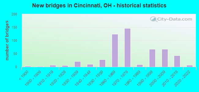
- New bridges - historical statistics
- 3Before 1900
- 21900-1909
- 71910-1919
- 61920-1929
- 211930-1939
- 111940-1949
- 281950-1959
- 1251960-1969
- 1471970-1979
- 91980-1989
- 681990-1999
- 672000-2009
- 432010-2019
- 72020-2022
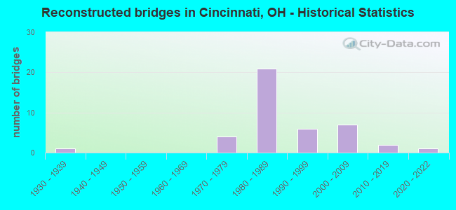
- Reconstructed bridges - Historical Statistics
- 11930-1939
- 01940-1949
- 01950-1959
- 01960-1969
- 41970-1979
- 211980-1989
- 61990-1999
- 72000-2009
- 22010-2019
- 12020-2022
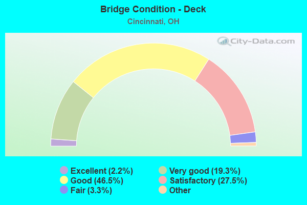
- Bridge Condition - Deck
- 2.2%Excellent
- 19.3%Very good
- 46.5%Good
- 27.5%Satisfactory
- 3.3%Fair
- 1.1%Poor
- 0.4%Serious
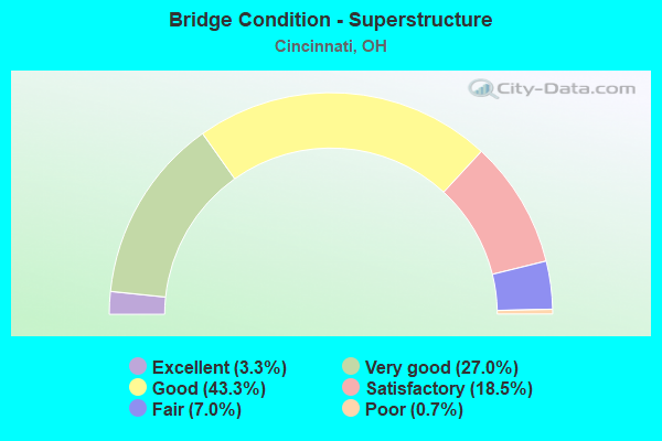
- Bridge Condition - Superstructure
- 3.3%Excellent
- 27.0%Very good
- 43.3%Good
- 18.5%Satisfactory
- 7.0%Fair
- 0.7%Poor
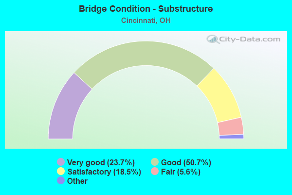
- Bridge Condition - Substructure
- 23.7%Excellent
- 50.7%Very good
- 18.5%Good
- 5.6%Satisfactory
- 1.5%Fair
- 0.7%Poor
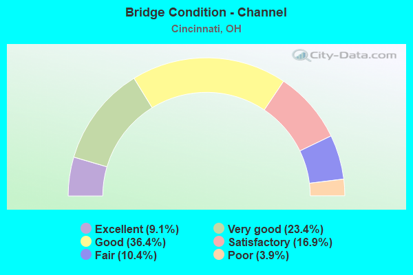
- Bridge Condition - Channel
- 9.1%Excellent
- 23.4%Very good
- 36.4%Good
- 16.9%Satisfactory
- 10.4%Fair
- 3.9%Poor
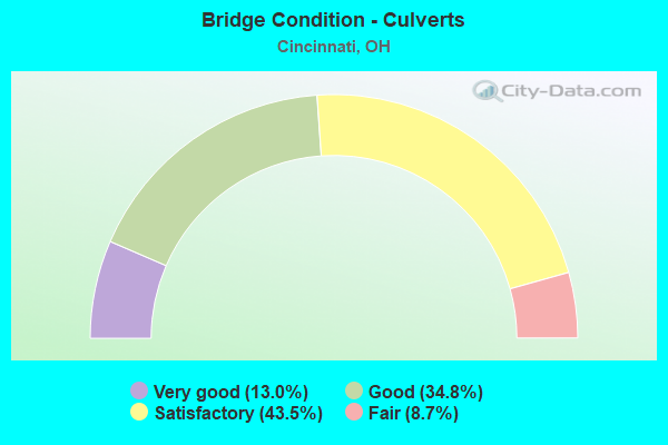
- Bridge Condition - Culverts
- 13.0%Very good
- 34.8%Good
- 43.5%Satisfactory
- 8.7%Fair
Find on map >> Show street view
Structure Number: 310311, Location: 0.25MI S. LYTLE TUNNEL (Lat: 39.099250, Lng: -84.506531), Route carried "on" structure: US 50, Year Built: 1999, Year Reconstructed: 2000, Status: Open, Structure Length: 24.22m (79.46ft), Average Daily Traffic: 12,615 (year 2015), Truck Traffic: 4%, Average Future Daily Traffic: 17,510 (year 2035), Design Load: HS 20, Features Intersected: BROADWAY & 71NB & RAMP K
Minimum Vertical Clearance: 30+ m (98+ ft), Kilometerpoint: 34.472, Lanes on structure: 2, Lanes under structure: 5, Base Highway Network: Yes, Owner: State Highway Agency, Approaching Roadway Width: 11.4m (37.4ft), Material/Design: Steel continuous, Design/Construction: Stringer/Multi-beam, Number Of Spans In Main Unit: 5, Length of Maximum Span: 66.0m (216.5ft), Curb-To-Curb Width: 12.6m (41.3ft), Out-to-Out Width: 13.5m (44.3ft)
Condition: Deck: Good, Superstructure: Very good, Substructure: Good, Operating Rating: 38.9 metric tons, Method Used To Determine Operating Rating: Load Factor (LF) rating reported by rating factor (RF) method using MS18 loading, Inventory Rating: 22.7 metric tons, Method Used To Determine Inventory Rating: Load Factor (LF) rating reported by rating factor (RF) method using MS18 loading, Structural Evaluation: Somewhat better than minimum adequacy, Deck Geometry: Better than present minimum criteria, Underclear: High priority of corrective action, Approach Roadway Alignment: Equal to present desirable criteria, Designated Inspection Frequency: Every 24 months, Inspection Date: September 2021, Deck Structure Type: Concrete Cast-file-Place, Wearing Surface/Protective System: Wearing Surface: Monolithic Concrete, Deck Protection: Epoxy Coated Reinforcing
Find on map >> Show street view
Structure Number: 3103129, Location: .2 MI W OF I75 (Lat: 39.100950, Lng: -84.526631), Route carried "on" structure: US 50, Year Built: 1963, Status: Open, Structure Length: 6.25m (20.51ft), Average Daily Traffic: 24,194 (year 2015), Truck Traffic: 6%, Average Future Daily Traffic: 33,581 (year 2035), Design Load: HS 20, Features Intersected: GEST STREET
Minimum Vertical Clearance: 30+ m (98+ ft), Kilometerpoint: 32.396, Lanes on structure: 4, Lanes under structure: 5, Base Highway Network: Yes, Owner: State Highway Agency, Approaching Roadway Width: 12.8m (42.0ft), Material/Design: Steel continuous, Design/Construction: Stringer/Multi-beam, Number Of Spans In Main Unit: 3, Length of Maximum Span: 27.7m (90.9ft), Curb-To-Curb Width: 15.2m (49.9ft), Out-to-Out Width: 17.4m (57.1ft)
Condition: Deck: Good, Superstructure: Good, Substructure: Satisfactory, Operating Rating: 42.1 metric tons, Method Used To Determine Operating Rating: Load Factor (LF) rating reported by rating factor (RF) method using MS18 loading, Inventory Rating: 32.4 metric tons, Method Used To Determine Inventory Rating: Load Factor (LF) rating reported by rating factor (RF) method using MS18 loading, Structural Evaluation: Equal to present minimum criteria, Deck Geometry: High priority of replacement, Underclear: Better than present minimum criteria, Approach Roadway Alignment: Equal to present desirable criteria, Designated Inspection Frequency: Every 12 months, Inspection Date: August 2021, Deck Structure Type: Concrete Cast-file-Place, Wearing Surface/Protective System: Wearing Surface: Integral Concrete
Find on map >> Show street view
Structure Number: 3103137, Location: OVER NB.71/3RD.ST. RAMP (Lat: 39.099661, Lng: -84.504881), Route carried "on" structure: Ramp US 50, Year Built: 1999, Status: Open, Structure Length: 6.43m (21.10ft), Average Daily Traffic: 56,940 (year 2009), Average Future Daily Traffic: 67,027 (year 2029), Design Load: HS 20+Mod, Features Intersected: I71 NB.
Minimum Vertical Clearance: 4.90m (16.08ft), Kilometerpoint: 34.697, Lanes on structure: 2, Lanes under structure: 3, Owner: State Highway Agency, Approaching Roadway Width: 12.6m (41.3ft), Material/Design: Steel, Design/Construction: Stringer/Multi-beam, Number Of Spans In Main Unit: 1, Length of Maximum Span: 62.4m (204.7ft), Curb-To-Curb Width: 12.6m (41.3ft), Out-to-Out Width: 13.5m (44.3ft)
Condition: Deck: Good, Superstructure: Very good, Substructure: Very good, Operating Rating: 42.1 metric tons, Method Used To Determine Operating Rating: Load Factor (LF) rating reported by rating factor (RF) method using MS18 loading, Inventory Rating: 32.4 metric tons, Method Used To Determine Inventory Rating: Load Factor (LF) rating reported by rating factor (RF) method using MS18 loading, Structural Evaluation: Equal to present desirable criteria, Deck Geometry: Somewhat better than minimum adequacy, Underclear: High priority of corrective action, Approach Roadway Alignment: Equal to present desirable criteria, Designated Inspection Frequency: Every 24 months, Inspection Date: September 2021, Deck Structure Type: Concrete Cast-file-Place, Wearing Surface/Protective System: Wearing Surface: Monolithic Concrete, Deck Protection: Epoxy Coated Reinforcing
Find on map >> Show street view
Structure Number: 3103153, Location: OVER I75 (Lat: 39.101611, Lng: -84.523950), Route carried "on" structure: US 50, Year Built: 1963, Status: Open, Structure Length: 15.97m (52.40ft), Average Daily Traffic: 22,680 (year 2015), Truck Traffic: 6%, Average Future Daily Traffic: 31,480 (year 2035), Design Load: HS 20, Features Intersected: I75;RAMP=I75*S-US50*E
Minimum Vertical Clearance: 30+ m (98+ ft), Kilometerpoint: 32.637, Lanes on structure: 4, Lanes under structure: 12, Base Highway Network: Yes, Owner: State Highway Agency, Approaching Roadway Width: 12.8m (42.0ft), Material/Design: Steel continuous, Design/Construction: Stringer/Multi-beam, Number Of Spans In Main Unit: 6, Length of Maximum Span: 33.8m (110.9ft), Curb or Sidewalk Widths: Left: 0.7m (2.3ft), Right: 2.7m (8.9ft), Curb-To-Curb Width: 15.2m (49.9ft), Out-to-Out Width: 24.7m (81.0ft)
Condition: Deck: Satisfactory, Superstructure: Good, Substructure: Fair, Operating Rating: 42.1 metric tons, Method Used To Determine Operating Rating: Load Factor (LF) rating reported by rating factor (RF) method using MS18 loading, Inventory Rating: 32.4 metric tons, Method Used To Determine Inventory Rating: Load Factor (LF) rating reported by rating factor (RF) method using MS18 loading, Structural Evaluation: Somewhat better than minimum adequacy, Deck Geometry: High priority of replacement, Underclear: Meets minimum limits, Approach Roadway Alignment: Equal to present desirable criteria, Designated Inspection Frequency: Every 12 months, Inspection Date: September 2021, Deck Structure Type: Concrete Cast-file-Place, Wearing Surface/Protective System: Wearing Surface: Integral Concrete
Find on map >> Show street view
Structure Number: 3103161, Location: OVER I-75 SB (Lat: 39.101469, Lng: -84.523811), Route carried "on" structure: Ramp US 50, Year Built: 2000, Status: Open, Structure Length: 15.08m (49.48ft), Average Daily Traffic: 21,300 (year 2000), Average Future Daily Traffic: 29,564 (year 2020), Features Intersected: IR 75 SB AND RAMP
Minimum Vertical Clearance: 30+ m (98+ ft), Kilometerpoint: 32.637, Lanes on structure: 1, Lanes under structure: 3, Owner: State Highway Agency, Approaching Roadway Width: 9.0m (29.5ft), Skew: 3 degrees, Material/Design: Steel continuous, Design/Construction: Stringer/Multi-beam, Number Of Spans In Main Unit: 4, Length of Maximum Span: 54.0m (177.2ft), Curb-To-Curb Width: 9.0m (29.5ft), Out-to-Out Width: 9.9m (32.5ft)
Condition: Deck: Very good, Superstructure: Very good, Substructure: Very good, Operating Rating: 35.6 metric tons, Method Used To Determine Operating Rating: Load and Resistance Factor Rating (LRFR) rating reported by rating factor(RF) method using HL-93 loadings, Inventory Rating: 25.9 metric tons, Method Used To Determine Inventory Rating: Load and Resistance Factor Rating (LRFR) rating reported by rating factor(RF) method using HL-93 loadings, Structural Evaluation: Equal to present minimum criteria, Deck Geometry: Superior to present desirable criteria, Underclear: Meets minimum limits, Approach Roadway Alignment: Equal to present desirable criteria, Designated Inspection Frequency: Every 24 months, Inspection Date: September 2021, Deck Structure Type: Concrete Cast-file-Place, Wearing Surface/Protective System: Wearing Surface: Monolithic Concrete, Deck Protection: Epoxy Coated Reinforcing
Find on map >> Show street view
Structure Number: 3103188, Location: OVER I75 (Lat: 39.101411, Lng: -84.523761), Route carried "on" structure: US 50, Year Built: 1963, Status: Open, Structure Length: 5.55m (18.21ft), Average Daily Traffic: 22,680 (year 2015), Truck Traffic: 6%, Average Future Daily Traffic: 31,480 (year 2035), Design Load: HS 20, Features Intersected: I75*S
Minimum Vertical Clearance: 30+ m (98+ ft), Kilometerpoint: 32.637, Lanes on structure: 2, Lanes under structure: 2, Base Highway Network: Yes, Owner: State Highway Agency, Approaching Roadway Width: 9.8m (32.2ft), Material/Design: Steel continuous, Design/Construction: Stringer/Multi-beam, Number Of Spans In Main Unit: 2, Length of Maximum Span: 29.6m (97.1ft), Curb-To-Curb Width: 11.2m (36.7ft), Out-to-Out Width: 13.1m (43.0ft)
Condition: Deck: Good, Superstructure: Good, Substructure: Satisfactory, Operating Rating: 42.1 metric tons, Method Used To Determine Operating Rating: Allowable Stress (AS) rating reported by rating factor (RF) method using MS18 loading, Inventory Rating: 32.4 metric tons, Method Used To Determine Inventory Rating: Allowable Stress (AS) rating reported by rating factor (RF) method using MS18 loading, Structural Evaluation: Equal to present minimum criteria, Deck Geometry: Somewhat better than minimum adequacy, Underclear: High priority of corrective action, Approach Roadway Alignment: Equal to present desirable criteria, Designated Inspection Frequency: Every 12 months, Inspection Date: September 2021, Deck Structure Type: Concrete Cast-file-Place, Wearing Surface/Protective System: Wearing Surface: Integral Concrete
Find on map >> Show street view
Structure Number: 3103226, Location: OVER 3 RD ST (Lat: 39.098319, Lng: -84.519419), Route carried "on" structure: Ramp US 50, Year Built: 1999, Status: Open, Structure Length: 23.11m (75.82ft), Average Daily Traffic: 29,250 (year 2009), Average Future Daily Traffic: 49,274 (year 2029), Design Load: HS 25 or greater, Features Intersected: US 42
Minimum Vertical Clearance: 30+ m (98+ ft), Kilometerpoint: 33.217, Lanes on structure: 2, Lanes under structure: 4, Owner: State Highway Agency, Approaching Roadway Width: 10.0m (32.8ft), Material/Design: Steel continuous, Design/Construction: Stringer/Multi-beam, Number Of Spans In Main Unit: 6, Length of Maximum Span: 43.5m (142.7ft), Curb-To-Curb Width: 10.0m (32.8ft), Out-to-Out Width: 10.5m (34.4ft)
Condition: Deck: Good, Superstructure: Very good, Substructure: Good, Operating Rating: 77.8 metric tons, Method Used To Determine Operating Rating: Load Factor (LF) rating reported by rating factor (RF) method using MS18 loading, Inventory Rating: 45.4 metric tons, Method Used To Determine Inventory Rating: Load Factor (LF) rating reported by rating factor (RF) method using MS18 loading, Structural Evaluation: Better than present minimum criteria, Deck Geometry: Equal to present minimum criteria, Underclear: High priority of corrective action, Approach Roadway Alignment: Equal to present desirable criteria, Designated Inspection Frequency: Every 24 months, Inspection Date: September 2021, Deck Structure Type: Concrete Cast-file-Place, Wearing Surface/Protective System: Wearing Surface: Monolithic Concrete, Deck Protection: Epoxy Coated Reinforcing
Find on map >> Show street view
Structure Number: 3103234, Location: RP UNDR NB71/OVR 3RD (Lat: 39.097869, Lng: -84.521261), Route carried "on" structure: Ramp Interstate 75, Year Built: 2000, Status: Open, Structure Length: 19.62m (64.37ft), Average Daily Traffic: 58,035 (year 2009), Truck Traffic: 13%, Average Future Daily Traffic: 80,553 (year 2029), Design Load: HS 20+Mod, Features Intersected: USR 42, Facility Carried by Structure: US 50 RAMP B
Minimum Vertical Clearance: 5.18m (16.99ft), Kilometerpoint: 0.370, Lanes on structure: 2, Lanes under structure: 4, Owner: State Highway Agency, Approaching Roadway Width: 12.6m (41.3ft), Material/Design: Steel continuous, Design/Construction: Stringer/Multi-beam, Number Of Spans In Main Unit: 4, Length of Maximum Span: 58.4m (191.6ft), Curb-To-Curb Width: 12.6m (41.3ft), Out-to-Out Width: 13.5m (44.3ft)
Condition: Deck: Very good, Superstructure: Very good, Substructure: Very good, Operating Rating: 42.1 metric tons, Method Used To Determine Operating Rating: Load Factor (LF) rating reported by rating factor (RF) method using MS18 loading, Inventory Rating: 32.4 metric tons, Method Used To Determine Inventory Rating: Load Factor (LF) rating reported by rating factor (RF) method using MS18 loading, Structural Evaluation: Equal to present desirable criteria, Deck Geometry: Equal to present desirable criteria, Underclear: High priority of corrective action, Approach Roadway Alignment: Equal to present desirable criteria, Designated Inspection Frequency: Every 24 months, Inspection Date: December 2021, Deck Structure Type: Concrete Cast-file-Place, Wearing Surface/Protective System: Wearing Surface: Monolithic Concrete, Deck Protection: Epoxy Coated Reinforcing
Find on map >> Show street view
Structure Number: 3103269, Location: 3RD ST. ON RAMP TO S.71 (Lat: 39.098031, Lng: -84.518811), Route carried "on" structure: Ramp Interstate 71, Year Built: 2000, Status: Open, Structure Length: 25.10m (82.35ft), Average Daily Traffic: 27,975 (year 2009), Truck Traffic: 13%, Average Future Daily Traffic: 38,829 (year 2029), Design Load: HS 20+Mod, Features Intersected: USR 42
Minimum Vertical Clearance: 30+ m (98+ ft), Kilometerpoint: 0.644, Lanes on structure: 2, Lanes under structure: 10, Owner: State Highway Agency, Approaching Roadway Width: 10.5m (34.4ft), Material/Design: Steel, Design/Construction: Girder and Floorbeam System, Number Of Spans In Main Unit: 4, Length of Maximum Span: 63.0m (206.7ft), Curb-To-Curb Width: 10.5m (34.4ft), Out-to-Out Width: 11.5m (37.7ft)
Condition: Deck: Good, Superstructure: Very good, Substructure: Good, Operating Rating: 61.6 metric tons, Method Used To Determine Operating Rating: Load Factor (LF) rating reported by rating factor (RF) method using MS18 loading, Inventory Rating: 35.6 metric tons, Method Used To Determine Inventory Rating: Load Factor (LF) rating reported by rating factor (RF) method using MS18 loading, Structural Evaluation: Better than present minimum criteria, Deck Geometry: Better than present minimum criteria, Underclear: High priority of corrective action, Approach Roadway Alignment: Equal to present desirable criteria, Designated Inspection Frequency: Every 24 months, Inspection Date: September 2021, Deck Structure Type: Concrete Cast-file-Place, Wearing Surface/Protective System: Wearing Surface: Monolithic Concrete, Deck Protection: Epoxy Coated Reinforcing
Find on map >> Show street view
Structure Number: 3103285, Location: 21.78 MI E OF STATE LINE (Lat: 39.100131, Lng: -84.502850), Route carried "on" structure: US 50, Year Built: 2000, Status: Open, Structure Length: 1.35m (4.43ft), Average Daily Traffic: 43,145 (year 2015), Truck Traffic: 4%, Average Future Daily Traffic: 59,885 (year 2035), Design Load: HS 20+Mod, Features Intersected: LYTLE PLACE DRIVE
Minimum Vertical Clearance: 30+ m (98+ ft), Kilometerpoint: 34.826, Lanes on structure: 6, Lanes under structure: 2, Base Highway Network: Yes, Owner: State Highway Agency, Approaching Roadway Width: 10.4m (34.1ft), Material/Design: Concrete, Design/Construction: Culvert, Number Of Spans In Main Unit: 1, Length of Maximum Span: 12.8m (42.0ft), Curb or Sidewalk Widths: Left: 2.4m (7.9ft), Right: 1.5m (4.9ft)
Condition: Culverts: Very good, Operating Rating: 48.6 metric tons, Method Used To Determine Operating Rating: Load Factor (LF) rating reported by rating factor (RF) method using MS18 loading, Inventory Rating: 45.4 metric tons, Method Used To Determine Inventory Rating: Load Factor (LF) rating reported by rating factor (RF) method using MS18 loading, Structural Evaluation: Equal to present desirable criteria, Underclear: High priority of corrective action, Approach Roadway Alignment: Equal to present desirable criteria, Designated Inspection Frequency: Every 24 months, Inspection Date: September 2021, Deck Structure Type: Concrete Cast-file-Place
Find on map >> Show street view
Structure Number: 3103293, Location: .01 MI E. OF IR75 (Lat: 39.097719, Lng: -84.520450), Route carried "on" structure: US 50, Year Built: 2000, Status: Open, Structure Length: 27.95m (91.70ft), Average Daily Traffic: 13,902 (year 2015), Truck Traffic: 6%, Average Future Daily Traffic: 19,296 (year 2035), Design Load: HS 20+Mod, Features Intersected: US 42
Minimum Vertical Clearance: 30+ m (98+ ft), Kilometerpoint: 33.233, Lanes on structure: 2, Lanes under structure: 9, Base Highway Network: Yes, Owner: State Highway Agency, Approaching Roadway Width: 12.6m (41.3ft), Material/Design: Steel continuous, Design/Construction: Stringer/Multi-beam, Number Of Spans In Main Unit: 6, Length of Maximum Span: 55.5m (182.1ft), Curb-To-Curb Width: 12.6m (41.3ft), Out-to-Out Width: 13.6m (44.6ft)
Condition: Deck: Good, Superstructure: Very good, Substructure: Very good, Operating Rating: 42.1 metric tons, Method Used To Determine Operating Rating: Load Factor (LF) rating reported by rating factor (RF) method using MS18 loading, Inventory Rating: 32.4 metric tons, Method Used To Determine Inventory Rating: Load Factor (LF) rating reported by rating factor (RF) method using MS18 loading, Structural Evaluation: Equal to present desirable criteria, Deck Geometry: Better than present minimum criteria, Underclear: High priority of corrective action, Approach Roadway Alignment: Equal to present desirable criteria, Designated Inspection Frequency: Every 24 months, Inspection Date: September 2021, Deck Structure Type: Concrete Cast-file-Place, Wearing Surface/Protective System: Wearing Surface: Monolithic Concrete, Deck Protection: Epoxy Coated Reinforcing
Find on map >> Show street view
Structure Number: 3103307, Location: 2ND ST RAMP TO US 50 (Lat: 39.098650, Lng: -84.506439), Route carried "on" structure: Ramp US 50, Year Built: 2000, Status: Open, Structure Length: 29.32m (96.19ft), Average Daily Traffic: 28,470 (year 2009), Truck Traffic: 7%, Average Future Daily Traffic: 39,516 (year 2029), Design Load: HS 20+Mod, Features Intersected: BROADWAY
Minimum Vertical Clearance: 30+ m (98+ ft), Kilometerpoint: 34.408, Lanes on structure: 1, Lanes under structure: 5, Owner: State Highway Agency, Approaching Roadway Width: 9.0m (29.5ft), Material/Design: Prestressed concrete continuous, Design/Construction: Stringer/Multi-beam, Number Of Spans In Main Unit: 5, Length of Maximum Span: 41.6m (136.5ft), Curb-To-Curb Width: 9.0m (29.5ft), Out-to-Out Width: 9.9m (32.5ft)
Condition: Deck: Good, Superstructure: Satisfactory, Substructure: Good, Operating Rating: 42.1 metric tons, Method Used To Determine Operating Rating: Load Factor (LF) rating reported by rating factor (RF) method using MS18 loading, Inventory Rating: 32.4 metric tons, Method Used To Determine Inventory Rating: Load Factor (LF) rating reported by rating factor (RF) method using MS18 loading, Structural Evaluation: Equal to present minimum criteria, Deck Geometry: Superior to present desirable criteria, Underclear: High priority of corrective action, Approach Roadway Alignment: Equal to present desirable criteria, Designated Inspection Frequency: Every 12 months, Inspection Date: October 2021, Deck Structure Type: Concrete Cast-file-Place, Wearing Surface/Protective System: Wearing Surface: Integral Concrete, Deck Protection: Epoxy Coated Reinforcing
Find on map >> Show street view
Structure Number: 3103323, Location: 500' EAST OF COLISEUM (Lat: 39.099789, Lng: -84.502711), Route carried "on" structure: City street LYTPK, Year Built: 1976, Status: Open, Structure Length: 2.06m (6.76ft), Average Daily Traffic: 500 (year 1900), Truck Traffic: 20%, Average Future Daily Traffic: 12,552 (year 1920), Design Load: HS 20, Features Intersected: US52 US50 (USR)RAMPS, Facility Carried by Structure: LYTLE ST
Minimum Vertical Clearance: 30+ m (98+ ft), Kilometerpoint: 0.000, Lanes on structure: 2, Lanes under structure: 2, Owner: Private, Approaching Roadway Width: 7.9m (25.9ft), Material/Design: Steel, Design/Construction: Stringer/Multi-beam, Number Of Spans In Main Unit: 1, Length of Maximum Span: 20.1m (65.9ft), Curb or Sidewalk Widths: Left: 3.7m (12.1ft), Right: 0.0m, Curb-To-Curb Width: 7.8m (25.6ft), Out-to-Out Width: 12.6m (41.3ft)
Condition: Deck: Very good, Superstructure: Very good, Substructure: Very good, Operating Rating: 42.1 metric tons, Method Used To Determine Operating Rating: Load Factor (LF) rating reported by rating factor (RF) method using MS18 loading, Inventory Rating: 32.4 metric tons, Method Used To Determine Inventory Rating: Load Factor (LF) rating reported by rating factor (RF) method using MS18 loading, Structural Evaluation: Equal to present desirable criteria, Deck Geometry: Meets minimum limits, Underclear: High priority of corrective action, Approach Roadway Alignment: Better than present minimum criteria, Designated Inspection Frequency: Every 24 months, Inspection Date: September 2021, Deck Structure Type: Concrete Cast-file-Place, Wearing Surface/Protective System: Wearing Surface: Integral Concrete
Find on map >> Show street view
Structure Number: 3103374, Location: AT INT OF I471 & US50 (Lat: 39.103531, Lng: -84.499350), Route carried "on" structure: Ramp US 50, Year Built: 1974, Year Reconstructed: 1985, Status: Open, Structure Length: 16.47m (54.04ft), Average Daily Traffic: 19,430 (year 2011), Truck Traffic: 7%, Average Future Daily Traffic: 26,969 (year 2031), Design Load: HS 20+Mod, Features Intersected: MONASTERY ST;US50*W RAMP
Minimum Vertical Clearance: 5.11m (16.77ft), Kilometerpoint: 35.373, Lanes on structure: 1, Lanes under structure: 5, Owner: State Highway Agency, Approaching Roadway Width: 8.2m (26.9ft), Material/Design: Steel continuous, Design/Construction: Stringer/Multi-beam, Number Of Spans In Main Unit: 10, Length of Maximum Span: 20.4m (66.9ft), Curb-To-Curb Width: 8.6m (28.2ft), Out-to-Out Width: 9.2m (30.2ft)
Condition: Deck: Good, Superstructure: Satisfactory, Substructure: Satisfactory, Operating Rating: 48.6 metric tons, Method Used To Determine Operating Rating: Load and Resistance Factor Rating (LRFR) rating reported by rating factor(RF) method using HL-93 loadings, Inventory Rating: 37.6 metric tons, Method Used To Determine Inventory Rating: Load and Resistance Factor Rating (LRFR) rating reported by rating factor(RF) method using HL-93 loadings, Structural Evaluation: Equal to present minimum criteria, Deck Geometry: Superior to present desirable criteria, Underclear: Meets minimum limits, Approach Roadway Alignment: Equal to present desirable criteria, Designated Inspection Frequency: Every 12 months, Inspection Date: September 2021, Deck Structure Type: Concrete Cast-file-Place, Wearing Surface/Protective System: Wearing Surface: Latex Concrete, Deck Protection: Epoxy Coated Reinforcing
Find on map >> Show street view
Structure Number: 310339, Location: N OF I471 & US50 INT (Lat: 39.103181, Lng: -84.502469), Route carried "on" structure: Ramp US 50, Year Built: 1938, Year Reconstructed: 1997, Status: Open, Structure Length: 50.57m (165.91ft), Average Daily Traffic: 56,580 (year 2005), Truck Traffic: 3%, Average Future Daily Traffic: 78,533 (year 2025), Design Load: HS 20+Mod, Features Intersected: IR471,RAMP,EGG,CUL, Facility Carried by Structure: COLUMBIA PARKWAY
Minimum Vertical Clearance: 30+ m (98+ ft), Kilometerpoint: 35.084, Lanes on structure: 4, Lanes under structure: 19, Owner: State Highway Agency, Approaching Roadway Width: 17.1m (56.1ft), Material/Design: Steel, Design/Construction: Truss - Deck, Number Of Spans In Main Unit: 7, Number Of Approach Spans: 10, Length of Maximum Span: 51.8m (169.9ft), Curb or Sidewalk Widths: Left: 0.0m, Right: 3.3m (10.8ft), Curb-To-Curb Width: 17.1m (56.1ft), Out-to-Out Width: 21.9m (71.9ft)
Condition: Deck: Satisfactory, Superstructure: Satisfactory, Substructure: Good, Operating Rating: 38.9 metric tons, Method Used To Determine Operating Rating: Load Factor (LF) rating reported by rating factor (RF) method using MS18 loading, Inventory Rating: 22.7 metric tons, Method Used To Determine Inventory Rating: Load Factor (LF) rating reported by rating factor (RF) method using MS18 loading, Structural Evaluation: Somewhat better than minimum adequacy, Deck Geometry: Somewhat better than minimum adequacy, Underclear: High priority of corrective action, Approach Roadway Alignment: Equal to present desirable criteria, Designated Inspection Frequency: Every 12 months, Critical Feature Inspection Frequency: Every 24 months, Inspection Date: September 2021, Critical Feature Inspection Date: September 2020, Deck Structure Type: Concrete Cast-file-Place, Wearing Surface/Protective System: Wearing Surface: Monolithic Concrete, Deck Protection: Epoxy Coated Reinforcing
Find on map >> Show street view
Structure Number: 3103404, Location: AT I471 & US50 INT (Lat: 39.103150, Lng: -84.503269), Route carried "on" structure: Ramp US 50, Year Built: 1978, Status: Open, Structure Length: 5.91m (19.39ft), Average Daily Traffic: 10,000 (year 2000), Truck Traffic: 1%, Average Future Daily Traffic: 13,880 (year 2020), Design Load: HS 20+Mod, Features Intersected: BUTLER ST, PARKING AREA, Facility Carried by Structure: COLUMBIA PARKWAY
Minimum Vertical Clearance: 30+ m (98+ ft), Kilometerpoint: 35.100, Lanes on structure: 1, Lanes under structure: 2, Owner: State Highway Agency, Approaching Roadway Width: 6.1m (20.0ft), Skew: 9 degrees, Material/Design: Steel continuous, Design/Construction: Stringer/Multi-beam, Number Of Spans In Main Unit: 2, Length of Maximum Span: 25.9m (85.0ft), Curb-To-Curb Width: 5.8m (19.0ft), Out-to-Out Width: 7.7m (25.3ft)
Condition: Deck: Satisfactory, Superstructure: Very good, Substructure: Good, Operating Rating: 68.0 metric tons, Method Used To Determine Operating Rating: Load Factor (LF) rating reported by rating factor (RF) method using MS18 loading, Inventory Rating: 38.9 metric tons, Method Used To Determine Inventory Rating: Load Factor (LF) rating reported by rating factor (RF) method using MS18 loading, Structural Evaluation: Better than present minimum criteria, Deck Geometry: Meets minimum limits, Underclear: High priority of corrective action, Approach Roadway Alignment: Equal to present desirable criteria, Designated Inspection Frequency: Every 12 months, Critical Feature Inspection Frequency: Every 24 months, Inspection Date: September 2021, Critical Feature Inspection Date: September 2020, Deck Structure Type: Concrete Cast-file-Place, Wearing Surface/Protective System: Wearing Surface: Monolithic Concrete
Find on map >> Show street view
Structure Number: 3103412, Location: AT INT OF IR471 AND US50 (Lat: 39.101081, Lng: -84.502139), Route carried "on" structure: US 50, Year Built: 2000, Status: Open, Structure Length: 45.86m (150.46ft), Average Daily Traffic: 21,573 (year 2015), Truck Traffic: 4%, Average Future Daily Traffic: 29,943 (year 2035), Design Load: HS 20+Mod, Features Intersected: BUTLR,CULV,EGGST,471,MON
Minimum Vertical Clearance: 30+ m (98+ ft), Kilometerpoint: 34.971, Lanes on structure: 3, Lanes under structure: 12, Base Highway Network: Yes, Owner: State Highway Agency, Approaching Roadway Width: 10.4m (34.1ft), Skew: 1 degrees, Material/Design: Steel continuous, Design/Construction: Box Beam or Girders - Multiple, Number Of Spans In Main Unit: 7, Number Of Approach Spans: 3, Length of Maximum Span: 65.5m (214.9ft), Curb-To-Curb Width: 10.5m (34.4ft), Out-to-Out Width: 11.5m (37.7ft)
Condition: Deck: Good, Superstructure: Very good, Substructure: Very good, Operating Rating: 42.1 metric tons, Method Used To Determine Operating Rating: Load Factor (LF) rating reported by rating factor (RF) method using MS18 loading, Inventory Rating: 32.4 metric tons, Method Used To Determine Inventory Rating: Load Factor (LF) rating reported by rating factor (RF) method using MS18 loading, Structural Evaluation: Equal to present desirable criteria, Deck Geometry: High priority of replacement, Underclear: High priority of corrective action, Approach Roadway Alignment: Somewhat better than minimum adequacy, Designated Inspection Frequency: Every 24 months, Inspection Date: September 2021, Deck Structure Type: Concrete Cast-file-Place, Wearing Surface/Protective System: Wearing Surface: Monolithic Concrete, Deck Protection: Epoxy Coated Reinforcing
Find on map >> Show street view
Structure Number: 310342, Location: AT INT.IR471 AND US50 (Lat: 39.101169, Lng: -84.502289), Route carried "on" structure: US 50, Year Built: 2000, Status: Open, Structure Length: 38.96m (127.82ft), Average Daily Traffic: 21,573 (year 2015), Truck Traffic: 4%, Average Future Daily Traffic: 29,943 (year 2035), Features Intersected: BUTLR,CULVR,EGGST,471,MO
Minimum Vertical Clearance: 30+ m (98+ ft), Kilometerpoint: 34.971, Lanes on structure: 3, Lanes under structure: 12, Base Highway Network: Yes, Owner: State Highway Agency, Approaching Roadway Width: 18.0m (59.1ft), Skew: 1 degrees, Material/Design: Steel continuous, Design/Construction: Box Beam or Girders - Multiple, Number Of Spans In Main Unit: 5, Number Of Approach Spans: 5, Length of Maximum Span: 66.8m (219.2ft), Curb-To-Curb Width: 15.1m (49.5ft), Out-to-Out Width: 16.1m (52.8ft)
Condition: Deck: Good, Superstructure: Very good, Substructure: Very good, Operating Rating: 42.1 metric tons, Method Used To Determine Operating Rating: Load Factor (LF) rating reported by rating factor (RF) method using MS18 loading, Inventory Rating: 32.4 metric tons, Method Used To Determine Inventory Rating: Load Factor (LF) rating reported by rating factor (RF) method using MS18 loading, Structural Evaluation: Equal to present desirable criteria, Deck Geometry: Equal to present minimum criteria, Underclear: Meets minimum limits, Approach Roadway Alignment: Equal to present desirable criteria, Designated Inspection Frequency: Every 24 months, Inspection Date: September 2021, Deck Structure Type: Concrete Cast-file-Place, Wearing Surface/Protective System: Wearing Surface: Monolithic Concrete, Deck Protection: Epoxy Coated Reinforcing
Find on map >> Show street view
Structure Number: 3103579, Location: .3 MI E OF I471 (Lat: 39.105100, Lng: -84.496289), Route carried "on" structure: Ramp US 50, Year Built: 1972, Year Reconstructed: 2004, Status: Open, Structure Length: 11.59m (38.02ft), Average Daily Traffic: 24,410 (year 2009), Truck Traffic: 6%, Average Future Daily Traffic: 33,881 (year 2029), Design Load: HS 20+Mod, Features Intersected: RELIEF
Minimum Vertical Clearance: 30+ m (98+ ft), Kilometerpoint: 35.695, Lanes on structure: 1, Owner: State Highway Agency, Approaching Roadway Width: 4.3m (14.1ft), Material/Design: Concrete continuous, Design/Construction: Tee Beam, Number Of Spans In Main Unit: 12, Length of Maximum Span: 11.7m (38.4ft), Curb-To-Curb Width: 3.6m (11.8ft), Out-to-Out Width: 4.3m (14.1ft)
Condition: Deck: Good, Superstructure: Fair, Substructure: Satisfactory, Operating Rating: 42.1 metric tons, Method Used To Determine Operating Rating: Load Factor (LF) rating reported by rating factor (RF) method using MS18 loading, Inventory Rating: 32.4 metric tons, Method Used To Determine Inventory Rating: Load Factor (LF) rating reported by rating factor (RF) method using MS18 loading, Structural Evaluation: Somewhat better than minimum adequacy, Deck Geometry: High priority of replacement, Waterway Adequacy: Superior to present desirable criteria, Approach Roadway Alignment: Equal to present desirable criteria, Designated Inspection Frequency: Every 12 months, Inspection Date: August 2021, Deck Structure Type: Concrete Cast-file-Place, Wearing Surface/Protective System: Wearing Surface: Integral Concrete
Find on map >> Show street view
Structure Number: 3103587, Location: E OF MARTINE DRIVE (Lat: 39.106131, Lng: -84.495081), Route carried "on" structure: US 50, Year Built: 2004, Status: Open, Structure Length: 12.46m (40.88ft), Average Daily Traffic: 20,490 (year 2015), Truck Traffic: 4%, Average Future Daily Traffic: 28,440 (year 2035), Design Load: HS 25 or greater, Features Intersected: RELIEF
Minimum Vertical Clearance: 30+ m (98+ ft), Kilometerpoint: 35.760, Lanes on structure: 4, Base Highway Network: Yes (, Subroute: 1), Owner: State Highway Agency, Approaching Roadway Width: 34.8m (114.2ft), Skew: 20 degrees, Material/Design: Prestressed concrete continuous, Design/Construction: Stringer/Multi-beam, Number Of Spans In Main Unit: 5, Length of Maximum Span: 26.7m (87.6ft), Curb-To-Curb Width: 20.8m (68.2ft), Out-to-Out Width: 21.3m (69.9ft)
Condition: Deck: Good, Superstructure: Very good, Substructure: Very good, Operating Rating: 55.1 metric tons, Method Used To Determine Operating Rating: Load and Resistance Factor Rating (LRFR) rating reported by rating factor(RF) method using HL-93 loadings, Inventory Rating: 42.1 metric tons, Method Used To Determine Inventory Rating: Load and Resistance Factor Rating (LRFR) rating reported by rating factor(RF) method using HL-93 loadings, Structural Evaluation: Equal to present desirable criteria, Deck Geometry: Superior to present desirable criteria, Waterway Adequacy: Superior to present desirable criteria, Approach Roadway Alignment: Superior to present desirable criteria, Designated Inspection Frequency: Every 24 months, Inspection Date: August 2021, Deck Structure Type: Concrete Cast-file-Place, Wearing Surface/Protective System: Wearing Surface: Monolithic Concrete, Deck Protection: Epoxy Coated Reinforcing
Find on map >> Show street view
Structure Number: 3103595, Location: W. OF MARTIN DR OVER US50 (Lat: 39.106519, Lng: -84.494189), Route carried "on" structure: Ramp US 50, Year Built: 1958, Year Reconstructed: 1987, Status: Posted for load, Structure Length: 15.54m (50.98ft), Average Daily Traffic: 24,410 (year 2009), Truck Traffic: 6%, Average Future Daily Traffic: 33,881 (year 2029), Design Load: HS 20+Mod, Features Intersected: MARTN DRIVE RAMP, Facility Carried by Structure: MARTIN DRIVE
Minimum Vertical Clearance: 30+ m (98+ ft), Kilometerpoint: 35.888, Lanes on structure: 1, Owner: State Highway Agency, Approaching Roadway Width: 6.2m (20.3ft), Material/Design: Steel, Design/Construction: Stringer/Multi-beam, Number Of Spans In Main Unit: 9, Length of Maximum Span: 20.1m (65.9ft), Curb-To-Curb Width: 6.2m (20.3ft), Out-to-Out Width: 7.2m (23.6ft)
Condition: Deck: Satisfactory, Superstructure: Good, Substructure: Good, Operating Rating: 35.6 metric tons, Method Used To Determine Operating Rating: Load Factor (LF) rating reported by rating factor (RF) method using MS18 loading, Inventory Rating: 22.7 metric tons, Method Used To Determine Inventory Rating: Load Factor (LF) rating reported by rating factor (RF) method using MS18 loading, Structural Evaluation: Somewhat better than minimum adequacy, Deck Geometry: Somewhat better than minimum adequacy, Waterway Adequacy: Superior to present desirable criteria, Approach Roadway Alignment: Equal to present minimum criteria, Bridge Posting: Required (Relationship of Operating Rating to Maximum Legal Load: 10.0 - 19.9% below), Designated Inspection Frequency: Every 12 months, Inspection Date: November 2021, Deck Structure Type: Concrete Cast-file-Place, Wearing Surface/Protective System: Wearing Surface: Monolithic Concrete
Find on map >> Show street view
Structure Number: 3103609, Location: .5 MI E OF I471 (Lat: 39.107781, Lng: -84.493461), Route carried "on" structure: Ramp US 50, Year Built: 1958, Year Reconstructed: 1986, Status: Posted for load, Structure Length: 4.10m (13.45ft), Average Daily Traffic: 24,732 (year 2009), Truck Traffic: 6%, Average Future Daily Traffic: 36,511 (year 2029), Design Load: H 20, Features Intersected: US50, Facility Carried by Structure: RAMP TO MARTIN DR
Minimum Vertical Clearance: 30+ m (98+ ft), Kilometerpoint: 36.017, Lanes on structure: 1, Lanes under structure: 6, Owner: State Highway Agency, Approaching Roadway Width: 7.3m (24.0ft), Skew: 4 degrees, Material/Design: Steel, Design/Construction: Girder and Floorbeam System, Number Of Spans In Main Unit: 1, Length of Maximum Span: 40.0m (131.2ft), Curb-To-Curb Width: 7.3m (24.0ft), Out-to-Out Width: 7.8m (25.6ft)
Condition: Deck: Good, Superstructure: Satisfactory, Substructure: Good, Operating Rating: 35.6 metric tons, Method Used To Determine Operating Rating: Load Factor (LF) rating reported by rating factor (RF) method using MS18 loading, Inventory Rating: 22.7 metric tons, Method Used To Determine Inventory Rating: Load Factor (LF) rating reported by rating factor (RF) method using MS18 loading, Structural Evaluation: Somewhat better than minimum adequacy, Deck Geometry: Better than present minimum criteria, Underclear: High priority of corrective action, Approach Roadway Alignment: Better than present minimum criteria, Bridge Posting: Required (Relationship of Operating Rating to Maximum Legal Load: 20.0 - 29.9% below), Designated Inspection Frequency: Every 12 months, Critical Feature Inspection Frequency: Every 24 months, Inspection Date: October 2021, Critical Feature Inspection Date: October 2021, Deck Structure Type: Concrete Cast-file-Place, Wearing Surface/Protective System: Wearing Surface: Monolithic Concrete
Find on map >> Show street view
Structure Number: 3103633, Location: 1.1 MI E OF MARTIN DR (Lat: 39.117511, Lng: -84.485411), Route carried "on" structure: US 50, Year Built: 1938, Year Reconstructed: 1992, Status: Open, Structure Length: 9.05m (29.69ft), Average Daily Traffic: 26,305 (year 2015), Truck Traffic: 4%, Average Future Daily Traffic: 36,511 (year 2035), Design Load: HS 20+Mod, Features Intersected: RELIEF
Minimum Vertical Clearance: 30+ m (98+ ft), Kilometerpoint: 37.272, Lanes on structure: 4, Base Highway Network: Yes (, Subroute: 1), Owner: State Highway Agency, Approaching Roadway Width: 17.1m (56.1ft), Material/Design: Steel continuous, Design/Construction: Stringer/Multi-beam, Number Of Spans In Main Unit: 3, Number Of Approach Spans: 2, Length of Maximum Span: 21.9m (71.9ft), Curb-To-Curb Width: 19.7m (64.6ft), Out-to-Out Width: 20.6m (67.6ft)
Condition: Deck: Satisfactory, Superstructure: Satisfactory, Substructure: Fair, Operating Rating: 42.1 metric tons, Method Used To Determine Operating Rating: Allowable Stress (AS) rating reported by rating factor (RF) method using MS18 loading, Inventory Rating: 32.4 metric tons, Method Used To Determine Inventory Rating: Allowable Stress (AS) rating reported by rating factor (RF) method using MS18 loading, Structural Evaluation: Somewhat better than minimum adequacy, Deck Geometry: Better than present minimum criteria, Waterway Adequacy: Superior to present desirable criteria, Approach Roadway Alignment: Better than present minimum criteria, Designated Inspection Frequency: Every 12 months, Inspection Date: August 2021, Deck Structure Type: Concrete Cast-file-Place, Wearing Surface/Protective System: Wearing Surface: Monolithic Concrete, Deck Protection: Epoxy Coated Reinforcing
Find on map >> Show street view
Structure Number: 3103668, Location: 2.5 MI E OF IR 471 (Lat: 39.124869, Lng: -84.469489), Route carried "on" structure: US 50, Year Built: 1936, Year Reconstructed: 1992, Status: Open, Structure Length: 3.41m (11.19ft), Average Daily Traffic: 26,305 (year 2015), Truck Traffic: 3%, Average Future Daily Traffic: 36,511 (year 2035), Design Load: H 20, Features Intersected: COLLINS AVENUE
Minimum Vertical Clearance: 30+ m (98+ ft), Kilometerpoint: 38.769, Lanes on structure: 5, Lanes under structure: 2, Base Highway Network: Yes (, Subroute: 1), Owner: State Highway Agency, Approaching Roadway Width: 14.0m (45.9ft), Material/Design: Steel continuous, Design/Construction: Stringer/Multi-beam, Number Of Spans In Main Unit: 2, Length of Maximum Span: 17.1m (56.1ft), Curb-To-Curb Width: 16.6m (54.5ft), Out-to-Out Width: 17.5m (57.4ft)
Condition: Deck: Good, Superstructure: Good, Substructure: Good, Operating Rating: 42.1 metric tons, Method Used To Determine Operating Rating: Allowable Stress (AS) rating reported by rating factor (RF) method using MS18 loading, Inventory Rating: 32.4 metric tons, Method Used To Determine Inventory Rating: Allowable Stress (AS) rating reported by rating factor (RF) method using MS18 loading, Structural Evaluation: Better than present minimum criteria, Deck Geometry: High priority of replacement, Underclear: Equal to present minimum criteria, Approach Roadway Alignment: Equal to present desirable criteria, Designated Inspection Frequency: Every 24 months, Inspection Date: August 2021, Deck Structure Type: Concrete Cast-file-Place, Wearing Surface/Protective System: Wearing Surface: Monolithic Concrete, Deck Protection: Epoxy Coated Reinforcing
Find on map >> Show street view
Structure Number: 3103692, Location: OVER SR561 (Lat: 39.120661, Lng: -84.418589), Route carried "on" structure: US 50, Year Built: 1962, Status: Open, Structure Length: 5.40m (17.72ft), Average Daily Traffic: 11,201 (year 2015), Truck Traffic: 1%, Average Future Daily Traffic: 15,547 (year 2035), Design Load: HS 20, Features Intersected: S561*S;S32*W(S125*W,1SR)
Minimum Vertical Clearance: 30+ m (98+ ft), Kilometerpoint: 44.659, Lanes on structure: 4, Lanes under structure: 2, Base Highway Network: Yes (, Subroute: 1), Owner: State Highway Agency, Approaching Roadway Width: 11.0m (36.1ft), Skew: 31 degrees, Material/Design: Steel continuous, Design/Construction: Stringer/Multi-beam, Number Of Spans In Main Unit: 3, Length of Maximum Span: 23.2m (76.1ft), Curb or Sidewalk Widths: Left: 0.3m (1.0ft), Right: 0.3m (1.0ft), Curb-To-Curb Width: 15.2m (49.9ft), Out-to-Out Width: 30.0m (98.4ft)
Condition: Deck: Satisfactory, Superstructure: Good, Substructure: Good, Operating Rating: 42.1 metric tons, Method Used To Determine Operating Rating: Load Factor (LF) rating reported by rating factor (RF) method using MS18 loading, Inventory Rating: 32.4 metric tons, Method Used To Determine Inventory Rating: Load Factor (LF) rating reported by rating factor (RF) method using MS18 loading, Structural Evaluation: Better than present minimum criteria, Deck Geometry: High priority of replacement, Underclear: Meets minimum limits, Approach Roadway Alignment: Equal to present desirable criteria, Designated Inspection Frequency: Every 12 months, Inspection Date: August 2021, Deck Structure Type: Concrete Cast-file-Place, Wearing Surface/Protective System: Wearing Surface: Latex Concrete
Find on map >> Show street view
Structure Number: 3103722, Location: .1 MI E OF SR561 (Lat: 39.122031, Lng: -84.417339), Route carried "on" structure: US 50, Year Built: 1962, Status: Open, Structure Length: 5.40m (17.72ft), Average Daily Traffic: 11,201 (year 2015), Truck Traffic: 1%, Average Future Daily Traffic: 15,547 (year 2035), Design Load: HS 20, Features Intersected: LINWOOD AVENUE
Minimum Vertical Clearance: 30+ m (98+ ft), Kilometerpoint: 44.852, Lanes on structure: 4, Lanes under structure: 2, Base Highway Network: Yes (, Subroute: 1), Owner: State Highway Agency, Approaching Roadway Width: 14.6m (47.9ft), Skew: 30 degrees, Material/Design: Steel continuous, Design/Construction: Stringer/Multi-beam, Number Of Spans In Main Unit: 3, Length of Maximum Span: 19.8m (65.0ft), Curb or Sidewalk Widths: Left: 0.3m (1.0ft), Right: 0.3m (1.0ft), Curb-To-Curb Width: 24.9m (81.7ft), Out-to-Out Width: 26.3m (86.3ft)
Condition: Deck: Satisfactory, Superstructure: Good, Substructure: Good, Operating Rating: 42.1 metric tons, Method Used To Determine Operating Rating: Load Factor (LF) rating reported by rating factor (RF) method using MS18 loading, Inventory Rating: 32.4 metric tons, Method Used To Determine Inventory Rating: Load Factor (LF) rating reported by rating factor (RF) method using MS18 loading, Structural Evaluation: Better than present minimum criteria, Deck Geometry: Superior to present desirable criteria, Underclear: Equal to present minimum criteria, Approach Roadway Alignment: Equal to present desirable criteria, Designated Inspection Frequency: Every 12 months, Inspection Date: August 2021, Deck Structure Type: Concrete Cast-file-Place, Wearing Surface/Protective System: Wearing Surface: Latex Concrete
Find on map >> Show street view
Structure Number: 3103757, Location: .4 MI E OF SR561 (Lat: 39.124731, Lng: -84.414861), Route carried "on" structure: US 50, Year Built: 1962, Status: Open, Structure Length: 4.85m (15.91ft), Average Daily Traffic: 11,201 (year 2015), Truck Traffic: 1%, Average Future Daily Traffic: 15,547 (year 2035), Design Load: HS 20, Features Intersected: HEEKIN AVENUE
Minimum Vertical Clearance: 30+ m (98+ ft), Kilometerpoint: 45.223, Lanes on structure: 4, Lanes under structure: 2, Base Highway Network: Yes (, Subroute: 1), Owner: State Highway Agency, Approaching Roadway Width: 19.5m (64.0ft), Skew: 31 degrees, Material/Design: Steel continuous, Design/Construction: Stringer/Multi-beam, Number Of Spans In Main Unit: 3, Length of Maximum Span: 17.4m (57.1ft), Curb or Sidewalk Widths: Left: 0.3m (1.0ft), Right: 0.3m (1.0ft), Curb-To-Curb Width: 24.8m (81.4ft), Out-to-Out Width: 26.3m (86.3ft)
Condition: Deck: Fair, Superstructure: Satisfactory, Substructure: Good, Operating Rating: 42.1 metric tons, Method Used To Determine Operating Rating: Load Factor (LF) rating reported by rating factor (RF) method using MS18 loading, Inventory Rating: 32.4 metric tons, Method Used To Determine Inventory Rating: Load Factor (LF) rating reported by rating factor (RF) method using MS18 loading, Structural Evaluation: Equal to present minimum criteria, Deck Geometry: Superior to present desirable criteria, Underclear: Equal to present minimum criteria, Approach Roadway Alignment: Equal to present desirable criteria, Designated Inspection Frequency: Every 12 months, Inspection Date: August 2021, Deck Structure Type: Concrete Cast-file-Place, Wearing Surface/Protective System: Wearing Surface: Latex Concrete
Find on map >> Show street view
Structure Number: 3103781, Location: .5 MI E OF SR561 (Lat: 39.126389, Lng: -84.412769), Route carried "on" structure: US 50, Year Built: 1962, Status: Open, Structure Length: 6.25m (20.51ft), Average Daily Traffic: 16,680 (year 2015), Truck Traffic: 1%, Average Future Daily Traffic: 23,152 (year 2035), Design Load: HS 20, Features Intersected: RMP=US50*W TO EASTERN AV
Minimum Vertical Clearance: 30+ m (98+ ft), Kilometerpoint: 45.464, Lanes on structure: 4, Lanes under structure: 1, Base Highway Network: Yes (, Subroute: 1), Owner: State Highway Agency, Approaching Roadway Width: 19.5m (64.0ft), Skew: 34 degrees, Material/Design: Steel continuous, Design/Construction: Stringer/Multi-beam, Number Of Spans In Main Unit: 3, Length of Maximum Span: 22.3m (73.2ft), Curb or Sidewalk Widths: Left: 0.3m (1.0ft), Right: 0.3m (1.0ft), Curb-To-Curb Width: 24.8m (81.4ft), Out-to-Out Width: 26.3m (86.3ft)
Condition: Deck: Satisfactory, Superstructure: Satisfactory, Substructure: Satisfactory, Operating Rating: 42.1 metric tons, Method Used To Determine Operating Rating: Load Factor (LF) rating reported by rating factor (RF) method using MS18 loading, Inventory Rating: 32.4 metric tons, Method Used To Determine Inventory Rating: Load Factor (LF) rating reported by rating factor (RF) method using MS18 loading, Structural Evaluation: Equal to present minimum criteria, Deck Geometry: Superior to present desirable criteria, Underclear: Somewhat better than minimum adequacy, Approach Roadway Alignment: Equal to present desirable criteria, Designated Inspection Frequency: Every 12 months, Inspection Date: August 2021, Deck Structure Type: Concrete Cast-file-Place, Wearing Surface/Protective System: Wearing Surface: Latex Concrete
Find on map >> Show street view
Structure Number: 310485, Location: 0.6 MI W OF SR 4 (Lat: 39.209769, Lng: -84.483881), Route carried "on" structure: State highway 126, Year Built: 1992, Status: Open, Structure Length: 5.70m (18.70ft), Average Daily Traffic: 27,214 (year 2015), Truck Traffic: 3%, Average Future Daily Traffic: 37,773 (year 2035), Design Load: HS 20+Mod, Features Intersected: CR233; (RIDGEWAY AVE.)
Minimum Vertical Clearance: 30+ m (98+ ft), Kilometerpoint: 20.584, Lanes on structure: 2, Lanes under structure: 2, Base Highway Network: Yes, Owner: State Highway Agency, Approaching Roadway Width: 11.6m (38.1ft), Skew: 3 degrees, Material/Design: Steel continuous, Design/Construction: Stringer/Multi-beam, Number Of Spans In Main Unit: 3, Length of Maximum Span: 23.2m (76.1ft), Curb-To-Curb Width: 12.2m (40.0ft), Out-to-Out Width: 13.2m (43.3ft)
Condition: Deck: Good, Superstructure: Good, Substructure: Good, Operating Rating: 42.1 metric tons, Method Used To Determine Operating Rating: Load Factor (LF) rating reported by rating factor (RF) method using MS18 loading, Inventory Rating: 32.4 metric tons, Method Used To Determine Inventory Rating: Load Factor (LF) rating reported by rating factor (RF) method using MS18 loading, Structural Evaluation: Better than present minimum criteria, Deck Geometry: Better than present minimum criteria, Underclear: Better than present minimum criteria, Approach Roadway Alignment: Equal to present desirable criteria, Designated Inspection Frequency: Every 24 months, Inspection Date: June 2021, Deck Structure Type: Concrete Cast-file-Place, Wearing Surface/Protective System: Wearing Surface: Monolithic Concrete, Deck Protection: Epoxy Coated Reinforcing
Find on map >> Show street view
Structure Number: 3104885, Location: 0.6 MI W. OF SR 4 (Lat: 39.209661, Lng: -84.484119), Route carried "on" structure: State highway 126, Year Built: 1992, Status: Open, Structure Length: 5.36m (17.59ft), Average Daily Traffic: 27,214 (year 2015), Truck Traffic: 3%, Average Future Daily Traffic: 37,773 (year 2035), Design Load: HS 20+Mod, Features Intersected: CR 233 (RIDGEWAY AVE.)
Minimum Vertical Clearance: 30+ m (98+ ft), Kilometerpoint: 20.584, Lanes on structure: 2, Lanes under structure: 2, Base Highway Network: Yes, Owner: State Highway Agency, Approaching Roadway Width: 11.6m (38.1ft), Skew: 3 degrees, Material/Design: Steel continuous, Design/Construction: Stringer/Multi-beam, Number Of Spans In Main Unit: 3, Length of Maximum Span: 20.1m (65.9ft), Curb-To-Curb Width: 12.2m (40.0ft), Out-to-Out Width: 13.2m (43.3ft)
Condition: Deck: Good, Superstructure: Good, Substructure: Good, Operating Rating: 42.1 metric tons, Method Used To Determine Operating Rating: Load Factor (LF) rating reported by rating factor (RF) method using MS18 loading, Inventory Rating: 32.4 metric tons, Method Used To Determine Inventory Rating: Load Factor (LF) rating reported by rating factor (RF) method using MS18 loading, Structural Evaluation: Better than present minimum criteria, Deck Geometry: Better than present minimum criteria, Underclear: Better than present minimum criteria, Approach Roadway Alignment: Equal to present desirable criteria, Designated Inspection Frequency: Every 24 months, Inspection Date: June 2021, Deck Structure Type: Concrete Cast-file-Place, Wearing Surface/Protective System: Wearing Surface: Monolithic Concrete
Find on map >> Show street view
Structure Number: 3104893, Location: 0.6 MI WEST OF SR 4 (Lat: 39.209900, Lng: -84.484511), Route carried "on" structure: State highway 126, Year Built: 1992, Status: Open, Structure Length: 0.85m (2.79ft), Average Daily Traffic: 54,427 (year 2015), Truck Traffic: 3%, Average Future Daily Traffic: 75,545 (year 2035), Features Intersected: CONGRESS RUN, Facility Carried by Structure: SR 125; CR 233
Minimum Vertical Clearance: 30+ m (98+ ft), Kilometerpoint: 20.551, Lanes on structure: 2, Base Highway Network: Yes, Owner: State Highway Agency, Approaching Roadway Width: 32.9m (107.9ft), Skew: 5 degrees, Material/Design: Concrete, Design/Construction: Culvert, Number Of Spans In Main Unit: 2, Length of Maximum Span: 3.7m (12.1ft)
Condition: Channel: Satisfactory, Culverts: Satisfactory, Operating Rating: 97.2 metric tons, Method Used To Determine Operating Rating: Load Factor (LF) rating reported by rating factor (RF) method using MS18 loading, Inventory Rating: 68.0 metric tons, Method Used To Determine Inventory Rating: Load Factor (LF) rating reported by rating factor (RF) method using MS18 loading, Structural Evaluation: Equal to present minimum criteria, Waterway Adequacy: Superior to present desirable criteria, Approach Roadway Alignment: Equal to present desirable criteria, Designated Inspection Frequency: Every 12 months, Inspection Date: June 2021
Find on map >> Show street view
Structure Number: 3104907, Location: RAMP TO IR 75S (Lat: 39.204339, Lng: -84.468489), Route carried "on" structure: Ramp State highway 126, Year Built: 1990, Status: Open, Structure Length: 7.77m (25.49ft), Average Daily Traffic: 9,602 (year 2018), Truck Traffic: 4%, Average Future Daily Traffic: 139 (year 2038), Design Load: HS 20+Mod, Features Intersected: ANTHONY WAYNE AVE, NSRR
Minimum Vertical Clearance: 30+ m (98+ ft), Kilometerpoint: 22.096, Lanes on structure: 1, Lanes under structure: 2, Owner: State Highway Agency, Approaching Roadway Width: 4.9m (16.1ft), Material/Design: Steel continuous, Design/Construction: Stringer/Multi-beam, Number Of Spans In Main Unit: 4, Length of Maximum Span: 24.4m (80.1ft), Curb-To-Curb Width: 8.1m (26.6ft), Out-to-Out Width: 9.0m (29.5ft)
Condition: Deck: Very good, Superstructure: Good, Substructure: Very good, Operating Rating: 42.1 metric tons, Method Used To Determine Operating Rating: Load Factor (LF) rating reported by rating factor (RF) method using MS18 loading, Inventory Rating: 32.4 metric tons, Method Used To Determine Inventory Rating: Load Factor (LF) rating reported by rating factor (RF) method using MS18 loading, Structural Evaluation: Better than present minimum criteria, Deck Geometry: Superior to present desirable criteria, Underclear: High priority of corrective action, Approach Roadway Alignment: Equal to present desirable criteria, Designated Inspection Frequency: Every 24 months, Inspection Date: July 2021, Deck Structure Type: Concrete Cast-file-Place, Wearing Surface/Protective System: Wearing Surface: Latex Concrete, Deck Protection: Epoxy Coated Reinforcing
Find on map >> Show street view
Structure Number: 3104915, Location: .48 MI WEST OF I-75 (Lat: 39.205069, Lng: -84.467881), Route carried "on" structure: Ramp State highway 126, Year Built: 1990, Status: Open, Structure Length: 12.86m (42.19ft), Average Daily Traffic: 8,000 (year 1993), Truck Traffic: 11%, Average Future Daily Traffic: 11,104 (year 2013), Design Load: HS 20+Mod, Features Intersected: ANTHONY WAYNE, NSRR
Minimum Vertical Clearance: 30+ m (98+ ft), Kilometerpoint: 22.096, Lanes on structure: 2, Lanes under structure: 4, Owner: State Highway Agency, Approaching Roadway Width: 11.6m (38.1ft), Skew: 5 degrees, Material/Design: Steel continuous, Design/Construction: Stringer/Multi-beam, Number Of Spans In Main Unit: 4, Length of Maximum Span: 35.1m (115.2ft), Curb-To-Curb Width: 12.3m (40.4ft), Out-to-Out Width: 13.3m (43.6ft)
Condition: Deck: Good, Superstructure: Good, Substructure: Good, Operating Rating: 42.1 metric tons, Method Used To Determine Operating Rating: Load Factor (LF) rating reported by rating factor (RF) method using MS18 loading, Inventory Rating: 32.4 metric tons, Method Used To Determine Inventory Rating: Load Factor (LF) rating reported by rating factor (RF) method using MS18 loading, Structural Evaluation: Better than present minimum criteria, Deck Geometry: Superior to present desirable criteria, Underclear: Somewhat better than minimum adequacy, Approach Roadway Alignment: Superior to present desirable criteria, Designated Inspection Frequency: Every 24 months, Inspection Date: July 2021, Deck Structure Type: Concrete Cast-file-Place, Wearing Surface/Protective System: Wearing Surface: Latex Concrete, Deck Protection: Epoxy Coated Reinforcing
Find on map >> Show street view
Structure Number: 3104923, Location: .33 MI EAST OF I-75 (Lat: 39.206100, Lng: -84.463289), Route carried "on" structure: State highway 126, Year Built: 1990, Status: Open, Structure Length: 11.06m (36.29ft), Average Daily Traffic: 13,730 (year 2015), Truck Traffic: 2%, Average Future Daily Traffic: 19,057 (year 2035), Design Load: HS 20+Mod, Features Intersected: MILL CREEK CHANNEL
Minimum Vertical Clearance: 30+ m (98+ ft), Kilometerpoint: 22.627, Lanes on structure: 2, Base Highway Network: Yes, Owner: State Highway Agency, Approaching Roadway Width: 13.4m (44.0ft), Skew: 5 degrees, Material/Design: Steel continuous, Design/Construction: Stringer/Multi-beam, Number Of Spans In Main Unit: 3, Length of Maximum Span: 41.5m (136.2ft), Curb-To-Curb Width: 15.1m (49.5ft), Out-to-Out Width: 16.1m (52.8ft)
Condition: Deck: Good, Superstructure: Good, Substructure: Good, Channel: Good, Operating Rating: 42.1 metric tons, Method Used To Determine Operating Rating: Load Factor (LF) rating reported by rating factor (RF) method using MS18 loading, Inventory Rating: 32.4 metric tons, Method Used To Determine Inventory Rating: Load Factor (LF) rating reported by rating factor (RF) method using MS18 loading, Structural Evaluation: Better than present minimum criteria, Deck Geometry: Superior to present desirable criteria, Waterway Adequacy: Superior to present desirable criteria, Approach Roadway Alignment: Superior to present desirable criteria, Designated Inspection Frequency: Every 24 months, Inspection Date: August 2021, Deck Structure Type: Concrete Cast-file-Place, Wearing Surface/Protective System: Wearing Surface: Latex Concrete, Deck Protection: Epoxy Coated Reinforcing
Find on map >> Show street view
Structure Number: 3104931, Location: 1000FT E OF IR75 (Lat: 39.210211, Lng: -84.458900), Route carried "on" structure: State highway 126, Year Built: 1989, Status: Open, Structure Length: 3.05m (10.01ft), Average Daily Traffic: 13,730 (year 2015), Truck Traffic: 2%, Average Future Daily Traffic: 19,057 (year 2035), Design Load: HS 20+Mod, Features Intersected: TRIBUTARY MILL CREEK
Minimum Vertical Clearance: 30+ m (98+ ft), Kilometerpoint: 23.239, Lanes on structure: 2, Base Highway Network: Yes, Owner: State Highway Agency, Approaching Roadway Width: 12.8m (42.0ft), Skew: 1 degrees, Material/Design: Concrete continuous, Design/Construction: Slab, Number Of Spans In Main Unit: 3, Length of Maximum Span: 11.6m (38.1ft), Curb-To-Curb Width: 12.4m (40.7ft), Out-to-Out Width: 13.8m (45.3ft)
Condition: Deck: Good, Superstructure: Good, Substructure: Satisfactory, Channel: Good, Operating Rating: 42.1 metric tons, Method Used To Determine Operating Rating: Load Factor (LF) rating reported by rating factor (RF) method using MS18 loading, Inventory Rating: 32.4 metric tons, Method Used To Determine Inventory Rating: Load Factor (LF) rating reported by rating factor (RF) method using MS18 loading, Structural Evaluation: Equal to present minimum criteria, Deck Geometry: Better than present minimum criteria, Waterway Adequacy: Superior to present desirable criteria, Approach Roadway Alignment: Superior to present desirable criteria, Designated Inspection Frequency: Every 12 months, Inspection Date: July 2021, Deck Structure Type: Concrete Cast-file-Place, Wearing Surface/Protective System: Wearing Surface: Integral Concrete, Deck Protection: Epoxy Coated Reinforcing
Find on map >> Show street view
Structure Number: 3104966, Location: SR 126 (Lat: 39.208411, Lng: -84.479461), Route carried "on" structure: State highway 126, Year Built: 1992, Status: Open, Structure Length: 1.31m (4.30ft), Average Daily Traffic: 54,427 (year 2015), Truck Traffic: 3%, Average Future Daily Traffic: 75,545 (year 2035), Design Load: HS 20+Mod, Features Intersected: CILEY CREEK
Minimum Vertical Clearance: 30+ m (98+ ft), Kilometerpoint: 21.002, Lanes on structure: 2, Base Highway Network: Yes, Owner: State Highway Agency, Approaching Roadway Width: 32.9m (107.9ft), Skew: 4 degrees, Material/Design: Concrete, Design/Construction: Culvert, Number Of Spans In Main Unit: 1, Length of Maximum Span: 12.2m (40.0ft)
Condition: Channel: Satisfactory, Culverts: Satisfactory, Operating Rating: 42.1 metric tons, Method Used To Determine Operating Rating: Load Factor (LF) rating reported by rating factor (RF) method using MS18 loading, Inventory Rating: 32.4 metric tons, Method Used To Determine Inventory Rating: Load Factor (LF) rating reported by rating factor (RF) method using MS18 loading, Structural Evaluation: Equal to present minimum criteria, Waterway Adequacy: Superior to present desirable criteria, Approach Roadway Alignment: Equal to present desirable criteria, Designated Inspection Frequency: Every 12 months, Inspection Date: June 2021
Find on map >> Show street view
Structure Number: 3105172, Location: 0.17 MI W OF SR 4 (Lat: 39.207361, Lng: -84.477531), Route carried "on" structure: State highway 126, Year Built: 1992, Status: Open, Structure Length: 7.83m (25.69ft), Average Daily Traffic: 27,214 (year 2015), Truck Traffic: 3%, Average Future Daily Traffic: 37,773 (year 2035), Design Load: HS 20+Mod, Features Intersected: CR 219 (CALDWELL DR.)
Minimum Vertical Clearance: 30+ m (98+ ft), Kilometerpoint: 21.195, Lanes on structure: 2, Lanes under structure: 2, Base Highway Network: Yes, Owner: State Highway Agency, Approaching Roadway Width: 11.6m (38.1ft), Skew: 5 degrees, Material/Design: Steel continuous, Design/Construction: Stringer/Multi-beam, Number Of Spans In Main Unit: 3, Length of Maximum Span: 32.3m (106.0ft), Curb-To-Curb Width: 12.2m (40.0ft), Out-to-Out Width: 13.2m (43.3ft)
Condition: Deck: Good, Superstructure: Good, Substructure: Good, Operating Rating: 42.1 metric tons, Method Used To Determine Operating Rating: Load Factor (LF) rating reported by rating factor (RF) method using MS18 loading, Inventory Rating: 32.4 metric tons, Method Used To Determine Inventory Rating: Load Factor (LF) rating reported by rating factor (RF) method using MS18 loading, Structural Evaluation: Better than present minimum criteria, Deck Geometry: Better than present minimum criteria, Underclear: Equal to present minimum criteria, Approach Roadway Alignment: Equal to present desirable criteria, Designated Inspection Frequency: Every 24 months, Inspection Date: August 2021, Deck Structure Type: Concrete Cast-file-Place, Wearing Surface/Protective System: Wearing Surface: Monolithic Concrete, Deck Protection: Epoxy Coated Reinforcing
Find on map >> Show street view
Structure Number: 310518, Location: 0.17 MI W. OF SR 4 (Lat: 39.207389, Lng: -84.477881), Route carried "on" structure: State highway 126, Year Built: 1992, Status: Open, Structure Length: 7.53m (24.70ft), Average Daily Traffic: 27,214 (year 2015), Truck Traffic: 3%, Average Future Daily Traffic: 37,773 (year 2035), Design Load: HS 20+Mod, Features Intersected: CR 219 (CALDWELL DR.)
Minimum Vertical Clearance: 30+ m (98+ ft), Kilometerpoint: 21.195, Lanes on structure: 2, Lanes under structure: 2, Base Highway Network: Yes, Owner: State Highway Agency, Approaching Roadway Width: 11.6m (38.1ft), Skew: 5 degrees, Material/Design: Steel continuous, Design/Construction: Stringer/Multi-beam, Number Of Spans In Main Unit: 3, Length of Maximum Span: 30.5m (100.1ft), Curb-To-Curb Width: 12.2m (40.0ft), Out-to-Out Width: 13.2m (43.3ft)
Condition: Deck: Good, Superstructure: Good, Substructure: Good, Operating Rating: 42.1 metric tons, Method Used To Determine Operating Rating: Load Factor (LF) rating reported by rating factor (RF) method using MS18 loading, Inventory Rating: 32.4 metric tons, Method Used To Determine Inventory Rating: Load Factor (LF) rating reported by rating factor (RF) method using MS18 loading, Structural Evaluation: Better than present minimum criteria, Deck Geometry: Better than present minimum criteria, Underclear: Somewhat better than minimum adequacy, Approach Roadway Alignment: Equal to present desirable criteria, Designated Inspection Frequency: Every 12 months, Critical Feature Inspection Frequency: Every 24 months, Inspection Date: October 2021, Critical Feature Inspection Date: October 2021, Deck Structure Type: Concrete Cast-file-Place, Wearing Surface/Protective System: Wearing Surface: Monolithic Concrete, Deck Protection: Epoxy Coated Reinforcing