Bridge Statistics for Cincinnati, Ohio (OH)
Condition, Traffic, Stress, Structural Evaluation, Project Costs
- National Bridge Inventory (NBI) Statistics
- 544Number of bridges
- 11,909ft / 3,630mTotal length
- $14,821,000Total costs
- 17,264,432Total average daily traffic
- 1,896,147Total average daily truck traffic
- National Bridge Inventory (NBI) Registered Bridges for Cincinnati
- No street view available for this location
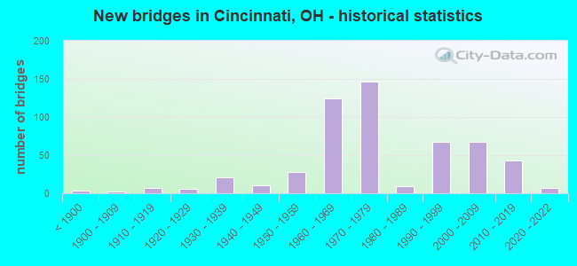
- New bridges - historical statistics
- 3Before 1900
- 21900-1909
- 71910-1919
- 61920-1929
- 211930-1939
- 111940-1949
- 281950-1959
- 1251960-1969
- 1471970-1979
- 91980-1989
- 681990-1999
- 672000-2009
- 432010-2019
- 72020-2022
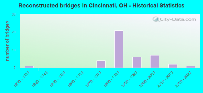
- Reconstructed bridges - Historical Statistics
- 11930-1939
- 01940-1949
- 01950-1959
- 01960-1969
- 41970-1979
- 211980-1989
- 61990-1999
- 72000-2009
- 22010-2019
- 12020-2022
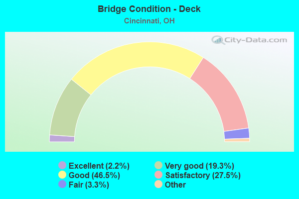
- Bridge Condition - Deck
- 2.2%Excellent
- 19.3%Very good
- 46.5%Good
- 27.5%Satisfactory
- 3.3%Fair
- 1.1%Poor
- 0.4%Serious
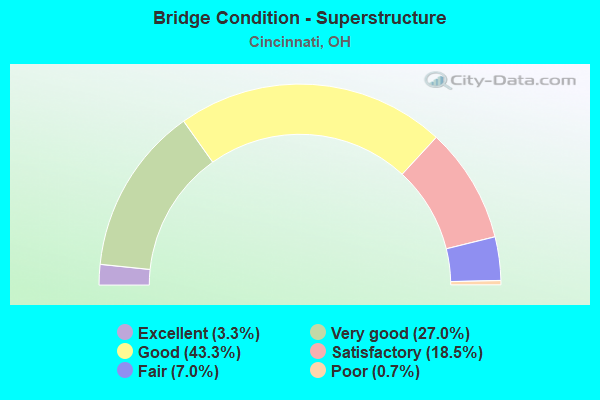
- Bridge Condition - Superstructure
- 3.3%Excellent
- 27.0%Very good
- 43.3%Good
- 18.5%Satisfactory
- 7.0%Fair
- 0.7%Poor
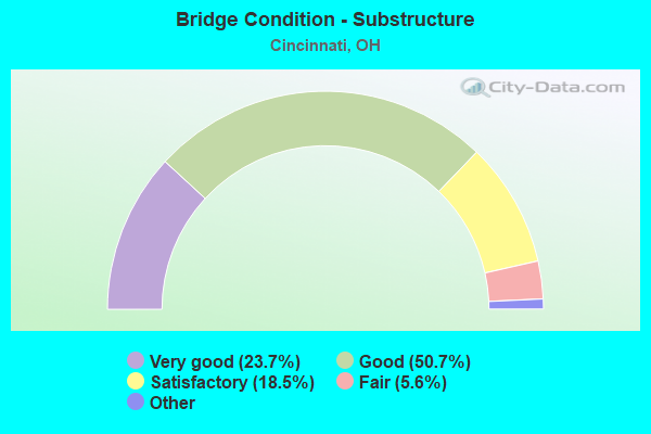
- Bridge Condition - Substructure
- 23.7%Excellent
- 50.7%Very good
- 18.5%Good
- 5.6%Satisfactory
- 1.5%Fair
- 0.7%Poor
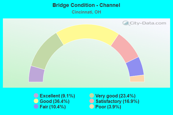
- Bridge Condition - Channel
- 9.1%Excellent
- 23.4%Very good
- 36.4%Good
- 16.9%Satisfactory
- 10.4%Fair
- 3.9%Poor
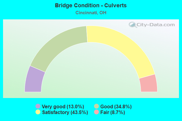
- Bridge Condition - Culverts
- 13.0%Very good
- 34.8%Good
- 43.5%Satisfactory
- 8.7%Fair
Find on map >> Show street view
Structure Number: 3115739, Location: .5 MI W OF IR 75 (Lat: 39.154161, Lng: -84.542781), Route carried "under" structure: US 27, Year Built: 1973, Structure Length: 0. m, Average Daily Traffic: 9,939 (year 2015), Truck Traffic: 6%, Features Intersected: I-74 E.B.
Minimum Vertical Clearance: 7.62m (25.00ft), Kilometerpoint: 9.093, Lanes on structure: 3, Lanes under structure: 7, Material/Design: Steel continuous, Design/Construction: Stringer/Multi-beam, Length of Maximum Span: 53.0m (173.9ft)
Find on map >> Show street view
Structure Number: 3115801, Location: OVER IR 74 EB[RAMP P&X] (Lat: 39.151500, Lng: -84.540831), Route carried "under" structure: Ramp Interstate 75, Year Built: 2020, Structure Length: 0. m, Average Daily Traffic: 5,642 (year 2019), Truck Traffic: 4%, Features Intersected: IR74 E RAMP TO IR75 N
Minimum Vertical Clearance: 4.83m (15.85ft), Kilometerpoint: 7.242, Lanes on structure: 1, Lanes under structure: 9, Material/Design: Steel continuous, Design/Construction: Girder and Floorbeam System, Length of Maximum Span: 51.8m (169.9ft)
Find on map >> Show street view
Structure Number: 3115801, Location: OVER IR 74 EB[RAMP P&X] (Lat: 39.151500, Lng: -84.540831), Route carried "under" structure: Interstate 75, Year Built: 2020, Structure Length: 0. m, Average Daily Traffic: 128,251 (year 2019), Truck Traffic: 14%, Features Intersected: IR74 E RAMP TO IR75 N
Minimum Vertical Clearance: 4.98m (16.34ft), Kilometerpoint: 7.197, Lanes on structure: 1, Lanes under structure: 9, Material/Design: Steel continuous, Design/Construction: Girder and Floorbeam System, Length of Maximum Span: 51.8m (169.9ft)
Find on map >> Show street view
Structure Number: 3115801, Location: OVER IR 74 EB[RAMP P&X] (Lat: 39.151500, Lng: -84.540831), Route carried "under" structure: Interstate 74, Year Built: 2020, Structure Length: 0. m, Average Daily Traffic: 90,131 (year 2019), Truck Traffic: 9%, Features Intersected: IR74 E RAMP
Minimum Vertical Clearance: 12.31m (40.39ft), Kilometerpoint: 31.022, Lanes on structure: 1, Lanes under structure: 9, Material/Design: Steel continuous, Design/Construction: Girder and Floorbeam System, Length of Maximum Span: 51.8m (169.9ft)
Find on map >> Show street view
Structure Number: 3117049, Location: .2 MI E OF IR 275 (Lat: 39.051811, Lng: -84.390269), Route carried "under" structure: County highway 504, Year Built: 1974, Structure Length: 0. m, Average Daily Traffic: 7,123 (year 2015), Truck Traffic: 5%, Features Intersected: US52*W, Facility Carried by Structure: US 52
Minimum Vertical Clearance: 4.60m (15.09ft), Kilometerpoint: 0.338, Lanes on structure: 2, Lanes under structure: 2, Material/Design: Steel continuous, Design/Construction: Stringer/Multi-beam, Length of Maximum Span: 18.3m (60.0ft)
Find on map >> Show street view
Structure Number: 3117162, Location: 1 MI W OF OH-KY LINE (Lat: 39.058339, Lng: -84.413339), Route carried "under" structure: County highway 382, Year Built: 1976, Structure Length: 0. m, Average Daily Traffic: 139 (year 2015), Truck Traffic: 6%, Features Intersected: I275*W, Facility Carried by Structure: WB IR 275
Minimum Vertical Clearance: 11.76m (38.58ft), Kilometerpoint: 0.483, Lanes on structure: 4, Lanes under structure: 2, Material/Design: Steel continuous, Design/Construction: Stringer/Multi-beam, Length of Maximum Span: 24.7m (81.0ft)
Find on map >> Show street view
Structure Number: 311717, Location: 1 MI W OF OH-KY LINE (Lat: 39.058581, Lng: -84.413161), Route carried "under" structure: County highway 382, Year Built: 1976, Structure Length: 0. m, Average Daily Traffic: 139 (year 2015), Truck Traffic: 6%, Features Intersected: I275*E, Facility Carried by Structure: EB IR 275
Minimum Vertical Clearance: 11.76m (38.58ft), Kilometerpoint: 0.515, Lanes on structure: 3, Lanes under structure: 2, Material/Design: Steel continuous, Design/Construction: Stringer/Multi-beam, Length of Maximum Span: 24.7m (81.0ft)
Find on map >> Show street view
Structure Number: 31172, Location: OVER US 52 KELLOGG AVE (Lat: 39.060361, Lng: -84.420889), Route carried "under" structure: US 52, Year Built: 1976, Structure Length: 0. m, Average Daily Traffic: 3,697 (year 2015), Truck Traffic: 4%, Features Intersected: I275*W, Facility Carried by Structure: WB IR 275
Minimum Vertical Clearance: 4.50m (14.76ft), Kilometerpoint: 54.380, Lanes on structure: 3, Lanes under structure: 5, Material/Design: Steel continuous, Design/Construction: Stringer/Multi-beam, Length of Maximum Span: 31.1m (102.0ft)
Find on map >> Show street view
Structure Number: 3117219, Location: OVER US 52 KELLOGG AVE (Lat: 39.060700, Lng: -84.421131), Route carried "under" structure: US 52, Year Built: 1976, Structure Length: 0. m, Average Daily Traffic: 7,394 (year 2015), Truck Traffic: 4%, Features Intersected: I275*E, Facility Carried by Structure: EB IR 275
Minimum Vertical Clearance: 5.18m (16.99ft), Kilometerpoint: 54.380, Lanes on structure: 4, Lanes under structure: 6, Material/Design: Steel continuous, Design/Construction: Stringer/Multi-beam, Length of Maximum Span: 30.9m (101.4ft)
Find on map >> Show street view
Structure Number: 3117332, Location: RAMP FROM EB 50 T0 471SB (Lat: 39.102311, Lng: -84.498619), Route carried "under" structure: County highway 738, Year Built: 2000, Structure Length: 0. m, Average Daily Traffic: 10,316 (year 2015), Truck Traffic: 5%, Features Intersected: IR 471, Facility Carried by Structure: RAMP R
Minimum Vertical Clearance: 7.62m (25.00ft), Kilometerpoint: 128.748, Lanes on structure: 2, Lanes under structure: 3, Material/Design: Steel continuous, Design/Construction: Box Beam or Girders - Multiple, Length of Maximum Span: 50.8m (166.7ft)
Find on map >> Show street view
Structure Number: 3117332, Location: RAMP FROM EB 50 T0 471SB (Lat: 39.102311, Lng: -84.498619), Route carried "under" structure: US 52, Year Built: 2000, Structure Length: 0. m, Average Daily Traffic: 7,600 (year 2013), Truck Traffic: 7%, Features Intersected: IR 471, Facility Carried by Structure: RAMP R
Minimum Vertical Clearance: 7.62m (25.00ft), Kilometerpoint: 40.781, Lanes on structure: 2, Lanes under structure: 3, Material/Design: Steel continuous, Design/Construction: Box Beam or Girders - Multiple, Length of Maximum Span: 50.8m (166.7ft)
Find on map >> Show street view
Structure Number: 3117359, Location: OH-KY STATE LINE (Lat: 39.101400, Lng: -84.496611), Route carried "under" structure: County highway C0741, Year Built: 1976, Structure Length: 0. m, Features Intersected: I471*S, Facility Carried by Structure: SB IR 471
Minimum Vertical Clearance: 4.72m (15.49ft), Kilometerpoint: 0.000, Lanes on structure: 4, Lanes under structure: 6, Material/Design: Steel continuous, Design/Construction: Stringer/Multi-beam, Length of Maximum Span: 31.4m (103.0ft)
Find on map >> Show street view
Structure Number: 3117359, Location: OH-KY STATE LINE (Lat: 39.101400, Lng: -84.496611), Route carried "under" structure: US 52, Year Built: 1976, Structure Length: 0. m, Average Daily Traffic: 7,187 (year 2015), Truck Traffic: 6%, Features Intersected: I471*S, Facility Carried by Structure: SB IR 471
Minimum Vertical Clearance: 9.02m (29.59ft), Kilometerpoint: 40.781, Lanes on structure: 4, Lanes under structure: 6, Material/Design: Steel continuous, Design/Construction: Stringer/Multi-beam, Length of Maximum Span: 31.4m (103.0ft)
Find on map >> Show street view
Structure Number: 3117359, Location: OH-KY STATE LINE (Lat: 39.101400, Lng: -84.496611), Route carried "under" structure: Ramp US 50, Year Built: 1976, Structure Length: 0. m, Features Intersected: I471*S, Facility Carried by Structure: SB IR 471
Minimum Vertical Clearance: 5.82m (19.09ft), Kilometerpoint: 35.261, Lanes on structure: 4, Lanes under structure: 6, Material/Design: Steel continuous, Design/Construction: Stringer/Multi-beam, Length of Maximum Span: 31.4m (103.0ft)
Find on map >> Show street view
Structure Number: 3117367, Location: OH-KY STATE LINE (Lat: 39.101539, Lng: -84.496481), Route carried "under" structure: Ramp US 50, Year Built: 1976, Structure Length: 0. m, Features Intersected: I471*N;RAMP=I471*N-US50, Facility Carried by Structure: NB IR 471
Minimum Vertical Clearance: 4.72m (15.49ft), Kilometerpoint: 35.277, Lanes on structure: 3, Lanes under structure: 6, Material/Design: Steel continuous, Design/Construction: Stringer/Multi-beam, Length of Maximum Span: 31.4m (103.0ft)
Find on map >> Show street view
Structure Number: 3117367, Location: OH-KY STATE LINE (Lat: 39.101539, Lng: -84.496481), Route carried "under" structure: US 52, Year Built: 1976, Structure Length: 0. m, Average Daily Traffic: 7,187 (year 2015), Truck Traffic: 6%, Features Intersected: I471*N;RAMP=I471*N-US50, Facility Carried by Structure: NB IR 471
Minimum Vertical Clearance: 7.77m (25.49ft), Kilometerpoint: 40.797, Lanes on structure: 3, Lanes under structure: 6, Material/Design: Steel continuous, Design/Construction: Stringer/Multi-beam, Length of Maximum Span: 31.4m (103.0ft)
Find on map >> Show street view
Structure Number: 3117367, Location: OH-KY STATE LINE (Lat: 39.101539, Lng: -84.496481), Route carried "under" structure: County highway C0741, Year Built: 1976, Structure Length: 0. m, Features Intersected: I471*N;RAMP=I471*N-US50, Facility Carried by Structure: NB IR 471
Minimum Vertical Clearance: 4.65m (15.26ft), Kilometerpoint: 0.000, Lanes on structure: 3, Lanes under structure: 6, Material/Design: Steel continuous, Design/Construction: Stringer/Multi-beam, Length of Maximum Span: 31.4m (103.0ft)
Find on map >> Show street view
Structure Number: 3117553, Location: .3 MI N OF OH-KY LINE (Lat: 39.103819, Lng: -84.499561), Route carried "under" structure: Ramp US 50, Year Built: 1985, Structure Length: 0. m, Average Daily Traffic: 1,000 (year 1900), Truck Traffic: 10%, Features Intersected: RMP=I471*N-US50*W,ST,RMP, Facility Carried by Structure: RAMP N IR471-6TH S
Minimum Vertical Clearance: 5.11m (16.77ft), Kilometerpoint: 35.373, Lanes on structure: 1, Lanes under structure: 4, Material/Design: Steel continuous, Design/Construction: Stringer/Multi-beam, Length of Maximum Span: 39.3m (128.9ft)
Find on map >> Show street view
Structure Number: 3117553, Location: .3 MI N OF OH-KY LINE (Lat: 39.103819, Lng: -84.499561), Route carried "under" structure: County highway MONST, Year Built: 1985, Structure Length: 0. m, Average Daily Traffic: 2,392 (year 2015), Truck Traffic: 2%, Features Intersected: RMP=I471*N-US50*W,ST,RMP, Facility Carried by Structure: RAMP N IR471-6TH S
Minimum Vertical Clearance: 8.38m (27.49ft), Kilometerpoint: 0.032, Lanes on structure: 1, Lanes under structure: 4, Material/Design: Steel continuous, Design/Construction: Stringer/Multi-beam, Length of Maximum Span: 39.3m (128.9ft)
Find on map >> Show street view
Structure Number: 311765, Location: .4 MI N OH-KY LINE (Lat: 39.105200, Lng: -84.503169), Route carried "under" structure: Ramp Interstate 471, Year Built: 1976, Structure Length: 0. m, Average Daily Traffic: 43,321 (year 2009), Truck Traffic: 4%, Features Intersected: IR471
Minimum Vertical Clearance: 6.71m (22.01ft), Kilometerpoint: 70.811, Lanes on structure: 2, Lanes under structure: 10, Material/Design: Steel continuous, Design/Construction: Stringer/Multi-beam, Length of Maximum Span: 38.1m (125.0ft)
Find on map >> Show street view
Structure Number: 3117677, Location: SBL DAN BEARD OVER OH RVR (Lat: 39.101289, Lng: -84.496019), Route carried "under" structure: City street 1000, Year Built: 1976, Structure Length: 0. m, Average Daily Traffic: 10 (year 2019), Truck Traffic: 10%, Features Intersected: IR-471, Facility Carried by Structure: KY RIVERBOAT RD
Minimum Vertical Clearance: 5.33m (17.49ft), Kilometerpoint: 0.000, Lanes on structure: 4, Lanes under structure: 2, Material/Design: Steel, Design/Construction: Arch - Thru, Length of Maximum Span: 231.0m (757.9ft)
Find on map >> Show street view
Structure Number: 311846, Location: SR126 OVER SR4 (Lat: 39.206100, Lng: -84.475681), Route carried "under" structure: State highway 4, Year Built: 1990, Structure Length: 0. m, Average Daily Traffic: 17,600 (year 2015), Truck Traffic: 5%, Features Intersected: SR 126, Facility Carried by Structure: SR 126
Minimum Vertical Clearance: 10.90m (35.76ft), Kilometerpoint: 5.601, Lanes on structure: 2, Lanes under structure: 2, Material/Design: Steel continuous, Design/Construction: Stringer/Multi-beam, Length of Maximum Span: 22.3m (73.2ft)
Find on map >> Show street view
Structure Number: 3118479, Location: SR 126 OVER SR 4 (Lat: 39.205950, Lng: -84.475850), Route carried "under" structure: State highway 4, Year Built: 1990, Structure Length: 0. m, Average Daily Traffic: 17,600 (year 2015), Truck Traffic: 5%, Features Intersected: SR 126, Facility Carried by Structure: SR 126
Minimum Vertical Clearance: 10.14m (33.27ft), Kilometerpoint: 5.568, Lanes on structure: 2, Lanes under structure: 2, Material/Design: Steel continuous, Design/Construction: Stringer/Multi-beam, Length of Maximum Span: 24.1m (79.1ft)
Find on map >> Show street view
Structure Number: 3118525, Location: SR 126 0VER IR 75 (Lat: 39.204739, Lng: -84.468131), Route carried "under" structure: Interstate 75, Year Built: 1990, Structure Length: 0. m, Average Daily Traffic: 131,227 (year 2015), Truck Traffic: 16%, Features Intersected: SR 126, Facility Carried by Structure: ON RP. TO WB 126
Minimum Vertical Clearance: 5.79m (19.00ft), Kilometerpoint: 16.608, Lanes on structure: 1, Lanes under structure: 7, Material/Design: Steel continuous, Design/Construction: Stringer/Multi-beam, Length of Maximum Span: 32.9m (107.9ft)
Find on map >> Show street view
Structure Number: 3118533, Location: SR 126 OVER IR 75 (Lat: 39.204719, Lng: -84.468139), Route carried "under" structure: Interstate 75, Year Built: 1990, Structure Length: 0. m, Average Daily Traffic: 131,227 (year 2015), Truck Traffic: 16%, Features Intersected: SR 126, Facility Carried by Structure: CROSS CNTY HWY
Minimum Vertical Clearance: 7.52m (24.67ft), Kilometerpoint: 16.576, Lanes on structure: 3, Lanes under structure: 7, Material/Design: Steel continuous, Design/Construction: Stringer/Multi-beam, Length of Maximum Span: 33.5m (109.9ft)
Find on map >> Show street view
Structure Number: 3118533, Location: SR 126 OVER IR 75 (Lat: 39.204719, Lng: -84.468139), Route carried "under" structure: City street CO604, Year Built: 1990, Structure Length: 0. m, Average Daily Traffic: 2 (year 1994), Truck Traffic: 50%, Features Intersected: SR 126, Facility Carried by Structure: CROSS CNTY HWY
Minimum Vertical Clearance: 11.25m (36.91ft), Kilometerpoint: 15.546, Lanes on structure: 3, Lanes under structure: 7, Material/Design: Steel continuous, Design/Construction: Stringer/Multi-beam, Length of Maximum Span: 33.5m (109.9ft)
Find on map >> Show street view
Structure Number: 3118614, Location: WB SR 126 OVER SB I75 (Lat: 39.210439, Lng: -84.462569), Route carried "under" structure: Interstate 75, Year Built: 1990, Structure Length: 0. m, Average Daily Traffic: 122,553 (year 2015), Truck Traffic: 16%, Features Intersected: SR 126, Facility Carried by Structure: S.R. 126
Minimum Vertical Clearance: 7.62m (25.00ft), Kilometerpoint: 17.349, Lanes on structure: 2, Lanes under structure: 6, Material/Design: Steel continuous, Design/Construction: Stringer/Multi-beam, Length of Maximum Span: 26.5m (86.9ft)
Find on map >> Show street view
Structure Number: 311863, Location: WB SR126 OVER NB I-75 (Lat: 39.210581, Lng: -84.460719), Route carried "under" structure: Interstate 75, Year Built: 1990, Structure Length: 0. m, Average Daily Traffic: 122,553 (year 2015), Truck Traffic: 16%, Features Intersected: SR 126, Facility Carried by Structure: SR 126
Minimum Vertical Clearance: 4.90m (16.08ft), Kilometerpoint: 17.477, Lanes on structure: 2, Lanes under structure: 3, Material/Design: Steel continuous, Design/Construction: Stringer/Multi-beam, Length of Maximum Span: 39.6m (129.9ft)
Find on map >> Show street view
Structure Number: 3136337, Location: .4MI W OF I75&HOPPLE OPAS (Lat: 39.137419, Lng: -84.544131), Route carried "under" structure: City street SPGRV, Year Built: 1916, Structure Length: 0. m, Average Daily Traffic: 19,710 (year 1967), Features Intersected: HOPPLE(SPR/GRV-MLL CR&RR, Facility Carried by Structure: HOPPLE STREET
Minimum Vertical Clearance: 4.78m (15.68ft), Kilometerpoint: 2.173, Lanes on structure: 4, Lanes under structure: 5, Material/Design: Prestressed concrete, Design/Construction: Stringer/Multi-beam, Length of Maximum Span: 23.8m (78.1ft)
Find on map >> Show street view
Structure Number: 3136582, Location: Viaduct W OF INT DALTON (Lat: 39.105100, Lng: -84.550889), Route carried "under" structure: City street EVANS, Year Built: 1929, Structure Length: 0. m, Average Daily Traffic: 1,800 (year 1990), Features Intersected: EIGHTH ST VIADUCT, Facility Carried by Structure: EIGHTH STREET
Minimum Vertical Clearance: 6.55m (21.49ft), Kilometerpoint: 0.000, Lanes on structure: 4, Lanes under structure: 2, Material/Design: Steel, Design/Construction: Girder and Floorbeam System, Length of Maximum Span: 22.9m (75.1ft)
Find on map >> Show street view
Structure Number: 3136612, Location: 600' W OF I-75 UND PASS (Lat: 39.211869, Lng: -84.463539), Route carried "under" structure: City street ANTHY, Year Built: 1949, Structure Length: 0. m, Average Daily Traffic: 8,400 (year 1990), Features Intersected: GALBRAITH RD, Facility Carried by Structure: GALBRAITH ROAD
Minimum Vertical Clearance: 8.23m (27.00ft), Kilometerpoint: 0.000, Lanes on structure: 4, Lanes under structure: 3, Material/Design: Steel continuous, Design/Construction: Stringer/Multi-beam, Length of Maximum Span: 25.9m (85.0ft)
Find on map >> Show street view
Structure Number: 3136795, Location: 0.3 MI E OF INT US27&NBEN (Lat: 39.192731, Lng: -84.567589), Route carried "under" structure: City street KIRBY, Year Built: 1951, Structure Length: 0. m, Average Daily Traffic: 1,800 (year 1990), Truck Traffic: 1%, Features Intersected: NORTH BEND RD, Facility Carried by Structure: NORTH BEND ROAD
Minimum Vertical Clearance: 4.22m (13.85ft), Kilometerpoint: 0.000, Lanes on structure: 4, Lanes under structure: 2, Material/Design: Steel continuous, Design/Construction: Stringer/Multi-beam, Length of Maximum Span: 14.9m (48.9ft)
Find on map >> Show street view
Structure Number: 3137082, Location: 620 ft W of Central Pkwy (Lat: 39.124700, Lng: -84.540839), Route carried "under" structure: City street SPRNG, Year Built: 1931, Structure Length: 0. m, Average Daily Traffic: 16,650 (year 1987), Truck Traffic: 6%, Features Intersected: WESTERN HILLS VIADUCT, Facility Carried by Structure: WESTERN HILLS VIAD
Minimum Vertical Clearance: 6.76m (22.18ft), Kilometerpoint: 0.644, Lanes on structure: 4, Lanes under structure: 5, Material/Design: Steel, Design/Construction: Girder and Floorbeam System, Length of Maximum Span: 36.6m (120.1ft)
Find on map >> Show street view
Structure Number: 3160076, Location: 0.1 MI N OF MONASTERY ST (Lat: 39.108850, Lng: -84.499181), Route carried "under" structure: City street WARHM, Year Built: 1931, Structure Length: 0. m, Average Daily Traffic: 575 (year 1991), Truck Traffic: 4%, Features Intersected: IDA STREET, Facility Carried by Structure: WAREHAM STREET
Minimum Vertical Clearance: 10.97m (35.99ft), Kilometerpoint: 53.913, Lanes on structure: 2, Lanes under structure: 2, Material/Design: Concrete, Design/Construction: Arch - Deck, Length of Maximum Span: 39.0m (128.0ft)
Find on map >> Show street view
Structure Number: 316013, Location: AT INT GILBERT & KENTON (Lat: 39.121311, Lng: -84.494461), Route carried "under" structure: City street FLORN, Year Built: 1998, Structure Length: 0. m, Average Daily Traffic: 1,500 (year 1998), Truck Traffic: 1%, Features Intersected: KENTON AVENUE, Facility Carried by Structure: FLORENCE AVENUE
Minimum Vertical Clearance: 10.36m (33.99ft), Kilometerpoint: 54.090, Lanes on structure: 2, Lanes under structure: 2, Material/Design: Steel continuous, Design/Construction: Stringer/Multi-beam, Length of Maximum Span: 29.0m (95.1ft)
Find on map >> Show street view
Structure Number: 3160726, Location: 0.2 MI S OF PARK & KEMPER (Lat: 39.117181, Lng: -84.489389), Route carried "under" structure: City street EDEN, Year Built: 1949, Structure Length: 0. m, Average Daily Traffic: 7,000 (year 1991), Truck Traffic: 5%, Features Intersected: CLIFF STREET
Minimum Vertical Clearance: 7.93m (26.02ft), Kilometerpoint: 59.723, Lanes on structure: 1, Lanes under structure: 4, Material/Design: Concrete, Design/Construction: Arch - Deck, Length of Maximum Span: 21.3m (69.9ft)
Find on map >> Show street view
Structure Number: 3160777, Location: INT KEMPER LN & PARK AVE (Lat: 39.119169, Lng: -84.487389), Route carried "under" structure: County highway 751, Year Built: 1917, Structure Length: 0. m, Average Daily Traffic: 10,316 (year 2015), Truck Traffic: 5%, Features Intersected: EDEN PARK DRIVE, Facility Carried by Structure: KEMPER LANE
Minimum Vertical Clearance: 10.97m (35.99ft), Kilometerpoint: 59.739, Lanes on structure: 4, Lanes under structure: 2, Material/Design: Concrete, Design/Construction: Arch - Deck, Length of Maximum Span: 54.9m (180.1ft)
Find on map >> Show street view
Structure Number: 3160998, Location: 0.1 MI E OF ROSSLYN DR (Lat: 39.150100, Lng: -84.404611), Route carried "under" structure: County highway 67, Year Built: 1943, Structure Length: 0. m, Average Daily Traffic: 19,808 (year 2015), Truck Traffic: 8%, Features Intersected: ERIE AVE BRIDGE CR-608
Minimum Vertical Clearance: 5.66m (18.57ft), Kilometerpoint: 73.080, Lanes on structure: 5, Lanes under structure: 4, Material/Design: Steel continuous, Design/Construction: Stringer/Multi-beam, Length of Maximum Span: 19.2m (63.0ft)
Find on map >> Show street view
Structure Number: 3161978, Location: SOUTH OF 2ND & ELM INT. (Lat: 39.096161, Lng: -84.514269), Route carried "under" structure: City street PROSE, Year Built: 2000, Structure Length: 0. m, Average Daily Traffic: 1,000 (year 2000), Truck Traffic: 5%, Features Intersected: ELM STREET, Facility Carried by Structure: PETE ROSE WAY & PA
Minimum Vertical Clearance: 5.49m (18.01ft), Kilometerpoint: 2.575, Lanes on structure: 4, Lanes under structure: 2, Material/Design: Concrete continuous, Design/Construction: Slab, Length of Maximum Span: 10.7m (35.1ft)
Find on map >> Show street view
Structure Number: 3162656, Location: AT WOODLAWN&W.8TH OVERPAS (Lat: 39.105700, Lng: -84.567850), Route carried "under" structure: City street WOODL, Year Built: 1955, Structure Length: 0. m, Average Daily Traffic: 1,000 (year 1991), Truck Traffic: 5%, Features Intersected: W EIGHTH ST BRIDGE
Minimum Vertical Clearance: 4.70m (15.42ft), Kilometerpoint: 46.381, Lanes on structure: 4, Lanes under structure: 2, Material/Design: Steel, Design/Construction: Stringer/Multi-beam, Length of Maximum Span: 16.2m (53.1ft)
Find on map >> Show street view
Structure Number: 3162702, Location: AT INT OF FAIRBANKS&W8TH (Lat: 39.105789, Lng: -84.569089), Route carried "under" structure: City street FAIRB, Year Built: 1955, Structure Length: 0. m, Average Daily Traffic: 1,000 (year 1991), Truck Traffic: 5%, Features Intersected: W EIGHTH ST BRIDGE
Minimum Vertical Clearance: 7.32m (24.02ft), Kilometerpoint: 46.365, Lanes on structure: 4, Lanes under structure: 2, Material/Design: Steel continuous, Design/Construction: Stringer/Multi-beam, Length of Maximum Span: 15.9m (52.2ft)
Find on map >> Show street view
Structure Number: 3177685, Location: NBL DAN BEARD OVER OH RVR (Lat: 39.101139, Lng: -84.496181), Route carried "under" structure: City street 1000, Year Built: 1976, Structure Length: 0. m, Average Daily Traffic: 10 (year 2019), Truck Traffic: 10%, Features Intersected: IR-471, Facility Carried by Structure: KY RIVERBOAT ROW
Minimum Vertical Clearance: 5.33m (17.49ft), Kilometerpoint: 0.000, Lanes on structure: 4, Lanes under structure: 2, Material/Design: Steel, Design/Construction: Arch - Thru, Length of Maximum Span: 231.0m (757.9ft)