Bridge Statistics for Cincinnati, Ohio (OH)
Condition, Traffic, Stress, Structural Evaluation, Project Costs
- National Bridge Inventory (NBI) Statistics
- 544Number of bridges
- 11,909ft / 3,630mTotal length
- $14,821,000Total costs
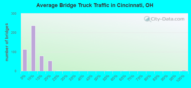
- 17,264,432Total average daily traffic
- 1,896,147Total average daily truck traffic
- National Bridge Inventory (NBI) Registered Bridges for Cincinnati
- No street view available for this location
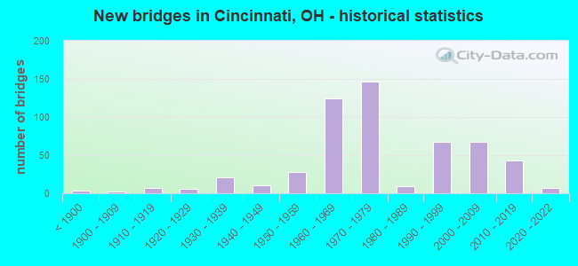
- New bridges - historical statistics
- 3Before 1900
- 21900-1909
- 71910-1919
- 61920-1929
- 211930-1939
- 111940-1949
- 281950-1959
- 1251960-1969
- 1471970-1979
- 91980-1989
- 681990-1999
- 672000-2009
- 432010-2019
- 72020-2022
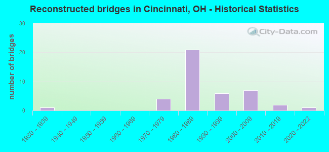
- Reconstructed bridges - Historical Statistics
- 11930-1939
- 01940-1949
- 01950-1959
- 01960-1969
- 41970-1979
- 211980-1989
- 61990-1999
- 72000-2009
- 22010-2019
- 12020-2022
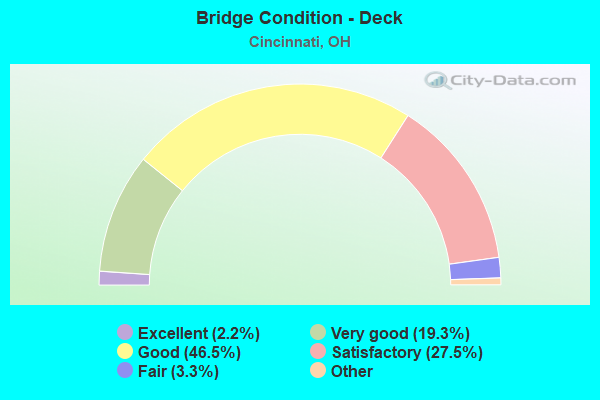
- Bridge Condition - Deck
- 2.2%Excellent
- 19.3%Very good
- 46.5%Good
- 27.5%Satisfactory
- 3.3%Fair
- 1.1%Poor
- 0.4%Serious
- Bridge Condition - Superstructure
- 3.3%Excellent
- 27.0%Very good
- 43.3%Good
- 18.5%Satisfactory
- 7.0%Fair
- 0.7%Poor
- Bridge Condition - Substructure
- 23.7%Excellent
- 50.7%Very good
- 18.5%Good
- 5.6%Satisfactory
- 1.5%Fair
- 0.7%Poor
- Bridge Condition - Channel
- 9.1%Excellent
- 23.4%Very good
- 36.4%Good
- 16.9%Satisfactory
- 10.4%Fair
- 3.9%Poor
- Bridge Condition - Culverts
- 13.0%Very good
- 34.8%Good
- 43.5%Satisfactory
- 8.7%Fair
Find on map >> Show street view
Structure Number: 3106683, Location: .1 MI N OF IR471 (Lat: 39.110381, Lng: -84.501411), Route carried "under" structure: US 22, Year Built: 1976, Structure Length: 0. m, Average Daily Traffic: 11,050 (year 2013), Truck Traffic: 7%, Features Intersected: I71;US22(S3);CRR;RAMP, Facility Carried by Structure: RAMP-I471N-US42W
Minimum Vertical Clearance: 6.61m (21.69ft), Kilometerpoint: 1.191, Lanes on structure: 1, Lanes under structure: 8, Material/Design: Steel continuous, Design/Construction: Stringer/Multi-beam, Length of Maximum Span: 32.9m (107.9ft)
Find on map >> Show street view
Structure Number: 3106683, Location: .1 MI N OF IR471 (Lat: 39.110381, Lng: -84.501411), Route carried "under" structure: Ramp US RAMP, Year Built: 1976, Structure Length: 0. m, Features Intersected: I71;US22(S3);CRR;RAMP
Minimum Vertical Clearance: 6.17m (20.24ft), Kilometerpoint: 1.191, Lanes on structure: 1, Lanes under structure: 8, Material/Design: Steel continuous, Design/Construction: Stringer/Multi-beam, Length of Maximum Span: 32.9m (107.9ft)
Find on map >> Show street view
Structure Number: 3106721, Location: .07 MI N OF US 22 GILBERT (Lat: 39.113081, Lng: -84.500739), Route carried "under" structure: Interstate 71, Year Built: 1970, Structure Length: 0. m, Average Daily Traffic: 97,834 (year 2015), Truck Traffic: 14%, Features Intersected: ELSINORE PLACE, Facility Carried by Structure: ELSINORE PLACE
Minimum Vertical Clearance: 4.62m (15.16ft), Kilometerpoint: 3.637, Lanes on structure: 3, Lanes under structure: 6, Material/Design: Steel continuous, Design/Construction: Stringer/Multi-beam, Length of Maximum Span: 27.1m (88.9ft)
Find on map >> Show street view
Structure Number: 3106756, Location: US42 RAMP OVER IR 71 (Lat: 39.113889, Lng: -84.500639), Route carried "under" structure: Interstate 71, Year Built: 1970, Structure Length: 0. m, Average Daily Traffic: 97,834 (year 2015), Truck Traffic: 14%, Features Intersected: RAMP=FR-US42- NB-71
Minimum Vertical Clearance: 5.66m (18.57ft), Kilometerpoint: 3.750, Lanes on structure: 2, Lanes under structure: 8, Material/Design: Steel continuous, Design/Construction: Stringer/Multi-beam, Length of Maximum Span: 43.0m (141.1ft)
Find on map >> Show street view
Structure Number: 310678, Location: .2 MI N OF US 42 (Lat: 39.116511, Lng: -84.500500), Route carried "under" structure: US 42, Year Built: 1970, Structure Length: 0. m, Average Daily Traffic: 12,760 (year 2015), Truck Traffic: 7%, Features Intersected: I71*S, Facility Carried by Structure: SB IR 71
Minimum Vertical Clearance: 10.08m (33.07ft), Kilometerpoint: 42.004, Lanes on structure: 4, Lanes under structure: 7, Material/Design: Steel, Design/Construction: Girder and Floorbeam System, Length of Maximum Span: 43.3m (142.1ft)
Find on map >> Show street view
Structure Number: 3106802, Location: .2 MI N OF US 42 (Lat: 39.116089, Lng: -84.499839), Route carried "under" structure: City street FLORN, Year Built: 1970, Structure Length: 0. m, Average Daily Traffic: 100 (year 1970), Truck Traffic: 99%, Features Intersected: I71*N, Facility Carried by Structure: NB IR 71
Minimum Vertical Clearance: 4.57m (14.99ft), Kilometerpoint: 0.000, Lanes on structure: 4, Lanes under structure: 6, Material/Design: Steel, Design/Construction: Girder and Floorbeam System, Length of Maximum Span: 40.8m (133.9ft)
Find on map >> Show street view
Structure Number: 3108791, Location: .2 MI N OF OH-KY LINE (Lat: 39.095619, Lng: -84.522361), Route carried "under" structure: County highway C0758, Year Built: 1963, Structure Length: 0. m, Average Daily Traffic: 19,457 (year 2015), Truck Traffic: 7%, Features Intersected: I75*S, Facility Carried by Structure: SB IR 75
Minimum Vertical Clearance: 6.10m (20.01ft), Kilometerpoint: 0.415, Lanes on structure: 2, Lanes under structure: 4, Material/Design: Steel continuous, Design/Construction: Stringer/Multi-beam, Length of Maximum Span: 23.8m (78.1ft)
Find on map >> Show street view
Structure Number: 3108805, Location: .2 MI N OF OH-KY LINE (Lat: 39.096000, Lng: -84.522050), Route carried "under" structure: Interstate 75, Year Built: 1963, Structure Length: 0. m, Average Daily Traffic: 116,070 (year 2009), Truck Traffic: 13%, Features Intersected: IR 75 NB
Minimum Vertical Clearance: 4.42m (14.50ft), Kilometerpoint: 56.327, Lanes on structure: 3, Lanes under structure: 6, Material/Design: Steel continuous, Design/Construction: Stringer/Multi-beam, Length of Maximum Span: 35.7m (117.1ft)
Find on map >> Show street view
Structure Number: 3108805, Location: .2 MI N OF OH-KY LINE (Lat: 39.096000, Lng: -84.522050), Route carried "under" structure: US 42, Year Built: 1963, Structure Length: 0. m, Average Daily Traffic: 6,740 (year 2013), Truck Traffic: 7%, Features Intersected: IR 75 NB, Facility Carried by Structure: NB IR 75
Minimum Vertical Clearance: 7.62m (25.00ft), Kilometerpoint: 0.499, Lanes on structure: 3, Lanes under structure: 6, Material/Design: Steel continuous, Design/Construction: Stringer/Multi-beam, Length of Maximum Span: 35.7m (117.1ft)
Find on map >> Show street view
Structure Number: 3108805, Location: .2 MI N OF OH-KY LINE (Lat: 39.096000, Lng: -84.522050), Route carried "under" structure: Ramp Interstate 75, Year Built: 1963, Structure Length: 0. m, Average Daily Traffic: 94,100 (year 2005), Truck Traffic: 9%, Features Intersected: IR 75 NB
Minimum Vertical Clearance: 4.93m (16.17ft), Kilometerpoint: 51.499, Lanes on structure: 3, Lanes under structure: 6, Material/Design: Steel continuous, Design/Construction: Stringer/Multi-beam, Length of Maximum Span: 35.7m (117.1ft)
Find on map >> Show street view
Structure Number: 3108872, Location: .3MI N OF STATE LINE (Lat: 39.097639, Lng: -84.521500), Route carried "under" structure: Interstate 75, Year Built: 1998, Structure Length: 0. m, Average Daily Traffic: 108,580 (year 2013), Truck Traffic: 14%, Features Intersected: IR 75
Minimum Vertical Clearance: 4.93m (16.17ft), Kilometerpoint: 0.628, Lanes on structure: 1, Lanes under structure: 4, Material/Design: Steel continuous, Design/Construction: Stringer/Multi-beam, Length of Maximum Span: 21.2m (69.6ft)
Find on map >> Show street view
Structure Number: 3108872, Location: .3MI N OF STATE LINE (Lat: 39.097639, Lng: -84.521500), Route carried "under" structure: US 50, Year Built: 1998, Structure Length: 0. m, Average Daily Traffic: 13,902 (year 2015), Truck Traffic: 6%, Features Intersected: IR 75 RAMP J, Facility Carried by Structure: IR75 RAMP TO SR264
Minimum Vertical Clearance: 5.01m (16.44ft), Kilometerpoint: 33.008, Lanes on structure: 1, Lanes under structure: 4, Material/Design: Steel continuous, Design/Construction: Stringer/Multi-beam, Length of Maximum Span: 21.2m (69.6ft)
Find on map >> Show street view
Structure Number: 3108945, Location: .1 MI N OF SR 264D (Lat: 39.102281, Lng: -84.523150), Route carried "under" structure: Interstate 75, Year Built: 1963, Structure Length: 0. m, Average Daily Traffic: 29,114 (year 2015), Truck Traffic: 16%, Features Intersected: IR 75, Facility Carried by Structure: SEVENTH STREET
Minimum Vertical Clearance: 5.26m (17.26ft), Kilometerpoint: 1.127, Lanes on structure: 4, Lanes under structure: 4, Material/Design: Steel continuous, Design/Construction: Stringer/Multi-beam, Length of Maximum Span: 45.1m (148.0ft)
Find on map >> Show street view
Structure Number: 3109003, Location: OVER IR 75/.6 MI N I71 (Lat: 39.103169, Lng: -84.525619), Route carried "under" structure: Ramp Interstate 75, Year Built: 1963, Structure Length: 0. m, Average Daily Traffic: 150,420 (year 2009), Truck Traffic: 10%, Features Intersected: I75*S RAMP;NINTH ST*W, Facility Carried by Structure: NINTH ST RAMP
Minimum Vertical Clearance: 4.98m (16.34ft), Kilometerpoint: 1.384, Lanes on structure: 1, Lanes under structure: 3, Material/Design: Steel continuous, Design/Construction: Stringer/Multi-beam, Length of Maximum Span: 36.6m (120.1ft)
Find on map >> Show street view
Structure Number: 3109038, Location: .3 MI N OF SR 264 DA (Lat: 39.103419, Lng: -84.525789), Route carried "under" structure: Interstate 75, Year Built: 1963, Structure Length: 0. m, Average Daily Traffic: 145,897 (year 2015), Truck Traffic: 16%, Features Intersected: IR 75; Ramp; Gest Str., Facility Carried by Structure: NINTH ST
Minimum Vertical Clearance: 5.13m (16.83ft), Kilometerpoint: 1.432, Lanes on structure: 2, Lanes under structure: 6, Material/Design: Steel continuous, Design/Construction: Stringer/Multi-beam, Length of Maximum Span: 36.9m (121.1ft)
Find on map >> Show street view
Structure Number: 3109062, Location: .3 MI N OF SR 264DA (Lat: 39.103089, Lng: -84.527181), Route carried "under" structure: City street GEST, Year Built: 1963, Structure Length: 0. m, Average Daily Traffic: 17,669 (year 2015), Truck Traffic: 7%, Features Intersected: EIGHTH STREET*E, Facility Carried by Structure: I-75 7TH ST.
Minimum Vertical Clearance: 5.56m (18.24ft), Kilometerpoint: 2.414, Lanes on structure: 2, Lanes under structure: 2, Material/Design: Steel continuous, Design/Construction: Stringer/Multi-beam, Length of Maximum Span: 22.3m (73.2ft)
Find on map >> Show street view
Structure Number: 3109097, Location: .5 MI N OF SR 264 (Lat: 39.104131, Lng: -84.529050), Route carried "under" structure: Interstate 75, Year Built: 1961, Structure Length: 0. m, Average Daily Traffic: 129,291 (year 2017), Truck Traffic: 10%, Features Intersected: LINN STREET, Facility Carried by Structure: LINN STREET
Minimum Vertical Clearance: 5.03m (16.50ft), Kilometerpoint: 1.691, Lanes on structure: 6, Lanes under structure: 6, Material/Design: Steel continuous, Design/Construction: Stringer/Multi-beam, Length of Maximum Span: 25.9m (85.0ft)
Find on map >> Show street view
Structure Number: 3109097, Location: .5 MI N OF SR 264 (Lat: 39.104131, Lng: -84.529050), Route carried "under" structure: Ramp City street WINCH, Year Built: 1961, Structure Length: 0. m, Average Daily Traffic: 6,399 (year 2017), Truck Traffic: 1%, Features Intersected: LINN STREET, Facility Carried by Structure: LINN STREET
Minimum Vertical Clearance: 4.70m (15.42ft), Kilometerpoint: 0.192, Lanes on structure: 6, Lanes under structure: 6, Material/Design: Steel continuous, Design/Construction: Stringer/Multi-beam, Length of Maximum Span: 25.9m (85.0ft)
Find on map >> Show street view
Structure Number: 3109097, Location: .5 MI N OF SR 264 (Lat: 39.104131, Lng: -84.529050), Route carried "under" structure: City street GEST, Year Built: 1961, Structure Length: 0. m, Average Daily Traffic: 7,951 (year 2017), Truck Traffic: 15%, Features Intersected: LINN STREET, Facility Carried by Structure: LINN STREET
Minimum Vertical Clearance: 4.57m (14.99ft), Kilometerpoint: 2.095, Lanes on structure: 6, Lanes under structure: 6, Material/Design: Steel continuous, Design/Construction: Stringer/Multi-beam, Length of Maximum Span: 25.9m (85.0ft)
Find on map >> Show street view
Structure Number: 3109127, Location: .8 MI N OF SR 264 (Lat: 39.106750, Lng: -84.531100), Route carried "under" structure: Interstate 75, Year Built: 1961, Structure Length: 0. m, Average Daily Traffic: 137,856 (year 2015), Truck Traffic: 16%, Features Intersected: Ramp to SB IR75
Minimum Vertical Clearance: 4.72m (15.49ft), Kilometerpoint: 2.012, Lanes on structure: 2, Lanes under structure: 6, Material/Design: Steel continuous, Design/Construction: Stringer/Multi-beam, Length of Maximum Span: 36.0m (118.1ft)
Find on map >> Show street view
Structure Number: 3109186, Location: .8 MI N OF SR 264 (Lat: 39.106911, Lng: -84.531800), Route carried "under" structure: Ramp Interstate 75, Year Built: 1961, Structure Length: 0. m, Average Daily Traffic: 156,302 (year 2009), Truck Traffic: 11%, Features Intersected: SB*RAMP*UND*RAMP*
Minimum Vertical Clearance: 4.57m (14.99ft), Kilometerpoint: 20.278, Lanes on structure: 2, Lanes under structure: 2, Material/Design: Steel, Design/Construction: Stringer/Multi-beam, Length of Maximum Span: 21.3m (69.9ft)
Find on map >> Show street view
Structure Number: 3109216, Location: .9 MI N OF SR 264 (Lat: 39.109761, Lng: -84.531861), Route carried "under" structure: Interstate 75, Year Built: 1961, Structure Length: 0. m, Average Daily Traffic: 136,897 (year 2015), Truck Traffic: 16%, Features Intersected: IR 75, Facility Carried by Structure: EZZARD CHAS DR EB
Minimum Vertical Clearance: 4.72m (15.49ft), Kilometerpoint: 2.301, Lanes on structure: 2, Lanes under structure: 6, Material/Design: Steel continuous, Design/Construction: Stringer/Multi-beam, Length of Maximum Span: 25.6m (84.0ft)
Find on map >> Show street view
Structure Number: 310924, Location: .9 MI N OF SR 264 (Lat: 39.109450, Lng: -84.531889), Route carried "under" structure: Interstate 75, Year Built: 1961, Structure Length: 0. m, Average Daily Traffic: 136,897 (year 2015), Truck Traffic: 16%, Features Intersected: IR 75, Facility Carried by Structure: EZZARD CHAS DR WB
Minimum Vertical Clearance: 4.65m (15.26ft), Kilometerpoint: 2.350, Lanes on structure: 2, Lanes under structure: 6, Material/Design: Steel continuous, Design/Construction: Stringer/Multi-beam, Length of Maximum Span: 25.9m (85.0ft)
Find on map >> Show street view
Structure Number: 3109275, Location: 1.2 MI N OF SR 264 (Lat: 39.113589, Lng: -84.531611), Route carried "under" structure: City street LIBTY, Year Built: 1961, Structure Length: 0. m, Average Daily Traffic: 28,319 (year 2015), Truck Traffic: 7%, Features Intersected: I75, Facility Carried by Structure: IR 75
Minimum Vertical Clearance: 4.78m (15.68ft), Kilometerpoint: 0.322, Lanes on structure: 6, Lanes under structure: 6, Material/Design: Steel continuous, Design/Construction: Stringer/Multi-beam, Length of Maximum Span: 16.8m (55.1ft)
Find on map >> Show street view
Structure Number: 3109305, Location: 1.4 MI N OF SR 264 (Lat: 39.116031, Lng: -84.533111), Route carried "under" structure: City street FINLY, Year Built: 1961, Structure Length: 0. m, Average Daily Traffic: 10,316 (year 2015), Truck Traffic: 5%, Features Intersected: I75, Facility Carried by Structure: IR 75
Minimum Vertical Clearance: 4.50m (14.76ft), Kilometerpoint: 0.322, Lanes on structure: 6, Lanes under structure: 4, Material/Design: Steel continuous, Design/Construction: Stringer/Multi-beam, Length of Maximum Span: 21.6m (70.9ft)
Find on map >> Show street view
Structure Number: 3109364, Location: 1.3 MI S OF US 52 (Lat: 39.119619, Lng: -84.535389), Route carried "under" structure: City street BANK, Year Built: 1961, Structure Length: 0. m, Average Daily Traffic: 18,124 (year 2015), Truck Traffic: 7%, Features Intersected: I75, Facility Carried by Structure: IR 75
Minimum Vertical Clearance: 4.62m (15.16ft), Kilometerpoint: 0.161, Lanes on structure: 6, Lanes under structure: 6, Material/Design: Steel continuous, Design/Construction: Stringer/Multi-beam, Length of Maximum Span: 15.5m (50.9ft)
Find on map >> Show street view
Structure Number: 3109399, Location: 1.1 MI S OF US 52 (Lat: 39.122661, Lng: -84.535631), Route carried "under" structure: City street HARSN, Year Built: 1961, Structure Length: 0. m, Average Daily Traffic: 10,316 (year 2015), Truck Traffic: 5%, Features Intersected: I75*S, Facility Carried by Structure: SB IR 75
Minimum Vertical Clearance: 5.64m (18.50ft), Kilometerpoint: 7.725, Lanes on structure: 4, Lanes under structure: 4, Material/Design: Steel continuous, Design/Construction: Stringer/Multi-beam, Length of Maximum Span: 19.8m (65.0ft)
Find on map >> Show street view
Structure Number: 3109429, Location: 1.1 MI S OF US 52 (Lat: 39.122600, Lng: -84.535300), Route carried "under" structure: City street HARSN, Year Built: 1961, Structure Length: 0. m, Average Daily Traffic: 10,316 (year 2015), Truck Traffic: 5%, Features Intersected: I75*N, Facility Carried by Structure: NB IR 75
Minimum Vertical Clearance: 4.60m (15.09ft), Kilometerpoint: 7.757, Lanes on structure: 4, Lanes under structure: 4, Material/Design: Steel continuous, Design/Construction: Stringer/Multi-beam, Length of Maximum Span: 19.5m (64.0ft)
Find on map >> Show street view
Structure Number: 3109453, Location: 1 MI S OF US 52 (Lat: 39.123900, Lng: -84.535839), Route carried "under" structure: City street SPRNG, Year Built: 1963, Structure Length: 0. m, Average Daily Traffic: 8,557 (year 2015), Truck Traffic: 7%, Features Intersected: RAMP=US52*E-I75*S, Facility Carried by Structure: I-75-WH VIAD.I-75S
Minimum Vertical Clearance: 4.50m (14.76ft), Kilometerpoint: 0.483, Lanes on structure: 1, Lanes under structure: 6, Material/Design: Steel continuous, Design/Construction: Stringer/Multi-beam, Length of Maximum Span: 32.9m (107.9ft)
Find on map >> Show street view
Structure Number: 3109488, Location: .9 MI S OF US 52 (Lat: 39.124869, Lng: -84.536311), Route carried "under" structure: City street SPRNG, Year Built: 1963, Structure Length: 0. m, Average Daily Traffic: 9,870 (year 2015), Truck Traffic: 7%, Features Intersected: RAMP=I75*S-US52*W, Facility Carried by Structure: I75S-W HILLS VIADU
Minimum Vertical Clearance: 4.52m (14.83ft), Kilometerpoint: 0.547, Lanes on structure: 1, Lanes under structure: 4, Material/Design: Steel continuous, Design/Construction: Stringer/Multi-beam, Length of Maximum Span: 32.0m (105.0ft)
Find on map >> Show street view
Structure Number: 3109518, Location: .8 MI S OF US 52 (Lat: 39.125539, Lng: -84.534961), Route carried "under" structure: Interstate 75, Year Built: 1961, Structure Length: 0. m, Average Daily Traffic: 70,261 (year 2015), Truck Traffic: 16%, Features Intersected: RMP=IR75*NWES HILS VIA*W
Minimum Vertical Clearance: 4.55m (14.93ft), Kilometerpoint: 4.200, Lanes on structure: 2, Lanes under structure: 4, Material/Design: Steel continuous, Design/Construction: Stringer/Multi-beam, Length of Maximum Span: 31.7m (104.0ft)
Find on map >> Show street view
Structure Number: 3109569, Location: .5 MI S OF US 52 (Lat: 39.131950, Lng: -84.532711), Route carried "under" structure: City street MARSL, Year Built: 2013, Structure Length: 0. m, Features Intersected: I75, Facility Carried by Structure: IR 75
Minimum Vertical Clearance: 4.52m (14.83ft), Kilometerpoint: 0.322, Lanes on structure: 11, Lanes under structure: 4, Material/Design: Steel, Design/Construction: Stringer/Multi-beam, Length of Maximum Span: 27.4m (89.9ft)
Find on map >> Show street view
Structure Number: 3109704, Location: .2 MI N US 27 (Lat: 39.143050, Lng: -84.536081), Route carried "under" structure: Interstate 75, Year Built: 2010, Structure Length: 0. m, Average Daily Traffic: 149,132 (year 2015), Truck Traffic: 16%, Features Intersected: IR 75, Facility Carried by Structure: MONMOUTH ST.
Minimum Vertical Clearance: 5.08m (16.67ft), Kilometerpoint: 6.196, Lanes on structure: 2, Lanes under structure: 9, Material/Design: Steel, Design/Construction: Stringer/Multi-beam, Length of Maximum Span: 48.9m (160.4ft)
Find on map >> Show street view
Structure Number: 3109763, Location: At I-74/75 interchange (Lat: 39.150461, Lng: -84.540011), Route carried "under" structure: Interstate 74, Year Built: 2020, Structure Length: 0. m, Average Daily Traffic: 29,891 (year 2019), Truck Traffic: 5%, Features Intersected: IR75
Minimum Vertical Clearance: 4.95m (16.24ft), Kilometerpoint: 31.117, Lanes on structure: 8, Lanes under structure: 2, Material/Design: Prestressed concrete continuous, Design/Construction: Stringer/Multi-beam, Length of Maximum Span: 27.0m (88.6ft)
Find on map >> Show street view
Structure Number: 3109887, Location: 1.7 MI N OF IR 74 (Lat: 39.162019, Lng: -84.516531), Route carried "under" structure: City street CLIFN, Year Built: 2013, Structure Length: 0. m, Average Daily Traffic: 4,691 (year 2015), Truck Traffic: 9%, Features Intersected: IR75, Facility Carried by Structure: IR 75
Minimum Vertical Clearance: 5.31m (17.42ft), Kilometerpoint: 9.737, Lanes on structure: 9, Lanes under structure: 2, Material/Design: Prestressed concrete continuous, Design/Construction: Stringer/Multi-beam, Length of Maximum Span: 28.8m (94.5ft)
Find on map >> Show street view
Structure Number: 3109941, Location: 1.4 MI S OF SR 562 (Lat: 39.162911, Lng: -84.509111), Route carried "under" structure: City street MITCL, Year Built: 2013, Structure Length: 0. m, Average Daily Traffic: 32,271 (year 2015), Truck Traffic: 4%, Features Intersected: IR 75, Facility Carried by Structure: IR 75
Minimum Vertical Clearance: 4.83m (15.85ft), Kilometerpoint: 0.000, Lanes on structure: 8, Lanes under structure: 4, Material/Design: Steel continuous, Design/Construction: Stringer/Multi-beam, Length of Maximum Span: 43.4m (142.4ft)
Find on map >> Show street view
Structure Number: 3110002, Location: .21 MI N OF MARTIN LUTHER (Lat: 39.136069, Lng: -84.489669), Route carried "under" structure: City street 2778, Year Built: 2016, Structure Length: 0. m, Average Daily Traffic: 2,010 (year 2016), Truck Traffic: 6%, Features Intersected: IR71, Facility Carried by Structure: I71 Rmp A frm NB71
Minimum Vertical Clearance: 4.91m (16.11ft), Kilometerpoint: 6.470, Lanes on structure: 1, Lanes under structure: 2, Material/Design: Concrete, Design/Construction: Culvert, Length of Maximum Span: 14.6m (47.9ft)
Find on map >> Show street view
Structure Number: 3110036, Location: OVER SR 562 EB RAMP (Lat: 39.175261, Lng: -84.488761), Route carried "under" structure: Ramp State highway 562, Year Built: 1959, Structure Length: 0. m, Average Daily Traffic: 65,990 (year 2009), Truck Traffic: 7%, Features Intersected: IR-75, Facility Carried by Structure: IR 75
Minimum Vertical Clearance: 4.67m (15.32ft), Kilometerpoint: 4.828, Lanes on structure: 6, Lanes under structure: 2, Material/Design: Steel continuous, Design/Construction: Stringer/Multi-beam, Length of Maximum Span: 15.5m (50.9ft)
Find on map >> Show street view
Structure Number: 3110087, Location: .3 MI N OF SR 562 (Lat: 39.179061, Lng: -84.486311), Route carried "under" structure: City street LAIDL, Year Built: 1959, Structure Length: 0. m, Average Daily Traffic: 5,104 (year 2015), Truck Traffic: 11%, Features Intersected: I75, Facility Carried by Structure: IR 75
Minimum Vertical Clearance: 4.42m (14.50ft), Kilometerpoint: 0.032, Lanes on structure: 6, Lanes under structure: 4, Material/Design: Steel continuous, Design/Construction: Stringer/Multi-beam, Length of Maximum Span: 18.3m (60.0ft)
Find on map >> Show street view
Structure Number: 3110176, Location: .7 MI S OF SR 561 (Lat: 39.183519, Lng: -84.483919), Route carried "under" structure: County highway 603, Year Built: 1958, Structure Length: 0. m, Average Daily Traffic: 10,699 (year 2015), Truck Traffic: 7%, Features Intersected: I75, Facility Carried by Structure: IR 75
Minimum Vertical Clearance: 4.62m (15.16ft), Kilometerpoint: 32.187, Lanes on structure: 6, Lanes under structure: 4, Material/Design: Steel continuous, Design/Construction: Stringer/Multi-beam, Length of Maximum Span: 20.7m (67.9ft)
Find on map >> Show street view
Structure Number: 3111385, Location: OVER I 75 (Lat: 39.154131, Lng: -84.537969), Route carried "under" structure: Interstate 75, Year Built: 1994, Structure Length: 0. m, Average Daily Traffic: 129,511 (year 2015), Truck Traffic: 16%, Features Intersected: LUDLOW, US 127, Facility Carried by Structure: US 127
Minimum Vertical Clearance: 6.38m (20.93ft), Kilometerpoint: 75.961, Lanes on structure: 4, Lanes under structure: 6, Material/Design: Steel continuous, Design/Construction: Stringer/Multi-beam, Length of Maximum Span: 54.0m (177.2ft)
Find on map >> Show street view
Structure Number: 3111636, Location: 500 ft N of jct w US50 (Lat: 39.102550, Lng: -84.554281), Route carried "under" structure: State highway 264, Year Built: 2014, Structure Length: 0. m, Average Daily Traffic: 6,227 (year 2015), Truck Traffic: 3%, Features Intersected: SR264W to Warsaw, Facility Carried by Structure: WB Warsaw Ave Ramp
Minimum Vertical Clearance: 5.54m (18.18ft), Kilometerpoint: 23.303, Lanes on structure: 1, Lanes under structure: 3, Material/Design: Steel continuous, Design/Construction: Stringer/Multi-beam, Length of Maximum Span: 46.5m (152.6ft)
Find on map >> Show street view
Structure Number: 3111644, Location: OVER SB IR 71& EB US 50 (Lat: 39.100531, Lng: -84.523150), Route carried "under" structure: Interstate 75, Year Built: 1963, Structure Length: 0. m, Average Daily Traffic: 29,114 (year 2015), Truck Traffic: 16%, Features Intersected: SR 264, Facility Carried by Structure: SR 264
Minimum Vertical Clearance: 4.83m (15.85ft), Kilometerpoint: 0.810, Lanes on structure: 2, Lanes under structure: 7, Material/Design: Steel continuous, Design/Construction: Stringer/Multi-beam, Length of Maximum Span: 32.6m (107.0ft)
Find on map >> Show street view
Structure Number: 3111644, Location: OVER SB IR 71& EB US 50 (Lat: 39.100531, Lng: -84.523150), Route carried "under" structure: Ramp US 50, Year Built: 1963, Structure Length: 0. m, Features Intersected: SR 264, Facility Carried by Structure: SR 264
Minimum Vertical Clearance: 4.80m (15.75ft), Kilometerpoint: 32.911, Lanes on structure: 2, Lanes under structure: 7, Material/Design: Steel continuous, Design/Construction: Stringer/Multi-beam, Length of Maximum Span: 32.6m (107.0ft)
Find on map >> Show street view
Structure Number: 3111644, Location: OVER SB IR 71& EB US 50 (Lat: 39.100531, Lng: -84.523150), Route carried "under" structure: Ramp US 50, Year Built: 1963, Structure Length: 0. m, Features Intersected: SR 264, Facility Carried by Structure: SR 264
Minimum Vertical Clearance: 4.57m (14.99ft), Kilometerpoint: 32.895, Lanes on structure: 2, Lanes under structure: 7, Material/Design: Steel continuous, Design/Construction: Stringer/Multi-beam, Length of Maximum Span: 32.6m (107.0ft)
Find on map >> Show street view
Structure Number: 3111644, Location: OVER SB IR 71& EB US 50 (Lat: 39.100531, Lng: -84.523150), Route carried "under" structure: US 50, Year Built: 1963, Structure Length: 0. m, Average Daily Traffic: 53,510 (year 2013), Truck Traffic: 7%, Features Intersected: SR 264, Facility Carried by Structure: SR 264
Minimum Vertical Clearance: 5.26m (17.26ft), Kilometerpoint: 32.943, Lanes on structure: 2, Lanes under structure: 7, Material/Design: Steel continuous, Design/Construction: Stringer/Multi-beam, Length of Maximum Span: 32.6m (107.0ft)
Find on map >> Show street view
Structure Number: 3111644, Location: OVER SB IR 71& EB US 50 (Lat: 39.100531, Lng: -84.523150), Route carried "under" structure: Ramp Interstate 75, Year Built: 1963, Structure Length: 0. m, Features Intersected: SR 264, Facility Carried by Structure: SR 264
Minimum Vertical Clearance: 4.37m (14.34ft), Kilometerpoint: 80.467, Lanes on structure: 2, Lanes under structure: 7, Material/Design: Steel continuous, Design/Construction: Stringer/Multi-beam, Length of Maximum Span: 32.6m (107.0ft)
Find on map >> Show street view
Structure Number: 3111652, Location: junctions with US 50 (Lat: 39.101581, Lng: -84.553131), Route carried "under" structure: Ramp State highway ELBER, Year Built: 2014, Structure Length: 0. m, Features Intersected: Ramp US50W to Elberon, Facility Carried by Structure: WB Elberon Ramp
Minimum Vertical Clearance: 6.00m (19.69ft), Kilometerpoint: 0.000, Lanes on structure: 1, Lanes under structure: 2, Material/Design: Steel continuous, Design/Construction: Stringer/Multi-beam, Length of Maximum Span: 38.1m (125.0ft)
Find on map >> Show street view
Structure Number: 3111652, Location: junctions with US 50 (Lat: 39.101581, Lng: -84.553131), Route carried "under" structure: State highway 264, Year Built: 2014, Structure Length: 0. m, Features Intersected: Ramp US50W to Elberon, Facility Carried by Structure: WB Elberon Ramp
Minimum Vertical Clearance: 6.40m (21.00ft), Kilometerpoint: 23.432, Lanes on structure: 1, Lanes under structure: 2, Material/Design: Steel continuous, Design/Construction: Stringer/Multi-beam, Length of Maximum Span: 38.1m (125.0ft)
Find on map >> Show street view
Structure Number: 3111652, Location: junctions with US 50 (Lat: 39.101581, Lng: -84.553131), Route carried "under" structure: City street MARYL, Year Built: 2014, Structure Length: 0. m, Average Daily Traffic: 1,949 (year 2015), Truck Traffic: 5%, Features Intersected: Ramp US50W to Elberon, Facility Carried by Structure: WB Elberon Ramp
Minimum Vertical Clearance: 5.59m (18.34ft), Kilometerpoint: 0.000, Lanes on structure: 1, Lanes under structure: 2, Material/Design: Steel continuous, Design/Construction: Stringer/Multi-beam, Length of Maximum Span: 38.1m (125.0ft)
Find on map >> Show street view
Structure Number: 3111679, Location: OVER NB IR 75 (Lat: 39.099919, Lng: -84.521389), Route carried "under" structure: Interstate 75, Year Built: 1963, Structure Length: 0. m, Average Daily Traffic: 14,557 (year 2015), Truck Traffic: 16%, Features Intersected: S264*E, Facility Carried by Structure: SR 264
Minimum Vertical Clearance: 4.44m (14.57ft), Kilometerpoint: 80.467, Lanes on structure: 3, Lanes under structure: 3, Material/Design: Steel continuous, Design/Construction: Stringer/Multi-beam, Length of Maximum Span: 19.5m (64.0ft)
Find on map >> Show street view
Structure Number: 3111709, Location: .05 MI. W. OF CENTRAL AVE (Lat: 39.100111, Lng: -84.520331), Route carried "under" structure: Interstate 75, Year Built: 1963, Structure Length: 0. m, Average Daily Traffic: 99,810 (year 2013), Truck Traffic: 15%, Features Intersected: SR 264, Facility Carried by Structure: SR 264
Minimum Vertical Clearance: 4.44m (14.57ft), Kilometerpoint: 0.789, Lanes on structure: 3, Lanes under structure: 5, Material/Design: Steel continuous, Design/Construction: Stringer/Multi-beam, Length of Maximum Span: 24.1m (79.1ft)
Find on map >> Show street view
Structure Number: 3111709, Location: .05 MI. W. OF CENTRAL AVE (Lat: 39.100111, Lng: -84.520331), Route carried "under" structure: US 50, Year Built: 1963, Structure Length: 0. m, Average Daily Traffic: 13,902 (year 2015), Truck Traffic: 6%, Features Intersected: SR 264, Facility Carried by Structure: SR 264
Minimum Vertical Clearance: 4.60m (15.09ft), Kilometerpoint: 32.927, Lanes on structure: 3, Lanes under structure: 5, Material/Design: Steel continuous, Design/Construction: Stringer/Multi-beam, Length of Maximum Span: 24.1m (79.1ft)
Find on map >> Show street view
Structure Number: 3111709, Location: .05 MI. W. OF CENTRAL AVE (Lat: 39.100111, Lng: -84.520331), Route carried "under" structure: Interstate 75, Year Built: 1963, Structure Length: 0. m, Average Daily Traffic: 89,930 (year 2013), Truck Traffic: 15%, Features Intersected: SR 264, Facility Carried by Structure: SR 264
Minimum Vertical Clearance: 4.60m (15.09ft), Kilometerpoint: 0.805, Lanes on structure: 3, Lanes under structure: 5, Material/Design: Steel continuous, Design/Construction: Stringer/Multi-beam, Length of Maximum Span: 24.1m (79.1ft)
Find on map >> Show street view
Structure Number: 3111733, Location: OVER I 75 (Lat: 39.101611, Lng: -84.521539), Route carried "under" structure: Interstate 75, Year Built: 1963, Structure Length: 0. m, Average Daily Traffic: 14,557 (year 2015), Truck Traffic: 16%, Features Intersected: SR 264 WB TO 50 WB
Minimum Vertical Clearance: 4.55m (14.93ft), Kilometerpoint: 101.389, Lanes on structure: 2, Lanes under structure: 3, Material/Design: Steel continuous, Design/Construction: Stringer/Multi-beam, Length of Maximum Span: 27.1m (88.9ft)
Find on map >> Show street view
Structure Number: 3113736, Location: OVER I-75 (Lat: 39.192939, Lng: -84.477350), Route carried "under" structure: Interstate 75, Year Built: 2018, Structure Length: 0. m, Average Daily Traffic: 137,280 (year 2015), Truck Traffic: 16%, Features Intersected: SR 561 SEYMOUR AVE, Facility Carried by Structure: SR 561 (Seymour A
Minimum Vertical Clearance: 5.12m (16.80ft), Kilometerpoint: 149.830, Lanes on structure: 3, Lanes under structure: 7, Material/Design: Steel continuous, Design/Construction: Stringer/Multi-beam, Length of Maximum Span: 37.2m (122.0ft)
Find on map >> Show street view
Structure Number: 3113779, Location: OVER IR 75 (Lat: 39.175250, Lng: -84.489261), Route carried "under" structure: Interstate 75, Year Built: 1962, Structure Length: 0. m, Average Daily Traffic: 114,257 (year 2015), Truck Traffic: 16%, Features Intersected: SR562
Minimum Vertical Clearance: 4.80m (15.75ft), Kilometerpoint: 127.621, Lanes on structure: 1, Lanes under structure: 6, Material/Design: Steel continuous, Design/Construction: Stringer/Multi-beam, Length of Maximum Span: 24.4m (80.1ft)
Find on map >> Show street view
Structure Number: 3113841, Location: OVER SR 4 (Lat: 39.173500, Lng: -84.478119), Route carried "under" structure: State highway 4, Year Built: 1959, Structure Length: 0. m, Average Daily Traffic: 20,089 (year 2015), Truck Traffic: 5%, Features Intersected: S562, Facility Carried by Structure: SR 562
Minimum Vertical Clearance: 4.72m (15.49ft), Kilometerpoint: 19.312, Lanes on structure: 4, Lanes under structure: 4, Material/Design: Steel continuous, Design/Construction: Stringer/Multi-beam, Length of Maximum Span: 25.9m (85.0ft)
Find on map >> Show street view
Structure Number: 3113884, Location: OVER US 42 (Lat: 39.170000, Lng: -84.469261), Route carried "under" structure: US 42, Year Built: 1972, Structure Length: 0. m, Average Daily Traffic: 22,753 (year 2015), Truck Traffic: 9%, Features Intersected: S562, Facility Carried by Structure: SR 562
Minimum Vertical Clearance: 4.55m (14.93ft), Kilometerpoint: 111.367, Lanes on structure: 4, Lanes under structure: 2, Material/Design: Steel continuous, Design/Construction: Stringer/Multi-beam, Length of Maximum Span: 30.2m (99.1ft)
Find on map >> Show street view
Structure Number: 3114236, Location: .6 MI N OF US 42 (Lat: 39.122611, Lng: -84.497861), Route carried "under" structure: Interstate 71, Year Built: 1972, Structure Length: 0. m, Average Daily Traffic: 98,076 (year 2015), Truck Traffic: 14%, Features Intersected: IR 71, Facility Carried by Structure: McGregor Ave.
Minimum Vertical Clearance: 7.57m (24.84ft), Kilometerpoint: 4.731, Lanes on structure: 3, Lanes under structure: 9, Material/Design: Steel continuous, Design/Construction: Stringer/Multi-beam, Length of Maximum Span: 32.3m (106.0ft)
Find on map >> Show street view
Structure Number: 311426, Location: .12MI S. OF WM.HOWARD TAF (Lat: 39.126400, Lng: -84.497550), Route carried "under" structure: Interstate 71, Year Built: 1972, Structure Length: 0. m, Average Daily Traffic: 98,076 (year 2015), Truck Traffic: 14%, Features Intersected: MCMILLAN STREET CR-605, Facility Carried by Structure: MCMILLIAN ST.
Minimum Vertical Clearance: 8.31m (27.26ft), Kilometerpoint: 5.150, Lanes on structure: 3, Lanes under structure: 9, Material/Design: Steel continuous, Design/Construction: Stringer/Multi-beam, Length of Maximum Span: 27.4m (89.9ft)
Find on map >> Show street view
Structure Number: 3114325, Location: .9 MI N OF US 42 (Lat: 39.127939, Lng: -84.496081), Route carried "under" structure: Interstate 71, Year Built: 1972, Structure Length: 0. m, Average Daily Traffic: 98,076 (year 2015), Truck Traffic: 14%, Features Intersected: WILLIAM HOWARD TAFT ROAD, Facility Carried by Structure: WM H. TAFT RD
Minimum Vertical Clearance: 7.29m (23.92ft), Kilometerpoint: 5.343, Lanes on structure: 4, Lanes under structure: 9, Material/Design: Steel continuous, Design/Construction: Stringer/Multi-beam, Length of Maximum Span: 37.5m (123.0ft)
Find on map >> Show street view
Structure Number: 3114368, Location: 1.1 MI N OF US 42 (Lat: 39.129669, Lng: -84.496039), Route carried "under" structure: Interstate 71, Year Built: 1972, Structure Length: 0. m, Average Daily Traffic: 98,076 (year 2015), Truck Traffic: 14%, Features Intersected: OAK STREET, Facility Carried by Structure: OAK ST
Minimum Vertical Clearance: 5.72m (18.77ft), Kilometerpoint: 5.536, Lanes on structure: 4, Lanes under structure: 9, Material/Design: Steel continuous, Design/Construction: Stringer/Multi-beam, Length of Maximum Span: 33.5m (109.9ft)
Find on map >> Show street view
Structure Number: 3114392, Location: 1.3 MI N OF US 42 (Lat: 39.132750, Lng: -84.494819), Route carried "under" structure: Interstate 71, Year Built: 1972, Structure Length: 0. m, Average Daily Traffic: 5,989 (year 2015), Truck Traffic: 5%, Features Intersected: IR71 U/ LINCOLN CR-663, Facility Carried by Structure: LINCOLN AVE CR-663
Minimum Vertical Clearance: 5.36m (17.59ft), Kilometerpoint: 5.906, Lanes on structure: 4, Lanes under structure: 11, Material/Design: Steel continuous, Design/Construction: Stringer/Multi-beam, Length of Maximum Span: 30.8m (101.0ft)
Find on map >> Show street view
Structure Number: 3114422, Location: 1.5MI N OF US42 OVER IR71 (Lat: 39.134750, Lng: -84.493819), Route carried "under" structure: Interstate 71, Year Built: 1972, Structure Length: 0. m, Average Daily Traffic: 125,546 (year 2015), Truck Traffic: 14%, Features Intersected: MARTIN LUTHER KING, Facility Carried by Structure: DR MARTN LUTH KING
Minimum Vertical Clearance: 9.09m (29.82ft), Kilometerpoint: 38.624, Lanes on structure: 6, Lanes under structure: 10, Material/Design: Steel continuous, Design/Construction: Stringer/Multi-beam, Length of Maximum Span: 31.7m (104.0ft)
Find on map >> Show street view
Structure Number: 3114422, Location: 1.5MI N OF US42 OVER IR71 (Lat: 39.134750, Lng: -84.493819), Route carried "under" structure: City street 2778, Year Built: 1972, Structure Length: 0. m, Average Daily Traffic: 2,010 (year 2015), Truck Traffic: 6%, Features Intersected: Martin Luther King Dr., Facility Carried by Structure: DR MARTN LUTH KING
Minimum Vertical Clearance: 4.42m (14.50ft), Kilometerpoint: 0.929, Lanes on structure: 6, Lanes under structure: 10, Material/Design: Steel continuous, Design/Construction: Stringer/Multi-beam, Length of Maximum Span: 31.7m (104.0ft)
Find on map >> Show street view
Structure Number: 3114422, Location: 1.5MI N OF US42 OVER IR71 (Lat: 39.134750, Lng: -84.493819), Route carried "under" structure: City street 2953, Year Built: 1972, Structure Length: 0. m, Features Intersected: Martin Luther King, Facility Carried by Structure: DR MARTN LUTH KING
Minimum Vertical Clearance: 5.94m (19.49ft), Kilometerpoint: 0.011, Lanes on structure: 6, Lanes under structure: 10, Material/Design: Steel continuous, Design/Construction: Stringer/Multi-beam, Length of Maximum Span: 31.7m (104.0ft)
Find on map >> Show street view
Structure Number: 3114465, Location: 1.5 MI N OF US 42 (Lat: 39.136500, Lng: -84.490239), Route carried "under" structure: Interstate 71, Year Built: 2015, Structure Length: 0. m, Average Daily Traffic: 125,546 (year 2015), Truck Traffic: 14%, Features Intersected: Stanton Ave. (Fredonia), Facility Carried by Structure: Stanton Ave.
Minimum Vertical Clearance: 6.10m (20.01ft), Kilometerpoint: 6.532, Lanes on structure: 2, Lanes under structure: 10, Material/Design: Prestressed concrete continuous, Design/Construction: Stringer/Multi-beam, Length of Maximum Span: 23.2m (76.1ft)
Find on map >> Show street view
Structure Number: 3114465, Location: 1.5 MI N OF US 42 (Lat: 39.136500, Lng: -84.490239), Route carried "under" structure: City street 1301, Year Built: 2015, Structure Length: 0. m, Features Intersected: IR71, Facility Carried by Structure: Stanton Ave.
Minimum Vertical Clearance: 0.00m, Lanes on structure: 2, Lanes under structure: 10, Material/Design: Prestressed concrete continuous, Design/Construction: Stringer/Multi-beam, Length of Maximum Span: 23.2m (76.1ft)
Find on map >> Show street view
Structure Number: 3114538, Location: 1.9 MI N OF US 42 READING (Lat: 39.140250, Lng: -84.487261), Route carried "under" structure: Interstate 71, Year Built: 1972, Structure Length: 0. m, Average Daily Traffic: 125,546 (year 2015), Truck Traffic: 14%, Features Intersected: BLAIR AVENUE, Facility Carried by Structure: BLAIR AVE
Minimum Vertical Clearance: 7.62m (25.00ft), Kilometerpoint: 6.872, Lanes on structure: 2, Lanes under structure: 10, Material/Design: Steel continuous, Design/Construction: Stringer/Multi-beam, Length of Maximum Span: 36.3m (119.1ft)
Find on map >> Show street view
Structure Number: 3114562, Location: 2.1 MI N OF US 42 READING (Lat: 39.141219, Lng: -84.483669), Route carried "under" structure: County highway 674, Year Built: 1972, Structure Length: 0. m, Average Daily Traffic: 13,979 (year 2015), Truck Traffic: 1%, Features Intersected: IR71, Facility Carried by Structure: IR 71
Minimum Vertical Clearance: 4.83m (15.85ft), Kilometerpoint: 0.161, Lanes on structure: 10, Lanes under structure: 6, Material/Design: Steel continuous, Design/Construction: Stringer/Multi-beam, Length of Maximum Span: 33.8m (110.9ft)
Find on map >> Show street view
Structure Number: 31146, Location: 2.7 MI N OF US 42 (Lat: 39.143661, Lng: -84.474931), Route carried "under" structure: Interstate 71, Year Built: 1972, Structure Length: 0. m, Average Daily Traffic: 125,546 (year 2015), Truck Traffic: 14%, Features Intersected: WOODBURN AVENUE, Facility Carried by Structure: WOODBURN AVE
Minimum Vertical Clearance: 6.46m (21.19ft), Kilometerpoint: 8.127, Lanes on structure: 4, Lanes under structure: 9, Material/Design: Steel continuous, Design/Construction: Stringer/Multi-beam, Length of Maximum Span: 30.2m (99.1ft)
Find on map >> Show street view
Structure Number: 3114643, Location: 1.4 MI S OF SR 561 (Lat: 39.142939, Lng: -84.466461), Route carried "under" structure: Interstate 71, Year Built: 1972, Structure Length: 0. m, Average Daily Traffic: 115,258 (year 2015), Truck Traffic: 14%, Features Intersected: TRIMBLE AVENUE, Facility Carried by Structure: TRIMBLE RD
Minimum Vertical Clearance: 5.03m (16.50ft), Kilometerpoint: 8.867, Lanes on structure: 4, Lanes under structure: 8, Material/Design: Steel continuous, Design/Construction: Stringer/Multi-beam, Length of Maximum Span: 28.0m (91.9ft)
Find on map >> Show street view
Structure Number: 3114716, Location: .9 MI S OF SR 561 (Lat: 39.144750, Lng: -84.457239), Route carried "under" structure: Interstate 71, Year Built: 1972, Structure Length: 0. m, Average Daily Traffic: 115,258 (year 2015), Truck Traffic: 14%, Features Intersected: DANA AVENUE, Facility Carried by Structure: DANA AVE
Minimum Vertical Clearance: 4.70m (15.42ft), Kilometerpoint: 9.704, Lanes on structure: 2, Lanes under structure: 8, Material/Design: Steel continuous, Design/Construction: Stringer/Multi-beam, Length of Maximum Span: 24.7m (81.0ft)
Find on map >> Show street view
Structure Number: 3115038, Location: OVER SR 562 RAMPS (Lat: 39.164181, Lng: -84.433700), Route carried "under" structure: State highway 562, Year Built: 1972, Structure Length: 0. m, Average Daily Traffic: 6,006 (year 2015), Truck Traffic: 5%, Features Intersected: I71*S, Facility Carried by Structure: IR 71 SB
Minimum Vertical Clearance: 7.62m (25.00ft), Kilometerpoint: 52.465, Lanes on structure: 4, Lanes under structure: 3, Material/Design: Steel continuous, Design/Construction: Stringer/Multi-beam, Length of Maximum Span: 43.9m (144.0ft)
Find on map >> Show street view
Structure Number: 3115062, Location: OVER IR 71 (Lat: 39.164311, Lng: -84.431269), Route carried "under" structure: Interstate 71, Year Built: 1972, Structure Length: 0. m, Average Daily Traffic: 59,696 (year 2015), Truck Traffic: 14%, Features Intersected: SR562 RMPSFOR 2AVE,I71*N
Minimum Vertical Clearance: 4.57m (14.99ft), Kilometerpoint: 12.939, Lanes on structure: 4, Lanes under structure: 5, Material/Design: Steel continuous, Design/Construction: Stringer/Multi-beam, Length of Maximum Span: 29.6m (97.1ft)
Find on map >> Show street view
Structure Number: 3115135, Location: .2 MI N OF SR 562 (Lat: 39.164939, Lng: -84.428100), Route carried "under" structure: Interstate 71, Year Built: 1972, Structure Length: 0. m, Average Daily Traffic: 61,159 (year 2015), Truck Traffic: 14%, Features Intersected: SB ON RAMP FROM RIDGE
Minimum Vertical Clearance: 4.95m (16.24ft), Kilometerpoint: 13.229, Lanes on structure: 1, Lanes under structure: 4, Material/Design: Steel, Design/Construction: Girder and Floorbeam System, Length of Maximum Span: 56.4m (185.0ft)
Find on map >> Show street view
Structure Number: 3115224, Location: .6 MI N OF SR 562 (Lat: 39.165211, Lng: -84.422900), Route carried "under" structure: City street RIDGE, Year Built: 1972, Structure Length: 0. m, Average Daily Traffic: 23,256 (year 2015), Truck Traffic: 5%, Features Intersected: RMP=B AVE*N-S562*W,I71*S
Minimum Vertical Clearance: 4.47m (14.67ft), Kilometerpoint: 1.609, Lanes on structure: 2, Lanes under structure: 5, Material/Design: Steel continuous, Design/Construction: Stringer/Multi-beam, Length of Maximum Span: 27.7m (90.9ft)
Find on map >> Show street view
Structure Number: 3115259, Location: .6 MI N OF SR 562 (Lat: 39.166919, Lng: -84.423311), Route carried "under" structure: Interstate 71, Year Built: 1972, Structure Length: 0. m, Average Daily Traffic: 122,317 (year 2015), Truck Traffic: 14%, Features Intersected: C275(RIDGE ROAD), Facility Carried by Structure: RIDGE RD C275
Minimum Vertical Clearance: 5.85m (19.19ft), Kilometerpoint: 13.696, Lanes on structure: 4, Lanes under structure: 6, Material/Design: Steel continuous, Design/Construction: Stringer/Multi-beam, Length of Maximum Span: 29.3m (96.1ft)
Find on map >> Show street view
Structure Number: 3115283, Location: .8 MI N OF SR 562 (Lat: 39.169619, Lng: -84.420061), Route carried "under" structure: Interstate 71, Year Built: 1972, Structure Length: 0. m, Average Daily Traffic: 127,004 (year 2015), Truck Traffic: 14%, Features Intersected: C339(KENNEDY AVENUE), Facility Carried by Structure: KENNEDY AVE C339
Minimum Vertical Clearance: 5.54m (18.18ft), Kilometerpoint: 14.082, Lanes on structure: 4, Lanes under structure: 7, Material/Design: Steel continuous, Design/Construction: Stringer/Multi-beam, Length of Maximum Span: 32.6m (107.0ft)
Find on map >> Show street view
Structure Number: 3115313, Location: 1.7 MI N OF SR 562 (Lat: 39.171219, Lng: -84.402950), Route carried "under" structure: County highway 331, Year Built: 1970, Structure Length: 0. m, Average Daily Traffic: 10,421 (year 2015), Truck Traffic: 1%, Features Intersected: I71*S, Facility Carried by Structure: SB IR 71
Minimum Vertical Clearance: 4.27m (14.01ft), Kilometerpoint: 42.165, Lanes on structure: 4, Lanes under structure: 4, Material/Design: Steel continuous, Design/Construction: Stringer/Multi-beam, Length of Maximum Span: 20.1m (65.9ft)
Find on map >> Show street view
Structure Number: 3115321, Location: 1.7 MI N OF SR 562 (Lat: 39.171000, Lng: -84.402989), Route carried "under" structure: County highway 331, Year Built: 1970, Structure Length: 0. m, Average Daily Traffic: 10,421 (year 2015), Truck Traffic: 1%, Features Intersected: I71*N, Facility Carried by Structure: NB IR 71
Minimum Vertical Clearance: 6.76m (22.18ft), Kilometerpoint: 41.843, Lanes on structure: 4, Lanes under structure: 4, Material/Design: Steel continuous, Design/Construction: Stringer/Multi-beam, Length of Maximum Span: 20.1m (65.9ft)
Find on map >> Show street view
Structure Number: 3115364, Location: 1.9 MI N OF SR 562 (Lat: 39.172400, Lng: -84.399511), Route carried "under" structure: Interstate 71, Year Built: 1969, Structure Length: 0. m, Average Daily Traffic: 113,674 (year 2015), Truck Traffic: 14%, Features Intersected: RAMP=I71*S-C67*S
Minimum Vertical Clearance: 7.62m (25.00ft), Kilometerpoint: 15.949, Lanes on structure: 1, Lanes under structure: 7, Material/Design: Steel, Design/Construction: Girder and Floorbeam System, Length of Maximum Span: 31.7m (104.0ft)
Find on map >> Show street view
Structure Number: 3115372, Location: 1.9 MI N OF SR 562 (Lat: 39.172781, Lng: -84.399239), Route carried "under" structure: Interstate 71, Year Built: 1969, Structure Length: 0. m, Average Daily Traffic: 113,674 (year 2015), Truck Traffic: 14%, Features Intersected: SB ON RAMP AND OFF RAMP
Minimum Vertical Clearance: 4.56m (14.96ft), Kilometerpoint: 15.965, Lanes on structure: 1, Lanes under structure: 6, Material/Design: Steel continuous, Design/Construction: Stringer/Multi-beam, Length of Maximum Span: 25.6m (84.0ft)
Find on map >> Show street view
Structure Number: 3115429, Location: 1.6 MI W OF US 27 (Lat: 39.157939, Lng: -84.567769), Route carried "under" structure: City street MONTA, Year Built: 1973, Structure Length: 0. m, Average Daily Traffic: 14,992 (year 2015), Truck Traffic: 3%, Features Intersected: I74*W(US52*W), Facility Carried by Structure: WB IR 74
Minimum Vertical Clearance: 4.50m (14.76ft), Kilometerpoint: 4.394, Lanes on structure: 3, Lanes under structure: 3, Material/Design: Steel continuous, Design/Construction: Stringer/Multi-beam, Length of Maximum Span: 24.4m (80.1ft)
Find on map >> Show street view
Structure Number: 3115437, Location: 1.6 MI W OF US 27 (Lat: 39.157531, Lng: -84.567950), Route carried "under" structure: City street MONTA, Year Built: 1973, Structure Length: 0. m, Average Daily Traffic: 14,992 (year 2015), Truck Traffic: 3%, Features Intersected: I74*E(US52*E), Facility Carried by Structure: EB IR 74
Minimum Vertical Clearance: 4.60m (15.09ft), Kilometerpoint: 4.345, Lanes on structure: 3, Lanes under structure: 3, Material/Design: Steel continuous, Design/Construction: Stringer/Multi-beam, Length of Maximum Span: 24.1m (79.1ft)
Find on map >> Show street view
Structure Number: 3115518, Location: OVER US 127 SB (Lat: 39.161561, Lng: -84.552211), Route carried "under" structure: Ramp Interstate 74, Year Built: 1973, Structure Length: 0. m, Average Daily Traffic: 79,894 (year 2009), Truck Traffic: 6%, Features Intersected: "IR 74 WB ""ON"" RAMP"
Minimum Vertical Clearance: 4.55m (14.93ft), Kilometerpoint: 29.612, Lanes on structure: 1, Lanes under structure: 3, Material/Design: Steel continuous, Design/Construction: Stringer/Multi-beam, Length of Maximum Span: 28.3m (92.8ft)
Find on map >> Show street view
Structure Number: 3115526, Location: 0.68 MI. WEST OF IR 75 (Lat: 39.160650, Lng: -84.552069), Route carried "under" structure: Ramp Interstate 74, Year Built: 1973, Structure Length: 0. m, Average Daily Traffic: 79,894 (year 2009), Truck Traffic: 6%, Features Intersected: IR 74
Minimum Vertical Clearance: 4.65m (15.26ft), Kilometerpoint: 29.612, Lanes on structure: 4, Lanes under structure: 2, Material/Design: Steel continuous, Design/Construction: Stringer/Multi-beam, Length of Maximum Span: 44.5m (146.0ft)
Find on map >> Show street view
Structure Number: 3115577, Location: 0.56 MI. WEST OF IR 75 (Lat: 39.159361, Lng: -84.550561), Route carried "under" structure: Ramp Interstate 74, Year Built: 1973, Structure Length: 0. m, Average Daily Traffic: 79,894 (year 2009), Truck Traffic: 6%, Features Intersected: IR 74
Minimum Vertical Clearance: 4.70m (15.42ft), Kilometerpoint: 29.805, Lanes on structure: 4, Lanes under structure: 2, Material/Design: Steel continuous, Design/Construction: Stringer/Multi-beam, Length of Maximum Span: 40.5m (132.9ft)
Find on map >> Show street view
Structure Number: 3115585, Location: OVER NB US 127 (Lat: 39.158581, Lng: -84.550381), Route carried "under" structure: Ramp Interstate 74, Year Built: 1973, Structure Length: 0. m, Average Daily Traffic: 79,894 (year 2009), Truck Traffic: 6%, Features Intersected: IR 74 ON RAMP
Minimum Vertical Clearance: 4.67m (15.32ft), Kilometerpoint: 29.805, Lanes on structure: 2, Lanes under structure: 3, Material/Design: Steel continuous, Design/Construction: Stringer/Multi-beam, Length of Maximum Span: 28.2m (92.5ft)
Find on map >> Show street view
Structure Number: 3115607, Location: OVER NB US 127 (Lat: 39.158081, Lng: -84.550761), Route carried "under" structure: Ramp Interstate 74, Year Built: 1974, Structure Length: 0. m, Average Daily Traffic: 79,894 (year 2009), Truck Traffic: 6%, Features Intersected: IR74 EB OFF TO BEK
Minimum Vertical Clearance: 4.60m (15.09ft), Kilometerpoint: 29.886, Lanes on structure: 3, Lanes under structure: 2, Material/Design: Steel continuous, Design/Construction: Stringer/Multi-beam, Length of Maximum Span: 16.5m (54.1ft)
Find on map >> Show street view
Structure Number: 311569, Location: .1 MI W OF US 27 (Lat: 39.155481, Lng: -84.544581), Route carried "under" structure: City street ELMOR, Year Built: 1973, Structure Length: 0. m, Average Daily Traffic: 24,600 (year 2015), Truck Traffic: 6%, Features Intersected: I74(US52), Facility Carried by Structure: IR 74
Minimum Vertical Clearance: 5.23m (17.16ft), Kilometerpoint: 0.805, Lanes on structure: 6, Lanes under structure: 4, Material/Design: Steel, Design/Construction: Stringer/Multi-beam, Length of Maximum Span: 49.4m (162.1ft)
Find on map >> Show street view
Structure Number: 311572, Location: .5 MI W OF IR 75 (Lat: 39.154289, Lng: -84.542600), Route carried "under" structure: City street SPRNG, Year Built: 1972, Structure Length: 0. m, Average Daily Traffic: 5,158 (year 2015), Truck Traffic: 5%, Features Intersected: SPRING GROVE & MILL CREE, Facility Carried by Structure: US 27 WB
Minimum Vertical Clearance: 5.56m (18.24ft), Kilometerpoint: 9.125, Lanes on structure: 3, Lanes under structure: 7, Material/Design: Steel continuous, Design/Construction: Stringer/Multi-beam, Length of Maximum Span: 45.4m (149.0ft)