Bridge Statistics for Boulder, Colorado (CO)
Condition, Traffic, Stress, Structural Evaluation, Project Costs
- National Bridge Inventory (NBI) Statistics
- 126Number of bridges
- 958ft / 292mTotal length
- $10,476,000Total costs
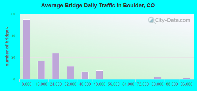
- 1,968,611Total average daily traffic
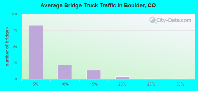
- 80,310Total average daily truck traffic
- National Bridge Inventory (NBI) Registered Bridges for Boulder
- No street view available for this location
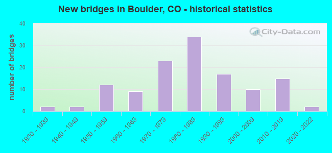
- New bridges - historical statistics
- 21930-1939
- 21940-1949
- 121950-1959
- 91960-1969
- 231970-1979
- 341980-1989
- 171990-1999
- 102000-2009
- 152010-2019
- 22020-2022
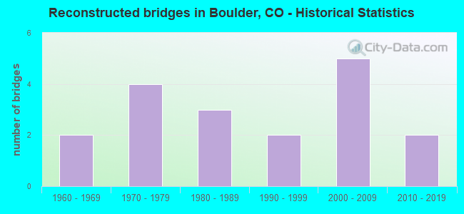
- Reconstructed bridges - Historical Statistics
- 21960-1969
- 41970-1979
- 31980-1989
- 21990-1999
- 52000-2009
- 22010-2019
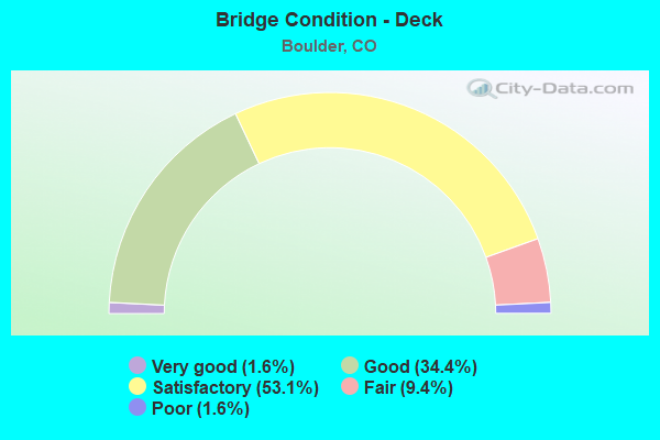
- Bridge Condition - Deck
- 1.6%Very good
- 34.4%Good
- 53.1%Satisfactory
- 9.4%Fair
- 1.6%Poor
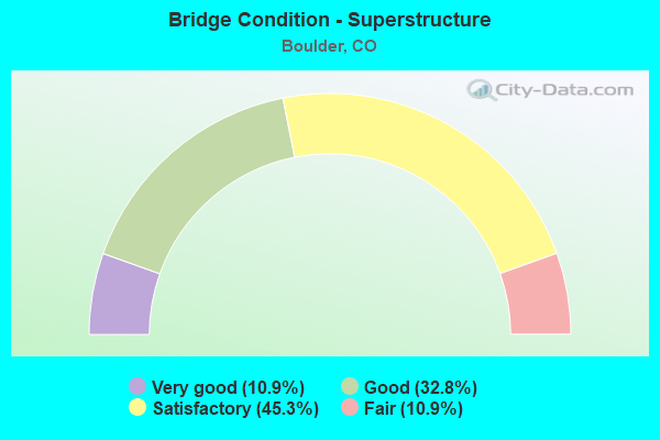
- Bridge Condition - Superstructure
- 10.9%Very good
- 32.8%Good
- 45.3%Satisfactory
- 10.9%Fair
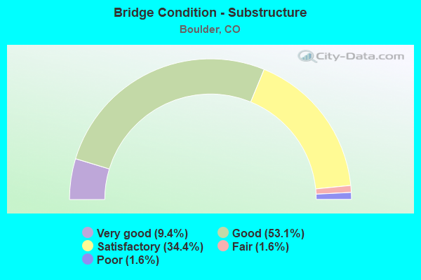
- Bridge Condition - Substructure
- 9.4%Very good
- 53.1%Good
- 34.4%Satisfactory
- 1.6%Fair
- 1.6%Poor
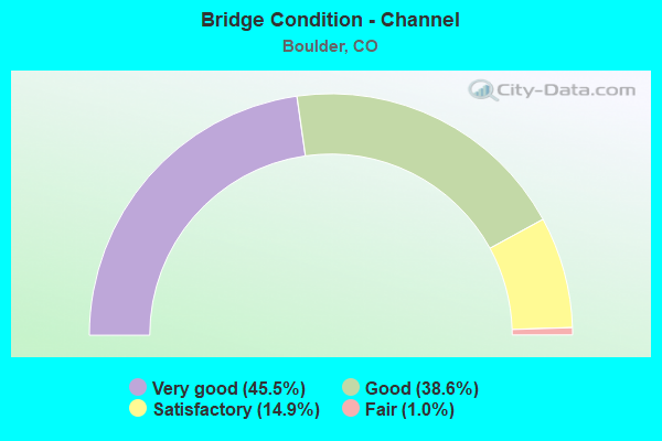
- Bridge Condition - Channel
- 45.5%Very good
- 38.6%Good
- 14.9%Satisfactory
- 1.0%Fair
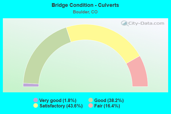
- Bridge Condition - Culverts
- 1.8%Very good
- 38.2%Good
- 43.6%Satisfactory
- 16.4%Fair
Find on map >> Show street view
Structure Number: BOLD-16-0.08-1A, Location: 0.08 Mi E of S. Broadway (Lat: 40.014214, Lng: -105.277697), Route carried "on" structure: City street , Year Built: 1988, Status: Open, Structure Length: 2.71m (8.89ft), Average Daily Traffic: 15,153 (year 2021), Truck Traffic: 2%, Average Future Daily Traffic: 18,184 (year 2041), Design Load: HS 20, Features Intersected: Boulder Creek, Facility Carried by Structure: Arapahoe Avenue
Minimum Vertical Clearance: 30+ m (98+ ft), Kilometerpoint: 1.780, Lanes on structure: 4, Owner: City or Municipal Highway Agency, Approaching Roadway Width: 14.0m (45.9ft), Skew: 4 degrees, Material/Design: Prestressed concrete, Design/Construction: Box Beam or Girders - Multiple, Number Of Spans In Main Unit: 1, Length of Maximum Span: 25.6m (84.0ft), Curb or Sidewalk Widths: Left: 1.8m (5.9ft), Right: 1.8m (5.9ft), Curb-To-Curb Width: 14.0m (45.9ft), Out-to-Out Width: 18.5m (60.7ft)
Condition: Deck: Good, Superstructure: Satisfactory, Substructure: Good, Channel: Very good, Operating Rating: 69.5 metric tons, Method Used To Determine Operating Rating: Load Factor (LF), Inventory Rating: 45.3 metric tons, Method Used To Determine Inventory Rating: Load Factor (LF), Structural Evaluation: Equal to present minimum criteria, Deck Geometry: High priority of replacement, Waterway Adequacy: Equal to present desirable criteria, Approach Roadway Alignment: Equal to present desirable criteria, Length Of Structure Improvement: 0.52m (1.71ft), Designated Inspection Frequency: Every 24 months, Inspection Date: Febuary 2021, Bridge Improvement Cost: $564,000, Roadway Improvement Cost: $56,000, Total Project Cost: $620,000 ( Estimate for 2019), Deck Structure Type: Other, Wearing Surface/Protective System: Wearing Surface: Bituminous
Find on map >> Show street view
Structure Number: BOLD-16-1.3-02A, Location: 50 Ft S of Canyon Blvd (Lat: 40.013042, Lng: -105.297906), Route carried "on" structure: City street , Year Built: 1990, Status: Open, Structure Length: 2.84m (9.32ft), Average Daily Traffic: 617 (year 2021), Truck Traffic: 14%, Average Future Daily Traffic: 740 (year 2041), Design Load: HS 20, Features Intersected: Boulder Creek, Facility Carried by Structure: Arapahoe Avenue
Minimum Vertical Clearance: 30+ m (98+ ft), Kilometerpoint: 0.039, Lanes on structure: 2, Owner: City or Municipal Highway Agency, Approaching Roadway Width: 7.3m (24.0ft), Material/Design: Prestressed concrete, Design/Construction: Box Beam or Girders - Multiple, Number Of Spans In Main Unit: 1, Length of Maximum Span: 27.4m (89.9ft), Curb or Sidewalk Widths: Left: 0.0m, Right: 1.5m (4.9ft), Curb-To-Curb Width: 7.3m (24.0ft), Out-to-Out Width: 9.8m (32.2ft)
Condition: Deck: Satisfactory, Superstructure: Very good, Substructure: Good, Channel: Very good, Operating Rating: 63.3 metric tons, Method Used To Determine Operating Rating: Load Factor (LF), Inventory Rating: 38.0 metric tons, Method Used To Determine Inventory Rating: Load Factor (LF), Structural Evaluation: Better than present minimum criteria, Deck Geometry: Meets minimum limits, Waterway Adequacy: Equal to present desirable criteria, Approach Roadway Alignment: Somewhat better than minimum adequacy, Designated Inspection Frequency: Every 24 months, Inspection Date: Febuary 2021, Deck Structure Type: Concrete Cast-file-Place, Wearing Surface/Protective System: Wearing Surface: Monolithic Concrete, Deck Protection: Epoxy Coated Reinforcing
Find on map >> Show street view
Structure Number: BOLD-17-0.28-1A, Location: 0.28 Mi E of Spine Road (Lat: 40.072700, Lng: -105.197078), Route carried "on" structure: City street , Year Built: 1996, Status: Open, Structure Length: 0.62m (2.03ft), Average Daily Traffic: 14,389 (year 2021), Truck Traffic: 4%, Average Future Daily Traffic: 17,267 (year 2041), Design Load: HS 20, Features Intersected: Boulder Cr. Supply Ditch, Facility Carried by Structure: Lookout Road
Minimum Vertical Clearance: 30+ m (98+ ft), Kilometerpoint: 1.015, Lanes on structure: 2, Owner: City or Municipal Highway Agency, Approaching Roadway Width: 11.0m (36.1ft), Skew: 3 degrees, Material/Design: Concrete, Design/Construction: Culvert, Number Of Spans In Main Unit: 1, Length of Maximum Span: 6.2m (20.3ft), Curb or Sidewalk Widths: Left: 0.0m, Right: 3.0m (9.8ft), Curb-To-Curb Width: 11.0m (36.1ft), Out-to-Out Width: 18.3m (60.0ft)
Condition: Channel: Very good, Culverts: Good, Structural Evaluation: Better than present minimum criteria, Deck Geometry: Meets minimum limits, Waterway Adequacy: Equal to present desirable criteria, Approach Roadway Alignment: Equal to present desirable criteria, Designated Inspection Frequency: Every 24 months, Inspection Date: January 2021
Find on map >> Show street view
Structure Number: BOLD-17-0.32-2A, Location: 0.32 Mi Eof Spine Street (Lat: 40.072697, Lng: -105.196261), Route carried "on" structure: City street , Year Built: 1996, Status: Open, Structure Length: 0.63m (2.07ft), Average Daily Traffic: 14,389 (year 2021), Truck Traffic: 4%, Average Future Daily Traffic: 17,267 (year 2041), Design Load: HS 20, Features Intersected: Whiterock Ditch, Facility Carried by Structure: Lookout Road
Minimum Vertical Clearance: 30+ m (98+ ft), Kilometerpoint: 1.073, Lanes on structure: 2, Owner: City or Municipal Highway Agency, Approaching Roadway Width: 11.0m (36.1ft), Skew: 4 degrees, Material/Design: Concrete, Design/Construction: Culvert, Number Of Spans In Main Unit: 1, Length of Maximum Span: 6.3m (20.7ft), Curb or Sidewalk Widths: Left: 3.0m (9.8ft), Right: 3.2m (10.5ft), Curb-To-Curb Width: 11.0m (36.1ft), Out-to-Out Width: 23.9m (78.4ft)
Condition: Channel: Good, Culverts: Good, Structural Evaluation: Better than present minimum criteria, Deck Geometry: Meets minimum limits, Waterway Adequacy: Equal to present desirable criteria, Approach Roadway Alignment: Equal to present desirable criteria, Designated Inspection Frequency: Every 24 months, Inspection Date: January 2021
Find on map >> Show street view
Structure Number: BOLD-18-0.1-01, Location: 0.2 Mi N of Valmont Drive (Lat: 40.031381, Lng: -105.239522), Route carried "on" structure: City street , Year Built: 1988, Status: Open, Structure Length: 2.68m (8.79ft), Average Daily Traffic: 1,678 (year 2021), Truck Traffic: 12%, Average Future Daily Traffic: 2,014 (year 2041), Design Load: HS 20, Features Intersected: Wonderland Creek, Facility Carried by Structure: Kingsridge Blvd.
Minimum Vertical Clearance: 30+ m (98+ ft), Kilometerpoint: 0.552, Lanes on structure: 2, Owner: City or Municipal Highway Agency, Approaching Roadway Width: 7.9m (25.9ft), Skew: 1 degrees, Material/Design: Concrete, Design/Construction: Culvert, Number Of Spans In Main Unit: 7, Length of Maximum Span: 5.0m (16.4ft), Curb or Sidewalk Widths: Left: 1.3m (4.3ft), Right: 0.0m, Curb-To-Curb Width: 8.2m (26.9ft), Out-to-Out Width: 10.3m (33.8ft)
Condition: Channel: Good, Culverts: Satisfactory, Operating Rating: 32.7 metric tons, Method Used To Determine Operating Rating: Field evaluation and documented engineering judgment, Inventory Rating: 32.7 metric tons, Method Used To Determine Inventory Rating: Field evaluation and documented engineering judgment, Structural Evaluation: Equal to present minimum criteria, Deck Geometry: Meets minimum limits, Waterway Adequacy: Equal to present desirable criteria, Approach Roadway Alignment: Equal to present desirable criteria, Designated Inspection Frequency: Every 24 months, Inspection Date: Febuary 2021
Find on map >> Show street view
Structure Number: BOLD-18-1.83-01, Location: At 49th Street (Lat: 40.021814, Lng: -105.238125), Route carried "on" structure: City street , Year Built: 1986, Status: Open, Structure Length: 2.29m (7.51ft), Average Daily Traffic: 12,291 (year 2021), Truck Traffic: 8%, Average Future Daily Traffic: 14,749 (year 2041), Design Load: HS 20, Features Intersected: S. Goose Creek Drainage, Facility Carried by Structure: Pearl Parkway
Minimum Vertical Clearance: 30+ m (98+ ft), Kilometerpoint: 0.431, Lanes on structure: 4, Owner: City or Municipal Highway Agency, Approaching Roadway Width: 20.8m (68.2ft), Skew: 36 degrees, Material/Design: Concrete, Design/Construction: Culvert, Number Of Spans In Main Unit: 3, Length of Maximum Span: 8.5m (27.9ft), Curb or Sidewalk Widths: Left: 1.9m (6.2ft), Right: 1.7m (5.6ft), Curb-To-Curb Width: 20.8m (68.2ft), Out-to-Out Width: 38.6m (126.6ft)
Condition: Channel: Good, Culverts: Fair, Operating Rating: 36.3 metric tons, Method Used To Determine Operating Rating: Field evaluation and documented engineering judgment, Inventory Rating: 32.7 metric tons, Method Used To Determine Inventory Rating: Field evaluation and documented engineering judgment, Structural Evaluation: Somewhat better than minimum adequacy, Deck Geometry: Superior to present desirable criteria, Waterway Adequacy: Better than present minimum criteria, Approach Roadway Alignment: Equal to present desirable criteria, Designated Inspection Frequency: Every 24 months, Inspection Date: Febuary 2021
Find on map >> Show street view
Structure Number: BOLD-18-2.21-02, Location: 0.6 M E of Foothills Pkwy (Lat: 40.023497, Lng: -105.231692), Route carried "on" structure: City street , Year Built: 1986, Status: Open, Structure Length: 1.33m (4.36ft), Average Daily Traffic: 12,929 (year 2021), Truck Traffic: 8%, Average Future Daily Traffic: 15,515 (year 2041), Design Load: HS 20, Features Intersected: North Goose Creek, Facility Carried by Structure: Pearl Parkway
Minimum Vertical Clearance: 30+ m (98+ ft), Kilometerpoint: 0.990, Lanes on structure: 2, Owner: City or Municipal Highway Agency, Approaching Roadway Width: 10.9m (35.8ft), Material/Design: Concrete, Design/Construction: Culvert, Number Of Spans In Main Unit: 3, Length of Maximum Span: 4.3m (14.1ft), Curb or Sidewalk Widths: Left: 0.0m, Right: 1.5m (4.9ft), Out-to-Out Width: 31.8m (104.3ft)
Condition: Channel: Good, Culverts: Satisfactory, Operating Rating: 70.9 metric tons, Method Used To Determine Operating Rating: Load Factor (LF), Inventory Rating: 42.5 metric tons, Method Used To Determine Inventory Rating: Load Factor (LF), Structural Evaluation: Equal to present minimum criteria, Waterway Adequacy: Equal to present desirable criteria, Approach Roadway Alignment: Equal to present desirable criteria, Designated Inspection Frequency: Every 24 months, Inspection Date: Febuary 2021
Find on map >> Show street view
Structure Number: BOLD-19-0.01-01, Location: 40 Ft N of Pearl Parkway (Lat: 40.022953, Lng: -105.242375), Route carried "on" structure: City street , Year Built: 1986, Status: Open, Structure Length: 1.31m (4.30ft), Average Daily Traffic: 4,808 (year 2021), Truck Traffic: 9%, Average Future Daily Traffic: 5,770 (year 2041), Design Load: HS 20, Features Intersected: South Goose Creek, Facility Carried by Structure: 47th Street
Minimum Vertical Clearance: 30+ m (98+ ft), Kilometerpoint: 0.022, Lanes on structure: 2, Owner: City or Municipal Highway Agency, Approaching Roadway Width: 12.2m (40.0ft), Skew: 2 degrees, Material/Design: Concrete, Design/Construction: Culvert, Number Of Spans In Main Unit: 4, Length of Maximum Span: 2.9m (9.5ft), Curb or Sidewalk Widths: Left: 0.0m, Right: 2.1m (6.9ft), Curb-To-Curb Width: 12.2m (40.0ft), Out-to-Out Width: 16.2m (53.1ft)
Condition: Channel: Good, Culverts: Satisfactory, Operating Rating: 36.3 metric tons, Method Used To Determine Operating Rating: Field evaluation and documented engineering judgment, Inventory Rating: 32.7 metric tons, Method Used To Determine Inventory Rating: Field evaluation and documented engineering judgment, Structural Evaluation: Equal to present minimum criteria, Deck Geometry: Equal to present minimum criteria, Waterway Adequacy: Equal to present desirable criteria, Approach Roadway Alignment: Equal to present desirable criteria, Designated Inspection Frequency: Every 24 months, Inspection Date: Febuary 2021, Deck Structure Type: Concrete Cast-file-Place, Wearing Surface/Protective System: Wearing Surface: Bituminous
Find on map >> Show street view
Structure Number: BOLD-20-0.01-01, Location: 30 Ft N of Pearl Parkway (Lat: 40.022381, Lng: -105.240747), Route carried "on" structure: City street , Year Built: 1986, Status: Open, Structure Length: 1.33m (4.36ft), Average Daily Traffic: 647 (year 2021), Truck Traffic: 11%, Average Future Daily Traffic: 776 (year 2041), Design Load: HS 20, Features Intersected: S. Goose Creek, Facility Carried by Structure: 48th CT
Minimum Vertical Clearance: 30+ m (98+ ft), Kilometerpoint: 0.175, Lanes on structure: 2, Owner: City or Municipal Highway Agency, Approaching Roadway Width: 9.8m (32.2ft), Material/Design: Concrete, Design/Construction: Culvert, Number Of Spans In Main Unit: 3, Length of Maximum Span: 4.9m (16.1ft), Curb or Sidewalk Widths: Left: 1.8m (5.9ft), Right: 1.8m (5.9ft), Curb-To-Curb Width: 11.0m (36.1ft), Out-to-Out Width: 15.2m (49.9ft)
Condition: Channel: Very good, Culverts: Good, Operating Rating: 36.3 metric tons, Method Used To Determine Operating Rating: Field evaluation and documented engineering judgment, Inventory Rating: 32.7 metric tons, Method Used To Determine Inventory Rating: Field evaluation and documented engineering judgment, Structural Evaluation: Better than present minimum criteria, Deck Geometry: Better than present minimum criteria, Waterway Adequacy: Equal to present desirable criteria, Approach Roadway Alignment: Equal to present desirable criteria, Designated Inspection Frequency: Every 48 months, Inspection Date: Febuary 2019, Deck Structure Type: Concrete Cast-file-Place, Wearing Surface/Protective System: Wearing Surface: Bituminous
Find on map >> Show street view
Structure Number: BOLD-21-1.20-01, Location: 0.25 Mi No of Baseline Rd (Lat: 40.004581, Lng: -105.239694), Route carried "on" structure: City street , Year Built: 1996, Status: Open, Structure Length: 0.64m (2.10ft), Average Daily Traffic: 1,508 (year 2021), Truck Traffic: 3%, Average Future Daily Traffic: 1,810 (year 2041), Design Load: HS 20, Features Intersected: Bear Crk and Bike Path, Facility Carried by Structure: Mohawk Drive
Minimum Vertical Clearance: 30+ m (98+ ft), Kilometerpoint: 2.411, Lanes on structure: 2, Owner: City or Municipal Highway Agency, Approaching Roadway Width: 12.8m (42.0ft), Skew: 2 degrees, Material/Design: Concrete, Design/Construction: Culvert, Number Of Spans In Main Unit: 1, Length of Maximum Span: 6.4m (21.0ft), Curb or Sidewalk Widths: Left: 1.4m (4.6ft), Right: 2.4m (7.9ft), Curb-To-Curb Width: 13.5m (44.3ft), Out-to-Out Width: 17.8m (58.4ft)
Condition: Channel: Very good, Culverts: Good, Operating Rating: 36.3 metric tons, Method Used To Determine Operating Rating: Field evaluation and documented engineering judgment, Inventory Rating: 32.7 metric tons, Method Used To Determine Inventory Rating: Field evaluation and documented engineering judgment, Structural Evaluation: Better than present minimum criteria, Deck Geometry: Superior to present desirable criteria, Waterway Adequacy: Equal to present desirable criteria, Approach Roadway Alignment: Equal to present desirable criteria, Designated Inspection Frequency: Every 24 months, Inspection Date: Febuary 2021, Deck Structure Type: Concrete Cast-file-Place, Wearing Surface/Protective System: Wearing Surface: Bituminous, Deck Protection: Epoxy Coated Reinforcing
Find on map >> Show street view
Structure Number: BOLD-22-0.44-01, Location: 300 Ft. E of 36th St. (Lat: 39.991608, Lng: -105.250058), Route carried "on" structure: City street , Year Built: 1995, Status: Open, Structure Length: 1.00m (3.28ft), Average Daily Traffic: 938 (year 2020), Truck Traffic: 6%, Average Future Daily Traffic: 1,126 (year 2040), Design Load: HS 20, Features Intersected: Bear Crk and Bike Path, Facility Carried by Structure: Martin Drive
Minimum Vertical Clearance: 30+ m (98+ ft), Kilometerpoint: 1.024, Lanes on structure: 2, Owner: City or Municipal Highway Agency, Approaching Roadway Width: 9.8m (32.2ft), Material/Design: Concrete, Design/Construction: Culvert, Number Of Spans In Main Unit: 2, Length of Maximum Span: 7.3m (24.0ft), Curb or Sidewalk Widths: Left: 1.9m (6.2ft), Right: 1.8m (5.9ft), Curb-To-Curb Width: 9.8m (32.2ft), Out-to-Out Width: 14.9m (48.9ft)
Condition: Channel: Very good, Culverts: Fair, Operating Rating: 36.3 metric tons, Method Used To Determine Operating Rating: Field evaluation and documented engineering judgment, Inventory Rating: 32.7 metric tons, Method Used To Determine Inventory Rating: Field evaluation and documented engineering judgment, Structural Evaluation: Somewhat better than minimum adequacy, Deck Geometry: Equal to present minimum criteria, Waterway Adequacy: Equal to present desirable criteria, Approach Roadway Alignment: Equal to present desirable criteria, Designated Inspection Frequency: Every 24 months, Inspection Date: Febuary 2021
Find on map >> Show street view
Structure Number: BOLD-33-STERDR, Location: 100 Ft E of 47th Street (Lat: 40.027253, Lng: -105.243794), Route carried "on" structure: City street , Year Built: 1975, Status: Open, Structure Length: 0.61m (2.00ft), Average Daily Traffic: 1,558 (year 2021), Truck Traffic: 13%, Average Future Daily Traffic: 1,870 (year 2041), Design Load: HS 20, Features Intersected: Left Hand Ditch, Facility Carried by Structure: Sterling Drive
Minimum Vertical Clearance: 30+ m (98+ ft), Kilometerpoint: 0.039, Lanes on structure: 2, Owner: City or Municipal Highway Agency, Approaching Roadway Width: 12.2m (40.0ft), Skew: 3 degrees, Material/Design: Concrete, Design/Construction: Culvert, Number Of Spans In Main Unit: 2, Length of Maximum Span: 2.9m (9.5ft), Curb or Sidewalk Widths: Left: 2.1m (6.9ft), Right: 2.1m (6.9ft), Out-to-Out Width: 16.7m (54.8ft)
Condition: Channel: Satisfactory, Culverts: Satisfactory, Operating Rating: 36.3 metric tons, Method Used To Determine Operating Rating: Field evaluation and documented engineering judgment, Inventory Rating: 32.7 metric tons, Method Used To Determine Inventory Rating: Field evaluation and documented engineering judgment, Structural Evaluation: Equal to present minimum criteria, Waterway Adequacy: Equal to present minimum criteria, Approach Roadway Alignment: Equal to present desirable criteria, Designated Inspection Frequency: Every 24 months, Inspection Date: Febuary 2021
Find on map >> Show street view
Structure Number: BOLD-34-PEARLPW, Location: 500 Ft W of Foothills Pky (Lat: 40.023244, Lng: -105.249753), Route carried "on" structure: City street , Year Built: 1981, Status: Open, Structure Length: 1.04m (3.41ft), Average Daily Traffic: 22,050 (year 2021), Truck Traffic: 9%, Average Future Daily Traffic: 26,460 (year 2041), Design Load: HS 20, Features Intersected: Left Hand Ditch, Facility Carried by Structure: Pearl Parkway
Minimum Vertical Clearance: 30+ m (98+ ft), Kilometerpoint: 2.345, Lanes on structure: 2, Owner: City or Municipal Highway Agency, Approaching Roadway Width: 16.6m (54.5ft), Skew: 32 degrees, Material/Design: Concrete, Design/Construction: Culvert, Number Of Spans In Main Unit: 3, Length of Maximum Span: 3.9m (12.8ft), Curb or Sidewalk Widths: Left: 0.0m, Right: 4.1m (13.5ft), Out-to-Out Width: 30.9m (101.4ft)
Condition: Channel: Good, Culverts: Satisfactory, Operating Rating: 36.3 metric tons, Method Used To Determine Operating Rating: Field evaluation and documented engineering judgment, Inventory Rating: 32.7 metric tons, Method Used To Determine Inventory Rating: Field evaluation and documented engineering judgment, Structural Evaluation: Equal to present minimum criteria, Waterway Adequacy: Equal to present desirable criteria, Approach Roadway Alignment: Equal to present desirable criteria, Designated Inspection Frequency: Every 24 months, Inspection Date: Febuary 2021
Find on map >> Show street view
Structure Number: BOLD-35-AURORAA, Location: 15 Ft. W of 6th Street (Lat: 40.003639, Lng: -105.286892), Route carried "on" structure: City street , Year Built: 1980, Status: Open, Structure Length: 0.62m (2.03ft), Average Daily Traffic: 296 (year 2021), Truck Traffic: 5%, Average Future Daily Traffic: 355 (year 2041), Features Intersected: Gregory Creek, Facility Carried by Structure: Aurora Avenue
Minimum Vertical Clearance: 30+ m (98+ ft), Kilometerpoint: 0.201, Lanes on structure: 2, Owner: City or Municipal Highway Agency, Approaching Roadway Width: 9.1m (29.9ft), Material/Design: Concrete, Design/Construction: Culvert, Number Of Spans In Main Unit: 2, Length of Maximum Span: 3.0m (9.8ft), Curb or Sidewalk Widths: Left: 1.3m (4.3ft), Right: 1.3m (4.3ft), Curb-To-Curb Width: 9.8m (32.2ft), Out-to-Out Width: 14.6m (47.9ft)
Condition: Channel: Good, Culverts: Good, Operating Rating: 36.3 metric tons, Method Used To Determine Operating Rating: Field evaluation and documented engineering judgment, Inventory Rating: 32.7 metric tons, Method Used To Determine Inventory Rating: Field evaluation and documented engineering judgment, Structural Evaluation: Better than present minimum criteria, Deck Geometry: Better than present minimum criteria, Waterway Adequacy: Equal to present desirable criteria, Approach Roadway Alignment: Equal to present desirable criteria, Designated Inspection Frequency: Every 24 months, Inspection Date: January 2021
Find on map >> Show street view
Structure Number: BOLD-36-TABMSAD, Location: Harvard Ln & SB Table (Lat: 39.985028, Lng: -105.250722), Route carried "on" structure: City street , Year Built: 1980, Status: Open, Structure Length: 0.75m (2.46ft), Average Daily Traffic: 8,569 (year 2021), Truck Traffic: 3%, Average Future Daily Traffic: 10,283 (year 2041), Features Intersected: Bear Creek, Facility Carried by Structure: SB Table Mesa Dr.
Minimum Vertical Clearance: 30+ m (98+ ft), Kilometerpoint: 4.345, Lanes on structure: 2, Owner: City or Municipal Highway Agency, Approaching Roadway Width: 9.8m (32.2ft), Skew: 4 degrees, Material/Design: Concrete, Design/Construction: Culvert, Number Of Spans In Main Unit: 2, Length of Maximum Span: 3.6m (11.8ft), Curb or Sidewalk Widths: Left: 3.0m (9.8ft), Right: 1.4m (4.6ft), Curb-To-Curb Width: 23.9m (78.4ft), Out-to-Out Width: 24.5m (80.4ft)
Condition: Channel: Good, Culverts: Fair, Operating Rating: 36.3 metric tons, Method Used To Determine Operating Rating: Field evaluation and documented engineering judgment, Inventory Rating: 32.7 metric tons, Method Used To Determine Inventory Rating: Field evaluation and documented engineering judgment, Structural Evaluation: Somewhat better than minimum adequacy, Deck Geometry: Superior to present desirable criteria, Waterway Adequacy: Equal to present desirable criteria, Approach Roadway Alignment: Equal to present desirable criteria, Designated Inspection Frequency: Every 24 months, Inspection Date: Febuary 2021
Find on map >> Show street view
Structure Number: BOLD-37-COLOAVE, Location: At 38th Street (Lat: 40.007261, Lng: -105.245069), Route carried "on" structure: City street , Year Built: 1979, Status: Open, Structure Length: 0.94m (3.08ft), Average Daily Traffic: 6,977 (year 2021), Truck Traffic: 6%, Average Future Daily Traffic: 8,372 (year 2041), Features Intersected: Skunk Creek, Facility Carried by Structure: Colorado Avenue
Minimum Vertical Clearance: 30+ m (98+ ft), Kilometerpoint: 1.640, Lanes on structure: 4, Owner: City or Municipal Highway Agency, Approaching Roadway Width: 20.9m (68.6ft), Skew: 4 degrees, Material/Design: Concrete, Design/Construction: Culvert, Number Of Spans In Main Unit: 2, Length of Maximum Span: 4.5m (14.8ft), Curb or Sidewalk Widths: Left: 3.3m (10.8ft), Right: 2.4m (7.9ft), Curb-To-Curb Width: 31.9m (104.7ft), Out-to-Out Width: 32.6m (107.0ft)
Condition: Channel: Good, Culverts: Satisfactory, Operating Rating: 36.3 metric tons, Method Used To Determine Operating Rating: Field evaluation and documented engineering judgment, Inventory Rating: 32.7 metric tons, Method Used To Determine Inventory Rating: Field evaluation and documented engineering judgment, Structural Evaluation: Equal to present minimum criteria, Deck Geometry: Superior to present desirable criteria, Waterway Adequacy: Equal to present desirable criteria, Approach Roadway Alignment: Equal to present desirable criteria, Designated Inspection Frequency: Every 24 months, Inspection Date: Febuary 2021
Find on map >> Show street view
Structure Number: BOLD-38-GLENWDR, Location: 400 Ft W of State Hwy 36 (Lat: 40.032728, Lng: -105.260328), Route carried "on" structure: City street , Year Built: 1972, Status: Open, Structure Length: 0.78m (2.56ft), Average Daily Traffic: 5,213 (year 2021), Truck Traffic: 4%, Average Future Daily Traffic: 6,256 (year 2041), Design Load: HS 20, Features Intersected: Two Mile Creek, Facility Carried by Structure: Glenwood Drive
Minimum Vertical Clearance: 30+ m (98+ ft), Kilometerpoint: 0.240, Lanes on structure: 2, Owner: City or Municipal Highway Agency, Approaching Roadway Width: 12.2m (40.0ft), Skew: 3 degrees, Material/Design: Concrete, Design/Construction: Culvert, Number Of Spans In Main Unit: 2, Length of Maximum Span: 3.7m (12.1ft), Curb or Sidewalk Widths: Left: 1.2m (3.9ft), Right: 1.2m (3.9ft), Curb-To-Curb Width: 20.2m (66.3ft), Out-to-Out Width: 20.6m (67.6ft)
Condition: Channel: Good, Culverts: Satisfactory, Operating Rating: 36.3 metric tons, Method Used To Determine Operating Rating: Field evaluation and documented engineering judgment, Inventory Rating: 32.7 metric tons, Method Used To Determine Inventory Rating: Field evaluation and documented engineering judgment, Structural Evaluation: Equal to present minimum criteria, Deck Geometry: Superior to present desirable criteria, Waterway Adequacy: Equal to present desirable criteria, Approach Roadway Alignment: Equal to present desirable criteria, Designated Inspection Frequency: Every 24 months, Inspection Date: Febuary 2021
Find on map >> Show street view
Structure Number: BOLD-39-27THST, Location: 50 ft N of Mapleton Ave (Lat: 40.027558, Lng: -105.261889), Route carried "on" structure: City street , Year Built: 2001, Status: Open, Structure Length: 2.08m (6.82ft), Average Daily Traffic: 147 (year 2021), Truck Traffic: 3%, Average Future Daily Traffic: 176 (year 2041), Design Load: HS 20, Features Intersected: Goose Creek, Facility Carried by Structure: 27th Street
Minimum Vertical Clearance: 30+ m (98+ ft), Kilometerpoint: 0.000, Lanes on structure: 2, Owner: City or Municipal Highway Agency, Approaching Roadway Width: 9.1m (29.9ft), Material/Design: Prestressed concrete, Design/Construction: Box Beam or Girders - Single/Spread, Number Of Spans In Main Unit: 1, Length of Maximum Span: 19.3m (63.3ft), Curb or Sidewalk Widths: Left: 1.2m (3.9ft), Right: 1.3m (4.3ft), Curb-To-Curb Width: 7.6m (24.9ft), Out-to-Out Width: 11.0m (36.1ft)
Condition: Deck: Good, Superstructure: Very good, Substructure: Good, Channel: Very good, Operating Rating: 36.3 metric tons, Method Used To Determine Operating Rating: Field evaluation and documented engineering judgment, Inventory Rating: 32.7 metric tons, Method Used To Determine Inventory Rating: Field evaluation and documented engineering judgment, Structural Evaluation: Better than present minimum criteria, Deck Geometry: Somewhat better than minimum adequacy, Waterway Adequacy: Equal to present desirable criteria, Approach Roadway Alignment: Equal to present desirable criteria, Designated Inspection Frequency: Every 24 months, Inspection Date: Febuary 2021, Deck Structure Type: Concrete Cast-file-Place, Wearing Surface/Protective System: Wearing Surface: Bituminous, Deck Protection: Epoxy Coated Reinforcing
Find on map >> Show street view
Structure Number: BOLD-39-N63RD-A, Location: 0.4 MI N of SH7 (Lat: 40.019875, Lng: -105.206631), Route carried "on" structure: City street , Year Built: 2015, Status: Open, Structure Length: 1.39m (4.56ft), Average Daily Traffic: 4,334 (year 2021), Truck Traffic: 25%, Average Future Daily Traffic: 5,201 (year 2041), Design Load: HL 93, Features Intersected: Leggett Ditch, Facility Carried by Structure: N. 63rd St (CR39)
Minimum Vertical Clearance: 30+ m (98+ ft), Kilometerpoint: 0.583, Lanes on structure: 2, Owner: City or Municipal Highway Agency, Approaching Roadway Width: 9.8m (32.2ft), Skew: 1 degrees, Material/Design: Concrete, Design/Construction: Culvert, Number Of Spans In Main Unit: 3, Length of Maximum Span: 4.5m (14.8ft), Curb or Sidewalk Widths: Left: 2.0m (6.6ft), Right: 0.0m, Curb-To-Curb Width: 10.5m (34.4ft), Out-to-Out Width: 13.5m (44.3ft)
Condition: Channel: Satisfactory, Culverts: Good, Operating Rating: 61.9 metric tons, Method Used To Determine Operating Rating: Load and Resistance Factor Rating (LRFR) rating reported by rating factor(RF) method using HL-93 loadings, Inventory Rating: 48.0 metric tons, Method Used To Determine Inventory Rating: Load and Resistance Factor Rating (LRFR) rating reported by rating factor(RF) method using HL-93 loadings, Structural Evaluation: Better than present minimum criteria, Deck Geometry: Somewhat better than minimum adequacy, Waterway Adequacy: Equal to present desirable criteria, Approach Roadway Alignment: Equal to present desirable criteria, Designated Inspection Frequency: Every 24 months, Underwater Inspection Frequency: Every 60 months, Inspection Date: Febuary 2021, Underwater Inspection Date: October 2020
Find on map >> Show street view
Structure Number: BOLD-40-IRISAVE, Location: 0.15 Mi W of US36/28th St (Lat: 40.036339, Lng: -105.261458), Route carried "on" structure: City street , Year Built: 2005, Status: Open, Structure Length: 0.61m (2.00ft), Average Daily Traffic: 27,466 (year 2021), Truck Traffic: 4%, Average Future Daily Traffic: 32,959 (year 2041), Design Load: HL 93, Features Intersected: Elmers Two Mile Ditch, Facility Carried by Structure: Iris Ave
Minimum Vertical Clearance: 30+ m (98+ ft), Kilometerpoint: 1.743, Lanes on structure: 4, Owner: City or Municipal Highway Agency, Approaching Roadway Width: 18.9m (62.0ft), Material/Design: Concrete, Design/Construction: Culvert, Number Of Spans In Main Unit: 1, Length of Maximum Span: 6.1m (20.0ft), Curb or Sidewalk Widths: Left: 1.5m (4.9ft), Right: 3.2m (10.5ft), Curb-To-Curb Width: 16.6m (54.5ft), Out-to-Out Width: 25.3m (83.0ft)
Condition: Channel: Very good, Culverts: Good, Operating Rating: 96.9 metric tons, Method Used To Determine Operating Rating: Load and Resistance Factor Rating (LRFR) rating reported by rating factor(RF) method using HL-93 loadings, Inventory Rating: 81.6 metric tons, Method Used To Determine Inventory Rating: Load and Resistance Factor Rating (LRFR) rating reported by rating factor(RF) method using HL-93 loadings, Structural Evaluation: Better than present minimum criteria, Deck Geometry: Somewhat better than minimum adequacy, Waterway Adequacy: Equal to present desirable criteria, Approach Roadway Alignment: Equal to present desirable criteria, Designated Inspection Frequency: Every 24 months, Inspection Date: Febuary 2021
Find on map >> Show street view
Structure Number: BOLD-41-IRISAVE, Location: Iris Ave and 34th St. (Lat: 40.036481, Lng: -105.248947), Route carried "on" structure: City street , Year Built: 2017, Status: Open, Structure Length: 1.47m (4.82ft), Average Daily Traffic: 2,874 (year 2021), Truck Traffic: 4%, Average Future Daily Traffic: 3,449 (year 2041), Design Load: HL 93, Features Intersected: Wonderland Creek, Facility Carried by Structure: Iris Avenue/34 St
Minimum Vertical Clearance: 30+ m (98+ ft), Kilometerpoint: 0.610, Lanes on structure: 2, Owner: City or Municipal Highway Agency, Approaching Roadway Width: 9.1m (29.9ft), Skew: 5 degrees, Material/Design: Concrete, Design/Construction: Culvert, Number Of Spans In Main Unit: 2, Length of Maximum Span: 7.1m (23.3ft), Curb or Sidewalk Widths: Left: 3.0m (9.8ft), Right: 1.5m (4.9ft), Curb-To-Curb Width: 9.1m (29.9ft), Out-to-Out Width: 16.3m (53.5ft)
Condition: Channel: Very good, Culverts: Good, Operating Rating: 47.0 metric tons, Method Used To Determine Operating Rating: Load and Resistance Factor Rating (LRFR) rating reported by rating factor(RF) method using HL-93 loadings, Inventory Rating: 36.3 metric tons, Method Used To Determine Inventory Rating: Load and Resistance Factor Rating (LRFR) rating reported by rating factor(RF) method using HL-93 loadings, Structural Evaluation: Better than present minimum criteria, Deck Geometry: Meets minimum limits, Waterway Adequacy: Equal to present desirable criteria, Approach Roadway Alignment: Equal to present desirable criteria, Designated Inspection Frequency: Every 24 months, Inspection Date: January 2021
Find on map >> Show street view
Structure Number: BOLD-42-JUNCTPL, Location: 0.1 mi N of Pearl Pkwy (Lat: 40.025183, Lng: -105.251114), Route carried "on" structure: City street , Year Built: 2017, Status: Open, Structure Length: 2.42m (7.94ft), Average Daily Traffic: 1,262 (year 2021), Truck Traffic: 4%, Average Future Daily Traffic: 1,514 (year 2041), Design Load: HL 93, Features Intersected: Goose Creek, Facility Carried by Structure: Junction Pl
Minimum Vertical Clearance: 30+ m (98+ ft), Kilometerpoint: 0.327, Lanes on structure: 2, Owner: City or Municipal Highway Agency, Approaching Roadway Width: 7.6m (24.9ft), Skew: 5 degrees, Material/Design: Prestressed concrete, Design/Construction: Box Beam or Girders - Single/Spread, Number Of Spans In Main Unit: 1, Length of Maximum Span: 21.7m (71.2ft), Curb or Sidewalk Widths: Left: 4.0m (13.1ft), Right: 4.0m (13.1ft), Curb-To-Curb Width: 7.3m (24.0ft), Out-to-Out Width: 16.6m (54.5ft)
Condition: Deck: Satisfactory, Superstructure: Good, Substructure: Good, Channel: Very good, Operating Rating: 36.3 metric tons, Method Used To Determine Operating Rating: Field evaluation and documented engineering judgment, Inventory Rating: 32.7 metric tons, Method Used To Determine Inventory Rating: Field evaluation and documented engineering judgment, Structural Evaluation: Better than present minimum criteria, Deck Geometry: Meets minimum limits, Waterway Adequacy: Equal to present desirable criteria, Approach Roadway Alignment: Equal to present desirable criteria, Designated Inspection Frequency: Every 24 months, Inspection Date: Febuary 2021, Deck Structure Type: Concrete Cast-file-Place, Wearing Surface/Protective System: Wearing Surface: Monolithic Concrete, Deck Protection: Epoxy Coated Reinforcing
Find on map >> Show street view
Structure Number: BOLD-43-SPRGCRK, Location: 570 ft from 34th St. (Lat: 40.035622, Lng: -105.246850), Route carried "on" structure: City street , Year Built: 2017, Status: Open, Structure Length: 2.26m (7.41ft), Average Daily Traffic: 100 (year 2017), Average Future Daily Traffic: 100 (year 2037), Features Intersected: Wonderland Creek, Facility Carried by Structure: Spring Creek Place
Minimum Vertical Clearance: 30+ m (98+ ft), Kilometerpoint: 0.161, Lanes on structure: 2, Owner: City or Municipal Highway Agency, Approaching Roadway Width: 9.1m (29.9ft), Skew: 4 degrees, Material/Design: Concrete, Design/Construction: Culvert, Number Of Spans In Main Unit: 5, Length of Maximum Span: 6.3m (20.7ft), Curb-To-Curb Width: 8.5m (27.9ft), Out-to-Out Width: 9.0m (29.5ft)
Condition: Channel: Very good, Culverts: Good, Operating Rating: 56.1 metric tons, Method Used To Determine Operating Rating: Load and Resistance Factor Rating (LRFR) rating reported by rating factor(RF) method using HL-93 loadings, Inventory Rating: 43.4 metric tons, Method Used To Determine Inventory Rating: Load and Resistance Factor Rating (LRFR) rating reported by rating factor(RF) method using HL-93 loadings, Structural Evaluation: Better than present minimum criteria, Deck Geometry: Better than present minimum criteria, Waterway Adequacy: Equal to present desirable criteria, Approach Roadway Alignment: Better than present minimum criteria, Designated Inspection Frequency: Every 24 months, Inspection Date: Febuary 2021
Find on map >> Show street view
Structure Number: BOLD-44-WNDGTRL, Location: 300 ft W of 28th (Lat: 40.043522, Lng: -105.259767), Route carried "on" structure: City street , Year Built: 2018, Status: Open, Structure Length: 1.55m (5.09ft), Average Daily Traffic: 920 (year 2021), Truck Traffic: 4%, Average Future Daily Traffic: 1,104 (year 2041), Features Intersected: Wonderland Creek, Facility Carried by Structure: Winding Trail Dr
Minimum Vertical Clearance: 30+ m (98+ ft), Kilometerpoint: 0.280, Lanes on structure: 2, Owner: City or Municipal Highway Agency, Approaching Roadway Width: 7.1m (23.3ft), Skew: 2 degrees, Material/Design: Concrete, Design/Construction: Culvert, Number Of Spans In Main Unit: 3, Length of Maximum Span: 5.0m (16.4ft), Curb or Sidewalk Widths: Left: 1.4m (4.6ft), Right: 3.8m (12.5ft), Curb-To-Curb Width: 7.1m (23.3ft), Out-to-Out Width: 18.9m (62.0ft)
Condition: Channel: Very good, Culverts: Satisfactory, Operating Rating: 48.9 metric tons, Method Used To Determine Operating Rating: Load and Resistance Factor Rating (LRFR) rating reported by rating factor(RF) method using HL-93 loadings, Inventory Rating: 37.6 metric tons, Method Used To Determine Inventory Rating: Load and Resistance Factor Rating (LRFR) rating reported by rating factor(RF) method using HL-93 loadings, Structural Evaluation: Equal to present minimum criteria, Deck Geometry: Meets minimum limits, Waterway Adequacy: Equal to present desirable criteria, Approach Roadway Alignment: Equal to present desirable criteria, Designated Inspection Frequency: Every 24 months, Inspection Date: January 2021, Deck Structure Type: Concrete Cast-file-Place, Wearing Surface/Protective System: Wearing Surface: Monolithic Concrete
Find on map >> Show street view
Structure Number: BOLD-46-34THST, Location: 40 ft S. of Iris Ave (Lat: 40.036303, Lng: -105.248944), Route carried "on" structure: City street , Year Built: 2018, Status: Open, Structure Length: 0.98m (3.22ft), Average Daily Traffic: 1,839 (year 2021), Truck Traffic: 3%, Average Future Daily Traffic: 2,207 (year 2041), Features Intersected: Wonderland Creek, Facility Carried by Structure: 34th Street
Minimum Vertical Clearance: 30+ m (98+ ft), Kilometerpoint: 0.344, Lanes on structure: 2, Owner: City or Municipal Highway Agency, Approaching Roadway Width: 11.0m (36.1ft), Skew: 1 degrees, Material/Design: Concrete, Design/Construction: Culvert, Number Of Spans In Main Unit: 2, Length of Maximum Span: 3.7m (12.1ft), Curb or Sidewalk Widths: Left: 1.2m (3.9ft), Right: 1.8m (5.9ft), Curb-To-Curb Width: 9.2m (30.2ft), Out-to-Out Width: 12.9m (42.3ft)
Condition: Channel: Very good, Culverts: Good, Operating Rating: 36.3 metric tons, Method Used To Determine Operating Rating: Field evaluation and documented engineering judgment, Inventory Rating: 32.7 metric tons, Method Used To Determine Inventory Rating: Field evaluation and documented engineering judgment, Structural Evaluation: Better than present minimum criteria, Deck Geometry: Somewhat better than minimum adequacy, Waterway Adequacy: Equal to present desirable criteria, Approach Roadway Alignment: Equal to present desirable criteria, Designated Inspection Frequency: Every 24 months, Inspection Date: January 2021
Find on map >> Show street view
Structure Number: BOLD-47-GLPNDR, Location: 350 ft S of Evans Dr (Lat: 40.000564, Lng: -105.243525), Route carried "on" structure: City street , Year Built: 1997, Status: Open, Structure Length: 0.62m (2.03ft), Average Daily Traffic: 425 (year 2020), Truck Traffic: 4%, Average Future Daily Traffic: 510 (year 2040), Features Intersected: Bear Canyon Creek, Facility Carried by Structure: Gilpin Drive
Minimum Vertical Clearance: 30+ m (98+ ft), Kilometerpoint: 0.378, Lanes on structure: 2, Owner: City or Municipal Highway Agency, Approaching Roadway Width: 8.5m (27.9ft), Material/Design: Concrete, Design/Construction: Culvert, Number Of Spans In Main Unit: 1, Length of Maximum Span: 6.2m (20.3ft), Curb or Sidewalk Widths: Left: 1.7m (5.6ft), Right: 2.6m (8.5ft), Curb-To-Curb Width: 8.2m (26.9ft), Out-to-Out Width: 13.4m (44.0ft)
Condition: Channel: Good, Culverts: Good, Operating Rating: 36.3 metric tons, Method Used To Determine Operating Rating: Field evaluation and documented engineering judgment, Inventory Rating: 32.7 metric tons, Method Used To Determine Inventory Rating: Field evaluation and documented engineering judgment, Structural Evaluation: Better than present minimum criteria, Deck Geometry: Somewhat better than minimum adequacy, Waterway Adequacy: Equal to present desirable criteria, Approach Roadway Alignment: Equal to present desirable criteria, Designated Inspection Frequency: Every 24 months, Inspection Date: Febuary 2021
Find on map >> Show street view
Structure Number: BOLD-48-VALMONT, Location: 400 ft W of 28th (Lat: 40.029039, Lng: -105.259847), Route carried "on" structure: City street , Year Built: 2010, Status: Open, Structure Length: 0.67m (2.20ft), Average Daily Traffic: 13,951 (year 2021), Truck Traffic: 4%, Average Future Daily Traffic: 16,741 (year 2041), Design Load: H 10, Features Intersected: Elmers Twomile Creek, Facility Carried by Structure: Valmont Road
Minimum Vertical Clearance: 30+ m (98+ ft), Kilometerpoint: 0.518, Lanes on structure: 4, Owner: City or Municipal Highway Agency, Approaching Roadway Width: 17.5m (57.4ft), Skew: 20 degrees, Material/Design: Concrete, Design/Construction: Culvert, Number Of Spans In Main Unit: 1, Length of Maximum Span: 6.7m (22.0ft), Curb or Sidewalk Widths: Left: 2.5m (8.2ft), Right: 2.2m (7.2ft), Curb-To-Curb Width: 17.5m (57.4ft), Out-to-Out Width: 29.2m (95.8ft)
Condition: Channel: Good, Culverts: Good, Operating Rating: 36.3 metric tons, Method Used To Determine Operating Rating: Field evaluation and documented engineering judgment, Inventory Rating: 32.7 metric tons, Method Used To Determine Inventory Rating: Field evaluation and documented engineering judgment, Structural Evaluation: Better than present minimum criteria, Deck Geometry: Somewhat better than minimum adequacy, Waterway Adequacy: Equal to present desirable criteria, Approach Roadway Alignment: Equal to present desirable criteria, Designated Inspection Frequency: Every 24 months, Inspection Date: Febuary 2021
Find on map >> Show street view
Structure Number: BOLD-49-48THST, Location: Just N. of Pearl St (Lat: 40.025486, Lng: -105.241761), Route carried "on" structure: City street , Year Built: 1980, Status: Open, Structure Length: 1.37m (4.49ft), Average Daily Traffic: 796 (year 2021), Truck Traffic: 7%, Average Future Daily Traffic: 955 (year 2041), Features Intersected: Goose Creek, Facility Carried by Structure: 48th Street
Minimum Vertical Clearance: 30+ m (98+ ft), Kilometerpoint: 0.201, Lanes on structure: 2, Owner: City or Municipal Highway Agency, Approaching Roadway Width: 7.3m (24.0ft), Material/Design: Concrete, Design/Construction: Culvert, Number Of Spans In Main Unit: 3, Length of Maximum Span: 4.6m (15.1ft), Curb-To-Curb Width: 9.8m (32.2ft), Out-to-Out Width: 10.4m (34.1ft)
Condition: Channel: Very good, Culverts: Good, Operating Rating: 36.3 metric tons, Method Used To Determine Operating Rating: Field evaluation and documented engineering judgment, Inventory Rating: 32.7 metric tons, Method Used To Determine Inventory Rating: Field evaluation and documented engineering judgment, Structural Evaluation: Better than present minimum criteria, Deck Geometry: Equal to present minimum criteria, Waterway Adequacy: Equal to present desirable criteria, Approach Roadway Alignment: Equal to present desirable criteria, Designated Inspection Frequency: Every 24 months, Inspection Date: Febuary 2021
Find on map >> Show street view
Structure Number: BOLD-50-BASELN, Location: 300 ft E of Meadow Dr (Lat: 39.999992, Lng: -105.245150), Route carried "on" structure: City street , Year Built: 1980, Status: Open, Structure Length: 1.23m (4.04ft), Average Daily Traffic: 20,271 (year 2021), Truck Traffic: 6%, Average Future Daily Traffic: 24,325 (year 2041), Features Intersected: Bear Canyon Creek, Facility Carried by Structure: Baseline Road
Minimum Vertical Clearance: 30+ m (98+ ft), Kilometerpoint: 1.098, Lanes on structure: 4, Owner: City or Municipal Highway Agency, Approaching Roadway Width: 23.8m (78.1ft), Skew: 35 degrees, Material/Design: Concrete, Design/Construction: Culvert, Number Of Spans In Main Unit: 2, Length of Maximum Span: 5.9m (19.4ft), Curb or Sidewalk Widths: Left: 0.9m (3.0ft), Right: 1.8m (5.9ft), Curb-To-Curb Width: 23.8m (78.1ft), Out-to-Out Width: 33.9m (111.2ft)
Condition: Channel: Good, Culverts: Satisfactory, Operating Rating: 36.3 metric tons, Method Used To Determine Operating Rating: Field evaluation and documented engineering judgment, Inventory Rating: 32.7 metric tons, Method Used To Determine Inventory Rating: Field evaluation and documented engineering judgment, Structural Evaluation: Equal to present minimum criteria, Deck Geometry: Superior to present desirable criteria, Waterway Adequacy: Equal to present desirable criteria, Approach Roadway Alignment: Equal to present desirable criteria, Designated Inspection Frequency: Every 24 months, Inspection Date: Febuary 2021
Find on map >> Show street view
Structure Number: BOLD-51-MONROE, Location: 0.1 Mi S of Colorado Ave. (Lat: 40.006889, Lng: -105.242972), Route carried "on" structure: City street , Year Built: 2020, Status: Open, Structure Length: 0.91m (2.99ft), Average Daily Traffic: 1,297 (year 2016), Truck Traffic: 2%, Average Future Daily Traffic: 3,256 (year 2036), Design Load: HS 20, Features Intersected: EMPSON DITCH, Facility Carried by Structure: MONROE DRIVE
Minimum Vertical Clearance: 30.48m (100.00ft), Kilometerpoint: 0.362, Lanes on structure: 2, Owner: City or Municipal Highway Agency, Approaching Roadway Width: 8.2m (26.9ft), Material/Design: Prestressed concrete, Design/Construction: Tee Beam, Number Of Spans In Main Unit: 1, Length of Maximum Span: 8.5m (27.9ft), Curb or Sidewalk Widths: Left: 0.9m (3.0ft), Right: 3.0m (9.8ft), Curb-To-Curb Width: 8.2m (26.9ft), Out-to-Out Width: 12.2m (40.0ft)
Condition: Deck: Satisfactory, Superstructure: Satisfactory, Substructure: Good, Channel: Good, Operating Rating: 36.3 metric tons, Method Used To Determine Operating Rating: Field evaluation and documented engineering judgment, Inventory Rating: 32.7 metric tons, Method Used To Determine Inventory Rating: Field evaluation and documented engineering judgment, Structural Evaluation: Equal to present minimum criteria, Deck Geometry: Meets minimum limits, Waterway Adequacy: Equal to present desirable criteria, Approach Roadway Alignment: Equal to present desirable criteria, Designated Inspection Frequency: Every 24 months, Inspection Date: Febuary 2021, Deck Structure Type: Concrete Cast-file-Place, Wearing Surface/Protective System: Wearing Surface: Bituminous
Find on map >> Show street view
Structure Number: BOLD-52-EISEN, Location: 0.5 MI S OF ARAPAHOE AVE (Lat: 40.007203, Lng: -105.234886), Route carried "on" structure: City street , Year Built: 1972, Status: Open, Structure Length: 1.01m (3.31ft), Average Daily Traffic: 1,297 (year 2016), Truck Traffic: 2%, Average Future Daily Traffic: 3,256 (year 2036), Design Load: H 20, Features Intersected: EMPSON DITCH, Facility Carried by Structure: EISENHOWER DRIVE
Minimum Vertical Clearance: 30+ m (98+ ft), Kilometerpoint: 0.044, Lanes on structure: 2, Owner: City or Municipal Highway Agency, Approaching Roadway Width: 8.2m (26.9ft), Material/Design: Prestressed concrete, Design/Construction: Tee Beam, Number Of Spans In Main Unit: 1, Length of Maximum Span: 9.1m (29.9ft), Curb or Sidewalk Widths: Left: 5.5m (18.0ft), Right: 5.6m (18.4ft), Curb-To-Curb Width: 8.2m (26.9ft), Out-to-Out Width: 19.4m (63.6ft)
Condition: Deck: Fair, Superstructure: Fair, Substructure: Good, Channel: Good, Operating Rating: 36.3 metric tons, Method Used To Determine Operating Rating: Field evaluation and documented engineering judgment, Inventory Rating: 32.7 metric tons, Method Used To Determine Inventory Rating: Field evaluation and documented engineering judgment, Structural Evaluation: Somewhat better than minimum adequacy, Deck Geometry: Meets minimum limits, Waterway Adequacy: Equal to present desirable criteria, Approach Roadway Alignment: Equal to present minimum criteria, Designated Inspection Frequency: Every 24 months, Inspection Date: Febuary 2021, Deck Structure Type: Other, Wearing Surface/Protective System: Wearing Surface: Bituminous
Find on map >> Show street view
Structure Number: BOLD-54-IRIS1, Location: 0.2 MI East of 30th St (Lat: 40.036567, Lng: -105.250364), Route carried "on" structure: City street , Year Built: 2020, Status: Open, Structure Length: 1.32m (4.33ft), Average Daily Traffic: 500 (year 2018), Truck Traffic: 1%, Average Future Daily Traffic: 1,000 (year 2038), Design Load: HL 93, Features Intersected: WONDERLAND CREEK, Facility Carried by Structure: IRIS AVENUE
Minimum Vertical Clearance: 30+ m (98+ ft), Kilometerpoint: 0.557, Lanes on structure: 2, Owner: City or Municipal Highway Agency, Approaching Roadway Width: 9.1m (29.9ft), Skew: 6 degrees, Material/Design: Concrete, Design/Construction: Culvert, Number Of Spans In Main Unit: 2, Length of Maximum Span: 6.0m (19.7ft), Curb or Sidewalk Widths: Left: 3.7m (12.1ft), Right: 1.2m (3.9ft), Out-to-Out Width: 25.7m (84.3ft)
Condition: Channel: Very good, Culverts: Very good, Operating Rating: 57.0 metric tons, Method Used To Determine Operating Rating: Load and Resistance Factor Rating (LRFR) rating reported by rating factor(RF) method using HL-93 loadings, Inventory Rating: 43.7 metric tons, Method Used To Determine Inventory Rating: Load and Resistance Factor Rating (LRFR) rating reported by rating factor(RF) method using HL-93 loadings, Structural Evaluation: Equal to present desirable criteria, Waterway Adequacy: Equal to present desirable criteria, Approach Roadway Alignment: Equal to present desirable criteria, Designated Inspection Frequency: Every 24 months, Inspection Date: January 2021
Find on map >> Show street view
Structure Number: BOLD-BRDWAY-4MI, Location: At Rosewood Avenue (Lat: 40.056081, Lng: -105.282019), Route carried "on" structure: City street , Year Built: 1994, Status: Open, Structure Length: 0.62m (2.03ft), Average Daily Traffic: 16,770 (year 2021), Truck Traffic: 11%, Average Future Daily Traffic: 20,124 (year 2041), Design Load: HS 20, Features Intersected: Four Mile Creek, Facility Carried by Structure: Broadway
Minimum Vertical Clearance: 30+ m (98+ ft), Kilometerpoint: 4.497, Lanes on structure: 3, Owner: City or Municipal Highway Agency, Approaching Roadway Width: 13.4m (44.0ft), Skew: 1 degrees, Material/Design: Concrete, Design/Construction: Culvert, Number Of Spans In Main Unit: 1, Length of Maximum Span: 6.2m (20.3ft), Curb or Sidewalk Widths: Left: 2.5m (8.2ft), Right: 2.8m (9.2ft), Curb-To-Curb Width: 13.4m (44.0ft), Out-to-Out Width: 19.9m (65.3ft)
Condition: Channel: Very good, Culverts: Satisfactory, Operating Rating: 36.3 metric tons, Method Used To Determine Operating Rating: Field evaluation and documented engineering judgment, Inventory Rating: 32.7 metric tons, Method Used To Determine Inventory Rating: Field evaluation and documented engineering judgment, Structural Evaluation: Equal to present minimum criteria, Deck Geometry: Somewhat better than minimum adequacy, Waterway Adequacy: Equal to present desirable criteria, Approach Roadway Alignment: Equal to present desirable criteria, Designated Inspection Frequency: Every 24 months, Inspection Date: January 2021
Find on map >> Show street view
Structure Number: D-15-A, Location: IN LYONS (Lat: 40.222569, Lng: -105.271597), Route carried "on" structure: State highway 7A, Year Built: 1955, Status: Open, Structure Length: 2.01m (6.59ft), Average Daily Traffic: 2,600 (year 2020), Truck Traffic: 2%, Average Future Daily Traffic: 3,146 (year 2040), Design Load: HS 20, Features Intersected: NORTH ST VRAIN CREEK, Facility Carried by Structure: SH 7 ML
Minimum Vertical Clearance: 30+ m (98+ ft), Kilometerpoint: 53.564, Lanes on structure: 2, Base Highway Network: Yes, Owner: State Highway Agency, Approaching Roadway Width: 12.2m (40.0ft), Material/Design: Concrete, Design/Construction: Frame, Number Of Spans In Main Unit: 1, Length of Maximum Span: 18.3m (60.0ft), Curb or Sidewalk Widths: Left: 0.5m (1.6ft), Right: 1.2m (3.9ft), Curb-To-Curb Width: 9.1m (29.9ft), Out-to-Out Width: 11.4m (37.4ft)
Condition: Deck: Satisfactory, Superstructure: Satisfactory, Substructure: Good, Channel: Satisfactory, Operating Rating: 78.1 metric tons, Method Used To Determine Operating Rating: Load Factor (LF), Inventory Rating: 46.8 metric tons, Method Used To Determine Inventory Rating: Load Factor (LF), Structural Evaluation: Equal to present minimum criteria, Deck Geometry: Meets minimum limits, Waterway Adequacy: Equal to present minimum criteria, Approach Roadway Alignment: Equal to present desirable criteria, Designated Inspection Frequency: Every 24 months, Inspection Date: June 2021, Deck Structure Type: Concrete Cast-file-Place, Wearing Surface/Protective System: Wearing Surface: Monolithic Concrete
Find on map >> Show street view
Structure Number: D-15-AP, Location: 28th STREET IN BOULDER (Lat: 40.010983, Lng: -105.258286), Route carried "on" structure: ServiceUS 36B, Year Built: 1952, Year Reconstructed: 2005, Status: Open, Structure Length: 2.94m (9.65ft), Average Daily Traffic: 36,000 (year 2020), Truck Traffic: 3%, Average Future Daily Traffic: 39,960 (year 2040), Design Load: H 15, Features Intersected: BOULDER CREEK SR, Facility Carried by Structure: US 36 FR RD
Minimum Vertical Clearance: 30+ m (98+ ft), Kilometerpoint: 1.148, Lanes on structure: 2, Base Highway Network: Yes, Owner: State Highway Agency, Approaching Roadway Width: 10.7m (35.1ft), Skew: 1 degrees, Material/Design: Steel continuous, Design/Construction: Stringer/Multi-beam, Number Of Spans In Main Unit: 3, Length of Maximum Span: 10.7m (35.1ft), Curb or Sidewalk Widths: Left: 2.4m (7.9ft), Right: 0.0m, Curb-To-Curb Width: 10.7m (35.1ft), Out-to-Out Width: 14.0m (45.9ft)
Condition: Deck: Satisfactory, Superstructure: Satisfactory, Substructure: Good, Channel: Satisfactory, Operating Rating: 39.4 metric tons, Method Used To Determine Operating Rating: Load Factor (LF), Inventory Rating: 23.6 metric tons, Method Used To Determine Inventory Rating: Load Factor (LF), Structural Evaluation: Somewhat better than minimum adequacy, Deck Geometry: Meets minimum limits, Waterway Adequacy: Equal to present desirable criteria, Approach Roadway Alignment: Equal to present desirable criteria, Designated Inspection Frequency: Every 24 months, Inspection Date: August 2021, Deck Structure Type: Concrete Cast-file-Place, Wearing Surface/Protective System: Wearing Surface: Bituminous, Membrane: Built-up, Deck Protection: Epoxy Coated Reinforcing
Find on map >> Show street view
Structure Number: D-15-AQ, Location: ARAPAHOE Ave IN BOULDER (Lat: 40.014458, Lng: -105.245392), Route carried "on" structure: State highway 7C, Year Built: 1938, Status: Open, Structure Length: 3.13m (10.27ft), Average Daily Traffic: 15,000 (year 2020), Truck Traffic: 4%, Average Future Daily Traffic: 16,950 (year 2040), Design Load: HS 25 or greater, Features Intersected: BOULDER CREEK, Facility Carried by Structure: SH 7 ML WBND
Minimum Vertical Clearance: 30+ m (98+ ft), Kilometerpoint: 1.127, Lanes on structure: 3, Base Highway Network: Yes, Owner: State Highway Agency, Approaching Roadway Width: 12.2m (40.0ft), Skew: 14 degrees, Material/Design: Steel, Design/Construction: Stringer/Multi-beam, Number Of Spans In Main Unit: 2, Length of Maximum Span: 14.9m (48.9ft), Curb or Sidewalk Widths: Left: 1.5m (4.9ft), Right: 0.0m, Curb-To-Curb Width: 13.4m (44.0ft), Out-to-Out Width: 15.8m (51.8ft)
Condition: Deck: Poor, Superstructure: Fair, Substructure: Satisfactory, Channel: Very good, Operating Rating: 34.7 metric tons, Method Used To Determine Operating Rating: Load Factor (LF), Inventory Rating: 20.8 metric tons, Method Used To Determine Inventory Rating: Load Factor (LF), Structural Evaluation: Somewhat better than minimum adequacy, Deck Geometry: Somewhat better than minimum adequacy, Waterway Adequacy: Equal to present desirable criteria, Approach Roadway Alignment: Equal to present desirable criteria, Length Of Structure Improvement: 3.17m (10.40ft), Designated Inspection Frequency: Every 24 months, Inspection Date: July 2021, Bridge Improvement Cost: $3,122,000, Roadway Improvement Cost: $312,000, Total Project Cost: $3,434,000 ( Estimate for 2017), Deck Structure Type: Concrete Cast-file-Place, Wearing Surface/Protective System: Wearing Surface: Monolithic Concrete
Find on map >> Show street view
Structure Number: D-15-AR, Location: 28th STREET IN BOULDER (Lat: 40.011039, Lng: -105.258528), Route carried "on" structure: US 36B, Year Built: 1952, Year Reconstructed: 2005, Status: Open, Structure Length: 2.94m (9.65ft), Average Daily Traffic: 18,000 (year 2020), Truck Traffic: 3%, Average Future Daily Traffic: 19,980 (year 2040), Design Load: HS 20, Features Intersected: BOULDER CREEK, Facility Carried by Structure: US 36 ML WBND
Minimum Vertical Clearance: 30+ m (98+ ft), Kilometerpoint: 59.324, Lanes on structure: 2, Base Highway Network: Yes, Owner: State Highway Agency, Approaching Roadway Width: 7.9m (25.9ft), Skew: 1 degrees, Material/Design: Steel continuous, Design/Construction: Stringer/Multi-beam, Number Of Spans In Main Unit: 3, Length of Maximum Span: 10.7m (35.1ft), Curb-To-Curb Width: 9.1m (29.9ft), Out-to-Out Width: 10.4m (34.1ft)
Condition: Deck: Good, Superstructure: Fair, Substructure: Fair, Channel: Very good, Operating Rating: 70.1 metric tons, Method Used To Determine Operating Rating: Load Factor (LF), Inventory Rating: 42.0 metric tons, Method Used To Determine Inventory Rating: Load Factor (LF), Structural Evaluation: Somewhat better than minimum adequacy, Deck Geometry: Meets minimum limits, Waterway Adequacy: Equal to present desirable criteria, Approach Roadway Alignment: Equal to present desirable criteria, Designated Inspection Frequency: Every 24 months, Inspection Date: August 2021, Deck Structure Type: Concrete Cast-file-Place, Wearing Surface/Protective System: Wearing Surface: Bituminous
Find on map >> Show street view
Structure Number: D-15-AV, Location: ARAPAHOE AVENUE (Lat: 40.014592, Lng: -105.245092), Route carried "on" structure: State highway 7C, Year Built: 1966, Year Reconstructed: 1986, Status: Open, Structure Length: 4.72m (15.49ft), Average Daily Traffic: 15,000 (year 2020), Truck Traffic: 4%, Average Future Daily Traffic: 16,950 (year 2040), Design Load: HS 20+Mod, Features Intersected: BOULDER CREEK, Facility Carried by Structure: SH 7 ML EBND
Minimum Vertical Clearance: 30+ m (98+ ft), Kilometerpoint: 1.152, Lanes on structure: 3, Base Highway Network: Yes, Owner: State Highway Agency, Approaching Roadway Width: 11.9m (39.0ft), Skew: 14 degrees, Material/Design: Concrete continuous, Design/Construction: Tee Beam, Number Of Spans In Main Unit: 4, Length of Maximum Span: 15.2m (49.9ft), Curb or Sidewalk Widths: Left: 0.0m, Right: 1.5m (4.9ft), Curb-To-Curb Width: 11.4m (37.4ft), Out-to-Out Width: 13.6m (44.6ft)
Condition: Deck: Satisfactory, Superstructure: Satisfactory, Substructure: Satisfactory, Channel: Good, Operating Rating: 45.6 metric tons, Method Used To Determine Operating Rating: Load Factor (LF), Inventory Rating: 27.3 metric tons, Method Used To Determine Inventory Rating: Load Factor (LF), Structural Evaluation: Equal to present minimum criteria, Deck Geometry: High priority of replacement, Waterway Adequacy: Equal to present desirable criteria, Approach Roadway Alignment: Equal to present desirable criteria, Length Of Structure Improvement: 4.72m (15.49ft), Designated Inspection Frequency: Every 24 months, Inspection Date: July 2021, Bridge Improvement Cost: $844,000, Roadway Improvement Cost: $84,000, Total Project Cost: $928,000 ( Estimate for 2019), Deck Structure Type: Concrete Cast-file-Place, Wearing Surface/Protective System: Wearing Surface: Bituminous, Membrane: Preformed Fabric
Find on map >> Show street view
Structure Number: D-15-AX, Location: IN BOULDER (Lat: 40.011072, Lng: -105.258689), Route carried "on" structure: US 36B, Year Built: 1960, Status: Open, Structure Length: 2.94m (9.65ft), Average Daily Traffic: 18,000 (year 2020), Truck Traffic: 3%, Average Future Daily Traffic: 19,980 (year 2040), Design Load: HS 20, Features Intersected: BOULDER CREEK, Facility Carried by Structure: US 36 ML EBND
Minimum Vertical Clearance: 30+ m (98+ ft), Kilometerpoint: 59.322, Lanes on structure: 3, Base Highway Network: Yes, Owner: State Highway Agency, Approaching Roadway Width: 9.1m (29.9ft), Skew: 1 degrees, Material/Design: Steel continuous, Design/Construction: Stringer/Multi-beam, Number Of Spans In Main Unit: 3, Length of Maximum Span: 10.7m (35.1ft), Curb-To-Curb Width: 10.9m (35.8ft), Out-to-Out Width: 11.9m (39.0ft)
Condition: Deck: Satisfactory, Superstructure: Fair, Substructure: Satisfactory, Channel: Satisfactory, Operating Rating: 25.0 metric tons, Method Used To Determine Operating Rating: Load Factor (LF), Inventory Rating: 15.0 metric tons, Method Used To Determine Inventory Rating: Load Factor (LF), Structural Evaluation: High priority of corrective action, Deck Geometry: High priority of replacement, Waterway Adequacy: Equal to present desirable criteria, Approach Roadway Alignment: Equal to present desirable criteria, Length Of Structure Improvement: 2.94m (9.65ft), Designated Inspection Frequency: Every 24 months, Inspection Date: August 2021, Bridge Improvement Cost: $512,000, Roadway Improvement Cost: $51,000, Total Project Cost: $563,000 ( Estimate for 2019), Deck Structure Type: Concrete Cast-file-Place, Wearing Surface/Protective System: Wearing Surface: Bituminous, Membrane: Built-up
Find on map >> Show street view
Structure Number: D-15-AZ, Location: IN BOULDER (Lat: 40.000528, Lng: -105.258642), Route carried "on" structure: US 36B, Year Built: 1963, Year Reconstructed: 1977, Status: Open, Structure Length: 5.45m (17.88ft), Average Daily Traffic: 16,500 (year 2020), Truck Traffic: 3%, Average Future Daily Traffic: 18,150 (year 2040), Design Load: HS 20, Features Intersected: US 36 SPUR/BASELINE RD, Facility Carried by Structure: EBND US 36 ML
Minimum Vertical Clearance: 30+ m (98+ ft), Kilometerpoint: 60.494, Lanes on structure: 2, Lanes under structure: 5, Base Highway Network: Yes, Owner: State Highway Agency, Approaching Roadway Width: 18.3m (60.0ft), Skew: 13 degrees, Material/Design: Steel, Design/Construction: Stringer/Multi-beam, Number Of Spans In Main Unit: 1, Number Of Approach Spans: 2, Length of Maximum Span: 29.2m (95.8ft), Curb-To-Curb Width: 14.6m (47.9ft), Out-to-Out Width: 15.8m (51.8ft)
Condition: Deck: Fair, Superstructure: Satisfactory, Substructure: Poor, Operating Rating: 49.0 metric tons, Method Used To Determine Operating Rating: Load Factor (LF), Inventory Rating: 29.0 metric tons, Method Used To Determine Inventory Rating: Load Factor (LF), Structural Evaluation: Meets minimum limits, Deck Geometry: Superior to present desirable criteria, Underclear: High priority of corrective action, Approach Roadway Alignment: Equal to present desirable criteria, Designated Inspection Frequency: Every 24 months, Inspection Date: August 2021, Deck Structure Type: Concrete Cast-file-Place, Wearing Surface/Protective System: Wearing Surface: Bituminous, Membrane: Built-up
Find on map >> Show street view
Structure Number: D-15-B, Location: 28th ST in BOULDER (Lat: 40.046594, Lng: -105.258603), Route carried "on" structure: US 36B, Year Built: 1957, Year Reconstructed: 2016, Status: Open, Structure Length: 2.83m (9.28ft), Average Daily Traffic: 16,000 (year 2020), Truck Traffic: 2%, Average Future Daily Traffic: 18,240 (year 2040), Design Load: HS 20, Features Intersected: FOUR MILE CANYON CREEK, Facility Carried by Structure: US 36 ML
Minimum Vertical Clearance: 30+ m (98+ ft), Kilometerpoint: 55.381, Lanes on structure: 2, Base Highway Network: Yes, Owner: State Highway Agency, Approaching Roadway Width: 13.4m (44.0ft), Skew: 1 degrees, Material/Design: Concrete, Design/Construction: Tee Beam, Number Of Spans In Main Unit: 3, Length of Maximum Span: 9.1m (29.9ft), Curb-To-Curb Width: 12.3m (40.4ft), Out-to-Out Width: 13.2m (43.3ft)
Condition: Deck: Satisfactory, Superstructure: Satisfactory, Substructure: Satisfactory, Channel: Very good, Operating Rating: 38.7 metric tons, Method Used To Determine Operating Rating: Load Factor (LF), Inventory Rating: 23.2 metric tons, Method Used To Determine Inventory Rating: Load Factor (LF), Structural Evaluation: Somewhat better than minimum adequacy, Deck Geometry: Somewhat better than minimum adequacy, Waterway Adequacy: Equal to present desirable criteria, Approach Roadway Alignment: Equal to present desirable criteria, Designated Inspection Frequency: Every 24 months, Inspection Date: August 2021, Deck Structure Type: Other, Wearing Surface/Protective System: Wearing Surface: Bituminous, Membrane: Built-up