Bridge Statistics for Boulder, Colorado (CO)
Condition, Traffic, Stress, Structural Evaluation, Project Costs
- National Bridge Inventory (NBI) Statistics
- 126Number of bridges
- 958ft / 292mTotal length
- $10,476,000Total costs
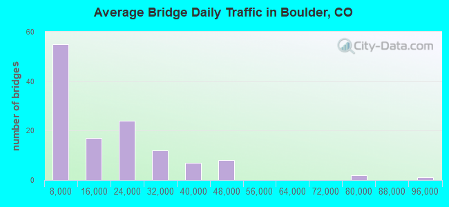
- 1,968,611Total average daily traffic
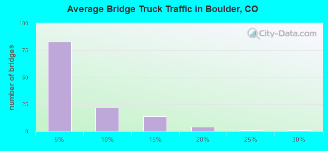
- 80,310Total average daily truck traffic
- National Bridge Inventory (NBI) Registered Bridges for Boulder
- No street view available for this location
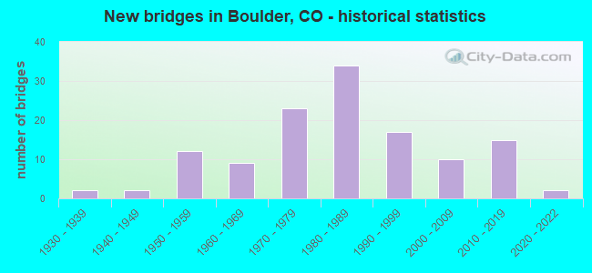
- New bridges - historical statistics
- 21930-1939
- 21940-1949
- 121950-1959
- 91960-1969
- 231970-1979
- 341980-1989
- 171990-1999
- 102000-2009
- 152010-2019
- 22020-2022
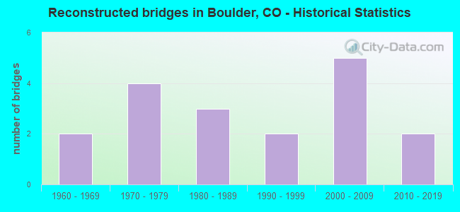
- Reconstructed bridges - Historical Statistics
- 21960-1969
- 41970-1979
- 31980-1989
- 21990-1999
- 52000-2009
- 22010-2019
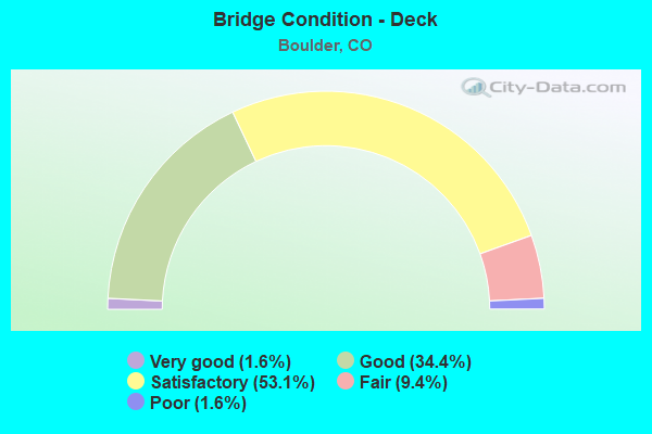
- Bridge Condition - Deck
- 1.6%Very good
- 34.4%Good
- 53.1%Satisfactory
- 9.4%Fair
- 1.6%Poor
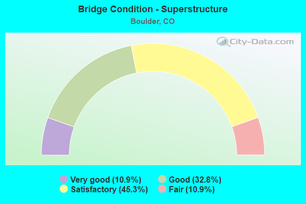
- Bridge Condition - Superstructure
- 10.9%Very good
- 32.8%Good
- 45.3%Satisfactory
- 10.9%Fair
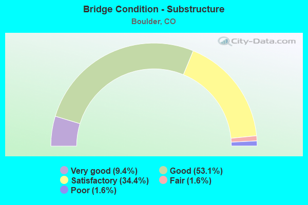
- Bridge Condition - Substructure
- 9.4%Very good
- 53.1%Good
- 34.4%Satisfactory
- 1.6%Fair
- 1.6%Poor
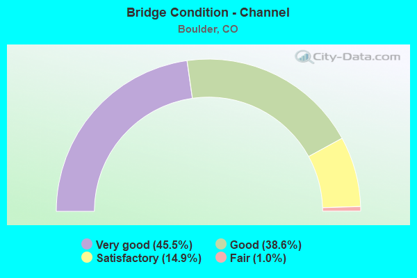
- Bridge Condition - Channel
- 45.5%Very good
- 38.6%Good
- 14.9%Satisfactory
- 1.0%Fair
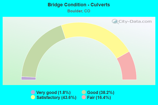
- Bridge Condition - Culverts
- 1.8%Very good
- 38.2%Good
- 43.6%Satisfactory
- 16.4%Fair
Find on map >> Show street view
Structure Number: BC-26-4.1-ID, Location: 0.3 Mi W of Co Rd 41 (Lat: 40.116119, Lng: -105.213397), Route carried "on" structure: County highway , Year Built: 1950, Year Reconstructed: 1985, Status: Open, Structure Length: 0.89m (2.92ft), Average Daily Traffic: 383 (year 2021), Truck Traffic: 21%, Average Future Daily Traffic: 460 (year 2041), Design Load: HS 20, Features Intersected: Boulder Feeder Ditch, Facility Carried by Structure: Oxford Rd (Cr 26)
Minimum Vertical Clearance: 30+ m (98+ ft), Kilometerpoint: 3.875, Lanes on structure: 2, Owner: County Highway Agency, Approaching Roadway Width: 7.3m (24.0ft), Material/Design: Steel, Design/Construction: Stringer/Multi-beam, Number Of Spans In Main Unit: 1, Length of Maximum Span: 8.1m (26.6ft), Curb-To-Curb Width: 8.4m (27.6ft), Out-to-Out Width: 8.6m (28.2ft)
Condition: Deck: Satisfactory, Superstructure: Good, Substructure: Good, Channel: Very good, Operating Rating: 56.2 metric tons, Method Used To Determine Operating Rating: Load Factor (LF), Inventory Rating: 33.7 metric tons, Method Used To Determine Inventory Rating: Load Factor (LF), Structural Evaluation: Better than present minimum criteria, Deck Geometry: Somewhat better than minimum adequacy, Waterway Adequacy: Equal to present desirable criteria, Approach Roadway Alignment: Equal to present desirable criteria, Designated Inspection Frequency: Every 24 months, Inspection Date: Febuary 2021, Deck Structure Type: Corrugated Steel, Wearing Surface/Protective System: Wearing Surface: Bituminous
Find on map >> Show street view
Structure Number: BC-26-5.3-LT1, Location: 0.6 Mi W of Co Rd 33 (Lat: 40.112506, Lng: -105.195139), Route carried "on" structure: County highway , Year Built: 1991, Status: Open, Structure Length: 1.83m (6.00ft), Average Daily Traffic: 239 (year 2021), Truck Traffic: 10%, Average Future Daily Traffic: 287 (year 2041), Design Load: HS 20, Features Intersected: Left Hand Creek, Facility Carried by Structure: County Road 26
Minimum Vertical Clearance: 30+ m (98+ ft), Kilometerpoint: 0.204, Lanes on structure: 2, Owner: County Highway Agency, Approaching Roadway Width: 9.1m (29.9ft), Skew: 2 degrees, Material/Design: Prestressed concrete, Design/Construction: Box Beam or Girders - Single/Spread, Number Of Spans In Main Unit: 1, Length of Maximum Span: 16.4m (53.8ft), Curb or Sidewalk Widths: Left: 0.2m (0.7ft), Right: 0.2m (0.7ft), Curb-To-Curb Width: 9.8m (32.2ft), Out-to-Out Width: 10.7m (35.1ft)
Condition: Deck: Good, Superstructure: Very good, Substructure: Very good, Channel: Very good, Operating Rating: 81.6 metric tons, Method Used To Determine Operating Rating: Load Factor (LF), Inventory Rating: 46.8 metric tons, Method Used To Determine Inventory Rating: Load Factor (LF), Structural Evaluation: Equal to present desirable criteria, Deck Geometry: Better than present minimum criteria, Waterway Adequacy: Better than present minimum criteria, Approach Roadway Alignment: Equal to present desirable criteria, Designated Inspection Frequency: Every 24 months, Inspection Date: Febuary 2021, Deck Structure Type: Concrete Cast-file-Place, Wearing Surface/Protective System: Wearing Surface: Bituminous, Deck Protection: Epoxy Coated Reinforcing
Find on map >> Show street view
Structure Number: BC-30TH-0.5-FMC, Location: 300 Ft N of Palo Parkway (Lat: 40.044711, Lng: -105.253767), Route carried "on" structure: County highway , Year Built: 1973, Status: Open, Structure Length: 2.19m (7.19ft), Average Daily Traffic: 2,308 (year 2021), Truck Traffic: 5%, Average Future Daily Traffic: 2,770 (year 2041), Design Load: HS 20, Features Intersected: Four Mile Creek, Facility Carried by Structure: No. 30th Street
Minimum Vertical Clearance: 30+ m (98+ ft), Kilometerpoint: 0.103, Lanes on structure: 2, Owner: County Highway Agency, Approaching Roadway Width: 11.0m (36.1ft), Material/Design: Prestressed concrete, Design/Construction: Tee Beam, Number Of Spans In Main Unit: 2, Length of Maximum Span: 10.1m (33.1ft), Curb or Sidewalk Widths: Left: 2.1m (6.9ft), Right: 2.1m (6.9ft), Curb-To-Curb Width: 12.3m (40.4ft), Out-to-Out Width: 16.5m (54.1ft)
Condition: Deck: Fair, Superstructure: Fair, Substructure: Good, Channel: Very good, Operating Rating: 32.7 metric tons, Method Used To Determine Operating Rating: Field evaluation and documented engineering judgment, Inventory Rating: 22.7 metric tons, Method Used To Determine Inventory Rating: Field evaluation and documented engineering judgment, Structural Evaluation: Somewhat better than minimum adequacy, Deck Geometry: Equal to present minimum criteria, Waterway Adequacy: Equal to present desirable criteria, Approach Roadway Alignment: Equal to present desirable criteria, Designated Inspection Frequency: Every 24 months, Inspection Date: January 2021, Deck Structure Type: Concrete Cast-file-Place, Wearing Surface/Protective System: Wearing Surface: Bituminous
Find on map >> Show street view
Structure Number: BC-34-3.3-ID-A, Location: 100 Ft. E of N. 55th St (Lat: 40.101636, Lng: -105.225322), Route carried "on" structure: County highway , Year Built: 2010, Status: Open, Structure Length: 1.13m (3.71ft), Average Daily Traffic: 3,017 (year 2021), Truck Traffic: 11%, Average Future Daily Traffic: 3,620 (year 2041), Design Load: HS 20, Features Intersected: Boulder Feeder Ditch, Facility Carried by Structure: Niwot Road CR34
Minimum Vertical Clearance: 30+ m (98+ ft), Kilometerpoint: 2.037, Lanes on structure: 2, Owner: County Highway Agency, Approaching Roadway Width: 9.4m (30.8ft), Material/Design: Prestressed concrete, Design/Construction: Slab, Number Of Spans In Main Unit: 1, Length of Maximum Span: 10.1m (33.1ft), Curb-To-Curb Width: 14.6m (47.9ft), Out-to-Out Width: 15.2m (49.9ft)
Condition: Deck: Very good, Superstructure: Very good, Substructure: Very good, Channel: Very good, Operating Rating: 55.5 metric tons, Method Used To Determine Operating Rating: Load Factor (LF), Inventory Rating: 33.2 metric tons, Method Used To Determine Inventory Rating: Load Factor (LF), Structural Evaluation: Equal to present desirable criteria, Deck Geometry: Superior to present desirable criteria, Waterway Adequacy: Equal to present desirable criteria, Approach Roadway Alignment: Equal to present desirable criteria, Designated Inspection Frequency: Every 24 months, Inspection Date: Febuary 2021, Deck Structure Type: Concrete Cast-file-Place, Wearing Surface/Protective System: Wearing Surface: Bituminous, Membrane: Built-up, Deck Protection: Epoxy Coated Reinforcing
Find on map >> Show street view
Structure Number: BC-39-15.5-ID, Location: 0.9 Mi S of US Hwy 36 (Lat: 39.963739, Lng: -105.212897), Route carried "on" structure: County highway , Year Built: 1986, Status: Open, Structure Length: 0.69m (2.26ft), Average Daily Traffic: 4,189 (year 2020), Truck Traffic: 10%, Average Future Daily Traffic: 5,027 (year 2040), Design Load: HS 20+Mod, Features Intersected: Davidson Ditch, Facility Carried by Structure: Cherryvale Road
Minimum Vertical Clearance: 30+ m (98+ ft), Kilometerpoint: 1.598, Lanes on structure: 2, Owner: County Highway Agency, Approaching Roadway Width: 8.5m (27.9ft), Skew: 4 degrees, Material/Design: Aluminum, Iron, Design/Construction: Culvert, Number Of Spans In Main Unit: 1, Length of Maximum Span: 6.9m (22.6ft), Out-to-Out Width: 15.7m (51.5ft)
Condition: Channel: Good, Culverts: Fair, Inventory Rating: 73.6 metric tons, Method Used To Determine Inventory Rating: Load Factor (LF), Structural Evaluation: Somewhat better than minimum adequacy, Waterway Adequacy: Equal to present desirable criteria, Approach Roadway Alignment: Equal to present minimum criteria, Designated Inspection Frequency: Every 24 months, Inspection Date: Febuary 2021
Find on map >> Show street view
Structure Number: BC-39-4.8-LTA, Location: 0.4 Mi N of Niwot Rd (Lat: 40.107419, Lng: -105.206861), Route carried "on" structure: County highway , Year Built: 2011, Status: Open, Structure Length: 3.81m (12.50ft), Average Daily Traffic: 3,650 (year 2021), Truck Traffic: 11%, Average Future Daily Traffic: 4,380 (year 2041), Design Load: HL 93, Features Intersected: Lefthand Creek, Facility Carried by Structure: N 63rd St (CR39)
Minimum Vertical Clearance: 30+ m (98+ ft), Kilometerpoint: 1.448, Lanes on structure: 2, Owner: County Highway Agency, Approaching Roadway Width: 9.1m (29.9ft), Skew: 3 degrees, Material/Design: Prestressed concrete continuous, Design/Construction: Box Beam or Girders - Single/Spread, Number Of Spans In Main Unit: 2, Length of Maximum Span: 17.5m (57.4ft), Curb-To-Curb Width: 10.4m (34.1ft), Out-to-Out Width: 11.6m (38.1ft)
Condition: Deck: Good, Superstructure: Good, Substructure: Very good, Channel: Good, Operating Rating: 42.1 metric tons, Method Used To Determine Operating Rating: Load and Resistance Factor Rating (LRFR) rating reported by rating factor(RF) method using HL-93 loadings, Inventory Rating: 26.9 metric tons, Method Used To Determine Inventory Rating: Load and Resistance Factor Rating (LRFR) rating reported by rating factor(RF) method using HL-93 loadings, Structural Evaluation: Equal to present minimum criteria, Deck Geometry: Somewhat better than minimum adequacy, Waterway Adequacy: Equal to present desirable criteria, Approach Roadway Alignment: Equal to present desirable criteria, Designated Inspection Frequency: Every 24 months, Inspection Date: Febuary 2021, Deck Structure Type: Concrete Precast Panels, Wearing Surface/Protective System: Wearing Surface: Bituminous, Membrane: Built-up, Deck Protection: Epoxy Coated Reinforcing
Find on map >> Show street view
Structure Number: BC-426606-0.4A, Location: .4 Mi S of Neva Rd (Lat: 40.099361, Lng: -105.259194), Route carried "on" structure: County highway , Year Built: 2005, Status: Open, Structure Length: 1.39m (4.56ft), Average Daily Traffic: 773 (year 2021), Truck Traffic: 10%, Average Future Daily Traffic: 928 (year 2041), Features Intersected: Local Drainage, Facility Carried by Structure: Fairways Drive
Minimum Vertical Clearance: 30+ m (98+ ft), Kilometerpoint: 1.254, Lanes on structure: 2, Owner: County Highway Agency, Approaching Roadway Width: 12.2m (40.0ft), Skew: 3 degrees, Material/Design: Concrete, Design/Construction: Culvert, Number Of Spans In Main Unit: 3, Length of Maximum Span: 4.9m (16.1ft), Out-to-Out Width: 21.1m (69.2ft)
Condition: Channel: Good, Culverts: Good, Operating Rating: 36.3 metric tons, Method Used To Determine Operating Rating: Field evaluation and documented engineering judgment, Inventory Rating: 32.7 metric tons, Method Used To Determine Inventory Rating: Field evaluation and documented engineering judgment, Structural Evaluation: Better than present minimum criteria, Waterway Adequacy: Equal to present desirable criteria, Approach Roadway Alignment: Better than present minimum criteria, Designated Inspection Frequency: Every 24 months, Inspection Date: Febuary 2021
Find on map >> Show street view
Structure Number: BC-46-1.6-ID, Location: 0.4 Mi E of St Hwy 119 (Lat: 40.040114, Lng: -105.235661), Route carried "on" structure: County highway , Year Built: 1973, Status: Open, Structure Length: 0.61m (2.00ft), Average Daily Traffic: 1,109 (year 2021), Truck Traffic: 4%, Average Future Daily Traffic: 1,331 (year 2041), Design Load: HS 20, Features Intersected: Boulder & Whiterock Dtch, Facility Carried by Structure: Independence Ave.
Minimum Vertical Clearance: 30+ m (98+ ft), Kilometerpoint: 0.620, Lanes on structure: 2, Owner: County Highway Agency, Approaching Roadway Width: 7.3m (24.0ft), Skew: 3 degrees, Material/Design: Concrete, Design/Construction: Culvert, Number Of Spans In Main Unit: 1, Length of Maximum Span: 6.1m (20.0ft), Curb-To-Curb Width: 11.2m (36.7ft), Out-to-Out Width: 11.8m (38.7ft)
Condition: Channel: Satisfactory, Culverts: Satisfactory, Operating Rating: 36.3 metric tons, Method Used To Determine Operating Rating: Field evaluation and documented engineering judgment, Inventory Rating: 32.7 metric tons, Method Used To Determine Inventory Rating: Field evaluation and documented engineering judgment, Structural Evaluation: Equal to present minimum criteria, Deck Geometry: Equal to present minimum criteria, Waterway Adequacy: Equal to present desirable criteria, Approach Roadway Alignment: Equal to present desirable criteria, Designated Inspection Frequency: Every 24 months, Inspection Date: January 2021
Find on map >> Show street view
Structure Number: BC-51-5.3-LT1, Location: 0.5 Mi N of Co Rd 34 (Lat: 40.108606, Lng: -105.239831), Route carried "on" structure: County highway , Year Built: 1993, Status: Open, Structure Length: 1.77m (5.81ft), Average Daily Traffic: 257 (year 2021), Truck Traffic: 14%, Average Future Daily Traffic: 308 (year 2041), Design Load: HS 20, Features Intersected: Left Hand Creek, Facility Carried by Structure: N 49th St (Cr 51)
Minimum Vertical Clearance: 30+ m (98+ ft), Kilometerpoint: 0.758, Lanes on structure: 2, Owner: County Highway Agency, Approaching Roadway Width: 7.3m (24.0ft), Skew: 2 degrees, Material/Design: Prestressed concrete, Design/Construction: Box Beam or Girders - Single/Spread, Number Of Spans In Main Unit: 1, Length of Maximum Span: 16.5m (54.1ft), Curb or Sidewalk Widths: Left: 0.2m (0.7ft), Right: 0.2m (0.7ft), Curb-To-Curb Width: 9.9m (32.5ft), Out-to-Out Width: 10.8m (35.4ft)
Condition: Deck: Good, Superstructure: Very good, Substructure: Good, Channel: Satisfactory, Operating Rating: 66.4 metric tons, Method Used To Determine Operating Rating: Load Factor (LF), Inventory Rating: 36.9 metric tons, Method Used To Determine Inventory Rating: Load Factor (LF), Structural Evaluation: Better than present minimum criteria, Deck Geometry: Better than present minimum criteria, Waterway Adequacy: Better than present minimum criteria, Approach Roadway Alignment: Equal to present desirable criteria, Designated Inspection Frequency: Every 24 months, Inspection Date: Febuary 2021, Deck Structure Type: Concrete Cast-file-Place, Wearing Surface/Protective System: Wearing Surface: Bituminous, Membrane: Built-up, Deck Protection: Epoxy Coated Reinforcing
Find on map >> Show street view
Structure Number: BC-52-1.9-BO1, Location: 200 Ft. E of 55th Street (Lat: 40.028358, Lng: -105.223664), Route carried "on" structure: County highway , Year Built: 1999, Status: Open, Structure Length: 5.76m (18.90ft), Average Daily Traffic: 17,106 (year 2021), Truck Traffic: 14%, Average Future Daily Traffic: 20,527 (year 2041), Design Load: HS 20, Features Intersected: Boulder Creek, Facility Carried by Structure: Valmont Rd
Minimum Vertical Clearance: 30+ m (98+ ft), Kilometerpoint: 0.140, Lanes on structure: 4, Owner: County Highway Agency, Approaching Roadway Width: 18.3m (60.0ft), Material/Design: Prestressed concrete continuous, Design/Construction: Box Beam or Girders - Multiple, Number Of Spans In Main Unit: 2, Length of Maximum Span: 27.4m (89.9ft), Curb-To-Curb Width: 18.3m (60.0ft), Out-to-Out Width: 19.1m (62.7ft)
Condition: Deck: Good, Superstructure: Good, Substructure: Good, Channel: Very good, Inventory Rating: 69.4 metric tons, Method Used To Determine Inventory Rating: Load Factor (LF), Structural Evaluation: Better than present minimum criteria, Deck Geometry: Somewhat better than minimum adequacy, Waterway Adequacy: Equal to present desirable criteria, Approach Roadway Alignment: Equal to present desirable criteria, Designated Inspection Frequency: Every 24 months, Inspection Date: Febuary 2021, Deck Structure Type: Concrete Cast-file-Place, Wearing Surface/Protective System: Wearing Surface: Bituminous, Membrane: Built-up, Deck Protection: Epoxy Coated Reinforcing
Find on map >> Show street view
Structure Number: BC-56-0.5-SB, Location: 0.1 Mi W of Cherryvale Rd (Lat: 40.000061, Lng: -105.215536), Route carried "on" structure: County highway , Year Built: 1980, Status: Open, Structure Length: 1.32m (4.33ft), Average Daily Traffic: 7,721 (year 2021), Truck Traffic: 3%, Average Future Daily Traffic: 9,265 (year 2041), Design Load: HS 20, Features Intersected: South Boulder Creek, Facility Carried by Structure: Baseline Road
Minimum Vertical Clearance: 30+ m (98+ ft), Kilometerpoint: 0.441, Lanes on structure: 2, Owner: County Highway Agency, Approaching Roadway Width: 10.7m (35.1ft), Material/Design: Prestressed concrete, Design/Construction: Tee Beam, Number Of Spans In Main Unit: 1, Length of Maximum Span: 11.6m (38.1ft), Curb-To-Curb Width: 11.1m (36.4ft), Out-to-Out Width: 11.8m (38.7ft)
Condition: Deck: Satisfactory, Superstructure: Fair, Substructure: Good, Channel: Very good, Operating Rating: 49.1 metric tons, Method Used To Determine Operating Rating: Load Factor (LF), Inventory Rating: 35.2 metric tons, Method Used To Determine Inventory Rating: Load Factor (LF), Structural Evaluation: Somewhat better than minimum adequacy, Deck Geometry: Meets minimum limits, Waterway Adequacy: Equal to present desirable criteria, Approach Roadway Alignment: Equal to present desirable criteria, Designated Inspection Frequency: Every 24 months, Inspection Date: Febuary 2021, Deck Structure Type: Concrete Cast-file-Place, Wearing Surface/Protective System: Wearing Surface: Bituminous
Find on map >> Show street view
Structure Number: BC-56-00.85-SS, Location: 1.0 Mi W of Baseline Rd (Lat: 40.002756, Lng: -105.292172), Route carried "on" structure: County highway , Year Built: 2014, Status: Open, Structure Length: 4.92m (16.14ft), Average Daily Traffic: 3,336 (year 2021), Truck Traffic: 2%, Average Future Daily Traffic: 4,003 (year 2041), Design Load: HL 93, Features Intersected: HIllside Slide, Facility Carried by Structure: Flagstaff Rd CR56
Minimum Vertical Clearance: 30+ m (98+ ft), Kilometerpoint: 4.212, Lanes on structure: 2, Owner: County Highway Agency, Approaching Roadway Width: 7.3m (24.0ft), Material/Design: Concrete continuous, Design/Construction: Slab, Number Of Spans In Main Unit: 4, Length of Maximum Span: 11.6m (38.1ft), Curb-To-Curb Width: 6.5m (21.3ft), Out-to-Out Width: 6.9m (22.6ft)
Condition: Deck: Good, Superstructure: Good, Substructure: Very good, Operating Rating: 50.2 metric tons, Method Used To Determine Operating Rating: Load and Resistance Factor Rating (LRFR) rating reported by rating factor(RF) method using HL-93 loadings, Inventory Rating: 38.9 metric tons, Method Used To Determine Inventory Rating: Load and Resistance Factor Rating (LRFR) rating reported by rating factor(RF) method using HL-93 loadings, Structural Evaluation: Better than present minimum criteria, Deck Geometry: High priority of replacement, Approach Roadway Alignment: Better than present minimum criteria, Designated Inspection Frequency: Every 24 months, Inspection Date: January 2021, Deck Structure Type: Concrete Cast-file-Place, Wearing Surface/Protective System: Wearing Surface: Bituminous, Membrane: Epoxy, Deck Protection: Epoxy Coated Reinforcing
Find on map >> Show street view
Structure Number: BC-56-00.9-SS, Location: 1.0 Mi W of Baseline Rd (Lat: 40.002939, Lng: -105.292336), Route carried "on" structure: County highway , Year Built: 1996, Status: Open, Structure Length: 5.18m (16.99ft), Average Daily Traffic: 3,336 (year 2021), Truck Traffic: 2%, Average Future Daily Traffic: 4,003 (year 2041), Design Load: HS 20, Features Intersected: Hillside Slide, Facility Carried by Structure: Flagstaff Rd CR56
Minimum Vertical Clearance: 30+ m (98+ ft), Kilometerpoint: 4.194, Lanes on structure: 2, Owner: County Highway Agency, Approaching Roadway Width: 7.3m (24.0ft), Material/Design: Concrete continuous, Design/Construction: Slab, Number Of Spans In Main Unit: 6, Length of Maximum Span: 9.1m (29.9ft), Curb-To-Curb Width: 6.5m (21.3ft), Out-to-Out Width: 6.9m (22.6ft)
Condition: Deck: Good, Superstructure: Good, Substructure: Very good, Operating Rating: 69.2 metric tons, Method Used To Determine Operating Rating: Load Factor (LF), Inventory Rating: 41.5 metric tons, Method Used To Determine Inventory Rating: Load Factor (LF), Structural Evaluation: Better than present minimum criteria, Deck Geometry: High priority of replacement, Approach Roadway Alignment: Better than present minimum criteria, Length Of Structure Improvement: 5.18m (16.99ft), Designated Inspection Frequency: Every 24 months, Inspection Date: January 2021, Bridge Improvement Cost: $805,000, Roadway Improvement Cost: $81,000, Total Project Cost: $886,000 ( Estimate for 2019), Deck Structure Type: Concrete Cast-file-Place, Wearing Surface/Protective System: Wearing Surface: Bituminous, Deck Protection: Epoxy Coated Reinforcing
Find on map >> Show street view
Structure Number: BC-580802-0.1, Location: 0.1 Mi So of Hogan Ct (Lat: 40.093839, Lng: -105.251278), Route carried "on" structure: County highway , Year Built: 2005, Status: Open, Structure Length: 0.96m (3.15ft), Average Daily Traffic: 986 (year 2021), Truck Traffic: 8%, Average Future Daily Traffic: 1,183 (year 2041), Features Intersected: Local Drainage, Facility Carried by Structure: Golf Club Drive
Minimum Vertical Clearance: 30+ m (98+ ft), Kilometerpoint: 0.760, Lanes on structure: 2, Owner: County Highway Agency, Approaching Roadway Width: 7.9m (25.9ft), Material/Design: Concrete, Design/Construction: Culvert, Number Of Spans In Main Unit: 3, Length of Maximum Span: 3.7m (12.1ft), Curb-To-Curb Width: 8.8m (28.9ft), Out-to-Out Width: 9.7m (31.8ft)
Condition: Channel: Good, Culverts: Good, Operating Rating: 36.3 metric tons, Method Used To Determine Operating Rating: Field evaluation and documented engineering judgment, Inventory Rating: 32.7 metric tons, Method Used To Determine Inventory Rating: Field evaluation and documented engineering judgment, Structural Evaluation: Better than present minimum criteria, Deck Geometry: Somewhat better than minimum adequacy, Waterway Adequacy: Equal to present desirable criteria, Approach Roadway Alignment: Equal to present desirable criteria, Designated Inspection Frequency: Every 24 months, Inspection Date: Febuary 2021, Wearing Surface/Protective System: Wearing Surface: Bituminous
Find on map >> Show street view
Structure Number: BC-580802-0.4, Location: 0.4 Mi So of Hogan Ct (Lat: 40.089614, Lng: -105.252514), Route carried "on" structure: County highway , Year Built: 2005, Status: Open, Structure Length: 0.95m (3.12ft), Average Daily Traffic: 556 (year 2021), Truck Traffic: 9%, Average Future Daily Traffic: 667 (year 2041), Features Intersected: Local Drainage, Facility Carried by Structure: Golf Club Drive
Minimum Vertical Clearance: 30+ m (98+ ft), Kilometerpoint: 0.260, Lanes on structure: 2, Owner: County Highway Agency, Approaching Roadway Width: 7.6m (24.9ft), Material/Design: Concrete, Design/Construction: Culvert, Number Of Spans In Main Unit: 3, Length of Maximum Span: 3.6m (11.8ft), Curb-To-Curb Width: 10.3m (33.8ft), Out-to-Out Width: 11.2m (36.7ft)
Condition: Channel: Satisfactory, Culverts: Good, Operating Rating: 36.3 metric tons, Method Used To Determine Operating Rating: Field evaluation and documented engineering judgment, Inventory Rating: 32.7 metric tons, Method Used To Determine Inventory Rating: Field evaluation and documented engineering judgment, Structural Evaluation: Better than present minimum criteria, Deck Geometry: Equal to present minimum criteria, Waterway Adequacy: Equal to present desirable criteria, Approach Roadway Alignment: Better than present minimum criteria, Designated Inspection Frequency: Every 24 months, Inspection Date: Febuary 2021, Deck Structure Type: Concrete Cast-file-Place, Wearing Surface/Protective System: Wearing Surface: Bituminous
Find on map >> Show street view
Structure Number: BC-60-0.3-VC-1, Location: 0.6 Mi E of US Hwy 36 (Lat: 39.985761, Lng: -105.223411), Route carried "on" structure: County highway , Year Built: 1975, Year Reconstructed: 1986, Status: Open, Structure Length: 1.30m (4.27ft), Average Daily Traffic: 15,174 (year 2021), Truck Traffic: 4%, Average Future Daily Traffic: 18,209 (year 2041), Design Load: HS 20, Features Intersected: Viele Channel (Ditch), Facility Carried by Structure: South Boulder Road
Minimum Vertical Clearance: 30+ m (98+ ft), Kilometerpoint: 0.235, Lanes on structure: 4, Owner: County Highway Agency, Approaching Roadway Width: 20.7m (67.9ft), Skew: 32 degrees, Material/Design: Concrete, Design/Construction: Culvert, Number Of Spans In Main Unit: 3, Length of Maximum Span: 4.9m (16.1ft), Curb-To-Curb Width: 20.7m (67.9ft), Out-to-Out Width: 27.9m (91.5ft)
Condition: Channel: Good, Culverts: Satisfactory, Operating Rating: 36.3 metric tons, Method Used To Determine Operating Rating: Field evaluation and documented engineering judgment, Inventory Rating: 32.7 metric tons, Method Used To Determine Inventory Rating: Field evaluation and documented engineering judgment, Structural Evaluation: Equal to present minimum criteria, Deck Geometry: Superior to present desirable criteria, Waterway Adequacy: Equal to present desirable criteria, Approach Roadway Alignment: Equal to present desirable criteria, Designated Inspection Frequency: Every 24 months, Inspection Date: Febuary 2021
Find on map >> Show street view
Structure Number: BC-60-0.4-SB-1, Location: 0.4 Mi E of US Hwy 36 (Lat: 39.985789, Lng: -105.221264), Route carried "on" structure: County highway , Year Built: 1986, Status: Open, Structure Length: 3.68m (12.07ft), Average Daily Traffic: 15,174 (year 2021), Truck Traffic: 4%, Average Future Daily Traffic: 18,209 (year 2041), Design Load: HS 20+Mod, Features Intersected: South Boulder Creek, Facility Carried by Structure: S Boulder Road
Minimum Vertical Clearance: 30+ m (98+ ft), Kilometerpoint: 0.415, Lanes on structure: 4, Base Highway Network: Yes, Owner: County Highway Agency, Approaching Roadway Width: 20.3m (66.6ft), Skew: 33 degrees, Material/Design: Prestressed concrete continuous, Design/Construction: Tee Beam, Number Of Spans In Main Unit: 2, Length of Maximum Span: 16.9m (55.4ft), Curb-To-Curb Width: 20.2m (66.3ft), Out-to-Out Width: 25.2m (82.7ft)
Condition: Deck: Good, Superstructure: Satisfactory, Substructure: Good, Channel: Satisfactory, Operating Rating: 36.3 metric tons, Method Used To Determine Operating Rating: Field evaluation and documented engineering judgment, Inventory Rating: 32.7 metric tons, Method Used To Determine Inventory Rating: Field evaluation and documented engineering judgment, Structural Evaluation: Equal to present minimum criteria, Deck Geometry: Better than present minimum criteria, Waterway Adequacy: Equal to present desirable criteria, Approach Roadway Alignment: Equal to present desirable criteria, Designated Inspection Frequency: Every 24 months, Inspection Date: Febuary 2021, Deck Structure Type: Concrete Cast-file-Place, Wearing Surface/Protective System: Wearing Surface: Bituminous, Membrane: Built-up, Deck Protection: Epoxy Coated Reinforcing
Find on map >> Show street view
Structure Number: BC-O-OSJ-9A, Location: 50 Ft E of Stirrup Lane (Lat: 40.127936, Lng: -105.220053), Route carried "on" structure: County highway , Year Built: 1980, Status: Open, Structure Length: 1.40m (4.59ft), Average Daily Traffic: 349 (year 2021), Truck Traffic: 18%, Average Future Daily Traffic: 419 (year 2041), Design Load: HS 20, Features Intersected: Boulder Feeder Ditch, Facility Carried by Structure: Boulder Hills Dr
Minimum Vertical Clearance: 30+ m (98+ ft), Kilometerpoint: 0.528, Lanes on structure: 2, Owner: County Highway Agency, Approaching Roadway Width: 9.1m (29.9ft), Material/Design: Prestressed concrete, Design/Construction: Tee Beam, Number Of Spans In Main Unit: 1, Length of Maximum Span: 12.6m (41.3ft), Curb-To-Curb Width: 11.0m (36.1ft), Out-to-Out Width: 11.9m (39.0ft)
Condition: Deck: Fair, Superstructure: Satisfactory, Substructure: Good, Channel: Very good, Operating Rating: 36.3 metric tons, Method Used To Determine Operating Rating: Field evaluation and documented engineering judgment, Inventory Rating: 32.7 metric tons, Method Used To Determine Inventory Rating: Field evaluation and documented engineering judgment, Structural Evaluation: Equal to present minimum criteria, Deck Geometry: Equal to present desirable criteria, Waterway Adequacy: Equal to present desirable criteria, Approach Roadway Alignment: Equal to present desirable criteria, Designated Inspection Frequency: Every 24 months, Inspection Date: Febuary 2021, Deck Structure Type: Concrete Cast-file-Place, Wearing Surface/Protective System: Wearing Surface: Monolithic Concrete
Find on map >> Show street view
Structure Number: BC-O-OSK-9A, Location: 0.2 Mi N of Niwot Rd (Lat: 40.104583, Lng: -105.211694), Route carried "on" structure: County highway , Year Built: 1970, Status: Open, Structure Length: 0.88m (2.89ft), Average Daily Traffic: 118 (year 2021), Truck Traffic: 17%, Average Future Daily Traffic: 142 (year 2041), Design Load: HS 20, Features Intersected: Left Hand Creek, Facility Carried by Structure: Strath Street
Minimum Vertical Clearance: 30+ m (98+ ft), Kilometerpoint: 0.317, Lanes on structure: 2, Owner: County Highway Agency, Approaching Roadway Width: 7.3m (24.0ft), Material/Design: Concrete, Design/Construction: Culvert, Number Of Spans In Main Unit: 2, Length of Maximum Span: 4.3m (14.1ft), Curb-To-Curb Width: 10.0m (32.8ft), Out-to-Out Width: 10.4m (34.1ft)
Condition: Channel: Good, Culverts: Satisfactory, Operating Rating: 36.3 metric tons, Method Used To Determine Operating Rating: Field evaluation and documented engineering judgment, Inventory Rating: 32.7 metric tons, Method Used To Determine Inventory Rating: Field evaluation and documented engineering judgment, Structural Evaluation: Equal to present minimum criteria, Deck Geometry: Better than present minimum criteria, Waterway Adequacy: Better than present minimum criteria, Approach Roadway Alignment: Equal to present desirable criteria, Designated Inspection Frequency: Every 24 months, Inspection Date: Febuary 2021, Wearing Surface/Protective System: Wearing Surface: Bituminous
Find on map >> Show street view
Structure Number: BC-O-OSR-9B, Location: 0.1 Mi W of Cherryvale Rd (Lat: 40.008931, Lng: -105.215125), Route carried "on" structure: County highway , Year Built: 1970, Status: Open, Structure Length: 1.61m (5.28ft), Average Daily Traffic: 198 (year 2021), Truck Traffic: 6%, Average Future Daily Traffic: 238 (year 2041), Features Intersected: South Boulder Creek, Facility Carried by Structure: Mc Sorley Lane
Minimum Vertical Clearance: 30+ m (98+ ft), Kilometerpoint: 0.076, Lanes on structure: 2, Owner: City or Municipal Highway Agency, Approaching Roadway Width: 6.7m (22.0ft), Material/Design: Prestressed concrete, Design/Construction: Tee Beam, Number Of Spans In Main Unit: 2, Length of Maximum Span: 7.6m (24.9ft), Curb-To-Curb Width: 7.6m (24.9ft), Out-to-Out Width: 8.5m (27.9ft)
Condition: Deck: Satisfactory, Superstructure: Satisfactory, Substructure: Satisfactory, Channel: Good, Operating Rating: 36.3 metric tons, Method Used To Determine Operating Rating: Field evaluation and documented engineering judgment, Inventory Rating: 32.7 metric tons, Method Used To Determine Inventory Rating: Field evaluation and documented engineering judgment, Structural Evaluation: Equal to present minimum criteria, Deck Geometry: Somewhat better than minimum adequacy, Waterway Adequacy: Equal to present desirable criteria, Approach Roadway Alignment: Equal to present desirable criteria, Designated Inspection Frequency: Every 24 months, Inspection Date: Febuary 2021, Deck Structure Type: Concrete Cast-file-Place, Wearing Surface/Protective System: Wearing Surface: Monolithic Concrete
Find on map >> Show street view
Structure Number: BOLD-01-0.05-01, Location: 0.1 Mi So of Canyon Blvd (Lat: 40.013567, Lng: -105.287172), Route carried "on" structure: City street , Year Built: 1978, Status: Open, Structure Length: 3.72m (12.20ft), Average Daily Traffic: 2,412 (year 2021), Truck Traffic: 3%, Average Future Daily Traffic: 2,894 (year 2041), Design Load: HS 20, Features Intersected: Boulder Creek, Facility Carried by Structure: 6th Street
Minimum Vertical Clearance: 30+ m (98+ ft), Kilometerpoint: 0.910, Lanes on structure: 2, Owner: City or Municipal Highway Agency, Approaching Roadway Width: 6.7m (22.0ft), Skew: 1 degrees, Material/Design: Prestressed concrete, Design/Construction: Tee Beam, Number Of Spans In Main Unit: 2, Length of Maximum Span: 18.2m (59.7ft), Curb or Sidewalk Widths: Left: 1.9m (6.2ft), Right: 1.3m (4.3ft), Curb-To-Curb Width: 6.7m (22.0ft), Out-to-Out Width: 10.9m (35.8ft)
Condition: Deck: Satisfactory, Superstructure: Satisfactory, Substructure: Satisfactory, Channel: Very good, Operating Rating: 36.3 metric tons, Method Used To Determine Operating Rating: Field evaluation and documented engineering judgment, Inventory Rating: 28.3 metric tons, Method Used To Determine Inventory Rating: Load Factor (LF), Structural Evaluation: Equal to present minimum criteria, Deck Geometry: High priority of replacement, Waterway Adequacy: Equal to present desirable criteria, Approach Roadway Alignment: Equal to present desirable criteria, Length Of Structure Improvement: 3.72m (12.20ft), Designated Inspection Frequency: Every 24 months, Inspection Date: Febuary 2021, Bridge Improvement Cost: $680,000, Roadway Improvement Cost: $68,000, Total Project Cost: $748,000 ( Estimate for 2019), Deck Structure Type: Other, Wearing Surface/Protective System: Wearing Surface: Bituminous
Find on map >> Show street view
Structure Number: BOLD-02-0.08-01, Location: 0.08 Mi N of Arapahoe Ave (Lat: 40.013978, Lng: -105.283353), Route carried "on" structure: City street , Year Built: 1978, Status: Open, Structure Length: 4.42m (14.50ft), Average Daily Traffic: 10,838 (year 2021), Truck Traffic: 4%, Average Future Daily Traffic: 13,006 (year 2041), Design Load: HS 20, Features Intersected: Boulder Creek, Facility Carried by Structure: 9th Street
Minimum Vertical Clearance: 30+ m (98+ ft), Kilometerpoint: 1.586, Lanes on structure: 2, Owner: City or Municipal Highway Agency, Approaching Roadway Width: 11.0m (36.1ft), Skew: 2 degrees, Material/Design: Prestressed concrete, Design/Construction: Box Beam or Girders - Single/Spread, Number Of Spans In Main Unit: 2, Length of Maximum Span: 21.1m (69.2ft), Curb or Sidewalk Widths: Left: 1.9m (6.2ft), Right: 1.9m (6.2ft), Curb-To-Curb Width: 11.0m (36.1ft), Out-to-Out Width: 15.8m (51.8ft)
Condition: Deck: Satisfactory, Superstructure: Satisfactory, Substructure: Satisfactory, Channel: Good, Operating Rating: 36.3 metric tons, Method Used To Determine Operating Rating: Field evaluation and documented engineering judgment, Inventory Rating: 32.7 metric tons, Method Used To Determine Inventory Rating: Field evaluation and documented engineering judgment, Structural Evaluation: Equal to present minimum criteria, Deck Geometry: Meets minimum limits, Waterway Adequacy: Equal to present desirable criteria, Approach Roadway Alignment: Equal to present desirable criteria, Designated Inspection Frequency: Every 24 months, Inspection Date: Febuary 2021, Deck Structure Type: Concrete Cast-file-Place, Wearing Surface/Protective System: Wearing Surface: Bituminous
Find on map >> Show street view
Structure Number: BOLD-03-0.36-1A, Location: 0.4 Mi So of Canyon Blvd. (Lat: 40.011728, Lng: -105.272464), Route carried "on" structure: City street , Year Built: 1985, Status: Open, Structure Length: 3.19m (10.47ft), Average Daily Traffic: 8,585 (year 2021), Truck Traffic: 2%, Average Future Daily Traffic: 10,302 (year 2041), Features Intersected: Boulder Creek, Facility Carried by Structure: 17th Street
Minimum Vertical Clearance: 30+ m (98+ ft), Kilometerpoint: 0.184, Lanes on structure: 2, Owner: City or Municipal Highway Agency, Approaching Roadway Width: 9.8m (32.2ft), Material/Design: Prestressed concrete, Design/Construction: Box Beam or Girders - Multiple, Number Of Spans In Main Unit: 1, Length of Maximum Span: 30.2m (99.1ft), Curb or Sidewalk Widths: Left: 1.5m (4.9ft), Right: 2.3m (7.5ft), Curb-To-Curb Width: 9.8m (32.2ft), Out-to-Out Width: 17.0m (55.8ft)
Condition: Deck: Good, Superstructure: Satisfactory, Substructure: Satisfactory, Channel: Good, Operating Rating: 59.9 metric tons, Method Used To Determine Operating Rating: Load Factor (LF), Inventory Rating: 39.0 metric tons, Method Used To Determine Inventory Rating: Load Factor (LF), Structural Evaluation: Equal to present minimum criteria, Deck Geometry: Meets minimum limits, Waterway Adequacy: Equal to present desirable criteria, Approach Roadway Alignment: Equal to present desirable criteria, Designated Inspection Frequency: Every 24 months, Inspection Date: Febuary 2021, Deck Structure Type: Concrete Cast-file-Place, Wearing Surface/Protective System: Wearing Surface: Bituminous
Find on map >> Show street view
Structure Number: BOLD-04-0.39-03, Location: 20 Ft N of Pearl Street (Lat: 40.021542, Lng: -105.263025), Route carried "on" structure: City street , Year Built: 1970, Status: Open, Structure Length: 0.73m (2.40ft), Average Daily Traffic: 17,292 (year 2021), Truck Traffic: 5%, Average Future Daily Traffic: 20,750 (year 2041), Design Load: HS 20, Features Intersected: Boulder Whiterock Ditch, Facility Carried by Structure: Folsom Street
Minimum Vertical Clearance: 30+ m (98+ ft), Kilometerpoint: 1.485, Lanes on structure: 5, Owner: City or Municipal Highway Agency, Approaching Roadway Width: 19.5m (64.0ft), Skew: 24 degrees, Material/Design: Concrete, Design/Construction: Slab, Number Of Spans In Main Unit: 1, Length of Maximum Span: 6.7m (22.0ft), Curb or Sidewalk Widths: Left: 1.6m (5.2ft), Right: 1.3m (4.3ft), Curb-To-Curb Width: 19.4m (63.6ft), Out-to-Out Width: 24.0m (78.7ft)
Condition: Deck: Satisfactory, Superstructure: Satisfactory, Substructure: Good, Channel: Good, Operating Rating: 36.3 metric tons, Method Used To Determine Operating Rating: Field evaluation and documented engineering judgment, Inventory Rating: 32.7 metric tons, Method Used To Determine Inventory Rating: Field evaluation and documented engineering judgment, Structural Evaluation: Equal to present minimum criteria, Deck Geometry: Meets minimum limits, Waterway Adequacy: Equal to present desirable criteria, Approach Roadway Alignment: Equal to present desirable criteria, Designated Inspection Frequency: Every 24 months, Inspection Date: Febuary 2021, Deck Structure Type: Concrete Cast-file-Place, Wearing Surface/Protective System: Wearing Surface: Bituminous
Find on map >> Show street view
Structure Number: BOLD-04-0.40-01, Location: 0.40 Mi S of Canyon Blvd (Lat: 40.011342, Lng: -105.263256), Route carried "on" structure: City street , Year Built: 1965, Status: Open, Structure Length: 1.83m (6.00ft), Average Daily Traffic: 7,053 (year 2021), Truck Traffic: 4%, Average Future Daily Traffic: 8,464 (year 2041), Design Load: HS 20, Features Intersected: Boulder Creek, Facility Carried by Structure: Folsom Street
Minimum Vertical Clearance: 30+ m (98+ ft), Kilometerpoint: 0.383, Lanes on structure: 2, Owner: City or Municipal Highway Agency, Approaching Roadway Width: 13.4m (44.0ft), Material/Design: Prestressed concrete, Design/Construction: Stringer/Multi-beam, Number Of Spans In Main Unit: 1, Length of Maximum Span: 17.4m (57.1ft), Curb or Sidewalk Widths: Left: 1.6m (5.2ft), Right: 1.6m (5.2ft), Curb-To-Curb Width: 13.5m (44.3ft), Out-to-Out Width: 17.1m (56.1ft)
Condition: Deck: Fair, Superstructure: Good, Substructure: Good, Channel: Good, Operating Rating: 35.9 metric tons, Method Used To Determine Operating Rating: Load Factor (LF), Inventory Rating: 21.6 metric tons, Method Used To Determine Inventory Rating: Load Factor (LF), Structural Evaluation: Somewhat better than minimum adequacy, Deck Geometry: Superior to present desirable criteria, Waterway Adequacy: Equal to present desirable criteria, Approach Roadway Alignment: Equal to present desirable criteria, Designated Inspection Frequency: Every 24 months, Inspection Date: Febuary 2021, Deck Structure Type: Concrete Cast-file-Place, Wearing Surface/Protective System: Wearing Surface: Bituminous
Find on map >> Show street view
Structure Number: BOLD-04-0.74-4A, Location: 300 Ft. So. of Valmont (Lat: 40.027825, Lng: -105.263006), Route carried "on" structure: City street , Year Built: 1970, Year Reconstructed: 1982, Status: Open, Structure Length: 1.26m (4.13ft), Average Daily Traffic: 14,415 (year 2021), Truck Traffic: 4%, Average Future Daily Traffic: 17,298 (year 2041), Design Load: HS 20, Features Intersected: Goose Creek, Facility Carried by Structure: Folsom Street
Minimum Vertical Clearance: 30+ m (98+ ft), Kilometerpoint: 2.227, Lanes on structure: 3, Owner: City or Municipal Highway Agency, Approaching Roadway Width: 15.5m (50.9ft), Skew: 1 degrees, Material/Design: Prestressed concrete, Design/Construction: Tee Beam, Number Of Spans In Main Unit: 1, Length of Maximum Span: 11.9m (39.0ft), Curb or Sidewalk Widths: Left: 2.0m (6.6ft), Right: 2.0m (6.6ft), Curb-To-Curb Width: 15.5m (50.9ft), Out-to-Out Width: 20.1m (65.9ft)
Condition: Deck: Satisfactory, Superstructure: Satisfactory, Substructure: Satisfactory, Channel: Very good, Operating Rating: 37.6 metric tons, Method Used To Determine Operating Rating: Load Factor (LF), Inventory Rating: 22.6 metric tons, Method Used To Determine Inventory Rating: Load Factor (LF), Structural Evaluation: Somewhat better than minimum adequacy, Deck Geometry: Equal to present minimum criteria, Waterway Adequacy: Equal to present desirable criteria, Approach Roadway Alignment: Equal to present desirable criteria, Designated Inspection Frequency: Every 24 months, Inspection Date: Febuary 2021, Deck Structure Type: Other, Wearing Surface/Protective System: Wearing Surface: Bituminous
Find on map >> Show street view
Structure Number: BOLD-05-0.10-01, Location: 0.1 Mi E of N 55th Street (Lat: 40.023622, Lng: -105.222939), Route carried "on" structure: City street , Year Built: 1985, Status: Open, Structure Length: 2.10m (6.89ft), Average Daily Traffic: 2,027 (year 2021), Truck Traffic: 12%, Average Future Daily Traffic: 2,432 (year 2041), Design Load: HS 20, Features Intersected: Dry Creek, Facility Carried by Structure: Flatiron Parkwy
Minimum Vertical Clearance: 30+ m (98+ ft), Kilometerpoint: 0.187, Lanes on structure: 2, Owner: City or Municipal Highway Agency, Approaching Roadway Width: 17.7m (58.1ft), Skew: 2 degrees, Material/Design: Prestressed concrete, Design/Construction: Tee Beam, Number Of Spans In Main Unit: 1, Length of Maximum Span: 17.6m (57.7ft), Curb or Sidewalk Widths: Left: 1.9m (6.2ft), Right: 2.6m (8.5ft), Curb-To-Curb Width: 17.7m (58.1ft), Out-to-Out Width: 22.6m (74.1ft)
Condition: Deck: Satisfactory, Superstructure: Satisfactory, Substructure: Good, Channel: Very good, Operating Rating: 59.0 metric tons, Method Used To Determine Operating Rating: Load Factor (LF), Inventory Rating: 36.7 metric tons, Method Used To Determine Inventory Rating: Load Factor (LF), Structural Evaluation: Equal to present minimum criteria, Deck Geometry: Superior to present desirable criteria, Waterway Adequacy: Equal to present desirable criteria, Approach Roadway Alignment: Equal to present desirable criteria, Designated Inspection Frequency: Every 48 months, Inspection Date: Febuary 2019, Deck Structure Type: Other, Wearing Surface/Protective System: Wearing Surface: Bituminous
Find on map >> Show street view
Structure Number: BOLD-06-0.10-1A, Location: 350 Ft East of US 36 (Lat: 40.040103, Lng: -105.257278), Route carried "on" structure: City street , Year Built: 2017, Status: Open, Structure Length: 1.13m (3.71ft), Average Daily Traffic: 3,847 (year 2021), Truck Traffic: 3%, Average Future Daily Traffic: 4,616 (year 2041), Design Load: HL 93, Features Intersected: Dry Creek, Facility Carried by Structure: Kalmia Avenue
Minimum Vertical Clearance: 30+ m (98+ ft), Kilometerpoint: 0.484, Lanes on structure: 2, Owner: City or Municipal Highway Agency, Approaching Roadway Width: 9.1m (29.9ft), Skew: 3 degrees, Material/Design: Concrete, Design/Construction: Culvert, Number Of Spans In Main Unit: 2, Length of Maximum Span: 5.5m (18.0ft), Curb or Sidewalk Widths: Left: 2.7m (8.9ft), Right: 3.4m (11.2ft), Curb-To-Curb Width: 10.6m (34.8ft), Out-to-Out Width: 17.3m (56.8ft)
Condition: Channel: Very good, Culverts: Good, Operating Rating: 42.8 metric tons, Method Used To Determine Operating Rating: Load and Resistance Factor Rating (LRFR) rating reported by rating factor(RF) method using HL-93 loadings, Inventory Rating: 33.0 metric tons, Method Used To Determine Inventory Rating: Load and Resistance Factor Rating (LRFR) rating reported by rating factor(RF) method using HL-93 loadings, Structural Evaluation: Better than present minimum criteria, Deck Geometry: Somewhat better than minimum adequacy, Waterway Adequacy: Equal to present desirable criteria, Approach Roadway Alignment: Equal to present desirable criteria, Designated Inspection Frequency: Every 24 months, Inspection Date: Febuary 2021
Find on map >> Show street view
Structure Number: BOLD-07-0.59-01, Location: 0.59 Mi N of Baseline Rd (Lat: 40.008764, Lng: -105.253419), Route carried "on" structure: City street , Year Built: 1963, Status: Open, Structure Length: 0.77m (2.53ft), Average Daily Traffic: 21,511 (year 2021), Truck Traffic: 2%, Average Future Daily Traffic: 25,813 (year 2041), Features Intersected: Empson Ditch, Facility Carried by Structure: 30th Street
Minimum Vertical Clearance: 30+ m (98+ ft), Kilometerpoint: 1.496, Lanes on structure: 4, Owner: City or Municipal Highway Agency, Approaching Roadway Width: 15.2m (49.9ft), Skew: 5 degrees, Material/Design: Prestressed concrete, Design/Construction: Tee Beam, Number Of Spans In Main Unit: 1, Length of Maximum Span: 6.8m (22.3ft), Curb or Sidewalk Widths: Left: 1.5m (4.9ft), Right: 0.0m, Curb-To-Curb Width: 15.2m (49.9ft), Out-to-Out Width: 17.1m (56.1ft)
Condition: Deck: Satisfactory, Superstructure: Satisfactory, Substructure: Good, Channel: Good, Operating Rating: 36.3 metric tons, Method Used To Determine Operating Rating: Field evaluation and documented engineering judgment, Inventory Rating: 32.7 metric tons, Method Used To Determine Inventory Rating: Field evaluation and documented engineering judgment, Structural Evaluation: Equal to present minimum criteria, Deck Geometry: High priority of corrective action, Waterway Adequacy: Equal to present desirable criteria, Approach Roadway Alignment: Equal to present desirable criteria, Length Of Structure Improvement: 1.52m (4.99ft), Designated Inspection Frequency: Every 24 months, Inspection Date: Febuary 2021, Bridge Improvement Cost: $149,000, Roadway Improvement Cost: $15,000, Total Project Cost: $164,000 ( Estimate for 2019), Deck Structure Type: Other, Wearing Surface/Protective System: Wearing Surface: Bituminous
Find on map >> Show street view
Structure Number: BOLD-07-0.79-2A, Location: 0.79 Mi N. of Baseline Rd (Lat: 40.011122, Lng: -105.253381), Route carried "on" structure: City street , Year Built: 1963, Year Reconstructed: 1997, Status: Open, Structure Length: 1.90m (6.23ft), Average Daily Traffic: 21,218 (year 2021), Truck Traffic: 3%, Average Future Daily Traffic: 25,462 (year 2041), Design Load: HS 20, Features Intersected: Boulder Creek, Facility Carried by Structure: 30th Street
Minimum Vertical Clearance: 30+ m (98+ ft), Kilometerpoint: 1.763, Lanes on structure: 4, Owner: City or Municipal Highway Agency, Approaching Roadway Width: 13.7m (44.9ft), Material/Design: Prestressed concrete, Design/Construction: Tee Beam, Number Of Spans In Main Unit: 1, Length of Maximum Span: 18.0m (59.1ft), Curb or Sidewalk Widths: Left: 2.0m (6.6ft), Right: 2.0m (6.6ft), Curb-To-Curb Width: 17.6m (57.7ft), Out-to-Out Width: 22.3m (73.2ft)
Condition: Deck: Satisfactory, Superstructure: Good, Substructure: Good, Channel: Very good, Operating Rating: 36.3 metric tons, Method Used To Determine Operating Rating: Field evaluation and documented engineering judgment, Inventory Rating: 32.7 metric tons, Method Used To Determine Inventory Rating: Field evaluation and documented engineering judgment, Structural Evaluation: Better than present minimum criteria, Deck Geometry: Somewhat better than minimum adequacy, Waterway Adequacy: Equal to present desirable criteria, Approach Roadway Alignment: Equal to present desirable criteria, Designated Inspection Frequency: Every 24 months, Inspection Date: Febuary 2021, Deck Structure Type: Other, Wearing Surface/Protective System: Wearing Surface: Bituminous
Find on map >> Show street view
Structure Number: BOLD-07-1.49-3A, Location: 400 Ft So of Pearl St (Lat: 40.022156, Lng: -105.253536), Route carried "on" structure: City street , Year Built: 2011, Status: Open, Structure Length: 2.07m (6.79ft), Average Daily Traffic: 26,290 (year 2021), Truck Traffic: 4%, Average Future Daily Traffic: 31,548 (year 2041), Design Load: HS 25 or greater, Features Intersected: Boulder, Lefthand Ditch, Facility Carried by Structure: 30th Street
Minimum Vertical Clearance: 30+ m (98+ ft), Kilometerpoint: 3.023, Lanes on structure: 4, Owner: City or Municipal Highway Agency, Approaching Roadway Width: 17.1m (56.1ft), Skew: 1 degrees, Material/Design: Concrete continuous, Design/Construction: Slab, Number Of Spans In Main Unit: 3, Length of Maximum Span: 7.1m (23.3ft), Curb or Sidewalk Widths: Left: 3.8m (12.5ft), Right: 3.8m (12.5ft), Curb-To-Curb Width: 18.3m (60.0ft), Out-to-Out Width: 26.5m (86.9ft)
Condition: Deck: Good, Superstructure: Good, Substructure: Very good, Channel: Very good, Operating Rating: 38.4 metric tons, Method Used To Determine Operating Rating: Load and Resistance Factor (LRFR), Inventory Rating: 29.6 metric tons, Method Used To Determine Inventory Rating: Load and Resistance Factor (LRFR), Structural Evaluation: Better than present minimum criteria, Deck Geometry: Somewhat better than minimum adequacy, Waterway Adequacy: Equal to present desirable criteria, Approach Roadway Alignment: Equal to present desirable criteria, Designated Inspection Frequency: Every 24 months, Inspection Date: Febuary 2021, Deck Structure Type: Concrete Cast-file-Place, Wearing Surface/Protective System: Wearing Surface: Bituminous, Membrane: Built-up, Deck Protection: Epoxy Coated Reinforcing
Find on map >> Show street view
Structure Number: BOLD-07-1.72-04, Location: At Mapleton & 30th St (Lat: 40.025439, Lng: -105.253539), Route carried "on" structure: City street , Year Built: 1994, Status: Open, Structure Length: 1.82m (5.97ft), Average Daily Traffic: 21,226 (year 2021), Truck Traffic: 4%, Average Future Daily Traffic: 25,471 (year 2041), Design Load: HS 20, Features Intersected: North Goose Creek, Facility Carried by Structure: 30th Street
Minimum Vertical Clearance: 30+ m (98+ ft), Kilometerpoint: 3.363, Lanes on structure: 4, Owner: City or Municipal Highway Agency, Approaching Roadway Width: 19.8m (65.0ft), Skew: 3 degrees, Material/Design: Concrete, Design/Construction: Frame, Number Of Spans In Main Unit: 2, Length of Maximum Span: 8.5m (27.9ft), Curb or Sidewalk Widths: Left: 1.5m (4.9ft), Right: 1.4m (4.6ft), Curb-To-Curb Width: 17.8m (58.4ft), Out-to-Out Width: 37.9m (124.3ft)
Condition: Deck: Satisfactory, Superstructure: Satisfactory, Substructure: Satisfactory, Channel: Very good, Operating Rating: 53.4 metric tons, Method Used To Determine Operating Rating: Load Factor (LF), Inventory Rating: 32.1 metric tons, Method Used To Determine Inventory Rating: Load Factor (LF), Structural Evaluation: Equal to present minimum criteria, Deck Geometry: Somewhat better than minimum adequacy, Waterway Adequacy: Equal to present desirable criteria, Approach Roadway Alignment: Equal to present desirable criteria, Designated Inspection Frequency: Every 24 months, Inspection Date: April 2021, Deck Structure Type: Concrete Cast-file-Place, Wearing Surface/Protective System: Wearing Surface: Bituminous
Find on map >> Show street view
Structure Number: BOLD-08-0.30-02, Location: 0.1 Mi N of Flatiron Pkwy (Lat: 40.025694, Lng: -105.225333), Route carried "on" structure: City street , Year Built: 1985, Status: Open, Structure Length: 6.11m (20.05ft), Average Daily Traffic: 13,874 (year 2021), Truck Traffic: 10%, Average Future Daily Traffic: 16,649 (year 2041), Design Load: HS 20, Features Intersected: Boulder Creek, Facility Carried by Structure: North 55th Street
Minimum Vertical Clearance: 30+ m (98+ ft), Kilometerpoint: 3.529, Lanes on structure: 4, Owner: City or Municipal Highway Agency, Approaching Roadway Width: 17.7m (58.1ft), Skew: 2 degrees, Material/Design: Prestressed concrete continuous, Design/Construction: Stringer/Multi-beam, Number Of Spans In Main Unit: 2, Length of Maximum Span: 28.7m (94.2ft), Curb or Sidewalk Widths: Left: 1.6m (5.2ft), Right: 1.6m (5.2ft), Curb-To-Curb Width: 17.7m (58.1ft), Out-to-Out Width: 21.9m (71.9ft)
Condition: Deck: Satisfactory, Superstructure: Very good, Substructure: Good, Channel: Very good, Operating Rating: 76.7 metric tons, Method Used To Determine Operating Rating: Load Factor (LF), Inventory Rating: 46.1 metric tons, Method Used To Determine Inventory Rating: Load Factor (LF), Structural Evaluation: Better than present minimum criteria, Deck Geometry: Somewhat better than minimum adequacy, Waterway Adequacy: Equal to present desirable criteria, Approach Roadway Alignment: Equal to present desirable criteria, Designated Inspection Frequency: Every 24 months, Inspection Date: Febuary 2021, Deck Structure Type: Concrete Cast-file-Place, Wearing Surface/Protective System: Wearing Surface: Monolithic Concrete
Find on map >> Show street view
Structure Number: BOLD-08-0.49-1A, Location: 250 Ft N of Penn. Ave. (Lat: 40.007275, Lng: -105.225283), Route carried "on" structure: City street , Year Built: 1996, Status: Open, Structure Length: 1.49m (4.89ft), Average Daily Traffic: 9,887 (year 2021), Truck Traffic: 16%, Average Future Daily Traffic: 11,864 (year 2041), Design Load: HS 20, Features Intersected: Empson Ditch, Facility Carried by Structure: 55th Street
Minimum Vertical Clearance: 30+ m (98+ ft), Kilometerpoint: 1.542, Lanes on structure: 2, Owner: City or Municipal Highway Agency, Approaching Roadway Width: 10.7m (35.1ft), Material/Design: Prestressed concrete, Design/Construction: Box Beam or Girders - Single/Spread, Number Of Spans In Main Unit: 1, Length of Maximum Span: 13.3m (43.6ft), Curb or Sidewalk Widths: Left: 3.5m (11.5ft), Right: 2.0m (6.6ft), Curb-To-Curb Width: 10.7m (35.1ft), Out-to-Out Width: 16.8m (55.1ft)
Condition: Deck: Satisfactory, Superstructure: Very good, Substructure: Good, Channel: Very good, Operating Rating: 55.2 metric tons, Method Used To Determine Operating Rating: Load Factor (LF), Inventory Rating: 23.1 metric tons, Method Used To Determine Inventory Rating: Load Factor (LF), Structural Evaluation: Somewhat better than minimum adequacy, Deck Geometry: Meets minimum limits, Waterway Adequacy: Equal to present desirable criteria, Approach Roadway Alignment: Equal to present desirable criteria, Designated Inspection Frequency: Every 24 months, Inspection Date: Febuary 2021, Deck Structure Type: Concrete Cast-file-Place, Wearing Surface/Protective System: Wearing Surface: Monolithic Concrete, Deck Protection: Epoxy Coated Reinforcing
Find on map >> Show street view
Structure Number: BOLD-09-0.05-01, Location: 200 Ft E of 26th Street (Lat: 40.037283, Lng: -105.262178), Route carried "on" structure: City street , Year Built: 1965, Status: Open, Structure Length: 1.07m (3.51ft), Average Daily Traffic: 946 (year 2021), Truck Traffic: 2%, Average Future Daily Traffic: 1,135 (year 2041), Design Load: HS 20, Features Intersected: Elmers Two Mile Ditch, Facility Carried by Structure: Juniper Avenue
Minimum Vertical Clearance: 30+ m (98+ ft), Kilometerpoint: 0.473, Lanes on structure: 2, Owner: City or Municipal Highway Agency, Approaching Roadway Width: 12.8m (42.0ft), Skew: 4 degrees, Material/Design: Prestressed concrete, Design/Construction: Tee Beam, Number Of Spans In Main Unit: 1, Length of Maximum Span: 9.5m (31.2ft), Curb or Sidewalk Widths: Left: 1.4m (4.6ft), Right: 1.3m (4.3ft), Curb-To-Curb Width: 10.0m (32.8ft), Out-to-Out Width: 23.8m (78.1ft)
Condition: Deck: Fair, Superstructure: Fair, Substructure: Satisfactory, Channel: Very good, Operating Rating: 36.3 metric tons, Method Used To Determine Operating Rating: Field evaluation and documented engineering judgment, Inventory Rating: 32.7 metric tons, Method Used To Determine Inventory Rating: Field evaluation and documented engineering judgment, Structural Evaluation: Somewhat better than minimum adequacy, Deck Geometry: Equal to present minimum criteria, Waterway Adequacy: Equal to present desirable criteria, Approach Roadway Alignment: Equal to present desirable criteria, Designated Inspection Frequency: Every 24 months, Inspection Date: January 2021, Deck Structure Type: Other, Wearing Surface/Protective System: Wearing Surface: Monolithic Concrete
Find on map >> Show street view
Structure Number: BOLD-10-0.10-01, Location: 0.1 Mi W of Folsom Street (Lat: 40.039264, Lng: -105.265111), Route carried "on" structure: City street , Year Built: 1973, Status: Open, Structure Length: 0.64m (2.10ft), Average Daily Traffic: 513 (year 2021), Truck Traffic: 5%, Average Future Daily Traffic: 616 (year 2041), Design Load: HS 20, Features Intersected: Elmers Two Mile Ditch, Facility Carried by Structure: Kalmia Avenue
Minimum Vertical Clearance: 30+ m (98+ ft), Kilometerpoint: 0.315, Lanes on structure: 2, Owner: City or Municipal Highway Agency, Approaching Roadway Width: 12.2m (40.0ft), Material/Design: Concrete, Design/Construction: Culvert, Number Of Spans In Main Unit: 2, Length of Maximum Span: 3.0m (9.8ft), Curb or Sidewalk Widths: Left: 1.3m (4.3ft), Right: 1.4m (4.6ft), Curb-To-Curb Width: 12.3m (40.4ft), Out-to-Out Width: 20.9m (68.6ft)
Condition: Channel: Good, Culverts: Satisfactory, Operating Rating: 36.3 metric tons, Method Used To Determine Operating Rating: Field evaluation and documented engineering judgment, Inventory Rating: 32.7 metric tons, Method Used To Determine Inventory Rating: Field evaluation and documented engineering judgment, Structural Evaluation: Equal to present minimum criteria, Deck Geometry: Superior to present desirable criteria, Waterway Adequacy: Equal to present desirable criteria, Approach Roadway Alignment: Equal to present desirable criteria, Designated Inspection Frequency: Every 24 months, Inspection Date: January 2021
Find on map >> Show street view
Structure Number: BOLD-11-0.00-01, Location: 150 Ft W of Bear Mtn. Rd (Lat: 39.975611, Lng: -105.266161), Route carried "on" structure: City street , Year Built: 1970, Status: Open, Structure Length: 0.82m (2.69ft), Average Daily Traffic: 354 (year 2020), Truck Traffic: 19%, Average Future Daily Traffic: 425 (year 2040), Features Intersected: Bear Canyon Creek, Facility Carried by Structure: Wildwood Road
Minimum Vertical Clearance: 30+ m (98+ ft), Kilometerpoint: 0.235, Lanes on structure: 2, Owner: City or Municipal Highway Agency, Approaching Roadway Width: 9.8m (32.2ft), Skew: 2 degrees, Material/Design: Concrete, Design/Construction: Culvert, Number Of Spans In Main Unit: 2, Length of Maximum Span: 3.9m (12.8ft), Curb or Sidewalk Widths: Left: 1.2m (3.9ft), Right: 1.2m (3.9ft), Out-to-Out Width: 18.8m (61.7ft)
Condition: Channel: Satisfactory, Culverts: Satisfactory, Operating Rating: 36.3 metric tons, Method Used To Determine Operating Rating: Field evaluation and documented engineering judgment, Inventory Rating: 32.7 metric tons, Method Used To Determine Inventory Rating: Field evaluation and documented engineering judgment, Structural Evaluation: Equal to present minimum criteria, Waterway Adequacy: Equal to present desirable criteria, Approach Roadway Alignment: Equal to present desirable criteria, Designated Inspection Frequency: Every 24 months, Inspection Date: Febuary 2021
Find on map >> Show street view
Structure Number: BOLD-12-0.15-01, Location: 0.1 Mi E of 27th Way (Lat: 39.999072, Lng: -105.258850), Route carried "on" structure: City street , Year Built: 1970, Status: Open, Structure Length: 0.75m (2.46ft), Average Daily Traffic: 5,800 (year 2020), Truck Traffic: 4%, Average Future Daily Traffic: 6,960 (year 2040), Features Intersected: Skunk Creek, Facility Carried by Structure: Moorhead Avenue
Minimum Vertical Clearance: 30+ m (98+ ft), Kilometerpoint: 2.489, Lanes on structure: 3, Owner: City or Municipal Highway Agency, Approaching Roadway Width: 13.7m (44.9ft), Skew: 3 degrees, Material/Design: Concrete, Design/Construction: Culvert, Number Of Spans In Main Unit: 2, Length of Maximum Span: 3.6m (11.8ft), Curb or Sidewalk Widths: Left: 1.5m (4.9ft), Right: 2.0m (6.6ft), Curb-To-Curb Width: 14.7m (48.2ft), Out-to-Out Width: 26.4m (86.6ft)
Condition: Channel: Good, Culverts: Satisfactory, Operating Rating: 36.3 metric tons, Method Used To Determine Operating Rating: Field evaluation and documented engineering judgment, Inventory Rating: 32.7 metric tons, Method Used To Determine Inventory Rating: Field evaluation and documented engineering judgment, Structural Evaluation: Equal to present minimum criteria, Deck Geometry: Somewhat better than minimum adequacy, Waterway Adequacy: Equal to present desirable criteria, Approach Roadway Alignment: Equal to present desirable criteria, Designated Inspection Frequency: Every 24 months, Inspection Date: Febuary 2021
Find on map >> Show street view
Structure Number: BOLD-12-0.78-02, Location: 0.4 Mi NW of Table Mesa D (Lat: 39.993522, Lng: -105.248783), Route carried "on" structure: City street , Year Built: 1995, Status: Open, Structure Length: 0.95m (3.12ft), Average Daily Traffic: 3,010 (year 2020), Truck Traffic: 5%, Average Future Daily Traffic: 3,612 (year 2040), Design Load: HS 20, Features Intersected: Bear Creek: Bike Path, Facility Carried by Structure: Moorhead Avenue
Minimum Vertical Clearance: 30+ m (98+ ft), Kilometerpoint: 1.408, Lanes on structure: 2, Owner: City or Municipal Highway Agency, Approaching Roadway Width: 12.2m (40.0ft), Skew: 4 degrees, Material/Design: Concrete, Design/Construction: Culvert, Number Of Spans In Main Unit: 1, Length of Maximum Span: 9.5m (31.2ft), Curb or Sidewalk Widths: Left: 1.4m (4.6ft), Right: 1.4m (4.6ft), Curb-To-Curb Width: 12.2m (40.0ft), Out-to-Out Width: 16.2m (53.1ft)
Condition: Channel: Good, Culverts: Satisfactory, Operating Rating: 36.3 metric tons, Method Used To Determine Operating Rating: Field evaluation and documented engineering judgment, Inventory Rating: 32.7 metric tons, Method Used To Determine Inventory Rating: Field evaluation and documented engineering judgment, Structural Evaluation: Equal to present minimum criteria, Deck Geometry: Equal to present minimum criteria, Waterway Adequacy: Equal to present desirable criteria, Approach Roadway Alignment: Equal to present desirable criteria, Designated Inspection Frequency: Every 24 months, Inspection Date: Febuary 2021
Find on map >> Show street view
Structure Number: BOLD-13-0.30-1A, Location: 0.2 Mi No of St Hwy 93 (Lat: 39.998819, Lng: -105.260014), Route carried "on" structure: City street , Year Built: 2008, Status: Open, Structure Length: 0.61m (2.00ft), Average Daily Traffic: 12,898 (year 2021), Truck Traffic: 5%, Average Future Daily Traffic: 15,478 (year 2041), Design Load: HS 20, Features Intersected: Skunk Creek, Facility Carried by Structure: 27th Way
Minimum Vertical Clearance: 30+ m (98+ ft), Kilometerpoint: 0.283, Lanes on structure: 4, Owner: City or Municipal Highway Agency, Approaching Roadway Width: 15.8m (51.8ft), Material/Design: Concrete, Design/Construction: Culvert, Number Of Spans In Main Unit: 1, Length of Maximum Span: 6.1m (20.0ft), Curb or Sidewalk Widths: Left: 3.1m (10.2ft), Right: 3.1m (10.2ft), Curb-To-Curb Width: 15.5m (50.9ft), Out-to-Out Width: 22.6m (74.1ft)
Condition: Channel: Very good, Culverts: Good, Inventory Rating: 74.8 metric tons, Method Used To Determine Inventory Rating: Load Factor (LF), Structural Evaluation: Better than present minimum criteria, Deck Geometry: Meets minimum limits, Waterway Adequacy: Equal to present desirable criteria, Approach Roadway Alignment: Equal to present desirable criteria, Designated Inspection Frequency: Every 24 months, Inspection Date: Febuary 2021, Deck Structure Type: Concrete Cast-file-Place, Wearing Surface/Protective System: Wearing Surface: Bituminous