Bridge Statistics for Abilene, Texas (TX)
Condition, Traffic, Stress, Structural Evaluation, Project Costs
- National Bridge Inventory (NBI) Statistics
- 370Number of bridges
- 4,403ft / 1,342mTotal length
- $4,736,000Total costs
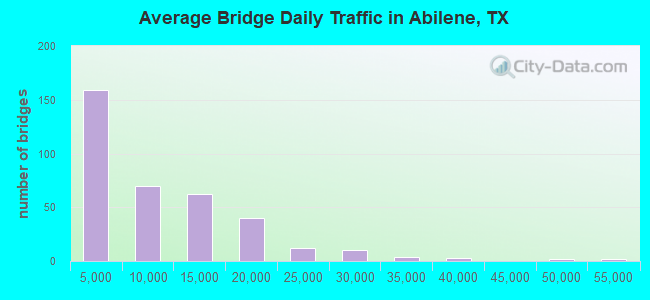
- 3,203,495Total average daily traffic
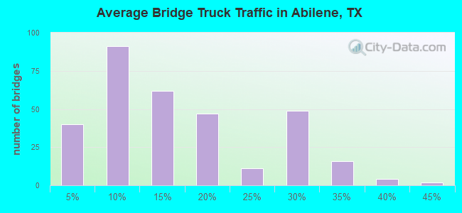
- 467,179Total average daily truck traffic
- National Bridge Inventory (NBI) Registered Bridges for Abilene
- No street view available for this location
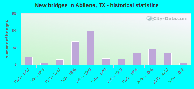
- New bridges - historical statistics
- 231920-1929
- 61930-1939
- 161940-1949
- 691950-1959
- 1001960-1969
- 181970-1979
- 171980-1989
- 351990-1999
- 462000-2009
- 342010-2019
- 62020-2022
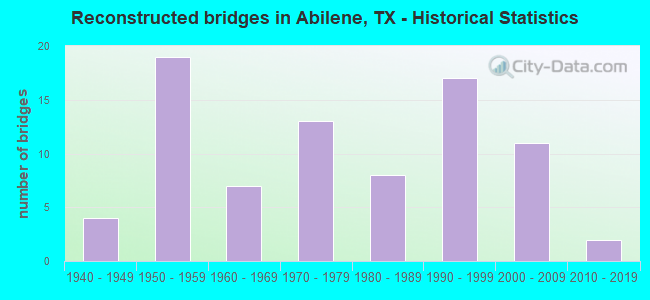
- Reconstructed bridges - Historical Statistics
- 41940-1949
- 191950-1959
- 71960-1969
- 131970-1979
- 81980-1989
- 171990-1999
- 112000-2009
- 22010-2019
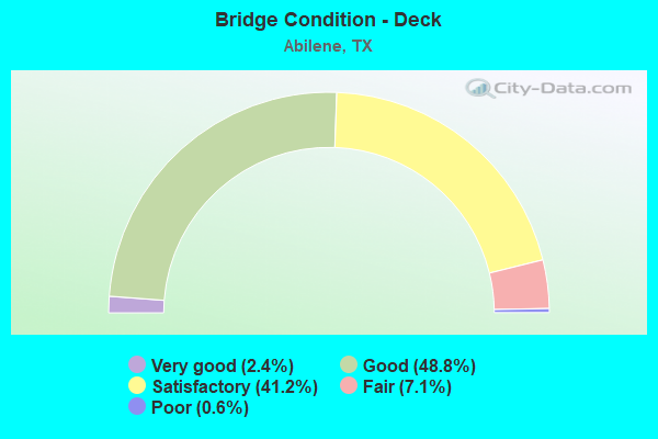
- Bridge Condition - Deck
- 2.4%Very good
- 48.8%Good
- 41.2%Satisfactory
- 7.1%Fair
- 0.6%Poor
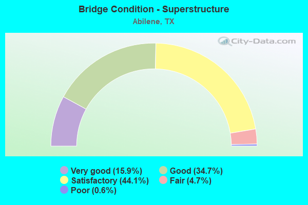
- Bridge Condition - Superstructure
- 15.9%Very good
- 34.7%Good
- 44.1%Satisfactory
- 4.7%Fair
- 0.6%Poor
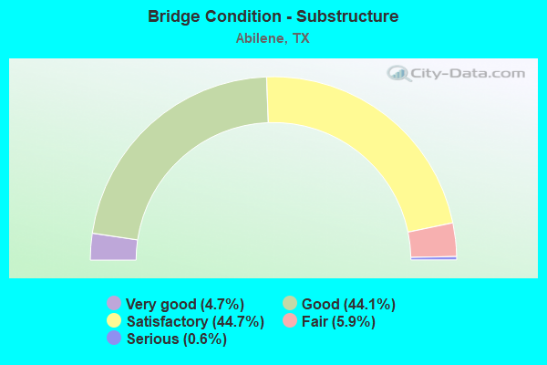
- Bridge Condition - Substructure
- 4.7%Very good
- 44.1%Good
- 44.7%Satisfactory
- 5.9%Fair
- 0.6%Serious
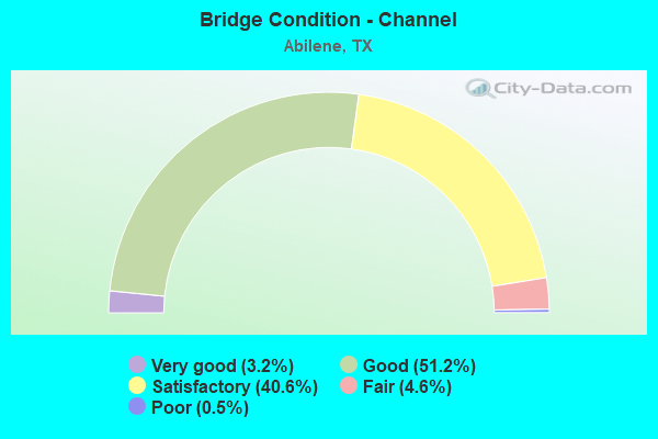
- Bridge Condition - Channel
- 3.2%Very good
- 51.2%Good
- 40.6%Satisfactory
- 4.6%Fair
- 0.5%Poor
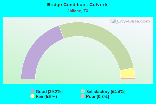
- Bridge Condition - Culverts
- 39.2%Good
- 54.4%Satisfactory
- 5.6%Fair
- 0.8%Poor
Find on map >> Show street view
Structure Number: 41880027501172, Location: 0.6 MI E of IH 27 (Lat: 35.192269, Lng: -101.827439), Route carried "under" structure: City street , Year Built: 2018, Structure Length: 0. m, Average Daily Traffic: 18,650 (year 2018), Features Intersected: IH 40, Facility Carried by Structure: IH 40 EBML
Minimum Vertical Clearance: 4.36m (14.30ft), Lanes on structure: 4, Lanes under structure: 3, Material/Design: Prestressed concrete, Design/Construction: Stringer/Multi-beam, Length of Maximum Span: 29.0m (95.1ft)
Find on map >> Show street view
Structure Number: 41880027501174, Location: 1.12 MI E of IH 27 (Lat: 35.192483, Lng: -101.817889), Route carried "under" structure: City street , Year Built: 2018, Structure Length: 0. m, Features Intersected: IH 40, Facility Carried by Structure: IH 40 EBML
Minimum Vertical Clearance: 4.42m (14.50ft), Lanes on structure: 4, Lanes under structure: 7, Material/Design: Prestressed concrete, Design/Construction: Stringer/Multi-beam, Length of Maximum Span: 30.5m (100.1ft)
Find on map >> Show street view
Structure Number: 41880027501177, Location: 1.05 MI W of Western Ave. (Lat: 35.190783, Lng: -101.902456), Route carried "under" structure: City street , Year Built: 2018, Structure Length: 0. m, Features Intersected: IH 40, Facility Carried by Structure: Bell St
Minimum Vertical Clearance: 4.80m (15.75ft), Lanes on structure: 6, Lanes under structure: 6, Material/Design: Prestressed concrete, Design/Construction: Stringer/Multi-beam, Length of Maximum Span: 21.3m (69.9ft)
Structure Number: 41880027501178, Location: IH40 - SL335 Intersection, Year Built: 2021, Structure Length: 0. m, Features Intersected: SL 335 (Lakeside Drive)
Minimum Vertical Clearance: 5.57m (18.27ft), Material/Design: Prestressed concrete, Design/Construction: Stringer/Multi-beam, Length of Maximum Span: 36.3m (119.1ft)
Minimum Vertical Clearance: 5.57m (18.27ft), Material/Design: Prestressed concrete, Design/Construction: Stringer/Multi-beam, Length of Maximum Span: 36.3m (119.1ft)
Structure Number: 4188002750118, Location: IH 40 EB AT WHITAKER RD, Route carried "under" structure: City street , Year Built: 2021, Structure Length: 0. m, Features Intersected: WHITAKER RD, Facility Carried by Structure: IH 40 EB
Minimum Vertical Clearance: 5.26m (17.26ft), Kilometerpoint: 0.000, Lanes on structure: 3, Lanes under structure: 2, Material/Design: Prestressed concrete, Design/Construction: Stringer/Multi-beam, Length of Maximum Span: 28.7m (94.2ft)
Minimum Vertical Clearance: 5.26m (17.26ft), Kilometerpoint: 0.000, Lanes on structure: 3, Lanes under structure: 2, Material/Design: Prestressed concrete, Design/Construction: Stringer/Multi-beam, Length of Maximum Span: 28.7m (94.2ft)
Find on map >> Show street view
Structure Number: 41910016809172, Location: 7 mi N. of I27 and I 40 (Lat: 35.117250, Lng: -101.909486), Route carried "under" structure: State highway 335, Year Built: 2019, Structure Length: 0. m, Features Intersected: IH27, Facility Carried by Structure: IH 27 SB
Minimum Vertical Clearance: 5.44m (17.85ft), Lanes on structure: 3, Lanes under structure: 7, Material/Design: Prestressed concrete, Design/Construction: Stringer/Multi-beam, Length of Maximum Span: 25.3m (83.0ft)
Find on map >> Show street view
Structure Number: 41910263502083, Location: .44 mi E. of IH 27 (Lat: 35.116778, Lng: -101.901400), Route carried "under" structure: City street , Year Built: 2019, Structure Length: 0. m, Average Daily Traffic: 3,000 (year 2013), Truck Traffic: 5%, Features Intersected: BELL ST, Facility Carried by Structure: SLP 335 WB
Minimum Vertical Clearance: 5.21m (17.09ft), Kilometerpoint: 5.398, Lanes on structure: 2, Lanes under structure: 8, Material/Design: Prestressed concrete, Design/Construction: Stringer/Multi-beam, Length of Maximum Span: 32.0m (105.0ft)
Find on map >> Show street view
Structure Number: 41910263502089, Location: .44 mi E. of IH 27 (Lat: 35.116703, Lng: -101.902081), Route carried "under" structure: City street , Year Built: 2019, Structure Length: 0. m, Average Daily Traffic: 3,000 (year 2013), Truck Traffic: 5%, Features Intersected: BELL ST, Facility Carried by Structure: SLP 335 EB
Minimum Vertical Clearance: 5.21m (17.09ft), Kilometerpoint: 5.398, Lanes on structure: 3, Lanes under structure: 8, Material/Design: Prestressed concrete, Design/Construction: Stringer/Multi-beam, Length of Maximum Span: 32.0m (105.0ft)
Find on map >> Show street view
Structure Number: 80300000607276, Location: 1.50 MI E OF TAYLOR C/L (Lat: 32.432211, Lng: -99.605061), Route carried "under" structure: Interstate 20, Year Built: 1964, Structure Length: 0. m, Average Daily Traffic: 23,910 (year 2013), Truck Traffic: 27%, Features Intersected: IH 20, Facility Carried by Structure: BUCK CREEK RD
Minimum Vertical Clearance: 5.16m (16.93ft), Kilometerpoint: 2.364, Lanes on structure: 2, Lanes under structure: 4, Material/Design: Concrete continuous, Design/Construction: Tee Beam, Length of Maximum Span: 21.3m (69.9ft)
Find on map >> Show street view
Structure Number: 8221000060521, Location: 1.15 MI W OF US 83 (Lat: 32.477697, Lng: -99.787153), Route carried "under" structure: City street , Year Built: 1961, Structure Length: 0. m, Average Daily Traffic: 1 (year 2009), Truck Traffic: 1%, Features Intersected: ELM CREEK & SHIRLEY RD, Facility Carried by Structure: IH 20 WB
Minimum Vertical Clearance: 4.52m (14.83ft), Kilometerpoint: 15.018, Lanes on structure: 2, Lanes under structure: 2, Material/Design: Concrete, Design/Construction: Stringer/Multi-beam, Length of Maximum Span: 12.2m (40.0ft)
Find on map >> Show street view
Structure Number: 82210000605211, Location: 1.15 MI W OF US 83 (Lat: 32.477533, Lng: -99.787072), Route carried "under" structure: City street , Year Built: 1961, Structure Length: 0. m, Average Daily Traffic: 1 (year 2009), Truck Traffic: 1%, Features Intersected: ELM CREEK & SHIRLEY RD, Facility Carried by Structure: IH 20 EB
Minimum Vertical Clearance: 4.52m (14.83ft), Kilometerpoint: 15.018, Lanes on structure: 2, Lanes under structure: 2, Material/Design: Concrete, Design/Construction: Stringer/Multi-beam, Length of Maximum Span: 12.2m (40.0ft)
Find on map >> Show street view
Structure Number: 82210000605213, Location: 2.10 MI SW OF US 83 (Lat: 32.471217, Lng: -99.805053), Route carried "under" structure: Interstate 20, Year Built: 1961, Structure Length: 0. m, Average Daily Traffic: 19,370 (year 2013), Truck Traffic: 31%, Features Intersected: IH 20, Facility Carried by Structure: FM 3438-HAYTER RD
Minimum Vertical Clearance: 5.36m (17.59ft), Kilometerpoint: 13.290, Lanes on structure: 2, Lanes under structure: 4, Material/Design: Concrete continuous, Design/Construction: Tee Beam, Length of Maximum Span: 19.8m (65.0ft)
Find on map >> Show street view
Structure Number: 82210000605216, Location: 1.10 MI E OF FM 707 (Lat: 32.466014, Lng: -99.821506), Route carried "under" structure: Interstate 20, Year Built: 1961, Structure Length: 0. m, Average Daily Traffic: 19,370 (year 2013), Truck Traffic: 31%, Features Intersected: IH 20, Facility Carried by Structure: FULWILER RD
Minimum Vertical Clearance: 5.21m (17.09ft), Kilometerpoint: 11.639, Lanes on structure: 2, Lanes under structure: 4, Material/Design: Concrete continuous, Design/Construction: Tee Beam, Length of Maximum Span: 19.8m (65.0ft)
Find on map >> Show street view
Structure Number: 82210000605324, Location: 0.25 MI W OF US 83 (Lat: 32.481350, Lng: -99.773856), Route carried "under" structure: Ramp Other road , Year Built: 2008, Structure Length: 0. m, Average Daily Traffic: 1 (year 2011), Features Intersected: IH 20 WB EXIT RAMP, Facility Carried by Structure: IH 20 EB
Minimum Vertical Clearance: 5.36m (17.59ft), Kilometerpoint: 16.439, Lanes on structure: 2, Lanes under structure: 1, Material/Design: Prestressed concrete, Design/Construction: Stringer/Multi-beam, Length of Maximum Span: 24.4m (80.1ft)
Find on map >> Show street view
Structure Number: 82210000605325, Location: 4.50 MI W OF SH 351 (Lat: 32.481936, Lng: -99.770703), Route carried "under" structure: US 83, Year Built: 2008, Structure Length: 0. m, Average Daily Traffic: 8,390 (year 2010), Truck Traffic: 20%, Features Intersected: US 83 / US 277, Facility Carried by Structure: IH 20 EB
Minimum Vertical Clearance: 5.74m (18.83ft), Kilometerpoint: 6.420, Lanes on structure: 3, Lanes under structure: 5, Material/Design: Prestressed concrete, Design/Construction: Stringer/Multi-beam, Length of Maximum Span: 30.5m (100.1ft)
Find on map >> Show street view
Structure Number: 82210000605326, Location: 4.50 MI W of SH 351 (Lat: 32.483747, Lng: -99.768828), Route carried "under" structure: US 83, Year Built: 2009, Structure Length: 0. m, Average Daily Traffic: 8,030 (year 2011), Truck Traffic: 17%, Features Intersected: US 83 / US 277, Facility Carried by Structure: IH 20 WB
Minimum Vertical Clearance: 5.23m (17.16ft), Kilometerpoint: 6.206, Lanes on structure: 2, Lanes under structure: 5, Material/Design: Prestressed concrete, Design/Construction: Stringer/Multi-beam, Length of Maximum Span: 30.5m (100.1ft)
Find on map >> Show street view
Structure Number: 82210000606185, Location: 1.65 MI SE of SH 351 (Lat: 32.461072, Lng: -99.677208), Route carried "under" structure: State highway 322, Year Built: 1961, Structure Length: 0. m, Average Daily Traffic: 9,140 (year 2013), Truck Traffic: 9%, Features Intersected: Loop 322, Facility Carried by Structure: IH 20 WB
Minimum Vertical Clearance: 4.83m (15.85ft), Kilometerpoint: 0.023, Lanes on structure: 2, Lanes under structure: 4, Material/Design: Steel continuous, Design/Construction: Stringer/Multi-beam, Length of Maximum Span: 15.2m (49.9ft)
Find on map >> Show street view
Structure Number: 82210000606186, Location: 1.65 MI SE of SH 351 (Lat: 32.460944, Lng: -99.677353), Route carried "under" structure: State highway 322, Year Built: 1961, Structure Length: 0. m, Average Daily Traffic: 9,140 (year 2013), Truck Traffic: 9%, Features Intersected: Loop 322, Facility Carried by Structure: IH 20 EB
Minimum Vertical Clearance: 4.95m (16.24ft), Kilometerpoint: 0.068, Lanes on structure: 2, Lanes under structure: 4, Material/Design: Steel continuous, Design/Construction: Stringer/Multi-beam, Length of Maximum Span: 15.2m (49.9ft)
Find on map >> Show street view
Structure Number: 82210000606194, Location: 2.30 MI E of US 83 (Lat: 32.490594, Lng: -99.731186), Route carried "under" structure: State highway 83, Year Built: 1961, Structure Length: 0. m, Average Daily Traffic: 6,010 (year 2013), Truck Traffic: 13%, Features Intersected: BUS 83 D, Facility Carried by Structure: IH 20 WB
Minimum Vertical Clearance: 6.27m (20.57ft), Kilometerpoint: 4.521, Lanes on structure: 3, Lanes under structure: 5, Material/Design: Steel continuous, Design/Construction: Stringer/Multi-beam, Length of Maximum Span: 24.4m (80.1ft)
Find on map >> Show street view
Structure Number: 82210000606195, Location: 2.30 MI E of US 83 (Lat: 32.490408, Lng: -99.731219), Route carried "under" structure: State highway 83, Year Built: 1961, Structure Length: 0. m, Average Daily Traffic: 8,220 (year 2013), Truck Traffic: 13%, Features Intersected: BUS 83 D, Facility Carried by Structure: IH 20 EB
Minimum Vertical Clearance: 6.20m (20.34ft), Kilometerpoint: 4.540, Lanes on structure: 3, Lanes under structure: 5, Material/Design: Steel continuous, Design/Construction: Stringer/Multi-beam, Length of Maximum Span: 24.4m (80.1ft)
Find on map >> Show street view
Structure Number: 82210000606196, Location: 1.85 MI E of US 83 (Lat: 32.490597, Lng: -99.739364), Route carried "under" structure: City street , Year Built: 1961, Structure Length: 0. m, Average Daily Traffic: 1 (year 2009), Features Intersected: Grape St, Facility Carried by Structure: IH 20 WB
Minimum Vertical Clearance: 5.18m (16.99ft), Lanes on structure: 2, Lanes under structure: 4, Material/Design: Steel continuous, Design/Construction: Stringer/Multi-beam, Length of Maximum Span: 18.3m (60.0ft)
Find on map >> Show street view
Structure Number: 82210000606197, Location: 1.85 MI E of US 83 (Lat: 32.490422, Lng: -99.739397), Route carried "under" structure: City street , Year Built: 1961, Structure Length: 0. m, Average Daily Traffic: 1 (year 2009), Features Intersected: Grape St, Facility Carried by Structure: IH 20 EB
Minimum Vertical Clearance: 5.18m (16.99ft), Lanes on structure: 2, Lanes under structure: 4, Material/Design: Steel continuous, Design/Construction: Stringer/Multi-beam, Length of Maximum Span: 18.3m (60.0ft)
Find on map >> Show street view
Structure Number: 82210000606198, Location: 1.45 MI W of FM 600 (Lat: 32.490461, Lng: -99.748211), Route carried "under" structure: City street , Year Built: 1961, Structure Length: 0. m, Average Daily Traffic: 1 (year 2009), Features Intersected: Old Anson Rd, Facility Carried by Structure: IH 20 WB
Minimum Vertical Clearance: 5.03m (16.50ft), Kilometerpoint: 0.000, Lanes on structure: 2, Lanes under structure: 6, Material/Design: Steel continuous, Design/Construction: Stringer/Multi-beam, Length of Maximum Span: 18.3m (60.0ft)
Find on map >> Show street view
Structure Number: 82210000606199, Location: 1.45 MI W of FM 600 (Lat: 32.490300, Lng: -99.748067), Route carried "under" structure: City street , Year Built: 1961, Structure Length: 0. m, Average Daily Traffic: 1 (year 2009), Features Intersected: Old Anson Rd, Facility Carried by Structure: IH 20 EB
Minimum Vertical Clearance: 4.72m (15.49ft), Kilometerpoint: 0.000, Lanes on structure: 2, Lanes under structure: 6, Material/Design: Steel continuous, Design/Construction: Stringer/Multi-beam, Length of Maximum Span: 18.3m (60.0ft)
Find on map >> Show street view
Structure Number: 82210000606227, Location: 0.55 MI W of Callahan C/L (Lat: 32.439094, Lng: -99.639369), Route carried "under" structure: City street , Year Built: 1961, Structure Length: 0. m, Average Daily Traffic: 1 (year 2009), Features Intersected: Elmdale Rd., Facility Carried by Structure: IH 20 WB
Minimum Vertical Clearance: 4.67m (15.32ft), Lanes on structure: 2, Lanes under structure: 2, Material/Design: Concrete continuous, Design/Construction: Slab, Length of Maximum Span: 13.7m (44.9ft)
Find on map >> Show street view
Structure Number: 82210000606228, Location: 0.55 MI W of Callahan C/L (Lat: 32.438672, Lng: -99.639503), Route carried "under" structure: City street , Year Built: 1961, Structure Length: 0. m, Average Daily Traffic: 1 (year 2009), Features Intersected: Elmdale Rd., Facility Carried by Structure: IH 20 EB
Minimum Vertical Clearance: 4.65m (15.26ft), Lanes on structure: 2, Lanes under structure: 2, Material/Design: Concrete continuous, Design/Construction: Slab, Length of Maximum Span: 13.7m (44.9ft)
Find on map >> Show street view
Structure Number: 82210000606249, Location: 2.40 MI E of US 83 (Lat: 32.490589, Lng: -99.729597), Route carried "under" structure: ServiceCity street , Year Built: 1961, Structure Length: 0. m, Average Daily Traffic: 1 (year 2009), Features Intersected: FW & D RR & Hardy St, Facility Carried by Structure: IH 20 WB
Minimum Vertical Clearance: 7.06m (23.16ft), Lanes on structure: 2, Lanes under structure: 2, Material/Design: Concrete, Design/Construction: Stringer/Multi-beam, Length of Maximum Span: 12.2m (40.0ft)
Find on map >> Show street view
Structure Number: 8221000060625, Location: 2.40 MI E OF US 83 (Lat: 32.490406, Lng: -99.729597), Route carried "under" structure: ServiceCity street , Year Built: 1961, Structure Length: 0. m, Average Daily Traffic: 1 (year 2009), Features Intersected: FW & D RR & Hardy St, Facility Carried by Structure: IH 20 EB
Minimum Vertical Clearance: 7.01m (23.00ft), Lanes on structure: 2, Lanes under structure: 2, Material/Design: Concrete, Design/Construction: Stringer/Multi-beam, Length of Maximum Span: 12.2m (40.0ft)
Find on map >> Show street view
Structure Number: 82210000606323, Location: 2.95 MI E of US 83 (Lat: 32.490381, Lng: -99.723003), Route carried "under" structure: Interstate 20, Year Built: 2003, Structure Length: 0. m, Average Daily Traffic: 22,340 (year 2013), Truck Traffic: 40%, Features Intersected: IH 20, Facility Carried by Structure: FM 600
Minimum Vertical Clearance: 5.39m (17.68ft), Kilometerpoint: 4.321, Lanes on structure: 5, Lanes under structure: 4, Material/Design: Prestressed concrete, Design/Construction: Box Beam or Girders - Multiple, Length of Maximum Span: 36.9m (121.1ft)
Find on map >> Show street view
Structure Number: 82210000606327, Location: 2.10 MI E OF LOOP 322 (Lat: 32.440589, Lng: -99.647725), Route carried "under" structure: Interstate 20, Year Built: 2003, Structure Length: 0. m, Average Daily Traffic: 21,500 (year 2009), Truck Traffic: 41%, Features Intersected: IH 20 EB & SFR
Minimum Vertical Clearance: 5.74m (18.83ft), Kilometerpoint: 13.337, Lanes on structure: 1, Lanes under structure: 4, Material/Design: Prestressed concrete, Design/Construction: Stringer/Multi-beam, Length of Maximum Span: 36.6m (120.1ft)
Find on map >> Show street view
Structure Number: 82210000606343, Location: 4.50 MI E OF US 83 (Lat: 32.477500, Lng: -99.700000), Route carried "under" structure: State highway 351, Year Built: 2017, Structure Length: 0. m, Average Daily Traffic: 13,250 (year 2013), Truck Traffic: 27%, Features Intersected: SH 351, Facility Carried by Structure: IH 20 EB
Minimum Vertical Clearance: 5.58m (18.31ft), Kilometerpoint: 6.946, Material/Design: Prestressed concrete, Design/Construction: Stringer/Multi-beam, Length of Maximum Span: 21.3m (69.9ft)
Find on map >> Show street view
Structure Number: 82210000606344, Location: 4.5 MI E OF US 83 (Lat: 32.477200, Lng: -99.699400), Route carried "under" structure: State highway 351, Year Built: 2017, Structure Length: 0. m, Average Daily Traffic: 13,250 (year 2013), Truck Traffic: 27%, Features Intersected: SH 351, Facility Carried by Structure: IH 20 WB
Minimum Vertical Clearance: 5.41m (17.75ft), Kilometerpoint: 6.946, Material/Design: Prestressed concrete, Design/Construction: Stringer/Multi-beam, Length of Maximum Span: 21.3m (69.9ft)
Find on map >> Show street view
Structure Number: 82210000618225, Location: 1.70 MI E OF US 83 (Lat: 32.450453, Lng: -99.758064), Route carried "under" structure: City street , Year Built: 1959, Structure Length: 0. m, Average Daily Traffic: 1 (year 2009), Truck Traffic: 1%, Features Intersected: MOCKINGBIRD LN, Facility Carried by Structure: LOOP 20 BUS
Minimum Vertical Clearance: 4.52m (14.83ft), Lanes on structure: 5, Lanes under structure: 4, Material/Design: Concrete continuous, Design/Construction: Slab, Length of Maximum Span: 10.1m (33.1ft)
Structure Number: 82210000618243, Location: 3.15 MI E OF US 83, Route carried "under" structure: City street , Year Built: 1960, Structure Length: 0. m, Average Daily Traffic: 1 (year 2009), Truck Traffic: 11%, Features Intersected: PINE ST, Facility Carried by Structure: BUS LOOP 20 (R)
Minimum Vertical Clearance: 4.22m (13.85ft), Kilometerpoint: 0.000, Lanes on structure: 4, Lanes under structure: 4, Material/Design: Concrete continuous, Design/Construction: Slab, Length of Maximum Span: 9.1m (29.9ft)
Minimum Vertical Clearance: 4.22m (13.85ft), Kilometerpoint: 0.000, Lanes on structure: 4, Lanes under structure: 4, Material/Design: Concrete continuous, Design/Construction: Slab, Length of Maximum Span: 9.1m (29.9ft)
Find on map >> Show street view
Structure Number: 82210000618329, Location: INTERSECT FM 3438 & US 84 (Lat: 32.452875, Lng: -99.808297), Route carried "under" structure: US 84, Year Built: 2010, Structure Length: 0. m, Average Daily Traffic: 19,000 (year 2011), Truck Traffic: 20%, Features Intersected: US84/IH20BUS/LittleElmCB, Facility Carried by Structure: FM 3438
Minimum Vertical Clearance: 7.32m (24.02ft), Kilometerpoint: 0.000, Lanes on structure: 2, Lanes under structure: 6, Material/Design: Prestressed concrete, Design/Construction: Stringer/Multi-beam, Length of Maximum Span: 39.6m (129.9ft)
Find on map >> Show street view
Structure Number: 82210000618341, Location: 0.30 MILE EAST OF IH 20 (Lat: 32.456772, Lng: -99.842428), Route carried "under" structure: City street , Year Built: 2015, Structure Length: 0. m, Average Daily Traffic: 45 (year 2020), Truck Traffic: 4%, Features Intersected: UPRR & OLD HWY 80, Facility Carried by Structure: US 84
Minimum Vertical Clearance: 4.83m (15.85ft), Kilometerpoint: 0.161, Lanes on structure: 4, Lanes under structure: 2, Material/Design: Prestressed concrete, Design/Construction: Stringer/Multi-beam, Length of Maximum Span: 41.8m (137.1ft)
Find on map >> Show street view
Structure Number: 82210003306072, Location: 1.65 MI S OF IH 20 (Lat: 32.462097, Lng: -99.784267), Route carried "under" structure: City street , Year Built: 1964, Structure Length: 0. m, Average Daily Traffic: 1 (year 2009), Features Intersected: N 10th St, Facility Carried by Structure: US 83 NB
Minimum Vertical Clearance: 4.40m (14.44ft), Kilometerpoint: 0.000, Lanes on structure: 2, Lanes under structure: 5, Material/Design: Steel continuous, Design/Construction: Stringer/Multi-beam, Length of Maximum Span: 24.4m (80.1ft)
Find on map >> Show street view
Structure Number: 82210003306073, Location: 1.65 MI S OF IH 20 (Lat: 32.462044, Lng: -99.784517), Route carried "under" structure: City street , Year Built: 1964, Structure Length: 0. m, Average Daily Traffic: 1 (year 2009), Features Intersected: N 10th St, Facility Carried by Structure: US 83 SB
Minimum Vertical Clearance: 4.40m (14.44ft), Kilometerpoint: 0.000, Lanes on structure: 2, Lanes under structure: 5, Material/Design: Steel continuous, Design/Construction: Stringer/Multi-beam, Length of Maximum Span: 24.4m (80.1ft)
Structure Number: 82210003306074, Location: 3.00 MI S OF IH 20, Route carried "under" structure: City street , Year Built: 1964, Structure Length: 0. m, Average Daily Traffic: 1 (year 2009), Features Intersected: SOUTH 7TH ST, Facility Carried by Structure: US 83 NB
Minimum Vertical Clearance: 4.50m (14.76ft), Material/Design: Steel continuous, Design/Construction: Stringer/Multi-beam, Length of Maximum Span: 22.9m (75.1ft)
Minimum Vertical Clearance: 4.50m (14.76ft), Material/Design: Steel continuous, Design/Construction: Stringer/Multi-beam, Length of Maximum Span: 22.9m (75.1ft)
Find on map >> Show street view
Structure Number: 82210003306075, Location: 3.00 MI S OF IH 20 (Lat: 32.443875, Lng: -99.786953), Route carried "under" structure: City street , Year Built: 1964, Structure Length: 0. m, Average Daily Traffic: 1 (year 2009), Features Intersected: SOUTH 7TH ST, Facility Carried by Structure: US 83 SB
Minimum Vertical Clearance: 4.50m (14.76ft), Kilometerpoint: 11.030, Lanes on structure: 2, Lanes under structure: 6, Material/Design: Steel continuous, Design/Construction: Stringer/Multi-beam, Length of Maximum Span: 22.9m (75.1ft)
Find on map >> Show street view
Structure Number: 82210003306077, Location: 1.50 MI NE of IH 20 (Lat: 32.501567, Lng: -99.755869), Route carried "under" structure: State highway 2404, Year Built: 1970, Structure Length: 0. m, Average Daily Traffic: 1,410 (year 2013), Truck Traffic: 20%, Features Intersected: FM 2404, Facility Carried by Structure: US 83 NB/US 277 NB
Minimum Vertical Clearance: 4.90m (16.08ft), Kilometerpoint: 6.204, Lanes on structure: 2, Lanes under structure: 4, Material/Design: Prestressed concrete, Design/Construction: Stringer/Multi-beam, Length of Maximum Span: 25.9m (85.0ft)
Find on map >> Show street view
Structure Number: 82210003306078, Location: 1.35 MI S of Jones C/L (Lat: 32.501592, Lng: -99.756083), Route carried "under" structure: State highway 2404, Year Built: 1970, Structure Length: 0. m, Average Daily Traffic: 1,410 (year 2013), Truck Traffic: 20%, Features Intersected: FM 2404, Facility Carried by Structure: US 83 SB/US 277 SB
Minimum Vertical Clearance: 4.70m (15.42ft), Kilometerpoint: 6.185, Lanes on structure: 2, Lanes under structure: 4, Material/Design: Prestressed concrete, Design/Construction: Stringer/Multi-beam, Length of Maximum Span: 25.9m (85.0ft)
Find on map >> Show street view
Structure Number: 82210003306079, Location: 0.55 MI SW OF IH 20 (Lat: 32.475253, Lng: -99.775261), Route carried "under" structure: City street , Year Built: 1970, Structure Length: 0. m, Average Daily Traffic: 1 (year 2009), Features Intersected: Ambler Ave, Facility Carried by Structure: US 83 NB
Minimum Vertical Clearance: 4.75m (15.58ft), Kilometerpoint: 7.289, Lanes on structure: 2, Lanes under structure: 4, Material/Design: Prestressed concrete, Design/Construction: Stringer/Multi-beam, Length of Maximum Span: 27.4m (89.9ft)
Find on map >> Show street view
Structure Number: 8221000330608, Location: 0.55 MI SW OF IH 20 (Lat: 32.475347, Lng: -99.775442), Route carried "under" structure: City street , Year Built: 1970, Structure Length: 0. m, Average Daily Traffic: 1 (year 2009), Features Intersected: Ambler Ave, Facility Carried by Structure: US 83 SB
Minimum Vertical Clearance: 4.83m (15.85ft), Kilometerpoint: 7.289, Lanes on structure: 3, Lanes under structure: 4, Material/Design: Prestressed concrete, Design/Construction: Stringer/Multi-beam, Length of Maximum Span: 27.4m (89.9ft)
Find on map >> Show street view
Structure Number: 82210003306088, Location: 0.35 MI S of Jones C/L (Lat: 32.516053, Lng: -99.750872), Route carried "under" structure: State highway 83, Year Built: 1996, Structure Length: 0. m, Average Daily Traffic: 5,810 (year 2013), Truck Traffic: 7%, Features Intersected: BUS 83 SB
Minimum Vertical Clearance: 5.41m (17.75ft), Kilometerpoint: 2.195, Lanes on structure: 2, Lanes under structure: 2, Material/Design: Prestressed concrete, Design/Construction: Stringer/Multi-beam, Length of Maximum Span: 27.4m (89.9ft)
Find on map >> Show street view
Structure Number: 82210003306089, Location: 1.8 Mi S of BI 20 (Lat: 32.426819, Lng: -99.785833), Route carried "under" structure: US 277, Year Built: 2000, Structure Length: 0. m, Average Daily Traffic: 18,080 (year 2013), Truck Traffic: 14%, Features Intersected: US 277 (S 14th St), Facility Carried by Structure: US 83 / US 84 NB
Minimum Vertical Clearance: 5.21m (17.09ft), Kilometerpoint: 1.696, Lanes on structure: 3, Lanes under structure: 6, Material/Design: Prestressed concrete, Design/Construction: Stringer/Multi-beam, Length of Maximum Span: 27.4m (89.9ft)
Find on map >> Show street view
Structure Number: 8221000330609, Location: 1.8 Mi S of BI 20 (Lat: 32.426444, Lng: -99.785819), Route carried "under" structure: US 277, Year Built: 2000, Structure Length: 0. m, Average Daily Traffic: 18,080 (year 2013), Truck Traffic: 14%, Features Intersected: US 277 (S 14th St), Facility Carried by Structure: US 83 / US 84 SB
Minimum Vertical Clearance: 5.21m (17.09ft), Kilometerpoint: 1.696, Lanes on structure: 3, Lanes under structure: 6, Material/Design: Prestressed concrete, Design/Construction: Stringer/Multi-beam, Length of Maximum Span: 27.4m (89.9ft)
Find on map >> Show street view
Structure Number: 82210003306313, Location: 2.30 MI S OF IH 20 (Lat: 32.452625, Lng: -99.786114), Route carried "under" structure: US 84, Year Built: 1957, Structure Length: 0. m, Average Daily Traffic: 16,990 (year 2013), Truck Traffic: 12%, Features Intersected: US 84/ UPRR/ 1ST St, Facility Carried by Structure: US 83 SB
Minimum Vertical Clearance: 7.32m (24.02ft), Kilometerpoint: 6.252, Lanes on structure: 3, Lanes under structure: 11, Material/Design: Steel continuous, Design/Construction: Stringer/Multi-beam, Length of Maximum Span: 25.9m (85.0ft)
Find on map >> Show street view
Structure Number: 82210003306314, Location: 2.30 MI S OF IH 20 (Lat: 32.452739, Lng: -99.785992), Route carried "under" structure: US 84, Year Built: 1957, Structure Length: 0. m, Average Daily Traffic: 18,990 (year 2009), Truck Traffic: 9%, Features Intersected: US 84 / UPRR / 1st ST, Facility Carried by Structure: US 83 NB
Minimum Vertical Clearance: 7.32m (24.02ft), Kilometerpoint: 6.252, Lanes on structure: 3, Lanes under structure: 11, Material/Design: Steel continuous, Design/Construction: Stringer/Multi-beam, Length of Maximum Span: 25.9m (85.0ft)
Find on map >> Show street view
Structure Number: 82210003401056, Location: 1.00 MI S OF LP 322 (Lat: 32.372867, Lng: -99.741936), Route carried "under" structure: City street , Year Built: 1994, Structure Length: 0. m, Average Daily Traffic: 1 (year 2009), Features Intersected: Antillet Rd, Facility Carried by Structure: US 83 NB
Minimum Vertical Clearance: 5.82m (19.09ft), Kilometerpoint: 9.992, Lanes on structure: 2, Lanes under structure: 6, Material/Design: Prestressed concrete, Design/Construction: Stringer/Multi-beam, Length of Maximum Span: 25.9m (85.0ft)
Find on map >> Show street view
Structure Number: 82210003401057, Location: 1.00 MI S OF LP 322 (Lat: 32.372869, Lng: -99.742058), Route carried "under" structure: City street , Year Built: 1994, Structure Length: 0. m, Average Daily Traffic: 1 (year 2009), Features Intersected: Antilley Rd, Facility Carried by Structure: US 83 SB
Minimum Vertical Clearance: 5.66m (18.57ft), Kilometerpoint: 9.992, Lanes on structure: 2, Lanes under structure: 6, Material/Design: Prestressed concrete, Design/Construction: Stringer/Multi-beam, Length of Maximum Span: 25.9m (85.0ft)
Find on map >> Show street view
Structure Number: 82210003401059, Location: 2.40 MI SE OF US 277 (Lat: 32.401364, Lng: -99.758222), Route carried "under" structure: State highway 89, Year Built: 2000, Structure Length: 0. m, Average Daily Traffic: 33,000 (year 2010), Truck Traffic: 6%, Features Intersected: FM 89, Facility Carried by Structure: US 83/US 84 NB
Minimum Vertical Clearance: 4.83m (15.85ft), Kilometerpoint: 34.582, Lanes on structure: 3, Lanes under structure: 9, Material/Design: Steel continuous, Design/Construction: Stringer/Multi-beam, Length of Maximum Span: 27.4m (89.9ft)
Find on map >> Show street view
Structure Number: 82210003401061, Location: 2.40 MI S OF LOOP 322 (Lat: 32.351775, Lng: -99.742275), Route carried "under" structure: State highway 707, Year Built: 2002, Structure Length: 0. m, Average Daily Traffic: 2,100 (year 2010), Truck Traffic: 6%, Features Intersected: FM 707, Facility Carried by Structure: US 83 / US 84
Minimum Vertical Clearance: 5.49m (18.01ft), Kilometerpoint: 7.049, Lanes on structure: 4, Lanes under structure: 5, Material/Design: Prestressed concrete, Design/Construction: Stringer/Multi-beam, Length of Maximum Span: 25.9m (85.0ft)
Find on map >> Show street view
Structure Number: 82210003401064, Location: 1.10 MI SE OF US 277 (Lat: 32.412847, Lng: -99.775067), Route carried "under" structure: City street , Year Built: 2003, Structure Length: 0. m, Average Daily Traffic: 1 (year 2009), Features Intersected: Southwest Dr, Facility Carried by Structure: US 83 /US 84 NB
Minimum Vertical Clearance: 5.18m (16.99ft), Kilometerpoint: 4.271, Lanes on structure: 3, Lanes under structure: 8, Material/Design: Prestressed concrete, Design/Construction: Stringer/Multi-beam, Length of Maximum Span: 27.4m (89.9ft)
Find on map >> Show street view
Structure Number: 82210003401065, Location: 1.10 MI SE OF US 277 (Lat: 32.412753, Lng: -99.774839), Route carried "under" structure: City street , Year Built: 2003, Structure Length: 0. m, Average Daily Traffic: 1 (year 2013), Features Intersected: Southwest Dr, Facility Carried by Structure: US 83 / US 84 SB
Minimum Vertical Clearance: 5.21m (17.09ft), Kilometerpoint: 4.271, Lanes on structure: 3, Lanes under structure: 8, Material/Design: Prestressed concrete, Design/Construction: Stringer/Multi-beam, Length of Maximum Span: 27.4m (89.9ft)
Find on map >> Show street view
Structure Number: 82210003401087, Location: 2.45 MI N OF FM 707 (Lat: 32.388056, Lng: -99.744733), Route carried "under" structure: US 83, Year Built: 1994, Structure Length: 0. m, Average Daily Traffic: 17,508 (year 2010), Truck Traffic: 6%, Features Intersected: US 83 / US 84, Facility Carried by Structure: LOOP 322 EB CONN
Minimum Vertical Clearance: 30+ m (98+ ft), Kilometerpoint: 1.979, Lanes on structure: 1, Lanes under structure: 4, Material/Design: Prestressed concrete, Design/Construction: Stringer/Multi-beam, Length of Maximum Span: 36.6m (120.1ft)
Find on map >> Show street view
Structure Number: 82210003401088, Location: 2.20 MI N OF FM 707 (Lat: 32.384544, Lng: -99.742631), Route carried "under" structure: US 83, Year Built: 1994, Structure Length: 0. m, Average Daily Traffic: 17,508 (year 2010), Truck Traffic: 6%, Features Intersected: US 83 / US 84
Minimum Vertical Clearance: 5.26m (17.26ft), Kilometerpoint: 2.028, Lanes on structure: 2, Lanes under structure: 4, Material/Design: Prestressed concrete, Design/Construction: Stringer/Multi-beam, Length of Maximum Span: 33.5m (109.9ft)
Find on map >> Show street view
Structure Number: 8221000340109, Location: 2.4 MI SE OF US 277 (Lat: 32.401556, Lng: -99.758528), Route carried "under" structure: State highway 89, Year Built: 2000, Structure Length: 0. m, Average Daily Traffic: 33,000 (year 2010), Truck Traffic: 6%, Features Intersected: FM 89, Facility Carried by Structure: US 83/US 84 SB
Minimum Vertical Clearance: 4.83m (15.85ft), Kilometerpoint: 34.582, Lanes on structure: 3, Lanes under structure: 6, Material/Design: Steel continuous, Design/Construction: Stringer/Multi-beam, Length of Maximum Span: 27.4m (89.9ft)
Find on map >> Show street view
Structure Number: 82210018101025, Location: 1.95 MI S OF IH 20 (Lat: 32.434925, Lng: -99.687306), Route carried "under" structure: State highway 36, Year Built: 1969, Structure Length: 0. m, Average Daily Traffic: 7,850 (year 2013), Truck Traffic: 25%, Features Intersected: SH 36, Facility Carried by Structure: LOOP 322 SB
Minimum Vertical Clearance: 5.39m (17.68ft), Kilometerpoint: 11.980, Lanes on structure: 2, Lanes under structure: 6, Material/Design: Steel continuous, Design/Construction: Stringer/Multi-beam, Length of Maximum Span: 24.4m (80.1ft)
Find on map >> Show street view
Structure Number: 82210040706001, Location: 1.80 MI SW OF US 83/84 (Lat: 32.405914, Lng: -99.805075), Route carried "under" structure: US 277, Year Built: 1995, Structure Length: 0. m, Average Daily Traffic: 6,700 (year 2010), Truck Traffic: 21%, Features Intersected: US 277, Facility Carried by Structure: FM 3438
Minimum Vertical Clearance: 5.41m (17.75ft), Kilometerpoint: 5.441, Lanes on structure: 4, Lanes under structure: 6, Material/Design: Prestressed concrete, Design/Construction: Stringer/Multi-beam, Length of Maximum Span: 30.5m (100.1ft)
Find on map >> Show street view
Structure Number: 8221023980101, Location: 4.05 MI SW OF IH 20 (Lat: 32.411481, Lng: -99.708050), Route carried "under" structure: State highway 1750, Year Built: 1970, Structure Length: 0. m, Average Daily Traffic: 5,110 (year 2013), Truck Traffic: 12%, Features Intersected: FM 1750, Facility Carried by Structure: LOOP 322 SB
Minimum Vertical Clearance: 4.85m (15.91ft), Kilometerpoint: 4.506, Lanes on structure: 2, Lanes under structure: 5, Material/Design: Prestressed concrete, Design/Construction: Stringer/Multi-beam, Length of Maximum Span: 36.6m (120.1ft)
Find on map >> Show street view
Structure Number: 82210239801011, Location: 4.85 MI S OF IH 20 (Lat: 32.401519, Lng: -99.716050), Route carried "under" structure: City street , Year Built: 1970, Structure Length: 0. m, Average Daily Traffic: 1 (year 2009), Features Intersected: Industrial Blvd, Facility Carried by Structure: LOOP 322 SB
Minimum Vertical Clearance: 4.85m (15.91ft), Kilometerpoint: 7.897, Lanes on structure: 2, Lanes under structure: 6, Material/Design: Prestressed concrete, Design/Construction: Stringer/Multi-beam, Length of Maximum Span: 34.1m (111.9ft)
Find on map >> Show street view
Structure Number: 82210239801012, Location: 5.80 MI S OF IH 20 (Lat: 32.390747, Lng: -99.725269), Route carried "under" structure: State highway 322, Year Built: 1970, Structure Length: 0. m, Average Daily Traffic: 14,180 (year 2013), Truck Traffic: 18%, Features Intersected: Loop 322, Facility Carried by Structure: MAPLE ST
Minimum Vertical Clearance: 5.28m (17.32ft), Kilometerpoint: 9.476, Lanes on structure: 2, Lanes under structure: 4, Material/Design: Prestressed concrete, Design/Construction: Stringer/Multi-beam, Length of Maximum Span: 27.4m (89.9ft)
Find on map >> Show street view
Structure Number: 82210239801015, Location: 4.05 MI S OF IH 20 (Lat: 32.411244, Lng: -99.708119), Route carried "under" structure: State highway 1750, Year Built: 1997, Structure Length: 0. m, Average Daily Traffic: 5,680 (year 2013), Truck Traffic: 11%, Features Intersected: FM 1750, Facility Carried by Structure: LOOP 322 NB
Minimum Vertical Clearance: 5.28m (17.32ft), Kilometerpoint: 4.525, Lanes on structure: 2, Lanes under structure: 5, Material/Design: Prestressed concrete, Design/Construction: Stringer/Multi-beam, Length of Maximum Span: 36.6m (120.1ft)
Find on map >> Show street view
Structure Number: 82210239801016, Location: 4.85 MI S OF IH 20 (Lat: 32.401567, Lng: -99.715797), Route carried "under" structure: City street , Year Built: 1997, Structure Length: 0. m, Average Daily Traffic: 1 (year 2009), Features Intersected: Industrial, Facility Carried by Structure: LOOP 322 NB
Minimum Vertical Clearance: 5.23m (17.16ft), Kilometerpoint: 7.897, Lanes on structure: 2, Lanes under structure: 6, Material/Design: Prestressed concrete, Design/Construction: Stringer/Multi-beam, Length of Maximum Span: 34.1m (111.9ft)
Structure Number: 82210239801027, Location: 1.95 MI S OF IH 20, Route carried "under" structure: State highway 36, Year Built: 2000, Structure Length: 0. m, Average Daily Traffic: 1 (year 2009), Features Intersected: SH 36, Facility Carried by Structure: LOOP 322 NB
Minimum Vertical Clearance: 5.44m (17.85ft), Kilometerpoint: 3.174, Lanes on structure: 2, Lanes under structure: 6, Material/Design: Prestressed concrete, Design/Construction: Stringer/Multi-beam, Length of Maximum Span: 24.4m (80.1ft)
Minimum Vertical Clearance: 5.44m (17.85ft), Kilometerpoint: 3.174, Lanes on structure: 2, Lanes under structure: 6, Material/Design: Prestressed concrete, Design/Construction: Stringer/Multi-beam, Length of Maximum Span: 24.4m (80.1ft)
Find on map >> Show street view
Structure Number: 82210239801085, Location: 6.90 MI SW OF IH 20 (Lat: 32.387389, Lng: -99.741481), Route carried "under" structure: State highway 83, Year Built: 1994, Structure Length: 0. m, Average Daily Traffic: 12,100 (year 2010), Truck Traffic: 5%, Features Intersected: US 83 BUS, Facility Carried by Structure: LOOP 322 WB CONN
Minimum Vertical Clearance: 5.84m (19.16ft), Kilometerpoint: 17.896, Lanes on structure: 2, Lanes under structure: 4, Material/Design: Prestressed concrete, Design/Construction: Stringer/Multi-beam, Length of Maximum Span: 33.5m (109.9ft)
Find on map >> Show street view
Structure Number: 82210239801086, Location: 6.90 MI SW OF IH 20 (Lat: 32.387111, Lng: -99.742306), Route carried "under" structure: State highway 83, Year Built: 1994, Structure Length: 0. m, Average Daily Traffic: 12,100 (year 2010), Truck Traffic: 5%, Features Intersected: US 83 BUS, Facility Carried by Structure: LOOP 322 EB CONN
Minimum Vertical Clearance: 5.56m (18.24ft), Kilometerpoint: 17.976, Lanes on structure: 2, Lanes under structure: 4, Material/Design: Prestressed concrete, Design/Construction: Stringer/Multi-beam, Length of Maximum Span: 33.5m (109.9ft)
Find on map >> Show street view
Structure Number: 82210239801321, Location: 1.10 MI S OF IH 20 (Lat: 32.446375, Lng: -99.683383), Route carried "under" structure: Business State highway 20, Year Built: 2003, Structure Length: 0. m, Average Daily Traffic: 10,760 (year 2009), Truck Traffic: 10%, Features Intersected: BUS LOOP 20 R, Facility Carried by Structure: LOOP 322 SB
Minimum Vertical Clearance: 5.59m (18.34ft), Kilometerpoint: 1.844, Lanes on structure: 2, Lanes under structure: 4, Material/Design: Prestressed concrete, Design/Construction: Stringer/Multi-beam, Length of Maximum Span: 30.5m (100.1ft)
Find on map >> Show street view
Structure Number: 82210239801322, Location: 1.10 MI S OF IH 20 (Lat: 32.446372, Lng: -99.683225), Route carried "under" structure: Business State highway 20, Year Built: 2003, Structure Length: 0. m, Average Daily Traffic: 10,800 (year 2009), Truck Traffic: 6%, Features Intersected: BUS LOOP 20 R, Facility Carried by Structure: LOOP 322 NB
Minimum Vertical Clearance: 5.69m (18.67ft), Kilometerpoint: 1.849, Lanes on structure: 2, Lanes under structure: 4, Material/Design: Prestressed concrete, Design/Construction: Stringer/Multi-beam, Length of Maximum Span: 30.5m (100.1ft)
Find on map >> Show street view
Structure Number: 82210B13134005, Location: 0.05 MI N OF BUS LOOP 20 (Lat: 32.451072, Lng: -99.757894), Route carried "under" structure: City street , Year Built: 1959, Structure Length: 0. m, Average Daily Traffic: 11,260 (year 2020), Truck Traffic: 3%, Features Intersected: None, Facility Carried by Structure: NORTH 1st St
Minimum Vertical Clearance: 4.14m (13.58ft), Kilometerpoint: 3.970, Material/Design: Concrete continuous, Design/Construction: Slab, Length of Maximum Span: 9.8m (32.2ft)