Bridge Statistics for Abilene, Texas (TX)
Condition, Traffic, Stress, Structural Evaluation, Project Costs
- National Bridge Inventory (NBI) Statistics
- 370Number of bridges
- 4,403ft / 1,342mTotal length
- $4,736,000Total costs
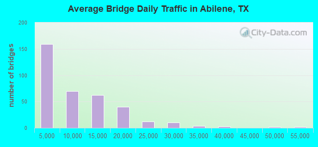
- 3,203,495Total average daily traffic
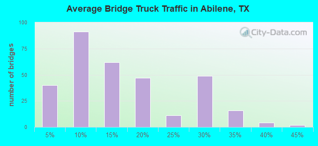
- 467,179Total average daily truck traffic
- National Bridge Inventory (NBI) Registered Bridges for Abilene
- No street view available for this location
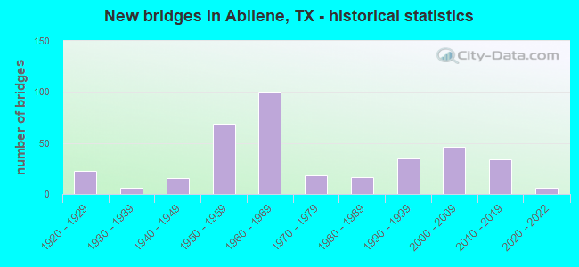
- New bridges - historical statistics
- 231920-1929
- 61930-1939
- 161940-1949
- 691950-1959
- 1001960-1969
- 181970-1979
- 171980-1989
- 351990-1999
- 462000-2009
- 342010-2019
- 62020-2022
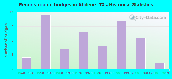
- Reconstructed bridges - Historical Statistics
- 41940-1949
- 191950-1959
- 71960-1969
- 131970-1979
- 81980-1989
- 171990-1999
- 112000-2009
- 22010-2019
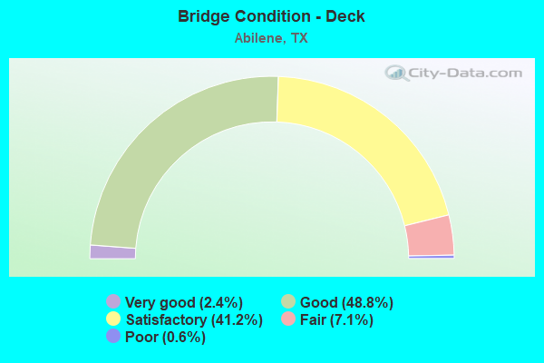
- Bridge Condition - Deck
- 2.4%Very good
- 48.8%Good
- 41.2%Satisfactory
- 7.1%Fair
- 0.6%Poor
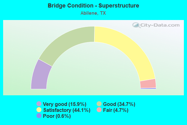
- Bridge Condition - Superstructure
- 15.9%Very good
- 34.7%Good
- 44.1%Satisfactory
- 4.7%Fair
- 0.6%Poor
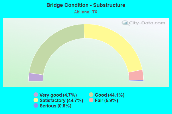
- Bridge Condition - Substructure
- 4.7%Very good
- 44.1%Good
- 44.7%Satisfactory
- 5.9%Fair
- 0.6%Serious
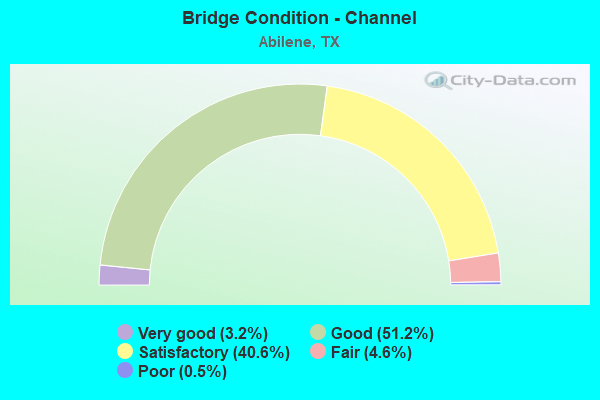
- Bridge Condition - Channel
- 3.2%Very good
- 51.2%Good
- 40.6%Satisfactory
- 4.6%Fair
- 0.5%Poor
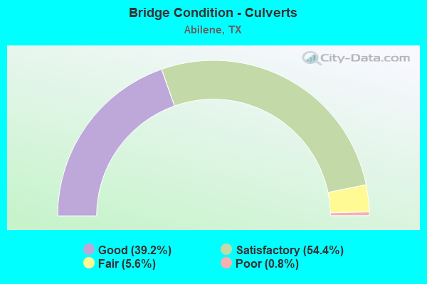
- Bridge Condition - Culverts
- 39.2%Good
- 54.4%Satisfactory
- 5.6%Fair
- 0.8%Poor
Find on map >> Show street view
Structure Number: 8221000340106, Location: 0.05 MI N OF FM 707 (Lat: 32.352669, Lng: -99.742600), Route carried "on" structure: US 83, Year Built: 2002, Status: Open, Structure Length: 0.82m (2.69ft), Average Daily Traffic: 15,727 (year 2019), Truck Traffic: 7%, Average Future Daily Traffic: 33,950 (year 2029), Design Load: HS 20, Features Intersected: DRAW
Minimum Vertical Clearance: 30+ m (98+ ft), Kilometerpoint: 6.272, Lanes on structure: 8, Owner: State Highway Agency, Approaching Roadway Width: 42.7m (140.1ft), Material/Design: Concrete, Design/Construction: Culvert, Number Of Spans In Main Unit: 5, Length of Maximum Span: 1.5m (4.9ft)
Condition: Channel: Satisfactory, Culverts: Good, Operating Rating: 44.4 metric tons, Method Used To Determine Operating Rating: Assigned rating based on Load Factor Design (LFD) reported in metric tons, Inventory Rating: 32.7 metric tons, Method Used To Determine Inventory Rating: Assigned rating based on Load Factor Design (LFD) reported in metric tons, Structural Evaluation: Better than present minimum criteria, Waterway Adequacy: Better than present minimum criteria, Approach Roadway Alignment: Equal to present desirable criteria, Designated Inspection Frequency: Every 48 months, Inspection Date: July 2019
Find on map >> Show street view
Structure Number: 82210003401061, Location: 2.40 MI S OF LOOP 322 (Lat: 32.351775, Lng: -99.742275), Route carried "on" structure: US 83, Year Built: 2002, Status: Open, Structure Length: 7.19m (23.59ft), Average Daily Traffic: 15,727 (year 2019), Truck Traffic: 13%, Average Future Daily Traffic: 17,700 (year 2033), Design Load: HS 20, Features Intersected: FM 707
Minimum Vertical Clearance: 30+ m (98+ ft), Kilometerpoint: 12.369, Lanes on structure: 4, Lanes under structure: 5, Owner: State Highway Agency, Approaching Roadway Width: 22.6m (74.1ft), Skew: 30 degrees, Material/Design: Prestressed concrete, Design/Construction: Stringer/Multi-beam, Number Of Spans In Main Unit: 3, Length of Maximum Span: 25.9m (85.0ft), Curb-To-Curb Width: 22.7m (74.5ft), Out-to-Out Width: 24.1m (79.1ft)
Condition: Deck: Satisfactory, Superstructure: Good, Substructure: Satisfactory, Operating Rating: 54.4 metric tons, Method Used To Determine Operating Rating: Assigned rating based on Load Factor Design (LFD) reported in metric tons, Inventory Rating: 32.7 metric tons, Method Used To Determine Inventory Rating: Assigned rating based on Load Factor Design (LFD) reported in metric tons, Structural Evaluation: Equal to present minimum criteria, Deck Geometry: Superior to present desirable criteria, Underclear: Equal to present minimum criteria, Approach Roadway Alignment: Equal to present desirable criteria, Designated Inspection Frequency: Every 24 months, Inspection Date: July 2021, Deck Structure Type: Concrete Precast Panels
Find on map >> Show street view
Structure Number: 82210003401062, Location: 0.40 MI S OF US 277 (Lat: 32.421461, Lng: -99.783044), Route carried "on" structure: US 83, Year Built: 2002, Status: Open, Structure Length: 4.88m (16.01ft), Average Daily Traffic: 16,331 (year 2020), Truck Traffic: 7%, Average Future Daily Traffic: 8,370 (year 2030), Design Load: HS 20, Features Intersected: ELM CREEK
Minimum Vertical Clearance: 30+ m (98+ ft), Kilometerpoint: 3.013, Lanes on structure: 3, Owner: State Highway Agency, Approaching Roadway Width: 17.1m (56.1ft), Material/Design: Prestressed concrete, Design/Construction: Stringer/Multi-beam, Number Of Spans In Main Unit: 4, Length of Maximum Span: 12.2m (40.0ft), Curb-To-Curb Width: 17.0m (55.8ft), Out-to-Out Width: 17.7m (58.1ft)
Condition: Deck: Good, Superstructure: Very good, Substructure: Satisfactory, Channel: Satisfactory, Operating Rating: 54.4 metric tons, Method Used To Determine Operating Rating: Assigned rating based on Load Factor Design (LFD) reported in metric tons, Inventory Rating: 32.7 metric tons, Method Used To Determine Inventory Rating: Assigned rating based on Load Factor Design (LFD) reported in metric tons, Structural Evaluation: Equal to present minimum criteria, Deck Geometry: Equal to present minimum criteria, Waterway Adequacy: Superior to present desirable criteria, Approach Roadway Alignment: Equal to present desirable criteria, Designated Inspection Frequency: Every 24 months, Inspection Date: July 2021, Deck Structure Type: Concrete Precast Panels
Find on map >> Show street view
Structure Number: 82210003401063, Location: 0.40 MI S OF US 277 (Lat: 32.421561, Lng: -99.783494), Route carried "on" structure: US 83, Year Built: 2003, Status: Open, Structure Length: 4.88m (16.01ft), Average Daily Traffic: 14,729 (year 2019), Truck Traffic: 7%, Average Future Daily Traffic: 8,370 (year 2030), Design Load: HS 20, Features Intersected: ELM CREEK
Minimum Vertical Clearance: 30+ m (98+ ft), Kilometerpoint: 3.013, Lanes on structure: 3, Owner: State Highway Agency, Approaching Roadway Width: 17.1m (56.1ft), Material/Design: Prestressed concrete, Design/Construction: Stringer/Multi-beam, Number Of Spans In Main Unit: 4, Length of Maximum Span: 12.2m (40.0ft), Curb-To-Curb Width: 16.9m (55.4ft), Out-to-Out Width: 17.7m (58.1ft)
Condition: Deck: Good, Superstructure: Very good, Substructure: Satisfactory, Channel: Fair, Operating Rating: 54.4 metric tons, Method Used To Determine Operating Rating: Assigned rating based on Load Factor Design (LFD) reported in metric tons, Inventory Rating: 32.7 metric tons, Method Used To Determine Inventory Rating: Assigned rating based on Load Factor Design (LFD) reported in metric tons, Structural Evaluation: Equal to present minimum criteria, Deck Geometry: Equal to present minimum criteria, Waterway Adequacy: Superior to present desirable criteria, Approach Roadway Alignment: Equal to present desirable criteria, Designated Inspection Frequency: Every 24 months, Inspection Date: July 2021, Deck Structure Type: Concrete Precast Panels
Find on map >> Show street view
Structure Number: 82210003401064, Location: 1.10 MI SE OF US 277 (Lat: 32.412847, Lng: -99.775067), Route carried "on" structure: US 83, Year Built: 2003, Status: Open, Structure Length: 6.10m (20.01ft), Average Daily Traffic: 13,440 (year 2019), Truck Traffic: 7%, Average Future Daily Traffic: 8,370 (year 2033), Design Load: HS 20, Features Intersected: Southwest Dr
Minimum Vertical Clearance: 30+ m (98+ ft), Kilometerpoint: 4.271, Lanes on structure: 3, Lanes under structure: 8, Owner: State Highway Agency, Approaching Roadway Width: 17.1m (56.1ft), Material/Design: Prestressed concrete, Design/Construction: Stringer/Multi-beam, Number Of Spans In Main Unit: 1, Number Of Approach Spans: 2, Length of Maximum Span: 27.4m (89.9ft), Curb-To-Curb Width: 16.9m (55.4ft), Out-to-Out Width: 17.7m (58.1ft)
Condition: Deck: Good, Superstructure: Very good, Substructure: Good, Operating Rating: 54.4 metric tons, Method Used To Determine Operating Rating: Assigned rating based on Load Factor Design (LFD) reported in metric tons, Inventory Rating: 32.7 metric tons, Method Used To Determine Inventory Rating: Assigned rating based on Load Factor Design (LFD) reported in metric tons, Structural Evaluation: Better than present minimum criteria, Deck Geometry: Equal to present minimum criteria, Underclear: Meets minimum limits, Approach Roadway Alignment: Equal to present desirable criteria, Designated Inspection Frequency: Every 24 months, Inspection Date: April 2021, Deck Structure Type: Concrete Cast-file-Place, Wearing Surface/Protective System: Deck Protection: Epoxy Coated Reinforcing
Find on map >> Show street view
Structure Number: 82210003401065, Location: 1.10 MI SE OF US 277 (Lat: 32.412753, Lng: -99.774839), Route carried "on" structure: US 83, Year Built: 2003, Status: Open, Structure Length: 6.10m (20.01ft), Average Daily Traffic: 14,729 (year 2019), Truck Traffic: 7%, Average Future Daily Traffic: 8,370 (year 2033), Design Load: HS 20, Features Intersected: Southwest Dr
Minimum Vertical Clearance: 30+ m (98+ ft), Kilometerpoint: 4.271, Lanes on structure: 3, Lanes under structure: 8, Base Highway Network: Yes, Owner: State Highway Agency, Approaching Roadway Width: 17.1m (56.1ft), Material/Design: Prestressed concrete, Design/Construction: Stringer/Multi-beam, Number Of Spans In Main Unit: 1, Number Of Approach Spans: 2, Length of Maximum Span: 27.4m (89.9ft), Curb-To-Curb Width: 16.9m (55.4ft), Out-to-Out Width: 17.7m (58.1ft)
Condition: Deck: Good, Superstructure: Very good, Substructure: Good, Operating Rating: 54.4 metric tons, Method Used To Determine Operating Rating: Assigned rating based on Load Factor Design (LFD) reported in metric tons, Inventory Rating: 32.7 metric tons, Method Used To Determine Inventory Rating: Assigned rating based on Load Factor Design (LFD) reported in metric tons, Structural Evaluation: Better than present minimum criteria, Deck Geometry: Equal to present minimum criteria, Underclear: Meets minimum limits, Approach Roadway Alignment: Equal to present desirable criteria, Designated Inspection Frequency: Every 24 months, Inspection Date: April 2021, Deck Structure Type: Concrete Cast-file-Place, Wearing Surface/Protective System: Deck Protection: Epoxy Coated Reinforcing
Find on map >> Show street view
Structure Number: 82210003401087, Location: 2.45 MI N OF FM 707 (Lat: 32.388056, Lng: -99.744733), Route carried "on" structure: Ramp State highway 322, Year Built: 1994, Status: Open, Structure Length: 12.19m (39.99ft), Average Daily Traffic: 3,700 (year 2010), Truck Traffic: 9%, Average Future Daily Traffic: 5,180 (year 2027), Design Load: HS 20, Features Intersected: US 83 / US 84
Minimum Vertical Clearance: 5.36m (17.59ft), Kilometerpoint: 1.127, Lanes on structure: 1, Lanes under structure: 4, Owner: State Highway Agency, Approaching Roadway Width: 8.5m (27.9ft), Skew: 9 degrees, Material/Design: Prestressed concrete, Design/Construction: Stringer/Multi-beam, Number Of Spans In Main Unit: 4, Length of Maximum Span: 36.6m (120.1ft), Curb-To-Curb Width: 8.6m (28.2ft), Out-to-Out Width: 9.1m (29.9ft)
Condition: Deck: Good, Superstructure: Good, Substructure: Satisfactory, Operating Rating: 54.4 metric tons, Method Used To Determine Operating Rating: Assigned rating based on Load Factor Design (LFD) reported in metric tons, Inventory Rating: 32.7 metric tons, Method Used To Determine Inventory Rating: Assigned rating based on Load Factor Design (LFD) reported in metric tons, Structural Evaluation: Equal to present minimum criteria, Deck Geometry: Superior to present desirable criteria, Underclear: Equal to present minimum criteria, Approach Roadway Alignment: Somewhat better than minimum adequacy, Designated Inspection Frequency: Every 24 months, Inspection Date: July 2021, Deck Structure Type: Concrete Precast Panels
Find on map >> Show street view
Structure Number: 82210003401088, Location: 2.20 MI N OF FM 707 (Lat: 32.384544, Lng: -99.742631), Route carried "on" structure: Ramp State highway 322, Year Built: 1994, Status: Open, Structure Length: 11.28m (37.01ft), Average Daily Traffic: 3,700 (year 2010), Truck Traffic: 9%, Average Future Daily Traffic: 5,180 (year 2027), Design Load: HS 20, Features Intersected: US 83 / US 84, Facility Carried by Structure: BUS 83 SB CONN
Minimum Vertical Clearance: 5.23m (17.16ft), Kilometerpoint: 11.380, Lanes on structure: 2, Lanes under structure: 4, Owner: State Highway Agency, Approaching Roadway Width: 11.0m (36.1ft), Skew: 9 degrees, Material/Design: Prestressed concrete, Design/Construction: Stringer/Multi-beam, Number Of Spans In Main Unit: 4, Length of Maximum Span: 33.5m (109.9ft), Curb-To-Curb Width: 11.6m (38.1ft), Out-to-Out Width: 12.2m (40.0ft)
Condition: Deck: Satisfactory, Superstructure: Satisfactory, Substructure: Good, Operating Rating: 54.4 metric tons, Method Used To Determine Operating Rating: Assigned rating based on Load Factor Design (LFD) reported in metric tons, Inventory Rating: 32.7 metric tons, Method Used To Determine Inventory Rating: Assigned rating based on Load Factor Design (LFD) reported in metric tons, Structural Evaluation: Equal to present minimum criteria, Deck Geometry: Superior to present desirable criteria, Underclear: Somewhat better than minimum adequacy, Approach Roadway Alignment: Equal to present minimum criteria, Designated Inspection Frequency: Every 24 months, Inspection Date: July 2021, Deck Structure Type: Concrete Precast Panels
Find on map >> Show street view
Structure Number: 8221000340109, Location: 2.4 MI SE OF US 277 (Lat: 32.401556, Lng: -99.758528), Route carried "on" structure: US 83, Year Built: 2000, Status: Open, Structure Length: 6.98m (22.90ft), Average Daily Traffic: 15,927 (year 2019), Truck Traffic: 7%, Average Future Daily Traffic: 33,950 (year 2029), Design Load: HS 20, Features Intersected: FM 89
Minimum Vertical Clearance: 30+ m (98+ ft), Kilometerpoint: 6.272, Lanes on structure: 3, Lanes under structure: 6, Owner: State Highway Agency, Approaching Roadway Width: 16.8m (55.1ft), Skew: 32 degrees, Material/Design: Steel continuous, Design/Construction: Stringer/Multi-beam, Number Of Spans In Main Unit: 3, Length of Maximum Span: 27.4m (89.9ft), Curb-To-Curb Width: 16.6m (54.5ft), Out-to-Out Width: 17.4m (57.1ft)
Condition: Deck: Good, Superstructure: Good, Substructure: Good, Operating Rating: 68.0 metric tons, Method Used To Determine Operating Rating: Load Factor (LF), Inventory Rating: 40.8 metric tons, Method Used To Determine Inventory Rating: Load Factor (LF), Structural Evaluation: Better than present minimum criteria, Deck Geometry: Equal to present minimum criteria, Underclear: High priority of corrective action, Approach Roadway Alignment: Equal to present desirable criteria, Designated Inspection Frequency: Every 24 months, Inspection Date: July 2021, Deck Structure Type: Concrete Precast Panels
Find on map >> Show street view
Structure Number: 82210018101022, Location: 2.15 MI W OF LP 322 (Lat: 32.436736, Lng: -99.723814), Route carried "on" structure: State highway 36, Year Built: 1927, Year Reconstructed: 1961, Status: Open, Structure Length: 5.03m (16.50ft), Average Daily Traffic: 13,291 (year 2020), Truck Traffic: 25%, Average Future Daily Traffic: 18,980 (year 2033), Design Load: H 15, Features Intersected: Cedar Creek
Minimum Vertical Clearance: 30+ m (98+ ft), Kilometerpoint: 8.478, Lanes on structure: 5, Owner: State Highway Agency, Approaching Roadway Width: 19.5m (64.0ft), Material/Design: Concrete, Design/Construction: Tee Beam, Number Of Spans In Main Unit: 5, Length of Maximum Span: 10.1m (33.1ft), Curb or Sidewalk Widths: Left: 1.2m (3.9ft), Right: 1.2m (3.9ft), Curb-To-Curb Width: 19.5m (64.0ft), Out-to-Out Width: 22.3m (73.2ft)
Condition: Deck: Satisfactory, Superstructure: Satisfactory, Substructure: Satisfactory, Channel: Satisfactory, Operating Rating: 49.0 metric tons, Method Used To Determine Operating Rating: Load Factor (LF), Inventory Rating: 29.9 metric tons, Method Used To Determine Inventory Rating: Load Factor (LF), Structural Evaluation: Equal to present minimum criteria, Deck Geometry: Meets minimum limits, Waterway Adequacy: Equal to present minimum criteria, Approach Roadway Alignment: Equal to present desirable criteria, Designated Inspection Frequency: Every 24 months, Inspection Date: April 2021, Deck Structure Type: Concrete Cast-file-Place, Wearing Surface/Protective System: Wearing Surface: Bituminous
Find on map >> Show street view
Structure Number: 82210018101023, Location: 2.00 MI W OF LP 322 (Lat: 32.436600, Lng: -99.721931), Route carried "on" structure: State highway 36, Year Built: 1927, Year Reconstructed: 1961, Status: Open, Structure Length: 1.04m (3.41ft), Average Daily Traffic: 13,758 (year 2020), Truck Traffic: 25%, Average Future Daily Traffic: 18,980 (year 2033), Design Load: H 15, Features Intersected: Cedar Creek Relief
Minimum Vertical Clearance: 30+ m (98+ ft), Kilometerpoint: 8.671, Lanes on structure: 5, Owner: State Highway Agency, Approaching Roadway Width: 19.5m (64.0ft), Material/Design: Concrete, Design/Construction: Culvert, Number Of Spans In Main Unit: 5, Length of Maximum Span: 1.8m (5.9ft), Curb or Sidewalk Widths: Left: 1.2m (3.9ft), Right: 1.2m (3.9ft), Curb-To-Curb Width: 19.5m (64.0ft), Out-to-Out Width: 22.3m (73.2ft)
Condition: Channel: Good, Culverts: Satisfactory, Operating Rating: 39.9 metric tons, Method Used To Determine Operating Rating: Load Factor (LF), Inventory Rating: 23.6 metric tons, Method Used To Determine Inventory Rating: Load Factor (LF), Structural Evaluation: Somewhat better than minimum adequacy, Deck Geometry: Meets minimum limits, Waterway Adequacy: Equal to present minimum criteria, Approach Roadway Alignment: Equal to present desirable criteria, Designated Inspection Frequency: Every 24 months, Inspection Date: April 2021, Deck Structure Type: Concrete Cast-file-Place, Wearing Surface/Protective System: Wearing Surface: Bituminous
Find on map >> Show street view
Structure Number: 82210018101024, Location: 1.40 MI W OF LP 322 (Lat: 32.436592, Lng: -99.711853), Route carried "on" structure: State highway 36, Year Built: 1927, Year Reconstructed: 1961, Status: Open, Structure Length: 5.64m (18.50ft), Average Daily Traffic: 6,271 (year 2020), Truck Traffic: 25%, Average Future Daily Traffic: 10,990 (year 2033), Design Load: H 15, Features Intersected: LYTLE CREEK
Minimum Vertical Clearance: 30+ m (98+ ft), Kilometerpoint: 9.606, Lanes on structure: 5, Owner: State Highway Agency, Approaching Roadway Width: 19.5m (64.0ft), Material/Design: Concrete, Design/Construction: Tee Beam, Number Of Spans In Main Unit: 5, Length of Maximum Span: 11.3m (37.1ft), Curb or Sidewalk Widths: Left: 1.2m (3.9ft), Right: 1.2m (3.9ft), Curb-To-Curb Width: 19.5m (64.0ft), Out-to-Out Width: 22.3m (73.2ft)
Condition: Deck: Good, Superstructure: Good, Substructure: Satisfactory, Channel: Satisfactory, Operating Rating: 47.2 metric tons, Method Used To Determine Operating Rating: Load Factor (LF), Inventory Rating: 35.1 metric tons, Method Used To Determine Inventory Rating: Load Factor (LF), Structural Evaluation: Equal to present minimum criteria, Deck Geometry: Meets minimum limits, Waterway Adequacy: Equal to present minimum criteria, Approach Roadway Alignment: Equal to present desirable criteria, Designated Inspection Frequency: Every 24 months, Inspection Date: April 2021, Deck Structure Type: Concrete Cast-file-Place, Wearing Surface/Protective System: Wearing Surface: Bituminous
Find on map >> Show street view
Structure Number: 82210018101025, Location: 1.95 MI S OF IH 20 (Lat: 32.434925, Lng: -99.687306), Route carried "on" structure: State highway 322, Year Built: 1969, Status: Open, Structure Length: 8.84m (29.00ft), Average Daily Traffic: 6,375 (year 2011), Truck Traffic: 9%, Average Future Daily Traffic: 7,280 (year 2031), Design Load: H 20, Features Intersected: SH 36
Minimum Vertical Clearance: 30+ m (98+ ft), Kilometerpoint: 3.174, Lanes on structure: 2, Lanes under structure: 6, Owner: State Highway Agency, Approaching Roadway Width: 13.1m (43.0ft), Skew: 1 degrees, Material/Design: Steel continuous, Design/Construction: Stringer/Multi-beam, Number Of Spans In Main Unit: 4, Length of Maximum Span: 24.4m (80.1ft), Curb-To-Curb Width: 13.2m (43.3ft), Out-to-Out Width: 14.1m (46.3ft)
Condition: Deck: Good, Superstructure: Satisfactory, Substructure: Good, Operating Rating: 36.3 metric tons, Method Used To Determine Operating Rating: Load Factor (LF), Inventory Rating: 21.8 metric tons, Method Used To Determine Inventory Rating: Load Factor (LF), Structural Evaluation: Somewhat better than minimum adequacy, Deck Geometry: Superior to present desirable criteria, Underclear: Equal to present minimum criteria, Approach Roadway Alignment: Equal to present desirable criteria, Designated Inspection Frequency: Every 24 months, Inspection Date: July 2021, Deck Structure Type: Concrete Cast-file-Place, Wearing Surface/Protective System: Wearing Surface: Bituminous
Find on map >> Show street view
Structure Number: 82210018101028, Location: 0.50 MI W OF LP 322 (Lat: 32.436403, Lng: -99.695542), Route carried "on" structure: State highway 36, Year Built: 1953, Year Reconstructed: 1969, Status: Open, Structure Length: 0.64m (2.10ft), Average Daily Traffic: 6,271 (year 2020), Truck Traffic: 10%, Average Future Daily Traffic: 4,500 (year 2026), Design Load: HS 20, Features Intersected: DRAINAGE CANAL
Minimum Vertical Clearance: 30+ m (98+ ft), Kilometerpoint: 11.180, Lanes on structure: 6, Owner: State Highway Agency, Approaching Roadway Width: 21.9m (71.9ft), Material/Design: Concrete, Design/Construction: Culvert, Number Of Spans In Main Unit: 4, Length of Maximum Span: 1.5m (4.9ft)
Condition: Channel: Good, Culverts: Good, Operating Rating: 39.9 metric tons, Method Used To Determine Operating Rating: Load Factor (LF), Inventory Rating: 23.6 metric tons, Method Used To Determine Inventory Rating: Load Factor (LF), Structural Evaluation: Somewhat better than minimum adequacy, Waterway Adequacy: Equal to present minimum criteria, Approach Roadway Alignment: Equal to present desirable criteria, Designated Inspection Frequency: Every 24 months, Inspection Date: April 2021
Find on map >> Show street view
Structure Number: 82210040706001, Location: 1.80 MI SW OF US 83/84 (Lat: 32.405914, Lng: -99.805075), Route carried "on" structure: State highway 3438, Year Built: 1995, Status: Open, Structure Length: 7.92m (25.98ft), Average Daily Traffic: 5,325 (year 2020), Truck Traffic: 5%, Average Future Daily Traffic: 12,500 (year 2027), Design Load: HS 20, Features Intersected: US 277
Minimum Vertical Clearance: 30+ m (98+ ft), Kilometerpoint: 5.441, Lanes on structure: 4, Lanes under structure: 6, Owner: State Highway Agency, Approaching Roadway Width: 24.4m (80.1ft), Material/Design: Prestressed concrete, Design/Construction: Stringer/Multi-beam, Number Of Spans In Main Unit: 3, Length of Maximum Span: 30.5m (100.1ft), Curb-To-Curb Width: 24.0m (78.7ft), Out-to-Out Width: 25.6m (84.0ft)
Condition: Deck: Good, Superstructure: Good, Substructure: Good, Operating Rating: 54.4 metric tons, Method Used To Determine Operating Rating: Assigned rating based on Load Factor Design (LFD) reported in metric tons, Inventory Rating: 32.7 metric tons, Method Used To Determine Inventory Rating: Assigned rating based on Load Factor Design (LFD) reported in metric tons, Structural Evaluation: Better than present minimum criteria, Deck Geometry: Superior to present desirable criteria, Underclear: Equal to present minimum criteria, Approach Roadway Alignment: Equal to present desirable criteria, Designated Inspection Frequency: Every 24 months, Inspection Date: July 2021, Deck Structure Type: Concrete Precast Panels
Find on map >> Show street view
Structure Number: 82210066301001, Location: 2.65 MI SE OF US 277 (Lat: 32.352456, Lng: -99.817803), Route carried "on" structure: State highway 707, Year Built: 1942, Year Reconstructed: 2001, Status: Open, Structure Length: 1.16m (3.81ft), Average Daily Traffic: 2,103 (year 2020), Truck Traffic: 16%, Average Future Daily Traffic: 2,050 (year 2033), Design Load: H 15, Features Intersected: DRAW
Minimum Vertical Clearance: 30+ m (98+ ft), Kilometerpoint: 5.848, Lanes on structure: 2, Owner: State Highway Agency, Approaching Roadway Width: 11.9m (39.0ft), Material/Design: Concrete, Design/Construction: Culvert, Number Of Spans In Main Unit: 7, Length of Maximum Span: 1.5m (4.9ft), Curb-To-Curb Width: 11.9m (39.0ft), Out-to-Out Width: 14.7m (48.2ft)
Condition: Channel: Good, Culverts: Good, Operating Rating: 39.9 metric tons, Method Used To Determine Operating Rating: Load Factor (LF), Inventory Rating: 23.6 metric tons, Method Used To Determine Inventory Rating: Load Factor (LF), Structural Evaluation: Equal to present minimum criteria, Deck Geometry: Somewhat better than minimum adequacy, Waterway Adequacy: Equal to present minimum criteria, Approach Roadway Alignment: Equal to present desirable criteria, Designated Inspection Frequency: Every 24 months, Inspection Date: July 2021, Deck Structure Type: Concrete Cast-file-Place, Wearing Surface/Protective System: Wearing Surface: Bituminous
Find on map >> Show street view
Structure Number: 82210066301002, Location: 2.80 MI SE OF US 277 (Lat: 32.352453, Lng: -99.815531), Route carried "on" structure: State highway 707, Year Built: 1942, Year Reconstructed: 2001, Status: Open, Structure Length: 1.01m (3.31ft), Average Daily Traffic: 2,103 (year 2020), Truck Traffic: 16%, Average Future Daily Traffic: 2,050 (year 2033), Design Load: H 15, Features Intersected: DRAW
Minimum Vertical Clearance: 30+ m (98+ ft), Kilometerpoint: 6.062, Lanes on structure: 2, Owner: State Highway Agency, Approaching Roadway Width: 11.6m (38.1ft), Material/Design: Concrete, Design/Construction: Culvert, Number Of Spans In Main Unit: 6, Length of Maximum Span: 1.5m (4.9ft), Curb-To-Curb Width: 11.6m (38.1ft), Out-to-Out Width: 14.0m (45.9ft)
Condition: Channel: Good, Culverts: Good, Operating Rating: 39.9 metric tons, Method Used To Determine Operating Rating: Load Factor (LF), Inventory Rating: 23.6 metric tons, Method Used To Determine Inventory Rating: Load Factor (LF), Structural Evaluation: Equal to present minimum criteria, Deck Geometry: Somewhat better than minimum adequacy, Waterway Adequacy: Equal to present minimum criteria, Approach Roadway Alignment: Equal to present desirable criteria, Designated Inspection Frequency: Every 24 months, Inspection Date: July 2021, Deck Structure Type: Concrete Cast-file-Place, Wearing Surface/Protective System: Wearing Surface: Bituminous
Find on map >> Show street view
Structure Number: 82210066301003, Location: 2.90 MI SE OF US 277 (Lat: 32.352450, Lng: -99.813594), Route carried "on" structure: State highway 707, Year Built: 1942, Year Reconstructed: 2001, Status: Open, Structure Length: 1.16m (3.81ft), Average Daily Traffic: 2,103 (year 2020), Truck Traffic: 16%, Average Future Daily Traffic: 2,050 (year 2033), Design Load: H 15, Features Intersected: DRAW
Minimum Vertical Clearance: 30+ m (98+ ft), Kilometerpoint: 6.244, Lanes on structure: 2, Owner: State Highway Agency, Approaching Roadway Width: 11.9m (39.0ft), Material/Design: Concrete, Design/Construction: Culvert, Number Of Spans In Main Unit: 7, Length of Maximum Span: 1.5m (4.9ft), Curb-To-Curb Width: 11.9m (39.0ft), Out-to-Out Width: 14.1m (46.3ft)
Condition: Channel: Good, Culverts: Good, Operating Rating: 39.9 metric tons, Method Used To Determine Operating Rating: Load Factor (LF), Inventory Rating: 23.6 metric tons, Method Used To Determine Inventory Rating: Load Factor (LF), Structural Evaluation: Equal to present minimum criteria, Deck Geometry: Somewhat better than minimum adequacy, Waterway Adequacy: Equal to present minimum criteria, Approach Roadway Alignment: Equal to present desirable criteria, Designated Inspection Frequency: Every 24 months, Inspection Date: July 2021, Deck Structure Type: Concrete Cast-file-Place, Wearing Surface/Protective System: Wearing Surface: Bituminous
Find on map >> Show street view
Structure Number: 82210066301004, Location: 3.20 MI SE OF US 277 (Lat: 32.352392, Lng: -99.808067), Route carried "on" structure: State highway 707, Year Built: 1942, Status: Open, Structure Length: 9.14m (29.99ft), Average Daily Traffic: 2,051 (year 2020), Truck Traffic: 16%, Average Future Daily Traffic: 2,050 (year 2033), Design Load: H 20, Features Intersected: ELM CREEK
Minimum Vertical Clearance: 30+ m (98+ ft), Kilometerpoint: 6.732, Lanes on structure: 2, Owner: State Highway Agency, Approaching Roadway Width: 7.9m (25.9ft), Material/Design: Steel, Design/Construction: Stringer/Multi-beam, Number Of Spans In Main Unit: 6, Length of Maximum Span: 15.2m (49.9ft), Curb-To-Curb Width: 8.0m (26.2ft), Out-to-Out Width: 9.1m (29.9ft)
Condition: Deck: Good, Superstructure: Good, Substructure: Fair, Channel: Satisfactory, Operating Rating: 43.5 metric tons, Method Used To Determine Operating Rating: Load Factor (LF), Inventory Rating: 26.3 metric tons, Method Used To Determine Inventory Rating: Load Factor (LF), Structural Evaluation: Somewhat better than minimum adequacy, Deck Geometry: High priority of corrective action, Waterway Adequacy: Equal to present minimum criteria, Approach Roadway Alignment: Equal to present desirable criteria, Designated Inspection Frequency: Every 24 months, Inspection Date: July 2021, Deck Structure Type: Concrete Cast-file-Place, Wearing Surface/Protective System: Wearing Surface: Bituminous
Find on map >> Show street view
Structure Number: 82210066301005, Location: 0.25 MI W OF FM 89 (Lat: 32.352369, Lng: -99.791578), Route carried "on" structure: State highway 707, Year Built: 1942, Year Reconstructed: 2001, Status: Open, Structure Length: 0.82m (2.69ft), Average Daily Traffic: 5,836 (year 2020), Truck Traffic: 19%, Average Future Daily Traffic: 1,880 (year 2033), Design Load: H 15, Features Intersected: DRAW
Minimum Vertical Clearance: 30+ m (98+ ft), Kilometerpoint: 8.319, Lanes on structure: 2, Owner: State Highway Agency, Approaching Roadway Width: 11.6m (38.1ft), Material/Design: Concrete, Design/Construction: Culvert, Number Of Spans In Main Unit: 5, Length of Maximum Span: 1.5m (4.9ft), Curb-To-Curb Width: 12.2m (40.0ft), Out-to-Out Width: 14.4m (47.2ft)
Condition: Channel: Very good, Culverts: Satisfactory, Operating Rating: 39.9 metric tons, Method Used To Determine Operating Rating: Load Factor (LF), Inventory Rating: 23.6 metric tons, Method Used To Determine Inventory Rating: Load Factor (LF), Structural Evaluation: Somewhat better than minimum adequacy, Deck Geometry: Somewhat better than minimum adequacy, Waterway Adequacy: Equal to present minimum criteria, Approach Roadway Alignment: Equal to present desirable criteria, Designated Inspection Frequency: Every 24 months, Inspection Date: July 2021, Deck Structure Type: Concrete Cast-file-Place, Wearing Surface/Protective System: Wearing Surface: Bituminous
Find on map >> Show street view
Structure Number: 82210066301006, Location: 0.40 MI E OF FM 89 (Lat: 32.352292, Lng: -99.779283), Route carried "on" structure: State highway 707, Year Built: 1942, Year Reconstructed: 1986, Status: Open, Structure Length: 0.76m (2.49ft), Average Daily Traffic: 5,836 (year 2020), Truck Traffic: 14%, Average Future Daily Traffic: 5,810 (year 2033), Design Load: H 15, Features Intersected: CATCLAW CREEK
Minimum Vertical Clearance: 30+ m (98+ ft), Kilometerpoint: 9.473, Lanes on structure: 2, Owner: State Highway Agency, Approaching Roadway Width: 14.6m (47.9ft), Material/Design: Concrete, Design/Construction: Culvert, Number Of Spans In Main Unit: 3, Length of Maximum Span: 2.4m (7.9ft), Curb-To-Curb Width: 17.5m (57.4ft), Out-to-Out Width: 18.3m (60.0ft)
Condition: Channel: Good, Culverts: Good, Operating Rating: 39.9 metric tons, Method Used To Determine Operating Rating: Load Factor (LF), Inventory Rating: 23.6 metric tons, Method Used To Determine Inventory Rating: Load Factor (LF), Structural Evaluation: Somewhat better than minimum adequacy, Deck Geometry: Superior to present desirable criteria, Waterway Adequacy: Equal to present minimum criteria, Approach Roadway Alignment: Equal to present desirable criteria, Designated Inspection Frequency: Every 24 months, Inspection Date: July 2021, Deck Structure Type: Concrete Cast-file-Place, Wearing Surface/Protective System: Wearing Surface: Bituminous
Find on map >> Show street view
Structure Number: 82210066301007, Location: 1.55 MI E OF FM 89 (Lat: 32.351989, Lng: -99.759128), Route carried "on" structure: State highway 707, Year Built: 1942, Year Reconstructed: 1986, Status: Open, Structure Length: 1.80m (5.91ft), Average Daily Traffic: 6,005 (year 2020), Truck Traffic: 14%, Average Future Daily Traffic: 7,010 (year 2033), Design Load: H 15, Features Intersected: BUTTONWILLOW CREEK
Minimum Vertical Clearance: 30+ m (98+ ft), Kilometerpoint: 11.367, Lanes on structure: 2, Owner: State Highway Agency, Approaching Roadway Width: 13.4m (44.0ft), Material/Design: Concrete, Design/Construction: Culvert, Number Of Spans In Main Unit: 9, Length of Maximum Span: 1.8m (5.9ft), Curb-To-Curb Width: 13.6m (44.6ft), Out-to-Out Width: 14.4m (47.2ft)
Condition: Channel: Good, Culverts: Good, Operating Rating: 39.9 metric tons, Method Used To Determine Operating Rating: Load Factor (LF), Inventory Rating: 23.6 metric tons, Method Used To Determine Inventory Rating: Load Factor (LF), Structural Evaluation: Somewhat better than minimum adequacy, Deck Geometry: Superior to present desirable criteria, Waterway Adequacy: Equal to present minimum criteria, Approach Roadway Alignment: Equal to present desirable criteria, Designated Inspection Frequency: Every 24 months, Inspection Date: July 2021, Deck Structure Type: Concrete Cast-file-Place, Wearing Surface/Protective System: Wearing Surface: Bituminous
Find on map >> Show street view
Structure Number: 82210066301008, Location: 1.55 MI S OF US 277 (Lat: 32.355136, Lng: -99.834800), Route carried "on" structure: State highway 707, Year Built: 1952, Year Reconstructed: 2001, Status: Open, Structure Length: 0.67m (2.20ft), Average Daily Traffic: 2,103 (year 2020), Truck Traffic: 16%, Average Future Daily Traffic: 2,050 (year 2033), Features Intersected: DRAW
Minimum Vertical Clearance: 30+ m (98+ ft), Kilometerpoint: 4.126, Lanes on structure: 2, Owner: State Highway Agency, Approaching Roadway Width: 11.6m (38.1ft), Material/Design: Concrete, Design/Construction: Culvert, Number Of Spans In Main Unit: 4, Length of Maximum Span: 1.5m (4.9ft), Curb-To-Curb Width: 11.6m (38.1ft), Out-to-Out Width: 16.2m (53.1ft)
Condition: Channel: Good, Culverts: Satisfactory, Operating Rating: 39.9 metric tons, Method Used To Determine Operating Rating: Load Factor (LF), Inventory Rating: 23.6 metric tons, Method Used To Determine Inventory Rating: Load Factor (LF), Structural Evaluation: Equal to present minimum criteria, Deck Geometry: Somewhat better than minimum adequacy, Waterway Adequacy: Equal to present minimum criteria, Approach Roadway Alignment: High priority of corrective action, Designated Inspection Frequency: Every 24 months, Inspection Date: July 2021, Deck Structure Type: Concrete Cast-file-Place, Wearing Surface/Protective System: Wearing Surface: Bituminous
Find on map >> Show street view
Structure Number: 82210066302019, Location: 1.00 MI E OF US 83 (Lat: 32.357772, Lng: -99.728544), Route carried "on" structure: State highway 707, Year Built: 1962, Year Reconstructed: 2000, Status: Open, Structure Length: 2.59m (8.50ft), Average Daily Traffic: 6,042 (year 2020), Truck Traffic: 15%, Average Future Daily Traffic: 6,150 (year 2033), Design Load: HS 20, Features Intersected: CEDAR CREEK
Minimum Vertical Clearance: 30+ m (98+ ft), Kilometerpoint: 3.254, Lanes on structure: 2, Owner: State Highway Agency, Approaching Roadway Width: 11.6m (38.1ft), Material/Design: Concrete, Design/Construction: Culvert, Number Of Spans In Main Unit: 8, Length of Maximum Span: 3.0m (9.8ft), Curb-To-Curb Width: 16.8m (55.1ft), Out-to-Out Width: 17.5m (57.4ft)
Condition: Channel: Satisfactory, Culverts: Good, Operating Rating: 39.9 metric tons, Method Used To Determine Operating Rating: Load Factor (LF), Inventory Rating: 23.6 metric tons, Method Used To Determine Inventory Rating: Load Factor (LF), Structural Evaluation: Somewhat better than minimum adequacy, Deck Geometry: Superior to present desirable criteria, Waterway Adequacy: Equal to present minimum criteria, Approach Roadway Alignment: Equal to present desirable criteria, Designated Inspection Frequency: Every 24 months, Inspection Date: July 2021, Deck Structure Type: Concrete Cast-file-Place, Wearing Surface/Protective System: Wearing Surface: Bituminous
Find on map >> Show street view
Structure Number: 82210066303012, Location: 12.00 MI S OF BUS 20 (Lat: 32.382064, Lng: -99.904036), Route carried "on" structure: State highway 1235, Year Built: 1956, Status: Open, Structure Length: 1.07m (3.51ft), Average Daily Traffic: 429 (year 2015), Truck Traffic: 31%, Average Future Daily Traffic: 390 (year 2033), Features Intersected: DRAW
Minimum Vertical Clearance: 30+ m (98+ ft), Kilometerpoint: 20.909, Lanes on structure: 2, Owner: State Highway Agency, Approaching Roadway Width: 6.1m (20.0ft), Material/Design: Concrete, Design/Construction: Culvert, Number Of Spans In Main Unit: 4, Length of Maximum Span: 2.4m (7.9ft), Curb-To-Curb Width: 6.1m (20.0ft), Out-to-Out Width: 8.3m (27.2ft)
Condition: Channel: Satisfactory, Culverts: Satisfactory, Operating Rating: 39.9 metric tons, Method Used To Determine Operating Rating: Load Factor (LF), Inventory Rating: 23.6 metric tons, Method Used To Determine Inventory Rating: Load Factor (LF), Structural Evaluation: Equal to present minimum criteria, Deck Geometry: High priority of corrective action, Waterway Adequacy: Equal to present minimum criteria, Approach Roadway Alignment: Equal to present desirable criteria, Designated Inspection Frequency: Every 24 months, Inspection Date: July 2021, Deck Structure Type: Concrete Cast-file-Place, Wearing Surface/Protective System: Wearing Surface: Bituminous
Find on map >> Show street view
Structure Number: 82210066303013, Location: 12.50 MI S OF BUS 20 (Lat: 32.376381, Lng: -99.902306), Route carried "on" structure: State highway 1235, Year Built: 1956, Status: Open, Structure Length: 1.07m (3.51ft), Average Daily Traffic: 429 (year 2015), Truck Traffic: 31%, Average Future Daily Traffic: 390 (year 2033), Features Intersected: DRAW
Minimum Vertical Clearance: 30+ m (98+ ft), Kilometerpoint: 21.559, Lanes on structure: 2, Owner: State Highway Agency, Approaching Roadway Width: 6.1m (20.0ft), Material/Design: Concrete, Design/Construction: Culvert, Number Of Spans In Main Unit: 4, Length of Maximum Span: 2.4m (7.9ft), Curb-To-Curb Width: 6.1m (20.0ft), Out-to-Out Width: 8.3m (27.2ft)
Condition: Channel: Good, Culverts: Satisfactory, Operating Rating: 39.9 metric tons, Method Used To Determine Operating Rating: Load Factor (LF), Inventory Rating: 23.6 metric tons, Method Used To Determine Inventory Rating: Load Factor (LF), Structural Evaluation: Equal to present minimum criteria, Deck Geometry: High priority of corrective action, Waterway Adequacy: Equal to present minimum criteria, Approach Roadway Alignment: Equal to present desirable criteria, Designated Inspection Frequency: Every 24 months, Inspection Date: July 2021, Deck Structure Type: Concrete Cast-file-Place, Wearing Surface/Protective System: Wearing Surface: Bituminous
Find on map >> Show street view
Structure Number: 82210067701002, Location: 2.25 MI N OF US 277 (Lat: 32.404186, Lng: -99.859978), Route carried "on" structure: State highway 707, Year Built: 1943, Year Reconstructed: 2005, Status: Open, Structure Length: 0.82m (2.69ft), Average Daily Traffic: 1,964 (year 2020), Truck Traffic: 15%, Average Future Daily Traffic: 2,190 (year 2033), Design Load: H 15, Features Intersected: DRAW
Minimum Vertical Clearance: 30+ m (98+ ft), Kilometerpoint: 8.003, Lanes on structure: 2, Owner: State Highway Agency, Approaching Roadway Width: 11.6m (38.1ft), Material/Design: Concrete, Design/Construction: Culvert, Number Of Spans In Main Unit: 4, Length of Maximum Span: 1.8m (5.9ft), Curb-To-Curb Width: 11.6m (38.1ft), Out-to-Out Width: 13.4m (44.0ft)
Condition: Channel: Good, Culverts: Good, Operating Rating: 39.9 metric tons, Method Used To Determine Operating Rating: Load Factor (LF), Inventory Rating: 23.6 metric tons, Method Used To Determine Inventory Rating: Load Factor (LF), Structural Evaluation: Equal to present minimum criteria, Deck Geometry: Equal to present minimum criteria, Waterway Adequacy: Equal to present minimum criteria, Approach Roadway Alignment: Equal to present desirable criteria, Designated Inspection Frequency: Every 24 months, Inspection Date: July 2021, Deck Structure Type: Concrete Cast-file-Place, Wearing Surface/Protective System: Wearing Surface: Bituminous
Find on map >> Show street view
Structure Number: 82210067701003, Location: 1.90 MI N OF US 277 (Lat: 32.400844, Lng: -99.856247), Route carried "on" structure: State highway 707, Year Built: 1943, Year Reconstructed: 2005, Status: Open, Structure Length: 0.61m (2.00ft), Average Daily Traffic: 1,964 (year 2020), Truck Traffic: 15%, Average Future Daily Traffic: 2,190 (year 2033), Design Load: H 15, Features Intersected: DRAW
Minimum Vertical Clearance: 30+ m (98+ ft), Kilometerpoint: 8.515, Lanes on structure: 2, Owner: State Highway Agency, Approaching Roadway Width: 11.6m (38.1ft), Material/Design: Concrete, Design/Construction: Culvert, Number Of Spans In Main Unit: 3, Length of Maximum Span: 1.8m (5.9ft), Curb-To-Curb Width: 11.6m (38.1ft), Out-to-Out Width: 14.0m (45.9ft)
Condition: Channel: Good, Culverts: Satisfactory, Operating Rating: 39.9 metric tons, Method Used To Determine Operating Rating: Load Factor (LF), Inventory Rating: 23.6 metric tons, Method Used To Determine Inventory Rating: Load Factor (LF), Structural Evaluation: Equal to present minimum criteria, Deck Geometry: Equal to present minimum criteria, Waterway Adequacy: Equal to present minimum criteria, Approach Roadway Alignment: Equal to present desirable criteria, Designated Inspection Frequency: Every 24 months, Inspection Date: July 2021, Deck Structure Type: Concrete Cast-file-Place, Wearing Surface/Protective System: Wearing Surface: Bituminous
Find on map >> Show street view
Structure Number: 82210067701009, Location: 1.3 MI NW OF US 277 (Lat: 32.391722, Lng: -99.853119), Route carried "on" structure: State highway 707, Year Built: 2005, Status: Open, Structure Length: 1.31m (4.30ft), Average Daily Traffic: 2,053 (year 2015), Truck Traffic: 13%, Average Future Daily Traffic: 2,490 (year 2033), Design Load: HS 20, Features Intersected: LITTLE ELM CREEK
Minimum Vertical Clearance: 30+ m (98+ ft), Kilometerpoint: 9.485, Lanes on structure: 2, Owner: State Highway Agency, Approaching Roadway Width: 12.5m (41.0ft), Material/Design: Concrete, Design/Construction: Culvert, Number Of Spans In Main Unit: 4, Length of Maximum Span: 3.0m (9.8ft), Curb-To-Curb Width: 12.1m (39.7ft), Out-to-Out Width: 12.8m (42.0ft)
Condition: Channel: Good, Culverts: Good, Operating Rating: 44.4 metric tons, Method Used To Determine Operating Rating: Assigned rating based on Load Factor Design (LFD) reported in metric tons, Inventory Rating: 32.7 metric tons, Method Used To Determine Inventory Rating: Assigned rating based on Load Factor Design (LFD) reported in metric tons, Structural Evaluation: Better than present minimum criteria, Deck Geometry: Somewhat better than minimum adequacy, Waterway Adequacy: Equal to present minimum criteria, Approach Roadway Alignment: Equal to present desirable criteria, Designated Inspection Frequency: Every 48 months, Inspection Date: July 2019, Deck Structure Type: Concrete Cast-file-Place, Wearing Surface/Protective System: Wearing Surface: Bituminous
Find on map >> Show street view
Structure Number: 82210069901007, Location: 2.60 MI S OF US 83 (Lat: 32.368258, Lng: -99.778283), Route carried "on" structure: State highway 89, Year Built: 1962, Year Reconstructed: 1981, Status: Open, Structure Length: 1.55m (5.09ft), Average Daily Traffic: 11,059 (year 2020), Truck Traffic: 6%, Average Future Daily Traffic: 16,120 (year 2033), Design Load: HS 20, Features Intersected: CATCLAW CREEK
Minimum Vertical Clearance: 30+ m (98+ ft), Kilometerpoint: 30.417, Lanes on structure: 5, Owner: State Highway Agency, Approaching Roadway Width: 19.5m (64.0ft), Material/Design: Concrete, Design/Construction: Culvert, Number Of Spans In Main Unit: 6, Length of Maximum Span: 2.4m (7.9ft), Curb-To-Curb Width: 19.8m (65.0ft), Out-to-Out Width: 23.0m (75.5ft)
Condition: Channel: Satisfactory, Culverts: Good, Operating Rating: 39.9 metric tons, Method Used To Determine Operating Rating: Load Factor (LF), Inventory Rating: 23.6 metric tons, Method Used To Determine Inventory Rating: Load Factor (LF), Structural Evaluation: Somewhat better than minimum adequacy, Deck Geometry: Meets minimum limits, Waterway Adequacy: Equal to present minimum criteria, Approach Roadway Alignment: Equal to present desirable criteria, Designated Inspection Frequency: Every 24 months, Inspection Date: July 2021, Deck Structure Type: Concrete Cast-file-Place, Wearing Surface/Protective System: Wearing Surface: Bituminous
Find on map >> Show street view
Structure Number: 82210069901008, Location: 2.00 MI SW OF FM 707 (Lat: 32.328553, Lng: -99.805233), Route carried "on" structure: State highway 89, Year Built: 1962, Status: Open, Structure Length: 3.66m (12.01ft), Average Daily Traffic: 4,065 (year 2018), Truck Traffic: 14%, Average Future Daily Traffic: 4,220 (year 2033), Design Load: H 20, Features Intersected: ELM CREEK RELIEF
Minimum Vertical Clearance: 30+ m (98+ ft), Kilometerpoint: 25.257, Lanes on structure: 2, Owner: State Highway Agency, Approaching Roadway Width: 12.2m (40.0ft), Material/Design: Concrete, Design/Construction: Stringer/Multi-beam, Number Of Spans In Main Unit: 3, Length of Maximum Span: 12.2m (40.0ft), Curb-To-Curb Width: 12.4m (40.7ft), Out-to-Out Width: 12.9m (42.3ft)
Condition: Deck: Good, Superstructure: Satisfactory, Substructure: Satisfactory, Channel: Good, Operating Rating: 51.7 metric tons, Method Used To Determine Operating Rating: Load Factor (LF), Inventory Rating: 30.8 metric tons, Method Used To Determine Inventory Rating: Load Factor (LF), Structural Evaluation: Equal to present minimum criteria, Deck Geometry: Equal to present minimum criteria, Waterway Adequacy: Equal to present minimum criteria, Approach Roadway Alignment: Equal to present desirable criteria, Designated Inspection Frequency: Every 24 months, Inspection Date: July 2021, Deck Structure Type: Concrete Cast-file-Place, Wearing Surface/Protective System: Wearing Surface: Bituminous
Find on map >> Show street view
Structure Number: 82210069901009, Location: 2.10 MI SW OF FM 707 (Lat: 32.328086, Lng: -99.805869), Route carried "on" structure: State highway 89, Year Built: 1962, Status: Open, Structure Length: 3.81m (12.50ft), Average Daily Traffic: 3,875 (year 2020), Truck Traffic: 14%, Average Future Daily Traffic: 4,220 (year 2033), Design Load: H 20, Features Intersected: ELM CREEK
Minimum Vertical Clearance: 30+ m (98+ ft), Kilometerpoint: 25.162, Lanes on structure: 2, Owner: State Highway Agency, Approaching Roadway Width: 12.2m (40.0ft), Skew: 2 degrees, Material/Design: Concrete, Design/Construction: Stringer/Multi-beam, Number Of Spans In Main Unit: 3, Length of Maximum Span: 12.8m (42.0ft), Curb-To-Curb Width: 12.4m (40.7ft), Out-to-Out Width: 12.9m (42.3ft)
Condition: Deck: Satisfactory, Superstructure: Satisfactory, Substructure: Satisfactory, Channel: Satisfactory, Operating Rating: 52.6 metric tons, Method Used To Determine Operating Rating: Load Factor (LF), Inventory Rating: 30.8 metric tons, Method Used To Determine Inventory Rating: Load Factor (LF), Structural Evaluation: Equal to present minimum criteria, Deck Geometry: Equal to present minimum criteria, Waterway Adequacy: Equal to present minimum criteria, Approach Roadway Alignment: Equal to present desirable criteria, Designated Inspection Frequency: Every 24 months, Inspection Date: July 2021, Deck Structure Type: Concrete Cast-file-Place, Wearing Surface/Protective System: Wearing Surface: Bituminous
Find on map >> Show street view
Structure Number: 82210203204007, Location: 0.85 MI N OF IH 20 (Lat: 32.504067, Lng: -99.723097), Route carried "on" structure: State highway 600, Year Built: 1959, Year Reconstructed: 1975, Status: Open, Structure Length: 0.67m (2.20ft), Average Daily Traffic: 4,998 (year 2020), Truck Traffic: 19%, Average Future Daily Traffic: 4,530 (year 2033), Features Intersected: DRAW
Minimum Vertical Clearance: 30+ m (98+ ft), Kilometerpoint: 3.579, Lanes on structure: 2, Owner: State Highway Agency, Approaching Roadway Width: 12.8m (42.0ft), Material/Design: Concrete, Design/Construction: Culvert, Number Of Spans In Main Unit: 4, Length of Maximum Span: 1.5m (4.9ft), Curb-To-Curb Width: 17.7m (58.1ft), Out-to-Out Width: 18.1m (59.4ft)
Condition: Channel: Good, Culverts: Good, Operating Rating: 39.9 metric tons, Method Used To Determine Operating Rating: Load Factor (LF), Inventory Rating: 23.6 metric tons, Method Used To Determine Inventory Rating: Load Factor (LF), Structural Evaluation: Equal to present minimum criteria, Deck Geometry: Superior to present desirable criteria, Waterway Adequacy: Equal to present minimum criteria, Approach Roadway Alignment: Equal to present desirable criteria, Designated Inspection Frequency: Every 24 months, Inspection Date: July 2021, Deck Structure Type: Concrete Cast-file-Place, Wearing Surface/Protective System: Wearing Surface: Bituminous
Find on map >> Show street view
Structure Number: 82210227001001, Location: 0.10 MI E OF FM 3438 (Lat: 32.453131, Lng: -99.806450), Route carried "on" structure: Business State highway 20, Year Built: 1955, Year Reconstructed: 2010, Status: Open, Structure Length: 2.04m (6.69ft), Average Daily Traffic: 6,690 (year 2013), Truck Traffic: 11%, Average Future Daily Traffic: 9,370 (year 2033), Features Intersected: Little Elm Crk W Relief
Minimum Vertical Clearance: 30+ m (98+ ft), Kilometerpoint: 2.322, Lanes on structure: 2, Owner: State Highway Agency, Approaching Roadway Width: 12.2m (40.0ft), Skew: 2 degrees, Material/Design: Concrete, Design/Construction: Culvert, Number Of Spans In Main Unit: 7, Length of Maximum Span: 2.4m (7.9ft)
Condition: Channel: Good, Culverts: Satisfactory, Operating Rating: 32.7 metric tons, Method Used To Determine Operating Rating: Field evaluation and documented engineering judgment, Inventory Rating: 24.5 metric tons, Method Used To Determine Inventory Rating: Field evaluation and documented engineering judgment, Structural Evaluation: Equal to present minimum criteria, Waterway Adequacy: Equal to present minimum criteria, Approach Roadway Alignment: Equal to present desirable criteria, Designated Inspection Frequency: Every 24 months, Inspection Date: April 2021
Find on map >> Show street view
Structure Number: 82210227001002, Location: 1.65 MI S OF US 84 (Lat: 32.429786, Lng: -99.808528), Route carried "on" structure: State highway 3438, Year Built: 1986, Status: Open, Structure Length: 4.63m (15.19ft), Average Daily Traffic: 10,139 (year 2020), Truck Traffic: 9%, Average Future Daily Traffic: 17,690 (year 2033), Design Load: HS 20, Features Intersected: LITTLE ELM CREEK
Minimum Vertical Clearance: 30+ m (98+ ft), Kilometerpoint: 4.826, Lanes on structure: 5, Owner: State Highway Agency, Approaching Roadway Width: 19.5m (64.0ft), Material/Design: Concrete, Design/Construction: Stringer/Multi-beam, Number Of Spans In Main Unit: 5, Length of Maximum Span: 9.1m (29.9ft), Curb-To-Curb Width: 19.6m (64.3ft), Out-to-Out Width: 20.1m (65.9ft)
Condition: Deck: Good, Superstructure: Good, Substructure: Good, Channel: Satisfactory, Operating Rating: 68.0 metric tons, Method Used To Determine Operating Rating: Load Factor (LF), Inventory Rating: 40.8 metric tons, Method Used To Determine Inventory Rating: Load Factor (LF), Structural Evaluation: Better than present minimum criteria, Deck Geometry: Meets minimum limits, Waterway Adequacy: Equal to present minimum criteria, Approach Roadway Alignment: Equal to present desirable criteria, Designated Inspection Frequency: Every 24 months, Inspection Date: April 2021, Deck Structure Type: Concrete Cast-file-Place
Find on map >> Show street view
Structure Number: 82210227001003, Location: 1.80 MI S OF US 84 (Lat: 32.427517, Lng: -99.808500), Route carried "on" structure: State highway 3438, Year Built: 1986, Status: Open, Structure Length: 1.28m (4.20ft), Average Daily Traffic: 10,139 (year 2020), Truck Traffic: 9%, Average Future Daily Traffic: 17,690 (year 2033), Design Load: HS 20, Features Intersected: DRAW
Minimum Vertical Clearance: 30+ m (98+ ft), Kilometerpoint: 5.081, Lanes on structure: 5, Owner: State Highway Agency, Approaching Roadway Width: 19.5m (64.0ft), Material/Design: Concrete, Design/Construction: Culvert, Number Of Spans In Main Unit: 4, Length of Maximum Span: 3.0m (9.8ft), Curb-To-Curb Width: 19.5m (64.0ft), Out-to-Out Width: 27.1m (88.9ft)
Condition: Channel: Satisfactory, Culverts: Good, Operating Rating: 39.9 metric tons, Method Used To Determine Operating Rating: Load Factor (LF), Inventory Rating: 23.6 metric tons, Method Used To Determine Inventory Rating: Load Factor (LF), Structural Evaluation: Somewhat better than minimum adequacy, Deck Geometry: Meets minimum limits, Waterway Adequacy: Equal to present minimum criteria, Approach Roadway Alignment: Equal to present desirable criteria, Designated Inspection Frequency: Every 48 months, Inspection Date: July 2019, Deck Structure Type: Concrete Cast-file-Place, Wearing Surface/Protective System: Wearing Surface: Bituminous
Find on map >> Show street view
Structure Number: 82210227001004, Location: 2.00 MI S OF US 84 (Lat: 32.423886, Lng: -99.808500), Route carried "on" structure: State highway 3438, Year Built: 1986, Status: Open, Structure Length: 0.94m (3.08ft), Average Daily Traffic: 10,139 (year 2020), Truck Traffic: 9%, Average Future Daily Traffic: 17,690 (year 2033), Design Load: HS 20, Features Intersected: DRAINAGE DITCH
Minimum Vertical Clearance: 30+ m (98+ ft), Kilometerpoint: 5.472, Lanes on structure: 5, Owner: State Highway Agency, Approaching Roadway Width: 19.5m (64.0ft), Skew: 4 degrees, Material/Design: Concrete, Design/Construction: Culvert, Number Of Spans In Main Unit: 3, Length of Maximum Span: 2.1m (6.9ft), Curb-To-Curb Width: 19.5m (64.0ft), Out-to-Out Width: 29.0m (95.1ft)
Condition: Channel: Good, Culverts: Good, Operating Rating: 39.9 metric tons, Method Used To Determine Operating Rating: Load Factor (LF), Inventory Rating: 23.6 metric tons, Method Used To Determine Inventory Rating: Load Factor (LF), Structural Evaluation: Somewhat better than minimum adequacy, Deck Geometry: Meets minimum limits, Waterway Adequacy: Equal to present minimum criteria, Approach Roadway Alignment: Equal to present desirable criteria, Designated Inspection Frequency: Every 48 months, Inspection Date: July 2019, Deck Structure Type: Concrete Cast-file-Place, Wearing Surface/Protective System: Wearing Surface: Bituminous
Find on map >> Show street view
Structure Number: 82210239801003, Location: 0.65 MI S OF IH 20 (Lat: 32.452900, Lng: -99.683139), Route carried "on" structure: State highway 322, Year Built: 1963, Status: Open, Structure Length: 3.66m (12.01ft), Average Daily Traffic: 5,578 (year 2019), Truck Traffic: 9%, Average Future Daily Traffic: 6,400 (year 2033), Design Load: H 20, Features Intersected: RAINY CREEK
Minimum Vertical Clearance: 30+ m (98+ ft), Kilometerpoint: 1.109, Lanes on structure: 2, Owner: State Highway Agency, Approaching Roadway Width: 13.4m (44.0ft), Material/Design: Concrete, Design/Construction: Stringer/Multi-beam, Number Of Spans In Main Unit: 3, Length of Maximum Span: 12.2m (40.0ft), Curb-To-Curb Width: 12.6m (41.3ft), Out-to-Out Width: 13.5m (44.3ft)
Condition: Deck: Satisfactory, Superstructure: Satisfactory, Substructure: Satisfactory, Channel: Good, Operating Rating: 51.7 metric tons, Method Used To Determine Operating Rating: Load Factor (LF), Inventory Rating: 30.8 metric tons, Method Used To Determine Inventory Rating: Load Factor (LF), Structural Evaluation: Equal to present minimum criteria, Deck Geometry: Better than present minimum criteria, Waterway Adequacy: Equal to present minimum criteria, Approach Roadway Alignment: Equal to present desirable criteria, Designated Inspection Frequency: Every 24 months, Inspection Date: April 2021, Deck Structure Type: Concrete Cast-file-Place, Wearing Surface/Protective System: Wearing Surface: Bituminous
Find on map >> Show street view
Structure Number: 82210239801004, Location: 0.75 MI S OF IH 20 (Lat: 32.452094, Lng: -99.683250), Route carried "on" structure: State highway 322, Year Built: 1963, Year Reconstructed: 2001, Status: Open, Structure Length: 2.10m (6.89ft), Average Daily Traffic: 10,939 (year 2020), Truck Traffic: 9%, Average Future Daily Traffic: 12,800 (year 2033), Features Intersected: RAINY CREEK RELIEF
Minimum Vertical Clearance: 30+ m (98+ ft), Kilometerpoint: 1.205, Lanes on structure: 4, Owner: State Highway Agency, Approaching Roadway Width: 25.0m (82.0ft), Material/Design: Concrete, Design/Construction: Culvert, Number Of Spans In Main Unit: 8, Length of Maximum Span: 2.4m (7.9ft)
Condition: Channel: Good, Culverts: Satisfactory, Operating Rating: 39.9 metric tons, Method Used To Determine Operating Rating: Load Factor (LF), Inventory Rating: 23.6 metric tons, Method Used To Determine Inventory Rating: Load Factor (LF), Structural Evaluation: Somewhat better than minimum adequacy, Waterway Adequacy: Superior to present desirable criteria, Approach Roadway Alignment: Equal to present desirable criteria, Designated Inspection Frequency: Every 24 months, Inspection Date: April 2021
Find on map >> Show street view
Structure Number: 82210239801005, Location: 0.80 MI S OF IH 20 (Lat: 32.451547, Lng: -99.683322), Route carried "on" structure: State highway 322, Year Built: 1963, Year Reconstructed: 2001, Status: Open, Structure Length: 1.37m (4.49ft), Average Daily Traffic: 10,939 (year 2020), Truck Traffic: 9%, Average Future Daily Traffic: 12,800 (year 2033), Design Load: HS 20, Features Intersected: RAINY CREEK RELIEF
Minimum Vertical Clearance: 30+ m (98+ ft), Kilometerpoint: 1.270, Lanes on structure: 4, Owner: State Highway Agency, Approaching Roadway Width: 25.0m (82.0ft), Material/Design: Concrete, Design/Construction: Culvert, Number Of Spans In Main Unit: 6, Length of Maximum Span: 2.1m (6.9ft)
Condition: Channel: Good, Culverts: Good, Operating Rating: 39.9 metric tons, Method Used To Determine Operating Rating: Load Factor (LF), Inventory Rating: 23.6 metric tons, Method Used To Determine Inventory Rating: Load Factor (LF), Structural Evaluation: Somewhat better than minimum adequacy, Waterway Adequacy: Equal to present minimum criteria, Approach Roadway Alignment: Equal to present desirable criteria, Designated Inspection Frequency: Every 24 months, Inspection Date: July 2021
Find on map >> Show street view
Structure Number: 82210239801007, Location: 3.65 MI S OF IH 20 (Lat: 32.415228, Lng: -99.702044), Route carried "on" structure: State highway 322, Year Built: 1969, Status: Open, Structure Length: 4.88m (16.01ft), Average Daily Traffic: 7,789 (year 2019), Truck Traffic: 18%, Average Future Daily Traffic: 9,410 (year 2033), Design Load: HS 20, Features Intersected: LYTLE CREEK
Minimum Vertical Clearance: 30+ m (98+ ft), Kilometerpoint: 5.823, Lanes on structure: 2, Owner: State Highway Agency, Approaching Roadway Width: 13.4m (44.0ft), Material/Design: Concrete, Design/Construction: Stringer/Multi-beam, Number Of Spans In Main Unit: 4, Length of Maximum Span: 12.2m (40.0ft), Curb-To-Curb Width: 11.5m (37.7ft), Out-to-Out Width: 12.9m (42.3ft)
Condition: Deck: Good, Superstructure: Good, Substructure: Good, Channel: Satisfactory, Operating Rating: 52.6 metric tons, Method Used To Determine Operating Rating: Load Factor (LF), Inventory Rating: 31.7 metric tons, Method Used To Determine Inventory Rating: Load Factor (LF), Structural Evaluation: Better than present minimum criteria, Deck Geometry: Somewhat better than minimum adequacy, Waterway Adequacy: Equal to present minimum criteria, Approach Roadway Alignment: Equal to present desirable criteria, Designated Inspection Frequency: Every 24 months, Inspection Date: July 2021, Deck Structure Type: Concrete Cast-file-Place
Find on map >> Show street view
Structure Number: 82210239801008, Location: 5.30 MI S OF IH 20 (Lat: 32.395386, Lng: -99.719017), Route carried "on" structure: State highway 322, Year Built: 1969, Year Reconstructed: 1997, Status: Open, Structure Length: 0.82m (2.69ft), Average Daily Traffic: 11,437 (year 2019), Truck Traffic: 18%, Average Future Daily Traffic: 19,850 (year 2033), Design Load: HS 20, Features Intersected: DRAINAGE DITCH
Minimum Vertical Clearance: 30+ m (98+ ft), Kilometerpoint: 8.661, Lanes on structure: 4, Owner: State Highway Agency, Approaching Roadway Width: 23.8m (78.1ft), Material/Design: Concrete, Design/Construction: Culvert, Number Of Spans In Main Unit: 5, Length of Maximum Span: 1.5m (4.9ft), Curb-To-Curb Width: 23.8m (78.1ft), Out-to-Out Width: 46.5m (152.6ft)
Condition: Channel: Good, Culverts: Satisfactory, Operating Rating: 39.9 metric tons, Method Used To Determine Operating Rating: Load Factor (LF), Inventory Rating: 23.6 metric tons, Method Used To Determine Inventory Rating: Load Factor (LF), Structural Evaluation: Somewhat better than minimum adequacy, Deck Geometry: Superior to present desirable criteria, Waterway Adequacy: Equal to present minimum criteria, Approach Roadway Alignment: Equal to present desirable criteria, Designated Inspection Frequency: Every 24 months, Inspection Date: July 2021, Deck Structure Type: Concrete Cast-file-Place, Wearing Surface/Protective System: Wearing Surface: Bituminous
Find on map >> Show street view
Structure Number: 82210239801009, Location: 6.00 MI SW OF IH 20 (Lat: 32.390014, Lng: -99.727514), Route carried "on" structure: State highway 322, Year Built: 1969, Status: Open, Structure Length: 5.09m (16.70ft), Average Daily Traffic: 7,570 (year 2013), Truck Traffic: 18%, Average Future Daily Traffic: 10,600 (year 2033), Design Load: H 20, Features Intersected: CEDAR CREEK
Minimum Vertical Clearance: 30+ m (98+ ft), Kilometerpoint: 9.682, Lanes on structure: 3, Owner: State Highway Agency, Approaching Roadway Width: 12.2m (40.0ft), Skew: 2 degrees, Material/Design: Concrete, Design/Construction: Stringer/Multi-beam, Number Of Spans In Main Unit: 4, Length of Maximum Span: 12.8m (42.0ft), Curb-To-Curb Width: 14.4m (47.2ft), Out-to-Out Width: 15.3m (50.2ft)
Condition: Deck: Satisfactory, Superstructure: Satisfactory, Substructure: Fair, Channel: Good, Operating Rating: 59.9 metric tons, Method Used To Determine Operating Rating: Load Factor (LF), Inventory Rating: 32.7 metric tons, Method Used To Determine Inventory Rating: Load Factor (LF), Structural Evaluation: Somewhat better than minimum adequacy, Deck Geometry: Meets minimum limits, Waterway Adequacy: Equal to present minimum criteria, Approach Roadway Alignment: Equal to present desirable criteria, Designated Inspection Frequency: Every 24 months, Inspection Date: July 2021, Deck Structure Type: Concrete Cast-file-Place
Find on map >> Show street view
Structure Number: 8221023980101, Location: 4.05 MI SW OF IH 20 (Lat: 32.411481, Lng: -99.708050), Route carried "on" structure: State highway 322, Year Built: 1970, Status: Open, Structure Length: 7.01m (23.00ft), Average Daily Traffic: 7,789 (year 2019), Truck Traffic: 18%, Average Future Daily Traffic: 9,410 (year 2033), Design Load: HS 20, Features Intersected: FM 1750
Minimum Vertical Clearance: 30+ m (98+ ft), Kilometerpoint: 6.384, Lanes on structure: 2, Lanes under structure: 5, Owner: State Highway Agency, Approaching Roadway Width: 13.4m (44.0ft), Skew: 2 degrees, Material/Design: Prestressed concrete, Design/Construction: Stringer/Multi-beam, Number Of Spans In Main Unit: 1, Number Of Approach Spans: 2, Length of Maximum Span: 36.6m (120.1ft), Curb-To-Curb Width: 12.6m (41.3ft), Out-to-Out Width: 13.5m (44.3ft)
Condition: Deck: Satisfactory, Superstructure: Good, Substructure: Good, Operating Rating: 54.4 metric tons, Method Used To Determine Operating Rating: Assigned ratings based on Allowable Stress Design (ASD) reported in metric tons, Inventory Rating: 32.7 metric tons, Method Used To Determine Inventory Rating: Assigned ratings based on Allowable Stress Design (ASD) reported in metric tons, Structural Evaluation: Better than present minimum criteria, Deck Geometry: Better than present minimum criteria, Underclear: Equal to present minimum criteria, Approach Roadway Alignment: Equal to present desirable criteria, Designated Inspection Frequency: Every 24 months, Inspection Date: July 2021, Deck Structure Type: Concrete Cast-file-Place