Bridge Statistics for Abilene, Texas (TX)
Condition, Traffic, Stress, Structural Evaluation, Project Costs
- National Bridge Inventory (NBI) Statistics
- 370Number of bridges
- 4,403ft / 1,342mTotal length
- $4,736,000Total costs
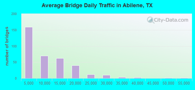
- 3,203,495Total average daily traffic
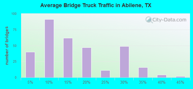
- 467,179Total average daily truck traffic
- National Bridge Inventory (NBI) Registered Bridges for Abilene
- No street view available for this location
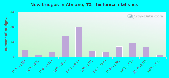
- New bridges - historical statistics
- 231920-1929
- 61930-1939
- 161940-1949
- 691950-1959
- 1001960-1969
- 181970-1979
- 171980-1989
- 351990-1999
- 462000-2009
- 342010-2019
- 62020-2022
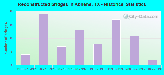
- Reconstructed bridges - Historical Statistics
- 41940-1949
- 191950-1959
- 71960-1969
- 131970-1979
- 81980-1989
- 171990-1999
- 112000-2009
- 22010-2019
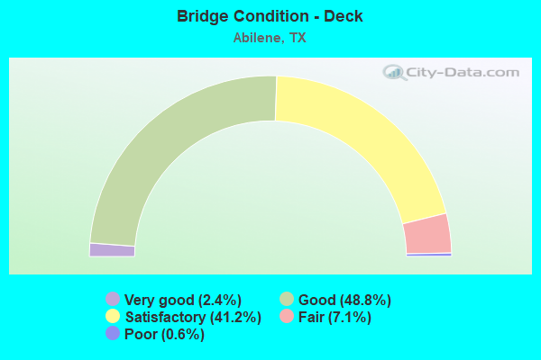
- Bridge Condition - Deck
- 2.4%Very good
- 48.8%Good
- 41.2%Satisfactory
- 7.1%Fair
- 0.6%Poor
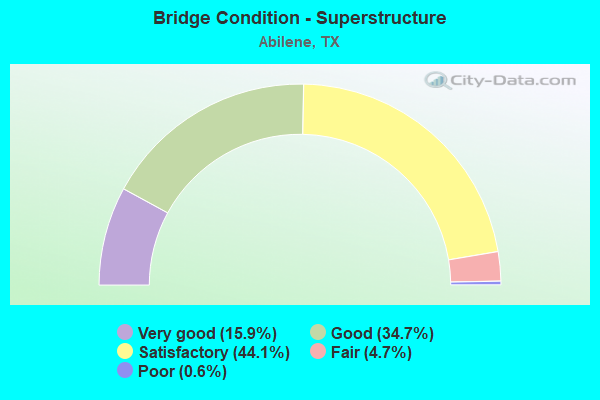
- Bridge Condition - Superstructure
- 15.9%Very good
- 34.7%Good
- 44.1%Satisfactory
- 4.7%Fair
- 0.6%Poor
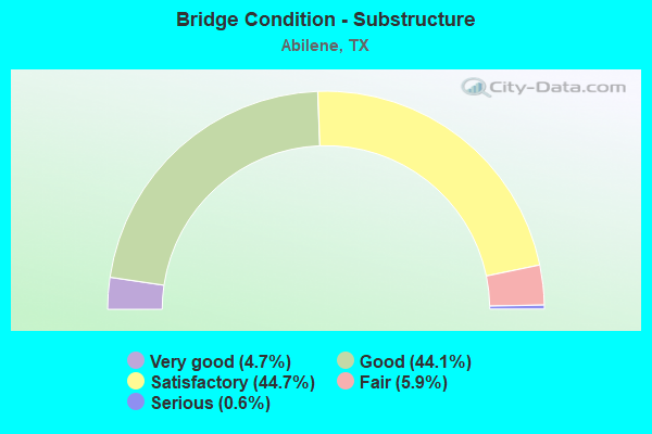
- Bridge Condition - Substructure
- 4.7%Very good
- 44.1%Good
- 44.7%Satisfactory
- 5.9%Fair
- 0.6%Serious
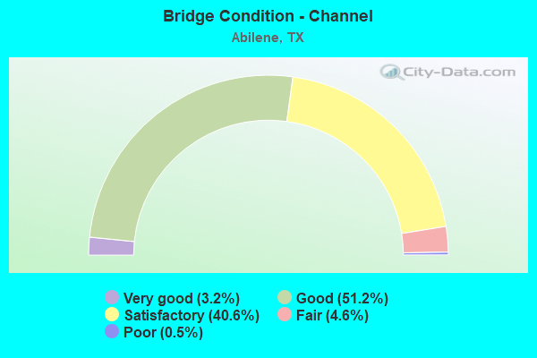
- Bridge Condition - Channel
- 3.2%Very good
- 51.2%Good
- 40.6%Satisfactory
- 4.6%Fair
- 0.5%Poor
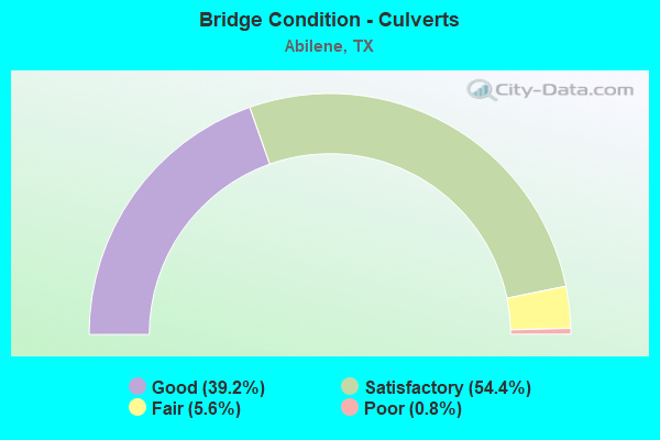
- Bridge Condition - Culverts
- 39.2%Good
- 54.4%Satisfactory
- 5.6%Fair
- 0.8%Poor
Find on map >> Show street view
Structure Number: 82210000606252, Location: 1.25 MI NW OF SH 351 (Lat: 32.488992, Lng: -99.717300), Route carried "on" structure: Interstate 20, Year Built: 1961, Status: Open, Structure Length: 1.59m (5.22ft), Average Daily Traffic: 23,291 (year 2020), Truck Traffic: 27%, Average Future Daily Traffic: 37,110 (year 2033), Design Load: HS 20, Features Intersected: CEDAR CREEK
Minimum Vertical Clearance: 30+ m (98+ ft), Kilometerpoint: 4.867, Lanes on structure: 6, Owner: State Highway Agency, Approaching Roadway Width: 30.5m (100.1ft), Skew: 30 degrees, Material/Design: Concrete, Design/Construction: Culvert, Number Of Spans In Main Unit: 6, Length of Maximum Span: 2.4m (7.9ft), Curb-To-Curb Width: 31.9m (104.7ft), Out-to-Out Width: 64.0m (210.0ft)
Condition: Channel: Satisfactory, Culverts: Satisfactory, Operating Rating: 39.9 metric tons, Method Used To Determine Operating Rating: Load Factor (LF), Inventory Rating: 23.6 metric tons, Method Used To Determine Inventory Rating: Load Factor (LF), Structural Evaluation: Somewhat better than minimum adequacy, Deck Geometry: Superior to present desirable criteria, Waterway Adequacy: Equal to present minimum criteria, Approach Roadway Alignment: Equal to present desirable criteria, Length Of Structure Improvement: 1.59m (5.22ft), Designated Inspection Frequency: Every 24 months, Inspection Date: July 2021, Bridge Improvement Cost: $6,000, Roadway Improvement Cost: $2,000, Total Project Cost: $8,000, Deck Structure Type: Concrete Cast-file-Place, Wearing Surface/Protective System: Wearing Surface: Bituminous
Find on map >> Show street view
Structure Number: 82210000606253, Location: 1.05 MI NW OF SH 351 (Lat: 32.486978, Lng: -99.714247), Route carried "on" structure: Interstate 20, Year Built: 1961, Status: Open, Structure Length: 6.10m (20.01ft), Average Daily Traffic: 13,496 (year 2019), Truck Traffic: 27%, Average Future Daily Traffic: 18,550 (year 2033), Design Load: HS 20, Features Intersected: CEDAR CREEK
Minimum Vertical Clearance: 30+ m (98+ ft), Kilometerpoint: 5.198, Lanes on structure: 2, Owner: State Highway Agency, Approaching Roadway Width: 11.3m (37.1ft), Material/Design: Concrete, Design/Construction: Stringer/Multi-beam, Number Of Spans In Main Unit: 5, Length of Maximum Span: 12.2m (40.0ft), Curb-To-Curb Width: 11.3m (37.1ft), Out-to-Out Width: 12.2m (40.0ft)
Condition: Deck: Good, Superstructure: Satisfactory, Substructure: Satisfactory, Channel: Good, Operating Rating: 57.1 metric tons, Method Used To Determine Operating Rating: Load Factor (LF), Inventory Rating: 34.5 metric tons, Method Used To Determine Inventory Rating: Load Factor (LF), Structural Evaluation: Equal to present minimum criteria, Deck Geometry: Somewhat better than minimum adequacy, Waterway Adequacy: Equal to present minimum criteria, Approach Roadway Alignment: Equal to present desirable criteria, Designated Inspection Frequency: Every 24 months, Inspection Date: April 2021, Deck Structure Type: Concrete Cast-file-Place, Wearing Surface/Protective System: Wearing Surface: Bituminous
Find on map >> Show street view
Structure Number: 82210000606254, Location: 1.05 MI NW OF SH 351 (Lat: 32.486881, Lng: -99.714450), Route carried "on" structure: Interstate 20, Year Built: 1961, Status: Open, Structure Length: 6.10m (20.01ft), Average Daily Traffic: 13,841 (year 2019), Truck Traffic: 27%, Average Future Daily Traffic: 18,550 (year 2033), Design Load: HS 20, Features Intersected: CEDAR CREEK
Minimum Vertical Clearance: 30+ m (98+ ft), Kilometerpoint: 5.198, Lanes on structure: 2, Owner: State Highway Agency, Approaching Roadway Width: 11.3m (37.1ft), Material/Design: Concrete, Design/Construction: Stringer/Multi-beam, Number Of Spans In Main Unit: 5, Length of Maximum Span: 12.2m (40.0ft), Curb-To-Curb Width: 11.3m (37.1ft), Out-to-Out Width: 12.2m (40.0ft)
Condition: Deck: Satisfactory, Superstructure: Satisfactory, Substructure: Satisfactory, Channel: Good, Operating Rating: 57.1 metric tons, Method Used To Determine Operating Rating: Load Factor (LF), Inventory Rating: 34.5 metric tons, Method Used To Determine Inventory Rating: Load Factor (LF), Structural Evaluation: Equal to present minimum criteria, Deck Geometry: Somewhat better than minimum adequacy, Waterway Adequacy: Equal to present minimum criteria, Approach Roadway Alignment: Equal to present desirable criteria, Designated Inspection Frequency: Every 24 months, Inspection Date: April 2021, Deck Structure Type: Concrete Cast-file-Place, Wearing Surface/Protective System: Wearing Surface: Bituminous
Find on map >> Show street view
Structure Number: 82210000606292, Location: 1.25 MI NW OF SH 351 (Lat: 32.488411, Lng: -99.717675), Route carried "on" structure: ServiceInterstate 20, Year Built: 1964, Status: Open, Structure Length: 1.59m (5.22ft), Average Daily Traffic: 810 (year 2013), Truck Traffic: 25%, Average Future Daily Traffic: 1,140 (year 2033), Design Load: HS 20, Features Intersected: CEDAR CREEK
Minimum Vertical Clearance: 30+ m (98+ ft), Kilometerpoint: 4.867, Lanes on structure: 2, Owner: State Highway Agency, Approaching Roadway Width: 8.2m (26.9ft), Material/Design: Concrete, Design/Construction: Culvert, Number Of Spans In Main Unit: 6, Length of Maximum Span: 2.4m (7.9ft), Curb-To-Curb Width: 8.5m (27.9ft), Out-to-Out Width: 11.4m (37.4ft)
Condition: Channel: Good, Culverts: Satisfactory, Operating Rating: 39.9 metric tons, Method Used To Determine Operating Rating: Load Factor (LF), Inventory Rating: 23.6 metric tons, Method Used To Determine Inventory Rating: Load Factor (LF), Structural Evaluation: Equal to present minimum criteria, Deck Geometry: High priority of corrective action, Waterway Adequacy: Equal to present minimum criteria, Approach Roadway Alignment: Equal to present desirable criteria, Designated Inspection Frequency: Every 24 months, Inspection Date: July 2021, Deck Structure Type: Concrete Cast-file-Place, Wearing Surface/Protective System: Wearing Surface: Bituminous
Find on map >> Show street view
Structure Number: 82210000606323, Location: 2.95 MI E of US 83 (Lat: 32.490381, Lng: -99.723003), Route carried "on" structure: State highway 600, Year Built: 2003, Status: Open, Structure Length: 7.38m (24.21ft), Average Daily Traffic: 3,230 (year 2013), Truck Traffic: 19%, Average Future Daily Traffic: 4,530 (year 2033), Design Load: HS 20, Features Intersected: IH 20
Minimum Vertical Clearance: 30+ m (98+ ft), Kilometerpoint: 5.081, Lanes on structure: 5, Lanes under structure: 4, Owner: State Highway Agency, Approaching Roadway Width: 19.5m (64.0ft), Skew: 1 degrees, Material/Design: Prestressed concrete, Design/Construction: Box Beam or Girders - Multiple, Number Of Spans In Main Unit: 2, Length of Maximum Span: 36.9m (121.1ft), Curb or Sidewalk Widths: Left: 0.0m, Right: 2.1m (6.9ft), Curb-To-Curb Width: 19.5m (64.0ft), Out-to-Out Width: 22.4m (73.5ft)
Condition: Deck: Good, Superstructure: Good, Substructure: Good, Operating Rating: 54.4 metric tons, Method Used To Determine Operating Rating: Assigned rating based on Load Factor Design (LFD) reported in metric tons, Inventory Rating: 32.7 metric tons, Method Used To Determine Inventory Rating: Assigned rating based on Load Factor Design (LFD) reported in metric tons, Structural Evaluation: Better than present minimum criteria, Deck Geometry: Meets minimum limits, Underclear: Better than present minimum criteria, Approach Roadway Alignment: Equal to present desirable criteria, Designated Inspection Frequency: Every 24 months, Inspection Date: April 2021, Deck Structure Type: Concrete Cast-file-Place
Find on map >> Show street view
Structure Number: 82210000606327, Location: 2.10 MI E OF LOOP 322 (Lat: 32.440589, Lng: -99.647725), Route carried "on" structure: Ramp State highway 20, Year Built: 2003, Status: Open, Structure Length: 11.73m (38.48ft), Average Daily Traffic: 6,800 (year 2009), Truck Traffic: 7%, Average Future Daily Traffic: 9,990 (year 2026), Design Load: HS 20, Features Intersected: IH 20 EB & SFR
Minimum Vertical Clearance: 30+ m (98+ ft), Kilometerpoint: 19.476, Lanes on structure: 1, Lanes under structure: 4, Base Highway Network: Yes, Owner: State Highway Agency, Approaching Roadway Width: 7.9m (25.9ft), Skew: 5 degrees, Material/Design: Prestressed concrete, Design/Construction: Stringer/Multi-beam, Number Of Spans In Main Unit: 4, Length of Maximum Span: 36.6m (120.1ft), Curb-To-Curb Width: 7.6m (24.9ft), Out-to-Out Width: 8.5m (27.9ft)
Condition: Deck: Good, Superstructure: Very good, Substructure: Good, Operating Rating: 54.4 metric tons, Method Used To Determine Operating Rating: Assigned rating based on Load Factor Design (LFD) reported in metric tons, Inventory Rating: 32.7 metric tons, Method Used To Determine Inventory Rating: Assigned rating based on Load Factor Design (LFD) reported in metric tons, Structural Evaluation: Better than present minimum criteria, Deck Geometry: Better than present minimum criteria, Underclear: Equal to present minimum criteria, Approach Roadway Alignment: Equal to present desirable criteria, Designated Inspection Frequency: Every 24 months, Inspection Date: April 2021, Deck Structure Type: Concrete Precast Panels
Find on map >> Show street view
Structure Number: 82210000606343, Location: 4.50 MI E OF US 83 (Lat: 32.477281, Lng: -99.699708), Route carried "on" structure: Interstate 20, Year Built: 2017, Status: Open, Structure Length: 8.08m (26.51ft), Average Daily Traffic: 13,250 (year 2013), Truck Traffic: 27%, Average Future Daily Traffic: 18,550 (year 2033), Design Load: HL 93, Features Intersected: SH 351
Minimum Vertical Clearance: 30+ m (98+ ft), Kilometerpoint: 6.946, Lanes on structure: 2, Lanes under structure: 8, Owner: State Highway Agency, Approaching Roadway Width: 17.1m (56.1ft), Skew: 2 degrees, Material/Design: Prestressed concrete, Design/Construction: Stringer/Multi-beam, Number Of Spans In Main Unit: 4, Length of Maximum Span: 21.3m (69.9ft), Curb-To-Curb Width: 17.1m (56.1ft), Out-to-Out Width: 17.6m (57.7ft)
Condition: Deck: Very good, Superstructure: Very good, Substructure: Very good, Operating Rating: 54.4 metric tons, Method Used To Determine Operating Rating: Assigned ratings based on Load and Resistance Factor Design (LRFD) reported in metric tons, Inventory Rating: 32.7 metric tons, Method Used To Determine Inventory Rating: Assigned ratings based on Load and Resistance Factor Design (LRFD) reported in metric tons, Structural Evaluation: Equal to present desirable criteria, Deck Geometry: Superior to present desirable criteria, Underclear: Meets minimum limits, Approach Roadway Alignment: Equal to present desirable criteria, Designated Inspection Frequency: Every 24 months, Inspection Date: May 2020, Deck Structure Type: Concrete Precast Panels, Wearing Surface/Protective System: Deck Protection: Epoxy Coated Reinforcing
Find on map >> Show street view
Structure Number: 82210000606344, Location: 4.5 MI E OF US 83 (Lat: 32.477272, Lng: -99.699261), Route carried "on" structure: Interstate 20, Year Built: 2017, Status: Open, Structure Length: 8.08m (26.51ft), Average Daily Traffic: 17,588 (year 2019), Truck Traffic: 27%, Average Future Daily Traffic: 24,620 (year 2033), Design Load: HL 93, Features Intersected: SH 351
Minimum Vertical Clearance: 30+ m (98+ ft), Kilometerpoint: 6.946, Lanes on structure: 2, Lanes under structure: 8, Base Highway Network: Yes, Owner: State Highway Agency, Approaching Roadway Width: 17.1m (56.1ft), Skew: 2 degrees, Material/Design: Prestressed concrete, Design/Construction: Stringer/Multi-beam, Number Of Spans In Main Unit: 4, Length of Maximum Span: 21.3m (69.9ft), Curb-To-Curb Width: 17.1m (56.1ft), Out-to-Out Width: 18.0m (59.1ft)
Condition: Deck: Good, Superstructure: Very good, Substructure: Very good, Operating Rating: 54.4 metric tons, Method Used To Determine Operating Rating: Assigned ratings based on Load and Resistance Factor Design (LRFD) reported in metric tons, Inventory Rating: 32.7 metric tons, Method Used To Determine Inventory Rating: Assigned ratings based on Load and Resistance Factor Design (LRFD) reported in metric tons, Structural Evaluation: Equal to present desirable criteria, Deck Geometry: Superior to present desirable criteria, Underclear: High priority of corrective action, Approach Roadway Alignment: Equal to present desirable criteria, Designated Inspection Frequency: Every 24 months, Inspection Date: May 2020, Deck Structure Type: Concrete Precast Panels, Wearing Surface/Protective System: Deck Protection: Epoxy Coated Reinforcing
Find on map >> Show street view
Structure Number: 82210000618028, Location: 1.50 MI W OF US 84 (Lat: 32.454258, Lng: -99.811667), Route carried "on" structure: US 84, Year Built: 1928, Year Reconstructed: 2010, Status: Open, Structure Length: 3.32m (10.89ft), Average Daily Traffic: 5,240 (year 2013), Truck Traffic: 8%, Average Future Daily Traffic: 7,330 (year 2033), Design Load: H 15, Features Intersected: Little Elm Creek Branch
Minimum Vertical Clearance: 30+ m (98+ ft), Kilometerpoint: 3.833, Lanes on structure: 6, Owner: State Highway Agency, Approaching Roadway Width: 23.2m (76.1ft), Skew: 39 degrees, Material/Design: Concrete, Design/Construction: Culvert, Number Of Spans In Main Unit: 14, Length of Maximum Span: 2.7m (8.9ft)
Condition: Channel: Good, Culverts: Satisfactory, Operating Rating: 39.9 metric tons, Method Used To Determine Operating Rating: Load Factor (LF), Inventory Rating: 23.6 metric tons, Method Used To Determine Inventory Rating: Load Factor (LF), Structural Evaluation: Somewhat better than minimum adequacy, Waterway Adequacy: Equal to present minimum criteria, Approach Roadway Alignment: Equal to present desirable criteria, Designated Inspection Frequency: Every 24 months, Inspection Date: April 2021
Find on map >> Show street view
Structure Number: 82210000618031, Location: 2.90 MI E OF IH 20 (Lat: 32.453300, Lng: -99.801406), Route carried "on" structure: US 84, Year Built: 1957, Status: Open, Structure Length: 2.65m (8.69ft), Average Daily Traffic: 5,115 (year 2019), Truck Traffic: 12%, Average Future Daily Traffic: 11,890 (year 2033), Features Intersected: Draw
Minimum Vertical Clearance: 30+ m (98+ ft), Kilometerpoint: 4.807, Lanes on structure: 2, Owner: State Highway Agency, Approaching Roadway Width: 11.0m (36.1ft), Material/Design: Concrete, Design/Construction: Culvert, Number Of Spans In Main Unit: 10, Length of Maximum Span: 2.4m (7.9ft), Curb-To-Curb Width: 11.3m (37.1ft), Out-to-Out Width: 13.8m (45.3ft)
Condition: Channel: Good, Culverts: Satisfactory, Operating Rating: 39.9 metric tons, Method Used To Determine Operating Rating: Load Factor (LF), Inventory Rating: 23.6 metric tons, Method Used To Determine Inventory Rating: Load Factor (LF), Structural Evaluation: Somewhat better than minimum adequacy, Deck Geometry: Equal to present minimum criteria, Waterway Adequacy: Equal to present minimum criteria, Approach Roadway Alignment: Equal to present desirable criteria, Designated Inspection Frequency: Every 24 months, Inspection Date: April 2021, Deck Structure Type: Concrete Cast-file-Place, Wearing Surface/Protective System: Wearing Surface: Bituminous
Find on map >> Show street view
Structure Number: 82210000618032, Location: 0.70 MI E OF US 83 (Lat: 32.451550, Lng: -99.773594), Route carried "on" structure: Business State highway 20, Year Built: 1928, Year Reconstructed: 1959, Status: Open, Structure Length: 1.77m (5.81ft), Average Daily Traffic: 8,760 (year 2020), Truck Traffic: 7%, Average Future Daily Traffic: 20,270 (year 2033), Design Load: H 15, Features Intersected: MOORE SLOUGH
Minimum Vertical Clearance: 30+ m (98+ ft), Kilometerpoint: 7.421, Lanes on structure: 5, Owner: State Highway Agency, Approaching Roadway Width: 21.9m (71.9ft), Material/Design: Concrete, Design/Construction: Culvert, Number Of Spans In Main Unit: 10, Length of Maximum Span: 1.5m (4.9ft), Curb-To-Curb Width: 21.9m (71.9ft), Out-to-Out Width: 22.6m (74.1ft)
Condition: Channel: Satisfactory, Culverts: Satisfactory, Operating Rating: 39.9 metric tons, Method Used To Determine Operating Rating: Load Factor (LF), Inventory Rating: 23.6 metric tons, Method Used To Determine Inventory Rating: Load Factor (LF), Structural Evaluation: Somewhat better than minimum adequacy, Deck Geometry: Somewhat better than minimum adequacy, Waterway Adequacy: Equal to present minimum criteria, Approach Roadway Alignment: Equal to present desirable criteria, Designated Inspection Frequency: Every 24 months, Inspection Date: April 2021, Deck Structure Type: Concrete Cast-file-Place, Wearing Surface/Protective System: Wearing Surface: Bituminous
Find on map >> Show street view
Structure Number: 82210000618033, Location: 1.00 MI E OF US 83 (Lat: 32.451242, Lng: -99.769047), Route carried "on" structure: Business State highway 20, Year Built: 1928, Year Reconstructed: 1959, Status: Open, Structure Length: 3.38m (11.09ft), Average Daily Traffic: 13,143 (year 2020), Truck Traffic: 7%, Average Future Daily Traffic: 20,270 (year 2033), Design Load: H 15, Features Intersected: BIG ELM CREEK
Minimum Vertical Clearance: 30+ m (98+ ft), Kilometerpoint: 7.842, Lanes on structure: 5, Owner: State Highway Agency, Approaching Roadway Width: 18.9m (62.0ft), Material/Design: Concrete, Design/Construction: Tee Beam, Number Of Spans In Main Unit: 3, Length of Maximum Span: 11.3m (37.1ft), Curb-To-Curb Width: 20.9m (68.6ft), Out-to-Out Width: 21.6m (70.9ft)
Condition: Deck: Satisfactory, Superstructure: Satisfactory, Substructure: Satisfactory, Channel: Satisfactory, Operating Rating: 49.0 metric tons, Method Used To Determine Operating Rating: Load Factor (LF), Inventory Rating: 29.0 metric tons, Method Used To Determine Inventory Rating: Load Factor (LF), Structural Evaluation: Equal to present minimum criteria, Deck Geometry: Somewhat better than minimum adequacy, Waterway Adequacy: Equal to present minimum criteria, Approach Roadway Alignment: Equal to present desirable criteria, Designated Inspection Frequency: Every 24 months, Inspection Date: April 2021, Deck Structure Type: Concrete Cast-file-Place, Wearing Surface/Protective System: Wearing Surface: Bituminous
Find on map >> Show street view
Structure Number: 82210000618034, Location: 1.90 MI E OF US 83 (Lat: 32.450086, Lng: -99.752686), Route carried "on" structure: Business State highway 20, Year Built: 1928, Year Reconstructed: 1959, Status: Open, Structure Length: 2.74m (8.99ft), Average Daily Traffic: 7,335 (year 2020), Truck Traffic: 11%, Average Future Daily Traffic: 15,310 (year 2033), Design Load: H 15, Features Intersected: CATCLAW CREEK
Minimum Vertical Clearance: 30+ m (98+ ft), Kilometerpoint: 9.389, Lanes on structure: 5, Owner: State Highway Agency, Approaching Roadway Width: 17.7m (58.1ft), Material/Design: Concrete, Design/Construction: Culvert, Number Of Spans In Main Unit: 10, Length of Maximum Span: 2.4m (7.9ft), Curb or Sidewalk Widths: Left: 1.7m (5.6ft), Right: 1.7m (5.6ft), Curb-To-Curb Width: 18.3m (60.0ft), Out-to-Out Width: 22.3m (73.2ft)
Condition: Channel: Satisfactory, Culverts: Satisfactory, Operating Rating: 39.9 metric tons, Method Used To Determine Operating Rating: Load Factor (LF), Inventory Rating: 23.6 metric tons, Method Used To Determine Inventory Rating: Load Factor (LF), Structural Evaluation: Somewhat better than minimum adequacy, Deck Geometry: High priority of replacement, Waterway Adequacy: Equal to present minimum criteria, Approach Roadway Alignment: Equal to present desirable criteria, Designated Inspection Frequency: Every 24 months, Inspection Date: April 2021, Deck Structure Type: Concrete Cast-file-Place, Wearing Surface/Protective System: Wearing Surface: Bituminous
Find on map >> Show street view
Structure Number: 8221000061805, Location: 1.65 MI E OF LP 322 (Lat: 32.441239, Lng: -99.656028), Route carried "on" structure: Business State highway 20, Year Built: 1948, Status: Open, Structure Length: 2.01m (6.59ft), Average Daily Traffic: 7,070 (year 2013), Truck Traffic: 11%, Average Future Daily Traffic: 9,900 (year 2033), Design Load: H 15, Features Intersected: E FORK RAINY CREEK
Minimum Vertical Clearance: 30+ m (98+ ft), Kilometerpoint: 18.779, Lanes on structure: 4, Owner: State Highway Agency, Approaching Roadway Width: 14.0m (45.9ft), Material/Design: Concrete, Design/Construction: Culvert, Number Of Spans In Main Unit: 10, Length of Maximum Span: 1.8m (5.9ft), Curb-To-Curb Width: 14.6m (47.9ft), Out-to-Out Width: 15.5m (50.9ft)
Condition: Channel: Good, Culverts: Satisfactory, Operating Rating: 39.9 metric tons, Method Used To Determine Operating Rating: Load Factor (LF), Inventory Rating: 23.6 metric tons, Method Used To Determine Inventory Rating: Load Factor (LF), Structural Evaluation: Somewhat better than minimum adequacy, Deck Geometry: High priority of replacement, Waterway Adequacy: Equal to present minimum criteria, Approach Roadway Alignment: Equal to present desirable criteria, Length Of Structure Improvement: 2.01m (6.59ft), Designated Inspection Frequency: Every 24 months, Inspection Date: April 2021, Bridge Improvement Cost: $6,000, Roadway Improvement Cost: $2,000, Total Project Cost: $8,000, Deck Structure Type: Concrete Cast-file-Place, Wearing Surface/Protective System: Wearing Surface: Bituminous
Find on map >> Show street view
Structure Number: 82210000618054, Location: 2.35 MI W OF LP 322 (Lat: 32.449506, Lng: -99.722975), Route carried "on" structure: Business State highway 20, Year Built: 1951, Year Reconstructed: 1986, Status: Open, Structure Length: 9.81m (32.19ft), Average Daily Traffic: 12,830 (year 2013), Truck Traffic: 11%, Average Future Daily Traffic: 17,960 (year 2033), Design Load: HS 20, Features Intersected: Southern Switching RR
Minimum Vertical Clearance: 30+ m (98+ ft), Kilometerpoint: 12.299, Lanes on structure: 4, Base Highway Network: Yes, Owner: State Highway Agency, Approaching Roadway Width: 15.9m (52.2ft), Skew: 30 degrees, Material/Design: Steel, Design/Construction: Stringer/Multi-beam, Number Of Spans In Main Unit: 8, Length of Maximum Span: 12.2m (40.0ft), Curb or Sidewalk Widths: Left: 1.8m (5.9ft), Right: 1.8m (5.9ft), Curb-To-Curb Width: 16.0m (52.5ft), Out-to-Out Width: 21.9m (71.9ft)
Condition: Deck: Good, Superstructure: Very good, Substructure: Good, Operating Rating: 68.0 metric tons, Method Used To Determine Operating Rating: Load Factor (LF), Inventory Rating: 40.8 metric tons, Method Used To Determine Inventory Rating: Load Factor (LF), Structural Evaluation: Better than present minimum criteria, Deck Geometry: Meets minimum limits, Underclear: Meets minimum limits, Approach Roadway Alignment: Equal to present desirable criteria, Length Of Structure Improvement: 9.81m (32.19ft), Designated Inspection Frequency: Every 24 months, Inspection Date: April 2021, Deck Structure Type: Concrete Cast-file-Place
Find on map >> Show street view
Structure Number: 82210000618055, Location: 2.20 MI W OF LP 322 (Lat: 32.449328, Lng: -99.720664), Route carried "on" structure: Business State highway 20, Year Built: 1951, Year Reconstructed: 1986, Status: Open, Structure Length: 6.16m (20.21ft), Average Daily Traffic: 12,224 (year 2020), Truck Traffic: 11%, Average Future Daily Traffic: 17,960 (year 2033), Design Load: HS 20, Features Intersected: CEDAR CREEK
Minimum Vertical Clearance: 30+ m (98+ ft), Kilometerpoint: 12.543, Lanes on structure: 4, Base Highway Network: Yes, Owner: State Highway Agency, Approaching Roadway Width: 15.9m (52.2ft), Skew: 30 degrees, Material/Design: Steel, Design/Construction: Stringer/Multi-beam, Number Of Spans In Main Unit: 5, Length of Maximum Span: 12.2m (40.0ft), Curb or Sidewalk Widths: Left: 1.7m (5.6ft), Right: 1.7m (5.6ft), Curb-To-Curb Width: 16.3m (53.5ft), Out-to-Out Width: 21.9m (71.9ft)
Condition: Deck: Good, Superstructure: Satisfactory, Substructure: Serious, Channel: Good, Operating Rating: 68.0 metric tons, Method Used To Determine Operating Rating: Load Factor (LF), Inventory Rating: 40.8 metric tons, Method Used To Determine Inventory Rating: Load Factor (LF), Structural Evaluation: High priority of corrective action, Deck Geometry: Meets minimum limits, Waterway Adequacy: Equal to present minimum criteria, Approach Roadway Alignment: Equal to present desirable criteria, Length Of Structure Improvement: 6.16m (20.21ft), Designated Inspection Frequency: Every 24 months, Inspection Date: April 2021, Deck Structure Type: Concrete Cast-file-Place
Find on map >> Show street view
Structure Number: 82210000618089, Location: 2.90 MI E OF IH 20 (Lat: 32.453525, Lng: -99.801125), Route carried "on" structure: US 84, Year Built: 1928, Year Reconstructed: 1948, Status: Open, Structure Length: 2.74m (8.99ft), Average Daily Traffic: 9,446 (year 2019), Truck Traffic: 12%, Average Future Daily Traffic: 11,890 (year 2033), Design Load: H 15, Features Intersected: Draw
Minimum Vertical Clearance: 30+ m (98+ ft), Kilometerpoint: 4.807, Lanes on structure: 2, Owner: State Highway Agency, Approaching Roadway Width: 11.6m (38.1ft), Material/Design: Concrete, Design/Construction: Culvert, Number Of Spans In Main Unit: 10, Length of Maximum Span: 2.4m (7.9ft), Curb-To-Curb Width: 11.4m (37.4ft), Out-to-Out Width: 12.2m (40.0ft)
Condition: Channel: Good, Culverts: Fair, Operating Rating: 39.9 metric tons, Method Used To Determine Operating Rating: Load Factor (LF), Inventory Rating: 23.6 metric tons, Method Used To Determine Inventory Rating: Load Factor (LF), Structural Evaluation: Somewhat better than minimum adequacy, Deck Geometry: Equal to present minimum criteria, Waterway Adequacy: Equal to present minimum criteria, Approach Roadway Alignment: Equal to present desirable criteria, Designated Inspection Frequency: Every 24 months, Inspection Date: April 2021, Deck Structure Type: Concrete Cast-file-Place, Wearing Surface/Protective System: Wearing Surface: Bituminous
Find on map >> Show street view
Structure Number: 82210000618145, Location: 2.65 MI E OF IH 20 (Lat: 32.453236, Lng: -99.804025), Route carried "on" structure: ServiceUS 84, Year Built: 1958, Status: Open, Structure Length: 2.07m (6.79ft), Average Daily Traffic: 100 (year 2013), Truck Traffic: 8%, Average Future Daily Traffic: 140 (year 2033), Features Intersected: LITTLE ELM CREEK
Minimum Vertical Clearance: 30+ m (98+ ft), Kilometerpoint: 4.540, Lanes on structure: 2, Owner: State Highway Agency, Approaching Roadway Width: 6.7m (22.0ft), Material/Design: Concrete, Design/Construction: Culvert, Number Of Spans In Main Unit: 8, Length of Maximum Span: 2.4m (7.9ft), Curb-To-Curb Width: 9.1m (29.9ft), Out-to-Out Width: 9.5m (31.2ft)
Condition: Channel: Satisfactory, Culverts: Satisfactory, Operating Rating: 39.9 metric tons, Method Used To Determine Operating Rating: Load Factor (LF), Inventory Rating: 23.6 metric tons, Method Used To Determine Inventory Rating: Load Factor (LF), Structural Evaluation: Equal to present minimum criteria, Deck Geometry: Better than present minimum criteria, Waterway Adequacy: High priority of corrective action, Approach Roadway Alignment: Equal to present desirable criteria, Designated Inspection Frequency: Every 24 months, Inspection Date: July 2021, Deck Structure Type: Concrete Cast-file-Place, Wearing Surface/Protective System: Wearing Surface: Bituminous
Find on map >> Show street view
Structure Number: 82210000618225, Location: 1.70 MI E OF US 83 (Lat: 32.450453, Lng: -99.758064), Route carried "on" structure: Business State highway 20, Year Built: 1959, Status: Open, Structure Length: 1.98m (6.50ft), Average Daily Traffic: 14,470 (year 2013), Truck Traffic: 7%, Average Future Daily Traffic: 20,270 (year 2033), Design Load: H 20, Features Intersected: MOCKINGBIRD LN
Minimum Vertical Clearance: 30+ m (98+ ft), Kilometerpoint: 8.887, Lanes on structure: 5, Lanes under structure: 4, Owner: State Highway Agency, Approaching Roadway Width: 18.3m (60.0ft), Material/Design: Concrete continuous, Design/Construction: Slab, Number Of Spans In Main Unit: 2, Length of Maximum Span: 10.1m (33.1ft), Curb or Sidewalk Widths: Left: 1.3m (4.3ft), Right: 1.3m (4.3ft), Curb-To-Curb Width: 18.3m (60.0ft), Out-to-Out Width: 23.5m (77.1ft)
Condition: Deck: Satisfactory, Superstructure: Satisfactory, Substructure: Satisfactory, Operating Rating: 55.3 metric tons, Method Used To Determine Operating Rating: Load Factor (LF), Inventory Rating: 33.6 metric tons, Method Used To Determine Inventory Rating: Load Factor (LF), Structural Evaluation: Equal to present minimum criteria, Deck Geometry: High priority of replacement, Underclear: Meets minimum limits, Approach Roadway Alignment: Equal to present desirable criteria, Length Of Structure Improvement: 1.98m (6.50ft), Designated Inspection Frequency: Every 24 months, Inspection Date: April 2021, Bridge Improvement Cost: $116,000, Roadway Improvement Cost: $81,000, Total Project Cost: $225,000, Deck Structure Type: Concrete Cast-file-Place, Wearing Surface/Protective System: Wearing Surface: Bituminous
Find on map >> Show street view
Structure Number: 82210000618241, Location: 2.20 MI E OF IH 20 (Lat: 32.453817, Lng: -99.811753), Route carried "on" structure: ServiceUS 84, Year Built: 1959, Status: Open, Structure Length: 1.22m (4.00ft), Average Daily Traffic: 180 (year 2013), Truck Traffic: 10%, Average Future Daily Traffic: 260 (year 2033), Features Intersected: LITTLE ELM CREEK BRANCH
Minimum Vertical Clearance: 30+ m (98+ ft), Kilometerpoint: 3.833, Lanes on structure: 2, Owner: State Highway Agency, Approaching Roadway Width: 6.1m (20.0ft), Material/Design: Concrete, Design/Construction: Culvert, Number Of Spans In Main Unit: 7, Length of Maximum Span: 1.5m (4.9ft), Curb-To-Curb Width: 9.1m (29.9ft), Out-to-Out Width: 9.5m (31.2ft)
Condition: Channel: Good, Culverts: Good, Operating Rating: 39.9 metric tons, Method Used To Determine Operating Rating: Load Factor (LF), Inventory Rating: 23.6 metric tons, Method Used To Determine Inventory Rating: Load Factor (LF), Structural Evaluation: Equal to present minimum criteria, Deck Geometry: Equal to present minimum criteria, Waterway Adequacy: Equal to present minimum criteria, Approach Roadway Alignment: Equal to present desirable criteria, Designated Inspection Frequency: Every 24 months, Inspection Date: July 2021, Deck Structure Type: Concrete Cast-file-Place, Wearing Surface/Protective System: Wearing Surface: Bituminous
Find on map >> Show street view
Structure Number: 82210000618243, Location: 3.15 MI E OF US 83 (Lat: 32.448542, Lng: -99.733136), Route carried "on" structure: Business State highway 20, Year Built: 1960, Status: Open, Structure Length: 1.86m (6.10ft), Average Daily Traffic: 10,940 (year 2013), Truck Traffic: 11%, Average Future Daily Traffic: 15,310 (year 2033), Design Load: H 20, Features Intersected: PINE ST
Minimum Vertical Clearance: 30+ m (98+ ft), Kilometerpoint: 11.243, Lanes on structure: 4, Lanes under structure: 4, Owner: State Highway Agency, Approaching Roadway Width: 13.4m (44.0ft), Material/Design: Concrete continuous, Design/Construction: Slab, Number Of Spans In Main Unit: 2, Length of Maximum Span: 9.1m (29.9ft), Curb or Sidewalk Widths: Left: 1.8m (5.9ft), Right: 0.0m, Curb-To-Curb Width: 13.4m (44.0ft), Out-to-Out Width: 21.2m (69.6ft)
Condition: Deck: Fair, Superstructure: Fair, Substructure: Satisfactory, Operating Rating: 49.9 metric tons, Method Used To Determine Operating Rating: Load Factor (LF), Inventory Rating: 29.9 metric tons, Method Used To Determine Inventory Rating: Load Factor (LF), Structural Evaluation: Somewhat better than minimum adequacy, Deck Geometry: High priority of replacement, Underclear: High priority of corrective action, Approach Roadway Alignment: Equal to present desirable criteria, Length Of Structure Improvement: 1.83m (6.00ft), Designated Inspection Frequency: Every 24 months, Inspection Date: April 2021, Bridge Improvement Cost: $370,000, Roadway Improvement Cost: $37,000, Total Project Cost: $555,000, Deck Structure Type: Concrete Cast-file-Place, Wearing Surface/Protective System: Wearing Surface: Bituminous
Find on map >> Show street view
Structure Number: 82210000618329, Location: INTERSECT FM 3438 & US 84 (Lat: 32.452875, Lng: -99.808297), Route carried "on" structure: State highway 3438, Year Built: 2010, Status: Open, Structure Length: 39.17m (128.51ft), Average Daily Traffic: 2,090 (year 2013), Truck Traffic: 20%, Average Future Daily Traffic: 2,930 (year 2033), Design Load: HL 93, Features Intersected: US84/IH20BUS/LittleElmCr
Minimum Vertical Clearance: 30+ m (98+ ft), Kilometerpoint: 1.905, Lanes on structure: 2, Lanes under structure: 6, Base Highway Network: Yes, Owner: State Highway Agency, Approaching Roadway Width: 25.6m (84.0ft), Material/Design: Prestressed concrete, Design/Construction: Stringer/Multi-beam, Number Of Spans In Main Unit: 8, Number Of Approach Spans: 4, Length of Maximum Span: 39.6m (129.9ft), Curb-To-Curb Width: 25.4m (83.3ft), Out-to-Out Width: 26.2m (86.0ft)
Condition: Deck: Good, Superstructure: Good, Substructure: Satisfactory, Channel: Good, Operating Rating: 54.4 metric tons, Method Used To Determine Operating Rating: Assigned ratings based on Load and Resistance Factor Design (LRFD) reported in metric tons, Inventory Rating: 32.7 metric tons, Method Used To Determine Inventory Rating: Assigned ratings based on Load and Resistance Factor Design (LRFD) reported in metric tons, Structural Evaluation: Equal to present minimum criteria, Deck Geometry: Superior to present desirable criteria, Underclear: Somewhat better than minimum adequacy, Waterway Adequacy: Superior to present desirable criteria, Approach Roadway Alignment: Equal to present desirable criteria, Designated Inspection Frequency: Every 24 months, Inspection Date: July 2021, Deck Structure Type: Concrete Precast Panels, Wearing Surface/Protective System: Deck Protection: Epoxy Coated Reinforcing
Find on map >> Show street view
Structure Number: 8221000061833, Location: FM 3438 @ US 84 (Lat: 32.454122, Lng: -99.808444), Route carried "on" structure: Ramp US 84, Year Built: 2010, Status: Open, Structure Length: 10.88m (35.70ft), Average Daily Traffic: 1,040 (year 2013), Truck Traffic: 8%, Average Future Daily Traffic: 1,460 (year 2033), Design Load: HL 93, Features Intersected: OPEN
Minimum Vertical Clearance: 30+ m (98+ ft), Kilometerpoint: 3.996, Lanes on structure: 1, Owner: State Highway Agency, Approaching Roadway Width: 17.4m (57.1ft), Material/Design: Prestressed concrete, Design/Construction: Stringer/Multi-beam, Number Of Spans In Main Unit: 3, Length of Maximum Span: 36.6m (120.1ft), Curb-To-Curb Width: 9.3m (30.5ft), Out-to-Out Width: 10.0m (32.8ft)
Condition: Deck: Good, Superstructure: Very good, Substructure: Good, Operating Rating: 54.4 metric tons, Method Used To Determine Operating Rating: Assigned ratings based on Load and Resistance Factor Design (LRFD) reported in metric tons, Inventory Rating: 32.7 metric tons, Method Used To Determine Inventory Rating: Assigned ratings based on Load and Resistance Factor Design (LRFD) reported in metric tons, Structural Evaluation: Better than present minimum criteria, Deck Geometry: Superior to present desirable criteria, Approach Roadway Alignment: Equal to present desirable criteria, Designated Inspection Frequency: Every 24 months, Inspection Date: July 2021, Deck Structure Type: Concrete Precast Panels
Find on map >> Show street view
Structure Number: 82210000618331, Location: FM 3438 @ US 84 (Lat: 32.453681, Lng: -99.809267), Route carried "on" structure: Ramp US 84, Year Built: 2010, Status: Open, Structure Length: 7.22m (23.69ft), Average Daily Traffic: 1,040 (year 2013), Truck Traffic: 8%, Average Future Daily Traffic: 1,460 (year 2033), Design Load: HL 93, Features Intersected: OPEN
Minimum Vertical Clearance: 30+ m (98+ ft), Kilometerpoint: 4.033, Lanes on structure: 2, Owner: State Highway Agency, Approaching Roadway Width: 11.0m (36.1ft), Material/Design: Prestressed concrete, Design/Construction: Stringer/Multi-beam, Number Of Spans In Main Unit: 2, Length of Maximum Span: 36.6m (120.1ft), Curb-To-Curb Width: 10.9m (35.8ft), Out-to-Out Width: 11.6m (38.1ft)
Condition: Deck: Good, Superstructure: Good, Substructure: Good, Operating Rating: 54.4 metric tons, Method Used To Determine Operating Rating: Assigned ratings based on Load and Resistance Factor Design (LRFD) reported in metric tons, Inventory Rating: 32.7 metric tons, Method Used To Determine Inventory Rating: Assigned ratings based on Load and Resistance Factor Design (LRFD) reported in metric tons, Structural Evaluation: Better than present minimum criteria, Deck Geometry: Better than present minimum criteria, Approach Roadway Alignment: Equal to present desirable criteria, Designated Inspection Frequency: Every 24 months, Inspection Date: July 2021, Deck Structure Type: Concrete Precast Panels
Find on map >> Show street view
Structure Number: 82210000618332, Location: FM 3438 @ US 84 (Lat: 32.453897, Lng: -99.806303), Route carried "on" structure: Ramp US 84, Year Built: 2010, Status: Open, Structure Length: 17.43m (57.19ft), Average Daily Traffic: 1,040 (year 2013), Truck Traffic: 8%, Average Future Daily Traffic: 1,460 (year 2033), Design Load: HL 93, Features Intersected: LITTLE ELM CREEK BRANCH
Minimum Vertical Clearance: 30+ m (98+ ft), Kilometerpoint: 4.134, Lanes on structure: 2, Owner: State Highway Agency, Approaching Roadway Width: 11.0m (36.1ft), Material/Design: Prestressed concrete, Design/Construction: Stringer/Multi-beam, Number Of Spans In Main Unit: 5, Length of Maximum Span: 35.1m (115.2ft), Curb-To-Curb Width: 10.9m (35.8ft), Out-to-Out Width: 11.6m (38.1ft)
Condition: Deck: Good, Superstructure: Very good, Substructure: Good, Channel: Satisfactory, Operating Rating: 54.4 metric tons, Method Used To Determine Operating Rating: Assigned ratings based on Load and Resistance Factor Design (LRFD) reported in metric tons, Inventory Rating: 32.7 metric tons, Method Used To Determine Inventory Rating: Assigned ratings based on Load and Resistance Factor Design (LRFD) reported in metric tons, Structural Evaluation: Better than present minimum criteria, Deck Geometry: Better than present minimum criteria, Waterway Adequacy: Superior to present desirable criteria, Approach Roadway Alignment: Equal to present desirable criteria, Designated Inspection Frequency: Every 24 months, Inspection Date: July 2021, Deck Structure Type: Concrete Precast Panels
Find on map >> Show street view
Structure Number: 82210000618333, Location: FM 3438 @ US 84 (Lat: 32.453578, Lng: -99.808181), Route carried "on" structure: Ramp US 84, Year Built: 2010, Status: Open, Structure Length: 17.43m (57.19ft), Average Daily Traffic: 1,040 (year 2013), Truck Traffic: 8%, Average Future Daily Traffic: 1,460 (year 2033), Design Load: HL 93, Features Intersected: LITTLE ELM CREEK BRANCH
Minimum Vertical Clearance: 30+ m (98+ ft), Kilometerpoint: 4.134, Lanes on structure: 1, Owner: State Highway Agency, Approaching Roadway Width: 11.0m (36.1ft), Material/Design: Prestressed concrete, Design/Construction: Stringer/Multi-beam, Number Of Spans In Main Unit: 5, Length of Maximum Span: 35.1m (115.2ft), Curb-To-Curb Width: 7.5m (24.6ft), Out-to-Out Width: 8.2m (26.9ft)
Condition: Deck: Good, Superstructure: Very good, Substructure: Good, Channel: Good, Operating Rating: 54.4 metric tons, Method Used To Determine Operating Rating: Assigned ratings based on Load and Resistance Factor Design (LRFD) reported in metric tons, Inventory Rating: 32.7 metric tons, Method Used To Determine Inventory Rating: Assigned ratings based on Load and Resistance Factor Design (LRFD) reported in metric tons, Structural Evaluation: Better than present minimum criteria, Deck Geometry: Better than present minimum criteria, Waterway Adequacy: Superior to present desirable criteria, Approach Roadway Alignment: Equal to present desirable criteria, Designated Inspection Frequency: Every 24 months, Inspection Date: July 2021, Deck Structure Type: Concrete Precast Panels
Find on map >> Show street view
Structure Number: 82210000618334, Location: 2.55 MI E OF IH 20 (Lat: 32.453894, Lng: -99.806517), Route carried "on" structure: US 84, Year Built: 2010, Status: Open, Structure Length: 1.86m (6.10ft), Average Daily Traffic: 8,073 (year 2020), Truck Traffic: 8%, Average Future Daily Traffic: 14,670 (year 2033), Design Load: HL 93, Features Intersected: LITTLE ELM CR W RELIEF
Minimum Vertical Clearance: 30+ m (98+ ft), Kilometerpoint: 4.279, Lanes on structure: 4, Owner: State Highway Agency, Approaching Roadway Width: 24.4m (80.1ft), Skew: 30 degrees, Material/Design: Concrete, Design/Construction: Culvert, Number Of Spans In Main Unit: 7, Length of Maximum Span: 2.4m (7.9ft), Curb-To-Curb Width: 29.1m (95.5ft), Out-to-Out Width: 29.9m (98.1ft)
Condition: Channel: Satisfactory, Culverts: Good, Operating Rating: 44.4 metric tons, Method Used To Determine Operating Rating: Assigned ratings based on Load and Resistance Factor Design (LRFD) reported in metric tons, Inventory Rating: 32.7 metric tons, Method Used To Determine Inventory Rating: Assigned ratings based on Load and Resistance Factor Design (LRFD) reported in metric tons, Structural Evaluation: Better than present minimum criteria, Deck Geometry: Superior to present desirable criteria, Waterway Adequacy: Equal to present minimum criteria, Approach Roadway Alignment: Equal to present desirable criteria, Designated Inspection Frequency: Every 48 months, Inspection Date: July 2019, Deck Structure Type: Concrete Cast-file-Place, Wearing Surface/Protective System: Wearing Surface: Bituminous
Find on map >> Show street view
Structure Number: 82210000618335, Location: 1.00 MI W OF US 83/277 (Lat: 32.453683, Lng: -99.803783), Route carried "on" structure: US 84, Year Built: 2009, Status: Open, Structure Length: 4.27m (14.01ft), Average Daily Traffic: 9,446 (year 2019), Truck Traffic: 12%, Average Future Daily Traffic: 11,890 (year 2033), Design Load: HL 93, Features Intersected: LITTLE ELM CREEK
Minimum Vertical Clearance: 30+ m (98+ ft), Kilometerpoint: 4.505, Lanes on structure: 3, Owner: State Highway Agency, Approaching Roadway Width: 18.3m (60.0ft), Material/Design: Prestressed concrete, Design/Construction: Stringer/Multi-beam, Number Of Spans In Main Unit: 3, Length of Maximum Span: 15.2m (49.9ft), Curb-To-Curb Width: 18.4m (60.4ft), Out-to-Out Width: 19.1m (62.7ft)
Condition: Deck: Good, Superstructure: Very good, Substructure: Good, Channel: Good, Operating Rating: 54.4 metric tons, Method Used To Determine Operating Rating: Assigned ratings based on Load and Resistance Factor Design (LRFD) reported in metric tons, Inventory Rating: 32.7 metric tons, Method Used To Determine Inventory Rating: Assigned ratings based on Load and Resistance Factor Design (LRFD) reported in metric tons, Structural Evaluation: Better than present minimum criteria, Deck Geometry: Superior to present desirable criteria, Waterway Adequacy: Superior to present desirable criteria, Approach Roadway Alignment: Equal to present desirable criteria, Designated Inspection Frequency: Every 24 months, Inspection Date: April 2021, Deck Structure Type: Concrete Cast-file-Place, Wearing Surface/Protective System: Deck Protection: Epoxy Coated Reinforcing
Find on map >> Show street view
Structure Number: 82210000618336, Location: 1.00 MI W OF US 83/277 (Lat: 32.453408, Lng: -99.804269), Route carried "on" structure: US 84, Year Built: 2009, Status: Open, Structure Length: 4.27m (14.01ft), Average Daily Traffic: 5,115 (year 2019), Truck Traffic: 12%, Average Future Daily Traffic: 11,890 (year 2033), Design Load: HL 93, Features Intersected: LITTLE ELM CREEK
Minimum Vertical Clearance: 30+ m (98+ ft), Kilometerpoint: 4.505, Lanes on structure: 2, Owner: State Highway Agency, Approaching Roadway Width: 14.6m (47.9ft), Material/Design: Prestressed concrete, Design/Construction: Stringer/Multi-beam, Number Of Spans In Main Unit: 3, Length of Maximum Span: 15.2m (49.9ft), Curb-To-Curb Width: 14.6m (47.9ft), Out-to-Out Width: 15.2m (49.9ft)
Condition: Deck: Satisfactory, Superstructure: Very good, Substructure: Very good, Channel: Good, Operating Rating: 54.4 metric tons, Method Used To Determine Operating Rating: Assigned ratings based on Load and Resistance Factor Design (LRFD) reported in metric tons, Inventory Rating: 32.7 metric tons, Method Used To Determine Inventory Rating: Assigned ratings based on Load and Resistance Factor Design (LRFD) reported in metric tons, Structural Evaluation: Equal to present desirable criteria, Deck Geometry: Superior to present desirable criteria, Waterway Adequacy: Superior to present desirable criteria, Approach Roadway Alignment: Equal to present desirable criteria, Designated Inspection Frequency: Every 24 months, Inspection Date: April 2021, Deck Structure Type: Concrete Cast-file-Place, Wearing Surface/Protective System: Deck Protection: Epoxy Coated Reinforcing
Find on map >> Show street view
Structure Number: 82210000618341, Location: 0.30 MILE EAST OF IH 20 (Lat: 32.456772, Lng: -99.842428), Route carried "on" structure: US 84, Year Built: 2015, Status: Open, Structure Length: 16.15m (52.99ft), Average Daily Traffic: 9,955 (year 2020), Truck Traffic: 15%, Average Future Daily Traffic: 19,910 (year 2040), Design Load: HL 93, Features Intersected: UPRR & OLD HWY 80
Minimum Vertical Clearance: 30+ m (98+ ft), Kilometerpoint: 0.476, Lanes on structure: 4, Lanes under structure: 2, Base Highway Network: Yes, Owner: State Highway Agency, Approaching Roadway Width: 24.4m (80.1ft), Skew: 39 degrees, Material/Design: Prestressed concrete, Design/Construction: Stringer/Multi-beam, Number Of Spans In Main Unit: 3, Number Of Approach Spans: 2, Length of Maximum Span: 41.8m (137.1ft), Curb-To-Curb Width: 24.2m (79.4ft), Out-to-Out Width: 25.6m (84.0ft)
Condition: Deck: Satisfactory, Superstructure: Good, Substructure: Good, Operating Rating: 54.4 metric tons, Method Used To Determine Operating Rating: Assigned ratings based on Load and Resistance Factor Design (LRFD) reported in metric tons, Inventory Rating: 32.7 metric tons, Method Used To Determine Inventory Rating: Assigned ratings based on Load and Resistance Factor Design (LRFD) reported in metric tons, Structural Evaluation: Better than present minimum criteria, Deck Geometry: Superior to present desirable criteria, Underclear: High priority of corrective action, Approach Roadway Alignment: Equal to present desirable criteria, Designated Inspection Frequency: Every 24 months, Inspection Date: January 2022, Deck Structure Type: Concrete Cast-file-Place
Find on map >> Show street view
Structure Number: 82210000618342, Location: 0.30 MI E OF LP 322 (Lat: 32.445308, Lng: -99.678261), Route carried "on" structure: Business State highway 20, Year Built: 2013, Status: Open, Structure Length: 6.10m (20.01ft), Average Daily Traffic: 7,000 (year 2011), Truck Traffic: 7%, Average Future Daily Traffic: 10,000 (year 2031), Design Load: HL 93, Features Intersected: RAINY CREEK
Minimum Vertical Clearance: 30+ m (98+ ft), Kilometerpoint: 0.483, Lanes on structure: 4, Owner: State Highway Agency, Approaching Roadway Width: 14.0m (45.9ft), Material/Design: Prestressed concrete, Design/Construction: Stringer/Multi-beam, Number Of Spans In Main Unit: 3, Length of Maximum Span: 21.3m (69.9ft), Curb or Sidewalk Widths: Left: 1.9m (6.2ft), Right: 1.9m (6.2ft), Curb-To-Curb Width: 24.8m (81.4ft), Out-to-Out Width: 29.9m (98.1ft)
Condition: Deck: Good, Superstructure: Good, Substructure: Good, Channel: Good, Operating Rating: 54.4 metric tons, Method Used To Determine Operating Rating: Assigned ratings based on Load and Resistance Factor Design (LRFD) reported in metric tons, Inventory Rating: 32.7 metric tons, Method Used To Determine Inventory Rating: Assigned ratings based on Load and Resistance Factor Design (LRFD) reported in metric tons, Structural Evaluation: Better than present minimum criteria, Deck Geometry: Superior to present desirable criteria, Waterway Adequacy: Superior to present desirable criteria, Approach Roadway Alignment: Equal to present desirable criteria, Designated Inspection Frequency: Every 24 months, Inspection Date: April 2021, Deck Structure Type: Concrete Precast Panels
Find on map >> Show street view
Structure Number: 82210001101001, Location: 1.40 MI W OF IH 20 (Lat: 32.474589, Lng: -99.723428), Route carried "on" structure: State highway 351, Year Built: 1927, Year Reconstructed: 1966, Status: Open, Structure Length: 1.10m (3.61ft), Average Daily Traffic: 13,738 (year 2020), Truck Traffic: 7%, Average Future Daily Traffic: 20,230 (year 2033), Design Load: H 15, Features Intersected: Draw
Minimum Vertical Clearance: 30+ m (98+ ft), Kilometerpoint: 1.988, Lanes on structure: 5, Owner: State Highway Agency, Approaching Roadway Width: 20.7m (67.9ft), Material/Design: Concrete, Design/Construction: Culvert, Number Of Spans In Main Unit: 4, Length of Maximum Span: 2.4m (7.9ft), Curb or Sidewalk Widths: Left: 1.2m (3.9ft), Right: 1.2m (3.9ft), Curb-To-Curb Width: 20.7m (67.9ft), Out-to-Out Width: 23.9m (78.4ft)
Condition: Channel: Good, Culverts: Satisfactory, Operating Rating: 39.9 metric tons, Method Used To Determine Operating Rating: Load Factor (LF), Inventory Rating: 23.6 metric tons, Method Used To Determine Inventory Rating: Load Factor (LF), Structural Evaluation: Somewhat better than minimum adequacy, Deck Geometry: Somewhat better than minimum adequacy, Waterway Adequacy: Equal to present minimum criteria, Approach Roadway Alignment: Equal to present desirable criteria, Designated Inspection Frequency: Every 24 months, Inspection Date: April 2021, Deck Structure Type: Concrete Cast-file-Place, Wearing Surface/Protective System: Wearing Surface: Bituminous
Find on map >> Show street view
Structure Number: 82210001101002, Location: 1.20 MI W of IH 20 (Lat: 32.474633, Lng: -99.719839), Route carried "on" structure: State highway 351, Year Built: 1927, Year Reconstructed: 1966, Status: Open, Structure Length: 4.36m (14.30ft), Average Daily Traffic: 13,738 (year 2020), Truck Traffic: 7%, Average Future Daily Traffic: 20,230 (year 2033), Design Load: H 15, Features Intersected: Cedar Creek
Minimum Vertical Clearance: 30+ m (98+ ft), Kilometerpoint: 2.311, Lanes on structure: 5, Owner: State Highway Agency, Approaching Roadway Width: 20.7m (67.9ft), Material/Design: Concrete, Design/Construction: Tee Beam, Number Of Spans In Main Unit: 5, Length of Maximum Span: 8.8m (28.9ft), Curb or Sidewalk Widths: Left: 1.2m (3.9ft), Right: 1.2m (3.9ft), Curb-To-Curb Width: 20.7m (67.9ft), Out-to-Out Width: 23.9m (78.4ft)
Condition: Deck: Good, Superstructure: Good, Substructure: Satisfactory, Channel: Satisfactory, Operating Rating: 54.4 metric tons, Method Used To Determine Operating Rating: Load Factor (LF), Inventory Rating: 32.7 metric tons, Method Used To Determine Inventory Rating: Load Factor (LF), Structural Evaluation: Equal to present minimum criteria, Deck Geometry: Somewhat better than minimum adequacy, Waterway Adequacy: Equal to present minimum criteria, Approach Roadway Alignment: Equal to present desirable criteria, Designated Inspection Frequency: Every 24 months, Inspection Date: April 2021, Deck Structure Type: Concrete Cast-file-Place, Wearing Surface/Protective System: Wearing Surface: Bituminous
Find on map >> Show street view
Structure Number: 82210001101003, Location: 1.10 MI W of IH 20 (Lat: 32.474625, Lng: -99.718581), Route carried "on" structure: State highway 351, Year Built: 1927, Year Reconstructed: 1966, Status: Open, Structure Length: 3.20m (10.50ft), Average Daily Traffic: 13,738 (year 2020), Truck Traffic: 7%, Average Future Daily Traffic: 20,230 (year 2033), Design Load: H 15, Features Intersected: Cedar Creek Relief
Minimum Vertical Clearance: 30+ m (98+ ft), Kilometerpoint: 2.432, Lanes on structure: 5, Owner: State Highway Agency, Approaching Roadway Width: 20.7m (67.9ft), Material/Design: Concrete, Design/Construction: Tee Beam, Number Of Spans In Main Unit: 3, Length of Maximum Span: 10.7m (35.1ft), Curb or Sidewalk Widths: Left: 1.2m (3.9ft), Right: 1.2m (3.9ft), Curb-To-Curb Width: 20.7m (67.9ft), Out-to-Out Width: 23.9m (78.4ft)
Condition: Deck: Satisfactory, Superstructure: Satisfactory, Substructure: Good, Channel: Satisfactory, Operating Rating: 50.8 metric tons, Method Used To Determine Operating Rating: Load Factor (LF), Inventory Rating: 30.8 metric tons, Method Used To Determine Inventory Rating: Load Factor (LF), Structural Evaluation: Equal to present minimum criteria, Deck Geometry: Somewhat better than minimum adequacy, Waterway Adequacy: Equal to present minimum criteria, Approach Roadway Alignment: Equal to present desirable criteria, Designated Inspection Frequency: Every 24 months, Inspection Date: April 2021, Deck Structure Type: Concrete Cast-file-Place, Wearing Surface/Protective System: Wearing Surface: Bituminous
Find on map >> Show street view
Structure Number: 82210001101004, Location: 0.10 MI SW of IH 20 (Lat: 32.476406, Lng: -99.701644), Route carried "on" structure: State highway 351, Year Built: 1927, Year Reconstructed: 1963, Status: Open, Structure Length: 5.67m (18.60ft), Average Daily Traffic: 6,450 (year 2020), Truck Traffic: 18%, Average Future Daily Traffic: 10,280 (year 2033), Design Load: H 15, Features Intersected: Rainy Creek
Minimum Vertical Clearance: 30+ m (98+ ft), Kilometerpoint: 4.046, Lanes on structure: 2, Owner: State Highway Agency, Approaching Roadway Width: 11.6m (38.1ft), Material/Design: Concrete, Design/Construction: Tee Beam, Number Of Spans In Main Unit: 6, Length of Maximum Span: 9.4m (30.8ft), Curb-To-Curb Width: 11.5m (37.7ft), Out-to-Out Width: 12.3m (40.4ft)
Condition: Deck: Satisfactory, Superstructure: Satisfactory, Substructure: Good, Channel: Satisfactory, Operating Rating: 47.2 metric tons, Method Used To Determine Operating Rating: Load Factor (LF), Inventory Rating: 28.1 metric tons, Method Used To Determine Inventory Rating: Load Factor (LF), Structural Evaluation: Equal to present minimum criteria, Deck Geometry: Equal to present minimum criteria, Waterway Adequacy: Equal to present minimum criteria, Approach Roadway Alignment: Equal to present desirable criteria, Designated Inspection Frequency: Every 24 months, Inspection Date: April 2021, Deck Structure Type: Concrete Cast-file-Place, Wearing Surface/Protective System: Wearing Surface: Bituminous
Find on map >> Show street view
Structure Number: 82210001101005, Location: 2.10 MI NE of IH 20 (Lat: 32.492861, Lng: -99.667725), Route carried "on" structure: State highway 351, Year Built: 1927, Year Reconstructed: 1963, Status: Open, Structure Length: 2.62m (8.60ft), Average Daily Traffic: 3,535 (year 2020), Truck Traffic: 11%, Average Future Daily Traffic: 7,090 (year 2033), Design Load: H 15, Features Intersected: Buck Creek
Minimum Vertical Clearance: 30+ m (98+ ft), Kilometerpoint: 7.741, Lanes on structure: 2, Owner: State Highway Agency, Approaching Roadway Width: 12.2m (40.0ft), Material/Design: Concrete, Design/Construction: Tee Beam, Number Of Spans In Main Unit: 3, Length of Maximum Span: 8.8m (28.9ft), Curb-To-Curb Width: 12.1m (39.7ft), Out-to-Out Width: 12.9m (42.3ft)
Condition: Deck: Good, Superstructure: Good, Substructure: Fair, Channel: Fair, Operating Rating: 58.0 metric tons, Method Used To Determine Operating Rating: Load Factor (LF), Inventory Rating: 34.5 metric tons, Method Used To Determine Inventory Rating: Load Factor (LF), Structural Evaluation: Somewhat better than minimum adequacy, Deck Geometry: Somewhat better than minimum adequacy, Waterway Adequacy: Equal to present minimum criteria, Approach Roadway Alignment: Equal to present desirable criteria, Designated Inspection Frequency: Every 24 months, Inspection Date: April 2021, Deck Structure Type: Concrete Cast-file-Place, Wearing Surface/Protective System: Wearing Surface: Bituminous
Find on map >> Show street view
Structure Number: 82210001101006, Location: 2.25 MI NE OF IH 20 (Lat: 32.494136, Lng: -99.665106), Route carried "on" structure: State highway 351, Year Built: 1927, Year Reconstructed: 1963, Status: Open, Structure Length: 1.68m (5.51ft), Average Daily Traffic: 3,535 (year 2020), Truck Traffic: 11%, Average Future Daily Traffic: 7,090 (year 2033), Design Load: H 15, Features Intersected: Buck Creek Branch
Minimum Vertical Clearance: 30+ m (98+ ft), Kilometerpoint: 8.032, Lanes on structure: 2, Owner: State Highway Agency, Approaching Roadway Width: 12.8m (42.0ft), Material/Design: Concrete, Design/Construction: Culvert, Number Of Spans In Main Unit: 8, Length of Maximum Span: 1.8m (5.9ft), Curb-To-Curb Width: 12.8m (42.0ft), Out-to-Out Width: 14.4m (47.2ft)
Condition: Channel: Good, Culverts: Fair, Operating Rating: 39.9 metric tons, Method Used To Determine Operating Rating: Load Factor (LF), Inventory Rating: 23.6 metric tons, Method Used To Determine Inventory Rating: Load Factor (LF), Structural Evaluation: Somewhat better than minimum adequacy, Deck Geometry: Equal to present minimum criteria, Waterway Adequacy: Equal to present minimum criteria, Approach Roadway Alignment: Equal to present desirable criteria, Designated Inspection Frequency: Every 24 months, Inspection Date: April 2021, Deck Structure Type: Concrete Cast-file-Place, Wearing Surface/Protective System: Wearing Surface: Bituminous
Find on map >> Show street view
Structure Number: 82210001101066, Location: 0.10 MI SW of IH 20 (Lat: 32.476172, Lng: -99.701708), Route carried "on" structure: State highway 351, Year Built: 1963, Status: Open, Structure Length: 5.55m (18.21ft), Average Daily Traffic: 6,629 (year 2020), Truck Traffic: 18%, Average Future Daily Traffic: 10,280 (year 2033), Design Load: H 20, Features Intersected: Rainy Creek
Minimum Vertical Clearance: 30+ m (98+ ft), Kilometerpoint: 4.046, Lanes on structure: 2, Owner: State Highway Agency, Approaching Roadway Width: 11.6m (38.1ft), Material/Design: Concrete, Design/Construction: Stringer/Multi-beam, Number Of Spans In Main Unit: 6, Length of Maximum Span: 9.1m (29.9ft), Curb-To-Curb Width: 11.6m (38.1ft), Out-to-Out Width: 12.3m (40.4ft)
Condition: Deck: Good, Superstructure: Good, Substructure: Satisfactory, Channel: Good, Operating Rating: 56.2 metric tons, Method Used To Determine Operating Rating: Load Factor (LF), Inventory Rating: 33.6 metric tons, Method Used To Determine Inventory Rating: Load Factor (LF), Structural Evaluation: Equal to present minimum criteria, Deck Geometry: Better than present minimum criteria, Waterway Adequacy: Equal to present minimum criteria, Approach Roadway Alignment: Equal to present desirable criteria, Designated Inspection Frequency: Every 24 months, Inspection Date: April 2021, Deck Structure Type: Concrete Cast-file-Place, Wearing Surface/Protective System: Wearing Surface: Bituminous
Find on map >> Show street view
Structure Number: 82210003306032, Location: 0.50 MI N OF FM 2404 (Lat: 32.508978, Lng: -99.753225), Route carried "on" structure: US 83, Year Built: 1957, Year Reconstructed: 1981, Status: Open, Structure Length: 0.70m (2.30ft), Average Daily Traffic: 7,507 (year 2020), Truck Traffic: 13%, Average Future Daily Traffic: 12,760 (year 2033), Features Intersected: DRAW
Minimum Vertical Clearance: 30+ m (98+ ft), Kilometerpoint: 3.014, Lanes on structure: 4, Owner: State Highway Agency, Approaching Roadway Width: 21.9m (71.9ft), Skew: 20 degrees, Material/Design: Concrete, Design/Construction: Culvert, Number Of Spans In Main Unit: 3, Length of Maximum Span: 2.1m (6.9ft)
Condition: Channel: Good, Culverts: Satisfactory, Operating Rating: 39.9 metric tons, Method Used To Determine Operating Rating: Load Factor (LF), Inventory Rating: 23.6 metric tons, Method Used To Determine Inventory Rating: Load Factor (LF), Structural Evaluation: Somewhat better than minimum adequacy, Waterway Adequacy: Equal to present minimum criteria, Approach Roadway Alignment: Equal to present desirable criteria, Length Of Structure Improvement: 0.67m (2.20ft), Designated Inspection Frequency: Every 24 months, Inspection Date: April 2021, Bridge Improvement Cost: $2,000, Roadway Improvement Cost: $1,000, Total Project Cost: $3,000
Find on map >> Show street view
Structure Number: 82210003306034, Location: 0.35 MI SW OF FM 2404 (Lat: 32.497003, Lng: -99.758850), Route carried "on" structure: US 83, Year Built: 1957, Year Reconstructed: 1970, Status: Open, Structure Length: 1.31m (4.30ft), Average Daily Traffic: 7,759 (year 2020), Truck Traffic: 13%, Average Future Daily Traffic: 13,220 (year 2033), Features Intersected: Draw
Minimum Vertical Clearance: 30+ m (98+ ft), Kilometerpoint: 4.450, Lanes on structure: 8, Owner: State Highway Agency, Approaching Roadway Width: 37.8m (124.0ft), Skew: 9 degrees, Material/Design: Concrete, Design/Construction: Culvert, Number Of Spans In Main Unit: 5, Length of Maximum Span: 2.4m (7.9ft)
Condition: Channel: Good, Culverts: Good, Operating Rating: 39.9 metric tons, Method Used To Determine Operating Rating: Load Factor (LF), Inventory Rating: 23.6 metric tons, Method Used To Determine Inventory Rating: Load Factor (LF), Structural Evaluation: Somewhat better than minimum adequacy, Waterway Adequacy: Equal to present minimum criteria, Approach Roadway Alignment: Equal to present desirable criteria, Designated Inspection Frequency: Every 24 months, Inspection Date: April 2021
Find on map >> Show street view
Structure Number: 82210003306035, Location: 0.65 MI NE of IH 20 (Lat: 32.491061, Lng: -99.763542), Route carried "on" structure: US 83, Year Built: 1957, Status: Open, Structure Length: 6.46m (21.19ft), Average Daily Traffic: 3,733 (year 2019), Truck Traffic: 13%, Average Future Daily Traffic: 6,610 (year 2033), Features Intersected: Elm Creek
Minimum Vertical Clearance: 30+ m (98+ ft), Kilometerpoint: 5.208, Lanes on structure: 2, Owner: State Highway Agency, Approaching Roadway Width: 11.6m (38.1ft), Material/Design: Concrete, Design/Construction: Stringer/Multi-beam, Number Of Spans In Main Unit: 7, Length of Maximum Span: 9.1m (29.9ft), Curb-To-Curb Width: 11.4m (37.4ft), Out-to-Out Width: 12.1m (39.7ft)
Condition: Deck: Satisfactory, Superstructure: Satisfactory, Substructure: Satisfactory, Channel: Satisfactory, Operating Rating: 68.0 metric tons, Method Used To Determine Operating Rating: Load Factor (LF), Inventory Rating: 40.8 metric tons, Method Used To Determine Inventory Rating: Load Factor (LF), Structural Evaluation: Equal to present minimum criteria, Deck Geometry: Somewhat better than minimum adequacy, Waterway Adequacy: Equal to present minimum criteria, Approach Roadway Alignment: Equal to present desirable criteria, Length Of Structure Improvement: 6.46m (21.19ft), Designated Inspection Frequency: Every 24 months, Inspection Date: April 2021, Bridge Improvement Cost: $167,000, Roadway Improvement Cost: $42,000, Total Project Cost: $209,000, Deck Structure Type: Concrete Cast-file-Place, Wearing Surface/Protective System: Wearing Surface: Bituminous
Find on map >> Show street view
Structure Number: 82210003306036, Location: 0.60 MI N of IH 20 (Lat: 32.490447, Lng: -99.764000), Route carried "on" structure: US 83, Year Built: 1957, Status: Open, Structure Length: 4.63m (15.19ft), Average Daily Traffic: 3,733 (year 2019), Truck Traffic: 13%, Average Future Daily Traffic: 6,610 (year 2033), Features Intersected: Elm Creek Relief
Minimum Vertical Clearance: 30+ m (98+ ft), Kilometerpoint: 5.311, Lanes on structure: 2, Owner: State Highway Agency, Approaching Roadway Width: 11.6m (38.1ft), Material/Design: Concrete, Design/Construction: Stringer/Multi-beam, Number Of Spans In Main Unit: 5, Length of Maximum Span: 9.1m (29.9ft), Curb-To-Curb Width: 11.4m (37.4ft), Out-to-Out Width: 12.1m (39.7ft)
Condition: Deck: Satisfactory, Superstructure: Satisfactory, Substructure: Satisfactory, Channel: Good, Operating Rating: 68.0 metric tons, Method Used To Determine Operating Rating: Load Factor (LF), Inventory Rating: 40.8 metric tons, Method Used To Determine Inventory Rating: Load Factor (LF), Structural Evaluation: Equal to present minimum criteria, Deck Geometry: Somewhat better than minimum adequacy, Waterway Adequacy: Equal to present minimum criteria, Approach Roadway Alignment: Equal to present desirable criteria, Length Of Structure Improvement: 4.63m (15.19ft), Designated Inspection Frequency: Every 24 months, Inspection Date: April 2021, Deck Structure Type: Concrete Cast-file-Place, Wearing Surface/Protective System: Wearing Surface: Bituminous