Welcome to City-Data.com Forum!
U.S. CitiesCity-Data Forum Index
Go Back   City-Data Forum > General Forums > Weather
 [Register]
Please register to participate in our discussions with 2 million other members - it's free and quick! Some forums can only be seen by registered members. After you create your account, you'll be able to customize options and access all our 15,000 new posts/day with fewer ads.
View detailed profile (Advanced) or search
site with Google Custom Search

Search Forums  (Advanced)
 
Old 08-15-2015, 05:23 AM
 
Location: Atlanta
4,439 posts, read 5,519,730 times
Reputation: 3395

Advertisements

Quote:
Originally Posted by nei View Post
I'm ready, are you?
I've been ready, since about May 2nd...LOL.
Reply With Quote Quick reply to this message

 
Old 08-15-2015, 07:53 AM
 
Location: Lexington, KY
12,278 posts, read 9,452,795 times
Reputation: 2763
Quote:
Originally Posted by nei View Post
I'm ready, are you?
I'm ready for some actual summer weather.
Reply With Quote Quick reply to this message
 
Old 08-15-2015, 08:20 AM
 
Location: Northern Ireland and temporarily England
7,668 posts, read 5,259,670 times
Reputation: 1392
Quote:
Originally Posted by G8RCAT View Post
I'm ready for some actual summer weather.
Still waiting on that here.
Reply With Quote Quick reply to this message
 
Old 08-15-2015, 08:23 AM
 
Location: Key Biscayne, FL
5,706 posts, read 3,774,375 times
Reputation: 1417
Morning T-Storms here...Unusual.


Thunder rumbling outside my house right now
Reply With Quote Quick reply to this message
 
Old 08-15-2015, 11:44 AM
 
Location: Penticton, BC
719 posts, read 614,949 times
Reputation: 197
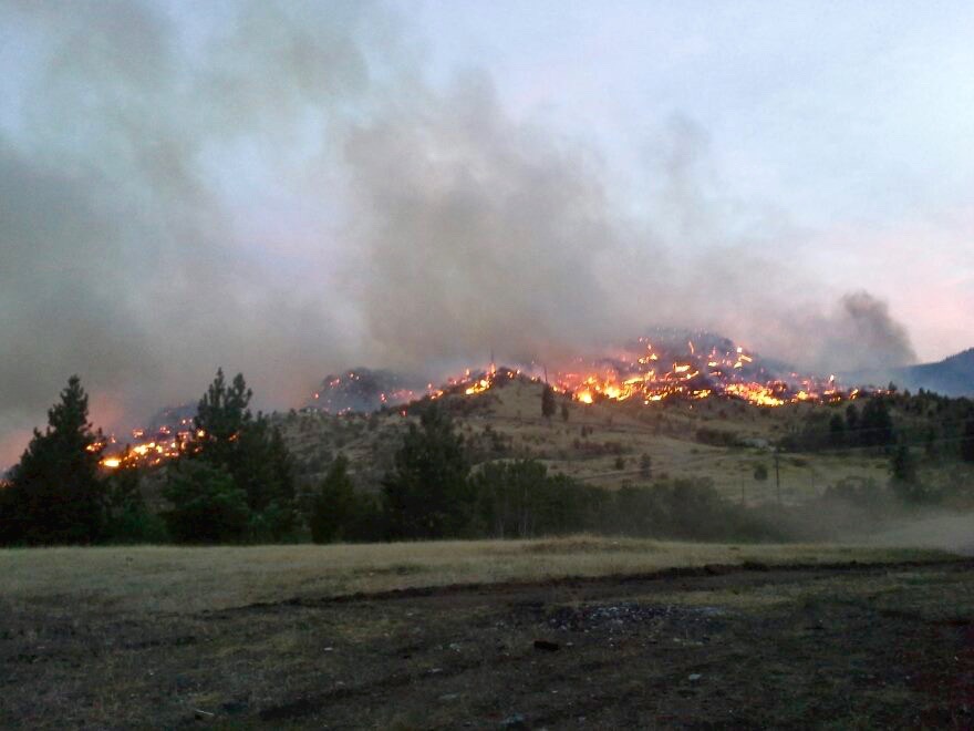
2 new fires sparked by yesterday's storms are currently threatening the South Okanagan town of Oliver, 30 minutes south of Penticton and about 30 minutes north of the US border.

Over 200 homes evacuated. One confirmed to be burned.


Not to mention, a massive 2500 hectare fire east of Osoyoos in the small community of Rock Creek.


Photo Credit: InfoTel, CBC, Global Okanagan, National Post
Reply With Quote Quick reply to this message
 
Old 08-15-2015, 01:25 PM
 
Location: Northville, MI
11,879 posts, read 14,206,770 times
Reputation: 6381
Thankfully, Atlanta will get rain as rest of the country is fried. Highs limited to the upper 80's. Good summer weather.
Reply With Quote Quick reply to this message
 
Old 08-15-2015, 01:49 PM
 
Location: Atlanta
4,439 posts, read 5,519,730 times
Reputation: 3395
Quote:
Originally Posted by Adi from the Brunswicks View Post
Thankfully, Atlanta will get rain as rest of the country is fried. Highs limited to the upper 80's. Good summer weather.
Yeah, it's looking pretty good after tomorrow in the rain department. Hopefully this is the beginning of a wet fall down here.

Even better is the latest NWS forecast for SE Michigan for when I'll be up there:

Quote:
Thursday 08/20 40% / 0 in
Partly cloudy with a chance of showers and thunderstorms. Highs 75 to 79. Chance of rain 40 percent.
Quote:
Friday 08/21 30% / 0 in
Mostly sunny. Highs 77 to 81.
I'm sure not gonna complain about those temps.
Reply With Quote Quick reply to this message
 
Old 08-15-2015, 02:03 PM
 
Location: New Jersey
15,318 posts, read 17,219,445 times
Reputation: 6959
Quote:
Originally Posted by NorthStarDelight View Post
Yeah, it's looking pretty good after tomorrow in the rain department. Hopefully this is the beginning of a wet fall down here.
I think we're getting your weather now. Nonstop sun, highs around 90 F, and a 20% chance of thunderstorms, aka no storms.
Reply With Quote Quick reply to this message
 
Old 08-15-2015, 03:21 PM
 
Location: Alexandria, Louisiana
5,039 posts, read 4,353,305 times
Reputation: 1287
Quote:
Originally Posted by NorthStarDelight View Post
Yeah, it's looking pretty good after tomorrow in the rain department. Hopefully this is the beginning of a wet fall down here.

Even better is the latest NWS forecast for SE Michigan for when I'll be up there:


I'm sure not gonna complain about those temps.
It's looking better here too. It's been a while since I've seen a forecast like this. I was getting sick of seeing those "hot" icons on the NWS forecast.

Attached Thumbnails
Summer 2015 Thread - Northern Hemisphere-untitled2.png  
Reply With Quote Quick reply to this message
 
Old 08-15-2015, 03:36 PM
 
Location: Lexington, KY
12,278 posts, read 9,452,795 times
Reputation: 2763
A nice cluster of thunderstorms has formed despite it being rather dry (86 with a dew point of 58).

Reply With Quote Quick reply to this message
Please register to post and access all features of our very popular forum. It is free and quick. Over $68,000 in prizes has already been given out to active posters on our forum. Additional giveaways are planned.

Detailed information about all U.S. cities, counties, and zip codes on our site: City-data.com.


Reply
Please update this thread with any new information or opinions. This open thread is still read by thousands of people, so we encourage all additional points of view.

Quick Reply
Message:


Over $104,000 in prizes was already given out to active posters on our forum and additional giveaways are planned!

Go Back   City-Data Forum > General Forums > Weather

All times are GMT -6.

© 2005-2024, Advameg, Inc. · Please obey Forum Rules · Terms of Use and Privacy Policy · Bug Bounty

City-Data.com - Contact Us - Archive 1, 2, 3, 4, 5, 6, 7, 8, 9, 10, 11, 12, 13, 14, 15, 16, 17, 18, 19, 20, 21, 22, 23, 24, 25, 26, 27, 28, 29, 30, 31, 32, 33, 34, 35, 36, 37 - Top