Please register to participate in our discussions with 2 million other members - it's free and quick! Some forums can only be seen by registered members. After you create your account, you'll be able to customize options and access all our 15,000 new posts/day with fewer ads.
UPDATE: On November 19, it had become apparent that significant sea ice losses were ongoing in the Arctic. According to the JAXA sea ice monitor, about 140,000 square kilometers of sea ice had been lost over the period of November 16 through 18. As Arctic Ocean ice typically freezes quite rapidly during November, such counter trend losses are highly extraordinary. Now, sea ice in the Arctic, according to JAXA is 995,000 square kilometers below the previous record low set during 2012.
“It’s about 20C [36 degrees Fahrenheit] warmer than normal over most of the Arctic Ocean, along with cold anomalies of about the same magnitude over north-central Asia,” Jennifer Francis, an Arctic specialist at Rutgers University, said by email Wednesday.
“The Arctic warmth is the result of a combination of record-low sea-ice extent for this time of year, probably very thin ice, and plenty of warm/moist air from lower latitudes being driven northward by a very wavy jet stream.”
Francis has published research suggesting that the jet stream, which travels from west to east across the Northern Hemisphere in the mid-latitudes, is becoming more wavy and elongated as the Arctic warms faster than the equator does...
Arctic sea is is slow growing this November because an early PV split sent all the cold air into Siberia
the anomalies in svalbard have been so extreme that the graph for the daily average temperature (1961-1990) barely is visible within the bar-graph for daily maximum and minimum temperatures.
Right now -2.8C at Svalbard Airport, the 61-90 mean for today is -11.7C.
Coldest low the coldest day the last 30 days still warmer than the 61-90 daily mean.
Every month since November 2010 have been warmer than average.
the anomalies in svalbard have been so extreme that the graph for the daily average temperature (1961-1990) barely is visible within the bar-graph for daily maximum and minimum temperatures.
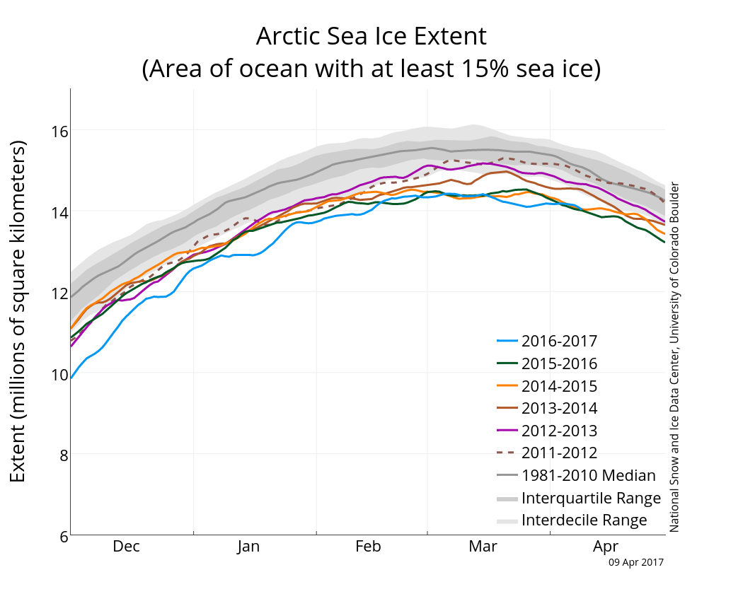
So the Arctic sea ice has begun its retreat for spring and summer after reaching its maximum extent in March. In keeping with recent patterns, sea ice extent is near record lows for the period of satellite data. The record low extent of mid-March was tempered somewhat by extreme cold in the Canadian High Arctic during March allowing the extent to actually grow again towards the end of the month.
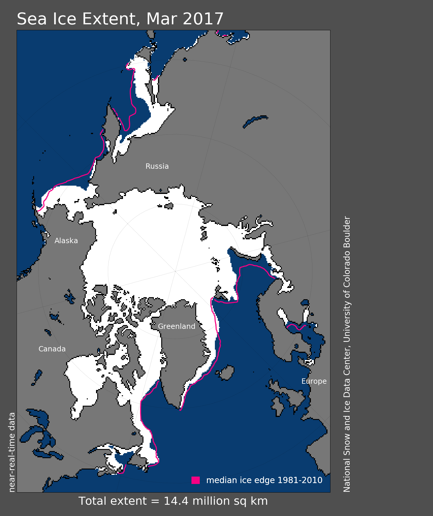
Here's current coverage. As you can see, well below recent medians. The west coasts Svalbard and Severny Island are completely exposed to open ocean.
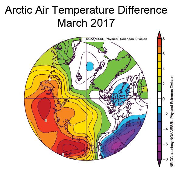
You can see here the March temperature anomalies that reflect the extreme cold in Arctic Canada and Alaska during the month. Of course, this record cold was complimented by well above-average temperatures in Siberia.
The trend for the Arctic in its entirety is for unprecedented warmth. Vize Island (Northern Kara Sea, 79°N 76°E) has a five-month average of 10°C above normal from November to March. To put that in perspective as to how unusual that is consider: if New York City was so anomalously warm during November-March then it would be as warm as Jacksonville Florida. Deep Cold: Interior and Northern Alaska Weather & Climate: Arctic Update
Please register to post and access all features of our very popular forum. It is free and quick. Over $68,000 in prizes has already been given out to active posters on our forum. Additional giveaways are planned.
Detailed information about all U.S. cities, counties, and zip codes on our site: City-data.com.

 Please register to participate in our discussions with 2 million other members - it's free and quick! Some forums can only be seen by registered members. After you create your account, you'll be able to customize options and access all our 15,000 new posts/day with fewer ads.