Please register to participate in our discussions with 2 million other members - it's free and quick! Some forums can only be seen by registered members. After you create your account, you'll be able to customize options and access all our 15,000 new posts/day with fewer ads.
Mistakes and glitches do happen.. I've seen multiple stations here that have gone crazy and have 'recorded' ridiculous temperatures. Many stations also record dew points of -79C.
Mistakes and glitches do happen.. I've seen multiple stations here that have gone crazy and have 'recorded' ridiculous temperatures. Many stations also record dew points of -79C.
Yes but Something like that gets corrected (it better)... something like I posted is not a temporary spike... these temps will make it into the data and increase the averages for the day and month.
A 20 degree spike is different from -79C. Think about it... the entire month will stay above normal because of this most likely and nobody looks back at every single day of temps..... they just look at the monthly averages.
Very interesting, I can't explain that one. There was a 24C/76F 4 am temp here here in mid Oct ( the 14th in fact - sounds like an excuse for a party) a few years ago. It was a very localized event that didn't even make the news 50 km away ( apart from the estimated 1 million + trees knocked over). The cause was Foehn wind following several days of warm weather (also Foehn related ) on the east coast.
Several people around here have told me they saw it reach 27C/80F in town at the same time, and I am inclined to believe them. From memory, the temp was 28C/82F at about 8.00 am.
Coincidentally, a friend of a friend from the States (Boston ) was staying at the time. He said he didn't know NZ got this sort of heat. I had to reply that I didn't either.
It reminds me of a sudden temperature rise that occured here in the same season (last April) and reached 24°C too around midnight. Every weather station in a 50 km radius has recorded a rise, though some more than others.
It reminds me of a sudden temperature rise that occured here in the same season (last April) and reached 24°C too around midnight. Every weather station in a 50 km radius has recorded a rise, though some more than others.
Rozenn, thats a perfect example. Notice it dropped back down to "reality" after a few hours.
This is really concerning the more I research it. I won't even go into how this plays a role in the "warming" debate.. I'm sure we all dont look at charts and data for every station out there every single day. So we're missing a ton of these spikes.
If anyone finds a spike down also, please post here.
Sorry guys... nobody corrected me on this... Thats not a real feel.... That 89 degrees was the day high. . That high goes into a network of temperature data for the area, country and globe..
It is important to note....that no temperature data is official, regardless of source (i.e. coooperative station, awos/asos faa station, etc) until data is published by the NCDC. The NCDC will smooth over any possible errors and correct them to fit a smooth curve. So it is very unlikely that hot temp in Morgantown willl survive in the history books.
We have even seen minor temp changes occur from what occurred versus what was published locally. If the Grand Forks airport had a low of say 3 and the NWS cooperative site had a low of 15 (in town reading)...the end result of what is published in the final records would have the airport at 7 and our office at 11. Smoothing the curve and smoothing out differences...happens all the time.
Dan
Please register to post and access all features of our very popular forum. It is free and quick. Over $68,000 in prizes has already been given out to active posters on our forum. Additional giveaways are planned.
Detailed information about all U.S. cities, counties, and zip codes on our site: City-data.com.

 Please register to participate in our discussions with 2 million other members - it's free and quick! Some forums can only be seen by registered members. After you create your account, you'll be able to customize options and access all our 15,000 new posts/day with fewer ads.


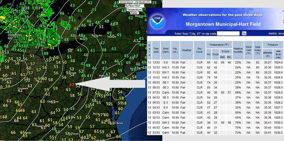

 . That high goes into a network of temperature data for the area, country and globe..
