Please register to participate in our discussions with 2 million other members - it's free and quick! Some forums can only be seen by registered members. After you create your account, you'll be able to customize options and access all our 15,000 new posts/day with fewer ads.
On the NWS Forecast page one can more clearly see the surface level features involved in this pattern that the States have experienced for the past few days and will continue to experience for a short time in the future:
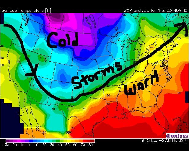
I have filled in the general upper-level pattern that appears to be in place, and I think this sums it up pretty well and matches the departures-from-normal map Cambium posted:
On the NWS Forecast page one can more clearly see the surface level features involved in this pattern that the States have experienced for the past few days and will continue to experience for a short time in the future:
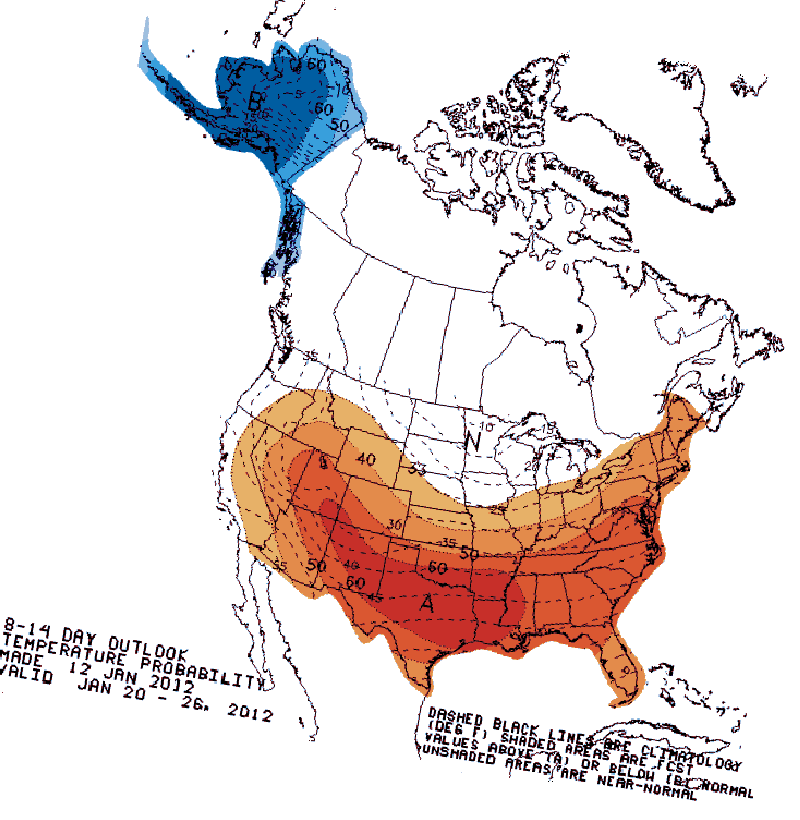
Agreed. However when I mentioned to FWwinters about the pattern...I was not refering to the last few days (or the next few days)...I was refering to the pattern than has dominated North America since last fall...and (roughly) that is this:
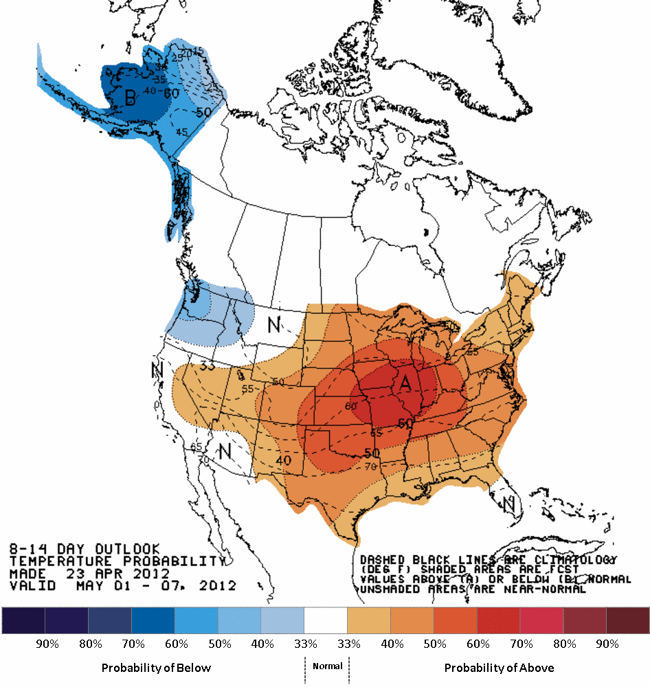
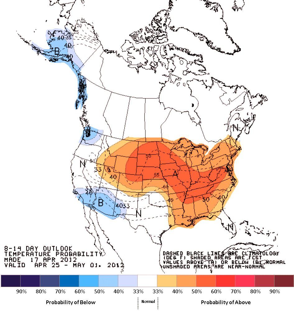
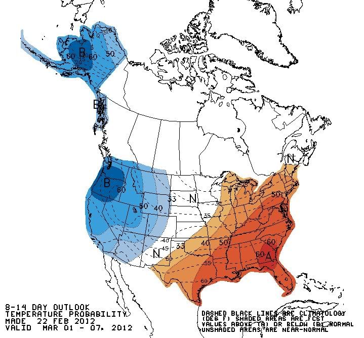
Areas east of the Rockies might see a few below (slightly) normal days this week...but NOAA still seems the ABOVE NORMAL WARMTH for much of the USA to continue right into MAY:
Also, look how accurate NOAA/NWS has been since winter:
Preddictions:
I would not mess with NOAA/NWS they are often right on the money
For their seasonal outlooks CPC/NOAA is one of the worst forecasting outfits I've ever seen in the United States. In 2010 and 2011 they forecast warm winters which turned into cold winters, and in 2011 they forecast a cool summer, which turned into a scorching-hot summer. They also predicted a warm autumn in 2011 which turned into a cool autumn. You'd do pretty well historically to bet on the opposite of what they say. In 2012 they put out their usual warm winter forecast and they were correct, although the axis of warmth was far from where they thought it was going to be. I attribute that to the broken clock effect.
For monthly outlooks, however, they are somewhat better, but even in that arena they are a lot less formidable than you imply.
Also, your map of the (temperature) pattern the U.S. has been in since November is inaccurate. The winter as a whole saw huge warmth anomalies over most of the country, with the biggest centered right on North Dakota and Minnesota, where you had the center of your "cold" region.
Below is a map of departures from normal of DJF 2012. It is vastly different than the pattern on your map would seem to imply, although I will say that your storm track is roughly right, and November and December followed that closely.
As you can see there is huge warmth over most of the country with the main axis in North Dakota and Minnesota, extending southeastward. There were small cool anomalies in the West Coast and New Mexico, but overall the West was close to normal.
Although I will say that your map suffices for a very rough depiction of the pattern since November, but still you could have shifted your cold label further to the southwest. And to be clear I was not intending to respond to your pattern map in the previous post, if that's what you were thinking.
The station closest to my house is only running 3 F above average. Hardly record breaking and it looks like we'll be having a cool end to the month. If the forecast verifies, I expect we'll probably finish very close to average (maybe a degree or two above). The average high from today to April 30th is 62-65 F. The average low is 39-41 F.
This Afternoon: Scattered showers. Mostly cloudy, with a high near 53. Breezy, with a southwest wind around 20 mph. Chance of precipitation is 30%.
Tonight: Isolated showers. Mostly cloudy, with a low around 35. West wind between 7 and 10 mph. Chance of precipitation is 20%.
Wednesday: A chance of showers, mainly between 9am and 11am. Mostly cloudy, with a high near 55. West wind between 8 and 13 mph. Chance of precipitation is 30%. New rainfall amounts of less than a tenth of an inch possible.
Wednesday Night: Partly cloudy, with a low around 35. Calm wind.
Thursday: Showers likely. Mostly cloudy, with a high near 58. Calm wind becoming south between 6 and 9 mph. Chance of precipitation is 70%. New rainfall amounts of less than a tenth of an inch possible.
Thursday Night: A slight chance of showers before midnight. Mostly cloudy, with a low around 37. Chance of precipitation is 20%.
Friday: Sunny, with a high near 56.
Friday Night: Partly cloudy, with a low around 36.
Saturday: Partly sunny, with a high near 53.
Saturday Night: A chance of showers. Cloudy, with a low around 38. Chance of precipitation is 40%.
Sunday: A chance of showers. Cloudy, with a high near 55. Chance of precipitation is 40%.
Sunday Night: A chance of showers. Mostly cloudy, with a low around 39. Chance of precipitation is 30%.
Well here in Fuxton none of the thunderstorms forecast for today appeared, as is quite typical; in fact despite the low barometer it's been very much a fair weather day, albeit on the parky side, which is getting increasingly tedious. But it was an afternoon of decent length sunny spells.
If this occurs then it would continue the current cooling trend relative to normal that has taken hold since midmonth or so. The cool airmasses continue to have much more of a punch than they did in most of March and the first half of April, and as Spring/early Summer progresses it doesn't seem to be getting much warmer in the Eastern interior, at least not until past 10 days out. This is also consistent with what the JMA and a few other forecasts predicted would happen, and that involves an autumn and winter with close to record cold temperatures overall, with conditions averaging colder than normal across the 48 contiguous States.
I sure hope the part in bold turns out to be correct, as I certainly do not want a repeat of last summer and last winter. If next winter turns out as well as the JMA is indicating, perhaps a road trip up to the UP of Michigan would be in order, as I want my snow, and I want it NOW...lol.
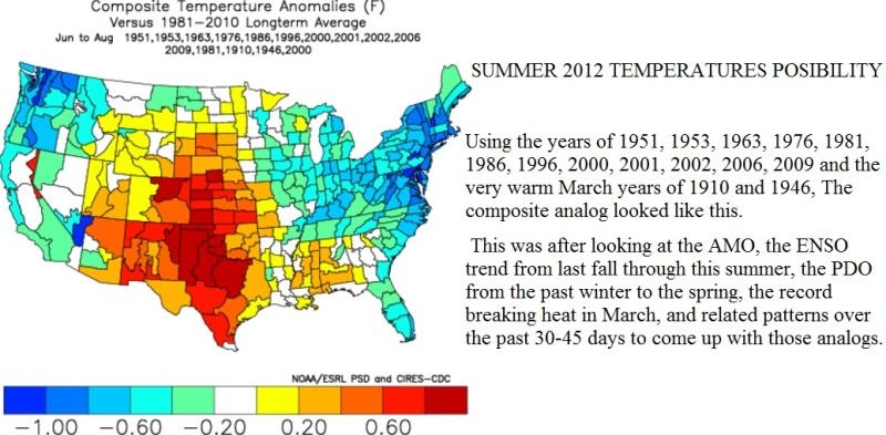
Using those summer analogs, it looks like good news (for someone like me) for the coasts and most of the East, but bad news for Texas. It would be odd if Texas had another near-record hot summer while the East Coast and the Seattle area had record cold.
Quote:
Originally Posted by NorthStarDelight
I sure hope the part in bold turns out to be correct, as I certainly do not want a repeat of last summer and last winter. If next winter turns out as well as the JMA is indicating, perhaps a road trip up to the UP of Michigan would be in order, as I want my snow, and I want it NOW...lol.
Don't pin all of your hopes on that forecast, but early signs look encouraging. I agree that a trip to the U.P. may do you a lot of good in that scenario, and if you're really lucky you'll get some snow at your home base. After all, well below normal conditions are the first prerequisite. January 11, 2011's storm shifted 150 miles to the south would be awesome.
Please register to post and access all features of our very popular forum. It is free and quick. Over $68,000 in prizes has already been given out to active posters on our forum. Additional giveaways are planned.
Detailed information about all U.S. cities, counties, and zip codes on our site: City-data.com.

 Please register to participate in our discussions with 2 million other members - it's free and quick! Some forums can only be seen by registered members. After you create your account, you'll be able to customize options and access all our 15,000 new posts/day with fewer ads.


 Hopefully May will turn out warm as forecasted.