Please register to participate in our discussions with 2 million other members - it's free and quick! Some forums can only be seen by registered members. After you create your account, you'll be able to customize options and access all our 15,000 new posts/day with fewer ads.
Cold weather fans (especially in the Midwest) might be asking where the real cold air has been, and if winter type weather is on the horizon. At this point, the rest of November shows little sign of any really cold air reaching much of the USA beyond the extreme northern Intermountain West. The fast and mostly zonal pattern seems to be developing where there is a front that drags some modestly cold air across the northern tier, then in a few days this stale cold air is swept away as temps once again warm. Most NWS stations seem to be running above normal this November in the north-central USA (upper Midwest)…a sure sign that there has been little cold air on the rest of the mainland. Meteorological winter starts in the Northern Hemisphere on December 1st. It will be interesting to see if this pattern holds through the first month of winter?
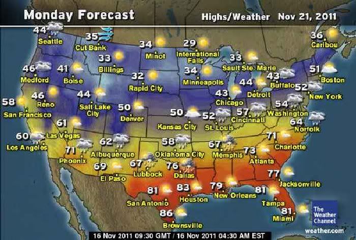
Here is the next 8 days up to Thanksgiving. The temp pattern shows that the trough over the Northwest keeps the cold air over the Intermountain region (highs mostly in the 30’s and 40’s)…with highs in the upper 30's to upper 40’s in the northern tier……the central USA will see temps in the 50’s and low 60’s….while the deep southern tier from the Southwestern deserts through the Gulf/South Atlantic stays warm with highs in the 70’s and 80’s:
^^ Yeah, there seems to be pretty average weather for the next week or so across much of the country. This whole "November blowtorch" stuff is getting blown way out of proportion, imo. People seem to forget that there is an amazing amount of cold air building in Alaska right now, Arctic Village has seen two -40F mornings already over the past 3-4 days, and Fort Yukon was close to -50F this morning. As soon as the pattern shifts (which models show that it will in about 1-2 weeks), I feel like much of the country will experience below normal temperatures.
I see seasonably cool temperatures predicted starting next Tuesday here
I think you’ll see close to normal temps up in your neck of the woods (New England)…but I see little chance of colder than average temps until mid December – if then. What is a little unusual about the pattern so far in the far northern tier (Mt West/Upper Midwest/New England)…is that there have been few days with below normal temps so far this November. Normally, by early/mid November, at least a few times a shot of really cold temps will hit the Northern Plains and the rest of the border states - but not this year so far. The cold temps up in NW Canada/Alaska mean little if the pattern keeps the trough in the Mt West and stays zonal …and that looks to be the case for awhile.
NWS Boston has had only a few days all month when the daily mean temp was below normal. The rest of the month has been normal or well above normal. The last two days where 16 and 17 F above normal in Boston (temps are now running 4.8 F above normal in Boston):
For where I live Nov 1-15 this year has been identical in average (45°) to Nov 1-15 in 2009, which was an unusually warm November. The remainder of November in 2009 stayed just as warm (44°F), which what really made that November warm. I think it will be a hard act to beat November 2009
^^ Yeah, there seems to be pretty average weather for the next week or so across much of the country. This whole "November blowtorch" stuff is getting blown way out of proportion, imo. People seem to forget that there is an amazing amount of cold air building in Alaska right now, Arctic Village has seen two -40F mornings already over the past 3-4 days, and Fort Yukon was close to -50F this morning. As soon as the pattern shifts (which models show that it will in about 1-2 weeks), I feel like much of the country will experience below normal temperatures.
It seems like La Nina's prediction is only applicable to Alaska. The suburbs east of Fairbanks also plummeted to -40 during the past couple of days. Everywhere else in the US had been mostly above the average.
... Record cold temperatures in interior Alaska...
The first cold weather outbreak of the season has settled in over
interior Alaska. Unusually frigid temperatures for mid-November have
been observed across much of the region. Temperatures colder than
40 below zero are being reported in valleys in the central and
northeastern interior. Infrared satellite images also indicate
temperatures under 50 below zero in some of the coldest valley
locations.
Several record low temperatures were broken overnight in the
Fairbanks area. This includes Eielson Air Force Base which
bottomed out at 42 below this morning... shattering the previous
record of 37 below set back in 1956. Record or near record low
temperatures are possible again Thursday morning. The record low for
November 17th at the Fairbanks Airport is 39 below... and 40 below
at Eielson Air Force Base.
Temperatures from 15 to 35 degrees below normal will persist over
much of the interior the next several days. A slight moderation is
expected on the weekend... but temperatures climbing above zero
across interior Alaska are not expected any time soon. Long range
models indicate another shot of reinforcing cold air arriving
early next week... and possibly hanging around into the
Thanksgiving weekend.
The average temperature in Fairbanks this week is around 9 above
with an average low of 7 below zero.
Below is a summary of official low temperatures as of noon
Wednesday unless otherwise noted.
Fairbanks area:
uaf Smith Lake... ... ... ... ... ... ... ... 49 below (unofficial)
North Pole kjnp... ... ... ... ... ... ... ..46 below (new record)
North Pole Woodsmoke subdivision... ... 46 below
Eielson AFB... ... ... ... ... ... ... ... ... 42 below (new record)
Fairbanks Airport... ... ... ... ... ... ... 39 below
uaf West Ridge... ... ... ... ... ... ... ... 37 below (new record)
Something interesting i'd like to share. If you want to check the daily temperature map of the world, go to World High Temperatures Map, it is updated everyday. The coldest spots are the purple that hover over Siberia, parts of Greenland, and Alaska. Looks like the lower-48 is getting some of that cold as the air mass makes its way down south
Please register to post and access all features of our very popular forum. It is free and quick. Over $68,000 in prizes has already been given out to active posters on our forum. Additional giveaways are planned.
Detailed information about all U.S. cities, counties, and zip codes on our site: City-data.com.

 Please register to participate in our discussions with 2 million other members - it's free and quick! Some forums can only be seen by registered members. After you create your account, you'll be able to customize options and access all our 15,000 new posts/day with fewer ads.


 (temps are now running 4.8 F above normal in Boston):

