Please register to participate in our discussions with 2 million other members - it's free and quick! Some forums can only be seen by registered members. After you create your account, you'll be able to customize options and access all our 15,000 new posts/day with fewer ads.
Is it fair to say that walking became impossible? Also, it could be argued that the rail lines surrounding Globeville are more restrictive to pedestrians than the freeways.
OK, maybe I should have said extremely difficult to walk.
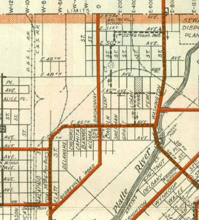
Rail lines do not restrict pedestrians, the way freeways do. Below is a map of the area before the freeway construction. Note that for the most part the rail lines, did not even break the street grid. They were mostly one or two track freight lines, with crossings at every block. Only a minor inconvenience to pedestrians if they happened to get stuck waiting for one of the few freight trains a day going to or from the smelters.
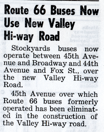
It sucked to be you if you were a bus rider in 1949. Oops, your bus service is gone. Because the street the bus used to run on, no longer exists. I guess you will have to buy a car and drive on the new New Valley Hi-way Road. Soon to be known as I-25.
I'll look at these later. I spent too much time on CD yesterday! Of course, pleasant surroundings enhances the walk. Again, this sounds like wanting no inconvenience whatsoever.
Thinking about this some more, what else is walkabilty other than how convenient walking is? The convenience difference is the point.
We have this crazy intersection near Whole Foods. It isn't very pleasant for anyone, but they did add medians and signal timers to make it easier. You can wait in the middle everywhere. The bike design is terrible though. And the other bikers don't help by riding in the crosswalk.
That doesn't look unpleasant to walk along at all, or to cross the street.
And that bike rider in the picture is running a red light ...
Quote:
Originally Posted by Mircea
Now, if you want to make the argument for I-75 through Dayton, Ohio, you surely can, and your first clue would be as you head south from Tiffin, Ohio, the gigantic friggin' "S" curve that forces you to drop your speed from 75 mph to 20 mph so that you can stay in your lane, without rolling your vehicle and killing everyone in it.
Not sure what you're talking about, since I-75 goes nowhere near Tiffin. That being said, there are plenty of other reasons a highway is located where it is other than any perceived racial reasons.
Quote:
Originally Posted by nei
And some multi-lane intersections can be dangerous; if the roads are fast, multiple lanes of turning traffic who may not have the best of the crosswalk in the distance.
All intersections are dangerous. But there are easy ways to fix them so that everyone is happy. No one user of the road needs to be demonized.
Quote:
Not trying to pick on posters too much, but sometimes I reads like more comments about "hip shops" are posted more by those arguing with the "urbanists" than by those interested in walkable neighborhoods. It reads mostly as stereotype tossing, there's plenty of posts on being able to walk to useful things.
It's what a lot of people on this forum talk about when they discuss "walkable" neighborhoods. The one neighborhood example I was referring to - I think it was Richmond? - in the quoted post looked lovely, but there wasn't a soul on the street, nor were there any of the oh-so-often exalted destinations in sight. Hence the sarcasm.
Quote:
Originally Posted by nei
Sidewalks obviously are important for safety, but they don't give any indication if there's anything in walking distance, as well as some of the factors.
I think it's better to have them to accommodate in a safer manner those who want to walk, rather than not have them at all.
Quote:
Originally Posted by Katiana
Well, we've read a lot of posts about how some people can't just go out and walk w/o something "interesting" such as a coffee shop, bar (lots of emphasis on bars), movie theater, dance club, restaurant, whatever to pass along the way. We've read that an area has to be "interesting" to be considered "walkable". If you could see some of the places I've walked in the day, you'd be shocked. There was a steel mill on the main street of my hometown (not quite in the shopping area). I've walked by it many times on my way to someplace else. And I can just walk around the 'hood and enjoy the scenery w/o having to drop in at a coffee shop, or take my dry cleaning somewhere. The most I can do here in the hood is catch a sermon at the Mormon church!
What she said, except the bit about the Mormon church.
Quote:
Originally Posted by TheCityTheBridge
Blight was not a justifiable reason to use eminent domain (combined with subsequent redevelopment) to clean up a neighborhood until 2005's Kelo v. City of New London (a highly controversial use of eminent domain).
True, but for highway construction - which is seen as a public good - blight was a justifiable reason for eminent domain.
OK, maybe I should have said extremely difficult to walk.
Rail lines do not restrict pedestrians, the way freeways do. Below is a map of the area before the freeway construction. Note that for the most part the rail lines, did not even break the street grid. They were mostly one or two track freight lines, with crossings at every block. Only a minor inconvenience to pedestrians if they happened to get stuck waiting for one of the few freight trains a day going to or from the smelters.
Perhaps because, the rail line is much older, so the neighborhood could be built around the train line in a way that couldn't happen with the highway. Also, an infrequent rail line is very different from a frequent one. There's a rail line going through the center of my town, the intersections near the town center are grade separated. It does take up quite a bit less space than the nearby expressway and much less noisy.
Globeville, the Denver example, is not a black neighborhood; it's currently very majority Hispanic. I have no idea what it was like in 1964; I was in high school in Pennsylvania at the time, never thought I'd live in Colorado.
I don't know what it was like in 1964 either. But when I first explored the area in the mid-1970s, it's was 90%+ young hispanic families, with a few older white residents (senior citizens) mixed in.
Race isn't really that important though. Globeville was always a poor working class neighborhood. The interstates would not have bisected it, if it had been an upscale white neighborhood, like Washington Park or something.
I've got a little history correction here. Blight was not a justifiable reason to use eminent domain (combined with subsequent redevelopment) to clean up a neighborhood until 2005's Kelo v. City of New London (a highly controversial use of eminent domain). Separation was certainly used to divide poor & nonwhite communities from others, but that was primarily done through racially restrictive covenants (until outlawed in the 1960s).
Sorry, that's not correct. Kelo v. New London set the precedent of allowing use of eminent domain without a finding of blight. Many, many neighborhoods were declared "blighted" (a condition that often had little to do with the conditions of buildings), taken via eminent domain, and demolished for redevelopment and highway projects, generally in poor and nonwhite neighborhoods, in the 1950s-1970s.
Quote:
We can certainly speculate about the use of highway and rail construction to separate those communities as well. I would agree that in many cases the effect of such construction was to separate those communities, though I am not so sure that we would find that the intent of the construction was to separate poor and nonwhite communities.
That's why they call it "de facto" segregation rather than "de jure" segregation: it was used in places where "de jure" segregation was illegal, but there were persuasive economic reasons to encourage racial/economic separation. Urban renewal followed the path of least resistance, which also happened to be through poor and nonwhite neighborhoods. The ends justified the means.
That doesn't look unpleasant to walk along at all, or to cross the street.
And that bike rider in the picture is running a red light ...
The crosswalks are pretty indirect. when you let's start on the Whole Foods side, and need to get to Wheel Works, it takes 4 crosswalks (all on different cycles.) So you need to walk, wait, walk, wait. Lots of jaywalking over there because the signal cycle is really annoying. And if you are on the wrong side when the bus comes, you have no hope with the crappy timing.
Also, the bike lane situation is terrible. the bike lane is shared with the turn lane, and people tend to speed through that right turn, into the crosswalk. There isn't enough space for bike riders to wait for the light (which is why i walk mine, it is safer). Which is one reason people run that light pretty often. You can see the traffic for several blocks, and the way the lights are timed, if it goes green while you are in the intersection, there are at least 3 blocks before the cars hit that intersection.
Grr, I hate when bikers run the light. One of my pet peeves. I have nearly been hit enough times by bike riders who sail through lights and stop signs. I stop at all red lights, slow for crosswalks.
Sorry, that's not correct. Kelo v. New London set the precedent of allowing use of eminent domain without a finding of blight. Many, many neighborhoods were declared "blighted" (a condition that often had little to do with the conditions of buildings), taken via eminent domain, and demolished for redevelopment and highway projects, generally in poor and nonwhite neighborhoods, in the 1950s-1970s.
That's why they call it "de facto" segregation rather than "de jure" segregation: it was used in places where "de jure" segregation was illegal, but there were persuasive economic reasons to encourage racial/economic separation. Urban renewal followed the path of least resistance, which also happened to be through poor and nonwhite neighborhoods. The ends justified the means.
On further review, you are right and I am wrong on the history.
I've got a little history correction here. Blight was not a justifiable reason to use eminent domain (combined with subsequent redevelopment) to clean up a neighborhood until 2005's Kelo v. City of New London (a highly controversial use of eminent domain). Separation was certainly used to divide poor & nonwhite communities from others, but that was primarily done through racially restrictive covenants (until outlawed in the 1960s).
We can certainly speculate about the use of highway and rail construction to separate those communities as well. I would agree that in many cases the effect of such construction was to separate those communities, though I am not so sure that we would find that the intent of the construction was to separate poor and nonwhite communities.
Exactly! We shouldn't get too caught up in these conspiracy theories.
Quote:
Originally Posted by KaaBoom
OK, maybe I should have said extremely difficult to walk.
Rail lines do not restrict pedestrians, the way freeways do. Below is a map of the area before the freeway construction. Note that for the most part the rail lines, did not even break the street grid. They were mostly one or two track freight lines, with crossings at every block. Only a minor inconvenience to pedestrians if they happened to get stuck waiting for one of the few freight trains a day going to or from the smelters.
It sucked to be you if you were a bus rider in 1949. Oops, your bus service is gone. Because the street the bus used to run on, no longer exists. I guess you will have to buy a car and drive on the new New Valley Hi-way Road. Soon to be known as I-25.
If you read my link, there was only one streetcar stop NEAR Globeville, and none within it. Jeez, I even posted that, you didn't even have to open the link! You posted that undated link, that talks about bus service to the stockyards. IIt's not clear that changing the routes was a total inconvenience, as they maintained the bus service, just routed it a different way, apparently over an overpass. Bus service was not gone, as you assert.
That's funny, the rail lines didn't even break the grid! Do you think people actually walked across the rail lines? Do you think there were sidewalks every block crossing the tracks? I. . . don't. . . think. . . so! How do YOU know it was only a few trains a day?
Quote:
Originally Posted by nei
Thinking about this some more, what else is walkabilty other than how convenient walking is? The convenience difference is the point.
Walkability seems harder to define than suburb, so don't ask me to do it! If you HAVE to walk, b/c you don't have a car, you look for the shortest way to get somewhere. Convenience helps. But it's not everything. Now if you're walking b/c you want to, to make a statement, or whatever, and the car is home in the driveway/garage, you might want more "entertainment" and nice views along your route.
Perhaps because, the rail line is much older, so the neighborhood could be built around the train line in a way that couldn't happen with the highway. Also, an infrequent rail line is very different from a frequent one. There's a rail line going through the center of my town, the intersections near the town center are grade separated. It does take up quite a bit less space than the nearby expressway and much less noisy.
That is correct. The examples given in the map images actually showed the railroad lines along the western boundary of Globeville. The rail lines inside the neighborhood are like the ones below. Hardly anything that would impact people from walking. A big difference from two 20 foot high sound walls with six lanes of freeway traffic in between them .
Please register to post and access all features of our very popular forum. It is free and quick. Over $68,000 in prizes has already been given out to active posters on our forum. Additional giveaways are planned.
Detailed information about all U.S. cities, counties, and zip codes on our site: City-data.com.

 Please register to participate in our discussions with 2 million other members - it's free and quick! Some forums can only be seen by registered members. After you create your account, you'll be able to customize options and access all our 15,000 new posts/day with fewer ads.