Sunspot, New Mexico (Grants, Carrizozo: design, area, recreation)
Please register to participate in our discussions with 2 million other members - it's free and quick! Some forums can only be seen by registered members. After you create your account, you'll be able to customize options and access all our 15,000 new posts/day with fewer ads.
If you like lava and are ever in central Oregon, here is a Youtube I did a couple of years ago of McKenzie Pass.
I doubt that most people who have never visited the NW states realize the extent of the basaltic formations known generally as the "Columbia River Basalt Group." I am fascinated by the "columnar basalt" formations in cliff faces of the area. Here is a good introduction for anyone who is curious:
A word of warning...for anyone passing through the Valley of Fires on US-380 and thinking about making a quick stop and hike into the lava. It's an extremely dangerous lava that can cut to the bone in an instant if putting down a hand to brace oneself - or to break a fall. It will rip right through a good pair of leather hiking boots if not careful. And a good sturdy pair of boots is a must for walking around on the lava.
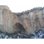
El Malpais is yet another destination on my list. There is so much to see in New Mexico!
Unrelated, but for those who have experienced these flows, it is easier to imagine the terror of the Army soldiers during the Modoc War near Tule Lake, California, in 1872-73 when the Modocs ambushed a company at what is called the Thomas-Wright Battlefield and sent them fleeing in terror over the rough lava to return to the main camp.
If anyone is interested, this is a fine account:
1872-73 when the Modocs ambushed a company at what is called the Thomas-Wright Battlefield and sent them fleeing in terror over the rough lava to return to the main camp.
There are similar accounts about the Valley of Fire lava field and fleeing local Indian bands that knew a "secret" passageway through the flow. Chasing troopers were chagrined when they showed up on the far side of the flow, thumbing their noses (or whatever they did in those days).
A word of warning...for anyone passing through the Valley of Fires on US-380 and thinking about making a quick stop and hike into the lava.
I found this old photo of US-380 crossing the lava flow at Valley of Fires. The view is looking east. The town of Carrizozo can be seen on the other side of the lava field, with the Sacramento Mountains beyond that.
I shredded a good pair of hiking boots at Malpais. It is an amazing place but it will take a toll on you.
Lava field...Malpais
Last trip out I let the grand daughter pick the next hike. Of all the places we have hiked she picked The Malpais again! So anyway besides the tarantula we got to watch some guy take off for the cairns in flip flops.
Great post, Threecats. It looks like a lot of the lava at Valley of Fires is pahoehoe. It is the aa lava that is nearly impossible to traverse safely. Wonder how quickly the guy in flip-flops bled out.
Please register to post and access all features of our very popular forum. It is free and quick. Over $68,000 in prizes has already been given out to active posters on our forum. Additional giveaways are planned.
Detailed information about all U.S. cities, counties, and zip codes on our site: City-data.com.

 Please register to participate in our discussions with 2 million other members - it's free and quick! Some forums can only be seen by registered members. After you create your account, you'll be able to customize options and access all our 15,000 new posts/day with fewer ads.