Please register to participate in our discussions with 2 million other members - it's free and quick! Some forums can only be seen by registered members. After you create your account, you'll be able to customize options and access all our 15,000 new posts/day with fewer ads.
A follow on to the “Glendale Train” that Jesse James robbed on more than one occasion.
I mentioned Glendale Gardens as a subdivision east of the 35th and Phelps Road area.
Also in that area is the 95-acre Glendale Park and one edge of that park runs partly along Crackerneck Road. I cannot help but think area is the secluded place where Sharon Kinne dumped her second murder victim.
Glendale Gardens began construction in the early 1960s and Glendale Park came along later.
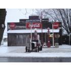
Selsa at one time was called Glendale as shown on some old Chicago & Alton Railroad maps.
The town changed its name to Selsa supposedly because of the frequent James Brother’s train robberies.
Below is a photo of the Selsa railroad depot where the last passenger train on the Gulf, Mobile, and Ohio, the former Chicago & Alton line, was stopped and the passengers “robbed” in 1961. The station was about one mile from the tip of Glendale Park following the rail line.
The Swope murders occurred at Walnut and Pleasant in the Swope Mansion in 1909. At the time, the huge house was conveniently on an intercity trolley line going from Independence to Kansas City. The trolley turned on Walnut going down Pleasant and then turned on Lexington going to the square.
The first victim dying of mysterious circumstances was Thomas Swope the man after whom Swope Park in Kansas City was named. In fact he donated the two thousand acres or so the park sits on.
Swope was filthy rich but did not own the three story, twenty-six room mansion. He only roomed there, as did a number of relatives. His sister-in-law, Maggie Swope, owned the house and grounds after the death of her husband, Thomas Swope’s rich brother. Maggie Swope’s maiden name was Chrisman—she was the daughter of William Chrisman.
Two more occupants died under mysterious circumstances. Several others were mysteriously poisoned. The charged culprit was a doctor from Kansas City who had married Maggie Swope’s daughter against Maggie Swope’s wishes and he presumably wanted Thomas Swope’s inheritance via his new wife. He was allegedly trying to eliminate all the other heirs one by one. He was tried but was not ultimately convicted.
The Ott & Mitchell funeral home handled Thomas Swope’s burial. Right now I am thinking that place is on south Noland Road but it has not always been there. I believe it moved there at least fifty years ago from another location—maybe the Englewood area?
The Swope mansion was opened as a spook house on Halloween nights when I was young, but I never went in there. The house was torn down in 1960.
Pypers Place was a drive in restaurant with car hops located on 23rd Street west of Main Street at the railroad tracks.
Pypers was locally famous for its pork tenderloin sandwiches and curly Q fries. Those tenderloins remain the best I have ever eaten. In fact I have never come across an equivalent type sandwich.
They also had “crumbly” hamburgers, which I did not enjoy and fountain cherry cokes, which I did. They also offered a brain sandwich, which I never wanted to try.
Although this was a great place to eat, teenagers did not exactly knock down the door to get there on a regular basis because of the prices. It was more of an upscale place that you patronized when you could.
When I first started going there, the price of a tenderloin sandwich was 35 cents. This was at a time when you could get a hamburger at the Golden Point Drive In for ten cents. (There were no McDonalds in Independence yet). When the tenderloin went to fifty cents, I had to cut down my patronage. Money did not flow then like it seems to do today.
As part of the widening of 23rd Street to four lanes around 1960 or so, a bridge was constructed over the tracks. This wiped Pypers Place out but they relocated to just past 23rd and Sterling near Hill Park.
A few years later, the place was sold and renamed Clem’s. Clem’s retained the carhops and those great tenderloins, but that place is now closed. Something is wrong with the building safety and the city of Independence closed it down.
Division I and Division II, William Chrisman High School
In the fifties, the Independence school district had one junior high school with the bland name of Independence Junior High and one high school, William Chrisman. The two school buildings stood one to two blocks from each other close to the business district. Junior high consisted of grades 7, 8, and 9. William Chrisman held grades 10, 11, and 12. Both schools were overflowing. Neither of those schools had a cafeteria. The junior high kids brought their lunch or walked across the street and ate in a cafeteria in the basement of the memorial building. William Chrisman kids patronized the local businesses or brought their lunch.
The school district built the first phase of the new William Chrisman High School on Noland Road from the proceeds of an $800,000 bond issue voted by the public. The first year of operation was the 1957-58 school year but the new school was not large enough to hold the envisioned four grades and thus held only juniors and seniors.
The district rehabbed the old Ott elementary school building and incorporated it into the new school when it opened. A new Ott elementary school was constructed further north on Noland.
One of the features of the new WCHS was a theater in the round. I never learned who came up with this idea or why. The theater was small, though, and might have seated only 300. During preparation for senior graduation, it was necessary to have the seniors congregate in that theater in two different sessions because there was no auditorium. Due to the lack of an auditorium, all-school assemblies were held in the gym.
The building on Noland Road housing the juniors and seniors was known as WCHS Division I.
The old school on Maple Street housing sophomores and freshman was known as WCHS Division II.
I don’t know when the district abandoned the old school or the Division I and Division II concept, but the Community of Christ Church (formerly RLDS) now owns the old Maple Street building. Looking back, I guess the district knew what they were doing back then by relocating WCHS in the north part of town. A few years later Truman High School was located in the south. Now Van Horn is in the district in the west. The old junior high was renamed Palmer Junior High and was subsequently abandoned as a school. Part of that building now houses school district offices. The other part may become a senior citizen effort of some type.
There were a few days after school that I would have to drive from Division I to Division II to pick up my younger sister. I would always go via US Highway 24 and exit at the Truman Library. I would then turn left on Delaware Street and drive under the 24 bridge and head straight for the Truman home and then to Division II, which was less than a block away. I would always honk my horn going under the 24 highway overpass. That horn was loud and the shape of the overpass made the sound reverberate creating a very much louder sound. The noise would even startle anyone riding with me.
One day I honked and then heard a honk in response. I looked around and on the other side under the over pass former President Harry S Truman was sitting there by himself in his 1957 Chrysler. He was smiling and waving at us. My girlfriend and I frantically waved back as we passed him. This was in the days of no Secret Service protection and he did not have Mike Westwood, his bodyguard, with him.
Missouri Water Company and a Momument Across the Street
The Missouri Water Company offices were located on the southeast corner of Kansas and Liberty streets one block south of the square. We paid our water bill there in cash and coin in the times when there was little or no mailing of payments.
The Missouri Water Company served Independence and University City, Missouri, near St. Louis. It was a private company pumping water for Independence from the Missouri River. I seem to recall 4 million gallons a day was being pumped from the Missouri in the mid-fifties but the river was becoming more and more polluted.
The city of Independence bought the utility a number of years ago and today gets about 30 million gallons a day of clear water from a huge river running underneath the Missouri River. The well pumping area is out by the Liberty Bridge on Missouri 291.
Catty cornered across from the Missouri Water Company was a store that I cannot remember. It might have been a filling station or a tire store.
However, on site was a large stone monument commemorating something from the trail days, perhaps a wagon manufacturing place?
Can anyone recall what the stone monument commemorated and if it is still there?
Two of the shortest highways in the state run through Independence, Missouri.
Missouri Highway 12 starts at I-435, follows Truman Road and ends at Spring Street two blocks west of the square, a distance of five miles.
In the old days, the highway split off from Truman Road at about River Boulevard and followed Maple Street passing the square and ending on Maple where Snows Meats was located behind the Katz drug store.
Missouri Highway 78 starts at I-435 and follows 23rd Street all the way out to Missouri Highway 7 at the Lake City Arsenal, a distance of eighteen miles. In the old days, that highway started at Van Brunt Boulevard in Kansas City.
In the fifties, Bostian Chevrolet on west Maple, Moody Motors Ford on west Lexington, and Galen Boyer Pontiac-Cadillac on west Maple, was some of the automobile dealers located in the Independence business district surrounding the square.
There was a Hudson dealer on south Liberty across from the A&P Supermarket. That dealer never recovered from a disastrous fire in the late forties or early fifties. My father worked at that A&P and in the late evening he received a call from the night stockman that the dealer was on fire. We drove up to the A&P parking lot and watched the building burn. There were other buildings involved also and all the buildings from the alley entrance behind the First National Bank (now Bank of America) south to Kansas Street burned.
A Dodge dealer was on west Maple across from the Granada Theater.
There was a Blue Valley Studebaker in Independence but I cannot recall the location. Our next door neighbor purchased a new ’53 Studebaker. He also drove a Nash Ambassador.
Across Truman Road from the fire station was Cable Chevrolet. I am not sure who owned it before him. Bostian might have moved there from Maple Street. Cable later moved to a location on south Noland.
There had to be other dealers in the uptown business district area also.
There was a large Chevrolet dealer on Independence Avenue in the Fairmount shopping area.
Nash automobiles were sold on Winner Road in Englewood within very close proximity to the Englewood Theater. When Nash and Hudson merged in 1955 to form American Motors that dealer sold Nash, Hudson, Metropolitan, Rambler, Marlin, Pacer and Gremlin. Even with American Motors struggling to stay alive, this dealer lasted quite a while and may have even moved to a location on 40 Highway in the sixties. American Motors did not vanish until 1988.
A Kaiser-Fraser dealer was at Walnut and Main just across from the Gas Company. That dealer sold Kaisers, Frasers, and Henry J’s. Fraser’s were supposed to have been an upscale automobile. I think the dealer lasted into the early 50’s. Kaiser-Fraser Automobile Corporation became Kaiser Automobile and then vanished in 1955.
When Noland Road expanded to four lanes in the early sixties, there was a mass migration of car dealers from the uptown area and elsewhere to the “miracle mile” on Noland Road. Galen Boyer (Junior, also WCHS ’59) is still there.
Someone previously mentioned their favorite soda pop and who could talk about old Independence without Polly’s Pop being a subject?
The Polly’s Pop plant was six blocks directly west of the square. Polly Compton purchased the bottling facility on River Boulevard starting in 1923, but the building had been producing soda beverages since 1905. With Polly’s ownership, the company logo was a large parrot on a bird cage swing holding a bottle of Polly’s Pop. The plant was in an area where a spring provided free water for the beverage.
It was the best soda pop in the world as far as I was concerned. Nehi did not compare. Black Cherry was my favorite. They also produced a cola flavor but I did not think it compared to Coca Cola. Other flavors were cherry, grape, orange, strawberry, root beer, two colors of cream, lemon, and others. I cannot help believe that the fruit flavoring was from real fruit rather than from artificial stock.
Polly’s pop came in six ounce and twelve ounce bottle sizes. I want to say that the six ounce bottle sizes were five cents and the 12 ounce bottles were ten cents—from the cooler plus two cent deposit for the bottle. I cannot recall what the six pack take home size cost—but probably 29 cents for the six ounce size plus fifteen cents deposit.
Pepsi Cola in twelve ounce bottles was only five cents. So Polly’s competed not only against Coca Cola but also against a cheaper Pepsi. Pepsi’s radio jingle pushed its value compared to other sodas: "Pepsi-Cola hits the spot / Twelve full ounces, that's a lot / Twice as much for a nickel, too / Pepsi-Cola is the drink for you" Pepsi even beat Coca Cola in price, which sold six ounces for five cents.
Polly was also the local distributor for Goetz beer, the St Joseph and Kansas City brewers of Country Club beer. Polly’s went out of business in 1967 having never been able to switch to cans. The bottling plant was subsequently torn down and the area became open space in 1980. The area is now the site of Polly’s Pop Park, a two-acre city facility.
One of my jobs at the C&J United Super Market was to sort returned bottles in a flimsy shed attached to the back of the store building. Deposit and return of bottles was a huge effort in the fifties. Polly’s pop branded bottles reportedly cost Polly ten cents to acquire but the deposit was only two cents (three cents for the cardboard six bottle carrier) and people were slow to return the bottles.
Polly’s sold more soda in our store than Coca Cola or Pepsi Cola and the bottle returns took up the largest space over the national brands. Coca Cola was available only in six ounce bottles and did not sell as well in our store but was more popular in the area overall because of fountain sales.
During the summer, one of the problems with Polly’s returned bottles was that mice, attracted by the dried flavoring in the bottom of the returned bottles, would manage to climb up to the top of the bottle and then slide inside trying to get at the sweet stuff. The mouse could not get out and would expire. By the time the Polly’s Pop truck made its once per week trip to the store, the bottle would be smelling really bad. This was not an epidemic but was frequent. Additionally, customers would drop their cigarette stubs into the empty bottles. How, the bottler handled these problems I do not know.
As I am writing this, one may buy an empty Polly’s Pop bottle on EBay for $29.99 on up to $59.99 each. A full bottle is probably worth much more.
A Polly’s Pop ten by thirteen inch metal sign is offered on EBay for $129.99.
The Swope murders occurred at Walnut and Pleasant in the Swope Mansion in 1909. At the time, the huge house was conveniently on an intercity trolley line going from Independence to Kansas City. The trolley turned on Walnut going down Pleasant and then turned on Lexington going to the square.
The first victim dying of mysterious circumstances was Thomas Swope the man after whom Swope Park in Kansas City was named. In fact he donated the two thousand acres or so the park sits on.
Swope was filthy rich but did not own the three story, twenty-six room mansion. He only roomed there, as did a number of relatives. His sister-in-law, Maggie Swope, owned the house and grounds after the death of her husband, Thomas Swope’s rich brother. Maggie Swope’s maiden name was Chrisman—she was the daughter of William Chrisman.
Two more occupants died under mysterious circumstances. Several others were mysteriously poisoned. The charged culprit was a doctor from Kansas City who had married Maggie Swope’s daughter against Maggie Swope’s wishes and he presumably wanted Thomas Swope’s inheritance via his new wife. He was allegedly trying to eliminate all the other heirs one by one. He was tried but was not ultimately convicted.
The Ott & Mitchell funeral home handled Thomas Swope’s burial. Right now I am thinking that place is on south Noland Road but it has not always been there. I believe it moved there at least fifty years ago from another location—maybe the Englewood area?
The Swope mansion was opened as a spook house on Halloween nights when I was young, but I never went in there. The house was torn down in 1960.
I wish I would have been around for that.
Please register to post and access all features of our very popular forum. It is free and quick. Over $68,000 in prizes has already been given out to active posters on our forum. Additional giveaways are planned.
Detailed information about all U.S. cities, counties, and zip codes on our site: City-data.com.

 Please register to participate in our discussions with 2 million other members - it's free and quick! Some forums can only be seen by registered members. After you create your account, you'll be able to customize options and access all our 15,000 new posts/day with fewer ads.