Please register to participate in our discussions with 2 million other members - it's free and quick! Some forums can only be seen by registered members. After you create your account, you'll be able to customize options and access all our 15,000 new posts/day with fewer ads.
1. NYC is by far and away number 1 - it just feels massive, and is the only US city that can compare to cities like Tokyo, Istanbul, or London, in terms of "big city" feel.
Then you have a huge drop - not to discredit other cities or say NYC is the best city, but when it comes to "big city" feel, no other city in the country is even in the same realm.
Then comes 2A. Chicago and 2B. Los Angeles. Both feel like big cities in very different ways, but people really understate just how massive and buzzing LA actually is. It's a totally different model for a city (and not my personal favorite) but you can't deny you feel like you are in a massive built-out megolopolis when you're in LA. Chicago also feels huge, in a more traditional big city way.
Next, I would put 3. San Francisco. Sure, it's only 7 X 7 miles, but the downtown and inner neighborhoods are huge, crowded, and bustling, and even some of the outer neighborhoods feel incredibly vibrant. Structurally and population-wise, it's really dense, and its urban fabric is incredibly consistant and strong. In SF, you truly feel like you are in a "city" almost anywhere you go.
After that comes 4. Boston and 5. Philly. Boston is in many way similar to SF, but it has a more quaint feeling and doesn't have quite as many nodes of activity. As for Philly, I think it's a great city with a very vibrant downtown (i.e. Center City) and some bustling neighborhoods - but it just doesn't quite have the "big-city" feel the others on this list do. There are too many areas that feel relatively quiet and it's somehow missing the energy that even smaller cities like Boston and SF have. In that way, it has slightly less of a big-city feel, but only slightly.
So the list is:
1. NYC 2A. Chicago 2B. LA 3. San Francisco 4. Boston 5. Philly
1) New York
2) Los Angeles
3) Chicago
4) Atlanta/Houston (Tie)
6) Dallas
7) Philadelphia
8) Detroit
9) Phoenix
10) San Francisco Bay
11) Miami
12) DC
13) Seattle
14) Minneapolis/St. Paul
15) St. Louis (metro feels much larger than actual size)
16) San Diego
17) Boston (metro feels much smaller than actual size)
18) Tampa/St. Petersburg
19) Orlando
20) Denver
8-tied Atlanta 8-tied Detroit 8-tied Houston 8-tied Miami 8-tied Philadelphia
I am surpirsed so many people feel Boston is larger than Philly and honestly even more surprised that you reference the CSA as feeling less spread, especially including PVD. PVD is like 30 some miles; within that distance you leave the CSA of Philly in the most populated area. Overall that just really surprises me. I wonder how many people base this perception on traversing the NJ turnpike from NYC; that image gives a strangly small perception of Philly and misses the urban footprint to a great extent.
People who haven't been or have barely spent time in LA think that because LA sprawls, it doesn't have a "big city feeling" to it, which I can assure you is patently untrue. How many people here have heard of the Westwood District? Outside of Socal residents and frequent visitors, probably none. Well, it looks like this...
There are areas that look like this all over Los Angeles. There are numerous clusters of skyscrapers to be found all over the city, outside the downtown core. There's nothing about LA that isn't "big city."
Yep, and between many of those clusters are high density residential developments, with five and six story buildings clumped together. L.A. is plenty dense, plenty urban, and will soon have one of the largest rapid transit rail networks in the country. People get fooled by things like the Santa Monica mountains and SF valley which radically drop the average density.
I am surpirsed so many people feel Boston is larger than Philly and honestly even more surprised that you reference the CSA as feeling less spread, especially including PVD. PVD is like 30 some miles; within that distance you leave the CSA of Philly in the most populated area. Overall that just really surprises me. I wonder how many people base this perception on traversing the NJ turnpike from NYC; that image gives a strangly small perception of Philly and misses the urban footprint to a great extent.
I understand that but its just that I know pretty much where the NY/Philadelphia border is and when I drive through it I tell myself okay, now Im in NY or okay, now Im in Philadelphia.
When I visited my sister from NJ, I always found myself doing that. Just like whenever I traverse the SF/Sac border.
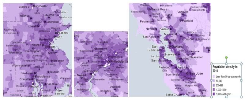
Here are Boston and Philadelphia and SF To Scale:
The Bay Area appears to have a substantially larger area of 5,000+persons-per-square-mile than anywhere except NY, LA and Chicago.
Boston appears to have a much wider area of influence than Philadelphia.
Also, The driving distances in Boston and SFs major Metro population centers are way farther apart than in Philadelphia:
Santa Rosa, CA to San Jose, CA: 106 Miles
Manchester, NH to Providence, RI: 103 Miles
Trenton, NJ to Wilmington, DE: 62 Miles
These factors helped me make my personal ranking. Others may come up with their own methodology.
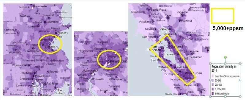
Just to elaborate more on the Bay Area having a far larger area of 5,000+ppsm than Boston and Philadelphia which contributes to my opinion that it feels larger, I made this map to illustrate the extent of the concentration of that density threshold in each CSA. Also the Bay itself creates a huge barrier between the Bay's 2 West and East side so each shoreline has its own long distance area of 5,000+ppsm.
I understand that but its just that I know pretty much where the NY/Philadelphia border is and when I drive through it I tell myself okay, now Im in NY or okay, now Im in Philadelphia.
When I visited my sister from NJ, I always found myself doing that. Just like whenever I traverse the SF/Sac border.
Here are Boston and Philadelphia and SF To Scale:
The Bay Area appears to have a substantially larger area of 5,000+persons-per-square-mile than anywhere except NY, LA and Chicago.
Boston appears to have a much wider area of influence than Philadelphia.
Also, The driving distances in Boston and SFs major Metro population centers are way farther apart than in Philadelphia:
Santa Rosa, CA to San Jose, CA: 106 Miles
Manchester, NH to Providence, RI: 103 Miles
Trenton, NJ to Wilmington, DE: 62 Miles
These factors helped me make my personal ranking. Others may come up with their own methodology.
Fair enough though the Jersey side will make it feel smaller, also oddly crossing the border is not like all of the sudden you have entered some new land. It is odd as because the NY job centers (even in Jersey) have a huge draw, many people that are the counties in the NY MSA still consider themsleves to be affiliated with Philly but central Jersey becomes a grey area where people kind of associate with both cities as they can be within an hour of both Actual downtowns
Here is an image of the border, like some other areas the development doesnt stop, also the Jersey Turnpike is pretty far East of the developed belt that connects the areas
Just to elaborate more on the Bay Area having a far larger area of 5,000+ppsm than Boston and Philadelphia which contributes to my opinion that it feels larger, I made this map to illustrate the extent of the concentration of that density threshold in each CSA. Also the Bay itself creates a huge barrier between the Bay's 2 West and East side so each shoreline has its own long distance area of 5,000+ppsm.
It would be interesting to see what happens if you exclude the bay itself from the SF map. What is the area size of 5,000 ppm occupied land on each map? Also, I'd wonder what happens when you go to, say 10,000 ppm.
It would be interesting to see what happens if you exclude the bay itself from the SF map. What is the area size of 5,000 ppm occupied land on each map? Also, I'd wonder what happens when you go to, say 10,000 ppm.
Agree on the 10K, 5K is a developed measure but not really city so to speak
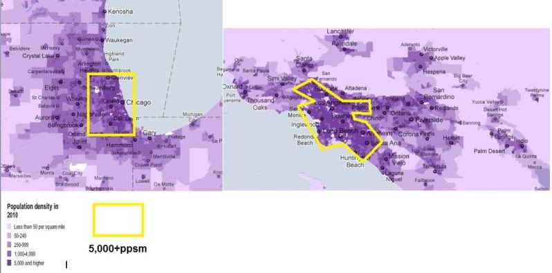
Here is a map of of Chicago and LA to Scale with their main 5,000+ clusters outlined(sorta):
Please register to post and access all features of our very popular forum. It is free and quick. Over $68,000 in prizes has already been given out to active posters on our forum. Additional giveaways are planned.
Detailed information about all U.S. cities, counties, and zip codes on our site: City-data.com.

 Please register to participate in our discussions with 2 million other members - it's free and quick! Some forums can only be seen by registered members. After you create your account, you'll be able to customize options and access all our 15,000 new posts/day with fewer ads.