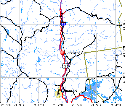
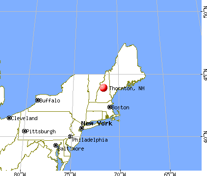
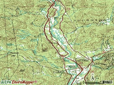
Thornton, New Hampshire
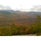
Thornton: From Welch/Dickie mountain!
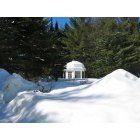
Thornton: Winter scene!
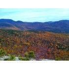
Thornton: Fall foliage!

Thornton: A great walk!

Thornton: Luna Moth (Actias luna)
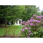
Thornton: Beautiful summer!
- add
your
Submit your own pictures of this town and show them to the world
- OSM Map
- General Map
- Google Map
- MSN Map
Population change since 2000: +35.1%
| Males: 1,251 | |
| Females: 1,239 |
| Median resident age: | 45.5 years |
| New Hampshire median age: | 43.9 years |
Zip codes: 03223.
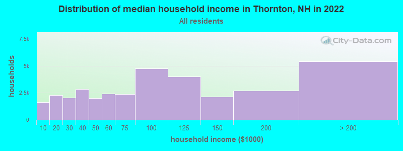
| Thornton: | $75,041 |
| NH: | $89,992 |
Estimated per capita income in 2022: $42,019 (it was $18,478 in 2000)
Thornton town income, earnings, and wages data
Estimated median house or condo value in 2022: $330,809 (it was $103,500 in 2000)
| Thornton: | $330,809 |
| NH: | $384,700 |
Mean prices in 2022: all housing units: $486,096; detached houses: $533,852; townhouses or other attached units: $375,744; in 2-unit structures: $230,260; in 3-to-4-unit structures: $242,363; in 5-or-more-unit structures: $588,257; mobile homes: $127,035
Detailed information about poverty and poor residents in Thornton, NH


- 2,41897.1%White alone
- 291.2%Two or more races
- 220.9%Hispanic
- 120.5%Asian alone
- 40.2%Other race alone
- 30.1%American Indian alone
- 20.08%Black alone
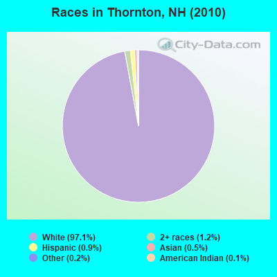
Races in Thornton detailed stats: ancestries, foreign born residents, place of birth
According to our research of New Hampshire and other state lists, there were 3 registered sex offenders living in Thornton, New Hampshire as of July 03, 2024.
The ratio of all residents to sex offenders in Thornton is 830 to 1.
The ratio of registered sex offenders to all residents in this city is lower than the state average.
Type |
2009 |
2010 |
2011 |
2012 |
2013 |
2014 |
2015 |
2016 |
2017 |
2018 |
2019 |
2020 |
2021 |
2022 |
|---|---|---|---|---|---|---|---|---|---|---|---|---|---|---|
| Murders (per 100,000) | 0 (0.0) | 0 (0.0) | 0 (0.0) | 0 (0.0) | 0 (0.0) | 0 (0.0) | 0 (0.0) | 0 (0.0) | 0 (0.0) | 0 (0.0) | 0 (0.0) | 0 (0.0) | 0 (0.0) | 0 (0.0) |
| Rapes (per 100,000) | 2 (92.3) | 0 (0.0) | 0 (0.0) | 1 (40.2) | 0 (0.0) | 0 (0.0) | 0 (0.0) | 1 (40.1) | 2 (80.3) | 0 (0.0) | 0 (0.0) | 1 (39.4) | 3 (117.2) | 0 (0.0) |
| Robberies (per 100,000) | 0 (0.0) | 0 (0.0) | 0 (0.0) | 0 (0.0) | 0 (0.0) | 0 (0.0) | 1 (39.8) | 0 (0.0) | 0 (0.0) | 0 (0.0) | 1 (39.8) | 0 (0.0) | 0 (0.0) | 0 (0.0) |
| Assaults (per 100,000) | 1 (46.2) | 1 (40.2) | 4 (160.4) | 3 (120.5) | 0 (0.0) | 2 (79.8) | 3 (119.4) | 2 (80.3) | 1 (40.1) | 1 (40.1) | 0 (0.0) | 1 (39.4) | 1 (39.1) | 0 (0.0) |
| Burglaries (per 100,000) | 1 (46.2) | 1 (40.2) | 6 (240.7) | 9 (361.6) | 5 (201.5) | 7 (279.2) | 8 (318.5) | 3 (120.4) | 3 (120.4) | 1 (40.1) | 3 (119.4) | 1 (39.4) | 3 (117.2) | 0 (0.0) |
| Thefts (per 100,000) | 13 (600.2) | 16 (642.6) | 17 (681.9) | 23 (924.1) | 17 (684.9) | 13 (518.5) | 9 (358.3) | 4 (160.6) | 11 (441.6) | 14 (561.8) | 6 (238.8) | 13 (511.6) | 8 (312.6) | 5 (179.5) |
| Auto thefts (per 100,000) | 4 (184.7) | 1 (40.2) | 2 (80.2) | 0 (0.0) | 3 (120.9) | 0 (0.0) | 0 (0.0) | 0 (0.0) | 0 (0.0) | 0 (0.0) | 0 (0.0) | 2 (78.7) | 1 (39.1) | 3 (107.7) |
| Arson (per 100,000) | 0 (0.0) | 0 (0.0) | 1 (40.1) | 0 (0.0) | 0 (0.0) | 0 (0.0) | 0 (0.0) | 0 (0.0) | 0 (0.0) | 0 (0.0) | 0 (0.0) | 0 (0.0) | 0 (0.0) | 0 (0.0) |
| City-Data.com crime index | 125.1 | 39.8 | 82.6 | 118.5 | 51.2 | 56.2 | 72.5 | 63.0 | 98.4 | 33.3 | 29.8 | 68.9 | 125.4 | 15.8 |
The City-Data.com crime index weighs serious crimes and violent crimes more heavily. Higher means more crime, U.S. average is 246.1. It adjusts for the number of visitors and daily workers commuting into cities.
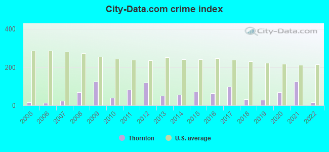
Crime rate in Thornton detailed stats: murders, rapes, robberies, assaults, burglaries, thefts, arson
Full-time law enforcement employees in 2021, including police officers: 6 (5 officers - 4 male; 1 female).
| Officers per 1,000 residents here: | 1.95 |
| New Hampshire average: | 2.14 |
 Recent articles from our blog. Our writers, many of them Ph.D. graduates or candidates, create easy-to-read articles on a wide variety of topics.

 | Move to NH - Suggested Areas & Towns? (108 replies) |
| Looking for wine lovers who might want to do wine tastings (1 reply) |
| Political climate in Portsmouth area (53 replies) |
| Second property on land near White Mountains (20 replies) |
| Septic and house inspection, Grafton County (6 replies) |
| Mountain house areas? (10 replies) |
Latest news from Thornton, NH collected exclusively by city-data.com from local newspapers, TV, and radio stations
Ancestries: English (30.2%), Irish (21.7%), French (14.8%), Italian (9.9%), Scottish (8.4%), German (7.8%).
Current Local Time: EST time zone
Incorporated in 1763
Elevation: 585 feet
Land area: 50.4 square miles.
Population density: 49 people per square mile (very low).
41 residents are foreign born (1.4% Europe, 0.5% Latin America, 0.3% Asia).
| This town: | 2.2% |
| New Hampshire: | 4.4% |
| Thornton town: | 2.3% ($2,339) |
| New Hampshire: | 2.3% ($2,946) |
Nearest city with pop. 50,000+: Manchester, NH  (64.9 miles , pop. 107,006).
Nearest city with pop. 200,000+: Boston, MA (113.6 miles , pop. 589,141).
Nearest city with pop. 1,000,000+: Bronx, NY (241.1 miles , pop. 1,332,650).
Nearest cities:
), ), Latitude: 43.91 N, Longitude: 71.63 W
Area code commonly used in this area: 603

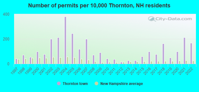
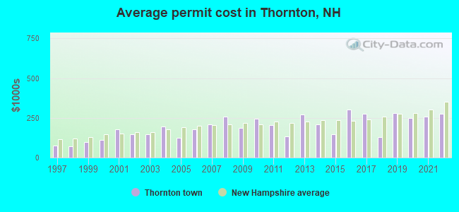
Single-family new house construction building permits:
- 2022: 31 buildings, average cost: $274,000
- 2021: 39 buildings, average cost: $259,200
- 2020: 18 buildings, average cost: $248,200
- 2019: 9 buildings, average cost: $282,200
- 2018: 30 buildings, average cost: $129,900
- 2017: 14 buildings, average cost: $275,300
- 2016: 18 buildings, average cost: $303,900
- 2015: 11 buildings, average cost: $147,300
- 2014: 5 buildings, average cost: $210,000
- 2013: 5 buildings, average cost: $269,600
- 2012: 3 buildings, average cost: $133,300
- 2011: 7 buildings, average cost: $203,300
- 2010: 8 buildings, average cost: $246,300
- 2009: 17 buildings, average cost: $187,400
- 2008: 13 buildings, average cost: $255,500
- 2007: 37 buildings, average cost: $208,400
- 2006: 22 buildings, average cost: $176,800
- 2005: 45 buildings, average cost: $123,100
- 2004: 70 buildings, average cost: $195,200
- 2003: 39 buildings, average cost: $146,600
- 2002: 37 buildings, average cost: $146,600
- 2001: 14 buildings, average cost: $179,200
- 2000: 18 buildings, average cost: $111,500
- 1999: 10 buildings, average cost: $99,700
- 1998: 13 buildings, average cost: $71,700
- 1997: 8 buildings, average cost: $75,000
| Here: | 1.9% |
| New Hampshire: | 2.5% |
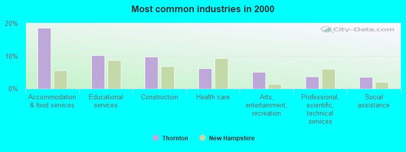
- Accommodation & food services (18.6%)
- Educational services (10.2%)
- Construction (9.7%)
- Health care (6.3%)
- Arts, entertainment, recreation (5.1%)
- Professional, scientific, technical services (3.7%)
- Social assistance (3.6%)
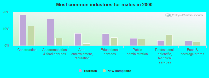
- Construction (18.2%)
- Accommodation & food services (15.8%)
- Arts, entertainment, recreation (7.4%)
- Educational services (7.2%)
- Public administration (4.4%)
- Professional, scientific, technical services (3.1%)
- Food & beverage stores (2.9%)
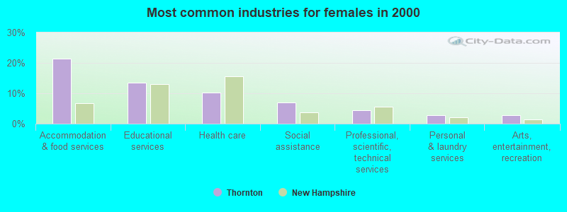
- Accommodation & food services (21.4%)
- Educational services (13.4%)
- Health care (10.1%)
- Social assistance (7.1%)
- Professional, scientific, technical services (4.4%)
- Personal & laundry services (2.7%)
- Arts, entertainment, recreation (2.7%)
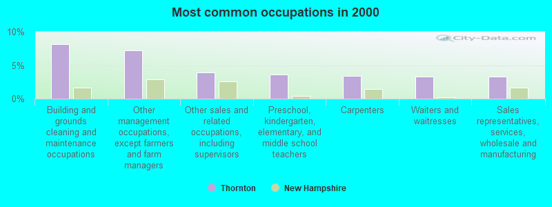
- Building and grounds cleaning and maintenance occupations (8.2%)
- Other management occupations, except farmers and farm managers (7.2%)
- Other sales and related occupations, including supervisors (3.9%)
- Preschool, kindergarten, elementary, and middle school teachers (3.6%)
- Carpenters (3.4%)
- Waiters and waitresses (3.3%)
- Sales representatives, services, wholesale and manufacturing (3.3%)
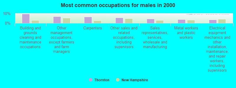
- Building and grounds cleaning and maintenance occupations (9.7%)
- Other management occupations, except farmers and farm managers (7.0%)
- Carpenters (6.6%)
- Other sales and related occupations, including supervisors (5.9%)
- Sales representatives, services, wholesale and manufacturing (4.4%)
- Metal workers and plastic workers (4.0%)
- Electrical equipment mechanics and other installation, maintenance, and repair workers, including supervisors (3.7%)
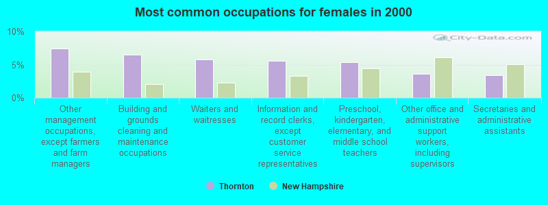
- Other management occupations, except farmers and farm managers (7.5%)
- Building and grounds cleaning and maintenance occupations (6.5%)
- Waiters and waitresses (5.7%)
- Information and record clerks, except customer service representatives (5.5%)
- Preschool, kindergarten, elementary, and middle school teachers (5.4%)
- Other office and administrative support workers, including supervisors (3.6%)
- Secretaries and administrative assistants (3.4%)
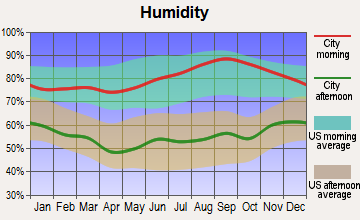
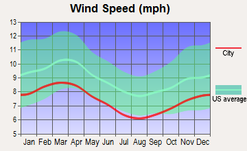
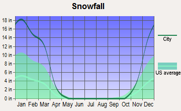
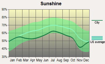
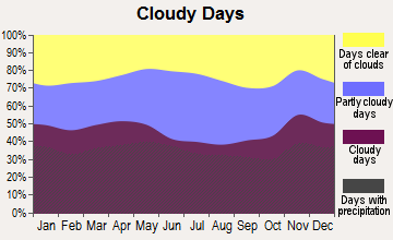
Average climate in Thornton, New Hampshire
Based on data reported by over 4,000 weather stations
(lower is better)
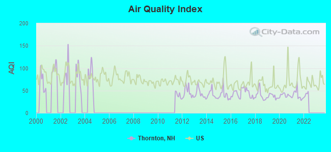
Air Quality Index (AQI) level in 2021 was 39.8. This is significantly better than average.
| City: | 39.8 |
| U.S.: | 72.6 |
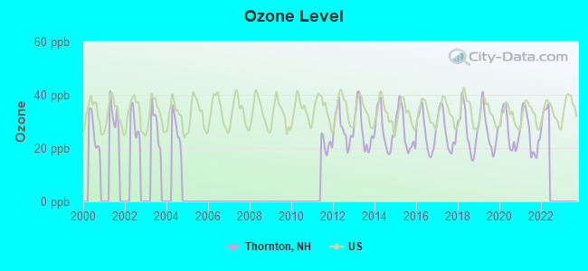
Ozone [ppb] level in 2021 was 25.7. This is better than average. Closest monitor was 3.9 miles away from the city center.
| City: | 25.7 |
| U.S.: | 33.3 |
Tornado activity:
Thornton-area historical tornado activity is below New Hampshire state average. It is 73% smaller than the overall U.S. average.
On 8/11/1966, a category F2 (max. wind speeds 113-157 mph) tornado 18.2 miles away from the Thornton town center caused between $50,000 and $500,000 in damages.
On 5/11/1973, a category F2 tornado 28.6 miles away from the town center .
Earthquake activity:
Thornton-area historical earthquake activity is significantly above New Hampshire state average. It is 72% smaller than the overall U.S. average.On 4/20/2002 at 10:50:47, a magnitude 5.3 (5.3 ML, Depth: 3.0 mi, Class: Moderate, Intensity: VI - VII) earthquake occurred 110.3 miles away from Thornton center
On 4/20/2002 at 10:50:47, a magnitude 5.2 (5.2 MB, 4.2 MS, 5.2 MW, 5.0 MW) earthquake occurred 110.7 miles away from Thornton center
On 10/7/1983 at 10:18:46, a magnitude 5.3 (5.1 MB, 5.3 LG, 5.1 ML) earthquake occurred 134.9 miles away from the city center
On 1/19/1982 at 00:14:42, a magnitude 4.7 (4.5 MB, 4.7 MD, 4.5 LG, Class: Light, Intensity: IV - V) earthquake occurred 28.7 miles away from Thornton center
On 10/16/2012 at 23:12:25, a magnitude 4.7 (4.7 ML, Depth: 10.0 mi) earthquake occurred 53.5 miles away from the city center
On 8/21/1996 at 07:54:14, a magnitude 3.8 (3.8 LG, 3.6 LG, Depth: 6.2 mi, Class: Light, Intensity: II - III) earthquake occurred 23.3 miles away from the city center
Magnitude types: regional Lg-wave magnitude (LG), body-wave magnitude (MB), duration magnitude (MD), local magnitude (ML), surface-wave magnitude (MS), moment magnitude (MW)
Natural disasters:
The number of natural disasters in Grafton County (32) is a lot greater than the US average (15).Major Disasters (Presidential) Declared: 20
Emergencies Declared: 9
Causes of natural disasters: Floods: 16, Storms: 16, Hurricanes: 3, Snows: 3, Winter Storms: 3, Tropical Storms: 2, Blizzard: 1, Heavy Rain: 1, Ice Storm: 1, Landslide: 1, Snowfall: 1, Snowstorm: 1, Wind: 1, Other: 1 (Note: some incidents may be assigned to more than one category).
Colleges/universities with over 2000 students nearest to Thornton:
- Plymouth State University (about 12 miles; Plymouth, NH; Full-time enrollment: 4,838)
- Dartmouth College (about 36 miles; Hanover, NH; FT enrollment: 6,030)
- NHTI-Concord's Community College (about 49 miles; Concord, NH; FT enrollment: 2,865)
- Norwich University (about 54 miles; Northfield, VT; FT enrollment: 4,221)
- Saint Joseph's College of Maine (about 58 miles; Standish, ME; FT enrollment: 2,010)
- Southern New Hampshire University (about 62 miles; Manchester, NH; FT enrollment: 16,552)
- University of New Hampshire-Main Campus (about 65 miles; Durham, NH; FT enrollment: 15,243)
Public elementary/middle school in Thornton:
- THORNTON CENTRAL SCHOOL (Students: 199, Location: 1886 NH RTE. 175, Grades: KG-8)
User-submitted facts and corrections:
- WPCR (91.7 FM; PLYMOUTH, NH; Owner: PLYMOUTH STATE UNIVERSITY)
Points of interest:
Notable locations in Thornton: Lyfords Siding (A), Campton Pond Forest Camp (B), Jack O'Lantern Golf Course (C), Campton Recreation Area (D), Campton - Thornton Fire Department Station 2 (E). Display/hide their locations on the map
Church in Thornton: Thorton Church (A). Display/hide its location on the map
Cemeteries: Pine Grove Cemetery (1), Mad River Cemetery (2). Display/hide their locations on the map
Lakes and swamps: Mud Pond (A), Peaked Hill Pond (B), Cone Pond (C), Brown Ash Swamp (D). Display/hide their locations on the map
Streams, rivers, and creeks: Willow Brook (A), Hubbard Brook (B), Hazelton Brook (C), Great Brook (D), Smarts Brook (E), Chickenboro Brook (F), Mack Brook (G), Burleigh Brook (H), Shattuck Brook (I). Display/hide their locations on the map
Birthplace of: Moses Cheney - Abolitionist.
Drinking water stations with addresses in Thornton and their reported violations in the past:
WILD RIVER CAMPGROUND (Address: 5 PASTURE LN , Population served: 27, Groundwater):Past monitoring violations:
- One routine major monitoring violation
Drinking water stations with addresses in Thornton that have no violations reported:
- SUGARLOAF II CPG/SITE 24 (Address: 5 PASTURE LN , Population served: 141, Primary Water Source Type: Groundwater)
- SUGARLOAF I CPG/SITES 2/4 (Address: 5 PASTURE LN , Population served: 133, Primary Water Source Type: Groundwater)
- WILDWOOD CAMPGROUND (Address: 5 PASTURE LN , Population served: 100, Primary Water Source Type: Groundwater)
- WHITE LEDGE CAMPGROUND (Address: 5 PASTURE LN , Population served: 70, Primary Water Source Type: Groundwater)
- ZEALAND CAMPGROUND (Address: 5 PASTURE LN , Population served: 28, Primary Water Source Type: Groundwater)
| This town: | 2.3 people |
| New Hampshire: | 2.5 people |
| This town: | 66.2% |
| Whole state: | 66.3% |
| This town: | 11.4% |
| Whole state: | 8.3% |
Likely homosexual households (counted as self-reported same-sex unmarried-partner households)
- Lesbian couples: 0.8% of all households
- Gay men: 0.5% of all households
| This town: | 9.5% |
| Whole state: | 6.5% |
| This town: | 3.7% |
| Whole state: | 2.8% |
For population 15 years and over in Thornton:
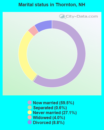
- Never married: 27.1%
- Now married: 59.5%
- Separated: 0.6%
- Widowed: 4.0%
- Divorced: 8.8%
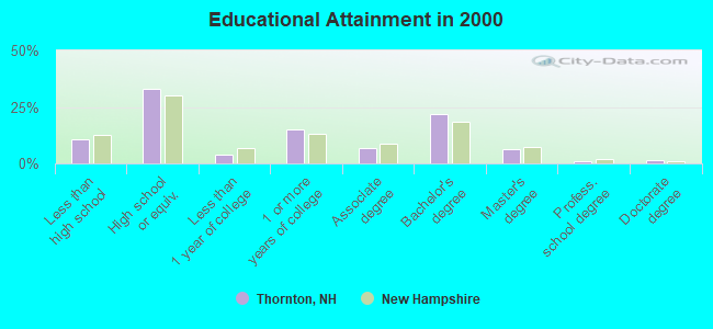
For population 25 years and over in Thornton:
- High school or higher: 89.4%
- Bachelor's degree or higher: 31.1%
- Graduate or professional degree: 9.0%
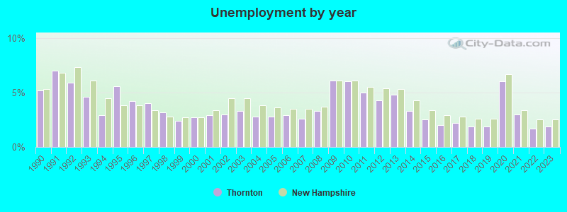
- Unemployed: 4.6%
- Mean travel time to work (commute): 24.7 minutes
| Here: | 10.3 |
| New Hampshire average: | 10.9 |


Graphs represent county-level data. Detailed 2008 Election Results
Religion statistics for Thornton, NH (based on Grafton County data)


| Religion | Adherents | Congregations |
|---|---|---|
| Catholic | 9,503 | 12 |
| Mainline Protestant | 7,832 | 57 |
| Evangelical Protestant | 1,494 | 29 |
| Other | 1,320 | 11 |
| None | 68,969 | - |
Food Environment Statistics:
| Grafton County: | 3.87 / 10,000 pop. |
| State: | 2.14 / 10,000 pop. |
| This county: | 0.23 / 10,000 pop. |
| State: | 0.15 / 10,000 pop. |
| This county: | 1.29 / 10,000 pop. |
| State: | 1.78 / 10,000 pop. |
| Grafton County: | 6.45 / 10,000 pop. |
| State: | 4.02 / 10,000 pop. |
| This county: | 14.41 / 10,000 pop. |
| State: | 9.70 / 10,000 pop. |
| This county: | 7.2% |
| State: | 7.6% |
| Here: | 22.9% |
| New Hampshire: | 24.4% |
| Grafton County: | 15.9% |
| State: | 15.9% |
Strongest AM radio stations in Thornton:
- WPNH (1300 AM; 5 kW; PLYMOUTH, NH; Owner: NORTHEAST COMMUNICATIONS CORPORATION)
- WRKO (680 AM; 50 kW; BOSTON, MA; Owner: ENTERCOM BOSTON LICENSE, LLC)
- WTWN (1100 AM; daytime; 5 kW; WELLS RIVER, VT; Owner: PUFFER BROADCASTING, INC.)
- WEZS (1350 AM; 5 kW; LACONIA, NH; Owner: GARY W. HAMMOND)
- WNTK (1020 AM; 10 kW; NEWPORT, NH; Owner: KOOR COMMUNICATIONS, INC.)
- WEEI (850 AM; 50 kW; BOSTON, MA; Owner: ENTERCOM BOSTON LICENSE, LLC)
- WCRN (830 AM; 50 kW; WORCESTER, MA; Owner: CARTER BROADCASTING CORPORATION)
- WNNZ (640 AM; 50 kW; WESTFIELD, MA; Owner: CLEAR CHANNEL BROADCASTING LICENSES, INC.)
- WASR (1420 AM; 5 kW; WOLFEBORO, NH; Owner: RADIO WOLFEBORO, INC.)
- WGIN (930 AM; 10 kW; ROCHESTER, NH; Owner: CAPSTAR TX LIMITED PARTNERSHIP)
- WCHP (760 AM; 35 kW; CHAMPLAIN, NY; Owner: CHAMPLAIN RADIO, INC.)
- WBZ (1030 AM; 50 kW; BOSTON, MA; Owner: INFINITY BROADCASTING OPERATIONS, INC.)
- WKOX (1200 AM; 50 kW; FRAMINGHAM, MA; Owner: CAPSTAR TX LIMITED PARTNERSHIP)
Strongest FM radio stations in Thornton:
- WVFM (105.7 FM; CAMPTON, NH; Owner: DEVON BROADCASTING COMPANY, INC.)
- WPKQ (103.7 FM; NORTH CONWAY, NH; Owner: CITADEL BROADCASTING COMPANY)
- WSCY (106.9 FM; MOULTONBOROUGH, NH; Owner: NORTHEAST COMMUNICATIONS CORPORATION)
- WHOM (94.9 FM; MT. WASHINGTON, NH; Owner: CITADEL BROADCASTING COMPANY)
- WPNH-FM (100.1 FM; PLYMOUTH, NH; Owner: NORTHEAST COMMUNICATIONS CORPORATION)
- WEVH (91.3 FM; HANOVER, NH; Owner: NEW HAMPSHIRE PUBLIC RADIO INC)
- WMTK (106.3 FM; LITTLETON, NH; Owner: VERMONT BROADCAST ASSOCIATES, INC.)
- WHDQ (106.1 FM; CLAREMONT, NH; Owner: GREAT NORTHERN RADIO, L.L.C.)
- WGMT (97.7 FM; LYNDON, VT; Owner: VERMONT BROADCAST ASSOCIATES, INC.)
- WLKZ (104.9 FM; WOLFEBORO, NH; Owner: TELE-MEDIA COMPANY OF NEW HAMPSHIRE, L.L.C.)
- WMEA (90.1 FM; PORTLAND, ME; Owner: MAINE PUBLIC BROADCASTING CORPORATION)
- WVPR (89.5 FM; WINDSOR, VT; Owner: VERMONT PUBLIC RADIO)
- WJJR (98.1 FM; RUTLAND, VT; Owner: 6 JOHNSON ROAD LICENSES, INC.)
- WZRT (97.1 FM; RUTLAND, VT; Owner: CAPSTAR TX LIMITED PARTNERSHIP)
- WEBK (105.3 FM; KILLINGTON, VT; Owner: 6 JOHNSON ROAD LICENSES, INC.)
- WCVT (101.7 FM; STOWE, VT; Owner: RADIO VERMONT CLASSICS, L.L.C.)
- WGLV (91.7 FM; WOODSTOCK, VT; Owner: CHRISTIAN MINISTRIES INC)
- WXXS (102.3 FM; LANCASTER, NH; Owner: BARRY P. LUNDERVILLE)
- WHDQ-FM1 (106.1 FM; RUTLAND, VT; Owner: GREAT NORTHERN RADIO, L.L.C.)
- WVPS (107.9 FM; BURLINGTON, VT; Owner: VERMONT PUBLIC RADIO)
TV broadcast stations around Thornton:
- WMTW-TV (Channel 8; POLAND SPRING, ME; Owner: WMTW BROADCAST GROUP, LLC)
- WCSH (Channel 6; PORTLAND, ME; Owner: PACIFIC AND SOUTHERN COMPANY, INC.)
- WMEA-TV (Channel 26; BIDDEFORD, ME; Owner: MAINE PUBLIC BROADCASTING CORP.)
- Thornton, New Hampshire
- Fatal accident count16
- Vehicles involved in fatal accidents19
- Fatal accidents involving drunk persons:7
- Fatalities19
- Persons involved in fatal accidents31
- Pedestrians involved in fatal accidents1
- New Hampshire average
- Fatal accident count1804
- Vehicles involved in fatal accidents2603
- Fatal accidents involving drunk persons710
- Fatalities1971
- Persons involved in fatal accidents4165
- Pedestrians involved in fatal accidents125
- National Bridge Inventory (NBI) Statistics
- 21Number of bridges
- 276ft / 83.8mTotal length
- $65,982,000Total costs
- 60,698Total average daily traffic
- 5,677Total average daily truck traffic
- 89,820Total future (year 2042) average daily traffic
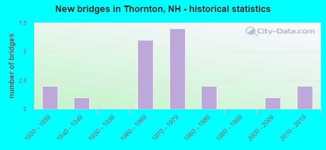
- New bridges - historical statistics
- 21930-1939
- 11940-1949
- 61960-1969
- 71970-1979
- 21980-1989
- 12000-2009
- 22010-2019
FCC Registered Broadcast Land Mobile Towers:
5- Hwy Patrol 325 Division 3 (Lat: 43.867583 Lon: -71.663694), Call Sign: KZQ641, Licensee ID: L00307774,
Assigned Frequencies: 37.9400 MHz, Grant Date: 06/29/2001, Expiration Date: 07/23/2011, Cancellation Date: 07/21/2011, Registrant: State Of New Hampshire, J O Morton Bldg Box 483, Concord, NH 03302-0483, Phone: (603) 271-2693
- Hwy Patrol 325 (Lat: 43.867583 Lon: -71.663694), Call Sign: WBC278, Licensee ID: L00307774,
Assigned Frequencies: 458.925 MHz, 458.975 MHz, Grant Date: 04/28/2015, Expiration Date: 06/04/2025, Registrant: State Of New Hampshire, Department Of Transportation, Division Of Operations, Seven Hazen Drive, Concord, NH 03302-0483, Phone: (603) 271-6862, Fax: (603) 271-8626, Email:
- Lat: 43.895750 Lon: -71.664222, Call Sign: WQNP230,
Assigned Frequencies: 72.1000 MHz, Grant Date: 04/06/2011, Expiration Date: 04/06/2021, Cancellation Date: 06/12/2021, Certifier: Jon Francis, Registrant: Primex Wireless, Inc., 965 Wells Street, Lake Geneva, WI 53147, Phone: (800) 537-0464
- Lat: 43.917667 Lon: -71.689667, Call Sign: WREP753,
Assigned Frequencies: 451.312 MHz, Grant Date: 11/21/2019, Expiration Date: 11/21/2029, Certifier: Lee Bruno, Registrant: Ossipee Mountain Electronics, Inc., 832 Whittier Hwy, Moultonborough, NH 03254, Phone: (603) 476-5581, Email:
- Lat: 43.870194 Lon: -71.654278, Call Sign: WRMX878,
Assigned Frequencies: 462.312 MHz, 467.312 MHz, 462.437 MHz, 467.437 MHz, Grant Date: 06/22/2021, Expiration Date: 06/22/2031, Certifier: John Gabbeitt, Registrant: Cara Enterprises, Inc., Las Vegas, NV 89140, Phone: (702) 838-9728, Fax: (702) 363-4607, Email:
FCC Registered Amateur Radio Licenses:
5- Call Sign: KO1P, Licensee ID: L01283321, Grant Date: 05/24/2017, Expiration Date: 07/23/2027, Registrant: Arnold O Goodman, 6 Carey Circle, Thornton, NH 03285
- Call Sign: N1YRO, Licensee ID: L01202313, Grant Date: 03/03/2017, Expiration Date: 05/02/2027, Registrant: Hope Dubois, 13 Mill Brook Rd, Thornton, NH 03285
- Call Sign: N1ZPQ, Licensee ID: L01279808, Grant Date: 04/29/2017, Expiration Date: 07/23/2027, Registrant: Shawn S Turmelle, 17 Country Ln, Thornton, NH 03285-6409
- Call Sign: KC1REW, Licensee ID: L02555082, Grant Date: 05/10/2022, Expiration Date: 05/10/2032, Cancellation Date: 06/03/2022, Certifier: David A Rardin, Registrant: David A Rardin, 2551 Nh Route 175, Thornton, NH 03285
- Call Sign: KQ1DAR, Previous Call Sign: KC1REW, Licensee ID: L02555082, Grant Date: 06/03/2022, Expiration Date: 06/03/2032, Certifier: David A Rardin, Registrant: David A Rardin, 2551 Nh Route 175, Thornton, NH 03285
FAA Registered Aircraft:
4- Aircraft: CESSNA 172G (Category: Land, Seats: 4, Weight: Up to 12,499 Pounds, Speed: 105 mph), Engine: CONT MOTOR 0-300 SER (145 HP) (Reciprocating)
N-Number: 1324F, N1324F, N-1324F, Serial Number: 17254819, Year manufactured: 1966, Airworthiness Date: 07/01/1966, Certificate Issue Date: 06/14/2011
Registrant (Individual): Ashton R J Trustee Wyllie, 503 Mill Brook Rd, Thornton, NH 03285 - Aircraft: PIPER PA-30 (Category: Land, Engines: 2, Seats: 6, Weight: Up to 12,499 Pounds, Speed: 139 mph), Engine: LYCOMING IO-320 SERIES (150 HP) (Reciprocating)
N-Number: 33SS, N33SS, N-33SS, Serial Number: 30-1104, Year manufactured: 1966, Airworthiness Date: 04/29/1966, Certificate Issue Date: 06/18/2011
Registrant (Individual): Ashton Rj Trustee Wyllie, 503 Mill Brook Rd, Thornton, NH 03285 - Aircraft: HILLER UH-12A (Category: Land, Seats: 4, Weight: Up to 12,499 Pounds, Speed: 63 mph), Engine: FRANKLIN 6A&6V335 SER (210 HP) (Reciprocating)
N-Number: 4977E, N4977E, N-4977E, Serial Number: 254, Year manufactured: 1951, Airworthiness Date: 08/01/1983, Certificate Issue Date: 09/15/2018
Registrant (Individual): Ashton R J Trustee Wyllie, 503 Mill Brook Rd, Thornton, NH 03285 - Aircraft: PIPER PA-30 (Category: Land, Engines: 2, Seats: 6, Weight: Up to 12,499 Pounds, Speed: 139 mph), Engine: LYCOMING IO-320 SERIES (150 HP) (Reciprocating)
N-Number: 8049Y, N8049Y, N-8049Y, Serial Number: 30-1161, Airworthiness Date: 06/14/1966, Certificate Issue Date: 07/29/2016
Registrant (Individual): Arj Wyllie, 503 Mill Brook Rd, Thornton, NH 03285
Deregistered: Cancel Date: 04/09/2019
2002 - 2018 National Fire Incident Reporting System (NFIRS) incidents
- Fire incident types reported to NFIRS in Thornton, NH
- 17547.2%Structure Fires
- 10127.2%Other
- 6918.6%Outside Fires
- 267.0%Mobile Property/Vehicle Fires
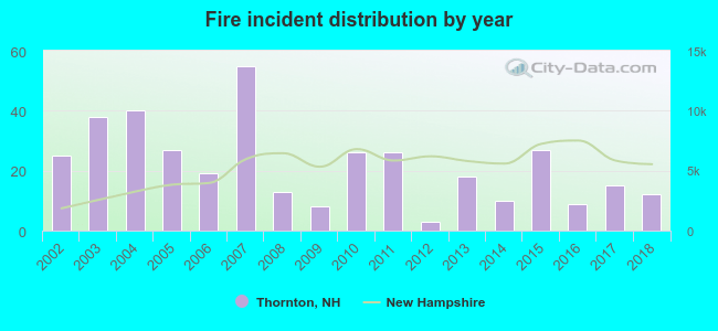 According to the data from the years 2002 - 2018 the average number of fires per year is 22. The highest number of fire incidents - 55 took place in 2007, and the least - 3 in 2012. The data has a declining trend.
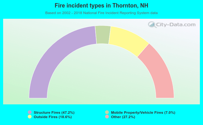 When looking into fire subcategories, the most reports belonged to: Structure Fires (47.2%), and Other (27.2%).
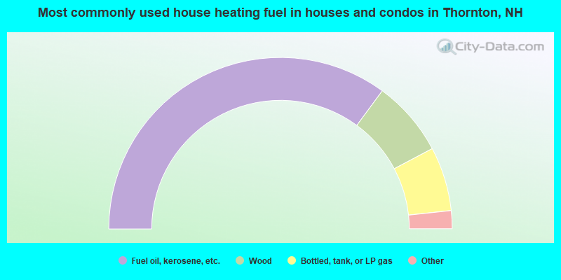
- 70.2%Fuel oil, kerosene, etc.
- 14.3%Wood
- 12.1%Bottled, tank, or LP gas
- 3.1%Electricity
- 0.4%Coal or coke
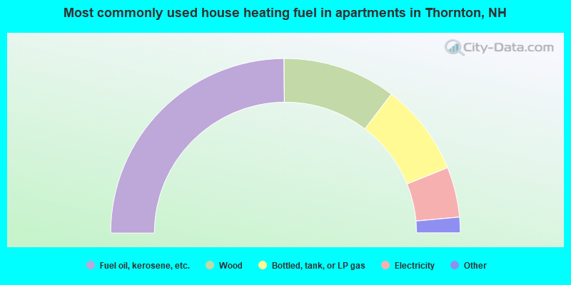
- 49.8%Fuel oil, kerosene, etc.
- 21.0%Wood
- 17.1%Bottled, tank, or LP gas
- 9.3%Electricity
- 1.5%Utility gas
- 1.5%No fuel used
Thornton compared to New Hampshire state average:
- Unemployed percentage below state average.
- Black race population percentage significantly below state average.
- Hispanic race population percentage significantly below state average.
- Foreign-born population percentage significantly below state average.
- Length of stay since moving in significantly above state average.
- Number of rooms per house significantly below state average.
- House age significantly below state average.

|
Total of 8 patent applications in 2008-2024.