Bridge Statistics for Sandy Springs, Georgia (GA)
Condition, Traffic, Stress, Structural Evaluation, Project Costs
- National Bridge Inventory (NBI) Statistics
- 120Number of bridges
- 1,657ft / 505mTotal length
- $363,228,000Total costs
- 8,386,597Total average daily traffic
- 115,312Total average daily truck traffic
- National Bridge Inventory (NBI) Registered Bridges for Sandy Springs
- No street view available for this location
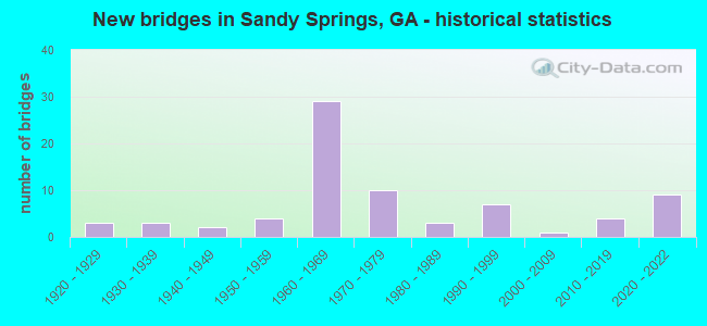
- New bridges - historical statistics
- 31920-1929
- 31930-1939
- 21940-1949
- 41950-1959
- 291960-1969
- 101970-1979
- 31980-1989
- 71990-1999
- 12000-2009
- 42010-2019
- 92020-2022

- Reconstructed bridges - Historical Statistics
- 11950-1959
- 11960-1969
- 31970-1979
- 61980-1989
- 61990-1999
- 02000-2009
- 22010-2019


- Bridge Condition - Deck
- 13.6%Very good
- 56.1%Good
- 25.8%Satisfactory
- 4.5%Fair

- Bridge Condition - Superstructure
- 31.8%Very good
- 56.1%Good
- 9.1%Satisfactory
- 3.0%Fair

- Bridge Condition - Substructure
- 9.1%Very good
- 69.7%Good
- 16.7%Satisfactory
- 4.5%Fair

- Bridge Condition - Channel
- 16.2%Very good
- 54.1%Good
- 18.9%Satisfactory
- 10.8%Fair
Find on map >> Show street view
Structure Number: 1210246, Location: IN N FULTON (Lat: 33.910214, Lng: -84.361739), Route carried "under" structure: City street 9252, Structure Length: 0. m, Average Daily Traffic: 27,500 (year 1998), Truck Traffic: 1%, Features Intersected: I-285 (SR 407), Facility Carried by Structure: I-285
Minimum Vertical Clearance: 5.30m (17.39ft), Kilometerpoint: 1.609, Lanes on structure: 12, Length of Maximum Span: 0.0m
Find on map >> Show street view
Structure Number: 1210247, Location: IN N FULTON (Lat: 33.911831, Lng: -84.356681), Route carried "under" structure: US 19, Structure Length: 0. m, Average Daily Traffic: 186,700 (year 1998), Truck Traffic: 1%, Features Intersected: I-285 (SR 407), Facility Carried by Structure: I-285
Minimum Vertical Clearance: 5.91m (19.39ft), Kilometerpoint: 11.265, Lanes on structure: 12, Length of Maximum Span: 0.0m
Find on map >> Show street view
Structure Number: 1210248, Location: IN N FULTON (Lat: 33.913842, Lng: -84.351947), Route carried "under" structure: City street 7000, Structure Length: 0. m, Average Daily Traffic: 34,120 (year 1998), Truck Traffic: 1%, Features Intersected: I-285 (SR 407), Facility Carried by Structure: I-285
Minimum Vertical Clearance: 5.35m (17.55ft), Kilometerpoint: 8.047, Lanes on structure: 13, Length of Maximum Span: 0.0m
Find on map >> Show street view
Structure Number: 1210257, Location: IN N FULTON (Lat: 33.913289, Lng: -84.357089), Route carried "under" structure: US 19, Structure Length: 0. m, Average Daily Traffic: 182,300 (year 1998), Truck Traffic: 1%, Features Intersected: I-285 RMP CCB TO SR 400, Facility Carried by Structure: I-285R CCB TO SR40
Minimum Vertical Clearance: 9.85m (32.32ft), Kilometerpoint: 11.265, Lanes on structure: 1, Length of Maximum Span: 0.0m
Find on map >> Show street view
Structure Number: 1210316, Location: 2.1 MI SW OF ROSWELL (Lat: 33.991689, Lng: -84.338189), Route carried "under" structure: US 19, Structure Length: 0. m, Average Daily Traffic: 167,400 (year 1999), Truck Traffic: 1%, Features Intersected: CR 139 ROBERTS DRIVE, Facility Carried by Structure: ROBERTS DRIVE
Minimum Vertical Clearance: 5.63m (18.47ft), Kilometerpoint: 20.921, Lanes on structure: 2, Length of Maximum Span: 0.0m
Find on map >> Show street view
Structure Number: 1210327, Location: IN N ATLANTA (Lat: 33.906458, Lng: -84.431989), Route carried "under" structure: Interstate 285, Structure Length: 0. m, Average Daily Traffic: 249,300 (year 2011), Truck Traffic: 1%, Features Intersected: M-9022 NORTHSIDE DR. SBL, Facility Carried by Structure: NORTHSIDE DR (SBL)
Minimum Vertical Clearance: 7.62m (25.00ft), Kilometerpoint: 35.406, Lanes on structure: 3, Length of Maximum Span: 0.0m
Find on map >> Show street view
Structure Number: 1210444, Location: IN N FULTON (Lat: 33.914919, Lng: -84.400619), Route carried "under" structure: Interstate 285, Structure Length: 0. m, Average Daily Traffic: 244,400 (year 2011), Truck Traffic: 1%, Features Intersected: M-9212 MT. VERNON HWY., Facility Carried by Structure: MT. VERNON HWY
Minimum Vertical Clearance: 5.41m (17.75ft), Kilometerpoint: 38.624, Lanes on structure: 2, Length of Maximum Span: 0.0m
Find on map >> Show street view
Structure Number: 1210452, Location: IN N FULTON (Lat: 33.915900, Lng: -84.406658), Route carried "under" structure: Interstate 285, Structure Length: 0. m, Average Daily Traffic: 244,400 (year 2011), Truck Traffic: 1%, Features Intersected: M-9248 RIVERSIDE DRIVE, Facility Carried by Structure: RIVERSIDE DRIVE
Minimum Vertical Clearance: 7.46m (24.48ft), Kilometerpoint: 37.015, Lanes on structure: 2, Length of Maximum Span: 0.0m
Find on map >> Show street view
Structure Number: 1210455, Location: 3.2 MI N OF I-285 (Lat: 33.956811, Lng: -84.356228), Route carried "under" structure: US 19, Structure Length: 0. m, Average Daily Traffic: 173,900 (year 1999), Truck Traffic: 1%, Features Intersected: M-9248 SPALDING DRIVE, Facility Carried by Structure: SPALDING DRIVE
Minimum Vertical Clearance: 5.68m (18.64ft), Kilometerpoint: 16.093, Lanes on structure: 4, Length of Maximum Span: 0.0m
Find on map >> Show street view
Structure Number: 1210476, Location: 4.3 MI N OF I-285 (Lat: 33.970169, Lng: -84.347889), Route carried "under" structure: US 9387, Structure Length: 0. m, Average Daily Traffic: 173,900 (year 1999), Truck Traffic: 1%, Features Intersected: M-9387 PITTS ROAD, Facility Carried by Structure: PITTS ROAD
Minimum Vertical Clearance: 5.18m (16.99ft), Kilometerpoint: 17.703, Lanes on structure: 2, Length of Maximum Span: 0.0m
Find on map >> Show street view
Structure Number: 1210477, Location: IN N ATLANTA (Lat: 33.915969, Lng: -84.414197), Route carried "under" structure: Interstate 285, Structure Length: 0. m, Average Daily Traffic: 249,300 (year 2010), Truck Traffic: 1%, Features Intersected: CR 288 HEARDS ROAD, Facility Carried by Structure: RAIDER ROAD
Minimum Vertical Clearance: 5.74m (18.83ft), Kilometerpoint: 37.015, Lanes on structure: 2, Length of Maximum Span: 0.0m
Find on map >> Show street view
Structure Number: 1210625, Location: IN N FULTON (Lat: 33.908378, Lng: -84.429778), Route carried "under" structure: Interstate 285, Structure Length: 0. m, Average Daily Traffic: 249,300 (year 2010), Truck Traffic: 1%, Features Intersected: M-9016 NEW N'SIDE DR NBL, Facility Carried by Structure: NEW N'SIDE DR NBL
Minimum Vertical Clearance: 7.34m (24.08ft), Kilometerpoint: 35.406, Lanes on structure: 3, Length of Maximum Span: 0.0m
Find on map >> Show street view
Structure Number: 1210749, Location: IN N FULTON (Lat: 33.903078, Lng: -84.359436), Route carried "under" structure: Ramp State highway 400, Structure Length: 0. m, Average Daily Traffic: 11,150 (year 2002), Truck Traffic: 1%, Features Intersected: M-9252 GLENRIDGE PKWY, Facility Carried by Structure: GLENRIDGE PWY
Minimum Vertical Clearance: 5.71m (18.73ft), Kilometerpoint: 9.656, Lanes on structure: 7, Length of Maximum Span: 0.0m
Find on map >> Show street view
Structure Number: 1210749, Location: IN N FULTON (Lat: 33.903078, Lng: -84.359436), Route carried "under" structure: State highway 400, Structure Length: 0. m, Average Daily Traffic: 64,000 (year 1995), Truck Traffic: 1%, Features Intersected: M-9252 GLENRIDGE PKWY, Facility Carried by Structure: GLENRIDGE PWY
Minimum Vertical Clearance: 6.22m (20.41ft), Kilometerpoint: 9.656, Lanes on structure: 7, Length of Maximum Span: 0.0m
Find on map >> Show street view
Structure Number: 1210749, Location: IN N FULTON (Lat: 33.903078, Lng: -84.359436), Route carried "under" structure: Ramp State highway 400, Structure Length: 0. m, Average Daily Traffic: 11,150 (year 2002), Truck Traffic: 1%, Features Intersected: M-9252 GLENRIDGE PKWY, Facility Carried by Structure: GLENRIDGE PWY
Minimum Vertical Clearance: 6.62m (21.72ft), Kilometerpoint: 9.656, Lanes on structure: 7, Length of Maximum Span: 0.0m
Find on map >> Show street view
Structure Number: 1210752, Location: IN N FULTON (Lat: 33.884700, Lng: -84.364908), Route carried "under" structure: State highway 400, Structure Length: 0. m, Average Daily Traffic: 112,600 (year 1998), Truck Traffic: 1%, Features Intersected: M-9254 WINDSOR PARKWAY, Facility Carried by Structure: WINDSOR PARKWAY
Minimum Vertical Clearance: 5.96m (19.55ft), Kilometerpoint: 8.047, Lanes on structure: 2, Length of Maximum Span: 0.0m
Find on map >> Show street view
Structure Number: 1210753, Location: IN N FULTON (Lat: 33.894950, Lng: -84.364078), Route carried "under" structure: State highway 400, Structure Length: 0. m, Average Daily Traffic: 112,600 (year 1998), Truck Traffic: 1%, Features Intersected: M-9256 NORTHLAND DRIVE, Facility Carried by Structure: NORTHLAND DRIVE
Minimum Vertical Clearance: 6.35m (20.83ft), Kilometerpoint: 9.656, Lanes on structure: 2, Length of Maximum Span: 0.0m
Find on map >> Show street view
Structure Number: 1210754, Location: IN N FULTON (Lat: 33.907339, Lng: -84.357489), Route carried "under" structure: Ramp State highway 400, Structure Length: 0. m, Average Daily Traffic: 8,650 (year 2002), Truck Traffic: 1%, Features Intersected: M-9258 JOHNSON FERRY RD, Facility Carried by Structure: JOHNSON FERRY RD
Minimum Vertical Clearance: 9.14m (29.99ft), Kilometerpoint: 11.265, Lanes on structure: 6, Length of Maximum Span: 0.0m
Find on map >> Show street view
Structure Number: 1210754, Location: IN N FULTON (Lat: 33.907339, Lng: -84.357489), Route carried "under" structure: Ramp State highway 400, Structure Length: 0. m, Average Daily Traffic: 8,650 (year 2002), Truck Traffic: 1%, Features Intersected: M-9258 JOHNSON FERRY RD, Facility Carried by Structure: JOHNSON FERRY RD
Minimum Vertical Clearance: 6.37m (20.90ft), Kilometerpoint: 11.265, Lanes on structure: 6, Length of Maximum Span: 0.0m
Find on map >> Show street view
Structure Number: 1210754, Location: IN N FULTON (Lat: 33.907339, Lng: -84.357489), Route carried "under" structure: State highway 400, Structure Length: 0. m, Average Daily Traffic: 104,800 (year 1998), Truck Traffic: 1%, Features Intersected: M-9258 JOHNSON FERRY RD, Facility Carried by Structure: JOHNSON FERRY RD
Minimum Vertical Clearance: 9.37m (30.74ft), Kilometerpoint: 11.265, Lanes on structure: 6, Length of Maximum Span: 0.0m
Find on map >> Show street view
Structure Number: 1215309, Location: 5.15 MI S OF ROSWELL (Lat: 33.944044, Lng: -84.357875), Route carried "under" structure: US 19, Structure Length: 0. m, Average Daily Traffic: 134,600 (year 2002), Truck Traffic: 8%, Features Intersected: SR 400 RMP TO MARTA STAT, Facility Carried by Structure: 400 RAMP TO MARTA
Minimum Vertical Clearance: 8.30m (27.23ft), Kilometerpoint: 14.484, Lanes on structure: 2, Length of Maximum Span: 0.0m
Find on map >> Show street view
Structure Number: 1215348, Location: 0.7 MILES NORTH OF I-285 (Lat: 33.918986, Lng: -84.357847), Route carried "under" structure: US 9255, Structure Length: 0. m, Average Daily Traffic: 189,100 (year 2008), Truck Traffic: 4%, Features Intersected: M-9255 HAMMOND DRIVE, Facility Carried by Structure: HAMMOND DRIVE
Minimum Vertical Clearance: 6.88m (22.57ft), Kilometerpoint: 11.265, Lanes on structure: 9, Length of Maximum Span: 0.0m
Find on map >> Show street view
Structure Number: 1215363, Location: 5.2 MI N OF I-285 (Lat: 33.982197, Lng: -84.341031), Route carried "under" structure: US 9260, Structure Length: 0. m, Average Daily Traffic: 31,025 (year 2014), Truck Traffic: 6%, Features Intersected: M-9260 NORTHRIDGE ROAD, Facility Carried by Structure: NORTH RIDGE ROAD
Minimum Vertical Clearance: 6.17m (20.24ft), Kilometerpoint: 19.312, Lanes on structure: 5, Length of Maximum Span: 0.0m
Find on map >> Show street view
Structure Number: 121539, Location: 1.4 MI N OF I-285 (Lat: 33.929828, Lng: -84.357828), Route carried "under" structure: US 19, Structure Length: 0. m, Average Daily Traffic: 189,100 (year 1999), Truck Traffic: 1%, Features Intersected: MT. VERNON HWY, Facility Carried by Structure: MT. VERNON HWY
Minimum Vertical Clearance: 5.28m (17.32ft), Kilometerpoint: 12.875, Lanes on structure: 4, Length of Maximum Span: 0.0m
Find on map >> Show street view
Structure Number: 1215402, Location: IN S. SANDY SPRINGS (Lat: 33.910897, Lng: -84.361800), Route carried "under" structure: City street 351, Structure Length: 0. m, Average Daily Traffic: 27,500 (year 1998), Truck Traffic: 1%, Features Intersected: INTERSTATE 285, Facility Carried by Structure: INTERSTATE 285
Minimum Vertical Clearance: 7.08m (23.23ft), Kilometerpoint: 2.124, Lanes on structure: 1, Length of Maximum Span: 0.0m
Find on map >> Show street view
Structure Number: 1215403, Location: IN S. SANDY SPRINGS (Lat: 33.910800, Lng: -84.361900), Route carried "under" structure: City street 351, Structure Length: 0. m, Average Daily Traffic: 27,500 (year 1998), Truck Traffic: 1%, Features Intersected: INTERSTATE 285, Facility Carried by Structure: INTERSTATE 285
Minimum Vertical Clearance: 6.09m (19.98ft), Kilometerpoint: 2.092, Lanes on structure: 2, Length of Maximum Span: 0.0m
Find on map >> Show street view
Structure Number: 1215404, Location: IN S. SANDY SPRINGS (Lat: 33.912300, Lng: -84.354100), Route carried "under" structure: Ramp State highway 400, Structure Length: 0. m, Average Daily Traffic: 8,650 (year 2002), Truck Traffic: 1%, Features Intersected: INTERSTATE 285, Facility Carried by Structure: INTERSTATE 285
Minimum Vertical Clearance: 5.94m (19.49ft), Kilometerpoint: 11.201, Lanes on structure: 1, Length of Maximum Span: 0.0m
Find on map >> Show street view
Structure Number: 1215404, Location: IN S. SANDY SPRINGS (Lat: 33.912300, Lng: -84.354100), Route carried "under" structure: City street 7000, Structure Length: 0. m, Average Daily Traffic: 34,120 (year 1998), Truck Traffic: 1%, Features Intersected: INTERSTATE 285, Facility Carried by Structure: INTERSTATE 285
Minimum Vertical Clearance: 6.50m (21.33ft), Kilometerpoint: 7.387, Lanes on structure: 1, Length of Maximum Span: 0.0m
Find on map >> Show street view
Structure Number: 1215405, Location: IN S. SANDY SPRINGS (Lat: 33.912817, Lng: -84.352669), Route carried "under" structure: City street 7000, Structure Length: 0. m, Average Daily Traffic: 34,120 (year 1998), Truck Traffic: 1%, Features Intersected: INTERSTATE 285 RAMP, Facility Carried by Structure: 400NB TO 285EB
Minimum Vertical Clearance: 7.11m (23.33ft), Kilometerpoint: 7.403, Lanes on structure: 1, Length of Maximum Span: 0.0m
Find on map >> Show street view
Structure Number: 1215406, Location: IN S. SANDY SPRINGS (Lat: 33.911297, Lng: -84.356681), Route carried "under" structure: US 19, Structure Length: 0. m, Average Daily Traffic: 186,700 (year 1998), Truck Traffic: 1%, Features Intersected: INTERSTATE 285, Facility Carried by Structure: INTERSTATE 285
Minimum Vertical Clearance: 5.63m (18.47ft), Kilometerpoint: 11.104, Lanes on structure: 2, Length of Maximum Span: 0.0m
Find on map >> Show street view
Structure Number: 1215406, Location: IN S. SANDY SPRINGS (Lat: 33.911297, Lng: -84.356681), Route carried "under" structure: Ramp US 19, Structure Length: 0. m, Average Daily Traffic: 186,700 (year 1998), Truck Traffic: 1%, Features Intersected: INTERSTATE 285, Facility Carried by Structure: INTERSTATE 285
Minimum Vertical Clearance: 5.18m (16.99ft), Kilometerpoint: 11.088, Lanes on structure: 2, Length of Maximum Span: 0.0m
Find on map >> Show street view
Structure Number: 1215406, Location: IN S. SANDY SPRINGS (Lat: 33.911297, Lng: -84.356681), Route carried "under" structure: US 19, Structure Length: 0. m, Average Daily Traffic: 186,700 (year 1998), Truck Traffic: 1%, Features Intersected: INTERSTATE 285, Facility Carried by Structure: INTERSTATE 285
Minimum Vertical Clearance: 5.28m (17.32ft), Kilometerpoint: 11.121, Lanes on structure: 2, Length of Maximum Span: 0.0m
Find on map >> Show street view
Structure Number: 1215407, Location: IN S. SANDY SPRINGS (Lat: 33.911200, Lng: -84.359681), Route carried "under" structure: Ramp US 19, Structure Length: 0. m, Average Daily Traffic: 38,899 (year 2013), Truck Traffic: 1%, Features Intersected: INTERSTATE 285, Facility Carried by Structure: INTERSTATE 285
Minimum Vertical Clearance: 5.41m (17.75ft), Kilometerpoint: 42.487, Lanes on structure: 1, Length of Maximum Span: 0.0m
Find on map >> Show street view
Structure Number: 1215408, Location: IN S. SANDY SPRINGS (Lat: 33.912214, Lng: -84.356781), Route carried "under" structure: US 19, Structure Length: 0. m, Average Daily Traffic: 186,700 (year 1998), Truck Traffic: 1%, Features Intersected: INTERSTATE 285, Facility Carried by Structure: INTERSTATE 285
Minimum Vertical Clearance: 5.81m (19.06ft), Kilometerpoint: 11.217, Lanes on structure: 2, Length of Maximum Span: 0.0m
Find on map >> Show street view
Structure Number: 1215408, Location: IN S. SANDY SPRINGS (Lat: 33.912214, Lng: -84.356781), Route carried "under" structure: US 19, Structure Length: 0. m, Average Daily Traffic: 186,700 (year 1998), Truck Traffic: 1%, Features Intersected: INTERSTATE 285, Facility Carried by Structure: INTERSTATE 285
Minimum Vertical Clearance: 5.63m (18.47ft), Kilometerpoint: 11.201, Lanes on structure: 2, Length of Maximum Span: 0.0m
Find on map >> Show street view
Structure Number: 1215408, Location: IN S. SANDY SPRINGS (Lat: 33.912214, Lng: -84.356781), Route carried "under" structure: Ramp US 19, Structure Length: 0. m, Average Daily Traffic: 186,700 (year 1998), Truck Traffic: 1%, Features Intersected: INTERSTATE 285, Facility Carried by Structure: INTERSTATE 285
Minimum Vertical Clearance: 5.48m (17.98ft), Kilometerpoint: 11.185, Lanes on structure: 2, Length of Maximum Span: 0.0m
Find on map >> Show street view
Structure Number: 121541, Location: IN S. SANDY SPRINGS (Lat: 33.909817, Lng: -84.361697), Route carried "under" structure: City street 351, Structure Length: 0. m, Average Daily Traffic: 27,500 (year 1998), Truck Traffic: 1%, Features Intersected: INTERSTATE 285, Facility Carried by Structure: INTERSTATE 285
Minimum Vertical Clearance: 5.20m (17.06ft), Kilometerpoint: 1.609, Lanes on structure: 2, Length of Maximum Span: 0.0m