Bridge Statistics for Sandy Springs, Georgia (GA)
Condition, Traffic, Stress, Structural Evaluation, Project Costs
- National Bridge Inventory (NBI) Statistics
- 120Number of bridges
- 1,657ft / 505mTotal length
- $363,228,000Total costs
- 8,386,597Total average daily traffic
- 115,312Total average daily truck traffic
- National Bridge Inventory (NBI) Registered Bridges for Sandy Springs
- No street view available for this location
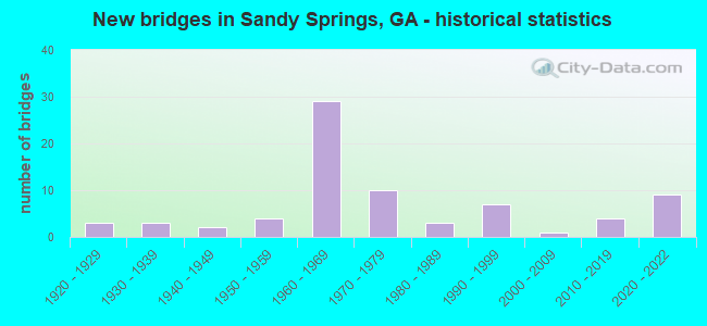
- New bridges - historical statistics
- 31920-1929
- 31930-1939
- 21940-1949
- 41950-1959
- 291960-1969
- 101970-1979
- 31980-1989
- 71990-1999
- 12000-2009
- 42010-2019
- 92020-2022

- Reconstructed bridges - Historical Statistics
- 11950-1959
- 11960-1969
- 31970-1979
- 61980-1989
- 61990-1999
- 02000-2009
- 22010-2019


- Bridge Condition - Deck
- 13.6%Very good
- 56.1%Good
- 25.8%Satisfactory
- 4.5%Fair

- Bridge Condition - Superstructure
- 31.8%Very good
- 56.1%Good
- 9.1%Satisfactory
- 3.0%Fair

- Bridge Condition - Substructure
- 9.1%Very good
- 69.7%Good
- 16.7%Satisfactory
- 4.5%Fair

- Bridge Condition - Channel
- 16.2%Very good
- 54.1%Good
- 18.9%Satisfactory
- 10.8%Fair
Find on map >> Show street view
Structure Number: 1210456, Location: .6 MI N OF MT PARAN ROAD (Lat: 33.901839, Lng: -84.396758), Route carried "on" structure: County highway 9249, Year Built: 1927, Status: Open, Structure Length: 0.98m (3.22ft), Average Daily Traffic: 3,740 (year 2011), Truck Traffic: 1%, Average Future Daily Traffic: 5,610 (year 2031), Features Intersected: LONG ISLAND CREEK, Facility Carried by Structure: LONG ISLAND DRIVE
Minimum Vertical Clearance: 30+ m (98+ ft), Kilometerpoint: 0.000, Lanes on structure: 2, Base Highway Network: Yes, Owner: City or Municipal Highway Agency, Approaching Roadway Width: 7.9m (25.9ft), Material/Design: Steel, Design/Construction: Stringer/Multi-beam, Number Of Spans In Main Unit: 1, Length of Maximum Span: 9.8m (32.2ft), Curb or Sidewalk Widths: Left: 0.2m (0.7ft), Right: 0.2m (0.7ft), Curb-To-Curb Width: 6.9m (22.6ft), Out-to-Out Width: 7.6m (24.9ft)
Condition: Deck: Satisfactory, Superstructure: Good, Substructure: Fair, Channel: Satisfactory, Inventory Rating: 80.7 metric tons, Method Used To Determine Inventory Rating: Load Factor (LF), Structural Evaluation: Somewhat better than minimum adequacy, Deck Geometry: High priority of replacement, Waterway Adequacy: Equal to present desirable criteria, Approach Roadway Alignment: Better than present minimum criteria, Length Of Structure Improvement: 41.48m (136.09ft), Designated Inspection Frequency: Every 24 months, Inspection Date: April 2020, Bridge Improvement Cost: $125,000, Roadway Improvement Cost: $13,000, Total Project Cost: $188,000, Deck Structure Type: Concrete Cast-file-Place, Wearing Surface/Protective System: Wearing Surface: Bituminous
Find on map >> Show street view
Structure Number: 1210457, Location: 2 MI W OF JCT US 19 (Lat: 33.943658, Lng: -84.405058), Route carried "on" structure: County highway 655, Year Built: 1969, Year Reconstructed: 1981, Status: Open, Structure Length: 11.95m (39.21ft), Average Daily Traffic: 39,920 (year 2012), Truck Traffic: 1%, Average Future Daily Traffic: 59,880 (year 2032), Design Load: HS 20+Mod, Features Intersected: CHATTAHOOCHEE RIVER, Facility Carried by Structure: JOHNSON FERRY RD
Minimum Vertical Clearance: 30+ m (98+ ft), Kilometerpoint: 3.219, Lanes on structure: 4, Base Highway Network: Yes, Owner: City or Municipal Highway Agency, Approaching Roadway Width: 15.8m (51.8ft), Material/Design: Prestressed concrete, Design/Construction: Stringer/Multi-beam, Number Of Spans In Main Unit: 7, Length of Maximum Span: 17.1m (56.1ft), Curb or Sidewalk Widths: Left: 1.8m (5.9ft), Right: 1.8m (5.9ft), Curb-To-Curb Width: 15.8m (51.8ft), Out-to-Out Width: 20.0m (65.6ft)
Condition: Deck: Good, Superstructure: Good, Substructure: Satisfactory, Channel: Fair, Operating Rating: 47.1 metric tons, Method Used To Determine Operating Rating: Load Factor (LF), Inventory Rating: 28.1 metric tons, Method Used To Determine Inventory Rating: Load Factor (LF), Structural Evaluation: Equal to present minimum criteria, Deck Geometry: Meets minimum limits, Waterway Adequacy: Equal to present minimum criteria, Approach Roadway Alignment: Equal to present desirable criteria, Designated Inspection Frequency: Every 24 months, Underwater Inspection Frequency: Every 60 months, Inspection Date: April 2020, Underwater Inspection Date: September 2018, Bridge Improvement Cost: $2,367,000, Roadway Improvement Cost: $237,000, Total Project Cost: $3,551,000, Deck Structure Type: Concrete Cast-file-Place
Find on map >> Show street view
Structure Number: 1210458, Location: 2.2 MI E OF JCT SR 9 (Lat: 33.886000, Lng: -84.359469), Route carried "on" structure: County highway 9254, Year Built: 1929, Status: Open, Structure Length: 1.83m (6.00ft), Average Daily Traffic: 9,220 (year 2011), Truck Traffic: 1%, Average Future Daily Traffic: 13,830 (year 2031), Features Intersected: NANCY CREEK, Facility Carried by Structure: WINDSOR PARKWAY
Minimum Vertical Clearance: 30+ m (98+ ft), Kilometerpoint: 3.219, Lanes on structure: 2, Base Highway Network: Yes, Owner: City or Municipal Highway Agency, Approaching Roadway Width: 7.3m (24.0ft), Material/Design: Steel, Design/Construction: Stringer/Multi-beam, Number Of Spans In Main Unit: 2, Length of Maximum Span: 9.1m (29.9ft), Curb-To-Curb Width: 7.0m (23.0ft), Out-to-Out Width: 7.9m (25.9ft)
Condition: Deck: Good, Superstructure: Good, Substructure: Satisfactory, Channel: Satisfactory, Operating Rating: 34.4 metric tons, Method Used To Determine Operating Rating: Allowable Stress (AS), Inventory Rating: 20.8 metric tons, Method Used To Determine Inventory Rating: Allowable Stress (AS), Structural Evaluation: Somewhat better than minimum adequacy, Deck Geometry: High priority of replacement, Waterway Adequacy: Equal to present minimum criteria, Approach Roadway Alignment: Equal to present minimum criteria, Length Of Structure Improvement: 42.06m (137.99ft), Designated Inspection Frequency: Every 24 months, Underwater Inspection Frequency: Every 60 months, Inspection Date: April 2020, Underwater Inspection Date: August 2018, Bridge Improvement Cost: $234,000, Roadway Improvement Cost: $23,000, Total Project Cost: $352,000, Deck Structure Type: Concrete Cast-file-Place, Wearing Surface/Protective System: Wearing Surface: Bituminous
Find on map >> Show street view
Structure Number: 1210472, Location: FULTON-GWINNETT CO LINE (Lat: 33.973558, Lng: -84.262758), Route carried "on" structure: State highway 140, Year Built: 1960, Year Reconstructed: 1982, Status: Open, Structure Length: 9.08m (29.79ft), Average Daily Traffic: 46,630 (year 2012), Truck Traffic: 1%, Average Future Daily Traffic: 69,945 (year 2032), Design Load: H 15, Features Intersected: CHATTAHOOCHEE RIVER, Facility Carried by Structure: HOLCOMB BR ROAD
Minimum Vertical Clearance: 30+ m (98+ ft), Kilometerpoint: 22.531, Lanes on structure: 4, Base Highway Network: Yes, Owner: State Highway Agency, Approaching Roadway Width: 15.8m (51.8ft), Material/Design: Steel continuous, Design/Construction: Stringer/Multi-beam, Number Of Spans In Main Unit: 4, Length of Maximum Span: 31.7m (104.0ft), Curb or Sidewalk Widths: Left: 1.8m (5.9ft), Right: 1.8m (5.9ft), Curb-To-Curb Width: 15.8m (51.8ft), Out-to-Out Width: 20.2m (66.3ft)
Condition: Deck: Good, Superstructure: Good, Substructure: Good, Channel: Very good, Operating Rating: 33.5 metric tons, Method Used To Determine Operating Rating: Load Factor (LF), Inventory Rating: 19.9 metric tons, Method Used To Determine Inventory Rating: Load Factor (LF), Structural Evaluation: Somewhat better than minimum adequacy, Deck Geometry: Meets minimum limits, Waterway Adequacy: Equal to present desirable criteria, Approach Roadway Alignment: Equal to present desirable criteria, Designated Inspection Frequency: Every 24 months, Underwater Inspection Frequency: Every 60 months, Inspection Date: August 2021, Underwater Inspection Date: August 2018, Bridge Improvement Cost: $1,799,000, Roadway Improvement Cost: $180,000, Total Project Cost: $2,699,000, Deck Structure Type: Concrete Cast-file-Place, Wearing Surface/Protective System: Wearing Surface: Bituminous
Find on map >> Show street view
Structure Number: 1210476, Location: 4.3 MI N OF I-285 (Lat: 33.970169, Lng: -84.347889), Route carried "on" structure: City street 9387, Year Built: 1968, Status: Open, Structure Length: 7.19m (23.59ft), Average Daily Traffic: 13,694 (year 2011), Truck Traffic: 1%, Average Future Daily Traffic: 20,541 (year 2031), Design Load: HS 20+Mod, Features Intersected: SR 400 (US 19), Facility Carried by Structure: PITTS ROAD
Minimum Vertical Clearance: 30+ m (98+ ft), Kilometerpoint: 0.000, Lanes on structure: 2, Lanes under structure: 8, Base Highway Network: Yes, Owner: State Highway Agency, Approaching Roadway Width: 9.1m (29.9ft), Skew: 1 degrees, Material/Design: Steel continuous, Design/Construction: Stringer/Multi-beam, Number Of Spans In Main Unit: 4, Length of Maximum Span: 21.3m (69.9ft), Curb or Sidewalk Widths: Left: 0.6m (2.0ft), Right: 1.5m (4.9ft), Curb-To-Curb Width: 9.2m (30.2ft), Out-to-Out Width: 12.1m (39.7ft)
Condition: Deck: Satisfactory, Superstructure: Good, Substructure: Good, Operating Rating: 39.9 metric tons, Method Used To Determine Operating Rating: Load Factor (LF), Inventory Rating: 23.5 metric tons, Method Used To Determine Inventory Rating: Load Factor (LF), Structural Evaluation: Somewhat better than minimum adequacy, Deck Geometry: Meets minimum limits, Underclear: Meets minimum limits, Approach Roadway Alignment: Equal to present desirable criteria, Designated Inspection Frequency: Every 24 months, Inspection Date: April 2020, Bridge Improvement Cost: $922,000, Roadway Improvement Cost: $92,000, Total Project Cost: $1,383,000, Deck Structure Type: Concrete Cast-file-Place
Find on map >> Show street view
Structure Number: 1210477, Location: IN N ATLANTA (Lat: 33.915969, Lng: -84.414197), Route carried "on" structure: County highway 288, Year Built: 1962, Status: Open, Structure Length: 7.56m (24.80ft), Average Daily Traffic: 1,930 (year 2012), Truck Traffic: 1%, Average Future Daily Traffic: 2,895 (year 2032), Design Load: HS 20+Mod, Features Intersected: I-285 (SR 407), Facility Carried by Structure: RAIDER ROAD
Minimum Vertical Clearance: 30+ m (98+ ft), Kilometerpoint: 1.609, Lanes on structure: 2, Lanes under structure: 10, Base Highway Network: Yes, Owner: State Highway Agency, Approaching Roadway Width: 8.5m (27.9ft), Skew: 1 degrees, Material/Design: Steel continuous, Design/Construction: Stringer/Multi-beam, Number Of Spans In Main Unit: 4, Length of Maximum Span: 22.3m (73.2ft), Curb or Sidewalk Widths: Left: 1.5m (4.9ft), Right: 1.5m (4.9ft), Curb-To-Curb Width: 8.5m (27.9ft), Out-to-Out Width: 12.3m (40.4ft)
Condition: Deck: Satisfactory, Superstructure: Good, Substructure: Good, Operating Rating: 29.9 metric tons, Method Used To Determine Operating Rating: Load Factor (LF), Inventory Rating: 18.1 metric tons, Method Used To Determine Inventory Rating: Load Factor (LF), Structural Evaluation: Somewhat better than minimum adequacy, Deck Geometry: Somewhat better than minimum adequacy, Underclear: High priority of corrective action, Approach Roadway Alignment: Better than present minimum criteria, Length Of Structure Improvement: 13.99m (45.90ft), Designated Inspection Frequency: Every 24 months, Inspection Date: June 2021, Bridge Improvement Cost: $969,000, Roadway Improvement Cost: $97,000, Total Project Cost: $1,453,000, Deck Structure Type: Concrete Cast-file-Place
Find on map >> Show street view
Structure Number: 1210592, Location: 0.3 MI W DEKALB CO LINE (Lat: 33.915939, Lng: -84.351386), Route carried "on" structure: City street 9219, Year Built: 1976, Status: Open, Structure Length: 0.98m (3.22ft), Average Daily Traffic: 26,850 (year 2011), Truck Traffic: 1%, Average Future Daily Traffic: 40,275 (year 2031), Design Load: HS 20, Features Intersected: NANCY CREEK TRIB, Facility Carried by Structure: P'TREE-DUNWOODY RD
Minimum Vertical Clearance: 30+ m (98+ ft), Kilometerpoint: 8.047, Lanes on structure: 6, Base Highway Network: Yes, Owner: City or Municipal Highway Agency, Approaching Roadway Width: 23.8m (78.1ft), Skew: 20 degrees, Material/Design: Concrete, Design/Construction: Culvert, Number Of Spans In Main Unit: 3, Length of Maximum Span: 3.0m (9.8ft), Curb or Sidewalk Widths: Left: 1.5m (4.9ft), Right: 0.0m
Condition: Channel: Very good, Culverts: Good, Operating Rating: 55.3 metric tons, Method Used To Determine Operating Rating: Field evaluation and documented engineering judgment, Inventory Rating: 32.6 metric tons, Method Used To Determine Inventory Rating: Field evaluation and documented engineering judgment, Structural Evaluation: Better than present minimum criteria, Waterway Adequacy: Equal to present desirable criteria, Approach Roadway Alignment: Equal to present desirable criteria, Designated Inspection Frequency: Every 24 months, Inspection Date: April 2020, Bridge Improvement Cost: $261,000, Roadway Improvement Cost: $26,000, Total Project Cost: $392,000
Find on map >> Show street view
Structure Number: 1210593, Location: 0.4 MI W DEKALB CO LINE (Lat: 33.919019, Lng: -84.354478), Route carried "on" structure: City street 9255, Year Built: 1976, Status: Open, Structure Length: 0.64m (2.10ft), Average Daily Traffic: 24,570 (year 2011), Truck Traffic: 1%, Average Future Daily Traffic: 36,855 (year 2031), Design Load: HS 20, Features Intersected: NANCY CREEK TRIB, Facility Carried by Structure: HAMMOND DRIVE
Minimum Vertical Clearance: 30+ m (98+ ft), Kilometerpoint: 3.219, Lanes on structure: 7, Base Highway Network: Yes, Owner: City or Municipal Highway Agency, Approaching Roadway Width: 26.5m (86.9ft), Skew: 9 degrees, Material/Design: Concrete, Design/Construction: Culvert, Number Of Spans In Main Unit: 2, Length of Maximum Span: 3.0m (9.8ft), Curb or Sidewalk Widths: Left: 1.5m (4.9ft), Right: 1.5m (4.9ft)
Condition: Channel: Good, Culverts: Good, Operating Rating: 55.3 metric tons, Method Used To Determine Operating Rating: Field evaluation and documented engineering judgment, Inventory Rating: 32.6 metric tons, Method Used To Determine Inventory Rating: Field evaluation and documented engineering judgment, Structural Evaluation: Better than present minimum criteria, Waterway Adequacy: Better than present minimum criteria, Approach Roadway Alignment: Equal to present desirable criteria, Designated Inspection Frequency: Every 24 months, Inspection Date: April 2020, Bridge Improvement Cost: $194,000, Roadway Improvement Cost: $19,000, Total Project Cost: $291,000
Find on map >> Show street view
Structure Number: 1210625, Location: IN N FULTON (Lat: 33.908378, Lng: -84.429778), Route carried "on" structure: City street 9016, Year Built: 1986, Status: Open, Structure Length: 9.17m (30.09ft), Average Daily Traffic: 10,550 (year 2012), Truck Traffic: 1%, Average Future Daily Traffic: 15,825 (year 2032), Design Load: HS 20+Mod, Features Intersected: I-285 (SR 407), Facility Carried by Structure: NEW N'SIDE DR NBL
Minimum Vertical Clearance: 30+ m (98+ ft), Kilometerpoint: 1.609, Lanes on structure: 3, Lanes under structure: 10, Base Highway Network: Yes, Owner: State Highway Agency, Approaching Roadway Width: 12.2m (40.0ft), Skew: 3 degrees, Material/Design: Prestressed concrete, Design/Construction: Stringer/Multi-beam, Number Of Spans In Main Unit: 3, Length of Maximum Span: 40.5m (132.9ft), Curb or Sidewalk Widths: Left: 1.8m (5.9ft), Right: 1.8m (5.9ft), Curb-To-Curb Width: 12.2m (40.0ft), Out-to-Out Width: 16.6m (54.5ft)
Condition: Deck: Good, Superstructure: Good, Substructure: Good, Operating Rating: 57.1 metric tons, Method Used To Determine Operating Rating: Load Factor (LF), Inventory Rating: 26.3 metric tons, Method Used To Determine Inventory Rating: Load Factor (LF), Structural Evaluation: Equal to present minimum criteria, Deck Geometry: Meets minimum limits, Underclear: Somewhat better than minimum adequacy, Approach Roadway Alignment: Equal to present desirable criteria, Designated Inspection Frequency: Every 24 months, Inspection Date: June 2021, Bridge Improvement Cost: $1,497,000, Roadway Improvement Cost: $150,000, Total Project Cost: $2,245,000, Deck Structure Type: Concrete Cast-file-Place, Wearing Surface/Protective System: Deck Protection: Epoxy Coated Reinforcing
Find on map >> Show street view
Structure Number: 1210743, Location: IN N ATLANTA (Lat: 33.857458, Lng: -84.369289), Route carried "on" structure: State highway 400, Year Built: 1992, Status: Open, Structure Length: 5.49m (18.01ft), Average Daily Traffic: 113,780 (year 2012), Truck Traffic: 1%, Average Future Daily Traffic: 170,670 (year 2032), Design Load: HS 20+Mod, Features Intersected: M-9245 OLD IVY ROAD
Minimum Vertical Clearance: 30+ m (98+ ft), Kilometerpoint: 4.828, Lanes on structure: 4, Lanes under structure: 2, Base Highway Network: Yes, Owner: State Highway Agency, Approaching Roadway Width: 18.3m (60.0ft), Skew: 10 degrees, Material/Design: Prestressed concrete, Design/Construction: Stringer/Multi-beam, Number Of Spans In Main Unit: 3, Length of Maximum Span: 19.8m (65.0ft), Curb-To-Curb Width: 25.5m (83.7ft), Out-to-Out Width: 26.5m (86.9ft)
Condition: Deck: Good, Superstructure: Very good, Substructure: Good, Operating Rating: 68.0 metric tons, Method Used To Determine Operating Rating: Load Factor (LF), Inventory Rating: 40.8 metric tons, Method Used To Determine Inventory Rating: Load Factor (LF), Structural Evaluation: Better than present minimum criteria, Deck Geometry: Superior to present desirable criteria, Underclear: Equal to present desirable criteria, Approach Roadway Alignment: Equal to present desirable criteria, Designated Inspection Frequency: Every 24 months, Inspection Date: May 2021, Bridge Improvement Cost: $1,087,000, Roadway Improvement Cost: $109,000, Total Project Cost: $1,630,000, Deck Structure Type: Concrete Cast-file-Place
Find on map >> Show street view
Structure Number: 1210749, Location: IN N FULTON (Lat: 33.903078, Lng: -84.359436), Route carried "on" structure: City street 9252, Year Built: 1993, Status: Open, Structure Length: 14.20m (46.59ft), Average Daily Traffic: 24,120 (year 2012), Truck Traffic: 1%, Average Future Daily Traffic: 36,180 (year 2032), Design Load: HS 20+Mod, Features Intersected: SR 400 + 2 SR 400 RAMPS, Facility Carried by Structure: GLENRIDGE PWY
Minimum Vertical Clearance: 30+ m (98+ ft), Kilometerpoint: 1.609, Lanes on structure: 7, Lanes under structure: 12, Base Highway Network: Yes, Owner: State Highway Agency, Approaching Roadway Width: 24.4m (80.1ft), Skew: 10 degrees, Material/Design: Prestressed concrete, Design/Construction: Stringer/Multi-beam, Number Of Spans In Main Unit: 6, Length of Maximum Span: 32.9m (107.9ft), Curb or Sidewalk Widths: Left: 1.8m (5.9ft), Right: 1.8m (5.9ft), Curb-To-Curb Width: 31.7m (104.0ft), Out-to-Out Width: 36.1m (118.4ft)
Condition: Deck: Good, Superstructure: Very good, Substructure: Good, Operating Rating: 39.0 metric tons, Method Used To Determine Operating Rating: Load Factor (LF), Inventory Rating: 23.5 metric tons, Method Used To Determine Inventory Rating: Load Factor (LF), Structural Evaluation: Somewhat better than minimum adequacy, Deck Geometry: Superior to present desirable criteria, Underclear: Somewhat better than minimum adequacy, Approach Roadway Alignment: Equal to present desirable criteria, Designated Inspection Frequency: Every 24 months, Inspection Date: June 2021, Bridge Improvement Cost: $4,304,000, Roadway Improvement Cost: $430,000, Total Project Cost: $6,455,000, Deck Structure Type: Concrete Cast-file-Place
Find on map >> Show street view
Structure Number: 1210752, Location: IN N FULTON (Lat: 33.884700, Lng: -84.364908), Route carried "on" structure: City street 9254, Year Built: 1993, Status: Open, Structure Length: 8.50m (27.89ft), Average Daily Traffic: 9,060 (year 2012), Truck Traffic: 1%, Average Future Daily Traffic: 13,590 (year 2032), Design Load: HS 20+Mod, Features Intersected: SR 400, Facility Carried by Structure: WINDSOR PARKWAY
Minimum Vertical Clearance: 30+ m (98+ ft), Kilometerpoint: 1.609, Lanes on structure: 2, Lanes under structure: 6, Base Highway Network: Yes, Owner: State Highway Agency, Approaching Roadway Width: 8.2m (26.9ft), Material/Design: Prestressed concrete, Design/Construction: Stringer/Multi-beam, Number Of Spans In Main Unit: 3, Length of Maximum Span: 37.2m (122.0ft), Curb or Sidewalk Widths: Left: 1.8m (5.9ft), Right: 1.8m (5.9ft), Curb-To-Curb Width: 8.5m (27.9ft), Out-to-Out Width: 13.0m (42.7ft)
Condition: Deck: Good, Superstructure: Very good, Substructure: Good, Operating Rating: 46.2 metric tons, Method Used To Determine Operating Rating: Load Factor (LF), Inventory Rating: 24.4 metric tons, Method Used To Determine Inventory Rating: Load Factor (LF), Structural Evaluation: Equal to present minimum criteria, Deck Geometry: Meets minimum limits, Underclear: Somewhat better than minimum adequacy, Approach Roadway Alignment: Equal to present desirable criteria, Designated Inspection Frequency: Every 24 months, Inspection Date: September 2020, Bridge Improvement Cost: $1,090,000, Roadway Improvement Cost: $109,000, Total Project Cost: $1,635,000, Deck Structure Type: Concrete Cast-file-Place
Find on map >> Show street view
Structure Number: 1210753, Location: IN N FULTON (Lat: 33.894950, Lng: -84.364078), Route carried "on" structure: City street 9256, Year Built: 1993, Status: Open, Structure Length: 9.33m (30.61ft), Average Daily Traffic: 3,030 (year 2012), Truck Traffic: 1%, Average Future Daily Traffic: 4,545 (year 2032), Design Load: HS 20+Mod, Features Intersected: SR 400, Facility Carried by Structure: NORTHLAND DRIVE
Minimum Vertical Clearance: 30+ m (98+ ft), Kilometerpoint: 1.609, Lanes on structure: 2, Lanes under structure: 8, Base Highway Network: Yes, Owner: State Highway Agency, Approaching Roadway Width: 8.2m (26.9ft), Material/Design: Prestressed concrete, Design/Construction: Stringer/Multi-beam, Number Of Spans In Main Unit: 5, Length of Maximum Span: 32.3m (106.0ft), Curb or Sidewalk Widths: Left: 1.8m (5.9ft), Right: 1.8m (5.9ft), Curb-To-Curb Width: 8.5m (27.9ft), Out-to-Out Width: 13.0m (42.7ft)
Condition: Deck: Good, Superstructure: Good, Substructure: Good, Operating Rating: 48.9 metric tons, Method Used To Determine Operating Rating: Load Factor (LF), Inventory Rating: 21.7 metric tons, Method Used To Determine Inventory Rating: Load Factor (LF), Structural Evaluation: Somewhat better than minimum adequacy, Deck Geometry: Meets minimum limits, Underclear: Meets minimum limits, Approach Roadway Alignment: Equal to present desirable criteria, Designated Inspection Frequency: Every 24 months, Inspection Date: September 2020, Bridge Improvement Cost: $1,196,000, Roadway Improvement Cost: $120,000, Total Project Cost: $1,793,000, Deck Structure Type: Concrete Cast-file-Place, Wearing Surface/Protective System: Wearing Surface: Monolithic Concrete
Find on map >> Show street view
Structure Number: 1210754, Location: IN N FULTON (Lat: 33.907339, Lng: -84.357489), Route carried "on" structure: City street 9258, Year Built: 1993, Status: Open, Structure Length: 15.06m (49.41ft), Average Daily Traffic: 18,840 (year 2012), Truck Traffic: 1%, Average Future Daily Traffic: 28,260 (year 2032), Design Load: HS 20+Mod, Features Intersected: SR 400 + 2 SR 400 RAMPS, Facility Carried by Structure: JOHNSON FERRY RD
Minimum Vertical Clearance: 30+ m (98+ ft), Kilometerpoint: 1.609, Lanes on structure: 6, Lanes under structure: 10, Base Highway Network: Yes, Owner: State Highway Agency, Approaching Roadway Width: 19.5m (64.0ft), Material/Design: Prestressed concrete, Design/Construction: Stringer/Multi-beam, Number Of Spans In Main Unit: 5, Length of Maximum Span: 39.0m (128.0ft), Curb or Sidewalk Widths: Left: 1.8m (5.9ft), Right: 1.8m (5.9ft), Curb-To-Curb Width: 19.5m (64.0ft), Out-to-Out Width: 23.9m (78.4ft)
Condition: Deck: Good, Superstructure: Very good, Substructure: Good, Operating Rating: 55.3 metric tons, Method Used To Determine Operating Rating: Allowable Stress (AS), Inventory Rating: 32.6 metric tons, Method Used To Determine Inventory Rating: Allowable Stress (AS), Structural Evaluation: Better than present minimum criteria, Deck Geometry: High priority of replacement, Underclear: Meets minimum limits, Approach Roadway Alignment: Equal to present desirable criteria, Designated Inspection Frequency: Every 24 months, Inspection Date: June 2021, Bridge Improvement Cost: $4,036,000, Roadway Improvement Cost: $404,000, Total Project Cost: $6,054,000, Deck Structure Type: Concrete Cast-file-Place
Find on map >> Show street view
Structure Number: 1215034, Location: 6 MI S OF ROSWELL (Lat: 33.947539, Lng: -84.387258), Route carried "on" structure: County highway 219, Year Built: 1940, Year Reconstructed: 1966, Status: Posted for load, Structure Length: 0.91m (2.99ft), Average Daily Traffic: 5,410 (year 2011), Truck Traffic: 1%, Average Future Daily Traffic: 8,115 (year 2031), Design Load: H 15, Features Intersected: MARSH CREEK, Facility Carried by Structure: BRANDON MILL ROAD
Minimum Vertical Clearance: 30+ m (98+ ft), Kilometerpoint: 1.609, Lanes on structure: 2, Base Highway Network: Yes, Owner: City or Municipal Highway Agency, Approaching Roadway Width: 8.2m (26.9ft), Material/Design: Steel, Design/Construction: Stringer/Multi-beam, Number Of Spans In Main Unit: 1, Length of Maximum Span: 9.1m (29.9ft), Curb or Sidewalk Widths: Left: 1.8m (5.9ft), Right: 0.1m (0.3ft), Curb-To-Curb Width: 10.1m (33.1ft), Out-to-Out Width: 12.5m (41.0ft)
Condition: Deck: Satisfactory, Superstructure: Satisfactory, Substructure: Satisfactory, Channel: Good, Operating Rating: 32.6 metric tons, Method Used To Determine Operating Rating: Load Factor (LF), Inventory Rating: 19.0 metric tons, Method Used To Determine Inventory Rating: Load Factor (LF), Structural Evaluation: Meets minimum limits, Deck Geometry: Meets minimum limits, Waterway Adequacy: Superior to present desirable criteria, Approach Roadway Alignment: Equal to present minimum criteria, Bridge Posting: Required (Relationship of Operating Rating to Maximum Legal Load: 0.1 - 9.9% below), Length Of Structure Improvement: 41.15m (135.01ft), Designated Inspection Frequency: Every 24 months, Inspection Date: April 2020, Bridge Improvement Cost: $117,000, Roadway Improvement Cost: $12,000, Total Project Cost: $176,000, Deck Structure Type: Concrete Cast-file-Place, Wearing Surface/Protective System: Wearing Surface: Bituminous
Find on map >> Show street view
Structure Number: 1215035, Location: 6 MI S OF ROSWELL (Lat: 33.940358, Lng: -84.366608), Route carried "on" structure: County highway 255, Year Built: 1968, Status: Open, Structure Length: 1.83m (6.00ft), Average Daily Traffic: 3,560 (year 2011), Truck Traffic: 1%, Average Future Daily Traffic: 5,340 (year 2031), Design Load: H 15, Features Intersected: MARSH CREEK, Facility Carried by Structure: GLENRIDGE ROAD
Minimum Vertical Clearance: 30+ m (98+ ft), Kilometerpoint: 1.609, Lanes on structure: 2, Base Highway Network: Yes, Owner: City or Municipal Highway Agency, Approaching Roadway Width: 9.4m (30.8ft), Skew: 1 degrees, Material/Design: Prestressed concrete, Design/Construction: Channel Beam, Number Of Spans In Main Unit: 2, Length of Maximum Span: 9.1m (29.9ft), Curb-To-Curb Width: 9.8m (32.2ft), Out-to-Out Width: 10.2m (33.5ft)
Condition: Deck: Good, Superstructure: Good, Substructure: Good, Channel: Satisfactory, Operating Rating: 33.5 metric tons, Method Used To Determine Operating Rating: Allowable Stress (AS), Inventory Rating: 20.8 metric tons, Method Used To Determine Inventory Rating: Allowable Stress (AS), Structural Evaluation: Somewhat better than minimum adequacy, Deck Geometry: Meets minimum limits, Waterway Adequacy: Equal to present desirable criteria, Approach Roadway Alignment: Better than present minimum criteria, Length Of Structure Improvement: 42.06m (137.99ft), Designated Inspection Frequency: Every 24 months, Inspection Date: April 2020, Bridge Improvement Cost: $234,000, Roadway Improvement Cost: $23,000, Total Project Cost: $352,000, Deck Structure Type: Concrete Precast Panels, Wearing Surface/Protective System: Wearing Surface: Bituminous
Find on map >> Show street view
Structure Number: 1215036, Location: 8 MI S OF ROSWELL (Lat: 33.905997, Lng: -84.387208), Route carried "on" structure: County highway 299, Year Built: 1935, Status: Open, Structure Length: 0.91m (2.99ft), Average Daily Traffic: 6,890 (year 2011), Truck Traffic: 2%, Average Future Daily Traffic: 10,335 (year 2031), Features Intersected: LONG ISLAND CREEK, Facility Carried by Structure: LAKE FOREST DRIVE
Minimum Vertical Clearance: 30+ m (98+ ft), Kilometerpoint: 1.609, Lanes on structure: 2, Base Highway Network: Yes, Owner: City or Municipal Highway Agency, Approaching Roadway Width: 7.0m (23.0ft), Material/Design: Steel, Design/Construction: Stringer/Multi-beam, Number Of Spans In Main Unit: 1, Length of Maximum Span: 9.1m (29.9ft), Curb or Sidewalk Widths: Left: 0.2m (0.7ft), Right: 0.2m (0.7ft), Curb-To-Curb Width: 9.8m (32.2ft), Out-to-Out Width: 10.7m (35.1ft)
Condition: Deck: Good, Superstructure: Fair, Substructure: Fair, Channel: Good, Operating Rating: 89.8 metric tons, Method Used To Determine Operating Rating: Load Factor (LF), Inventory Rating: 78.9 metric tons, Method Used To Determine Inventory Rating: Load Factor (LF), Structural Evaluation: Somewhat better than minimum adequacy, Deck Geometry: Meets minimum limits, Waterway Adequacy: Equal to present desirable criteria, Approach Roadway Alignment: Equal to present desirable criteria, Designated Inspection Frequency: Every 24 months, Inspection Date: April 2020, Bridge Improvement Cost: $117,000, Roadway Improvement Cost: $12,000, Total Project Cost: $176,000, Deck Structure Type: Concrete Cast-file-Place, Wearing Surface/Protective System: Wearing Surface: Bituminous
Find on map >> Show street view
Structure Number: 1215093, Location: 5.4 MI S OF ROSWELL (Lat: 33.929928, Lng: -84.405289), Route carried "on" structure: County highway 719, Year Built: 1961, Status: Open, Structure Length: 0.64m (2.10ft), Average Daily Traffic: 1,940 (year 2011), Truck Traffic: 1%, Average Future Daily Traffic: 2,910 (year 2031), Design Load: H 15, Features Intersected: CHATTAHOOCHEE RIVER TRIB, Facility Carried by Structure: TANACREST DRIVE
Minimum Vertical Clearance: 30+ m (98+ ft), Kilometerpoint: 0.000, Lanes on structure: 2, Base Highway Network: Yes, Owner: City or Municipal Highway Agency, Approaching Roadway Width: 8.2m (26.9ft), Material/Design: Concrete, Design/Construction: Culvert, Number Of Spans In Main Unit: 2, Length of Maximum Span: 3.0m (9.8ft)
Condition: Channel: Good, Culverts: Good, Operating Rating: 41.7 metric tons, Method Used To Determine Operating Rating: Field evaluation and documented engineering judgment, Inventory Rating: 24.4 metric tons, Method Used To Determine Inventory Rating: Field evaluation and documented engineering judgment, Structural Evaluation: Equal to present minimum criteria, Waterway Adequacy: Superior to present desirable criteria, Approach Roadway Alignment: Equal to present desirable criteria, Designated Inspection Frequency: Every 24 months, Inspection Date: April 2020, Bridge Improvement Cost: $82,000, Roadway Improvement Cost: $8,000, Total Project Cost: $123,000
Find on map >> Show street view
Structure Number: 1215176, Location: 1 MI SE I285 AND THE CHAT (Lat: 33.890500, Lng: -84.418508), Route carried "on" structure: County highway 331, Year Built: 1946, Status: Posted for load, Structure Length: 1.01m (3.31ft), Average Daily Traffic: 1,330 (year 2011), Truck Traffic: 1%, Average Future Daily Traffic: 1,995 (year 2031), Features Intersected: LONG ISLAND CREEK, Facility Carried by Structure: JETT ROAD
Minimum Vertical Clearance: 30+ m (98+ ft), Kilometerpoint: 1.609, Lanes on structure: 2, Base Highway Network: Yes, Owner: City or Municipal Highway Agency, Approaching Roadway Width: 7.0m (23.0ft), Material/Design: Steel, Design/Construction: Stringer/Multi-beam, Number Of Spans In Main Unit: 1, Length of Maximum Span: 10.1m (33.1ft), Curb or Sidewalk Widths: Left: 0.2m (0.7ft), Right: 0.2m (0.7ft), Curb-To-Curb Width: 6.7m (22.0ft), Out-to-Out Width: 7.2m (23.6ft)
Condition: Deck: Good, Superstructure: Fair, Substructure: Good, Channel: Good, Operating Rating: 23.5 metric tons, Method Used To Determine Operating Rating: Allowable Stress (AS), Inventory Rating: 13.6 metric tons, Method Used To Determine Inventory Rating: Allowable Stress (AS), Structural Evaluation: Meets minimum limits, Deck Geometry: High priority of corrective action, Waterway Adequacy: Equal to present desirable criteria, Approach Roadway Alignment: Equal to present desirable criteria, Bridge Posting: Required (Relationship of Operating Rating to Maximum Legal Load: 10.0 - 19.9% below), Length Of Structure Improvement: 41.24m (135.30ft), Designated Inspection Frequency: Every 24 months, Inspection Date: April 2020, Bridge Improvement Cost: $129,000, Roadway Improvement Cost: $13,000, Total Project Cost: $193,000, Deck Structure Type: Concrete Cast-file-Place, Wearing Surface/Protective System: Wearing Surface: Bituminous
Find on map >> Show street view
Structure Number: 1215187, Location: JUST W OF I-285-SR 9 INT. (Lat: 33.908108, Lng: -84.383239), Route carried "on" structure: County highway 1865, Year Built: 1966, Status: Open, Structure Length: 2.74m (8.99ft), Average Daily Traffic: 2,202 (year 2011), Truck Traffic: 1%, Average Future Daily Traffic: 3,303 (year 2031), Design Load: H 15, Features Intersected: LONG ISLAND CREEK, Facility Carried by Structure: KINGSPORT DRIVE
Minimum Vertical Clearance: 30+ m (98+ ft), Kilometerpoint: 0.000, Lanes on structure: 2, Base Highway Network: Yes, Owner: City or Municipal Highway Agency, Approaching Roadway Width: 8.8m (28.9ft), Skew: 2 degrees, Material/Design: Prestressed concrete, Design/Construction: Channel Beam, Number Of Spans In Main Unit: 3, Length of Maximum Span: 9.1m (29.9ft), Curb or Sidewalk Widths: Left: 1.8m (5.9ft), Right: 0.0m, Curb-To-Curb Width: 8.9m (29.2ft), Out-to-Out Width: 11.2m (36.7ft)
Condition: Deck: Satisfactory, Superstructure: Satisfactory, Substructure: Satisfactory, Channel: Satisfactory, Operating Rating: 33.5 metric tons, Method Used To Determine Operating Rating: Allowable Stress (AS), Inventory Rating: 20.8 metric tons, Method Used To Determine Inventory Rating: Allowable Stress (AS), Structural Evaluation: Somewhat better than minimum adequacy, Deck Geometry: Meets minimum limits, Waterway Adequacy: Superior to present desirable criteria, Approach Roadway Alignment: Equal to present desirable criteria, Length Of Structure Improvement: 42.98m (141.01ft), Designated Inspection Frequency: Every 24 months, Inspection Date: April 2020, Bridge Improvement Cost: $352,000, Roadway Improvement Cost: $35,000, Total Project Cost: $527,000, Deck Structure Type: Concrete Precast Panels, Wearing Surface/Protective System: Wearing Surface: Bituminous
Find on map >> Show street view
Structure Number: 1215217, Location: 6 MI S OF ALPHARETTA (Lat: 33.972108, Lng: -84.279550), Route carried "on" structure: County highway 2836, Year Built: 1984, Status: Open, Structure Length: 3.66m (12.01ft), Average Daily Traffic: 1,940 (year 2011), Truck Traffic: 1%, Average Future Daily Traffic: 2,910 (year 2031), Design Load: HS 20, Features Intersected: CHATTAHOOCHEE RIVER TRIB, Facility Carried by Structure: COLES WAY
Minimum Vertical Clearance: 30+ m (98+ ft), Kilometerpoint: 0.000, Lanes on structure: 2, Base Highway Network: Yes, Owner: City or Municipal Highway Agency, Approaching Roadway Width: 8.5m (27.9ft), Skew: 1 degrees, Material/Design: Prestressed concrete, Design/Construction: Stringer/Multi-beam, Number Of Spans In Main Unit: 3, Length of Maximum Span: 12.2m (40.0ft), Curb-To-Curb Width: 8.6m (28.2ft), Out-to-Out Width: 9.5m (31.2ft)
Condition: Deck: Good, Superstructure: Very good, Substructure: Good, Channel: Very good, Operating Rating: 46.2 metric tons, Method Used To Determine Operating Rating: Allowable Stress (AS), Inventory Rating: 32.6 metric tons, Method Used To Determine Inventory Rating: Allowable Stress (AS), Structural Evaluation: Better than present minimum criteria, Deck Geometry: Somewhat better than minimum adequacy, Waterway Adequacy: Better than present minimum criteria, Approach Roadway Alignment: Better than present minimum criteria, Designated Inspection Frequency: Every 24 months, Inspection Date: August 2021, Bridge Improvement Cost: $469,000, Roadway Improvement Cost: $47,000, Total Project Cost: $703,000, Deck Structure Type: Concrete Cast-file-Place
Find on map >> Show street view
Structure Number: 1215289, Location: 6 MI S OF ROSWELL (Lat: 33.943697, Lng: -84.361958), Route carried "on" structure: County highway 256, Year Built: 1990, Status: Open, Structure Length: 0.64m (2.10ft), Average Daily Traffic: 7,430 (year 2011), Truck Traffic: 3%, Average Future Daily Traffic: 11,145 (year 2031), Design Load: HS 20+Mod, Features Intersected: MARSH CREEK, Facility Carried by Structure: GLENLAKE PKWY.
Minimum Vertical Clearance: 30+ m (98+ ft), Kilometerpoint: 3.219, Lanes on structure: 3, Base Highway Network: Yes, Owner: City or Municipal Highway Agency, Approaching Roadway Width: 11.9m (39.0ft), Material/Design: Concrete, Design/Construction: Culvert, Number Of Spans In Main Unit: 2, Length of Maximum Span: 3.0m (9.8ft), Curb or Sidewalk Widths: Left: 1.5m (4.9ft), Right: 0.0m
Condition: Channel: Good, Culverts: Good, Operating Rating: 55.3 metric tons, Method Used To Determine Operating Rating: Field evaluation and documented engineering judgment, Inventory Rating: 32.6 metric tons, Method Used To Determine Inventory Rating: Field evaluation and documented engineering judgment, Structural Evaluation: Better than present minimum criteria, Waterway Adequacy: Better than present minimum criteria, Approach Roadway Alignment: Equal to present desirable criteria, Designated Inspection Frequency: Every 24 months, Inspection Date: April 2020, Bridge Improvement Cost: $104,000, Roadway Improvement Cost: $10,000, Total Project Cost: $157,000
Find on map >> Show street view
Structure Number: 1215309, Location: 5.15 MI S OF ROSWELL (Lat: 33.944044, Lng: -84.357875), Route carried "on" structure: US 19, Year Built: 2002, Status: Open, Structure Length: 33.92m (111.29ft), Average Daily Traffic: 187,630 (year 2007), Truck Traffic: 1%, Average Future Daily Traffic: 281,445 (year 2030), Design Load: HS 20+Mod, Features Intersected: SR 400 (US 19)-MARTA, Facility Carried by Structure: 400 RAMP TO MARTA
Minimum Vertical Clearance: 30+ m (98+ ft), Kilometerpoint: 14.484, Lanes on structure: 2, Lanes under structure: 8, Base Highway Network: Yes, Approaching Roadway Width: 10.7m (35.1ft), Material/Design: Steel continuous, Design/Construction: Stringer/Multi-beam, Number Of Spans In Main Unit: 7, Length of Maximum Span: 61.0m (200.1ft), Curb-To-Curb Width: 11.4m (37.4ft), Out-to-Out Width: 12.3m (40.4ft)
Condition: Deck: Good, Superstructure: Good, Substructure: Good, Operating Rating: 46.2 metric tons, Method Used To Determine Operating Rating: Allowable Stress (AS), Inventory Rating: 32.6 metric tons, Method Used To Determine Inventory Rating: Allowable Stress (AS), Structural Evaluation: Better than present minimum criteria, Deck Geometry: Somewhat better than minimum adequacy, Underclear: Somewhat better than minimum adequacy, Approach Roadway Alignment: Equal to present desirable criteria, Designated Inspection Frequency: Every 24 months, Inspection Date: April 2020, Bridge Improvement Cost: $4,349,000, Roadway Improvement Cost: $435,000, Total Project Cost: $6,523,000, Deck Structure Type: Concrete Cast-file-Place
Find on map >> Show street view
Structure Number: 1215329, Location: 4 MI N JCT OF P'TREE ST. (Lat: 33.888378, Lng: -84.353419), Route carried "on" structure: City street 2066, Year Built: 2010, Status: Open, Structure Length: 3.66m (12.01ft), Average Daily Traffic: 14,290 (year 2012), Truck Traffic: 1%, Average Future Daily Traffic: 21,435 (year 2032), Design Load: HS 20+Mod, Features Intersected: NANCY CREEK, Facility Carried by Structure: P'TREE-DUNWOODY RD
Minimum Vertical Clearance: 30+ m (98+ ft), Kilometerpoint: 1.609, Lanes on structure: 2, Base Highway Network: Yes, Owner: City or Municipal Highway Agency, Approaching Roadway Width: 8.5m (27.9ft), Material/Design: Concrete, Design/Construction: Tee Beam, Number Of Spans In Main Unit: 3, Length of Maximum Span: 18.3m (60.0ft), Curb or Sidewalk Widths: Left: 1.6m (5.2ft), Right: 1.6m (5.2ft), Curb-To-Curb Width: 8.6m (28.2ft), Out-to-Out Width: 12.6m (41.3ft)
Condition: Deck: Good, Superstructure: Very good, Substructure: Very good, Channel: Good, Operating Rating: 75.2 metric tons, Method Used To Determine Operating Rating: Load Factor (LF), Inventory Rating: 23.5 metric tons, Method Used To Determine Inventory Rating: Load Factor (LF), Structural Evaluation: Somewhat better than minimum adequacy, Deck Geometry: High priority of replacement, Waterway Adequacy: Equal to present minimum criteria, Approach Roadway Alignment: Equal to present desirable criteria, Designated Inspection Frequency: Every 24 months, Inspection Date: September 2020, Bridge Improvement Cost: $469,000, Roadway Improvement Cost: $47,000, Total Project Cost: $703,000, Deck Structure Type: Concrete Cast-file-Place
Find on map >> Show street view
Structure Number: 121534, Location: COBB-FULTON CO LINE (Lat: 33.817450, Lng: -84.480247), Route carried "on" structure: State highway 280, Year Built: 2010, Status: Open, Structure Length: 23.23m (76.21ft), Average Daily Traffic: 11,480 (year 2012), Truck Traffic: 6%, Average Future Daily Traffic: 17,220 (year 2032), Design Load: HS 20+Mod, Features Intersected: CHATT. RIVER - NS RR.
Minimum Vertical Clearance: 30+ m (98+ ft), Kilometerpoint: 8.047, Lanes on structure: 4, Base Highway Network: Yes, Owner: State Highway Agency, Approaching Roadway Width: 23.2m (76.1ft), Material/Design: Prestressed concrete, Design/Construction: Stringer/Multi-beam, Number Of Spans In Main Unit: 6, Length of Maximum Span: 46.3m (151.9ft), Curb or Sidewalk Widths: Left: 1.8m (5.9ft), Right: 1.8m (5.9ft), Curb-To-Curb Width: 21.9m (71.9ft), Out-to-Out Width: 26.3m (86.3ft)
Condition: Deck: Good, Superstructure: Good, Substructure: Good, Channel: Very good, Operating Rating: 61.6 metric tons, Method Used To Determine Operating Rating: Load Factor (LF), Inventory Rating: 29.9 metric tons, Method Used To Determine Inventory Rating: Load Factor (LF), Structural Evaluation: Better than present minimum criteria, Deck Geometry: Superior to present desirable criteria, Underclear: Superior to present desirable criteria, Waterway Adequacy: Superior to present desirable criteria, Approach Roadway Alignment: Equal to present desirable criteria, Designated Inspection Frequency: Every 24 months, Underwater Inspection Frequency: Every 60 months, Inspection Date: April 2021, Underwater Inspection Date: September 2018, Bridge Improvement Cost: $4,601,000, Roadway Improvement Cost: $460,000, Total Project Cost: $6,902,000, Deck Structure Type: Concrete Cast-file-Place
Find on map >> Show street view
Structure Number: 1215348, Location: 0.7 MILES NORTH OF I-285 (Lat: 33.918986, Lng: -84.357847), Route carried "on" structure: City street 262, Year Built: 2011, Status: Open, Structure Length: 11.28m (37.01ft), Average Daily Traffic: 34,050 (year 2008), Truck Traffic: 4%, Average Future Daily Traffic: 35,500 (year 2031), Design Load: HS 20+Mod, Features Intersected: SR 400 (US 19), Facility Carried by Structure: HAMMOND DRIVE
Minimum Vertical Clearance: 30+ m (98+ ft), Kilometerpoint: 1.609, Lanes on structure: 9, Lanes under structure: 8, Base Highway Network: Yes, Owner: State Highway Agency, Approaching Roadway Width: 35.4m (116.1ft), Skew: 20 degrees, Material/Design: Concrete, Design/Construction: Stringer/Multi-beam, Number Of Spans In Main Unit: 3, Length of Maximum Span: 46.6m (152.9ft), Curb or Sidewalk Widths: Left: 1.8m (5.9ft), Right: 1.8m (5.9ft), Curb-To-Curb Width: 36.6m (120.1ft), Out-to-Out Width: 41.5m (136.2ft)
Condition: Deck: Good, Superstructure: Very good, Substructure: Good, Operating Rating: 53.5 metric tons, Method Used To Determine Operating Rating: Load Factor (LF), Inventory Rating: 31.7 metric tons, Method Used To Determine Inventory Rating: Load Factor (LF), Structural Evaluation: Better than present minimum criteria, Deck Geometry: Somewhat better than minimum adequacy, Underclear: Equal to present minimum criteria, Approach Roadway Alignment: Equal to present desirable criteria, Designated Inspection Frequency: Every 24 months, Inspection Date: April 2020, Bridge Improvement Cost: $4,206,000, Roadway Improvement Cost: $421,000, Total Project Cost: $6,308,000, Deck Structure Type: Concrete Cast-file-Place
Find on map >> Show street view
Structure Number: 1215363, Location: 5.2 MI N OF I-285 (Lat: 33.982197, Lng: -84.341031), Route carried "on" structure: City street 9260, Year Built: 2015, Status: Open, Structure Length: 9.60m (31.50ft), Average Daily Traffic: 31,025 (year 2014), Truck Traffic: 6%, Average Future Daily Traffic: 34,250 (year 2034), Design Load: HS 20+Mod, Features Intersected: SR 400 (US 19), Facility Carried by Structure: NORTH RIDGE ROAD
Minimum Vertical Clearance: 30+ m (98+ ft), Kilometerpoint: 8.047, Lanes on structure: 5, Lanes under structure: 10, Owner: State Highway Agency, Approaching Roadway Width: 15.8m (51.8ft), Skew: 3 degrees, Material/Design: Prestressed concrete, Design/Construction: Stringer/Multi-beam, Number Of Spans In Main Unit: 3, Length of Maximum Span: 33.8m (110.9ft), Curb or Sidewalk Widths: Left: 1.8m (5.9ft), Right: 0.0m, Curb-To-Curb Width: 25.0m (82.0ft), Out-to-Out Width: 27.4m (89.9ft)
Condition: Deck: Very good, Superstructure: Very good, Substructure: Good, Operating Rating: 73.4 metric tons, Method Used To Determine Operating Rating: Load Factor (LF), Inventory Rating: 39.9 metric tons, Method Used To Determine Inventory Rating: Load Factor (LF), Structural Evaluation: Better than present minimum criteria, Deck Geometry: Superior to present desirable criteria, Underclear: Equal to present minimum criteria, Approach Roadway Alignment: Better than present minimum criteria, Length Of Structure Improvement: 11.52m (37.80ft), Designated Inspection Frequency: Every 24 months, Inspection Date: April 2020, Bridge Improvement Cost: $27,972,000, Roadway Improvement Cost: $2,797,000, Total Project Cost: $41,958,000 ( Estimate for 2016), Deck Structure Type: Concrete Cast-file-Place
Find on map >> Show street view
Structure Number: 1215402, Location: IN S. SANDY SPRINGS (Lat: 33.910897, Lng: -84.361800), Route carried "on" structure: Interstate 285, Year Built: 2020, Status: Not yet open, Structure Length: 3.83m (12.57ft), Average Daily Traffic: 20,370 (year 2019), Truck Traffic: 3%, Average Future Daily Traffic: 27,180 (year 2039), Design Load: HL 93, Features Intersected: GLENRIDGE DRIVE
Minimum Vertical Clearance: 7.08m (23.23ft), Kilometerpoint: 41.553, Lanes on structure: 1, Lanes under structure: 4, Base Highway Network: Yes, Owner: State Highway Agency, Approaching Roadway Width: 9.1m (29.9ft), Material/Design: Prestressed concrete, Design/Construction: Stringer/Multi-beam, Number Of Spans In Main Unit: 2, Length of Maximum Span: 23.9m (78.4ft), Curb-To-Curb Width: 9.1m (29.9ft), Out-to-Out Width: 10.2m (33.5ft)
Condition: Deck: Very good, Superstructure: Very good, Substructure: Very good, Operating Rating: 76.2 metric tons, Method Used To Determine Operating Rating: Load Factor (LF), Inventory Rating: 40.8 metric tons, Method Used To Determine Inventory Rating: Load Factor (LF), Structural Evaluation: Equal to present desirable criteria, Deck Geometry: High priority of corrective action, Underclear: High priority of corrective action, Approach Roadway Alignment: Equal to present desirable criteria, Designated Inspection Frequency: Every 24 months, Inspection Date: June 2021, Deck Structure Type: Concrete Cast-file-Place, Wearing Surface/Protective System: Deck Protection: Epoxy Coated Reinforcing
Find on map >> Show street view
Structure Number: 1215403, Location: IN S. SANDY SPRINGS (Lat: 33.910800, Lng: -84.361900), Route carried "on" structure: Interstate 285, Year Built: 2020, Status: Not yet open, Structure Length: 4.93m (16.17ft), Average Daily Traffic: 27,000 (year 2019), Truck Traffic: 3%, Average Future Daily Traffic: 33,600 (year 2039), Design Load: HL 93, Features Intersected: GLENRIDGE DRIVE
Minimum Vertical Clearance: 6.09m (19.98ft), Kilometerpoint: 41.537, Lanes on structure: 2, Lanes under structure: 5, Base Highway Network: Yes, Owner: State Highway Agency, Approaching Roadway Width: 11.6m (38.1ft), Material/Design: Prestressed concrete, Design/Construction: Stringer/Multi-beam, Number Of Spans In Main Unit: 2, Length of Maximum Span: 25.5m (83.7ft), Curb-To-Curb Width: 11.6m (38.1ft), Out-to-Out Width: 12.6m (41.3ft)
Condition: Deck: Very good, Superstructure: Very good, Substructure: Very good, Operating Rating: 83.4 metric tons, Method Used To Determine Operating Rating: Load Factor (LF), Inventory Rating: 37.1 metric tons, Method Used To Determine Inventory Rating: Load Factor (LF), Structural Evaluation: Equal to present desirable criteria, Deck Geometry: Equal to present minimum criteria, Underclear: High priority of corrective action, Approach Roadway Alignment: Equal to present desirable criteria, Designated Inspection Frequency: Every 24 months, Inspection Date: June 2021, Deck Structure Type: Concrete Cast-file-Place, Wearing Surface/Protective System: Deck Protection: Epoxy Coated Reinforcing
Find on map >> Show street view
Structure Number: 1215404, Location: IN S. SANDY SPRINGS (Lat: 33.912300, Lng: -84.354100), Route carried "on" structure: Interstate 285, Year Built: 2021, Status: Not yet open, Structure Length: 36.24m (118.90ft), Average Daily Traffic: 13,080 (year 2019), Truck Traffic: 9%, Average Future Daily Traffic: 18,610 (year 2039), Design Load: HL 93, Features Intersected: GA400RAMP/PTREE DNWDY RD
Minimum Vertical Clearance: 5.94m (19.49ft), Kilometerpoint: 42.149, Lanes on structure: 1, Lanes under structure: 7, Base Highway Network: Yes, Owner: State Highway Agency, Approaching Roadway Width: 9.8m (32.2ft), Skew: 4 degrees, Material/Design: Prestressed concrete, Design/Construction: Stringer/Multi-beam, Number Of Spans In Main Unit: 11, Length of Maximum Span: 35.8m (117.5ft), Curb-To-Curb Width: 9.1m (29.9ft), Out-to-Out Width: 10.1m (33.1ft)
Condition: Deck: Good, Superstructure: Very good, Substructure: Good, Operating Rating: 77.1 metric tons, Method Used To Determine Operating Rating: Load Factor (LF), Inventory Rating: 39.0 metric tons, Method Used To Determine Inventory Rating: Load Factor (LF), Structural Evaluation: Better than present minimum criteria, Deck Geometry: Meets minimum limits, Underclear: High priority of replacement, Approach Roadway Alignment: Equal to present desirable criteria, Length Of Structure Improvement: 43.49m (142.68ft), Designated Inspection Frequency: Every 24 months, Inspection Date: June 2021, Bridge Improvement Cost: $105,598,000, Roadway Improvement Cost: $10,560,000, Total Project Cost: $158,397,000 ( Estimate for 2021), Deck Structure Type: Concrete Cast-file-Place, Wearing Surface/Protective System: Deck Protection: Epoxy Coated Reinforcing
Find on map >> Show street view
Structure Number: 1215405, Location: IN S. SANDY SPRINGS (Lat: 33.912817, Lng: -84.352669), Route carried "on" structure: Ramp Interstate 285, Year Built: 2021, Status: Not yet open, Structure Length: 10.27m (33.69ft), Average Daily Traffic: 13,860 (year 2019), Truck Traffic: 3%, Average Future Daily Traffic: 16,750 (year 2039), Design Load: HL 93, Features Intersected: P'TREE DUNWOODY RD
Minimum Vertical Clearance: 7.11m (23.33ft), Kilometerpoint: 42.374, Lanes on structure: 1, Lanes under structure: 6, Base Highway Network: Yes, Owner: State Highway Agency, Approaching Roadway Width: 9.1m (29.9ft), Skew: 5 degrees, Material/Design: Prestressed concrete, Design/Construction: Stringer/Multi-beam, Number Of Spans In Main Unit: 3, Length of Maximum Span: 38.5m (126.3ft), Curb-To-Curb Width: 9.1m (29.9ft), Out-to-Out Width: 10.1m (33.1ft)
Condition: Deck: Very good, Superstructure: Very good, Substructure: Good, Operating Rating: 77.1 metric tons, Method Used To Determine Operating Rating: Load Factor (LF), Inventory Rating: 44.4 metric tons, Method Used To Determine Inventory Rating: Load Factor (LF), Structural Evaluation: Better than present minimum criteria, Deck Geometry: Superior to present desirable criteria, Underclear: High priority of corrective action, Approach Roadway Alignment: Equal to present desirable criteria, Designated Inspection Frequency: Every 24 months, Inspection Date: July 2021, Deck Structure Type: Concrete Cast-file-Place, Wearing Surface/Protective System: Deck Protection: Epoxy Coated Reinforcing
Find on map >> Show street view
Structure Number: 1215406, Location: IN S. SANDY SPRINGS (Lat: 33.911297, Lng: -84.356681), Route carried "on" structure: Interstate 285, Year Built: 2021, Status: Not yet open, Structure Length: 7.71m (25.30ft), Average Daily Traffic: 13,080 (year 2019), Truck Traffic: 7%, Average Future Daily Traffic: 18,610 (year 2039), Design Load: HL 93, Features Intersected: GA 400
Minimum Vertical Clearance: 5.63m (18.47ft), Kilometerpoint: 41.972, Lanes on structure: 2, Lanes under structure: 8, Base Highway Network: Yes, Owner: State Highway Agency, Approaching Roadway Width: 11.6m (38.1ft), Skew: 1 degrees, Material/Design: Prestressed concrete, Design/Construction: Stringer/Multi-beam, Number Of Spans In Main Unit: 3, Length of Maximum Span: 30.9m (101.4ft), Curb-To-Curb Width: 11.6m (38.1ft), Out-to-Out Width: 12.6m (41.3ft)
Condition: Deck: Very good, Superstructure: Very good, Substructure: Good, Operating Rating: 68.0 metric tons, Method Used To Determine Operating Rating: Load Factor (LF), Inventory Rating: 35.3 metric tons, Method Used To Determine Inventory Rating: Load Factor (LF), Structural Evaluation: Better than present minimum criteria, Deck Geometry: Equal to present minimum criteria, Approach Roadway Alignment: Equal to present desirable criteria, Designated Inspection Frequency: Every 24 months, Inspection Date: July 2021, Deck Structure Type: Concrete Cast-file-Place, Wearing Surface/Protective System: Deck Protection: Epoxy Coated Reinforcing
Find on map >> Show street view
Structure Number: 1215407, Location: IN S. SANDY SPRINGS (Lat: 33.911200, Lng: -84.359681), Route carried "on" structure: Interstate 285, Year Built: 2021, Status: Not yet open, Structure Length: 7.62m (25.00ft), Average Daily Traffic: 20,370 (year 2019), Truck Traffic: 6%, Average Future Daily Traffic: 27,180 (year 2039), Design Load: HL 93, Features Intersected: 400SB TO 285 WB
Minimum Vertical Clearance: 5.41m (17.75ft), Kilometerpoint: 41.730, Lanes on structure: 1, Lanes under structure: 2, Base Highway Network: Yes, Owner: State Highway Agency, Approaching Roadway Width: 10.2m (33.5ft), Material/Design: Prestressed concrete, Design/Construction: Stringer/Multi-beam, Number Of Spans In Main Unit: 2, Length of Maximum Span: 38.1m (125.0ft), Curb-To-Curb Width: 10.2m (33.5ft), Out-to-Out Width: 11.2m (36.7ft)
Condition: Deck: Very good, Superstructure: Very good, Substructure: Very good, Operating Rating: 89.8 metric tons, Method Used To Determine Operating Rating: Load Factor (LF), Inventory Rating: 49.8 metric tons, Method Used To Determine Inventory Rating: Load Factor (LF), Structural Evaluation: Equal to present desirable criteria, Deck Geometry: Meets minimum limits, Underclear: High priority of corrective action, Approach Roadway Alignment: Equal to present desirable criteria, Designated Inspection Frequency: Every 24 months, Inspection Date: July 2021, Deck Structure Type: Concrete Cast-file-Place, Wearing Surface/Protective System: Deck Protection: Epoxy Coated Reinforcing
Find on map >> Show street view
Structure Number: 1215408, Location: IN S. SANDY SPRINGS (Lat: 33.912214, Lng: -84.356781), Route carried "on" structure: Interstate 285, Year Built: 2021, Status: Not yet open, Structure Length: 7.82m (25.66ft), Average Daily Traffic: 20,370 (year 2019), Truck Traffic: 6%, Average Future Daily Traffic: 27,180 (year 2039), Design Load: HL 93, Features Intersected: GA 400
Minimum Vertical Clearance: 5.81m (19.06ft), Kilometerpoint: 42.004, Lanes on structure: 2, Lanes under structure: 8, Base Highway Network: Yes, Owner: State Highway Agency, Approaching Roadway Width: 11.6m (38.1ft), Skew: 2 degrees, Material/Design: Prestressed concrete, Design/Construction: Stringer/Multi-beam, Number Of Spans In Main Unit: 3, Length of Maximum Span: 30.9m (101.4ft), Curb-To-Curb Width: 11.6m (38.1ft), Out-to-Out Width: 12.6m (41.3ft)
Condition: Deck: Very good, Superstructure: Very good, Substructure: Good, Operating Rating: 74.3 metric tons, Method Used To Determine Operating Rating: Load Factor (LF), Inventory Rating: 39.0 metric tons, Method Used To Determine Inventory Rating: Load Factor (LF), Structural Evaluation: Better than present minimum criteria, Deck Geometry: Equal to present minimum criteria, Approach Roadway Alignment: Equal to present desirable criteria, Designated Inspection Frequency: Every 24 months, Inspection Date: July 2021, Deck Structure Type: Concrete Cast-file-Place, Wearing Surface/Protective System: Deck Protection: Epoxy Coated Reinforcing
Find on map >> Show street view
Structure Number: 121541, Location: IN S. SANDY SPRINGS (Lat: 33.909817, Lng: -84.361697), Route carried "on" structure: Interstate 285, Year Built: 2021, Status: Open, Structure Length: 6.00m (19.69ft), Average Daily Traffic: 34,290 (year 2019), Truck Traffic: 7%, Average Future Daily Traffic: 42,170 (year 2039), Design Load: HL 93, Features Intersected: GLENRIDGE DRIVE
Minimum Vertical Clearance: 5.20m (17.06ft), Kilometerpoint: 41.843, Lanes on structure: 2, Lanes under structure: 6, Base Highway Network: Yes, Owner: State Highway Agency, Approaching Roadway Width: 12.8m (42.0ft), Material/Design: Prestressed concrete, Design/Construction: Stringer/Multi-beam, Number Of Spans In Main Unit: 2, Length of Maximum Span: 41.8m (137.1ft), Curb-To-Curb Width: 12.8m (42.0ft), Out-to-Out Width: 13.9m (45.6ft)
Condition: Deck: Very good, Superstructure: Very good, Substructure: Very good, Operating Rating: 78.9 metric tons, Method Used To Determine Operating Rating: Load Factor (LF), Inventory Rating: 39.9 metric tons, Method Used To Determine Inventory Rating: Load Factor (LF), Structural Evaluation: Equal to present desirable criteria, Deck Geometry: Equal to present desirable criteria, Underclear: High priority of replacement, Approach Roadway Alignment: Equal to present desirable criteria, Length Of Structure Improvement: 5.00m (16.40ft), Designated Inspection Frequency: Every 24 months, Inspection Date: August 2021, Bridge Improvement Cost: $12,136,000, Roadway Improvement Cost: $1,214,000, Total Project Cost: $18,204,000 ( Estimate for 2021), Deck Structure Type: Concrete Cast-file-Place, Wearing Surface/Protective System: Deck Protection: Epoxy Coated Reinforcing
Find on map >> Show street view
Structure Number: 1215411, Location: IN S. SANDY SPRINGS (Lat: 33.914328, Lng: -84.348397), Route carried "on" structure: Ramp Interstate 285, Year Built: 2021, Status: Not yet open, Structure Length: 3.44m (11.29ft), Average Daily Traffic: 13,080 (year 2019), Truck Traffic: 9%, Average Future Daily Traffic: 18,610 (year 2039), Design Load: HL 93, Features Intersected: NANCY CREEK TRIB
Minimum Vertical Clearance: 30+ m (98+ ft), Kilometerpoint: 43.452, Lanes on structure: 1, Base Highway Network: Yes, Owner: State Highway Agency, Approaching Roadway Width: 9.1m (29.9ft), Material/Design: Prestressed concrete, Design/Construction: Stringer/Multi-beam, Number Of Spans In Main Unit: 1, Length of Maximum Span: 34.4m (112.9ft), Curb-To-Curb Width: 9.1m (29.9ft), Out-to-Out Width: 10.1m (33.1ft)
Condition: Deck: Very good, Superstructure: Very good, Substructure: Very good, Channel: Very good, Operating Rating: 68.9 metric tons, Method Used To Determine Operating Rating: Load Factor (LF), Inventory Rating: 40.8 metric tons, Method Used To Determine Inventory Rating: Load Factor (LF), Structural Evaluation: Equal to present desirable criteria, Deck Geometry: Superior to present desirable criteria, Waterway Adequacy: Equal to present desirable criteria, Approach Roadway Alignment: Equal to present desirable criteria, Length Of Structure Improvement: 4.15m (13.62ft), Designated Inspection Frequency: Every 24 months, Inspection Date: August 2021, Bridge Improvement Cost: $10,064,000, Roadway Improvement Cost: $1,006,000, Total Project Cost: $15,096,000 ( Estimate for 2021), Deck Structure Type: Concrete Cast-file-Place, Wearing Surface/Protective System: Deck Protection: Epoxy Coated Reinforcing
Find on map >> Show street view
Structure Number: 670108, Location: 6.9 MI SE OF MARIETTA (Lat: 33.899778, Lng: -84.446869), Route carried "under" structure: City street 9022, Structure Length: 0. m, Average Daily Traffic: 40,400 (year 1998), Truck Traffic: 1%, Features Intersected: I-285, Facility Carried by Structure: I-285
Minimum Vertical Clearance: 5.20m (17.06ft), Kilometerpoint: 0.000, Lanes on structure: 12, Length of Maximum Span: 0.0m
Find on map >> Show street view
Structure Number: 1210031, Location: IN S. SANDY SPRINGS (Lat: 33.912250, Lng: -84.379078), Route carried "under" structure: Interstate 285, Structure Length: 0. m, Average Daily Traffic: 251,600 (year 1998), Truck Traffic: 1%, Features Intersected: SR 9 (US 19) ROSWELL RD., Facility Carried by Structure: ROSWELL ROAD
Minimum Vertical Clearance: 5.41m (17.75ft), Kilometerpoint: 40.234, Lanes on structure: 6, Length of Maximum Span: 0.0m
Find on map >> Show street view
Structure Number: 1210119, Location: JCT I-285 & SR 400 (Lat: 33.909750, Lng: -84.357419), Route carried "under" structure: Ramp Interstate 285, Structure Length: 0. m, Average Daily Traffic: 11,000 (year 2009), Truck Traffic: 1%, Features Intersected: SR 400 SBL (US 19), Facility Carried by Structure: US 19 SBL, SR 400
Minimum Vertical Clearance: 7.56m (24.80ft), Kilometerpoint: 41.843, Lanes on structure: 2, Length of Maximum Span: 0.0m
Find on map >> Show street view
Structure Number: 121012, Location: JCT I-285 & SR 400 (Lat: 33.911439, Lng: -84.357503), Route carried "under" structure: Interstate 285, Structure Length: 0. m, Average Daily Traffic: 181,300 (year 2011), Truck Traffic: 1%, Features Intersected: SR 400 SBL (US 19), Facility Carried by Structure: US 19 SBL, SR 400
Minimum Vertical Clearance: 5.51m (18.08ft), Kilometerpoint: 41.843, Lanes on structure: 4, Length of Maximum Span: 0.0m
Find on map >> Show street view
Structure Number: 1210121, Location: 5.9 MI S OF ROSWELL (Lat: 33.933369, Lng: -84.357817), Route carried "under" structure: City street 9250, Structure Length: 0. m, Average Daily Traffic: 58,000 (year 1999), Truck Traffic: 1%, Features Intersected: SR 400 (US 19), Facility Carried by Structure: US 19
Minimum Vertical Clearance: 5.15m (16.90ft), Kilometerpoint: 4.828, Lanes on structure: 9, Length of Maximum Span: 0.0m
Find on map >> Show street view
Structure Number: 1210123, Location: 3.6 MI S OF ROSWELL (Lat: 34.003822, Lng: -84.336114), Route carried "under" structure: County highway 139, Structure Length: 0. m, Average Daily Traffic: 1,820 (year 1999), Truck Traffic: 1%, Features Intersected: SR 400 (US 19), Facility Carried by Structure: US 19
Minimum Vertical Clearance: 5.02m (16.47ft), Kilometerpoint: 3.219, Lanes on structure: 8, Length of Maximum Span: 0.0m
Find on map >> Show street view
Structure Number: 1210244, Location: IN N FULTON COUNTY (Lat: 33.913217, Lng: -84.392514), Route carried "under" structure: City street 9249, Structure Length: 0. m, Average Daily Traffic: 11,370 (year 1998), Truck Traffic: 1%, Features Intersected: I-285 (SR 407), Facility Carried by Structure: I-285
Minimum Vertical Clearance: 4.54m (14.90ft), Kilometerpoint: 3.219, Lanes on structure: 10, Length of Maximum Span: 0.0m
Find on map >> Show street view
Structure Number: 1210245, Location: IN N FULTON COUNTY (Lat: 33.912531, Lng: -84.387119), Route carried "under" structure: County highway 299, Structure Length: 0. m, Average Daily Traffic: 5,400 (year 1998), Truck Traffic: 1%, Features Intersected: I-285 (SR 407), Facility Carried by Structure: I-285
Minimum Vertical Clearance: 4.87m (15.98ft), Kilometerpoint: 6.437, Lanes on structure: 10, Length of Maximum Span: 0.0m