Bridge Statistics for Sacramento, California (CA)
Condition, Traffic, Stress, Structural Evaluation, Project Costs
- National Bridge Inventory (NBI) Statistics
- 603Number of bridges
- 12,999ft / 3,962mTotal length
- $16,964,000Total costs
- 28,365,247Total average daily traffic
- 1,863,303Total average daily truck traffic
- National Bridge Inventory (NBI) Registered Bridges for Sacramento
- No street view available for this location
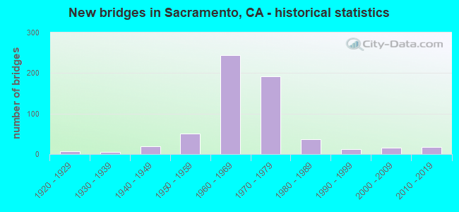
- New bridges - historical statistics
- 11910-1919
- 71920-1929
- 61930-1939
- 191940-1949
- 511950-1959
- 2451960-1969
- 1921970-1979
- 361980-1989
- 131990-1999
- 152000-2009
- 182010-2019

- Reconstructed bridges - Historical Statistics
- 11920-1929
- 01930-1939
- 01940-1949
- 41950-1959
- 151960-1969
- 41970-1979
- 71980-1989
- 81990-1999
- 122000-2009
- 22010-2019


- Bridge Condition - Deck
- 61.5%Good
- 14.3%Satisfactory
- 21.7%Fair
- 2.4%Poor

- Bridge Condition - Superstructure
- 63.4%Good
- 12.7%Satisfactory
- 22.9%Fair
- 1.0%Poor

- Bridge Condition - Substructure
- 0.3%Very good
- 83.2%Good
- 9.6%Satisfactory
- 6.8%Fair

- Bridge Condition - Channel
- 6.3%Excellent
- 53.9%Very good
- 19.5%Good
- 19.5%Satisfactory
- 0.8%Poor

- Bridge Condition - Culverts
- 66.7%Good
- 33.3%Satisfactory
Find on map >> Show street view
Structure Number: 24 0247R, Location: 03-SAC-050-L1.36-SAC (Lat: 38.563444, Lng: -121.493306), Route carried "on" structure: Interstate 50, Year Built: 1967, Status: Open, Structure Length: 16.12m (52.89ft), Average Daily Traffic: 115,500 (year 2009), Truck Traffic: 3%, Average Future Daily Traffic: 127,521 (year 2041), Design Load: HS 20, Features Intersected: 15TH & 16TH STREETS,RAMP
Minimum Vertical Clearance: 30+ m (98+ ft), Kilometerpoint: 1.360, Lanes on structure: 6, Lanes under structure: 13, Base Highway Network: Yes (, Subroute: 1), Owner: State Highway Agency, Approaching Roadway Width: 23.7m (77.8ft), Material/Design: Concrete continuous, Design/Construction: Box Beam or Girders - Multiple, Number Of Spans In Main Unit: 5, Length of Maximum Span: 32.5m (106.6ft), Curb-To-Curb Width: 23.7m (77.8ft), Out-to-Out Width: 24.3m (79.7ft)
Condition: Deck: Good, Superstructure: Fair, Substructure: Good, Operating Rating: 84.6 metric tons, Method Used To Determine Operating Rating: Load Factor (LF), Inventory Rating: 50.9 metric tons, Method Used To Determine Inventory Rating: Load Factor (LF), Structural Evaluation: Somewhat better than minimum adequacy, Deck Geometry: Meets minimum limits, Underclear: Meets minimum limits, Approach Roadway Alignment: Equal to present desirable criteria, Designated Inspection Frequency: Every 24 months, Inspection Date: October 2021, Deck Structure Type: Concrete Cast-file-Place
Find on map >> Show street view
Structure Number: 24 0248L, Location: 03-SAC-050-L1.59-SAC (Lat: 38.562633, Lng: -121.489225), Route carried "on" structure: Interstate 50, Year Built: 1968, Year Reconstructed: 2014, Status: Open, Structure Length: 77.72m (254.99ft), Average Daily Traffic: 123,000 (year 2009), Truck Traffic: 2%, Average Future Daily Traffic: 192,812 (year 2041), Design Load: HS 20, Features Intersected: 18TH TO 24TH,UP,BNSF,LRT
Minimum Vertical Clearance: 30+ m (98+ ft), Kilometerpoint: 1.590, Lanes on structure: 6, Lanes under structure: 15, Base Highway Network: Yes (, Subroute: 1), Owner: State Highway Agency, Approaching Roadway Width: 26.8m (87.9ft), Material/Design: Concrete continuous, Design/Construction: Box Beam or Girders - Multiple, Number Of Spans In Main Unit: 25, Length of Maximum Span: 33.5m (109.9ft), Curb-To-Curb Width: 26.8m (87.9ft), Out-to-Out Width: 27.4m (89.9ft)
Condition: Deck: Fair, Superstructure: Fair, Substructure: Good, Operating Rating: 66.4 metric tons, Method Used To Determine Operating Rating: Load Factor (LF), Inventory Rating: 39.9 metric tons, Method Used To Determine Inventory Rating: Load Factor (LF), Structural Evaluation: Somewhat better than minimum adequacy, Deck Geometry: Somewhat better than minimum adequacy, Underclear: Somewhat better than minimum adequacy, Approach Roadway Alignment: Equal to present desirable criteria, Designated Inspection Frequency: Every 24 months, Inspection Date: October 2021, Deck Structure Type: Concrete Cast-file-Place
Find on map >> Show street view
Structure Number: 24 0248R, Location: 03-SAC-050-L1.59-SAC (Lat: 38.562372, Lng: -121.489336), Route carried "on" structure: Interstate 50, Year Built: 1968, Year Reconstructed: 2014, Status: Open, Structure Length: 77.72m (254.99ft), Average Daily Traffic: 123,000 (year 2009), Truck Traffic: 2%, Average Future Daily Traffic: 192,812 (year 2041), Design Load: HS 20, Features Intersected: 18TH TO 24TH,UP,BNSF,LRT
Minimum Vertical Clearance: 30+ m (98+ ft), Kilometerpoint: 1.590, Lanes on structure: 6, Lanes under structure: 17, Base Highway Network: Yes (, Subroute: 1), Owner: State Highway Agency, Approaching Roadway Width: 26.8m (87.9ft), Material/Design: Concrete continuous, Design/Construction: Box Beam or Girders - Multiple, Number Of Spans In Main Unit: 25, Length of Maximum Span: 33.5m (109.9ft), Curb-To-Curb Width: 26.8m (87.9ft), Out-to-Out Width: 27.4m (89.9ft)
Condition: Deck: Fair, Superstructure: Fair, Substructure: Good, Operating Rating: 66.4 metric tons, Method Used To Determine Operating Rating: Load Factor (LF), Inventory Rating: 39.9 metric tons, Method Used To Determine Inventory Rating: Load Factor (LF), Structural Evaluation: Somewhat better than minimum adequacy, Deck Geometry: Somewhat better than minimum adequacy, Underclear: Somewhat better than minimum adequacy, Approach Roadway Alignment: Equal to present desirable criteria, Designated Inspection Frequency: Every 24 months, Inspection Date: October 2021, Deck Structure Type: Concrete Cast-file-Place
Find on map >> Show street view
Structure Number: 24 0249, Location: 03-SAC-080-M1.36 (Lat: 38.615400, Lng: -121.535789), Route carried "on" structure: County highway , Year Built: 1970, Status: Open, Structure Length: 7.65m (25.10ft), Average Daily Traffic: 40,000 (year 2010), Truck Traffic: 10%, Average Future Daily Traffic: 56,166 (year 2041), Design Load: HS 20, Features Intersected: INTERSTATE 80, Facility Carried by Structure: W EL CAMINO AVE
Minimum Vertical Clearance: 30+ m (98+ ft), Kilometerpoint: 0.000, Lanes on structure: 2, Lanes under structure: 8, Owner: State Highway Agency, Approaching Roadway Width: 12.2m (40.0ft), Skew: 2 degrees, Material/Design: Prestressed concrete continuous, Design/Construction: Box Beam or Girders - Multiple, Number Of Spans In Main Unit: 2, Length of Maximum Span: 38.8m (127.3ft), Curb or Sidewalk Widths: Left: 1.5m (4.9ft), Right: 0.0m, Curb-To-Curb Width: 12.2m (40.0ft), Out-to-Out Width: 14.3m (46.9ft)
Condition: Deck: Fair, Superstructure: Good, Substructure: Good, Operating Rating: 40.5 metric tons, Method Used To Determine Operating Rating: Load and Resistance Factor Rating (LRFR) rating reported by rating factor(RF) method using HL-93 loadings, Inventory Rating: 27.2 metric tons, Method Used To Determine Inventory Rating: Load and Resistance Factor Rating (LRFR) rating reported by rating factor(RF) method using HL-93 loadings, Structural Evaluation: Equal to present minimum criteria, Deck Geometry: Somewhat better than minimum adequacy, Underclear: Better than present minimum criteria, Approach Roadway Alignment: Equal to present desirable criteria, Designated Inspection Frequency: Every 24 months, Inspection Date: January 2021, Deck Structure Type: Concrete Cast-file-Place
Find on map >> Show street view
Structure Number: 24 0250L, Location: 03-SAC-005-24.65-SAC (Lat: 38.596817, Lng: -121.503975), Route carried "on" structure: Interstate 5, Year Built: 1968, Status: Open, Structure Length: 4.15m (13.62ft), Average Daily Traffic: 89,000 (year 2015), Truck Traffic: 10%, Average Future Daily Traffic: 144,182 (year 2038), Design Load: HS 20, Features Intersected: RICHARDS BLVD
Minimum Vertical Clearance: 30+ m (98+ ft), Kilometerpoint: 24.650, Lanes on structure: 4, Lanes under structure: 7, Base Highway Network: Yes (, Subroute: 1), Owner: State Highway Agency, Approaching Roadway Width: 20.1m (65.9ft), Skew: 1 degrees, Material/Design: Prestressed concrete, Design/Construction: Box Beam or Girders - Multiple, Number Of Spans In Main Unit: 1, Length of Maximum Span: 40.8m (133.9ft), Curb-To-Curb Width: 20.1m (65.9ft), Out-to-Out Width: 20.7m (67.9ft)
Condition: Deck: Good, Superstructure: Good, Substructure: Good, Operating Rating: 50.9 metric tons, Method Used To Determine Operating Rating: Load and Resistance Factor Rating (LRFR) rating reported by rating factor(RF) method using HL-93 loadings, Inventory Rating: 31.1 metric tons, Method Used To Determine Inventory Rating: Load and Resistance Factor Rating (LRFR) rating reported by rating factor(RF) method using HL-93 loadings, Structural Evaluation: Better than present minimum criteria, Deck Geometry: Equal to present minimum criteria, Underclear: Equal to present minimum criteria, Approach Roadway Alignment: Equal to present desirable criteria, Designated Inspection Frequency: Every 24 months, Inspection Date: Febuary 2021, Deck Structure Type: Concrete Cast-file-Place
Find on map >> Show street view
Structure Number: 24 0250R, Location: 03-SAC-005-24.65-SAC (Lat: 38.596828, Lng: -121.503672), Route carried "on" structure: Interstate 5, Year Built: 1968, Status: Open, Structure Length: 4.15m (13.62ft), Average Daily Traffic: 89,000 (year 2015), Truck Traffic: 10%, Average Future Daily Traffic: 144,182 (year 2038), Design Load: HS 20, Features Intersected: RICHARDS BLVD
Minimum Vertical Clearance: 30+ m (98+ ft), Kilometerpoint: 24.650, Lanes on structure: 4, Lanes under structure: 7, Base Highway Network: Yes (, Subroute: 1), Owner: State Highway Agency, Approaching Roadway Width: 20.1m (65.9ft), Skew: 1 degrees, Material/Design: Prestressed concrete, Design/Construction: Box Beam or Girders - Multiple, Number Of Spans In Main Unit: 1, Length of Maximum Span: 40.8m (133.9ft), Curb-To-Curb Width: 20.1m (65.9ft), Out-to-Out Width: 20.7m (67.9ft)
Condition: Deck: Good, Superstructure: Good, Substructure: Good, Operating Rating: 50.9 metric tons, Method Used To Determine Operating Rating: Load and Resistance Factor Rating (LRFR) rating reported by rating factor(RF) method using HL-93 loadings, Inventory Rating: 31.1 metric tons, Method Used To Determine Inventory Rating: Load and Resistance Factor Rating (LRFR) rating reported by rating factor(RF) method using HL-93 loadings, Structural Evaluation: Better than present minimum criteria, Deck Geometry: Equal to present minimum criteria, Underclear: Superior to present desirable criteria, Approach Roadway Alignment: Equal to present desirable criteria, Designated Inspection Frequency: Every 24 months, Inspection Date: Febuary 2021, Deck Structure Type: Concrete Cast-file-Place
Find on map >> Show street view
Structure Number: 24 0251, Location: 03-SAC-005-18.65-SAC (Lat: 38.516000, Lng: -121.521775), Route carried "on" structure: Interstate 5, Year Built: 1974, Status: Open, Structure Length: 4.36m (14.30ft), Average Daily Traffic: 117,000 (year 2015), Truck Traffic: 12%, Average Future Daily Traffic: 198,000 (year 2040), Design Load: HS 20, Features Intersected: 43RD AVE
Minimum Vertical Clearance: 30+ m (98+ ft), Kilometerpoint: 18.650, Lanes on structure: 8, Lanes under structure: 5, Base Highway Network: Yes (, Subroute: 1), Owner: State Highway Agency, Approaching Roadway Width: 42.1m (138.1ft), Skew: 30 degrees, Material/Design: Concrete continuous, Design/Construction: Box Beam or Girders - Multiple, Number Of Spans In Main Unit: 2, Length of Maximum Span: 22.6m (74.1ft), Curb-To-Curb Width: 41.2m (135.2ft), Out-to-Out Width: 42.7m (140.1ft)
Condition: Deck: Good, Superstructure: Good, Substructure: Good, Operating Rating: 53.5 metric tons, Method Used To Determine Operating Rating: Load and Resistance Factor Rating (LRFR) rating reported by rating factor(RF) method using HL-93 loadings, Inventory Rating: 41.1 metric tons, Method Used To Determine Inventory Rating: Load and Resistance Factor Rating (LRFR) rating reported by rating factor(RF) method using HL-93 loadings, Structural Evaluation: Better than present minimum criteria, Deck Geometry: Superior to present desirable criteria, Underclear: Somewhat better than minimum adequacy, Approach Roadway Alignment: Equal to present desirable criteria, Designated Inspection Frequency: Every 24 months, Inspection Date: June 2020, Deck Structure Type: Concrete Cast-file-Place, Wearing Surface/Protective System: Wearing Surface: Integral Concrete
Find on map >> Show street view
Structure Number: 24 0252, Location: 03-SAC-005-19.13-SAC (Lat: 38.522942, Lng: -121.521422), Route carried "on" structure: Interstate 5, Year Built: 1974, Status: Open, Structure Length: 3.44m (11.29ft), Average Daily Traffic: 138,000 (year 2015), Truck Traffic: 10%, Average Future Daily Traffic: 221,000 (year 2040), Design Load: HS 20, Features Intersected: 35TH AVE
Minimum Vertical Clearance: 30+ m (98+ ft), Kilometerpoint: 19.130, Lanes on structure: 10, Lanes under structure: 2, Base Highway Network: Yes (, Subroute: 1), Owner: State Highway Agency, Approaching Roadway Width: 45.7m (149.9ft), Skew: 31 degrees, Material/Design: Prestressed concrete, Design/Construction: Box Beam or Girders - Multiple, Number Of Spans In Main Unit: 1, Length of Maximum Span: 33.8m (110.9ft), Curb-To-Curb Width: 50.7m (166.3ft), Out-to-Out Width: 52.2m (171.3ft)
Condition: Deck: Good, Superstructure: Good, Substructure: Good, Operating Rating: 75.5 metric tons, Method Used To Determine Operating Rating: Load Factor (LF), Inventory Rating: 32.4 metric tons, Method Used To Determine Inventory Rating: Load Factor (LF), Structural Evaluation: Better than present minimum criteria, Deck Geometry: Superior to present desirable criteria, Underclear: Equal to present minimum criteria, Approach Roadway Alignment: Equal to present desirable criteria, Designated Inspection Frequency: Every 24 months, Inspection Date: June 2020, Deck Structure Type: Concrete Cast-file-Place, Wearing Surface/Protective System: Wearing Surface: Integral Concrete
Find on map >> Show street view
Structure Number: 24 0253, Location: 03-SAC-005-19.30-SAC (Lat: 38.525392, Lng: -121.521175), Route carried "on" structure: Interstate 5, Year Built: 1974, Status: Open, Structure Length: 4.63m (15.19ft), Average Daily Traffic: 138,000 (year 2015), Truck Traffic: 10%, Average Future Daily Traffic: 221,000 (year 2040), Design Load: HS 20, Features Intersected: SEAMAS AVE
Minimum Vertical Clearance: 30+ m (98+ ft), Kilometerpoint: 19.300, Lanes on structure: 8, Lanes under structure: 5, Base Highway Network: Yes (, Subroute: 1), Owner: State Highway Agency, Approaching Roadway Width: 42.7m (140.1ft), Skew: 30 degrees, Material/Design: Prestressed concrete, Design/Construction: Box Beam or Girders - Multiple, Number Of Spans In Main Unit: 1, Length of Maximum Span: 45.7m (149.9ft), Curb-To-Curb Width: 41.2m (135.2ft), Out-to-Out Width: 42.7m (140.1ft)
Condition: Deck: Good, Superstructure: Good, Substructure: Good, Operating Rating: 96.9 metric tons, Method Used To Determine Operating Rating: Load Factor (LF), Inventory Rating: 32.4 metric tons, Method Used To Determine Inventory Rating: Load Factor (LF), Structural Evaluation: Better than present minimum criteria, Deck Geometry: Superior to present desirable criteria, Underclear: High priority of corrective action, Approach Roadway Alignment: Equal to present desirable criteria, Designated Inspection Frequency: Every 24 months, Inspection Date: June 2020, Deck Structure Type: Concrete Cast-file-Place, Wearing Surface/Protective System: Wearing Surface: Integral Concrete
Find on map >> Show street view
Structure Number: 24 0255, Location: 03-SAC-005-19.95-SAC (Lat: 38.533964, Lng: -121.516939), Route carried "on" structure: Interstate 5, Year Built: 1974, Status: Open, Structure Length: 3.26m (10.70ft), Average Daily Traffic: 138,000 (year 2015), Truck Traffic: 10%, Average Future Daily Traffic: 229,240 (year 2040), Design Load: HS 20, Features Intersected: RIVERSIDE BLVD
Minimum Vertical Clearance: 30+ m (98+ ft), Kilometerpoint: 19.950, Lanes on structure: 8, Lanes under structure: 2, Base Highway Network: Yes (, Subroute: 1), Owner: State Highway Agency, Approaching Roadway Width: 42.1m (138.1ft), Skew: 39 degrees, Material/Design: Prestressed concrete, Design/Construction: Box Beam or Girders - Multiple, Number Of Spans In Main Unit: 1, Length of Maximum Span: 32.0m (105.0ft), Curb-To-Curb Width: 41.5m (136.2ft), Out-to-Out Width: 42.9m (140.7ft)
Condition: Deck: Good, Superstructure: Good, Substructure: Good, Operating Rating: 78.4 metric tons, Method Used To Determine Operating Rating: Load Factor (LF), Inventory Rating: 32.4 metric tons, Method Used To Determine Inventory Rating: Load Factor (LF), Structural Evaluation: Better than present minimum criteria, Deck Geometry: Superior to present desirable criteria, Underclear: Meets minimum limits, Approach Roadway Alignment: Equal to present desirable criteria, Designated Inspection Frequency: Every 24 months, Inspection Date: Febuary 2021, Deck Structure Type: Concrete Cast-file-Place
Find on map >> Show street view
Structure Number: 24 0256, Location: 03-SAC-005-20.53-SAC (Lat: 38.540847, Lng: -121.511181), Route carried "on" structure: City street , Year Built: 1974, Status: Open, Structure Length: 6.43m (21.10ft), Average Daily Traffic: 42,000 (year 2015), Truck Traffic: 10%, Average Future Daily Traffic: 49,725 (year 2041), Design Load: HS 20, Features Intersected: INTERSTATE 5, Facility Carried by Structure: SUTTERVILLE ROAD
Minimum Vertical Clearance: 30+ m (98+ ft), Kilometerpoint: 0.000, Lanes on structure: 3, Lanes under structure: 8, Owner: State Highway Agency, Approaching Roadway Width: 19.5m (64.0ft), Material/Design: Concrete continuous, Design/Construction: Box Beam or Girders - Multiple, Number Of Spans In Main Unit: 2, Length of Maximum Span: 32.6m (107.0ft), Curb or Sidewalk Widths: Left: 1.5m (4.9ft), Right: 0.0m, Curb-To-Curb Width: 19.5m (64.0ft), Out-to-Out Width: 21.6m (70.9ft)
Condition: Deck: Good, Superstructure: Fair, Substructure: Fair, Operating Rating: 61.9 metric tons, Method Used To Determine Operating Rating: Load and Resistance Factor Rating (LRFR) rating reported by rating factor(RF) method using HL-93 loadings, Inventory Rating: 47.6 metric tons, Method Used To Determine Inventory Rating: Load and Resistance Factor Rating (LRFR) rating reported by rating factor(RF) method using HL-93 loadings, Structural Evaluation: Somewhat better than minimum adequacy, Deck Geometry: Superior to present desirable criteria, Underclear: Meets minimum limits, Approach Roadway Alignment: Equal to present desirable criteria, Designated Inspection Frequency: Every 24 months, Inspection Date: Febuary 2021, Deck Structure Type: Concrete Cast-file-Place
Find on map >> Show street view
Structure Number: 24 0258, Location: 03-SAC-005-18.19-SAC (Lat: 38.509139, Lng: -121.522181), Route carried "on" structure: City street , Year Built: 1974, Status: Open, Structure Length: 6.40m (21.00ft), Average Daily Traffic: 8,900 (year 2015), Truck Traffic: 3%, Average Future Daily Traffic: 24,339 (year 2040), Design Load: HS 20, Features Intersected: INTERSTATE 5, Facility Carried by Structure: GLORIA DR
Minimum Vertical Clearance: 30+ m (98+ ft), Kilometerpoint: 0.000, Lanes on structure: 2, Lanes under structure: 8, Owner: State Highway Agency, Approaching Roadway Width: 12.2m (40.0ft), Skew: 2 degrees, Material/Design: Concrete continuous, Design/Construction: Box Beam or Girders - Multiple, Number Of Spans In Main Unit: 2, Length of Maximum Span: 31.7m (104.0ft), Curb or Sidewalk Widths: Left: 1.5m (4.9ft), Right: 1.5m (4.9ft), Curb-To-Curb Width: 12.2m (40.0ft), Out-to-Out Width: 15.8m (51.8ft)
Condition: Deck: Good, Superstructure: Good, Substructure: Good, Operating Rating: 79.4 metric tons, Method Used To Determine Operating Rating: Load and Resistance Factor Rating (LRFR) rating reported by rating factor(RF) method using HL-93 loadings, Inventory Rating: 58.6 metric tons, Method Used To Determine Inventory Rating: Load and Resistance Factor Rating (LRFR) rating reported by rating factor(RF) method using HL-93 loadings, Structural Evaluation: Better than present minimum criteria, Deck Geometry: Somewhat better than minimum adequacy, Underclear: Meets minimum limits, Approach Roadway Alignment: Equal to present desirable criteria, Designated Inspection Frequency: Every 24 months, Inspection Date: June 2020, Deck Structure Type: Concrete Cast-file-Place, Wearing Surface/Protective System: Wearing Surface: Bituminous
Find on map >> Show street view
Structure Number: 24 0259, Location: 03-SAC-005-16.70-SAC (Lat: 38.488781, Lng: -121.514078), Route carried "on" structure: City street , Year Built: 1974, Status: Open, Structure Length: 5.91m (19.39ft), Average Daily Traffic: 9,900 (year 2015), Truck Traffic: 10%, Average Future Daily Traffic: 27,882 (year 2040), Design Load: HS 20, Features Intersected: INTERSTATE 5, Facility Carried by Structure: SOUTH LAND PARK DR
Minimum Vertical Clearance: 30+ m (98+ ft), Kilometerpoint: 0.000, Lanes on structure: 2, Lanes under structure: 6, Owner: State Highway Agency, Approaching Roadway Width: 12.2m (40.0ft), Material/Design: Concrete continuous, Design/Construction: Box Beam or Girders - Multiple, Number Of Spans In Main Unit: 2, Length of Maximum Span: 29.3m (96.1ft), Curb or Sidewalk Widths: Left: 1.5m (4.9ft), Right: 1.5m (4.9ft), Curb-To-Curb Width: 12.2m (40.0ft), Out-to-Out Width: 15.8m (51.8ft)
Condition: Deck: Good, Superstructure: Good, Substructure: Good, Operating Rating: 55.7 metric tons, Method Used To Determine Operating Rating: Load and Resistance Factor Rating (LRFR) rating reported by rating factor(RF) method using HL-93 loadings, Inventory Rating: 42.8 metric tons, Method Used To Determine Inventory Rating: Load and Resistance Factor Rating (LRFR) rating reported by rating factor(RF) method using HL-93 loadings, Structural Evaluation: Better than present minimum criteria, Deck Geometry: Somewhat better than minimum adequacy, Underclear: High priority of corrective action, Approach Roadway Alignment: Equal to present desirable criteria, Designated Inspection Frequency: Every 24 months, Inspection Date: June 2020, Deck Structure Type: Concrete Cast-file-Place
Find on map >> Show street view
Structure Number: 24 0260L, Location: 03-SAC-005-0.71 (Lat: 38.264414, Lng: -121.451708), Route carried "on" structure: Interstate 5, Year Built: 1979, Status: Open, Structure Length: 6.46m (21.19ft), Average Daily Traffic: 26,500 (year 2015), Truck Traffic: 25%, Average Future Daily Traffic: 52,714 (year 2040), Design Load: HS 20, Features Intersected: MIDDLE SLOUGH
Minimum Vertical Clearance: 30+ m (98+ ft), Kilometerpoint: 0.710, Lanes on structure: 2, Base Highway Network: Yes (, Subroute: 1), Owner: State Highway Agency, Approaching Roadway Width: 11.9m (39.0ft), Skew: 1 degrees, Material/Design: Concrete continuous, Design/Construction: Tee Beam, Number Of Spans In Main Unit: 4, Length of Maximum Span: 18.3m (60.0ft), Curb-To-Curb Width: 11.7m (38.4ft), Out-to-Out Width: 12.8m (42.0ft)
Condition: Deck: Good, Superstructure: Good, Substructure: Good, Channel: Very good, Operating Rating: 72.3 metric tons, Method Used To Determine Operating Rating: Load Factor (LF), Inventory Rating: 43.4 metric tons, Method Used To Determine Inventory Rating: Load Factor (LF), Structural Evaluation: Better than present minimum criteria, Deck Geometry: Equal to present minimum criteria, Waterway Adequacy: Equal to present desirable criteria, Approach Roadway Alignment: Equal to present desirable criteria, Designated Inspection Frequency: Every 24 months, Underwater Inspection Frequency: Every 60 months, Inspection Date: April 2020, Underwater Inspection Date: September 2020, Deck Structure Type: Concrete Cast-file-Place
Find on map >> Show street view
Structure Number: 24 0263, Location: 03-SAC-005-16.15-SAC (Lat: 38.481244, Lng: -121.510964), Route carried "on" structure: City street , Year Built: 1974, Status: Open, Structure Length: 7.62m (25.00ft), Average Daily Traffic: 15,500 (year 2015), Truck Traffic: 10%, Average Future Daily Traffic: 43,386 (year 2040), Design Load: HS 20+Mod, Features Intersected: INTERSTATE 5, Facility Carried by Structure: POCKET ROAD
Minimum Vertical Clearance: 30+ m (98+ ft), Kilometerpoint: 0.000, Lanes on structure: 4, Lanes under structure: 8, Owner: State Highway Agency, Approaching Roadway Width: 19.5m (64.0ft), Skew: 2 degrees, Material/Design: Concrete continuous, Design/Construction: Box Beam or Girders - Multiple, Number Of Spans In Main Unit: 2, Length of Maximum Span: 39.3m (128.9ft), Curb or Sidewalk Widths: Left: 1.5m (4.9ft), Right: 1.5m (4.9ft), Curb-To-Curb Width: 19.5m (64.0ft), Out-to-Out Width: 23.2m (76.1ft)
Condition: Deck: Fair, Superstructure: Good, Substructure: Good, Operating Rating: 82.6 metric tons, Method Used To Determine Operating Rating: Load and Resistance Factor Rating (LRFR) rating reported by rating factor(RF) method using HL-93 loadings, Inventory Rating: 60.9 metric tons, Method Used To Determine Inventory Rating: Load and Resistance Factor Rating (LRFR) rating reported by rating factor(RF) method using HL-93 loadings, Structural Evaluation: Better than present minimum criteria, Deck Geometry: Better than present minimum criteria, Underclear: High priority of corrective action, Approach Roadway Alignment: Equal to present desirable criteria, Designated Inspection Frequency: Every 24 months, Inspection Date: June 2020, Deck Structure Type: Concrete Cast-file-Place, Wearing Surface/Protective System: Wearing Surface: Bituminous
Find on map >> Show street view
Structure Number: 24 0264, Location: 03-SAC-005-17.18-SAC (Lat: 38.495444, Lng: -121.516994), Route carried "on" structure: City street , Year Built: 1974, Status: Open, Structure Length: 9.02m (29.59ft), Average Daily Traffic: 45,000 (year 2015), Truck Traffic: 10%, Average Future Daily Traffic: 125,926 (year 2040), Design Load: HS 20, Features Intersected: INTERSTATE 5, Facility Carried by Structure: FLORIN ROAD
Minimum Vertical Clearance: 30+ m (98+ ft), Kilometerpoint: 0.000, Lanes on structure: 6, Lanes under structure: 11, Owner: State Highway Agency, Approaching Roadway Width: 33.5m (109.9ft), Skew: 21 degrees, Material/Design: Prestressed concrete continuous, Design/Construction: Box Beam or Girders - Multiple, Number Of Spans In Main Unit: 2, Length of Maximum Span: 44.8m (147.0ft), Curb or Sidewalk Widths: Left: 1.5m (4.9ft), Right: 1.5m (4.9ft), Curb-To-Curb Width: 33.5m (109.9ft), Out-to-Out Width: 37.2m (122.0ft)
Condition: Deck: Good, Superstructure: Good, Substructure: Good, Operating Rating: 32.4 metric tons, Method Used To Determine Operating Rating: Load and Resistance Factor Rating (LRFR) rating reported by rating factor(RF) method using HL-93 loadings, Inventory Rating: 24.9 metric tons, Method Used To Determine Inventory Rating: Load and Resistance Factor Rating (LRFR) rating reported by rating factor(RF) method using HL-93 loadings, Structural Evaluation: Equal to present minimum criteria, Deck Geometry: Superior to present desirable criteria, Underclear: High priority of corrective action, Approach Roadway Alignment: Equal to present desirable criteria, Designated Inspection Frequency: Every 24 months, Inspection Date: June 2020, Deck Structure Type: Concrete Cast-file-Place, Wearing Surface/Protective System: Wearing Surface: Bituminous
Find on map >> Show street view
Structure Number: 24 0265, Location: 03-SAC-005-17.58-SAC (Lat: 38.501158, Lng: -121.517306), Route carried "on" structure: Interstate 5, Year Built: 1974, Status: Open, Structure Length: 3.05m (10.01ft), Average Daily Traffic: 117,000 (year 2015), Truck Traffic: 12%, Average Future Daily Traffic: 198,000 (year 2040), Design Load: HS 20, Features Intersected: 56TH AVE
Minimum Vertical Clearance: 30+ m (98+ ft), Kilometerpoint: 17.580, Lanes on structure: 10, Lanes under structure: 2, Base Highway Network: Yes (, Subroute: 1), Owner: State Highway Agency, Approaching Roadway Width: 50.6m (166.0ft), Skew: 30 degrees, Material/Design: Prestressed concrete, Design/Construction: Box Beam or Girders - Multiple, Number Of Spans In Main Unit: 1, Length of Maximum Span: 29.9m (98.1ft), Curb-To-Curb Width: 49.9m (163.7ft), Out-to-Out Width: 51.1m (167.7ft)
Condition: Deck: Good, Superstructure: Good, Substructure: Good, Operating Rating: 70.6 metric tons, Method Used To Determine Operating Rating: Load Factor (LF), Inventory Rating: 32.4 metric tons, Method Used To Determine Inventory Rating: Load Factor (LF), Structural Evaluation: Better than present minimum criteria, Deck Geometry: Superior to present desirable criteria, Underclear: Meets minimum limits, Approach Roadway Alignment: Equal to present desirable criteria, Designated Inspection Frequency: Every 24 months, Inspection Date: June 2020, Deck Structure Type: Concrete Cast-file-Place, Wearing Surface/Protective System: Wearing Surface: Bituminous
Find on map >> Show street view
Structure Number: 24 0266, Location: 03-SAC-005-22.25-SAC (Lat: 38.564661, Lng: -121.514050), Route carried "on" structure: Interstate 5, Year Built: 1970, Status: Open, Structure Length: 1.11m (3.64ft), Average Daily Traffic: 138,000 (year 2015), Truck Traffic: 10%, Average Future Daily Traffic: 229,240 (year 2040), Design Load: HS 20, Features Intersected: UP RR SPUR
Minimum Vertical Clearance: 30+ m (98+ ft), Kilometerpoint: 22.250, Lanes on structure: 14, Base Highway Network: Yes (, Subroute: 1), Owner: State Highway Agency, Approaching Roadway Width: 83.2m (273.0ft), Skew: 23 degrees, Material/Design: Concrete, Design/Construction: Slab, Number Of Spans In Main Unit: 1, Length of Maximum Span: 7.6m (24.9ft), Curb-To-Curb Width: 83.2m (273.0ft), Out-to-Out Width: 95.4m (313.0ft)
Condition: Deck: Fair, Superstructure: Fair, Substructure: Good, Operating Rating: 99.8 metric tons, Method Used To Determine Operating Rating: Load Factor (LF), Inventory Rating: 96.2 metric tons, Method Used To Determine Inventory Rating: Load Factor (LF), Structural Evaluation: Somewhat better than minimum adequacy, Deck Geometry: Superior to present desirable criteria, Underclear: Meets minimum limits, Approach Roadway Alignment: Equal to present desirable criteria, Length Of Structure Improvement: 1.10m (3.61ft), Designated Inspection Frequency: Every 24 months, Inspection Date: Febuary 2021, Deck Structure Type: Concrete Cast-file-Place
Find on map >> Show street view
Structure Number: 24 0267, Location: 03-SAC-005-22.42-SAC (Lat: 38.566750, Lng: -121.512272), Route carried "on" structure: Interstate 5, Year Built: 1971, Status: Open, Structure Length: 10.61m (34.81ft), Average Daily Traffic: 138,000 (year 2015), Truck Traffic: 10%, Average Future Daily Traffic: 229,240 (year 2040), Design Load: HS 20, Features Intersected: S5-E50 CONN RP, BROADWAY
Minimum Vertical Clearance: 30+ m (98+ ft), Kilometerpoint: 22.420, Lanes on structure: 7, Lanes under structure: 5, Base Highway Network: Yes (, Subroute: 1), Owner: State Highway Agency, Approaching Roadway Width: 42.7m (140.1ft), Skew: 39 degrees, Material/Design: Steel, Design/Construction: Stringer/Multi-beam, Number Of Spans In Main Unit: 4, Length of Maximum Span: 37.0m (121.4ft), Curb-To-Curb Width: 42.4m (139.1ft), Out-to-Out Width: 43.3m (142.1ft)
Condition: Deck: Good, Superstructure: Good, Substructure: Good, Operating Rating: 46.3 metric tons, Method Used To Determine Operating Rating: Load Factor (LF), Inventory Rating: 27.9 metric tons, Method Used To Determine Inventory Rating: Load Factor (LF), Structural Evaluation: Better than present minimum criteria, Deck Geometry: Superior to present desirable criteria, Underclear: Meets minimum limits, Approach Roadway Alignment: Equal to present desirable criteria, Designated Inspection Frequency: Every 24 months, Critical Feature Inspection Frequency: Every 24 months, Inspection Date: Febuary 2021, Critical Feature Inspection Date: October 2021, Deck Structure Type: Concrete Cast-file-Place
Find on map >> Show street view
Structure Number: 24 0268G, Location: 03-SAC-005-22.41-SAC (Lat: 38.566631, Lng: -121.512125), Route carried "on" structure: Ramp Interstate 5, Year Built: 1971, Status: Open, Structure Length: 15.00m (49.21ft), Average Daily Traffic: 16,000 (year 2015), Truck Traffic: 2%, Average Future Daily Traffic: 27,533 (year 2041), Design Load: HS 20+Mod, Features Intersected: S5-E50 CONN RP, BROADWAY
Minimum Vertical Clearance: 30+ m (98+ ft), Kilometerpoint: 22.410, Lanes on structure: 2, Lanes under structure: 5, Owner: State Highway Agency, Approaching Roadway Width: 8.5m (27.9ft), Material/Design: Steel continuous, Design/Construction: Stringer/Multi-beam, Number Of Spans In Main Unit: 5, Length of Maximum Span: 42.7m (140.1ft), Curb-To-Curb Width: 9.8m (32.2ft), Out-to-Out Width: 10.4m (34.1ft)
Condition: Deck: Good, Superstructure: Good, Substructure: Good, Operating Rating: 37.9 metric tons, Method Used To Determine Operating Rating: Load and Resistance Factor Rating (LRFR) rating reported by rating factor(RF) method using HL-93 loadings, Inventory Rating: 29.2 metric tons, Method Used To Determine Inventory Rating: Load and Resistance Factor Rating (LRFR) rating reported by rating factor(RF) method using HL-93 loadings, Structural Evaluation: Better than present minimum criteria, Deck Geometry: Equal to present minimum criteria, Underclear: Meets minimum limits, Approach Roadway Alignment: Equal to present desirable criteria, Designated Inspection Frequency: Every 24 months, Critical Feature Inspection Frequency: Every 24 months, Inspection Date: Febuary 2021, Critical Feature Inspection Date: October 2021, Deck Structure Type: Concrete Cast-file-Place
Find on map >> Show street view
Structure Number: 24 0269G, Location: 03-SAC-005-22.41-SAC (Lat: 38.566447, Lng: -121.512006), Route carried "on" structure: Ramp Interstate 5, Year Built: 1971, Status: Open, Structure Length: 14.54m (47.70ft), Average Daily Traffic: 24,000 (year 2015), Truck Traffic: 2%, Average Future Daily Traffic: 27,533 (year 2041), Design Load: HS 20+Mod, Features Intersected: S5-E50 CONN RP, BROADWAY
Minimum Vertical Clearance: 30+ m (98+ ft), Kilometerpoint: 22.410, Lanes on structure: 2, Lanes under structure: 5, Owner: State Highway Agency, Approaching Roadway Width: 8.8m (28.9ft), Material/Design: Steel continuous, Design/Construction: Stringer/Multi-beam, Number Of Spans In Main Unit: 4, Length of Maximum Span: 42.7m (140.1ft), Curb-To-Curb Width: 9.8m (32.2ft), Out-to-Out Width: 10.4m (34.1ft)
Condition: Deck: Good, Superstructure: Good, Substructure: Good, Operating Rating: 37.9 metric tons, Method Used To Determine Operating Rating: Load and Resistance Factor Rating (LRFR) rating reported by rating factor(RF) method using HL-93 loadings, Inventory Rating: 29.2 metric tons, Method Used To Determine Inventory Rating: Load and Resistance Factor Rating (LRFR) rating reported by rating factor(RF) method using HL-93 loadings, Structural Evaluation: Better than present minimum criteria, Deck Geometry: Equal to present minimum criteria, Underclear: Equal to present minimum criteria, Approach Roadway Alignment: Equal to present desirable criteria, Designated Inspection Frequency: Every 24 months, Critical Feature Inspection Frequency: Every 24 months, Inspection Date: Febuary 2021, Critical Feature Inspection Date: October 2021, Deck Structure Type: Concrete Cast-file-Place
Find on map >> Show street view
Structure Number: 24 0270H, Location: 03-SAC-005-22.50-SAC (Lat: 38.567042, Lng: -121.508794), Route carried "on" structure: Ramp Interstate 5, Year Built: 1971, Status: Open, Structure Length: 20.88m (68.50ft), Average Daily Traffic: 70,000 (year 2015), Truck Traffic: 2%, Average Future Daily Traffic: 85,903 (year 2041), Design Load: HS 20+Mod, Features Intersected: 3RD ST, OFFRAMP & 5TH ST
Minimum Vertical Clearance: 30+ m (98+ ft), Kilometerpoint: 22.500, Lanes on structure: 3, Lanes under structure: 8, Owner: State Highway Agency, Approaching Roadway Width: 20.4m (66.9ft), Skew: 19 degrees, Material/Design: Steel, Design/Construction: Stringer/Multi-beam, Number Of Spans In Main Unit: 5, Length of Maximum Span: 42.7m (140.1ft), Curb-To-Curb Width: 14.6m (47.9ft), Out-to-Out Width: 15.2m (49.9ft)
Condition: Deck: Good, Superstructure: Good, Substructure: Good, Operating Rating: 44.1 metric tons, Method Used To Determine Operating Rating: Load and Resistance Factor Rating (LRFR) rating reported by rating factor(RF) method using HL-93 loadings, Inventory Rating: 34.0 metric tons, Method Used To Determine Inventory Rating: Load and Resistance Factor Rating (LRFR) rating reported by rating factor(RF) method using HL-93 loadings, Structural Evaluation: Better than present minimum criteria, Deck Geometry: Better than present minimum criteria, Underclear: Meets minimum limits, Approach Roadway Alignment: Equal to present desirable criteria, Designated Inspection Frequency: Every 24 months, Critical Feature Inspection Frequency: Every 24 months, Other Special Inspection Frequency: Every 48 months, Inspection Date: Febuary 2021, Critical Feature Inspection Date: October 2021, Other Special Inspection Date: October 2021, Deck Structure Type: Concrete Cast-file-Place
Find on map >> Show street view
Structure Number: 24 0271K, Location: 03-SAC-005-23.10-SAC (Lat: 38.576386, Lng: -121.508519), Route carried "on" structure: Ramp Interstate 5, Year Built: 1970, Status: Open, Structure Length: 6.77m (22.21ft), Average Daily Traffic: 3,950 (year 2015), Truck Traffic: 2%, Average Future Daily Traffic: 4,371 (year 2041), Design Load: HS 20, Features Intersected: INTERSTATE 5 & RAMPS
Minimum Vertical Clearance: 30+ m (98+ ft), Kilometerpoint: 23.100, Lanes on structure: 2, Lanes under structure: 10, Owner: State Highway Agency, Approaching Roadway Width: 9.8m (32.2ft), Skew: 9 degrees, Material/Design: Prestressed concrete continuous, Design/Construction: Box Beam or Girders - Multiple, Number Of Spans In Main Unit: 2, Length of Maximum Span: 39.3m (128.9ft), Curb-To-Curb Width: 9.8m (32.2ft), Out-to-Out Width: 10.4m (34.1ft)
Condition: Deck: Good, Superstructure: Good, Substructure: Good, Operating Rating: 43.7 metric tons, Method Used To Determine Operating Rating: Load and Resistance Factor Rating (LRFR) rating reported by rating factor(RF) method using HL-93 loadings, Inventory Rating: 33.7 metric tons, Method Used To Determine Inventory Rating: Load and Resistance Factor Rating (LRFR) rating reported by rating factor(RF) method using HL-93 loadings, Structural Evaluation: Better than present minimum criteria, Deck Geometry: Equal to present minimum criteria, Underclear: Equal to present minimum criteria, Approach Roadway Alignment: Equal to present minimum criteria, Designated Inspection Frequency: Every 24 months, Inspection Date: Febuary 2021, Deck Structure Type: Concrete Cast-file-Place
Find on map >> Show street view
Structure Number: 24 0272K, Location: 03-SAC-005-23.18-SAC (Lat: 38.576242, Lng: -121.508592), Route carried "on" structure: Ramp Interstate 5, Year Built: 1970, Status: Open, Structure Length: 9.02m (29.59ft), Average Daily Traffic: 8,050 (year 2015), Truck Traffic: 2%, Average Future Daily Traffic: 8,534 (year 2041), Design Load: HS 20, Features Intersected: INTERSTATE 5 & RAMP
Minimum Vertical Clearance: 30+ m (98+ ft), Kilometerpoint: 23.180, Lanes on structure: 2, Lanes under structure: 10, Owner: State Highway Agency, Approaching Roadway Width: 9.8m (32.2ft), Skew: 9 degrees, Material/Design: Prestressed concrete continuous, Design/Construction: Box Beam or Girders - Multiple, Number Of Spans In Main Unit: 3, Length of Maximum Span: 31.7m (104.0ft), Curb-To-Curb Width: 9.8m (32.2ft), Out-to-Out Width: 10.4m (34.1ft)
Condition: Deck: Good, Superstructure: Good, Substructure: Good, Operating Rating: 99.8 metric tons, Method Used To Determine Operating Rating: Load Factor (LF), Inventory Rating: 32.4 metric tons, Method Used To Determine Inventory Rating: Load Factor (LF), Structural Evaluation: Better than present minimum criteria, Deck Geometry: Equal to present minimum criteria, Underclear: High priority of corrective action, Approach Roadway Alignment: Equal to present minimum criteria, Designated Inspection Frequency: Every 24 months, Inspection Date: Febuary 2021, Deck Structure Type: Concrete Cast-file-Place
Find on map >> Show street view
Structure Number: 24 0273, Location: 03-SAC-005-23.26-SAC (Lat: 38.577908, Lng: -121.507731), Route carried "on" structure: City street , Year Built: 1970, Year Reconstructed: 2016, Status: Open, Structure Length: 6.83m (22.41ft), Average Daily Traffic: 2,200 (year 2015), Truck Traffic: 2%, Average Future Daily Traffic: 2,601 (year 2041), Design Load: HS 20, Features Intersected: INTERSTATE 5 & RAMPS, Facility Carried by Structure: "O" ST
Minimum Vertical Clearance: 30+ m (98+ ft), Kilometerpoint: 0.000, Lanes on structure: 2, Lanes under structure: 12, Owner: State Highway Agency, Approaching Roadway Width: 14.6m (47.9ft), Skew: 9 degrees, Material/Design: Prestressed concrete continuous, Design/Construction: Box Beam or Girders - Multiple, Number Of Spans In Main Unit: 2, Length of Maximum Span: 33.8m (110.9ft), Curb or Sidewalk Widths: Left: 2.2m (7.2ft), Right: 3.6m (11.8ft), Curb-To-Curb Width: 9.4m (30.8ft), Out-to-Out Width: 16.0m (52.5ft)
Condition: Deck: Good, Superstructure: Good, Substructure: Good, Operating Rating: 37.9 metric tons, Method Used To Determine Operating Rating: Load and Resistance Factor Rating (LRFR) rating reported by rating factor(RF) method using HL-93 loadings, Inventory Rating: 24.0 metric tons, Method Used To Determine Inventory Rating: Load and Resistance Factor Rating (LRFR) rating reported by rating factor(RF) method using HL-93 loadings, Structural Evaluation: Equal to present minimum criteria, Deck Geometry: Meets minimum limits, Underclear: High priority of corrective action, Approach Roadway Alignment: Equal to present desirable criteria, Designated Inspection Frequency: Every 24 months, Inspection Date: Febuary 2021, Deck Structure Type: Concrete Cast-file-Place
Find on map >> Show street view
Structure Number: 24 0276Y, Location: 03-SAC-080-M8.59-SAC (Lat: 38.633933, Lng: -121.412050), Route carried "on" structure: Interstate 80, Year Built: 1970, Status: Open, Structure Length: 56.30m (184.71ft), Average Daily Traffic: 30 (year 2010), Average Future Daily Traffic: 47 (year 2041), Design Load: HS 20, Features Intersected: UP,BNSF,AMTRAK,ROSEVILLE, Facility Carried by Structure: LRT FACILITY ACCES
Minimum Vertical Clearance: 30+ m (98+ ft), Kilometerpoint: 8.590, Lanes on structure: 4, Lanes under structure: 2, Base Highway Network: Yes (, Subroute: 1), Owner: State Highway Agency, Approaching Roadway Width: 19.2m (63.0ft), Skew: 9 degrees, Material/Design: Prestressed concrete continuous, Design/Construction: Box Beam or Girders - Multiple, Number Of Spans In Main Unit: 3, Number Of Approach Spans: 12, Length of Maximum Span: 55.5m (182.1ft), Curb-To-Curb Width: 19.2m (63.0ft), Out-to-Out Width: 19.8m (65.0ft)
Condition: Deck: Good, Superstructure: Fair, Substructure: Fair, Operating Rating: 31.1 metric tons, Method Used To Determine Operating Rating: Load and Resistance Factor Rating (LRFR) rating reported by rating factor(RF) method using HL-93 loadings, Inventory Rating: 18.5 metric tons, Method Used To Determine Inventory Rating: Load and Resistance Factor Rating (LRFR) rating reported by rating factor(RF) method using HL-93 loadings, Structural Evaluation: Meets minimum limits, Deck Geometry: Somewhat better than minimum adequacy, Underclear: Meets minimum limits, Approach Roadway Alignment: Equal to present desirable criteria, Designated Inspection Frequency: Every 24 months, Inspection Date: January 2021, Deck Structure Type: Concrete Cast-file-Place
Find on map >> Show street view
Structure Number: 24 028, Location: 03-SAC-005-3.14 (Lat: 38.298792, Lng: -121.461353), Route carried "on" structure: County highway , Year Built: 1979, Status: Open, Structure Length: 7.25m (23.79ft), Average Daily Traffic: 1,000 (year 2015), Truck Traffic: 3%, Average Future Daily Traffic: 3,217 (year 2040), Design Load: HS 20, Features Intersected: INTERSTATE 5, Facility Carried by Structure: DIERSSEN ROAD
Minimum Vertical Clearance: 30+ m (98+ ft), Kilometerpoint: 0.000, Lanes on structure: 2, Lanes under structure: 4, Owner: State Highway Agency, Approaching Roadway Width: 9.8m (32.2ft), Skew: 1 degrees, Material/Design: Concrete continuous, Design/Construction: Box Beam or Girders - Multiple, Number Of Spans In Main Unit: 2, Length of Maximum Span: 36.0m (118.1ft), Curb-To-Curb Width: 9.8m (32.2ft), Out-to-Out Width: 10.8m (35.4ft)
Condition: Deck: Fair, Superstructure: Fair, Substructure: Good, Operating Rating: 47.6 metric tons, Method Used To Determine Operating Rating: Load and Resistance Factor Rating (LRFR) rating reported by rating factor(RF) method using HL-93 loadings, Inventory Rating: 34.0 metric tons, Method Used To Determine Inventory Rating: Load and Resistance Factor Rating (LRFR) rating reported by rating factor(RF) method using HL-93 loadings, Structural Evaluation: Somewhat better than minimum adequacy, Deck Geometry: Equal to present minimum criteria, Underclear: Equal to present minimum criteria, Approach Roadway Alignment: Equal to present desirable criteria, Designated Inspection Frequency: Every 24 months, Inspection Date: April 2020, Deck Structure Type: Concrete Cast-file-Place
Find on map >> Show street view
Structure Number: 24 0281K, Location: 03-SAC-080-M9.15-SAC (Lat: 38.638692, Lng: -121.403092), Route carried "on" structure: Ramp Interstate 80, Year Built: 1970, Status: Open, Structure Length: 19.05m (62.50ft), Average Daily Traffic: 7,500 (year 2010), Truck Traffic: 7%, Average Future Daily Traffic: 10,724 (year 2041), Design Load: HS 20+Mod, Features Intersected: W80-LIGHT RAIL PARKING
Minimum Vertical Clearance: 30+ m (98+ ft), Kilometerpoint: 9.150, Lanes on structure: 2, Lanes under structure: 6, Owner: State Highway Agency, Approaching Roadway Width: 9.8m (32.2ft), Material/Design: Prestressed concrete continuous, Design/Construction: Box Beam or Girders - Multiple, Number Of Spans In Main Unit: 2, Number Of Approach Spans: 2, Length of Maximum Span: 60.4m (198.2ft), Curb-To-Curb Width: 7.6m (24.9ft), Out-to-Out Width: 8.2m (26.9ft)
Condition: Deck: Poor, Superstructure: Fair, Substructure: Good, Operating Rating: 39.2 metric tons, Method Used To Determine Operating Rating: Load and Resistance Factor Rating (LRFR) rating reported by rating factor(RF) method using HL-93 loadings, Inventory Rating: 30.5 metric tons, Method Used To Determine Inventory Rating: Load and Resistance Factor Rating (LRFR) rating reported by rating factor(RF) method using HL-93 loadings, Structural Evaluation: Somewhat better than minimum adequacy, Deck Geometry: High priority of replacement, Underclear: Superior to present desirable criteria, Approach Roadway Alignment: Equal to present desirable criteria, Length Of Structure Improvement: 19.05m (62.50ft), Designated Inspection Frequency: Every 24 months, Inspection Date: January 2021, Bridge Improvement Cost: $1,812,000, Roadway Improvement Cost: $362,000, Total Project Cost: $3,044,000 ( Estimate for 2017), Deck Structure Type: Concrete Cast-file-Place
Find on map >> Show street view
Structure Number: 24 0282S, Location: 03-SAC-080-M9.19-SAC (Lat: 38.637589, Lng: -121.402008), Route carried "on" structure: Bypass Interstate 80, Year Built: 1970, Status: Open, Structure Length: 14.14m (46.39ft), Average Daily Traffic: 11,000 (year 2010), Truck Traffic: 2%, Average Future Daily Traffic: 16,086 (year 2041), Design Load: HS 20, Features Intersected: LRT PARKING-E80 ON-RAMP
Minimum Vertical Clearance: 30+ m (98+ ft), Kilometerpoint: 9.190, Lanes on structure: 2, Lanes under structure: 1, Base Highway Network: Yes (, Subroute: 1), Owner: State Highway Agency, Approaching Roadway Width: 10.4m (34.1ft), Material/Design: Prestressed concrete continuous, Design/Construction: Box Beam or Girders - Multiple, Number Of Spans In Main Unit: 3, Length of Maximum Span: 59.1m (193.9ft), Curb-To-Curb Width: 9.8m (32.2ft), Out-to-Out Width: 10.4m (34.1ft)
Condition: Deck: Fair, Superstructure: Good, Substructure: Good, Operating Rating: 34.7 metric tons, Method Used To Determine Operating Rating: Load and Resistance Factor Rating (LRFR) rating reported by rating factor(RF) method using HL-93 loadings, Inventory Rating: 26.6 metric tons, Method Used To Determine Inventory Rating: Load and Resistance Factor Rating (LRFR) rating reported by rating factor(RF) method using HL-93 loadings, Structural Evaluation: Equal to present minimum criteria, Deck Geometry: Meets minimum limits, Underclear: High priority of corrective action, Approach Roadway Alignment: Equal to present desirable criteria, Designated Inspection Frequency: Every 24 months, Inspection Date: January 2021, Deck Structure Type: Concrete Cast-file-Place
Find on map >> Show street view
Structure Number: 24 0283, Location: 03-SAC-080-M9.40-SAC (Lat: 38.640633, Lng: -121.399608), Route carried "on" structure: City street , Year Built: 1970, Status: Open, Structure Length: 14.97m (49.11ft), Average Daily Traffic: 7,500 (year 2010), Truck Traffic: 15%, Average Future Daily Traffic: 10,724 (year 2041), Design Load: HS 20, Features Intersected: I 80, RAMPS, LRT, Facility Carried by Structure: LONGVIEW DR
Minimum Vertical Clearance: 30+ m (98+ ft), Kilometerpoint: 0.000, Lanes on structure: 4, Lanes under structure: 16, Owner: State Highway Agency, Approaching Roadway Width: 21.3m (69.9ft), Skew: 2 degrees, Material/Design: Prestressed concrete continuous, Design/Construction: Box Beam or Girders - Multiple, Number Of Spans In Main Unit: 3, Length of Maximum Span: 55.3m (181.4ft), Curb or Sidewalk Widths: Left: 0.0m, Right: 1.5m (4.9ft), Curb-To-Curb Width: 19.5m (64.0ft), Out-to-Out Width: 21.6m (70.9ft)
Condition: Deck: Good, Superstructure: Satisfactory, Substructure: Good, Operating Rating: 58.3 metric tons, Method Used To Determine Operating Rating: Load and Resistance Factor Rating (LRFR) rating reported by rating factor(RF) method using HL-93 loadings, Inventory Rating: 37.9 metric tons, Method Used To Determine Inventory Rating: Load and Resistance Factor Rating (LRFR) rating reported by rating factor(RF) method using HL-93 loadings, Structural Evaluation: Equal to present minimum criteria, Deck Geometry: Better than present minimum criteria, Underclear: Meets minimum limits, Approach Roadway Alignment: Equal to present desirable criteria, Designated Inspection Frequency: Every 24 months, Inspection Date: January 2021, Deck Structure Type: Concrete Cast-file-Place, Wearing Surface/Protective System: Wearing Surface: Epoxy Overlay
Find on map >> Show street view
Structure Number: 24 0285, Location: 03-SAC-051-3.36-SAC (Lat: 38.596994, Lng: -121.443922), Route carried "on" structure: City street , Year Built: 1968, Status: Open, Structure Length: 6.68m (21.92ft), Average Daily Traffic: 20,000 (year 2010), Truck Traffic: 10%, Average Future Daily Traffic: 22,131 (year 2039), Design Load: HS 20+Mod, Features Intersected: STATE ROUTE 51, Facility Carried by Structure: EXPOSITION BLVD
Minimum Vertical Clearance: 30+ m (98+ ft), Kilometerpoint: 0.000, Lanes on structure: 5, Lanes under structure: 9, Base Highway Network: Yes, Owner: State Highway Agency, Approaching Roadway Width: 20.8m (68.2ft), Skew: 30 degrees, Material/Design: Prestressed concrete continuous, Design/Construction: Stringer/Multi-beam, Number Of Spans In Main Unit: 2, Length of Maximum Span: 34.7m (113.8ft), Curb or Sidewalk Widths: Left: 1.5m (4.9ft), Right: 0.0m, Curb-To-Curb Width: 20.8m (68.2ft), Out-to-Out Width: 24.1m (79.1ft)
Condition: Deck: Fair, Superstructure: Good, Substructure: Fair, Operating Rating: 85.2 metric tons, Method Used To Determine Operating Rating: Load Factor (LF), Inventory Rating: 32.4 metric tons, Method Used To Determine Inventory Rating: Load Factor (LF), Structural Evaluation: Somewhat better than minimum adequacy, Deck Geometry: Somewhat better than minimum adequacy, Underclear: Equal to present minimum criteria, Approach Roadway Alignment: Equal to present desirable criteria, Designated Inspection Frequency: Every 24 months, Inspection Date: November 2021, Deck Structure Type: Concrete Cast-file-Place
Find on map >> Show street view
Structure Number: 24 0286L, Location: 03-SAC-050-R3.47-SAC (Lat: 38.552939, Lng: -121.412917), Route carried "on" structure: US 50, Year Built: 1971, Status: Open, Structure Length: 3.71m (12.17ft), Average Daily Traffic: 115,500 (year 2017), Truck Traffic: 3%, Average Future Daily Traffic: 151,428 (year 2041), Design Load: HS 20, Features Intersected: HORNET DRIVE
Minimum Vertical Clearance: 30+ m (98+ ft), Kilometerpoint: 3.470, Lanes on structure: 5, Lanes under structure: 4, Base Highway Network: Yes (, Subroute: 1), Owner: State Highway Agency, Approaching Roadway Width: 29.3m (96.1ft), Material/Design: Prestressed concrete, Design/Construction: Box Beam or Girders - Multiple, Number Of Spans In Main Unit: 1, Length of Maximum Span: 36.6m (120.1ft), Curb-To-Curb Width: 29.3m (96.1ft), Out-to-Out Width: 29.9m (98.1ft)
Condition: Deck: Fair, Superstructure: Fair, Substructure: Good, Operating Rating: 50.2 metric tons, Method Used To Determine Operating Rating: Load and Resistance Factor Rating (LRFR) rating reported by rating factor(RF) method using HL-93 loadings, Inventory Rating: 35.0 metric tons, Method Used To Determine Inventory Rating: Load and Resistance Factor Rating (LRFR) rating reported by rating factor(RF) method using HL-93 loadings, Structural Evaluation: Somewhat better than minimum adequacy, Deck Geometry: Superior to present desirable criteria, Underclear: Meets minimum limits, Approach Roadway Alignment: Equal to present desirable criteria, Designated Inspection Frequency: Every 24 months, Inspection Date: November 2021, Deck Structure Type: Concrete Cast-file-Place, Wearing Surface/Protective System: Wearing Surface: Bituminous
Find on map >> Show street view
Structure Number: 24 0286R, Location: 03-SAC-050-R3.47-SAC (Lat: 38.552706, Lng: -121.412864), Route carried "on" structure: US 50, Year Built: 1971, Status: Open, Structure Length: 3.71m (12.17ft), Average Daily Traffic: 115,500 (year 2017), Truck Traffic: 3%, Average Future Daily Traffic: 151,428 (year 2041), Design Load: HS 20, Features Intersected: HORNET DRIVE
Minimum Vertical Clearance: 30+ m (98+ ft), Kilometerpoint: 3.470, Lanes on structure: 4, Lanes under structure: 4, Base Highway Network: Yes (, Subroute: 1), Owner: State Highway Agency, Approaching Roadway Width: 20.1m (65.9ft), Material/Design: Prestressed concrete, Design/Construction: Box Beam or Girders - Multiple, Number Of Spans In Main Unit: 1, Length of Maximum Span: 36.6m (120.1ft), Curb-To-Curb Width: 20.1m (65.9ft), Out-to-Out Width: 20.7m (67.9ft)
Condition: Deck: Fair, Superstructure: Good, Substructure: Good, Operating Rating: 49.9 metric tons, Method Used To Determine Operating Rating: Load and Resistance Factor Rating (LRFR) rating reported by rating factor(RF) method using HL-93 loadings, Inventory Rating: 34.7 metric tons, Method Used To Determine Inventory Rating: Load and Resistance Factor Rating (LRFR) rating reported by rating factor(RF) method using HL-93 loadings, Structural Evaluation: Better than present minimum criteria, Deck Geometry: Equal to present minimum criteria, Underclear: Meets minimum limits, Approach Roadway Alignment: Equal to present desirable criteria, Designated Inspection Frequency: Every 24 months, Inspection Date: November 2021, Deck Structure Type: Concrete Cast-file-Place, Wearing Surface/Protective System: Wearing Surface: Bituminous
Find on map >> Show street view
Structure Number: 24 0286S, Location: 03-SAC-050-R3.47-SAC (Lat: 38.552489, Lng: -121.412806), Route carried "on" structure: Ramp US 50, Year Built: 1971, Status: Open, Structure Length: 3.71m (12.17ft), Average Daily Traffic: 26,000 (year 2017), Truck Traffic: 8%, Average Future Daily Traffic: 32,712 (year 2041), Design Load: HS 20, Features Intersected: HORNET DRIVE
Minimum Vertical Clearance: 30+ m (98+ ft), Kilometerpoint: 3.470, Lanes on structure: 2, Lanes under structure: 4, Owner: State Highway Agency, Approaching Roadway Width: 11.2m (36.7ft), Material/Design: Prestressed concrete, Design/Construction: Box Beam or Girders - Multiple, Number Of Spans In Main Unit: 1, Length of Maximum Span: 36.6m (120.1ft), Curb-To-Curb Width: 11.0m (36.1ft), Out-to-Out Width: 11.6m (38.1ft)
Condition: Deck: Good, Superstructure: Good, Substructure: Good, Operating Rating: 48.0 metric tons, Method Used To Determine Operating Rating: Load and Resistance Factor Rating (LRFR) rating reported by rating factor(RF) method using HL-93 loadings, Inventory Rating: 32.4 metric tons, Method Used To Determine Inventory Rating: Load and Resistance Factor Rating (LRFR) rating reported by rating factor(RF) method using HL-93 loadings, Structural Evaluation: Better than present minimum criteria, Deck Geometry: Better than present minimum criteria, Underclear: Meets minimum limits, Approach Roadway Alignment: Equal to present desirable criteria, Designated Inspection Frequency: Every 24 months, Inspection Date: November 2021, Deck Structure Type: Concrete Cast-file-Place
Find on map >> Show street view
Structure Number: 24 0288L, Location: 03-SAC-050-R3.13-SAC (Lat: 38.551564, Lng: -121.418967), Route carried "on" structure: US 50, Year Built: 1971, Status: Open, Structure Length: 5.66m (18.57ft), Average Daily Traffic: 120,000 (year 2017), Truck Traffic: 3%, Average Future Daily Traffic: 151,428 (year 2041), Design Load: HS 20, Features Intersected: FOLSOM BLVD
Minimum Vertical Clearance: 30+ m (98+ ft), Kilometerpoint: 3.130, Lanes on structure: 5, Lanes under structure: 3, Base Highway Network: Yes (, Subroute: 1), Owner: State Highway Agency, Approaching Roadway Width: 20.1m (65.9ft), Skew: 5 degrees, Material/Design: Prestressed concrete, Design/Construction: Box Beam or Girders - Multiple, Number Of Spans In Main Unit: 1, Length of Maximum Span: 56.1m (184.1ft), Curb-To-Curb Width: 26.6m (87.3ft), Out-to-Out Width: 27.2m (89.2ft)
Condition: Deck: Good, Superstructure: Satisfactory, Substructure: Good, Operating Rating: 99.8 metric tons, Method Used To Determine Operating Rating: Load Factor (LF), Inventory Rating: 32.4 metric tons, Method Used To Determine Inventory Rating: Load Factor (LF), Structural Evaluation: Equal to present minimum criteria, Deck Geometry: Superior to present desirable criteria, Underclear: Meets minimum limits, Approach Roadway Alignment: Equal to present desirable criteria, Designated Inspection Frequency: Every 24 months, Inspection Date: November 2021, Deck Structure Type: Concrete Cast-file-Place
Find on map >> Show street view
Structure Number: 24 0288R, Location: 03-SAC-050-R3.13-SAC (Lat: 38.551431, Lng: -121.418361), Route carried "on" structure: US 50, Year Built: 1971, Status: Open, Structure Length: 5.66m (18.57ft), Average Daily Traffic: 115,500 (year 2017), Truck Traffic: 3%, Average Future Daily Traffic: 151,428 (year 2041), Design Load: HS 20, Features Intersected: FOLSOM BLVD
Minimum Vertical Clearance: 30+ m (98+ ft), Kilometerpoint: 3.130, Lanes on structure: 5, Lanes under structure: 3, Base Highway Network: Yes (, Subroute: 1), Owner: State Highway Agency, Approaching Roadway Width: 20.1m (65.9ft), Skew: 5 degrees, Material/Design: Prestressed concrete, Design/Construction: Box Beam or Girders - Multiple, Number Of Spans In Main Unit: 1, Length of Maximum Span: 56.1m (184.1ft), Curb-To-Curb Width: 23.2m (76.1ft), Out-to-Out Width: 23.8m (78.1ft)
Condition: Deck: Good, Superstructure: Satisfactory, Substructure: Good, Operating Rating: 98.2 metric tons, Method Used To Determine Operating Rating: Load Factor (LF), Inventory Rating: 32.4 metric tons, Method Used To Determine Inventory Rating: Load Factor (LF), Structural Evaluation: Equal to present minimum criteria, Deck Geometry: Somewhat better than minimum adequacy, Underclear: Meets minimum limits, Approach Roadway Alignment: Equal to present desirable criteria, Designated Inspection Frequency: Every 24 months, Inspection Date: November 2021, Deck Structure Type: Concrete Cast-file-Place
Find on map >> Show street view
Structure Number: 24 0289L, Location: 03-SAC-050-R2.88-SAC (Lat: 38.550650, Lng: -121.423478), Route carried "on" structure: US 50, Year Built: 1971, Status: Open, Structure Length: 20.54m (67.39ft), Average Daily Traffic: 115,500 (year 2017), Truck Traffic: 3%, Average Future Daily Traffic: 151,428 (year 2041), Design Load: HS 20, Features Intersected: UP,BNSF,SCRTDLRT,REDDING
Minimum Vertical Clearance: 30+ m (98+ ft), Kilometerpoint: 2.880, Lanes on structure: 5, Lanes under structure: 4, Base Highway Network: Yes (, Subroute: 1), Owner: State Highway Agency, Approaching Roadway Width: 23.2m (76.1ft), Skew: 9 degrees, Material/Design: Prestressed concrete continuous, Design/Construction: Box Beam or Girders - Multiple, Number Of Spans In Main Unit: 4, Number Of Approach Spans: 2, Length of Maximum Span: 45.5m (149.3ft), Curb-To-Curb Width: 23.2m (76.1ft), Out-to-Out Width: 23.8m (78.1ft)
Condition: Deck: Good, Superstructure: Satisfactory, Substructure: Good, Operating Rating: 74.2 metric tons, Method Used To Determine Operating Rating: Load Factor (LF), Inventory Rating: 32.4 metric tons, Method Used To Determine Inventory Rating: Load Factor (LF), Structural Evaluation: Equal to present minimum criteria, Deck Geometry: Somewhat better than minimum adequacy, Underclear: Meets minimum limits, Approach Roadway Alignment: Equal to present desirable criteria, Designated Inspection Frequency: Every 24 months, Inspection Date: November 2021, Deck Structure Type: Concrete Cast-file-Place, Wearing Surface/Protective System: Wearing Surface: Integral Concrete
Find on map >> Show street view
Structure Number: 24 0289R, Location: 03-SAC-050-R2.88-SAC (Lat: 38.550378, Lng: -121.423422), Route carried "on" structure: US 50, Year Built: 1971, Status: Open, Structure Length: 21.33m (69.98ft), Average Daily Traffic: 115,500 (year 2017), Truck Traffic: 3%, Average Future Daily Traffic: 151,428 (year 2041), Design Load: HS 20, Features Intersected: UP,BNSF,SCRTDLRT,REDDING
Minimum Vertical Clearance: 30+ m (98+ ft), Kilometerpoint: 2.880, Lanes on structure: 5, Lanes under structure: 4, Base Highway Network: Yes (, Subroute: 1), Owner: State Highway Agency, Approaching Roadway Width: 23.5m (77.1ft), Skew: 9 degrees, Material/Design: Prestressed concrete continuous, Design/Construction: Box Beam or Girders - Multiple, Number Of Spans In Main Unit: 5, Number Of Approach Spans: 3, Length of Maximum Span: 46.6m (152.9ft), Curb-To-Curb Width: 23.2m (76.1ft), Out-to-Out Width: 23.8m (78.1ft)
Condition: Deck: Good, Superstructure: Satisfactory, Substructure: Good, Operating Rating: 72.3 metric tons, Method Used To Determine Operating Rating: Load Factor (LF), Inventory Rating: 32.4 metric tons, Method Used To Determine Inventory Rating: Load Factor (LF), Structural Evaluation: Equal to present minimum criteria, Deck Geometry: Somewhat better than minimum adequacy, Underclear: Superior to present desirable criteria, Approach Roadway Alignment: Equal to present desirable criteria, Designated Inspection Frequency: Every 24 months, Inspection Date: November 2021, Deck Structure Type: Concrete Cast-file-Place, Wearing Surface/Protective System: Wearing Surface: Integral Concrete
Find on map >> Show street view
Structure Number: 24 029, Location: 03-SAC-080-M10.36 (Lat: 38.645992, Lng: -121.383031), Route carried "on" structure: County highway , Year Built: 1971, Status: Open, Structure Length: 16.28m (53.41ft), Average Daily Traffic: 75,000 (year 2010), Truck Traffic: 2%, Average Future Daily Traffic: 154,184 (year 2041), Design Load: HS 20, Features Intersected: I 80, E80-E244, LRT, Facility Carried by Structure: WATT AVE
Minimum Vertical Clearance: 30+ m (98+ ft), Kilometerpoint: 0.000, Lanes on structure: 6, Lanes under structure: 19, Base Highway Network: Yes, Owner: State Highway Agency, Approaching Roadway Width: 31.1m (102.0ft), Skew: 31 degrees, Material/Design: Prestressed concrete continuous, Design/Construction: Box Beam or Girders - Multiple, Number Of Spans In Main Unit: 3, Length of Maximum Span: 69.2m (227.0ft), Curb or Sidewalk Widths: Left: 1.5m (4.9ft), Right: 1.5m (4.9ft), Curb-To-Curb Width: 30.5m (100.1ft), Out-to-Out Width: 34.7m (113.8ft)
Condition: Deck: Fair, Superstructure: Good, Substructure: Good, Operating Rating: 99.8 metric tons, Method Used To Determine Operating Rating: Load Factor (LF), Inventory Rating: 32.4 metric tons, Method Used To Determine Inventory Rating: Load Factor (LF), Structural Evaluation: Better than present minimum criteria, Deck Geometry: Superior to present desirable criteria, Underclear: Equal to present minimum criteria, Approach Roadway Alignment: Equal to present desirable criteria, Length Of Structure Improvement: 16.28m (53.41ft), Designated Inspection Frequency: Every 24 months, Inspection Date: January 2021, Deck Structure Type: Concrete Cast-file-Place
Find on map >> Show street view
Structure Number: 24 0294, Location: 03-SAC-050-R4.54-SAC (Lat: 38.557433, Lng: -121.394036), Route carried "on" structure: City street , Year Built: 1971, Status: Open, Structure Length: 6.15m (20.18ft), Average Daily Traffic: 4,200 (year 2012), Truck Traffic: 5%, Average Future Daily Traffic: 5,453 (year 2041), Design Load: HS 20, Features Intersected: U.S. HIGHWAY 50, Facility Carried by Structure: OCCIDENTAL DR
Minimum Vertical Clearance: 30+ m (98+ ft), Kilometerpoint: 0.000, Lanes on structure: 2, Lanes under structure: 9, Owner: State Highway Agency, Approaching Roadway Width: 12.2m (40.0ft), Material/Design: Prestressed concrete continuous, Design/Construction: Box Beam or Girders - Multiple, Number Of Spans In Main Unit: 2, Length of Maximum Span: 30.5m (100.1ft), Curb or Sidewalk Widths: Left: 1.5m (4.9ft), Right: 1.5m (4.9ft), Curb-To-Curb Width: 12.2m (40.0ft), Out-to-Out Width: 15.8m (51.8ft)
Condition: Deck: Good, Superstructure: Good, Substructure: Good, Operating Rating: 51.8 metric tons, Method Used To Determine Operating Rating: Load and Resistance Factor Rating (LRFR) rating reported by rating factor(RF) method using HL-93 loadings, Inventory Rating: 40.2 metric tons, Method Used To Determine Inventory Rating: Load and Resistance Factor Rating (LRFR) rating reported by rating factor(RF) method using HL-93 loadings, Structural Evaluation: Better than present minimum criteria, Deck Geometry: Equal to present minimum criteria, Underclear: Meets minimum limits, Approach Roadway Alignment: Equal to present desirable criteria, Designated Inspection Frequency: Every 24 months, Inspection Date: November 2021, Deck Structure Type: Concrete Cast-file-Place