Bridge Statistics for Sacramento, California (CA)
Condition, Traffic, Stress, Structural Evaluation, Project Costs
- National Bridge Inventory (NBI) Statistics
- 603Number of bridges
- 12,999ft / 3,962mTotal length
- $16,964,000Total costs
- 28,365,247Total average daily traffic
- 1,863,303Total average daily truck traffic
- National Bridge Inventory (NBI) Registered Bridges for Sacramento
- No street view available for this location
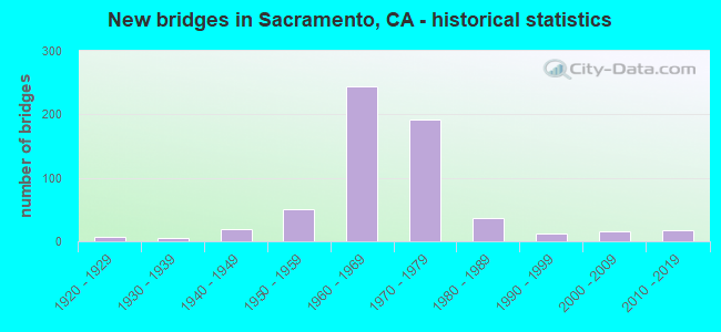
- New bridges - historical statistics
- 11910-1919
- 71920-1929
- 61930-1939
- 191940-1949
- 511950-1959
- 2451960-1969
- 1921970-1979
- 361980-1989
- 131990-1999
- 152000-2009
- 182010-2019

- Reconstructed bridges - Historical Statistics
- 11920-1929
- 01930-1939
- 01940-1949
- 41950-1959
- 151960-1969
- 41970-1979
- 71980-1989
- 81990-1999
- 122000-2009
- 22010-2019


- Bridge Condition - Deck
- 61.5%Good
- 14.3%Satisfactory
- 21.7%Fair
- 2.4%Poor

- Bridge Condition - Superstructure
- 63.4%Good
- 12.7%Satisfactory
- 22.9%Fair
- 1.0%Poor

- Bridge Condition - Substructure
- 0.3%Very good
- 83.2%Good
- 9.6%Satisfactory
- 6.8%Fair

- Bridge Condition - Channel
- 6.3%Excellent
- 53.9%Very good
- 19.5%Good
- 19.5%Satisfactory
- 0.8%Poor

- Bridge Condition - Culverts
- 66.7%Good
- 33.3%Satisfactory
Find on map >> Show street view
Structure Number: 24C0143R, Location: 0.6 MI N/O SR. 50 (Lat: 38.562136, Lng: -121.409064), Route carried "under" structure: City street , Year Built: 1969, Structure Length: 0. m, Average Daily Traffic: 3,309 (year 2009), Truck Traffic: 3%, Features Intersected: UNIVERSITY AVENUE, Facility Carried by Structure: HOWE AVE NB
Minimum Vertical Clearance: 4.72m (15.49ft), Kilometerpoint: 0.000, Lanes on structure: 2, Lanes under structure: 2, Material/Design: Concrete continuous, Design/Construction: Slab, Length of Maximum Span: 12.8m (42.0ft)
Find on map >> Show street view
Structure Number: 24C0174, Location: 0.4 MI N OF S.R. 50 (Lat: 38.563922, Lng: -121.382389), Route carried "under" structure: City street , Year Built: 1960, Structure Length: 0. m, Average Daily Traffic: 14,162 (year 2009), Truck Traffic: 5%, Features Intersected: LA RIVIERA DR, Facility Carried by Structure: WATT AVE
Minimum Vertical Clearance: 4.40m (14.44ft), Kilometerpoint: 0.000, Lanes on structure: 8, Lanes under structure: 4, Material/Design: Concrete continuous, Design/Construction: Slab, Length of Maximum Span: 15.2m (49.9ft)
Find on map >> Show street view
Structure Number: 24C0235, Location: 0.2 MI E OF 65TH ST (Lat: 38.552694, Lng: -121.423000), Route carried "under" structure: City street , Year Built: 1928, Structure Length: 0. m, Average Daily Traffic: 20,156 (year 2009), Truck Traffic: 10%, Features Intersected: FOLSOM BLVD, Facility Carried by Structure: UP RR & BNSF RY
Minimum Vertical Clearance: 4.62m (15.16ft), Kilometerpoint: 0.000, Lanes under structure: 2, Material/Design: Steel, Design/Construction: Girder and Floorbeam System, Length of Maximum Span: 17.1m (56.1ft)
Find on map >> Show street view
Structure Number: 24C03, Location: AT 24TH ST (Lat: 38.539286, Lng: -121.484781), Route carried "under" structure: City street , Year Built: 1955, Structure Length: 0. m, Average Daily Traffic: 11,375 (year 2009), Truck Traffic: 10%, Features Intersected: 24TH, LRT, UP RR, WP BY, Facility Carried by Structure: SUTTERVILLE ROAD
Minimum Vertical Clearance: 7.26m (23.82ft), Kilometerpoint: 0.000, Lanes on structure: 4, Lanes under structure: 2, Material/Design: Concrete continuous, Design/Construction: Box Beam or Girders - Multiple, Length of Maximum Span: 32.6m (107.0ft)
Find on map >> Show street view
Structure Number: 24C0371, Location: 0.15 MI E HAVENSIDE DR (Lat: 38.513825, Lng: -121.530261), Route carried "under" structure: City street , Year Built: 1981, Structure Length: 0. m, Average Daily Traffic: 17,599 (year 2008), Truck Traffic: 10%, Features Intersected: RIVERSIDE BLVD, Facility Carried by Structure: SEYMOUR PARK POC
Minimum Vertical Clearance: 4.64m (15.22ft), Kilometerpoint: 0.000, Lanes under structure: 5, Material/Design: Concrete continuous, Design/Construction: Box Beam or Girders - Single/Spread, Length of Maximum Span: 25.9m (85.0ft)
Find on map >> Show street view
Structure Number: 24C0372, Location: 0.15 MI E HAVENSIDE DR (Lat: 38.496644, Lng: -121.528789), Route carried "under" structure: City street , Year Built: 1980, Structure Length: 0. m, Average Daily Traffic: 33,783 (year 2007), Truck Traffic: 10%, Features Intersected: FLORIN ROAD, Facility Carried by Structure: PEDESTRIAN WALKWAY
Minimum Vertical Clearance: 4.82m (15.81ft), Kilometerpoint: 0.000, Lanes under structure: 4, Material/Design: Concrete continuous, Design/Construction: Box Beam or Girders - Single/Spread, Length of Maximum Span: 18.3m (60.0ft)
Find on map >> Show street view
Structure Number: 24C0373, Location: 0.15 MI E HAVENSIDE DR (Lat: 38.506503, Lng: -121.527219), Route carried "under" structure: City street , Year Built: 1963, Structure Length: 0. m, Average Daily Traffic: 4,281 (year 2007), Truck Traffic: 10%, Features Intersected: GLORIA DRIVE, Facility Carried by Structure: SEYMOUR PARK POC
Minimum Vertical Clearance: 4.39m (14.40ft), Kilometerpoint: 0.000, Lanes under structure: 2, Material/Design: Concrete continuous, Design/Construction: Tee Beam, Length of Maximum Span: 20.1m (65.9ft)
Find on map >> Show street view
Structure Number: 24C0447, Location: 625' S/O FOLSOM BLVD (Lat: 38.547628, Lng: -121.409225), Route carried "under" structure: City street , Year Built: 1999, Structure Length: 0. m, Average Daily Traffic: 18,269 (year 2008), Truck Traffic: 5%, Features Intersected: POWER INN RD, Facility Carried by Structure: SACREGIONALTRANSIT
Minimum Vertical Clearance: 5.00m (16.40ft), Kilometerpoint: 0.000, Lanes under structure: 6, Material/Design: Prestressed concrete, Design/Construction: Box Beam or Girders - Single/Spread, Length of Maximum Span: 18.3m (60.0ft)
Find on map >> Show street view
Structure Number: 24C0448, Location: 675' S/O FOLSOM BLVD (Lat: 38.547553, Lng: -121.409231), Route carried "under" structure: City street , Year Built: 1999, Structure Length: 0. m, Average Daily Traffic: 18,269 (year 2008), Truck Traffic: 5%, Features Intersected: POWER INN RD, Facility Carried by Structure: RAILROAD
Minimum Vertical Clearance: 4.90m (16.08ft), Kilometerpoint: 0.000, Lanes under structure: 6, Material/Design: Prestressed concrete continuous, Design/Construction: Box Beam or Girders - Multiple, Length of Maximum Span: 17.1m (56.1ft)
Find on map >> Show street view
Structure Number: 24C0617, Location: 0.6 MI W/O FRANKLIN BLVD (Lat: 38.495411, Lng: -121.470708), Route carried "under" structure: City street , Year Built: 2003, Structure Length: 0. m, Average Daily Traffic: 29,494 (year 2013), Truck Traffic: 5%, Features Intersected: FLORIN RD, Facility Carried by Structure: SACREGIONALTRANSIT
Minimum Vertical Clearance: 5.00m (16.40ft), Kilometerpoint: 0.000, Lanes under structure: 4, Material/Design: Prestressed concrete continuous, Design/Construction: Box Beam or Girders - Multiple, Length of Maximum Span: 29.0m (95.1ft)
Find on map >> Show street view
Structure Number: 24C0622, Location: 350' W/O BRUCEVILLE RD (Lat: 38.458119, Lng: -121.421100), Route carried "under" structure: City street , Year Built: 2014, Structure Length: 0. m, Average Daily Traffic: 22,788 (year 2011), Truck Traffic: 5%, Features Intersected: COSUMNES RIVER BLVD, Facility Carried by Structure: SACREGIONALTRANSIT
Minimum Vertical Clearance: 5.89m (19.32ft), Kilometerpoint: 0.000, Lanes under structure: 3, Material/Design: Prestressed concrete continuous, Design/Construction: Box Beam or Girders - Multiple, Length of Maximum Span: 50.4m (165.4ft)