Bridge Statistics for Plano, Texas (TX)
Condition, Traffic, Stress, Structural Evaluation, Project Costs
- National Bridge Inventory (NBI) Statistics
- 326Number of bridges
- 6,532ft / 1,991mTotal length
- $1,545,000Total costs
- 10,778,666Total average daily traffic
- 502,222Total average daily truck traffic
- National Bridge Inventory (NBI) Registered Bridges for Plano
- No street view available for this location
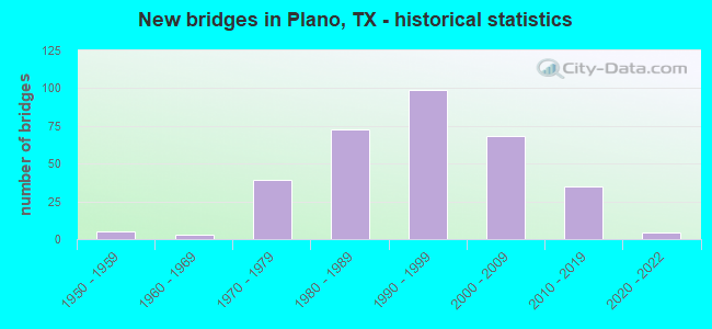
- New bridges - historical statistics
- 51950-1959
- 31960-1969
- 391970-1979
- 731980-1989
- 991990-1999
- 682000-2009
- 352010-2019
- 42020-2022

- Reconstructed bridges - Historical Statistics
- 61980-1989
- 171990-1999
- 42000-2009
- 112010-2019
- 102020-2022


- Bridge Condition - Deck
- 9.7%Very good
- 73.4%Good
- 15.6%Satisfactory
- 1.3%Fair

- Bridge Condition - Superstructure
- 36.4%Very good
- 51.9%Good
- 11.0%Satisfactory
- 0.6%Fair

- Bridge Condition - Substructure
- 0.6%Very good
- 64.9%Good
- 34.4%Satisfactory

- Bridge Condition - Channel
- 9.7%Very good
- 40.3%Good
- 44.2%Satisfactory
- 5.8%Fair

- Bridge Condition - Culverts
- 60.9%Good
- 37.3%Satisfactory
- 1.8%Fair
- 0.9%Poor
Find on map >> Show street view
Structure Number: 180430C01040005, Location: 0.65 MI N OF PARKER BLVD (Lat: 33.054375, Lng: -96.829714), Route carried "under" structure: City street , Year Built: 1991, Structure Length: 0. m, Average Daily Traffic: 13,933 (year 2015), Features Intersected: WINDHAVEN PARKWAY, Facility Carried by Structure: DALLAS N TOLLWAY
Minimum Vertical Clearance: 4.63m (15.19ft), Kilometerpoint: 1.062, Lanes on structure: 9, Lanes under structure: 12, Material/Design: Prestressed concrete, Design/Construction: Stringer/Multi-beam, Length of Maximum Span: 38.7m (127.0ft)
Find on map >> Show street view
Structure Number: 180430C01040006, Location: 1.55 MI N OF PARKER BLVD (Lat: 33.064928, Lng: -96.824661), Route carried "under" structure: City street , Year Built: 1991, Structure Length: 0. m, Average Daily Traffic: 14,252 (year 2015), Truck Traffic: 3%, Features Intersected: W SPRING CREEK PKWY, Facility Carried by Structure: DALLAS N TOLLWAY
Minimum Vertical Clearance: 4.94m (16.21ft), Kilometerpoint: 0.002, Lanes on structure: 8, Lanes under structure: 10, Material/Design: Prestressed concrete, Design/Construction: Stringer/Multi-beam, Length of Maximum Span: 34.7m (113.8ft)
Find on map >> Show street view
Structure Number: 180430C0104001, Location: 1.2 MI N OF W PARK BLVD (Lat: 33.044814, Lng: -96.829486), Route carried "under" structure: City street , Year Built: 1991, Structure Length: 0. m, Average Daily Traffic: 29,712 (year 2015), Truck Traffic: 3%, Features Intersected: W PARKER RD, Facility Carried by Structure: DALLAS N TOLLWAY
Minimum Vertical Clearance: 5.03m (16.50ft), Kilometerpoint: 1.255, Lanes on structure: 8, Lanes under structure: 12, Material/Design: Prestressed concrete, Design/Construction: Stringer/Multi-beam, Length of Maximum Span: 40.2m (131.9ft)
Find on map >> Show street view
Structure Number: 180430C01040011, Location: 1.2 MI S OF W PARKER RD (Lat: 33.027536, Lng: -96.829200), Route carried "under" structure: City street 544, Year Built: 1991, Structure Length: 0. m, Average Daily Traffic: 33,244 (year 2015), Truck Traffic: 3%, Features Intersected: W PARK BLVD, Facility Carried by Structure: DALLAS N TOLLWAY
Minimum Vertical Clearance: 4.91m (16.11ft), Kilometerpoint: 1.384, Lanes on structure: 9, Lanes under structure: 11, Material/Design: Prestressed concrete, Design/Construction: Stringer/Multi-beam, Length of Maximum Span: 40.2m (131.9ft)
Find on map >> Show street view
Structure Number: 180430C01040012, Location: 0.85 MI S OF SH 121 (Lat: 33.077822, Lng: -96.824794), Route carried "under" structure: Other road , Year Built: 1991, Structure Length: 0. m, Average Daily Traffic: 16,400 (year 2011), Truck Traffic: 10%, Features Intersected: DALLAS NORTH TOLLWAY, Facility Carried by Structure: LEGACY DR EB
Minimum Vertical Clearance: 5.28m (17.32ft), Kilometerpoint: 7.242, Lanes on structure: 5, Lanes under structure: 8, Toll: On toll road, Material/Design: Prestressed concrete, Design/Construction: Stringer/Multi-beam, Length of Maximum Span: 29.3m (96.1ft)
Find on map >> Show street view
Structure Number: 180430C01040013, Location: 0.85 MI S OF SH 121 (Lat: 33.078100, Lng: -96.824794), Route carried "under" structure: Other road , Year Built: 1991, Structure Length: 0. m, Average Daily Traffic: 16,400 (year 2011), Truck Traffic: 10%, Features Intersected: DALLAS NORTH TOLLWAY, Facility Carried by Structure: LEGACY DR WB
Minimum Vertical Clearance: 5.01m (16.44ft), Kilometerpoint: 7.258, Lanes on structure: 5, Lanes under structure: 8, Toll: On toll road, Material/Design: Prestressed concrete, Design/Construction: Stringer/Multi-beam, Length of Maximum Span: 29.3m (96.1ft)
Find on map >> Show street view
Structure Number: 180430C01040014, Location: 0.25 MI N OF PGBT (Lat: 33.016481, Lng: -96.829044), Route carried "under" structure: Other road , Year Built: 1991, Structure Length: 0. m, Average Daily Traffic: 106,835 (year 2017), Truck Traffic: 3%, Features Intersected: DALLAS NORTH TOLLWAY, Facility Carried by Structure: EB PLANO PKWY
Minimum Vertical Clearance: 5.13m (16.83ft), Kilometerpoint: 0.002, Lanes on structure: 6, Lanes under structure: 6, Toll: On toll road, Material/Design: Prestressed concrete, Design/Construction: Stringer/Multi-beam, Length of Maximum Span: 32.9m (107.9ft)
Find on map >> Show street view
Structure Number: 180430C01040018, Location: 0.5 MI S OF SH 121 (Lat: 33.084369, Lng: -96.823692), Route carried "under" structure: Other road , Year Built: 2003, Structure Length: 0. m, Average Daily Traffic: 10,000 (year 2011), Truck Traffic: 1%, Features Intersected: DALLAS NORTH TOLLWAY, Facility Carried by Structure: HEADQUARTERS (WB)
Minimum Vertical Clearance: 5.39m (17.68ft), Kilometerpoint: 0.805, Lanes on structure: 6, Lanes under structure: 9, Toll: On toll road, Material/Design: Prestressed concrete, Design/Construction: Stringer/Multi-beam, Length of Maximum Span: 29.0m (95.1ft)
Find on map >> Show street view
Structure Number: 180430C01040019, Location: 0.5 MI S OF SH 121 (Lat: 33.084014, Lng: -96.824303), Route carried "under" structure: Other road , Year Built: 2003, Structure Length: 0. m, Average Daily Traffic: 10,000 (year 2011), Truck Traffic: 1%, Features Intersected: DALLAS NORTH TOLLWAY, Facility Carried by Structure: HEADQUARTERS (EB)
Minimum Vertical Clearance: 5.39m (17.68ft), Kilometerpoint: 0.805, Lanes on structure: 6, Lanes under structure: 9, Toll: On toll road, Material/Design: Prestressed concrete, Design/Construction: Box Beam or Girders - Multiple, Length of Maximum Span: 29.0m (95.1ft)
Find on map >> Show street view
Structure Number: 180430C0104002, Location: 0.5 Mi N of PGB Turnpike (Lat: 33.020458, Lng: -96.829642), Route carried "under" structure: Ramp Other road , Year Built: 2019, Structure Length: 0. m, Average Daily Traffic: 15,191 (year 2017), Features Intersected: DNT ENTRANCE RAMP, Facility Carried by Structure: DNT Entrance Ramp
Minimum Vertical Clearance: 5.05m (16.57ft), Kilometerpoint: 0.000, Lanes on structure: 1, Lanes under structure: 2, Toll: On toll road, Material/Design: Prestressed concrete, Design/Construction: Stringer/Multi-beam, Length of Maximum Span: 33.5m (109.9ft)
Find on map >> Show street view
Structure Number: 180430C01040021, Location: 0.4 Mi N of PGB Turnpike (Lat: 33.019775, Lng: -96.828972), Route carried "under" structure: Ramp Other road , Year Built: 2019, Structure Length: 0. m, Average Daily Traffic: 26,483 (year 2017), Features Intersected: DNT NB EXIT RAMP, Facility Carried by Structure: DNT NB Exit Ramp
Minimum Vertical Clearance: 5.18m (16.99ft), Kilometerpoint: 0.000, Lanes on structure: 1, Lanes under structure: 2, Toll: On toll road, Material/Design: Prestressed concrete, Design/Construction: Stringer/Multi-beam, Length of Maximum Span: 32.9m (107.9ft)
Find on map >> Show street view
Structure Number: 180430C01040022, Location: 1.3 MI S OF SH 121 (Lat: 33.072164, Lng: -96.824706), Route carried "under" structure: Other road , Year Built: 2016, Structure Length: 0. m, Average Daily Traffic: 16,400 (year 2011), Truck Traffic: 10%, Features Intersected: DALLAS NORTH TOLLWAY, Facility Carried by Structure: TENNYSON PKWY WB
Minimum Vertical Clearance: 5.56m (18.24ft), Kilometerpoint: 6.582, Lanes on structure: 10, Toll: On toll road, Material/Design: Steel, Design/Construction: Stringer/Multi-beam, Length of Maximum Span: 49.7m (163.1ft)
Find on map >> Show street view
Structure Number: 180430C01040023, Location: 1.3 mi S of SH 121 (Lat: 33.071903, Lng: -96.824717), Route carried "under" structure: Other road , Year Built: 2020, Structure Length: 0. m, Average Daily Traffic: 16,400 (year 2018), Truck Traffic: 5%, Features Intersected: Dallas North Tollway, Facility Carried by Structure: Tennyson Pkwy EB
Minimum Vertical Clearance: 5.56m (18.24ft), Kilometerpoint: 6.582, Lanes on structure: 10, Toll: On toll road, Material/Design: Steel, Design/Construction: Stringer/Multi-beam, Length of Maximum Span: 49.7m (163.1ft)
Find on map >> Show street view
Structure Number: 180430C01040024, Location: 0.90 MI S OF SRT (Lat: 33.078261, Lng: -96.824506), Route carried "under" structure: Other road , Year Built: 2020, Structure Length: 0. m, Average Daily Traffic: 106,835 (year 2017), Truck Traffic: 3%, Features Intersected: DALLAS NORTH TOLLWAY, Facility Carried by Structure: LEGACY DR NORTH TA
Minimum Vertical Clearance: 5.03m (16.50ft), Kilometerpoint: 0.000, Lanes on structure: 1, Lanes under structure: 10, Toll: On toll road, Material/Design: Prestressed concrete, Design/Construction: Stringer/Multi-beam, Length of Maximum Span: 30.8m (101.0ft)
Find on map >> Show street view
Structure Number: 180430C01040025, Location: 0.25 MI N OF PGBT (Lat: 33.016458, Lng: -96.828869), Route carried "under" structure: Other road , Year Built: 1991, Structure Length: 0. m, Average Daily Traffic: 22,723 (year 2017), Truck Traffic: 3%, Features Intersected: DALLAS NORTH TOLLWAY, Facility Carried by Structure: WB PLANO PKWY
Minimum Vertical Clearance: 5.13m (16.83ft), Lanes on structure: 6, Lanes under structure: 6, Toll: On toll road, Material/Design: Prestressed concrete, Design/Construction: Stringer/Multi-beam, Length of Maximum Span: 32.9m (107.9ft)