Bridge Statistics for Plano, Texas (TX)
Condition, Traffic, Stress, Structural Evaluation, Project Costs
- National Bridge Inventory (NBI) Statistics
- 326Number of bridges
- 6,532ft / 1,991mTotal length
- $1,545,000Total costs
- 10,778,666Total average daily traffic
- 502,222Total average daily truck traffic
- National Bridge Inventory (NBI) Registered Bridges for Plano
- No street view available for this location
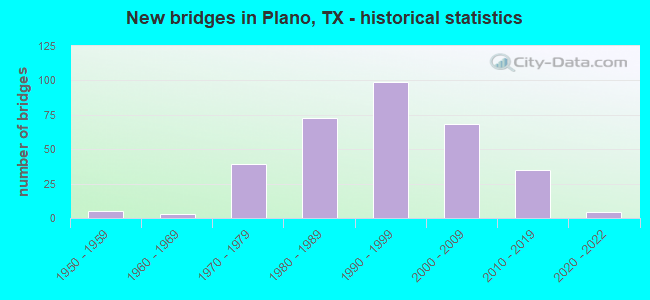
- New bridges - historical statistics
- 51950-1959
- 31960-1969
- 391970-1979
- 731980-1989
- 991990-1999
- 682000-2009
- 352010-2019
- 42020-2022

- Reconstructed bridges - Historical Statistics
- 61980-1989
- 171990-1999
- 42000-2009
- 112010-2019
- 102020-2022


- Bridge Condition - Deck
- 9.7%Very good
- 73.4%Good
- 15.6%Satisfactory
- 1.3%Fair

- Bridge Condition - Superstructure
- 36.4%Very good
- 51.9%Good
- 11.0%Satisfactory
- 0.6%Fair

- Bridge Condition - Substructure
- 0.6%Very good
- 64.9%Good
- 34.4%Satisfactory

- Bridge Condition - Channel
- 9.7%Very good
- 40.3%Good
- 44.2%Satisfactory
- 5.8%Fair

- Bridge Condition - Culverts
- 60.9%Good
- 37.3%Satisfactory
- 1.8%Fair
- 0.9%Poor
Find on map >> Show street view
Structure Number: 180430C04208001, Location: 0.30 MI W SPRING CREEK (Lat: 33.056889, Lng: -96.812472), Route carried "on" structure: City street , Year Built: 2010, Year Reconstructed: 2014, Status: Open, Structure Length: 1.59m (5.22ft), Average Daily Traffic: 8,400 (year 2011), Truck Traffic: 5%, Average Future Daily Traffic: 16,100 (year 2031), Features Intersected: DRAINAGE DITCH, Facility Carried by Structure: WINDHAVEN PKWY
Minimum Vertical Clearance: 30+ m (98+ ft), Kilometerpoint: 0.000, Lanes on structure: 4, Owner: City or Municipal Highway Agency, Approaching Roadway Width: 15.9m (52.2ft), Skew: 3 degrees, Material/Design: Concrete, Design/Construction: Culvert, Number Of Spans In Main Unit: 5, Length of Maximum Span: 3.0m (9.8ft), Curb-To-Curb Width: 17.7m (58.1ft), Out-to-Out Width: 38.3m (125.7ft)
Condition: Channel: Satisfactory, Culverts: Satisfactory, Operating Rating: 32.7 metric tons, Method Used To Determine Operating Rating: Field evaluation and documented engineering judgment, Inventory Rating: 24.5 metric tons, Method Used To Determine Inventory Rating: Field evaluation and documented engineering judgment, Structural Evaluation: Equal to present minimum criteria, Deck Geometry: Somewhat better than minimum adequacy, Waterway Adequacy: Better than present minimum criteria, Approach Roadway Alignment: Equal to present desirable criteria, Designated Inspection Frequency: Every 24 months, Inspection Date: April 2021, Deck Structure Type: Concrete Cast-file-Place, Wearing Surface/Protective System: Wearing Surface: Monolithic Concrete
Find on map >> Show street view
Structure Number: 180430C04260001, Location: 0.15 MI N OF W PARK BLVD (Lat: 33.028892, Lng: -96.762161), Route carried "on" structure: City street , Year Built: 1979, Status: Open, Structure Length: 0.94m (3.08ft), Average Daily Traffic: 1,227 (year 2019), Average Future Daily Traffic: 2,937 (year 2031), Features Intersected: PRAIRIE CREEK, Facility Carried by Structure: WOODBURN CORNERS
Minimum Vertical Clearance: 30+ m (98+ ft), Kilometerpoint: 0.322, Lanes on structure: 2, Owner: City or Municipal Highway Agency, Approaching Roadway Width: 11.0m (36.1ft), Material/Design: Concrete, Design/Construction: Culvert, Number Of Spans In Main Unit: 3, Length of Maximum Span: 3.0m (9.8ft), Curb or Sidewalk Widths: Left: 1.2m (3.9ft), Right: 1.2m (3.9ft), Curb-To-Curb Width: 11.1m (36.4ft), Out-to-Out Width: 18.3m (60.0ft)
Condition: Channel: Very good, Culverts: Good, Operating Rating: 32.7 metric tons, Method Used To Determine Operating Rating: Field evaluation and documented engineering judgment, Inventory Rating: 24.5 metric tons, Method Used To Determine Inventory Rating: Field evaluation and documented engineering judgment, Structural Evaluation: Equal to present minimum criteria, Deck Geometry: Equal to present minimum criteria, Waterway Adequacy: Better than present minimum criteria, Approach Roadway Alignment: Better than present minimum criteria, Designated Inspection Frequency: Every 24 months, Inspection Date: April 2021, Deck Structure Type: Concrete Cast-file-Place, Wearing Surface/Protective System: Wearing Surface: Monolithic Concrete
Find on map >> Show street view
Structure Number: 180430C04335002, Location: 1.90 MI E OF SHILOH RD (Lat: 33.010567, Lng: -96.631581), Route carried "on" structure: City street 544, Year Built: 1998, Status: Open, Structure Length: 5.06m (16.60ft), Average Daily Traffic: 15,125 (year 2011), Average Future Daily Traffic: 21,780 (year 2031), Features Intersected: ROWLETT CREEK
Minimum Vertical Clearance: 30+ m (98+ ft), Kilometerpoint: 20.761, Lanes on structure: 3, Owner: City or Municipal Highway Agency, Approaching Roadway Width: 12.2m (40.0ft), Skew: 1 degrees, Material/Design: Prestressed concrete, Design/Construction: Stringer/Multi-beam, Number Of Spans In Main Unit: 2, Length of Maximum Span: 25.3m (83.0ft), Curb-To-Curb Width: 12.1m (39.7ft), Out-to-Out Width: 15.9m (52.2ft)
Condition: Deck: Good, Superstructure: Good, Substructure: Good, Channel: Good, Operating Rating: 32.7 metric tons, Method Used To Determine Operating Rating: Field evaluation and documented engineering judgment, Inventory Rating: 24.5 metric tons, Method Used To Determine Inventory Rating: Field evaluation and documented engineering judgment, Structural Evaluation: Equal to present minimum criteria, Deck Geometry: Meets minimum limits, Waterway Adequacy: Equal to present minimum criteria, Approach Roadway Alignment: Equal to present desirable criteria, Designated Inspection Frequency: Every 24 months, Inspection Date: March 2021, Deck Structure Type: Concrete Precast Panels
Find on map >> Show street view
Structure Number: 180430C04335003, Location: 1.80 MI E OF SHILOH RD (Lat: 33.010153, Lng: -96.632906), Route carried "on" structure: City street 544, Year Built: 1998, Status: Open, Structure Length: 10.03m (32.91ft), Average Daily Traffic: 15,120 (year 2011), Truck Traffic: 5%, Average Future Daily Traffic: 22,000 (year 2031), Features Intersected: ROWLETT CREEK RELIEF
Minimum Vertical Clearance: 30+ m (98+ ft), Kilometerpoint: 20.439, Lanes on structure: 3, Owner: City or Municipal Highway Agency, Approaching Roadway Width: 12.2m (40.0ft), Material/Design: Prestressed concrete, Design/Construction: Stringer/Multi-beam, Number Of Spans In Main Unit: 4, Length of Maximum Span: 25.0m (82.0ft), Curb-To-Curb Width: 12.1m (39.7ft), Out-to-Out Width: 15.9m (52.2ft)
Condition: Deck: Good, Superstructure: Good, Substructure: Good, Channel: Good, Operating Rating: 32.7 metric tons, Method Used To Determine Operating Rating: Field evaluation and documented engineering judgment, Inventory Rating: 24.5 metric tons, Method Used To Determine Inventory Rating: Field evaluation and documented engineering judgment, Structural Evaluation: Equal to present minimum criteria, Deck Geometry: Meets minimum limits, Waterway Adequacy: Equal to present minimum criteria, Approach Roadway Alignment: Equal to present desirable criteria, Designated Inspection Frequency: Every 24 months, Inspection Date: March 2021, Deck Structure Type: Concrete Precast Panels
Find on map >> Show street view
Structure Number: 180430C04335004, Location: 1.90 MI E OF SHILOH RD (Lat: 33.010597, Lng: -96.631586), Route carried "on" structure: City street 544, Year Built: 1998, Status: Open, Structure Length: 5.06m (16.60ft), Average Daily Traffic: 15,125 (year 2011), Average Future Daily Traffic: 21,780 (year 2031), Features Intersected: ROWLETT CREEK
Minimum Vertical Clearance: 30+ m (98+ ft), Kilometerpoint: 20.761, Lanes on structure: 3, Owner: City or Municipal Highway Agency, Approaching Roadway Width: 12.2m (40.0ft), Skew: 1 degrees, Material/Design: Prestressed concrete, Design/Construction: Stringer/Multi-beam, Number Of Spans In Main Unit: 2, Length of Maximum Span: 25.3m (83.0ft), Curb or Sidewalk Widths: Left: 1.8m (5.9ft), Right: 0.0m, Curb-To-Curb Width: 12.1m (39.7ft), Out-to-Out Width: 15.9m (52.2ft)
Condition: Deck: Good, Superstructure: Good, Substructure: Good, Channel: Satisfactory, Operating Rating: 32.7 metric tons, Method Used To Determine Operating Rating: Field evaluation and documented engineering judgment, Inventory Rating: 24.5 metric tons, Method Used To Determine Inventory Rating: Field evaluation and documented engineering judgment, Structural Evaluation: Equal to present minimum criteria, Deck Geometry: Meets minimum limits, Waterway Adequacy: Equal to present minimum criteria, Approach Roadway Alignment: Equal to present desirable criteria, Designated Inspection Frequency: Every 24 months, Inspection Date: March 2021, Deck Structure Type: Concrete Precast Panels
Find on map >> Show street view
Structure Number: 180430C04335005, Location: 1.80 MI E OF SHILOH RD (Lat: 33.010194, Lng: -96.632919), Route carried "on" structure: City street 544, Year Built: 1998, Status: Open, Structure Length: 10.03m (32.91ft), Average Daily Traffic: 15,120 (year 2011), Truck Traffic: 5%, Average Future Daily Traffic: 22,000 (year 2031), Features Intersected: ROWLETT CREEK RELIEF
Minimum Vertical Clearance: 30+ m (98+ ft), Kilometerpoint: 20.439, Lanes on structure: 3, Owner: City or Municipal Highway Agency, Approaching Roadway Width: 12.2m (40.0ft), Material/Design: Prestressed concrete, Design/Construction: Stringer/Multi-beam, Number Of Spans In Main Unit: 4, Length of Maximum Span: 25.0m (82.0ft), Curb or Sidewalk Widths: Left: 1.8m (5.9ft), Right: 0.0m, Curb-To-Curb Width: 12.1m (39.7ft), Out-to-Out Width: 15.9m (52.2ft)
Condition: Deck: Good, Superstructure: Good, Substructure: Good, Channel: Good, Operating Rating: 32.7 metric tons, Method Used To Determine Operating Rating: Field evaluation and documented engineering judgment, Inventory Rating: 24.5 metric tons, Method Used To Determine Inventory Rating: Field evaluation and documented engineering judgment, Structural Evaluation: Equal to present minimum criteria, Deck Geometry: Meets minimum limits, Waterway Adequacy: Equal to present minimum criteria, Approach Roadway Alignment: Equal to present desirable criteria, Designated Inspection Frequency: Every 24 months, Inspection Date: March 2021, Deck Structure Type: Concrete Precast Panels
Find on map >> Show street view
Structure Number: 180430C04350003, Location: 0.20 MI W OF INDEPENDENCE (Lat: 33.019408, Lng: -96.752872), Route carried "on" structure: City street 26, Year Built: 1982, Status: Open, Structure Length: 1.95m (6.40ft), Average Daily Traffic: 19,400 (year 2011), Average Future Daily Traffic: 27,936 (year 2031), Features Intersected: PRAIRIE CREEK, Facility Carried by Structure: W 15TH ST
Minimum Vertical Clearance: 30+ m (98+ ft), Kilometerpoint: 9.012, Lanes on structure: 6, Owner: City or Municipal Highway Agency, Approaching Roadway Width: 20.1m (65.9ft), Skew: 29 degrees, Material/Design: Concrete, Design/Construction: Culvert, Number Of Spans In Main Unit: 6, Length of Maximum Span: 3.0m (9.8ft), Curb or Sidewalk Widths: Left: 1.8m (5.9ft), Right: 0.0m
Condition: Channel: Good, Culverts: Satisfactory, Operating Rating: 32.7 metric tons, Method Used To Determine Operating Rating: Field evaluation and documented engineering judgment, Inventory Rating: 24.5 metric tons, Method Used To Determine Inventory Rating: Field evaluation and documented engineering judgment, Structural Evaluation: Equal to present minimum criteria, Waterway Adequacy: Equal to present minimum criteria, Approach Roadway Alignment: Equal to present desirable criteria, Designated Inspection Frequency: Every 24 months, Inspection Date: March 2021
Find on map >> Show street view
Structure Number: 180430C04350004, Location: 0.20 MI E OF CUSTER RD (Lat: 33.019442, Lng: -96.730025), Route carried "on" structure: City street 26, Year Built: 1980, Status: Open, Structure Length: 1.83m (6.00ft), Average Daily Traffic: 20,210 (year 2019), Truck Traffic: 4%, Average Future Daily Traffic: 38,304 (year 2031), Features Intersected: PITTMAN CREEK, Facility Carried by Structure: W 15TH ST
Minimum Vertical Clearance: 30+ m (98+ ft), Kilometerpoint: 11.104, Lanes on structure: 6, Owner: City or Municipal Highway Agency, Approaching Roadway Width: 20.4m (66.9ft), Skew: 30 degrees, Material/Design: Prestressed concrete, Design/Construction: Stringer/Multi-beam, Number Of Spans In Main Unit: 1, Length of Maximum Span: 18.3m (60.0ft), Curb or Sidewalk Widths: Left: 1.7m (5.6ft), Right: 1.7m (5.6ft), Curb-To-Curb Width: 20.4m (66.9ft), Out-to-Out Width: 28.7m (94.2ft)
Condition: Deck: Good, Superstructure: Very good, Substructure: Satisfactory, Channel: Satisfactory, Operating Rating: 32.7 metric tons, Method Used To Determine Operating Rating: Field evaluation and documented engineering judgment, Inventory Rating: 24.5 metric tons, Method Used To Determine Inventory Rating: Field evaluation and documented engineering judgment, Structural Evaluation: Equal to present minimum criteria, Deck Geometry: High priority of replacement, Waterway Adequacy: Equal to present minimum criteria, Approach Roadway Alignment: Equal to present desirable criteria, Length Of Structure Improvement: 1.83m (6.00ft), Designated Inspection Frequency: Every 24 months, Inspection Date: March 2021, Bridge Improvement Cost: $8,000, Roadway Improvement Cost: $2,000, Total Project Cost: $10,000, Deck Structure Type: Concrete Cast-file-Place
Find on map >> Show street view
Structure Number: 180430C04350005, Location: 0.10 MI W OF US 75 (Lat: 33.019294, Lng: -96.711939), Route carried "on" structure: City street , Year Built: 1980, Status: Open, Structure Length: 4.63m (15.19ft), Average Daily Traffic: 20,699 (year 2018), Truck Traffic: 5%, Average Future Daily Traffic: 17,568 (year 2031), Design Load: H 20, Features Intersected: SPRING CREEK, Facility Carried by Structure: W 15TH ST EB
Minimum Vertical Clearance: 30+ m (98+ ft), Kilometerpoint: 12.875, Lanes on structure: 3, Owner: City or Municipal Highway Agency, Approaching Roadway Width: 10.1m (33.1ft), Material/Design: Concrete, Design/Construction: Stringer/Multi-beam, Number Of Spans In Main Unit: 5, Length of Maximum Span: 9.1m (29.9ft), Curb or Sidewalk Widths: Left: 2.2m (7.2ft), Right: 1.8m (5.9ft), Curb-To-Curb Width: 10.1m (33.1ft), Out-to-Out Width: 14.4m (47.2ft)
Condition: Deck: Satisfactory, Superstructure: Good, Substructure: Good, Channel: Satisfactory, Operating Rating: 62.6 metric tons, Method Used To Determine Operating Rating: Load Factor (LF), Inventory Rating: 38.1 metric tons, Method Used To Determine Inventory Rating: Load Factor (LF), Structural Evaluation: Better than present minimum criteria, Deck Geometry: High priority of replacement, Waterway Adequacy: Equal to present minimum criteria, Approach Roadway Alignment: Equal to present desirable criteria, Length Of Structure Improvement: 4.63m (15.19ft), Designated Inspection Frequency: Every 24 months, Inspection Date: March 2021, Bridge Improvement Cost: $10,000, Roadway Improvement Cost: $3,000, Total Project Cost: $13,000, Deck Structure Type: Concrete Cast-file-Place
Find on map >> Show street view
Structure Number: 180430C04350006, Location: 0.10 MI W OF US 75 (Lat: 33.019328, Lng: -96.711958), Route carried "on" structure: City street , Year Built: 1980, Status: Open, Structure Length: 4.63m (15.19ft), Average Daily Traffic: 20,699 (year 2018), Truck Traffic: 5%, Average Future Daily Traffic: 17,568 (year 2031), Design Load: H 20, Features Intersected: SPRING CREEK, Facility Carried by Structure: W 15TH ST WB
Minimum Vertical Clearance: 30+ m (98+ ft), Kilometerpoint: 12.875, Lanes on structure: 3, Owner: City or Municipal Highway Agency, Approaching Roadway Width: 10.1m (33.1ft), Material/Design: Concrete, Design/Construction: Stringer/Multi-beam, Number Of Spans In Main Unit: 5, Length of Maximum Span: 9.1m (29.9ft), Curb or Sidewalk Widths: Left: 1.8m (5.9ft), Right: 2.2m (7.2ft), Curb-To-Curb Width: 10.1m (33.1ft), Out-to-Out Width: 14.4m (47.2ft)
Condition: Deck: Satisfactory, Superstructure: Satisfactory, Substructure: Satisfactory, Channel: Satisfactory, Operating Rating: 62.6 metric tons, Method Used To Determine Operating Rating: Load Factor (LF), Inventory Rating: 38.1 metric tons, Method Used To Determine Inventory Rating: Load Factor (LF), Structural Evaluation: Equal to present minimum criteria, Deck Geometry: High priority of replacement, Waterway Adequacy: Equal to present minimum criteria, Approach Roadway Alignment: Equal to present desirable criteria, Length Of Structure Improvement: 4.63m (15.19ft), Designated Inspection Frequency: Every 24 months, Inspection Date: March 2021, Bridge Improvement Cost: $10,000, Roadway Improvement Cost: $3,000, Total Project Cost: $13,000, Deck Structure Type: Concrete Cast-file-Place
Find on map >> Show street view
Structure Number: 180430C04365001, Location: 0.15 MI W OF US 75 (Lat: 33.021439, Lng: -96.712436), Route carried "on" structure: City street , Year Built: 1966, Status: Posted for load, Structure Length: 3.44m (11.29ft), Average Daily Traffic: 1,772 (year 2019), Average Future Daily Traffic: 1,500 (year 2031), Design Load: HS 20, Features Intersected: SPRING CREEK, Facility Carried by Structure: W 16TH ST
Minimum Vertical Clearance: 30+ m (98+ ft), Kilometerpoint: 0.322, Lanes on structure: 2, Owner: City or Municipal Highway Agency, Approaching Roadway Width: 7.3m (24.0ft), Skew: 1 degrees, Material/Design: Concrete, Design/Construction: Stringer/Multi-beam, Number Of Spans In Main Unit: 2, Number Of Approach Spans: 1, Length of Maximum Span: 12.5m (41.0ft), Curb or Sidewalk Widths: Left: 1.1m (3.6ft), Right: 1.7m (5.6ft), Curb-To-Curb Width: 7.0m (23.0ft), Out-to-Out Width: 10.0m (32.8ft)
Condition: Deck: Fair, Superstructure: Fair, Substructure: Satisfactory, Channel: Good, Operating Rating: 32.7 metric tons, Method Used To Determine Operating Rating: Field evaluation and documented engineering judgment, Inventory Rating: 24.5 metric tons, Method Used To Determine Inventory Rating: Field evaluation and documented engineering judgment, Structural Evaluation: Somewhat better than minimum adequacy, Deck Geometry: High priority of corrective action, Waterway Adequacy: Better than present minimum criteria, Approach Roadway Alignment: Equal to present desirable criteria, Bridge Posting: Required (Relationship of Operating Rating to Maximum Legal Load: 30.0 - 39.9% below), Length Of Structure Improvement: 3.44m (11.29ft), Designated Inspection Frequency: Every 24 months, Inspection Date: April 2021, Bridge Improvement Cost: $5,000, Roadway Improvement Cost: $1,000, Total Project Cost: $6,000, Deck Structure Type: Concrete Cast-file-Place
Find on map >> Show street view
Structure Number: 180430C04425001, Location: 0.15 MI N OF E PLANO PKWY (Lat: 33.009756, Lng: -96.703022), Route carried "on" structure: City street , Year Built: 1983, Status: Open, Structure Length: 0.64m (2.10ft), Average Daily Traffic: 2,174 (year 2019), Average Future Daily Traffic: 3,200 (year 2031), Features Intersected: SPRING CREEK TRIBUTARY, Facility Carried by Structure: AVENUE F
Minimum Vertical Clearance: 30+ m (98+ ft), Kilometerpoint: 1.287, Lanes on structure: 2, Owner: City or Municipal Highway Agency, Approaching Roadway Width: 12.2m (40.0ft), Material/Design: Concrete, Design/Construction: Culvert, Number Of Spans In Main Unit: 3, Length of Maximum Span: 2.1m (6.9ft), Curb or Sidewalk Widths: Left: 0.0m, Right: 1.2m (3.9ft)
Condition: Channel: Good, Culverts: Good, Operating Rating: 32.7 metric tons, Method Used To Determine Operating Rating: Field evaluation and documented engineering judgment, Inventory Rating: 24.5 metric tons, Method Used To Determine Inventory Rating: Field evaluation and documented engineering judgment, Structural Evaluation: Equal to present minimum criteria, Waterway Adequacy: Equal to present minimum criteria, Approach Roadway Alignment: Equal to present desirable criteria, Designated Inspection Frequency: Every 24 months, Inspection Date: May 2021
Find on map >> Show street view
Structure Number: 180430F00103001, Location: 1.0 MI E OF JUPITER RD (Lat: 33.073139, Lng: -96.655275), Route carried "on" structure: City street , Year Built: 2010, Status: Open, Structure Length: 9.81m (32.19ft), Average Daily Traffic: 3,264 (year 2018), Truck Traffic: 3%, Average Future Daily Traffic: 4,570 (year 2038), Features Intersected: COTTONWOOD CREEK, Facility Carried by Structure: CHAPARRAL RD
Minimum Vertical Clearance: 30+ m (98+ ft), Kilometerpoint: 1.609, Lanes on structure: 2, Owner: City or Municipal Highway Agency, Approaching Roadway Width: 7.3m (24.0ft), Material/Design: Prestressed concrete, Design/Construction: Stringer/Multi-beam, Number Of Spans In Main Unit: 3, Length of Maximum Span: 36.6m (120.1ft), Curb or Sidewalk Widths: Left: 1.9m (6.2ft), Right: 0.0m, Curb-To-Curb Width: 8.4m (27.6ft), Out-to-Out Width: 11.6m (38.1ft)
Condition: Deck: Good, Superstructure: Very good, Substructure: Good, Channel: Satisfactory, Operating Rating: 32.7 metric tons, Method Used To Determine Operating Rating: Field evaluation and documented engineering judgment, Inventory Rating: 24.5 metric tons, Method Used To Determine Inventory Rating: Field evaluation and documented engineering judgment, Structural Evaluation: Equal to present minimum criteria, Deck Geometry: High priority of corrective action, Waterway Adequacy: Equal to present minimum criteria, Approach Roadway Alignment: Equal to present desirable criteria, Designated Inspection Frequency: Every 24 months, Inspection Date: August 2020, Deck Structure Type: Concrete Cast-file-Place
Find on map >> Show street view
Structure Number: 180430LS8401001, Location: 0.07 MI W OF W PLANO PKWY (Lat: 33.012983, Lng: -96.773653), Route carried "on" structure: City street , Year Built: 1991, Status: Open, Structure Length: 1.07m (3.51ft), Average Daily Traffic: 216 (year 2018), Truck Traffic: 3%, Average Future Daily Traffic: 302 (year 2038), Design Load: HS 20, Features Intersected: MCKAMY BRANCH, Facility Carried by Structure: COMMERCE DR
Minimum Vertical Clearance: 30+ m (98+ ft), Kilometerpoint: 0.113, Lanes on structure: 2, Owner: City or Municipal Highway Agency, Approaching Roadway Width: 11.0m (36.1ft), Material/Design: Concrete, Design/Construction: Culvert, Number Of Spans In Main Unit: 4, Length of Maximum Span: 2.4m (7.9ft), Curb or Sidewalk Widths: Left: 1.2m (3.9ft), Right: 0.0m
Condition: Channel: Very good, Culverts: Good, Operating Rating: 39.9 metric tons, Method Used To Determine Operating Rating: Load Factor (LF), Inventory Rating: 23.6 metric tons, Method Used To Determine Inventory Rating: Load Factor (LF), Structural Evaluation: Equal to present minimum criteria, Waterway Adequacy: Better than present minimum criteria, Approach Roadway Alignment: Equal to present desirable criteria, Designated Inspection Frequency: Every 24 months, Inspection Date: August 2020
Find on map >> Show street view
Structure Number: 180430LS8618001, Location: 0.20 MI N OF E PARK BLVD (Lat: 33.034950, Lng: -96.697425), Route carried "on" structure: City street , Year Built: 1978, Year Reconstructed: 1990, Status: Open, Structure Length: 1.28m (4.20ft), Average Daily Traffic: 163 (year 2019), Truck Traffic: 3%, Average Future Daily Traffic: 163 (year 2039), Features Intersected: TRIB BROWN BRANCH, Facility Carried by Structure: DOBIE DR
Minimum Vertical Clearance: 30+ m (98+ ft), Kilometerpoint: 0.322, Lanes on structure: 2, Owner: City or Municipal Highway Agency, Approaching Roadway Width: 11.0m (36.1ft), Skew: 1 degrees, Material/Design: Concrete, Design/Construction: Culvert, Number Of Spans In Main Unit: 5, Length of Maximum Span: 2.4m (7.9ft), Curb or Sidewalk Widths: Left: 1.5m (4.9ft), Right: 1.5m (4.9ft), Curb-To-Curb Width: 11.0m (36.1ft), Out-to-Out Width: 18.3m (60.0ft)
Condition: Channel: Good, Culverts: Good, Operating Rating: 32.7 metric tons, Method Used To Determine Operating Rating: Field evaluation and documented engineering judgment, Inventory Rating: 24.5 metric tons, Method Used To Determine Inventory Rating: Field evaluation and documented engineering judgment, Structural Evaluation: Equal to present minimum criteria, Deck Geometry: Equal to present desirable criteria, Waterway Adequacy: Better than present minimum criteria, Approach Roadway Alignment: Equal to present desirable criteria, Designated Inspection Frequency: Every 24 months, Inspection Date: October 2020, Deck Structure Type: Concrete Cast-file-Place, Wearing Surface/Protective System: Wearing Surface: Monolithic Concrete
Find on map >> Show street view
Structure Number: 180610C00044001, Location: 0.2 MI S OF W PARKER RD (Lat: 33.043400, Lng: -96.849361), Route carried "on" structure: City street , Year Built: 1998, Status: Open, Structure Length: 1.68m (5.51ft), Average Daily Traffic: 280 (year 2018), Average Future Daily Traffic: 420 (year 2038), Features Intersected: Indian Creek, Facility Carried by Structure: Crooked Stick Dr
Minimum Vertical Clearance: 30+ m (98+ ft), Kilometerpoint: 0.322, Lanes on structure: 2, Owner: City or Municipal Highway Agency, Approaching Roadway Width: 11.0m (36.1ft), Material/Design: Concrete, Design/Construction: Culvert, Number Of Spans In Main Unit: 5, Length of Maximum Span: 3.0m (9.8ft), Curb or Sidewalk Widths: Left: 1.2m (3.9ft), Right: 3.0m (9.8ft), Curb-To-Curb Width: 11.0m (36.1ft), Out-to-Out Width: 18.2m (59.7ft)
Condition: Channel: Satisfactory, Culverts: Good, Operating Rating: 32.7 metric tons, Method Used To Determine Operating Rating: Field evaluation and documented engineering judgment, Inventory Rating: 24.5 metric tons, Method Used To Determine Inventory Rating: Field evaluation and documented engineering judgment, Structural Evaluation: Equal to present minimum criteria, Deck Geometry: Equal to present desirable criteria, Waterway Adequacy: Better than present minimum criteria, Approach Roadway Alignment: Equal to present desirable criteria, Designated Inspection Frequency: Every 24 months, Inspection Date: August 2020, Deck Structure Type: Concrete Cast-file-Place, Wearing Surface/Protective System: Wearing Surface: Monolithic Concrete
Find on map >> Show street view
Structure Number: 180610C00833001, Location: 0.10 MI E OF LA COSTA DR (Lat: 33.039983, Lng: -96.847483), Route carried "on" structure: City street , Year Built: 1986, Status: Open, Structure Length: 0.76m (2.49ft), Average Daily Traffic: 3,760 (year 2011), Average Future Daily Traffic: 7,099 (year 2031), Features Intersected: INDIAN CREEK TRIBUTARY, Facility Carried by Structure: COLUMBINE DR
Minimum Vertical Clearance: 30+ m (98+ ft), Kilometerpoint: 0.161, Lanes on structure: 2, Owner: City or Municipal Highway Agency, Approaching Roadway Width: 13.4m (44.0ft), Skew: 20 degrees, Material/Design: Concrete, Design/Construction: Culvert, Number Of Spans In Main Unit: 2, Length of Maximum Span: 3.0m (9.8ft), Curb or Sidewalk Widths: Left: 1.2m (3.9ft), Right: 1.2m (3.9ft)
Condition: Channel: Very good, Culverts: Satisfactory, Operating Rating: 32.7 metric tons, Method Used To Determine Operating Rating: Field evaluation and documented engineering judgment, Inventory Rating: 24.5 metric tons, Method Used To Determine Inventory Rating: Field evaluation and documented engineering judgment, Structural Evaluation: Equal to present minimum criteria, Waterway Adequacy: Better than present minimum criteria, Approach Roadway Alignment: Equal to present desirable criteria, Designated Inspection Frequency: Every 24 months, Inspection Date: Febuary 2021
Find on map >> Show street view
Structure Number: 180610C02795024, Location: 1.35 MI E OF PLANO PKWY (Lat: 33.044739, Lng: -96.851228), Route carried "on" structure: City street , Year Built: 2000, Year Reconstructed: 2002, Status: Open, Structure Length: 2.13m (6.99ft), Average Daily Traffic: 600 (year 2011), Average Future Daily Traffic: 800 (year 2031), Features Intersected: INDIAN CREEK, Facility Carried by Structure: W PARKER RD
Minimum Vertical Clearance: 30+ m (98+ ft), Kilometerpoint: 0.885, Lanes on structure: 6, Owner: City or Municipal Highway Agency, Approaching Roadway Width: 20.1m (65.9ft), Skew: 20 degrees, Material/Design: Prestressed concrete, Design/Construction: Stringer/Multi-beam, Number Of Spans In Main Unit: 1, Length of Maximum Span: 21.3m (69.9ft), Curb or Sidewalk Widths: Left: 1.9m (6.2ft), Right: 1.9m (6.2ft), Curb-To-Curb Width: 20.1m (65.9ft), Out-to-Out Width: 32.0m (105.0ft)
Condition: Deck: Very good, Superstructure: Very good, Substructure: Good, Channel: Satisfactory, Operating Rating: 32.7 metric tons, Method Used To Determine Operating Rating: Field evaluation and documented engineering judgment, Inventory Rating: 24.5 metric tons, Method Used To Determine Inventory Rating: Field evaluation and documented engineering judgment, Structural Evaluation: Equal to present minimum criteria, Deck Geometry: High priority of replacement, Waterway Adequacy: Equal to present minimum criteria, Approach Roadway Alignment: Equal to present desirable criteria, Designated Inspection Frequency: Every 24 months, Inspection Date: Febuary 2021, Deck Structure Type: Concrete Cast-file-Place
Find on map >> Show street view
Structure Number: 180610C03560008, Location: 0.70 MI W OF MIDWAY ROAD (Lat: 33.069989, Lng: -96.849183), Route carried "on" structure: City street , Year Built: 2004, Status: Open, Structure Length: 3.81m (12.50ft), Average Daily Traffic: 7,464 (year 2011), Truck Traffic: 10%, Average Future Daily Traffic: 10,748 (year 2031), Design Load: HS 20, Features Intersected: INDIAN CREEK, Facility Carried by Structure: SPRING CK PKWY NB
Minimum Vertical Clearance: 30+ m (98+ ft), Kilometerpoint: 0.000, Lanes on structure: 3, Owner: City or Municipal Highway Agency, Approaching Roadway Width: 11.0m (36.1ft), Skew: 1 degrees, Material/Design: Prestressed concrete, Design/Construction: Stringer/Multi-beam, Number Of Spans In Main Unit: 1, Length of Maximum Span: 38.1m (125.0ft), Curb or Sidewalk Widths: Left: 3.0m (9.8ft), Right: 0.0m, Curb-To-Curb Width: 11.0m (36.1ft), Out-to-Out Width: 14.9m (48.9ft)
Condition: Deck: Very good, Superstructure: Good, Substructure: Good, Channel: Good, Operating Rating: 54.4 metric tons, Method Used To Determine Operating Rating: Assigned rating based on Load Factor Design (LFD) reported in metric tons, Inventory Rating: 32.7 metric tons, Method Used To Determine Inventory Rating: Assigned rating based on Load Factor Design (LFD) reported in metric tons, Structural Evaluation: Better than present minimum criteria, Deck Geometry: High priority of replacement, Waterway Adequacy: Superior to present desirable criteria, Approach Roadway Alignment: Equal to present desirable criteria, Length Of Structure Improvement: 3.81m (12.50ft), Designated Inspection Frequency: Every 24 months, Inspection Date: Febuary 2021, Bridge Improvement Cost: $9,000, Roadway Improvement Cost: $2,000, Total Project Cost: $11,000, Deck Structure Type: Concrete Cast-file-Place
Find on map >> Show street view
Structure Number: 180610C03560009, Location: 0.70 MI W OF MIDWAY ROAD (Lat: 33.069961, Lng: -96.849614), Route carried "on" structure: City street , Year Built: 2004, Status: Open, Structure Length: 3.47m (11.38ft), Average Daily Traffic: 7,464 (year 2011), Truck Traffic: 10%, Average Future Daily Traffic: 10,748 (year 2031), Design Load: HS 20, Features Intersected: INDIAN CREEK, Facility Carried by Structure: SPRING CK PKWY SB
Minimum Vertical Clearance: 30+ m (98+ ft), Kilometerpoint: 0.000, Lanes on structure: 3, Owner: City or Municipal Highway Agency, Approaching Roadway Width: 11.0m (36.1ft), Skew: 1 degrees, Material/Design: Prestressed concrete, Design/Construction: Stringer/Multi-beam, Number Of Spans In Main Unit: 1, Length of Maximum Span: 34.7m (113.8ft), Curb or Sidewalk Widths: Left: 0.0m, Right: 3.0m (9.8ft), Curb-To-Curb Width: 11.0m (36.1ft), Out-to-Out Width: 14.9m (48.9ft)
Condition: Deck: Very good, Superstructure: Satisfactory, Substructure: Good, Channel: Good, Operating Rating: 54.4 metric tons, Method Used To Determine Operating Rating: Assigned rating based on Load Factor Design (LFD) reported in metric tons, Inventory Rating: 32.7 metric tons, Method Used To Determine Inventory Rating: Assigned rating based on Load Factor Design (LFD) reported in metric tons, Structural Evaluation: Equal to present minimum criteria, Deck Geometry: High priority of replacement, Waterway Adequacy: Superior to present desirable criteria, Approach Roadway Alignment: Equal to present desirable criteria, Length Of Structure Improvement: 3.47m (11.38ft), Designated Inspection Frequency: Every 24 months, Inspection Date: Febuary 2021, Bridge Improvement Cost: $8,000, Roadway Improvement Cost: $2,000, Total Project Cost: $10,000, Deck Structure Type: Concrete Cast-file-Place
Find on map >> Show street view
Structure Number: 18043000470624, Location: 0.60 MI N OF 15TH ST (Lat: 33.028442, Lng: -96.709247), Route carried "under" structure: US 75, Year Built: 1981, Structure Length: 0. m, Average Daily Traffic: 208,921 (year 2018), Truck Traffic: 6%, Features Intersected: US 75, Facility Carried by Structure: PARK BLVD
Minimum Vertical Clearance: 6.10m (20.01ft), Kilometerpoint: 18.694, Lanes on structure: 6, Lanes under structure: 18, Material/Design: Prestressed concrete, Design/Construction: Stringer/Multi-beam, Length of Maximum Span: 24.4m (80.1ft)
Find on map >> Show street view
Structure Number: 180430004706276, Location: 1.10 MI N OF G BUSH TPKE (Lat: 33.019728, Lng: -96.709769), Route carried "under" structure: City street , Year Built: 1989, Structure Length: 0. m, Average Daily Traffic: 20,699 (year 2018), Truck Traffic: 1%, Features Intersected: E 15TH STREET, Facility Carried by Structure: US 75 NB
Minimum Vertical Clearance: 5.49m (18.01ft), Kilometerpoint: 0.805, Lanes on structure: 6, Lanes under structure: 7, Material/Design: Prestressed concrete, Design/Construction: Stringer/Multi-beam, Length of Maximum Span: 33.8m (110.9ft)
Find on map >> Show street view
Structure Number: 180430004706277, Location: US 75 & SPRING CRK PKWY (Lat: 33.057181, Lng: -96.694158), Route carried "under" structure: City street , Year Built: 1989, Structure Length: 0. m, Average Daily Traffic: 36,500 (year 2018), Truck Traffic: 4%, Features Intersected: SPRING CREEK PKWY, Facility Carried by Structure: US 75 NB
Minimum Vertical Clearance: 5.18m (16.99ft), Kilometerpoint: 0.805, Lanes on structure: 5, Lanes under structure: 8, Material/Design: Prestressed concrete, Design/Construction: Stringer/Multi-beam, Length of Maximum Span: 37.2m (122.0ft)
Find on map >> Show street view
Structure Number: 180430004706297, Location: 2.55 MI S OF FM 2170 (Lat: 33.066097, Lng: -96.690289), Route carried "under" structure: US 75, Year Built: 1992, Structure Length: 0. m, Average Daily Traffic: 161,133 (year 2013), Truck Traffic: 6%, Features Intersected: US 75, Facility Carried by Structure: LEGACY DRIVE
Minimum Vertical Clearance: 5.69m (18.67ft), Kilometerpoint: 14.074, Lanes on structure: 7, Lanes under structure: 13, Material/Design: Prestressed concrete, Design/Construction: Stringer/Multi-beam, Length of Maximum Span: 25.9m (85.0ft)
Find on map >> Show street view
Structure Number: 180430004706427, Location: 1.10 MI N OF G BUSH TNPKE (Lat: 33.019733, Lng: -96.709575), Route carried "under" structure: City street , Year Built: 1989, Structure Length: 0. m, Average Daily Traffic: 20,699 (year 2018), Truck Traffic: 2%, Features Intersected: E 15TH STREET, Facility Carried by Structure: US 75 SB
Minimum Vertical Clearance: 6.48m (21.26ft), Kilometerpoint: 0.805, Lanes on structure: 5, Lanes under structure: 7, Material/Design: Prestressed concrete, Design/Construction: Stringer/Multi-beam, Length of Maximum Span: 33.8m (110.9ft)
Find on map >> Show street view
Structure Number: 180430004706428, Location: AT US 75-SPRING CRK PKWAY (Lat: 33.057161, Lng: -96.694339), Route carried "under" structure: City street , Year Built: 1989, Structure Length: 0. m, Average Daily Traffic: 36,500 (year 2018), Truck Traffic: 4%, Features Intersected: SPRING CREEK PKWY, Facility Carried by Structure: US 75 SB
Minimum Vertical Clearance: 5.49m (18.01ft), Kilometerpoint: 0.805, Lanes on structure: 5, Lanes under structure: 8, Material/Design: Prestressed concrete, Design/Construction: Stringer/Multi-beam, Length of Maximum Span: 37.2m (122.0ft)
Find on map >> Show street view
Structure Number: 180430004706609, Location: 1.25 MI N OF 15TH ST (Lat: 33.037475, Lng: -96.704500), Route carried "under" structure: US 75, Year Built: 2010, Structure Length: 0. m, Average Daily Traffic: 185,572 (year 2010), Truck Traffic: 6%, Features Intersected: US 75, Facility Carried by Structure: PARKER RD-CENTER
Minimum Vertical Clearance: 6.20m (20.34ft), Kilometerpoint: 17.611, Lanes on structure: 8, Lanes under structure: 14, Material/Design: Prestressed concrete, Design/Construction: Stringer/Multi-beam, Length of Maximum Span: 25.0m (82.0ft)
Find on map >> Show street view
Structure Number: 18043000470661, Location: 1.25 MI N OF 15TH ST. (Lat: 33.037611, Lng: -96.704428), Route carried "under" structure: US 75, Year Built: 2010, Structure Length: 0. m, Average Daily Traffic: 185,572 (year 2018), Truck Traffic: 6%, Features Intersected: US 75, Facility Carried by Structure: PARKER RD (NORTH)
Minimum Vertical Clearance: 5.49m (18.01ft), Kilometerpoint: 17.611, Lanes on structure: 1, Lanes under structure: 10, Material/Design: Prestressed concrete, Design/Construction: Stringer/Multi-beam, Length of Maximum Span: 24.7m (81.0ft)
Find on map >> Show street view
Structure Number: 180430004706611, Location: 1.25 MI N OF 15TH ST (Lat: 33.037253, Lng: -96.704614), Route carried "under" structure: US 75, Year Built: 2010, Structure Length: 0. m, Average Daily Traffic: 208,921 (year 2018), Truck Traffic: 6%, Features Intersected: US 75, Facility Carried by Structure: PARKER RD (SOUTH)
Minimum Vertical Clearance: 5.64m (18.50ft), Kilometerpoint: 17.611, Lanes on structure: 1, Lanes under structure: 10, Material/Design: Prestressed concrete, Design/Construction: Stringer/Multi-beam, Length of Maximum Span: 24.7m (81.0ft)
Find on map >> Show street view
Structure Number: 180430004706662, Location: 0.3 mi N of PGBT (Lat: 33.009089, Lng: -97.707939), Route carried "under" structure: US 75, Year Built: 2019, Structure Length: 0. m, Average Daily Traffic: 208,921 (year 2018), Truck Traffic: 5%, Features Intersected: US 75, Facility Carried by Structure: Plano Pkwy. EB
Minimum Vertical Clearance: 5.03m (16.50ft), Lanes on structure: 5, Lanes under structure: 15, Material/Design: Prestressed concrete, Design/Construction: Stringer/Multi-beam, Length of Maximum Span: 27.0m (88.6ft)
Find on map >> Show street view
Structure Number: 180430004706663, Location: 0.3 mi N of PGBT (Lat: 33.009181, Lng: -96.707950), Route carried "under" structure: US 75, Year Built: 2019, Structure Length: 0. m, Average Daily Traffic: 239,000 (year 2018), Truck Traffic: 5%, Features Intersected: US 75, Facility Carried by Structure: Plano Pkwy. WB
Minimum Vertical Clearance: 5.08m (16.67ft), Lanes on structure: 5, Lanes under structure: 15, Material/Design: Prestressed concrete, Design/Construction: Stringer/Multi-beam, Length of Maximum Span: 27.0m (88.6ft)
Find on map >> Show street view
Structure Number: 180430036404122, Location: DNT/SH 121 INTERCHANGE (Lat: 33.091222, Lng: -96.822914), Route carried "under" structure: Other road , Year Built: 2009, Structure Length: 0. m, Average Daily Traffic: 18,919 (year 2018), Truck Traffic: 3%, Features Intersected: DNT FRONTAGE ROADS, Facility Carried by Structure: SH 121 NB
Minimum Vertical Clearance: 5.28m (17.32ft), Kilometerpoint: 12.588, Lanes on structure: 4, Lanes under structure: 6, Toll: On toll road, Material/Design: Prestressed concrete, Design/Construction: Stringer/Multi-beam, Length of Maximum Span: 36.0m (118.1ft)
Find on map >> Show street view
Structure Number: 180430036404137, Location: 5.5 MI W OF US 75 (Lat: 33.124964, Lng: -96.733219), Route carried "under" structure: State highway 2478, Year Built: 2005, Structure Length: 0. m, Average Daily Traffic: 27,884 (year 2020), Truck Traffic: 3%, Features Intersected: CUSTER RD (FM 2478), Facility Carried by Structure: SH 121 NB
Minimum Vertical Clearance: 6.40m (21.00ft), Kilometerpoint: 3.455, Lanes on structure: 4, Lanes under structure: 10, Material/Design: Prestressed concrete, Design/Construction: Stringer/Multi-beam, Length of Maximum Span: 36.9m (121.1ft)
Find on map >> Show street view
Structure Number: 180430036404165, Location: 0.5 MI NE OF DNT (Lat: 33.093250, Lng: -96.814414), Route carried "under" structure: County highway , Year Built: 2008, Structure Length: 0. m, Average Daily Traffic: 20,518 (year 2018), Truck Traffic: 3%, Features Intersected: PARKWOOD BOULEVARD, Facility Carried by Structure: SRT NBML
Minimum Vertical Clearance: 5.94m (19.49ft), Kilometerpoint: 0.000, Lanes on structure: 4, Lanes under structure: 9, Material/Design: Prestressed concrete, Design/Construction: Stringer/Multi-beam, Length of Maximum Span: 36.6m (120.1ft)
Find on map >> Show street view
Structure Number: 180430036404166, Location: 0.53 MI NE OF DNT (Lat: 33.094231, Lng: -96.811114), Route carried "under" structure: Ramp State highway 121, Year Built: 2009, Structure Length: 0. m, Average Daily Traffic: 1,000 (year 2010), Truck Traffic: 5%, Features Intersected: SH 121 EB ON RAMP B
Minimum Vertical Clearance: 5.23m (17.16ft), Kilometerpoint: 0.000, Lanes on structure: 1, Lanes under structure: 1, Toll: On toll road, Material/Design: Prestressed concrete, Design/Construction: Stringer/Multi-beam, Length of Maximum Span: 30.5m (100.1ft)
Find on map >> Show street view
Structure Number: 180430036404168, Location: AT SH 289 (PRESTON) INT (Lat: 33.096889, Lng: -96.805528), Route carried "under" structure: County highway 289, Year Built: 2008, Structure Length: 0. m, Average Daily Traffic: 27,531 (year 2018), Truck Traffic: 1%, Features Intersected: SH 289, Facility Carried by Structure: SRT NB ML
Minimum Vertical Clearance: 5.49m (18.01ft), Kilometerpoint: 37.641, Lanes on structure: 5, Lanes under structure: 10, Material/Design: Prestressed concrete, Design/Construction: Stringer/Multi-beam, Length of Maximum Span: 33.5m (109.9ft)
Find on map >> Show street view
Structure Number: 180430036404169, Location: AT INT SH 121 & SH 289 (Lat: 33.097147, Lng: -96.805531), Route carried "under" structure: ServiceState highway 121, Year Built: 2008, Structure Length: 0. m, Average Daily Traffic: 48,837 (year 2018), Truck Traffic: 7%, Features Intersected: SH 121 FRONTAGE ROADS, Facility Carried by Structure: SH 289
Minimum Vertical Clearance: 5.26m (17.26ft), Kilometerpoint: 30.269, Lanes on structure: 4, Lanes under structure: 8, Material/Design: Prestressed concrete, Design/Construction: Stringer/Multi-beam, Length of Maximum Span: 27.7m (90.9ft)
Find on map >> Show street view
Structure Number: 180430036404179, Location: 1.0 MI SW OF DNT (Lat: 33.086447, Lng: -96.838794), Route carried "under" structure: County highway , Year Built: 2010, Structure Length: 0. m, Average Daily Traffic: 1,000 (year 2010), Truck Traffic: 5%, Features Intersected: LEGACY DRIVE, Facility Carried by Structure: SRT NB
Minimum Vertical Clearance: 5.82m (19.09ft), Kilometerpoint: 0.000, Lanes on structure: 4, Lanes under structure: 9, Material/Design: Prestressed concrete, Design/Construction: Stringer/Multi-beam, Length of Maximum Span: 39.3m (128.9ft)
Find on map >> Show street view
Structure Number: 18043003640419, Location: 0.5 MI NE OF SH 289 (Lat: 33.100539, Lng: -96.797669), Route carried "under" structure: State highway 121, Year Built: 2008, Structure Length: 0. m, Average Daily Traffic: 110,632 (year 2018), Truck Traffic: 5%, Features Intersected: SH 121, Facility Carried by Structure: OHIO DR
Minimum Vertical Clearance: 5.16m (16.93ft), Kilometerpoint: 33.830, Lanes on structure: 6, Lanes under structure: 14, Material/Design: Prestressed concrete, Design/Construction: Stringer/Multi-beam, Length of Maximum Span: 39.6m (129.9ft)
Find on map >> Show street view
Structure Number: 180430036404426, Location: 1.1 MI NE OF SH 289 (Lat: 33.103864, Lng: -96.788269), Route carried "under" structure: County highway , Year Built: 2009, Structure Length: 0. m, Average Daily Traffic: 1,000 (year 2010), Truck Traffic: 5%, Features Intersected: HILLCREST ROAD, Facility Carried by Structure: SH 121 NB
Minimum Vertical Clearance: 5.82m (19.09ft), Kilometerpoint: 0.000, Lanes on structure: 3, Lanes under structure: 8, Material/Design: Prestressed concrete, Design/Construction: Stringer/Multi-beam, Length of Maximum Span: 39.6m (129.9ft)
Find on map >> Show street view
Structure Number: 180430036404427, Location: 1.1 MI NE OF SH 289 (Lat: 33.104367, Lng: -96.788308), Route carried "under" structure: County highway , Year Built: 2009, Structure Length: 0. m, Average Daily Traffic: 1,000 (year 2010), Truck Traffic: 5%, Features Intersected: HILLCREST ROAD, Facility Carried by Structure: SH 121 SB
Minimum Vertical Clearance: 5.21m (17.09ft), Kilometerpoint: 0.000, Lanes on structure: 3, Lanes under structure: 8, Material/Design: Prestressed concrete, Design/Construction: Stringer/Multi-beam, Length of Maximum Span: 39.6m (129.9ft)
Find on map >> Show street view
Structure Number: 180430036404432, Location: 2.2 MI SW OF FM 2478 (Lat: 33.111819, Lng: -96.768092), Route carried "under" structure: City street , Year Built: 2009, Structure Length: 0. m, Average Daily Traffic: 1,000 (year 2010), Truck Traffic: 5%, Features Intersected: COIT ROAD, Facility Carried by Structure: SH 121 NB
Minimum Vertical Clearance: 5.70m (18.70ft), Kilometerpoint: 0.000, Lanes on structure: 4, Lanes under structure: 8, Material/Design: Prestressed concrete, Design/Construction: Stringer/Multi-beam, Length of Maximum Span: 38.4m (126.0ft)
Find on map >> Show street view
Structure Number: 180430036404433, Location: 2.2 MI SW OF FM 2478 (Lat: 33.111819, Lng: -96.768092), Route carried "under" structure: City street , Year Built: 2009, Structure Length: 0. m, Average Daily Traffic: 1,000 (year 2010), Truck Traffic: 5%, Features Intersected: COIT ROAD, Facility Carried by Structure: SH 121 SB
Minimum Vertical Clearance: 6.10m (20.01ft), Kilometerpoint: 0.000, Lanes on structure: 3, Lanes under structure: 8, Material/Design: Prestressed concrete, Design/Construction: Stringer/Multi-beam, Length of Maximum Span: 38.4m (126.0ft)
Find on map >> Show street view
Structure Number: 180430036404436, Location: 1.1 MI SW OF FM 2478 (Lat: 33.119347, Lng: -96.750842), Route carried "under" structure: County highway , Year Built: 2009, Structure Length: 0. m, Average Daily Traffic: 1,000 (year 2010), Truck Traffic: 5%, Features Intersected: INDEPENDENCE PARKWAY, Facility Carried by Structure: SH 121 SB
Minimum Vertical Clearance: 5.41m (17.75ft), Kilometerpoint: 0.000, Lanes on structure: 4, Lanes under structure: 8, Material/Design: Prestressed concrete, Design/Construction: Stringer/Multi-beam, Length of Maximum Span: 38.4m (126.0ft)
Find on map >> Show street view
Structure Number: 180430036404437, Location: 1.1 MI SW OF FM 2478 (Lat: 33.118808, Lng: -96.750722), Route carried "under" structure: County highway , Year Built: 2009, Structure Length: 0. m, Average Daily Traffic: 1,000 (year 2010), Truck Traffic: 5%, Features Intersected: INDEPENDENCE PARKWAY, Facility Carried by Structure: SH 121 NB
Minimum Vertical Clearance: 6.53m (21.42ft), Kilometerpoint: 0.000, Lanes on structure: 4, Lanes under structure: 8, Material/Design: Prestressed concrete, Design/Construction: Stringer/Multi-beam, Length of Maximum Span: 38.4m (126.0ft)
Find on map >> Show street view
Structure Number: 180430036404624, Location: DNT & SH 121 TOLL RD (Lat: 33.088322, Lng: -96.823325), Route carried "under" structure: ServiceState highway , Year Built: 2011, Structure Length: 0. m, Average Daily Traffic: 18,919 (year 2018), Truck Traffic: 3%, Features Intersected: DNT SBFR, Facility Carried by Structure: SH 121 N TO DNT S
Minimum Vertical Clearance: 15.24m (50.00ft), Kilometerpoint: 0.000, Lanes on structure: 1, Lanes under structure: 5, Material/Design: Prestressed concrete, Design/Construction: Stringer/Multi-beam, Length of Maximum Span: 37.8m (124.0ft)
Find on map >> Show street view
Structure Number: 180430036404624, Location: DNT & SH 121 TOLL RD (Lat: 33.089839, Lng: -96.825342), Route carried "under" structure: ServiceState highway , Year Built: 2011, Structure Length: 0. m, Average Daily Traffic: 27,894 (year 2018), Truck Traffic: 2%, Features Intersected: SH 121 NBFR, Facility Carried by Structure: SH 121 N TO DNT S
Minimum Vertical Clearance: 12.50m (41.01ft), Kilometerpoint: 0.000, Lanes on structure: 1, Lanes under structure: 5, Material/Design: Prestressed concrete, Design/Construction: Stringer/Multi-beam, Length of Maximum Span: 37.8m (124.0ft)
Find on map >> Show street view
Structure Number: 180430036404625, Location: DNT & SH 121 TOLL RD (Lat: 33.096864, Lng: -96.822647), Route carried "under" structure: Ramp Other road , Year Built: 2011, Structure Length: 0. m, Average Daily Traffic: 1,000 (year 2018), Truck Traffic: 1%, Features Intersected: DNT NB EXIT RAMP, Facility Carried by Structure: SH 121 N TO DNT N
Minimum Vertical Clearance: 5.11m (16.77ft), Kilometerpoint: 0.000, Lanes on structure: 1, Lanes under structure: 4, Toll: On toll road, Material/Design: Steel continuous, Design/Construction: Stringer/Multi-beam, Length of Maximum Span: 91.7m (300.9ft)
Find on map >> Show street view
Structure Number: 180430036404625, Location: DNT & SH 121 TOLL RD (Lat: 33.087933, Lng: -96.833125), Route carried "under" structure: Ramp Other road 121, Year Built: 2011, Structure Length: 0. m, Average Daily Traffic: 1,000 (year 2010), Truck Traffic: 1%, Features Intersected: SH 121 NB ENTRANCE RAMP
Minimum Vertical Clearance: 5.03m (16.50ft), Kilometerpoint: 0.000, Lanes on structure: 1, Lanes under structure: 4, Toll: On toll road, Material/Design: Steel continuous, Design/Construction: Stringer/Multi-beam, Length of Maximum Span: 91.7m (300.9ft)
Find on map >> Show street view
Structure Number: 180430036404625, Location: DNT & SH 121 TOLL RD (Lat: 33.091094, Lng: -96.823439), Route carried "under" structure: Ramp Other road , Year Built: 2011, Structure Length: 0. m, Average Daily Traffic: 110,632 (year 2018), Truck Traffic: 5%, Features Intersected: DNT NB to SH 121 SB, Facility Carried by Structure: SH 121 N TO DNT N
Minimum Vertical Clearance: 5.76m (18.90ft), Kilometerpoint: 0.000, Lanes on structure: 1, Lanes under structure: 4, Toll: On toll road, Material/Design: Steel continuous, Design/Construction: Stringer/Multi-beam, Length of Maximum Span: 91.7m (300.9ft)
Find on map >> Show street view
Structure Number: 180430036404625, Location: DNT & SH 121 TOLL RD (Lat: 33.090511, Lng: -96.824169), Route carried "under" structure: Ramp Other road , Year Built: 2011, Structure Length: 0. m, Average Daily Traffic: 65,518 (year 2018), Truck Traffic: 7%, Features Intersected: DNT NB to SH 121 NB, Facility Carried by Structure: SH 121 N TO DNT N
Minimum Vertical Clearance: 5.18m (16.99ft), Kilometerpoint: 0.000, Lanes on structure: 1, Lanes under structure: 4, Toll: On toll road, Material/Design: Steel continuous, Design/Construction: Stringer/Multi-beam, Length of Maximum Span: 91.7m (300.9ft)
Find on map >> Show street view
Structure Number: 180430036404627, Location: DNT SH 121 TOLL RD (Lat: 33.092750, Lng: -96.823267), Route carried "under" structure: Ramp Other road 121, Year Built: 2011, Structure Length: 0. m, Average Daily Traffic: 20,206 (year 2018), Features Intersected: DNT S TO SH 121 N, Facility Carried by Structure: SRT S TO DNT S
Minimum Vertical Clearance: 6.40m (21.00ft), Kilometerpoint: 0.000, Lanes on structure: 1, Lanes under structure: 12, Toll: On toll road, Material/Design: Steel continuous, Design/Construction: Stringer/Multi-beam, Length of Maximum Span: 89.6m (294.0ft)
Find on map >> Show street view
Structure Number: 18043003640463, Location: DNT & SH 121 TOLL RD (Lat: 33.089619, Lng: -96.822797), Route carried "under" structure: Other road 121, Year Built: 2011, Structure Length: 0. m, Average Daily Traffic: 56,198 (year 2018), Truck Traffic: 4%, Features Intersected: DNT NBML
Minimum Vertical Clearance: 5.03m (16.50ft), Kilometerpoint: 36.271, Lanes on structure: 1, Lanes under structure: 12, Toll: On toll road, Material/Design: Steel continuous, Design/Construction: Stringer/Multi-beam, Length of Maximum Span: 87.5m (287.1ft)
Find on map >> Show street view
Structure Number: 180430036404631, Location: DNT & SH 121 TOLL RD (Lat: 33.087189, Lng: -96.822717), Route carried "under" structure: Ramp Other road , Year Built: 2011, Structure Length: 0. m, Average Daily Traffic: 1,000 (year 2010), Truck Traffic: 2%, Features Intersected: HDQ-NDNT RAMP, Facility Carried by Structure: DNT N TO SRT N
Minimum Vertical Clearance: 5.28m (17.32ft), Kilometerpoint: 0.000, Lanes on structure: 1, Lanes under structure: 7, Toll: On toll road, Material/Design: Steel continuous, Design/Construction: Stringer/Multi-beam, Length of Maximum Span: 65.2m (213.9ft)
Find on map >> Show street view
Structure Number: 180430296405052, Location: 0.75 MI SE OF SH 289 (Lat: 33.007547, Lng: -96.783139), Route carried "under" structure: Alternate City street , Year Built: 1998, Structure Length: 0. m, Average Daily Traffic: 750 (year 2010), Features Intersected: OHIO DR / MAPLESHADE LN, Facility Carried by Structure: SH 190 WB
Minimum Vertical Clearance: 5.66m (18.57ft), Kilometerpoint: 0.661, Lanes on structure: 4, Lanes under structure: 8, Material/Design: Prestressed concrete, Design/Construction: Stringer/Multi-beam, Length of Maximum Span: 38.1m (125.0ft)
Structure Number: 180430296405312, Location: 6.5 MI N OF IH 635, Route carried "under" structure: US 75, Year Built: 1998, Structure Length: 0. m, Average Daily Traffic: 164,300 (year 2010), Truck Traffic: 9%, Features Intersected: US 75/DART RR/SPRING CRK, Facility Carried by Structure: SH 190 WB ML
Minimum Vertical Clearance: 5.61m (18.41ft), Kilometerpoint: 21.445, Material/Design: Steel, Design/Construction: Stringer/Multi-beam, Length of Maximum Span: 53.3m (174.9ft)
Minimum Vertical Clearance: 5.61m (18.41ft), Kilometerpoint: 21.445, Material/Design: Steel, Design/Construction: Stringer/Multi-beam, Length of Maximum Span: 53.3m (174.9ft)
Structure Number: 180430296405316, Location: US 75 @ SH 190, Route carried "under" structure: US 75, Year Built: 1998, Structure Length: 0. m, Average Daily Traffic: 34,255 (year 2010), Truck Traffic: 9%, Features Intersected: US 75 CONN J CONN K, Facility Carried by Structure: SH 190 CONN I
Minimum Vertical Clearance: 5.79m (19.00ft), Kilometerpoint: 15.731, Material/Design: Steel continuous, Design/Construction: Stringer/Multi-beam, Length of Maximum Span: 69.2m (227.0ft)
Minimum Vertical Clearance: 5.79m (19.00ft), Kilometerpoint: 15.731, Material/Design: Steel continuous, Design/Construction: Stringer/Multi-beam, Length of Maximum Span: 69.2m (227.0ft)
Structure Number: 180430296405318, Location: US 75 @ SH 190, Route carried "under" structure: US 75, Year Built: 1998, Structure Length: 0. m, Average Daily Traffic: 34,255 (year 2010), Truck Traffic: 9%, Features Intersected: US 75, Facility Carried by Structure: SH 190 CONN K
Minimum Vertical Clearance: 5.46m (17.91ft), Kilometerpoint: 15.731, Material/Design: Steel continuous, Design/Construction: Stringer/Multi-beam, Length of Maximum Span: 56.1m (184.1ft)
Minimum Vertical Clearance: 5.46m (17.91ft), Kilometerpoint: 15.731, Material/Design: Steel continuous, Design/Construction: Stringer/Multi-beam, Length of Maximum Span: 56.1m (184.1ft)
Structure Number: 180430296405319, Location: US 75 @ SH 190, Route carried "under" structure: US 75, Year Built: 1998, Structure Length: 0. m, Average Daily Traffic: 34,255 (year 2010), Truck Traffic: 9%, Features Intersected: US 75 SBFR, Facility Carried by Structure: SH 190 CONN L
Minimum Vertical Clearance: 5.87m (19.26ft), Kilometerpoint: 15.731, Material/Design: Steel continuous, Design/Construction: Stringer/Multi-beam, Length of Maximum Span: 42.4m (139.1ft)
Minimum Vertical Clearance: 5.87m (19.26ft), Kilometerpoint: 15.731, Material/Design: Steel continuous, Design/Construction: Stringer/Multi-beam, Length of Maximum Span: 42.4m (139.1ft)
Structure Number: 18043029640532, Location: US 75 @ SH 190, Route carried "under" structure: ServiceUS 75, Year Built: 1998, Structure Length: 0. m, Average Daily Traffic: 16,430 (year 2010), Truck Traffic: 6%, Features Intersected: US 75 NBFR / DART RR, Facility Carried by Structure: SH 190 CONN M
Minimum Vertical Clearance: 5.05m (16.57ft), Kilometerpoint: 21.445, Material/Design: Steel continuous, Design/Construction: Stringer/Multi-beam, Length of Maximum Span: 43.9m (144.0ft)
Minimum Vertical Clearance: 5.05m (16.57ft), Kilometerpoint: 21.445, Material/Design: Steel continuous, Design/Construction: Stringer/Multi-beam, Length of Maximum Span: 43.9m (144.0ft)
Find on map >> Show street view
Structure Number: 180430296405548, Location: SH 190 @ Coit Rd. (Lat: 32.999744, Lng: -96.768247), Route carried "under" structure: City street 1, Year Built: 1999, Structure Length: 0. m, Average Daily Traffic: 43,844 (year 2018), Truck Traffic: 3%, Features Intersected: COIT RD, Facility Carried by Structure: PGBT WB
Minimum Vertical Clearance: 5.49m (18.01ft), Kilometerpoint: 38.103, Lanes on structure: 5, Lanes under structure: 8, Material/Design: Prestressed concrete, Design/Construction: Stringer/Multi-beam, Length of Maximum Span: 35.1m (115.2ft)
Find on map >> Show street view
Structure Number: 18043029640555, Location: 2.3 MI W OF US 75 (Lat: 33.003747, Lng: -96.748658), Route carried "under" structure: City street 190, Year Built: 1999, Structure Length: 0. m, Average Daily Traffic: 118,732 (year 2018), Truck Traffic: 5%, Features Intersected: SH 190, Facility Carried by Structure: INDEPENDENCE PKWY
Minimum Vertical Clearance: 5.79m (19.00ft), Kilometerpoint: 12.030, Lanes on structure: 10, Lanes under structure: 10, Material/Design: Prestressed concrete, Design/Construction: Box Beam or Girders - Multiple, Length of Maximum Span: 35.4m (116.1ft)
Find on map >> Show street view
Structure Number: 180430296405553, Location: SH 190 @ Custer Pkwy. (Lat: 33.004025, Lng: -96.732194), Route carried "under" structure: City street , Year Built: 1999, Structure Length: 0. m, Average Daily Traffic: 25,706 (year 2018), Truck Traffic: 3%, Features Intersected: CUSTER PKWY, Facility Carried by Structure: SH 190 WB
Minimum Vertical Clearance: 5.54m (18.18ft), Kilometerpoint: 13.634, Lanes on structure: 5, Lanes under structure: 8, Material/Design: Prestressed concrete continuous, Design/Construction: Stringer/Multi-beam, Length of Maximum Span: 41.8m (137.1ft)
Find on map >> Show street view
Structure Number: 180430296405555, Location: 1.5 MI E OF US 75 (Lat: 33.002761, Lng: -96.682289), Route carried "under" structure: City street , Year Built: 1999, Structure Length: 0. m, Average Daily Traffic: 25,531 (year 2018), Truck Traffic: 3%, Features Intersected: JUPITER RD, Facility Carried by Structure: PGBT WB
Minimum Vertical Clearance: 5.64m (18.50ft), Kilometerpoint: 13.554, Lanes on structure: 5, Lanes under structure: 8, Material/Design: Prestressed concrete, Design/Construction: Stringer/Multi-beam, Length of Maximum Span: 32.3m (106.0ft)
Find on map >> Show street view
Structure Number: 180430296405583, Location: SH 190 @ SH289/Preston (Lat: 33.012200, Lng: -96.795639), Route carried "under" structure: Other road 190, Year Built: 1999, Structure Length: 0. m, Average Daily Traffic: 118,732 (year 2018), Truck Traffic: 1%, Features Intersected: SH 190, Facility Carried by Structure: SH 289/Preston Rd
Minimum Vertical Clearance: 6.33m (20.77ft), Kilometerpoint: 7.041, Lanes on structure: 8, Lanes under structure: 8, Toll: On toll road, Material/Design: Prestressed concrete, Design/Construction: Stringer/Multi-beam, Length of Maximum Span: 32.3m (106.0ft)
Find on map >> Show street view
Structure Number: 180430C01040002, Location: 0.4 MI N OF WINDHAVEN (Lat: 33.059203, Lng: -96.828306), Route carried "under" structure: City street , Year Built: 1991, Structure Length: 0. m, Average Daily Traffic: 212 (year 2007), Features Intersected: THOROUGHFARE B, Facility Carried by Structure: DALLAS N TOLLWAY
Minimum Vertical Clearance: 4.69m (15.39ft), Kilometerpoint: 0.016, Lanes under structure: 8, Material/Design: Prestressed concrete, Design/Construction: Stringer/Multi-beam, Length of Maximum Span: 31.1m (102.0ft)
Find on map >> Show street view
Structure Number: 180430C01040003, Location: 0.5 MI N OF W PARK BLVD (Lat: 33.035294, Lng: -96.829367), Route carried "under" structure: City street , Year Built: 1991, Structure Length: 0. m, Average Daily Traffic: 10,661 (year 2015), Truck Traffic: 3%, Features Intersected: CHAPEL HILL RD, Facility Carried by Structure: DALLAS N TOLLWAY
Minimum Vertical Clearance: 4.66m (15.29ft), Kilometerpoint: 0.354, Lanes under structure: 8, Material/Design: Prestressed concrete, Design/Construction: Stringer/Multi-beam, Length of Maximum Span: 26.5m (86.9ft)