Bridge Statistics for Nashville-Davidson, Tennessee (TN)
Condition, Traffic, Stress, Structural Evaluation, Project Costs
- National Bridge Inventory (NBI) Statistics
- 1,275Number of bridges
- 15,341ft / 4,676mTotal length
- $710,240,000Total costs
- 51,390,975Total average daily traffic
- 6,660,324Total average daily truck traffic
- National Bridge Inventory (NBI) Registered Bridges for Nashville-Davidson
- No street view available for this location
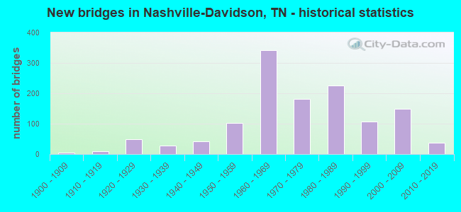
- New bridges - historical statistics
- 1Before 1900
- 41900-1909
- 91910-1919
- 491920-1929
- 271930-1939
- 411940-1949
- 1031950-1959
- 3411960-1969
- 1811970-1979
- 2261980-1989
- 1061990-1999
- 1482000-2009
- 382010-2019
- 12020-2022

- Reconstructed bridges - Historical Statistics
- 51940-1949
- 61950-1959
- 131960-1969
- 71970-1979
- 371980-1989
- 331990-1999
- 272000-2009
- 42010-2019
- 42020-2022


- Bridge Condition - Deck
- 9.6%Very good
- 45.7%Good
- 29.1%Satisfactory
- 14.6%Fair
- 1.0%Poor

- Bridge Condition - Superstructure
- 8.5%Very good
- 54.5%Good
- 21.9%Satisfactory
- 12.2%Fair
- 2.7%Poor
- 0.2%Serious

- Bridge Condition - Substructure
- 7.4%Very good
- 60.2%Good
- 17.4%Satisfactory
- 11.8%Fair
- 3.3%Poor

- Bridge Condition - Channel
- 4.5%Very good
- 34.2%Good
- 47.1%Satisfactory
- 13.4%Fair
- 0.8%Poor

- Bridge Condition - Culverts
- 1.9%Very good
- 63.9%Good
- 24.2%Satisfactory
- 8.1%Fair
- 1.9%Poor
Find on map >> Show street view
Structure Number: 19I00650069, Location: .3 M N JCT I24&I65 (Lat: 36.231061, Lng: -86.770375), Route carried "on" structure: Interstate 65, Year Built: 1964, Status: Open, Structure Length: 1.13m (3.71ft), Average Daily Traffic: 92,300 (year 2020), Truck Traffic: 28%, Average Future Daily Traffic: 174,064 (year 2040), Design Load: HS 20, Features Intersected: EWING CREEK
Minimum Vertical Clearance: 30+ m (98+ ft), Kilometerpoint: 21.646, Lanes on structure: 6, Base Highway Network: Yes (Inventory Route: 19I00650, Subroute: 1), Owner: State Highway Agency, Approaching Roadway Width: 32.9m (107.9ft), Skew: 14 degrees, Material/Design: Concrete continuous, Design/Construction: Culvert, Number Of Spans In Main Unit: 2, Length of Maximum Span: 3.0m (9.8ft)
Condition: Channel: Satisfactory, Culverts: Good, Operating Rating: 89.1 metric tons, Method Used To Determine Operating Rating: Load Factor (LF), Inventory Rating: 32.4 metric tons, Method Used To Determine Inventory Rating: Load Factor (LF), Structural Evaluation: Better than present minimum criteria, Waterway Adequacy: Better than present minimum criteria, Approach Roadway Alignment: Equal to present desirable criteria, Length Of Structure Improvement: 1.13m (3.71ft), Designated Inspection Frequency: Every 24 months, Inspection Date: Febuary 2022, Bridge Improvement Cost: $484,000, Roadway Improvement Cost: $49,000, Total Project Cost: $727,000 ( Estimate for 2020)
Find on map >> Show street view
Structure Number: 19I00650071, Location: DICKERSON PK/I65 (Lat: 36.237281, Lng: -86.757917), Route carried "on" structure: US 31, Year Built: 2005, Status: Open, Structure Length: 11.37m (37.30ft), Average Daily Traffic: 17,365 (year 2020), Truck Traffic: 9%, Average Future Daily Traffic: 27,784 (year 2042), Design Load: HS 20, Features Intersected: DICKERSON PIKE / I65, Facility Carried by Structure: FAU 11
Minimum Vertical Clearance: 30+ m (98+ ft), Kilometerpoint: 27.616, Lanes on structure: 6, Lanes under structure: 13, Base Highway Network: Yes (Inventory Route: 19SR0110, Subroute: 1), Owner: State Highway Agency, Approaching Roadway Width: 29.3m (96.1ft), Skew: 22 degrees, Material/Design: Steel continuous, Design/Construction: Stringer/Multi-beam, Number Of Spans In Main Unit: 2, Length of Maximum Span: 56.1m (184.1ft), Curb-To-Curb Width: 29.3m (96.1ft), Out-to-Out Width: 29.9m (98.1ft)
Condition: Deck: Satisfactory, Superstructure: Good, Substructure: Good, Operating Rating: 78.3 metric tons, Method Used To Determine Operating Rating: Load Factor (LF), Inventory Rating: 46.8 metric tons, Method Used To Determine Inventory Rating: Load Factor (LF), Structural Evaluation: Better than present minimum criteria, Deck Geometry: Superior to present desirable criteria, Underclear: Equal to present minimum criteria, Approach Roadway Alignment: Equal to present desirable criteria, Designated Inspection Frequency: Every 24 months, Inspection Date: Febuary 2022, Deck Structure Type: Concrete Cast-file-Place, Wearing Surface/Protective System: Wearing Surface: Monolithic Concrete, Deck Protection: Epoxy Coated Reinforcing
Find on map >> Show street view
Structure Number: 19I00650073, Location: BRILEY PARKWAY (Lat: 36.240681, Lng: -86.751194), Route carried "on" structure: State highway 155, Year Built: 2005, Status: Open, Structure Length: 12.95m (42.49ft), Average Daily Traffic: 64,364 (year 2020), Truck Traffic: 13%, Average Future Daily Traffic: 102,982 (year 2042), Design Load: HS 20, Features Intersected: BRILEY PKWY / I65
Minimum Vertical Clearance: 30+ m (98+ ft), Kilometerpoint: 24.349, Lanes on structure: 6, Lanes under structure: 14, Base Highway Network: Yes (Inventory Route: 19SR1550, Subroute: 1), Owner: State Highway Agency, Approaching Roadway Width: 32.3m (106.0ft), Skew: 34 degrees, Material/Design: Steel continuous, Design/Construction: Stringer/Multi-beam, Number Of Spans In Main Unit: 2, Length of Maximum Span: 69.5m (228.0ft), Curb-To-Curb Width: 32.3m (106.0ft), Out-to-Out Width: 32.9m (107.9ft)
Condition: Deck: Fair, Superstructure: Good, Substructure: Good, Operating Rating: 36.9 metric tons, Method Used To Determine Operating Rating: Load and Resistance Factor Rating (LRFR) rating reported by rating factor(RF) method using HL-93 loadings, Inventory Rating: 28.5 metric tons, Method Used To Determine Inventory Rating: Load and Resistance Factor Rating (LRFR) rating reported by rating factor(RF) method using HL-93 loadings, Structural Evaluation: Better than present minimum criteria, Deck Geometry: Superior to present desirable criteria, Underclear: Somewhat better than minimum adequacy, Approach Roadway Alignment: Equal to present desirable criteria, Designated Inspection Frequency: Every 24 months, Inspection Date: Febuary 2022, Deck Structure Type: Concrete Cast-file-Place, Wearing Surface/Protective System: Wearing Surface: Monolithic Concrete, Deck Protection: Epoxy Coated Reinforcing
Find on map >> Show street view
Structure Number: 19I00650077, Location: IN NASHVILLE (Lat: 36.250086, Lng: -86.741583), Route carried "on" structure: City street 4933, Year Built: 2000, Status: Open, Structure Length: 6.78m (22.24ft), Average Daily Traffic: 16,246 (year 2020), Truck Traffic: 3%, Average Future Daily Traffic: 25,994 (year 2042), Design Load: HS 20, Features Intersected: DUE WEST AVENUE / I65
Minimum Vertical Clearance: 30+ m (98+ ft), Kilometerpoint: 1.786, Lanes on structure: 4, Lanes under structure: 14, Owner: State Highway Agency, Approaching Roadway Width: 15.8m (51.8ft), Material/Design: Steel continuous, Design/Construction: Stringer/Multi-beam, Number Of Spans In Main Unit: 2, Length of Maximum Span: 33.8m (110.9ft), Curb or Sidewalk Widths: Left: 1.5m (4.9ft), Right: 1.5m (4.9ft), Curb-To-Curb Width: 15.8m (51.8ft), Out-to-Out Width: 19.5m (64.0ft)
Condition: Deck: Good, Superstructure: Good, Substructure: Good, Operating Rating: 44.1 metric tons, Method Used To Determine Operating Rating: Assigned rating based on Load Factor Design (LFD) reported in metric tons, Inventory Rating: 32.4 metric tons, Method Used To Determine Inventory Rating: Assigned rating based on Load Factor Design (LFD) reported in metric tons, Structural Evaluation: Better than present minimum criteria, Deck Geometry: Meets minimum limits, Underclear: Somewhat better than minimum adequacy, Approach Roadway Alignment: Equal to present desirable criteria, Length Of Structure Improvement: 6.78m (22.24ft), Designated Inspection Frequency: Every 24 months, Inspection Date: Febuary 2022, Bridge Improvement Cost: $519,000, Roadway Improvement Cost: $52,000, Total Project Cost: $779,000 ( Estimate for 2022), Deck Structure Type: Concrete Cast-file-Place, Wearing Surface/Protective System: Wearing Surface: Monolithic Concrete, Deck Protection: Epoxy Coated Reinforcing
Find on map >> Show street view
Structure Number: 19I00650079, Location: IN NASHVILLE (Lat: 36.255411, Lng: -86.738747), Route carried "on" structure: City street 266, Year Built: 2003, Status: Open, Structure Length: 6.71m (22.01ft), Average Daily Traffic: 800 (year 2022), Truck Traffic: 2%, Average Future Daily Traffic: 1,280 (year 2042), Design Load: HS 20, Features Intersected: CHADWELL DRIVE / I65
Minimum Vertical Clearance: 30+ m (98+ ft), Kilometerpoint: 0.319, Lanes on structure: 4, Lanes under structure: 10, Owner: State Highway Agency, Approaching Roadway Width: 8.5m (27.9ft), Material/Design: Prestressed concrete continuous, Design/Construction: Stringer/Multi-beam, Number Of Spans In Main Unit: 2, Length of Maximum Span: 32.9m (107.9ft), Curb or Sidewalk Widths: Left: 1.5m (4.9ft), Right: 1.5m (4.9ft), Curb-To-Curb Width: 8.5m (27.9ft), Out-to-Out Width: 12.2m (40.0ft)
Condition: Deck: Good, Superstructure: Good, Substructure: Good, Operating Rating: 68.4 metric tons, Method Used To Determine Operating Rating: Load Factor (LF), Inventory Rating: 32.4 metric tons, Method Used To Determine Inventory Rating: Load Factor (LF), Structural Evaluation: Better than present minimum criteria, Deck Geometry: High priority of replacement, Underclear: Equal to present minimum criteria, Approach Roadway Alignment: Equal to present desirable criteria, Designated Inspection Frequency: Every 24 months, Inspection Date: Febuary 2022, Deck Structure Type: Concrete Cast-file-Place, Wearing Surface/Protective System: Wearing Surface: Monolithic Concrete, Deck Protection: Epoxy Coated Reinforcing
Find on map >> Show street view
Structure Number: 19I00650081, Location: EXIT 92 (MADISON EXIT) (Lat: 36.264789, Lng: -86.737856), Route carried "on" structure: State highway 45, Year Built: 2006, Status: Open, Structure Length: 9.88m (32.41ft), Average Daily Traffic: 23,110 (year 2020), Truck Traffic: 9%, Average Future Daily Traffic: 36,976 (year 2042), Design Load: HS 20, Features Intersected: OLD HICKORY BLVD / I65
Minimum Vertical Clearance: 30+ m (98+ ft), Kilometerpoint: 9.238, Lanes on structure: 5, Lanes under structure: 12, Base Highway Network: Yes, Owner: State Highway Agency, Approaching Roadway Width: 22.0m (72.2ft), Skew: 11 degrees, Material/Design: Steel continuous, Design/Construction: Stringer/Multi-beam, Number Of Spans In Main Unit: 2, Length of Maximum Span: 49.4m (162.1ft), Curb-To-Curb Width: 25.0m (82.0ft), Out-to-Out Width: 26.2m (86.0ft)
Condition: Deck: Good, Superstructure: Good, Substructure: Good, Operating Rating: 45.0 metric tons, Method Used To Determine Operating Rating: Load and Resistance Factor Rating (LRFR) rating reported by rating factor(RF) method using HL-93 loadings, Inventory Rating: 35.0 metric tons, Method Used To Determine Inventory Rating: Load and Resistance Factor Rating (LRFR) rating reported by rating factor(RF) method using HL-93 loadings, Structural Evaluation: Better than present minimum criteria, Deck Geometry: Superior to present desirable criteria, Underclear: Equal to present minimum criteria, Approach Roadway Alignment: Equal to present desirable criteria, Designated Inspection Frequency: Every 24 months, Inspection Date: Febuary 2022, Deck Structure Type: Concrete Precast Panels, Wearing Surface/Protective System: Wearing Surface: Monolithic Concrete
Find on map >> Show street view
Structure Number: 19I00650083, Location: I65/NESBITT LANE (Lat: 36.272225, Lng: -86.735928), Route carried "on" structure: Interstate 65, Year Built: 1964, Year Reconstructed: 1990, Status: Open, Structure Length: 3.24m (10.63ft), Average Daily Traffic: 164,383 (year 2020), Truck Traffic: 28%, Average Future Daily Traffic: 263,013 (year 2042), Design Load: HS 20, Features Intersected: I65 / NESBITT LANE
Minimum Vertical Clearance: 30+ m (98+ ft), Kilometerpoint: 27.649, Lanes on structure: 10, Lanes under structure: 2, Base Highway Network: Yes (Inventory Route: 19I00650, Subroute: 1), Owner: State Highway Agency, Approaching Roadway Width: 26.8m (87.9ft), Skew: 10 degrees, Material/Design: Prestressed concrete, Design/Construction: Stringer/Multi-beam, Number Of Spans In Main Unit: 3, Length of Maximum Span: 11.5m (37.7ft), Curb-To-Curb Width: 52.3m (171.6ft), Out-to-Out Width: 53.3m (174.9ft)
Condition: Deck: Good, Superstructure: Good, Substructure: Good, Operating Rating: 41.4 metric tons, Method Used To Determine Operating Rating: Load Factor (LF), Inventory Rating: 24.8 metric tons, Method Used To Determine Inventory Rating: Load Factor (LF), Structural Evaluation: Equal to present minimum criteria, Deck Geometry: Superior to present desirable criteria, Underclear: Meets minimum limits, Approach Roadway Alignment: Equal to present desirable criteria, Length Of Structure Improvement: 3.24m (10.63ft), Designated Inspection Frequency: Every 24 months, Inspection Date: Febuary 2022, Bridge Improvement Cost: $1,000, Roadway Improvement Cost: $1,000, Total Project Cost: $2,000 ( Estimate for 2022), Deck Structure Type: Concrete Cast-file-Place, Wearing Surface/Protective System: Wearing Surface: Monolithic Concrete, Deck Protection: Epoxy Coated Reinforcing
Find on map >> Show street view
Structure Number: 19I00650085, Location: I65/CUNNIFF PKWY (Lat: 36.283614, Lng: -86.729981), Route carried "on" structure: Interstate 65, Year Built: 1966, Year Reconstructed: 1990, Status: Open, Structure Length: 3.37m (11.06ft), Average Daily Traffic: 164,383 (year 2020), Truck Traffic: 28%, Average Future Daily Traffic: 263,013 (year 2042), Design Load: HS 20, Features Intersected: I65 / CUNNIFF PARKWAY
Minimum Vertical Clearance: 30+ m (98+ ft), Kilometerpoint: 29.017, Lanes on structure: 6, Lanes under structure: 2, Base Highway Network: Yes (Inventory Route: 19I00650, Subroute: 1), Owner: State Highway Agency, Approaching Roadway Width: 19.2m (63.0ft), Skew: 10 degrees, Material/Design: Prestressed concrete, Design/Construction: Stringer/Multi-beam, Number Of Spans In Main Unit: 3, Length of Maximum Span: 14.5m (47.6ft), Curb-To-Curb Width: 52.1m (170.9ft), Out-to-Out Width: 52.7m (172.9ft)
Condition: Deck: Good, Superstructure: Good, Substructure: Good, Operating Rating: 76.5 metric tons, Method Used To Determine Operating Rating: Load Factor (LF), Inventory Rating: 32.4 metric tons, Method Used To Determine Inventory Rating: Load Factor (LF), Structural Evaluation: Better than present minimum criteria, Deck Geometry: Superior to present desirable criteria, Underclear: Meets minimum limits, Approach Roadway Alignment: Equal to present desirable criteria, Designated Inspection Frequency: Every 24 months, Inspection Date: Febuary 2022, Deck Structure Type: Concrete Precast Panels, Wearing Surface/Protective System: Wearing Surface: Monolithic Concrete, Deck Protection: Epoxy Coated Reinforcing
Find on map >> Show street view
Structure Number: 19I00650087, Location: 2.0 M N SR45&I65 (Lat: 36.287892, Lng: -86.725492), Route carried "on" structure: Interstate 65, Year Built: 1966, Status: Open, Structure Length: 0.79m (2.59ft), Average Daily Traffic: 164,383 (year 2020), Truck Traffic: 28%, Average Future Daily Traffic: 263,013 (year 2042), Design Load: HS 20, Features Intersected: BRANCH
Minimum Vertical Clearance: 30+ m (98+ ft), Kilometerpoint: 29.693, Lanes on structure: 6, Base Highway Network: Yes (Inventory Route: 19I00650, Subroute: 1), Owner: State Highway Agency, Approaching Roadway Width: 32.9m (107.9ft), Skew: 14 degrees, Material/Design: Concrete continuous, Design/Construction: Culvert, Number Of Spans In Main Unit: 2, Length of Maximum Span: 2.4m (7.9ft)
Condition: Channel: Good, Culverts: Good, Operating Rating: 89.1 metric tons, Method Used To Determine Operating Rating: Load Factor (LF), Inventory Rating: 77.4 metric tons, Method Used To Determine Inventory Rating: Load Factor (LF), Structural Evaluation: Better than present minimum criteria, Waterway Adequacy: Better than present minimum criteria, Approach Roadway Alignment: Equal to present desirable criteria, Length Of Structure Improvement: 0.79m (2.59ft), Designated Inspection Frequency: Every 24 months, Inspection Date: Febuary 2022, Bridge Improvement Cost: $349,000, Roadway Improvement Cost: $35,000, Total Project Cost: $524,000 ( Estimate for 2022)
Find on map >> Show street view
Structure Number: 19I00650089, Location: IN NASHVILLE (Lat: 36.297781, Lng: -86.713936), Route carried "on" structure: City street 4930, Year Built: 1988, Status: Open, Structure Length: 7.92m (25.98ft), Average Daily Traffic: 9,335 (year 2020), Truck Traffic: 3%, Average Future Daily Traffic: 14,936 (year 2042), Design Load: HS 20, Features Intersected: ALTA LOMA ROAD / I65
Minimum Vertical Clearance: 30+ m (98+ ft), Kilometerpoint: 0.853, Lanes on structure: 2, Lanes under structure: 6, Owner: State Highway Agency, Approaching Roadway Width: 10.4m (34.1ft), Skew: 1 degrees, Material/Design: Steel continuous, Design/Construction: Stringer/Multi-beam, Number Of Spans In Main Unit: 2, Length of Maximum Span: 39.3m (128.9ft), Curb or Sidewalk Widths: Left: 1.7m (5.6ft), Right: 1.7m (5.6ft), Curb-To-Curb Width: 11.0m (36.1ft), Out-to-Out Width: 14.9m (48.9ft)
Condition: Deck: Good, Superstructure: Good, Substructure: Good, Operating Rating: 44.1 metric tons, Method Used To Determine Operating Rating: Assigned rating based on Load Factor Design (LFD) reported in metric tons, Inventory Rating: 32.4 metric tons, Method Used To Determine Inventory Rating: Assigned rating based on Load Factor Design (LFD) reported in metric tons, Structural Evaluation: Better than present minimum criteria, Deck Geometry: Meets minimum limits, Underclear: Meets minimum limits, Approach Roadway Alignment: Equal to present desirable criteria, Designated Inspection Frequency: Every 24 months, Inspection Date: Febuary 2022, Deck Structure Type: Concrete Cast-file-Place, Wearing Surface/Protective System: Wearing Surface: Monolithic Concrete, Deck Protection: Epoxy Coated Reinforcing
Find on map >> Show street view
Structure Number: 19I00650091, Location: .05 M S JCT I65&TWO MILE (Lat: 36.306222, Lng: -86.706031), Route carried "on" structure: Interstate 65, Year Built: 1963, Year Reconstructed: 1997, Status: Open, Structure Length: 7.74m (25.39ft), Average Daily Traffic: 94,057 (year 2020), Truck Traffic: 13%, Average Future Daily Traffic: 150,491 (year 2042), Design Load: HS 20, Features Intersected: CSX RAILROAD
Minimum Vertical Clearance: 30+ m (98+ ft), Kilometerpoint: 32.348, Lanes on structure: 8, Base Highway Network: Yes (Inventory Route: 19I00650, Subroute: 1), Owner: State Highway Agency, Approaching Roadway Width: 12.8m (42.0ft), Skew: 36 degrees, Material/Design: Steel continuous, Design/Construction: Stringer/Multi-beam, Number Of Spans In Main Unit: 3, Length of Maximum Span: 26.8m (87.9ft), Curb-To-Curb Width: 44.3m (145.3ft), Out-to-Out Width: 45.0m (147.6ft)
Condition: Deck: Satisfactory, Superstructure: Good, Substructure: Good, Operating Rating: 74.7 metric tons, Method Used To Determine Operating Rating: Load Factor (LF), Inventory Rating: 32.4 metric tons, Method Used To Determine Inventory Rating: Load Factor (LF), Structural Evaluation: Better than present minimum criteria, Deck Geometry: Superior to present desirable criteria, Underclear: Equal to present minimum criteria, Approach Roadway Alignment: Equal to present desirable criteria, Designated Inspection Frequency: Every 24 months, Inspection Date: Febuary 2022, Deck Structure Type: Concrete Cast-file-Place, Wearing Surface/Protective System: Wearing Surface: Monolithic Concrete, Deck Protection: Epoxy Coated Reinforcing
Find on map >> Show street view
Structure Number: 19I00650093, Location: I65/TWO MILE PK (Lat: 36.308186, Lng: -86.704325), Route carried "on" structure: Interstate 65, Year Built: 1968, Year Reconstructed: 1998, Status: Open, Structure Length: 6.61m (21.69ft), Average Daily Traffic: 94,057 (year 2020), Truck Traffic: 13%, Average Future Daily Traffic: 150,491 (year 2042), Design Load: HS 20, Features Intersected: I65 / RIVERGATE PKWY
Minimum Vertical Clearance: 30+ m (98+ ft), Kilometerpoint: 32.605, Lanes on structure: 7, Lanes under structure: 4, Base Highway Network: Yes (Inventory Route: 19I00650, Subroute: 1), Owner: State Highway Agency, Approaching Roadway Width: 38.4m (126.0ft), Skew: 33 degrees, Material/Design: Steel continuous, Design/Construction: Stringer/Multi-beam, Number Of Spans In Main Unit: 4, Length of Maximum Span: 18.3m (60.0ft), Curb-To-Curb Width: 38.4m (126.0ft), Out-to-Out Width: 39.0m (128.0ft)
Condition: Deck: Good, Superstructure: Good, Substructure: Fair, Operating Rating: 76.5 metric tons, Method Used To Determine Operating Rating: Load Factor (LF), Inventory Rating: 32.4 metric tons, Method Used To Determine Inventory Rating: Load Factor (LF), Structural Evaluation: Somewhat better than minimum adequacy, Deck Geometry: Superior to present desirable criteria, Underclear: Equal to present minimum criteria, Approach Roadway Alignment: Equal to present desirable criteria, Designated Inspection Frequency: Every 24 months, Inspection Date: Febuary 2022, Deck Structure Type: Concrete Cast-file-Place, Wearing Surface/Protective System: Wearing Surface: Monolithic Concrete, Deck Protection: Epoxy Coated Reinforcing
Find on map >> Show street view
Structure Number: 19I00650095, Location: .05 M S JCT SR174&I65 (Lat: 36.325672, Lng: -86.705744), Route carried "on" structure: Interstate 65, Year Built: 1977, Status: Open, Structure Length: 1.13m (3.71ft), Average Daily Traffic: 98,206 (year 2020), Truck Traffic: 13%, Average Future Daily Traffic: 157,130 (year 2042), Design Load: HS 20, Features Intersected: BRANCH
Minimum Vertical Clearance: 30+ m (98+ ft), Kilometerpoint: 34.730, Lanes on structure: 4, Base Highway Network: Yes (Inventory Route: 19I00650, Subroute: 1), Owner: State Highway Agency, Approaching Roadway Width: 41.8m (137.1ft), Skew: 13 degrees, Material/Design: Concrete continuous, Design/Construction: Culvert, Number Of Spans In Main Unit: 2, Length of Maximum Span: 3.7m (12.1ft)
Condition: Channel: Good, Culverts: Good, Operating Rating: 89.1 metric tons, Method Used To Determine Operating Rating: Load Factor (LF), Inventory Rating: 32.4 metric tons, Method Used To Determine Inventory Rating: Load Factor (LF), Structural Evaluation: Better than present minimum criteria, Waterway Adequacy: Better than present minimum criteria, Approach Roadway Alignment: Equal to present desirable criteria, Length Of Structure Improvement: 1.13m (3.71ft), Designated Inspection Frequency: Every 24 months, Inspection Date: Febuary 2022, Bridge Improvement Cost: $377,000, Roadway Improvement Cost: $38,000, Total Project Cost: $566,000 ( Estimate for 2022)
Find on map >> Show street view
Structure Number: 19I00650097, Location: I65/EAST CEDAR ST (Lat: 36.325842, Lng: -86.705808), Route carried "on" structure: Interstate 65, Year Built: 1968, Year Reconstructed: 1994, Status: Open, Structure Length: 4.05m (13.29ft), Average Daily Traffic: 98,206 (year 2020), Truck Traffic: 13%, Average Future Daily Traffic: 157,130 (year 2042), Design Load: HS 20, Features Intersected: I65 RL / EAST CEDAR ST
Minimum Vertical Clearance: 30+ m (98+ ft), Kilometerpoint: 34.730, Lanes on structure: 3, Lanes under structure: 2, Base Highway Network: Yes (Inventory Route: 19I00650, Subroute: 1), Owner: State Highway Agency, Approaching Roadway Width: 16.5m (54.1ft), Skew: 10 degrees, Material/Design: Prestressed concrete continuous, Design/Construction: Stringer/Multi-beam, Number Of Spans In Main Unit: 3, Length of Maximum Span: 16.8m (55.1ft), Curb-To-Curb Width: 15.8m (51.8ft), Out-to-Out Width: 16.5m (54.1ft)
Condition: Deck: Good, Superstructure: Good, Substructure: Good, Operating Rating: 76.5 metric tons, Method Used To Determine Operating Rating: Load Factor (LF), Inventory Rating: 32.4 metric tons, Method Used To Determine Inventory Rating: Load Factor (LF), Structural Evaluation: Better than present minimum criteria, Deck Geometry: Somewhat better than minimum adequacy, Underclear: Better than present minimum criteria, Approach Roadway Alignment: Equal to present desirable criteria, Length Of Structure Improvement: 4.05m (13.29ft), Designated Inspection Frequency: Every 24 months, Inspection Date: Febuary 2022, Bridge Improvement Cost: $247,000, Roadway Improvement Cost: $25,000, Total Project Cost: $371,000 ( Estimate for 2022), Deck Structure Type: Concrete Cast-file-Place, Wearing Surface/Protective System: Wearing Surface: Bituminous
Find on map >> Show street view
Structure Number: 19I00650098, Location: I65-EAST CEDARST (Lat: 36.325711, Lng: -86.706097), Route carried "on" structure: Interstate 65, Year Built: 1968, Year Reconstructed: 1994, Status: Open, Structure Length: 4.05m (13.29ft), Average Daily Traffic: 98,206 (year 2020), Truck Traffic: 13%, Average Future Daily Traffic: 157,130 (year 2042), Design Load: HS 20, Features Intersected: I65 LL / EAST CEDAR ST
Minimum Vertical Clearance: 30+ m (98+ ft), Kilometerpoint: 34.730, Lanes on structure: 3, Lanes under structure: 2, Base Highway Network: Yes (Inventory Route: 19I00650, Subroute: 1), Owner: State Highway Agency, Approaching Roadway Width: 16.5m (54.1ft), Skew: 10 degrees, Material/Design: Prestressed concrete continuous, Design/Construction: Stringer/Multi-beam, Number Of Spans In Main Unit: 3, Length of Maximum Span: 16.8m (55.1ft), Curb-To-Curb Width: 15.8m (51.8ft), Out-to-Out Width: 16.5m (54.1ft)
Condition: Deck: Good, Superstructure: Good, Substructure: Good, Operating Rating: 76.5 metric tons, Method Used To Determine Operating Rating: Load Factor (LF), Inventory Rating: 32.4 metric tons, Method Used To Determine Inventory Rating: Load Factor (LF), Structural Evaluation: Better than present minimum criteria, Deck Geometry: Somewhat better than minimum adequacy, Underclear: Equal to present minimum criteria, Approach Roadway Alignment: Equal to present desirable criteria, Length Of Structure Improvement: 4.05m (13.29ft), Designated Inspection Frequency: Every 24 months, Inspection Date: Febuary 2022, Bridge Improvement Cost: $247,000, Roadway Improvement Cost: $25,000, Total Project Cost: $371,000 ( Estimate for 2022), Deck Structure Type: Concrete Cast-file-Place, Wearing Surface/Protective System: Wearing Surface: Bituminous
Find on map >> Show street view
Structure Number: 19I00650099, Location: 1 MI S OF SR41 (Lat: 36.333514, Lng: -86.709569), Route carried "on" structure: Interstate 65, Year Built: 1968, Status: Open, Structure Length: 8.50m (27.89ft), Average Daily Traffic: 98,206 (year 2020), Truck Traffic: 13%, Average Future Daily Traffic: 157,130 (year 2042), Design Load: HS 20, Features Intersected: MANSKER CREEK
Minimum Vertical Clearance: 30+ m (98+ ft), Kilometerpoint: 35.647, Lanes on structure: 2, Base Highway Network: Yes (Inventory Route: 19I00650, Subroute: 1), Owner: State Highway Agency, Approaching Roadway Width: 12.8m (42.0ft), Skew: 14 degrees, Material/Design: Prestressed concrete continuous, Design/Construction: Stringer/Multi-beam, Number Of Spans In Main Unit: 4, Length of Maximum Span: 21.0m (68.9ft), Curb-To-Curb Width: 12.2m (40.0ft), Out-to-Out Width: 12.8m (42.0ft)
Condition: Deck: Good, Superstructure: Good, Substructure: Good, Channel: Satisfactory, Operating Rating: 57.6 metric tons, Method Used To Determine Operating Rating: Load Factor (LF), Inventory Rating: 32.4 metric tons, Method Used To Determine Inventory Rating: Load Factor (LF), Structural Evaluation: Better than present minimum criteria, Deck Geometry: Better than present minimum criteria, Waterway Adequacy: Better than present minimum criteria, Approach Roadway Alignment: Equal to present desirable criteria, Designated Inspection Frequency: Every 24 months, Inspection Date: Febuary 2022, Deck Structure Type: Concrete Cast-file-Place, Wearing Surface/Protective System: Wearing Surface: Bituminous
Find on map >> Show street view
Structure Number: 19I006501, Location: 1 MI S OF SR41 (Lat: 36.333742, Lng: -86.710047), Route carried "on" structure: Interstate 65, Year Built: 1968, Status: Open, Structure Length: 8.50m (27.89ft), Average Daily Traffic: 98,206 (year 2020), Truck Traffic: 13%, Average Future Daily Traffic: 157,130 (year 2042), Design Load: HS 20, Features Intersected: MANSKER CREEK
Minimum Vertical Clearance: 30+ m (98+ ft), Kilometerpoint: 35.647, Lanes on structure: 2, Base Highway Network: Yes (Inventory Route: 19I00650, Subroute: 1), Owner: State Highway Agency, Approaching Roadway Width: 12.8m (42.0ft), Skew: 14 degrees, Material/Design: Prestressed concrete continuous, Design/Construction: Stringer/Multi-beam, Number Of Spans In Main Unit: 4, Length of Maximum Span: 21.0m (68.9ft), Curb-To-Curb Width: 12.2m (40.0ft), Out-to-Out Width: 12.8m (42.0ft)
Condition: Deck: Good, Superstructure: Good, Substructure: Good, Channel: Satisfactory, Operating Rating: 57.6 metric tons, Method Used To Determine Operating Rating: Load Factor (LF), Inventory Rating: 32.4 metric tons, Method Used To Determine Inventory Rating: Load Factor (LF), Structural Evaluation: Better than present minimum criteria, Deck Geometry: Better than present minimum criteria, Waterway Adequacy: Better than present minimum criteria, Approach Roadway Alignment: Equal to present desirable criteria, Designated Inspection Frequency: Every 24 months, Inspection Date: Febuary 2022, Deck Structure Type: Concrete Cast-file-Place, Wearing Surface/Protective System: Wearing Surface: Bituminous
Find on map >> Show street view
Structure Number: 19I00650103, Location: NEAR I-65-I24 INTERCHANGE (Lat: 36.223550, Lng: -86.774139), Route carried "on" structure: Ramp Interstate 65, Year Built: 2000, Status: Open, Structure Length: 16.76m (54.99ft), Average Daily Traffic: 135,743 (year 2020), Truck Traffic: 28%, Average Future Daily Traffic: 217,189 (year 2042), Design Load: HS 20, Features Intersected: I65 RMP B STR 14 / I65 S
Minimum Vertical Clearance: 30+ m (98+ ft), Kilometerpoint: 20.745, Lanes on structure: 2, Lanes under structure: 4, Base Highway Network: Yes (Inventory Route: 19I00650, Subroute: 1), Owner: State Highway Agency, Approaching Roadway Width: 12.8m (42.0ft), Material/Design: Steel continuous, Design/Construction: Stringer/Multi-beam, Number Of Spans In Main Unit: 3, Length of Maximum Span: 67.1m (220.1ft), Curb-To-Curb Width: 12.8m (42.0ft), Out-to-Out Width: 13.4m (44.0ft)
Condition: Deck: Fair, Superstructure: Good, Substructure: Good, Operating Rating: 29.2 metric tons, Method Used To Determine Operating Rating: Load and Resistance Factor Rating (LRFR) rating reported by rating factor(RF) method using HL-93 loadings, Inventory Rating: 22.4 metric tons, Method Used To Determine Inventory Rating: Load and Resistance Factor Rating (LRFR) rating reported by rating factor(RF) method using HL-93 loadings, Structural Evaluation: Somewhat better than minimum adequacy, Deck Geometry: Superior to present desirable criteria, Underclear: Equal to present minimum criteria, Approach Roadway Alignment: Equal to present desirable criteria, Length Of Structure Improvement: 16.76m (54.99ft), Designated Inspection Frequency: Every 24 months, Inspection Date: January 2022, Bridge Improvement Cost: $386,000, Roadway Improvement Cost: $39,000, Total Project Cost: $580,000 ( Estimate for 2022), Deck Structure Type: Concrete Precast Panels, Wearing Surface/Protective System: Wearing Surface: Monolithic Concrete, Deck Protection: Epoxy Coated Reinforcing
Find on map >> Show street view
Structure Number: 19I00650105, Location: I65-BERRY RD (Lat: 36.119031, Lng: -86.773497), Route carried "on" structure: Interstate 65, Year Built: 1972, Status: Open, Structure Length: 2.96m (9.71ft), Average Daily Traffic: 117,786 (year 2020), Truck Traffic: 7%, Average Future Daily Traffic: 188,458 (year 2042), Design Load: HS 20, Features Intersected: I65 / BERRY ROAD
Minimum Vertical Clearance: 30+ m (98+ ft), Kilometerpoint: 9.962, Lanes on structure: 4, Lanes under structure: 4, Base Highway Network: Yes, Owner: State Highway Agency, Approaching Roadway Width: 31.7m (104.0ft), Skew: 1 degrees, Material/Design: Prestressed concrete, Design/Construction: Box Beam or Girders - Multiple, Number Of Spans In Main Unit: 1, Length of Maximum Span: 29.3m (96.1ft), Curb or Sidewalk Widths: Left: 0.6m (2.0ft), Right: 0.6m (2.0ft), Curb-To-Curb Width: 31.7m (104.0ft), Out-to-Out Width: 32.3m (106.0ft)
Condition: Deck: Good, Superstructure: Satisfactory, Substructure: Good, Operating Rating: 52.7 metric tons, Method Used To Determine Operating Rating: Load Factor (LF), Inventory Rating: 31.6 metric tons, Method Used To Determine Inventory Rating: Load Factor (LF), Structural Evaluation: Equal to present minimum criteria, Deck Geometry: Superior to present desirable criteria, Underclear: Meets minimum limits, Approach Roadway Alignment: Equal to present desirable criteria, Designated Inspection Frequency: Every 24 months, Inspection Date: January 2022, Deck Structure Type: Concrete Cast-file-Place, Wearing Surface/Protective System: Wearing Surface: Bituminous, Membrane: Built-up
Find on map >> Show street view
Structure Number: 19I00650107, Location: IN GOODLETTSVILLE (Lat: 36.323853, Lng: -86.704828), Route carried "on" structure: Interstate 65, Year Built: 1977, Status: Open, Structure Length: 4.75m (15.58ft), Average Daily Traffic: 96,143 (year 2020), Truck Traffic: 13%, Average Future Daily Traffic: 153,829 (year 2042), Design Load: HS 20, Features Intersected: I65 RL / LONG HOLLOW PIK
Minimum Vertical Clearance: 30+ m (98+ ft), Kilometerpoint: 34.488, Lanes on structure: 2, Lanes under structure: 4, Base Highway Network: Yes (Inventory Route: 19I00650, Subroute: 1), Owner: State Highway Agency, Approaching Roadway Width: 12.8m (42.0ft), Material/Design: Concrete continuous, Design/Construction: Frame, Number Of Spans In Main Unit: 3, Length of Maximum Span: 28.7m (94.2ft), Curb-To-Curb Width: 12.8m (42.0ft), Out-to-Out Width: 13.4m (44.0ft)
Condition: Deck: Good, Superstructure: Good, Substructure: Good, Operating Rating: 40.8 metric tons, Method Used To Determine Operating Rating: Load and Resistance Factor Rating (LRFR) rating reported by rating factor(RF) method using HL-93 loadings, Inventory Rating: 32.4 metric tons, Method Used To Determine Inventory Rating: Load and Resistance Factor Rating (LRFR) rating reported by rating factor(RF) method using HL-93 loadings, Structural Evaluation: Better than present minimum criteria, Deck Geometry: Equal to present desirable criteria, Underclear: Somewhat better than minimum adequacy, Approach Roadway Alignment: Equal to present desirable criteria, Designated Inspection Frequency: Every 24 months, Other Special Inspection Frequency: Every 24 months, Inspection Date: Febuary 2022, Other Special Inspection Date: Febuary 2022, Deck Structure Type: Concrete Cast-file-Place, Wearing Surface/Protective System: Wearing Surface: Bituminous
Find on map >> Show street view
Structure Number: 19I00650108, Location: IN GOODLETTSVILLE (Lat: 36.323772, Lng: -86.705094), Route carried "on" structure: Interstate 65, Year Built: 1977, Status: Open, Structure Length: 4.75m (15.58ft), Average Daily Traffic: 96,143 (year 2020), Truck Traffic: 13%, Average Future Daily Traffic: 153,829 (year 2042), Design Load: HS 20, Features Intersected: I65 LL / LONG HOLLOW PIK
Minimum Vertical Clearance: 30+ m (98+ ft), Kilometerpoint: 34.488, Lanes on structure: 2, Lanes under structure: 4, Base Highway Network: Yes (Inventory Route: 19I00650, Subroute: 1), Owner: State Highway Agency, Approaching Roadway Width: 12.8m (42.0ft), Material/Design: Concrete continuous, Design/Construction: Frame, Number Of Spans In Main Unit: 3, Length of Maximum Span: 28.7m (94.2ft), Curb-To-Curb Width: 12.8m (42.0ft), Out-to-Out Width: 13.4m (44.0ft)
Condition: Deck: Good, Superstructure: Good, Substructure: Good, Operating Rating: 40.8 metric tons, Method Used To Determine Operating Rating: Load and Resistance Factor Rating (LRFR) rating reported by rating factor(RF) method using HL-93 loadings, Inventory Rating: 32.4 metric tons, Method Used To Determine Inventory Rating: Load and Resistance Factor Rating (LRFR) rating reported by rating factor(RF) method using HL-93 loadings, Structural Evaluation: Better than present minimum criteria, Deck Geometry: Equal to present desirable criteria, Underclear: Somewhat better than minimum adequacy, Approach Roadway Alignment: Equal to present desirable criteria, Designated Inspection Frequency: Every 24 months, Other Special Inspection Frequency: Every 24 months, Inspection Date: Febuary 2022, Other Special Inspection Date: Febuary 2022, Deck Structure Type: Concrete Cast-file-Place, Wearing Surface/Protective System: Wearing Surface: Bituminous
Find on map >> Show street view
Structure Number: 19I00650111, Location: IN NASHVILLE (Lat: 36.295811, Lng: -86.719611), Route carried "on" structure: Interstate 65, Year Built: 1966, Status: Open, Structure Length: 0.67m (2.20ft), Average Daily Traffic: 164,383 (year 2020), Truck Traffic: 28%, Average Future Daily Traffic: 263,013 (year 2042), Design Load: HS 20, Features Intersected: DRY CREEK
Minimum Vertical Clearance: 30+ m (98+ ft), Kilometerpoint: 30.417, Lanes on structure: 6, Base Highway Network: Yes (Inventory Route: 19I00650, Subroute: 1), Owner: State Highway Agency, Approaching Roadway Width: 32.9m (107.9ft), Material/Design: Concrete continuous, Design/Construction: Culvert, Number Of Spans In Main Unit: 2, Length of Maximum Span: 3.0m (9.8ft)
Condition: Channel: Satisfactory, Culverts: Satisfactory, Operating Rating: 89.1 metric tons, Method Used To Determine Operating Rating: Load Factor (LF), Inventory Rating: 32.4 metric tons, Method Used To Determine Inventory Rating: Load Factor (LF), Structural Evaluation: Equal to present minimum criteria, Waterway Adequacy: Better than present minimum criteria, Approach Roadway Alignment: Equal to present desirable criteria, Length Of Structure Improvement: 0.67m (2.20ft), Designated Inspection Frequency: Every 24 months, Inspection Date: Febuary 2022, Bridge Improvement Cost: $285,000, Roadway Improvement Cost: $29,000, Total Project Cost: $428,000 ( Estimate for 2022)
Find on map >> Show street view
Structure Number: 19I00650113, Location: I440-I65 LOOP@MELROSE I/C (Lat: 36.115772, Lng: -86.774044), Route carried "on" structure: Interstate 440, Year Built: 1985, Year Reconstructed: 2020, Status: Open, Structure Length: 31.57m (103.58ft), Average Daily Traffic: 99,333 (year 2020), Truck Traffic: 7%, Average Future Daily Traffic: 158,933 (year 2041), Design Load: HS 20, Features Intersected: L4-SN167-RL/L3-SN164&165
Minimum Vertical Clearance: 30+ m (98+ ft), Kilometerpoint: 7.821, Lanes on structure: 3, Lanes under structure: 2, Base Highway Network: Yes, Owner: State Highway Agency, Approaching Roadway Width: 14.3m (46.9ft), Material/Design: Steel continuous, Design/Construction: Box Beam or Girders - Single/Spread, Number Of Spans In Main Unit: 6, Length of Maximum Span: 85.9m (281.8ft), Curb-To-Curb Width: 17.7m (58.1ft), Out-to-Out Width: 18.2m (59.7ft)
Condition: Deck: Satisfactory, Superstructure: Satisfactory, Substructure: Satisfactory, Operating Rating: 19.1 metric tons, Method Used To Determine Operating Rating: Load and Resistance Factor Rating (LRFR) rating reported by rating factor(RF) method using HL-93 loadings, Inventory Rating: 14.6 metric tons, Method Used To Determine Inventory Rating: Load and Resistance Factor Rating (LRFR) rating reported by rating factor(RF) method using HL-93 loadings, Structural Evaluation: High priority of corrective action, Deck Geometry: Better than present minimum criteria, Underclear: Somewhat better than minimum adequacy, Approach Roadway Alignment: Better than present minimum criteria, Designated Inspection Frequency: Every 24 months, Critical Feature Inspection Frequency: Every 24 months, Inspection Date: Febuary 2022, Critical Feature Inspection Date: Febuary 2022, Deck Structure Type: Concrete Precast Panels, Wearing Surface/Protective System: Wearing Surface: Monolithic Concrete, Deck Protection: Epoxy Coated Reinforcing
Find on map >> Show street view
Structure Number: 19I00650114, Location: I440-I65 LOOP@MELROSE I/C (Lat: 36.115772, Lng: -86.774044), Route carried "on" structure: Interstate 440, Year Built: 1985, Year Reconstructed: 2020, Status: Open, Structure Length: 31.57m (103.58ft), Average Daily Traffic: 99,333 (year 2020), Truck Traffic: 7%, Average Future Daily Traffic: 158,933 (year 2041), Design Load: HS 20, Features Intersected: L4-SN167-RL/L3-SN164&165
Minimum Vertical Clearance: 30+ m (98+ ft), Kilometerpoint: 7.821, Lanes on structure: 3, Lanes under structure: 2, Base Highway Network: Yes, Owner: State Highway Agency, Approaching Roadway Width: 14.3m (46.9ft), Material/Design: Steel continuous, Design/Construction: Box Beam or Girders - Single/Spread, Number Of Spans In Main Unit: 6, Length of Maximum Span: 85.9m (281.8ft), Curb-To-Curb Width: 17.7m (58.1ft), Out-to-Out Width: 18.2m (59.7ft)
Condition: Deck: Fair, Superstructure: Satisfactory, Substructure: Satisfactory, Operating Rating: 19.8 metric tons, Method Used To Determine Operating Rating: Load and Resistance Factor Rating (LRFR) rating reported by rating factor(RF) method using HL-93 loadings, Inventory Rating: 15.2 metric tons, Method Used To Determine Inventory Rating: Load and Resistance Factor Rating (LRFR) rating reported by rating factor(RF) method using HL-93 loadings, Structural Evaluation: High priority of corrective action, Deck Geometry: Better than present minimum criteria, Underclear: Somewhat better than minimum adequacy, Approach Roadway Alignment: Better than present minimum criteria, Designated Inspection Frequency: Every 24 months, Critical Feature Inspection Frequency: Every 24 months, Inspection Date: Febuary 2022, Critical Feature Inspection Date: Febuary 2022, Deck Structure Type: Concrete Precast Panels, Wearing Surface/Protective System: Wearing Surface: Monolithic Concrete, Deck Protection: Epoxy Coated Reinforcing
Find on map >> Show street view
Structure Number: 19I00650115, Location: IN NASHVILLE @ RIVERGATE (Lat: 36.303864, Lng: -86.708700), Route carried "on" structure: State highway 386, Year Built: 1985, Status: Open, Structure Length: 66.69m (218.80ft), Average Daily Traffic: 71,144 (year 2020), Truck Traffic: 13%, Average Future Daily Traffic: 113,830 (year 2042), Design Load: HS 20, Features Intersected: SR386/I65-1017-A380-CSX
Minimum Vertical Clearance: 30+ m (98+ ft), Kilometerpoint: 0.386, Lanes on structure: 4, Lanes under structure: 12, Base Highway Network: Yes, Owner: State Highway Agency, Approaching Roadway Width: 12.8m (42.0ft), Skew: 2 degrees, Material/Design: Steel continuous, Design/Construction: Stringer/Multi-beam, Number Of Spans In Main Unit: 18, Length of Maximum Span: 54.6m (179.1ft), Curb-To-Curb Width: 38.8m (127.3ft), Out-to-Out Width: 39.4m (129.3ft)
Condition: Deck: Good, Superstructure: Good, Substructure: Good, Operating Rating: 47.7 metric tons, Method Used To Determine Operating Rating: Load Factor (LF), Inventory Rating: 27.9 metric tons, Method Used To Determine Inventory Rating: Load Factor (LF), Structural Evaluation: Better than present minimum criteria, Deck Geometry: Superior to present desirable criteria, Underclear: High priority of corrective action, Approach Roadway Alignment: Equal to present desirable criteria, Length Of Structure Improvement: 66.69m (218.80ft), Designated Inspection Frequency: Every 24 months, Inspection Date: Febuary 2022, Bridge Improvement Cost: $9,467,000, Roadway Improvement Cost: $947,000, Total Project Cost: $14,201,000 ( Estimate for 2022), Deck Structure Type: Concrete Cast-file-Place, Wearing Surface/Protective System: Wearing Surface: Monolithic Concrete, Deck Protection: Epoxy Coated Reinforcing
Find on map >> Show street view
Structure Number: 19I00650117, Location: 1 M. S. SR 155 @ I65 (Lat: 36.101336, Lng: -86.765231), Route carried "on" structure: City street 4888, Year Built: 1985, Status: Posted for load, Structure Length: 34.05m (111.71ft), Average Daily Traffic: 11,073 (year 2020), Truck Traffic: 3%, Average Future Daily Traffic: 17,717 (year 2042), Design Load: HS 20, Features Intersected: ARMORY DR/I65-RR-POWELL
Minimum Vertical Clearance: 30+ m (98+ ft), Kilometerpoint: 0.515, Lanes on structure: 4, Lanes under structure: 11, Owner: State Highway Agency, Approaching Roadway Width: 20.1m (65.9ft), Material/Design: Steel continuous, Design/Construction: Stringer/Multi-beam, Number Of Spans In Main Unit: 9, Length of Maximum Span: 51.2m (168.0ft), Curb-To-Curb Width: 20.1m (65.9ft), Out-to-Out Width: 20.7m (67.9ft)
Condition: Deck: Good, Superstructure: Good, Substructure: Good, Operating Rating: 33.4 metric tons, Method Used To Determine Operating Rating: Load and Resistance Factor Rating (LRFR) rating reported by rating factor(RF) method using HL-93 loadings, Inventory Rating: 25.9 metric tons, Method Used To Determine Inventory Rating: Load and Resistance Factor Rating (LRFR) rating reported by rating factor(RF) method using HL-93 loadings, Structural Evaluation: Equal to present minimum criteria, Deck Geometry: Better than present minimum criteria, Underclear: Equal to present minimum criteria, Approach Roadway Alignment: Equal to present desirable criteria, Designated Inspection Frequency: Every 24 months, Inspection Date: January 2022, Deck Structure Type: Concrete Precast Panels, Wearing Surface/Protective System: Wearing Surface: Monolithic Concrete, Deck Protection: Epoxy Coated Reinforcing
Find on map >> Show street view
Structure Number: 19I00650119, Location: I440-I65 @ MELROSE I/C (Lat: 36.118128, Lng: -86.774578), Route carried "on" structure: Ramp Interstate 65, Year Built: 1985, Status: Posted for load, Structure Length: 12.44m (40.81ft), Average Daily Traffic: 117,786 (year 2020), Truck Traffic: 7%, Average Future Daily Traffic: 188,458 (year 2042), Design Load: HS 20, Features Intersected: FRANKLIN PK. & BERRY RD.
Minimum Vertical Clearance: 30+ m (98+ ft), Kilometerpoint: 9.865, Lanes on structure: 2, Lanes under structure: 4, Base Highway Network: Yes, Owner: State Highway Agency, Approaching Roadway Width: 12.8m (42.0ft), Skew: 10 degrees, Material/Design: Steel continuous, Design/Construction: Stringer/Multi-beam, Number Of Spans In Main Unit: 3, Length of Maximum Span: 61.3m (201.1ft), Curb-To-Curb Width: 12.8m (42.0ft), Out-to-Out Width: 13.4m (44.0ft)
Condition: Deck: Good, Superstructure: Good, Substructure: Good, Operating Rating: 33.7 metric tons, Method Used To Determine Operating Rating: Load and Resistance Factor Rating (LRFR) rating reported by rating factor(RF) method using HL-93 loadings, Inventory Rating: 25.9 metric tons, Method Used To Determine Inventory Rating: Load and Resistance Factor Rating (LRFR) rating reported by rating factor(RF) method using HL-93 loadings, Structural Evaluation: Equal to present minimum criteria, Deck Geometry: Superior to present desirable criteria, Underclear: Meets minimum limits, Approach Roadway Alignment: Equal to present desirable criteria, Designated Inspection Frequency: Every 24 months, Critical Feature Inspection Frequency: Every 24 months, Inspection Date: January 2022, Critical Feature Inspection Date: January 2022, Deck Structure Type: Concrete Precast Panels, Wearing Surface/Protective System: Wearing Surface: Monolithic Concrete, Deck Protection: Epoxy Coated Reinforcing
Find on map >> Show street view
Structure Number: 19I00650121, Location: I440-I65 LOOP@MELROSE I/C (Lat: 36.114822, Lng: -86.773997), Route carried "on" structure: Interstate 440, Year Built: 1985, Status: Open, Structure Length: 21.49m (70.51ft), Average Daily Traffic: 99,333 (year 2020), Truck Traffic: 7%, Average Future Daily Traffic: 174,848 (year 2040), Design Load: HS 20, Features Intersected: L3-SN165-RL /L2-SN162 16
Minimum Vertical Clearance: 5.69m (18.67ft), Kilometerpoint: 7.854, Lanes on structure: 2, Lanes under structure: 2, Base Highway Network: Yes, Owner: State Highway Agency, Approaching Roadway Width: 9.1m (29.9ft), Material/Design: Steel continuous, Design/Construction: Box Beam or Girders - Single/Spread, Number Of Spans In Main Unit: 4, Length of Maximum Span: 58.8m (192.9ft), Curb-To-Curb Width: 9.1m (29.9ft), Out-to-Out Width: 9.8m (32.2ft)
Condition: Deck: Fair, Superstructure: Satisfactory, Substructure: Good, Operating Rating: 26.2 metric tons, Method Used To Determine Operating Rating: Load and Resistance Factor Rating (LRFR) rating reported by rating factor(RF) method using HL-93 loadings, Inventory Rating: 20.1 metric tons, Method Used To Determine Inventory Rating: Load and Resistance Factor Rating (LRFR) rating reported by rating factor(RF) method using HL-93 loadings, Structural Evaluation: Somewhat better than minimum adequacy, Deck Geometry: Meets minimum limits, Underclear: Somewhat better than minimum adequacy, Approach Roadway Alignment: Better than present minimum criteria, Length Of Structure Improvement: 21.49m (70.51ft), Designated Inspection Frequency: Every 24 months, Critical Feature Inspection Frequency: Every 24 months, Inspection Date: Febuary 2022, Critical Feature Inspection Date: Febuary 2022, Bridge Improvement Cost: $1,714,000, Roadway Improvement Cost: $172,000, Total Project Cost: $2,572,000 ( Estimate for 2020), Deck Structure Type: Concrete Precast Panels, Wearing Surface/Protective System: Wearing Surface: Monolithic Concrete, Deck Protection: Epoxy Coated Reinforcing
Find on map >> Show street view
Structure Number: 19I00650122, Location: I440-I65LOOP@MELROSE I/C (Lat: 36.115669, Lng: -86.773972), Route carried "on" structure: Interstate 440, Year Built: 1985, Status: Open, Structure Length: 21.24m (69.69ft), Average Daily Traffic: 99,333 (year 2020), Truck Traffic: 7%, Average Future Daily Traffic: 174,848 (year 2040), Design Load: HS 20, Features Intersected: L3-SN164-LL /L2-SN162&16
Minimum Vertical Clearance: 5.16m (16.93ft), Kilometerpoint: 7.886, Lanes on structure: 2, Lanes under structure: 2, Base Highway Network: Yes, Owner: State Highway Agency, Approaching Roadway Width: 9.1m (29.9ft), Material/Design: Steel continuous, Design/Construction: Box Beam or Girders - Single/Spread, Number Of Spans In Main Unit: 5, Length of Maximum Span: 58.5m (191.9ft), Curb-To-Curb Width: 9.1m (29.9ft), Out-to-Out Width: 9.8m (32.2ft)
Condition: Deck: Satisfactory, Superstructure: Satisfactory, Substructure: Good, Operating Rating: 32.7 metric tons, Method Used To Determine Operating Rating: Load and Resistance Factor Rating (LRFR) rating reported by rating factor(RF) method using HL-93 loadings, Inventory Rating: 25.3 metric tons, Method Used To Determine Inventory Rating: Load and Resistance Factor Rating (LRFR) rating reported by rating factor(RF) method using HL-93 loadings, Structural Evaluation: Equal to present minimum criteria, Deck Geometry: Meets minimum limits, Underclear: Somewhat better than minimum adequacy, Approach Roadway Alignment: Better than present minimum criteria, Length Of Structure Improvement: 21.24m (69.69ft), Designated Inspection Frequency: Every 24 months, Critical Feature Inspection Frequency: Every 24 months, Inspection Date: Febuary 2022, Critical Feature Inspection Date: Febuary 2022, Bridge Improvement Cost: $1,691,000, Roadway Improvement Cost: $170,000, Total Project Cost: $2,537,000 ( Estimate for 2020), Deck Structure Type: Concrete Precast Panels, Wearing Surface/Protective System: Wearing Surface: Monolithic Concrete, Deck Protection: Epoxy Coated Reinforcing
Find on map >> Show street view
Structure Number: 19I00650123, Location: I440-I65 @ MELROSE I/C (Lat: 36.115250, Lng: -86.772694), Route carried "on" structure: Interstate 65, Year Built: 1985, Status: Posted for load, Structure Length: 15.67m (51.41ft), Average Daily Traffic: 169,394 (year 2020), Truck Traffic: 7%, Average Future Daily Traffic: 271,030 (year 2042), Design Load: HS 20, Features Intersected: L2-I65-RL-SN162/L1-I65&S
Minimum Vertical Clearance: 5.67m (18.60ft), Kilometerpoint: 9.608, Lanes on structure: 2, Lanes under structure: 10, Base Highway Network: Yes, Owner: State Highway Agency, Approaching Roadway Width: 12.8m (42.0ft), Material/Design: Steel continuous, Design/Construction: Box Beam or Girders - Single/Spread, Number Of Spans In Main Unit: 4, Length of Maximum Span: 52.7m (172.9ft), Curb-To-Curb Width: 12.8m (42.0ft), Out-to-Out Width: 13.4m (44.0ft)
Condition: Deck: Fair, Superstructure: Satisfactory, Substructure: Good, Operating Rating: 30.1 metric tons, Method Used To Determine Operating Rating: Load and Resistance Factor Rating (LRFR) rating reported by rating factor(RF) method using HL-93 loadings, Inventory Rating: 23.3 metric tons, Method Used To Determine Inventory Rating: Load and Resistance Factor Rating (LRFR) rating reported by rating factor(RF) method using HL-93 loadings, Structural Evaluation: Somewhat better than minimum adequacy, Deck Geometry: Equal to present desirable criteria, Underclear: High priority of corrective action, Approach Roadway Alignment: Equal to present desirable criteria, Length Of Structure Improvement: 15.67m (51.41ft), Designated Inspection Frequency: Every 24 months, Critical Feature Inspection Frequency: Every 24 months, Inspection Date: January 2022, Critical Feature Inspection Date: January 2022, Bridge Improvement Cost: $3,977,000, Roadway Improvement Cost: $398,000, Total Project Cost: $5,966,000 ( Estimate for 2022), Deck Structure Type: Concrete Precast Panels, Wearing Surface/Protective System: Wearing Surface: Monolithic Concrete, Deck Protection: Epoxy Coated Reinforcing
Find on map >> Show street view
Structure Number: 19I00650124, Location: I440-I65 @ MELROSE I/C (Lat: 36.115817, Lng: -86.773469), Route carried "on" structure: Interstate 65, Year Built: 1985, Status: Open, Structure Length: 14.08m (46.19ft), Average Daily Traffic: 169,394 (year 2020), Truck Traffic: 7%, Average Future Daily Traffic: 271,030 (year 2042), Design Load: HS 20, Features Intersected: L2-I65-LL-SN163/L1-I65&S
Minimum Vertical Clearance: 5.19m (17.03ft), Kilometerpoint: 9.624, Lanes on structure: 2, Lanes under structure: 10, Base Highway Network: Yes, Owner: State Highway Agency, Approaching Roadway Width: 9.1m (29.9ft), Material/Design: Steel continuous, Design/Construction: Box Beam or Girders - Single/Spread, Number Of Spans In Main Unit: 3, Length of Maximum Span: 53.0m (173.9ft), Curb-To-Curb Width: 9.1m (29.9ft), Out-to-Out Width: 9.8m (32.2ft)
Condition: Deck: Satisfactory, Superstructure: Good, Substructure: Good, Operating Rating: 40.8 metric tons, Method Used To Determine Operating Rating: Load and Resistance Factor Rating (LRFR) rating reported by rating factor(RF) method using HL-93 loadings, Inventory Rating: 31.4 metric tons, Method Used To Determine Inventory Rating: Load and Resistance Factor Rating (LRFR) rating reported by rating factor(RF) method using HL-93 loadings, Structural Evaluation: Better than present minimum criteria, Deck Geometry: Meets minimum limits, Underclear: Equal to present minimum criteria, Approach Roadway Alignment: Equal to present desirable criteria, Length Of Structure Improvement: 14.08m (46.19ft), Designated Inspection Frequency: Every 24 months, Critical Feature Inspection Frequency: Every 24 months, Inspection Date: January 2022, Critical Feature Inspection Date: January 2022, Bridge Improvement Cost: $1,106,000, Roadway Improvement Cost: $111,000, Total Project Cost: $1,660,000 ( Estimate for 2022), Deck Structure Type: Concrete Precast Panels, Wearing Surface/Protective System: Wearing Surface: Monolithic Concrete, Deck Protection: Epoxy Coated Reinforcing
Find on map >> Show street view
Structure Number: 19I00650125, Location: I440 LOOP AT MELROSE I/C (Lat: 36.115719, Lng: -86.772006), Route carried "on" structure: Ramp Interstate 65, Year Built: 1985, Status: Open, Structure Length: 4.79m (15.72ft), Average Daily Traffic: 169,394 (year 2020), Truck Traffic: 7%, Average Future Daily Traffic: 271,030 (year 2042), Design Load: HS 20, Features Intersected: I65-RAMP-NE / CSX RR
Minimum Vertical Clearance: 30+ m (98+ ft), Kilometerpoint: 9.576, Lanes on structure: 2, Base Highway Network: Yes, Owner: State Highway Agency, Approaching Roadway Width: 9.1m (29.9ft), Material/Design: Prestressed concrete continuous, Design/Construction: Stringer/Multi-beam, Number Of Spans In Main Unit: 3, Length of Maximum Span: 15.8m (51.8ft), Curb-To-Curb Width: 9.1m (29.9ft), Out-to-Out Width: 9.8m (32.2ft)
Condition: Deck: Good, Superstructure: Good, Substructure: Good, Operating Rating: 45.3 metric tons, Method Used To Determine Operating Rating: Load Factor (LF), Inventory Rating: 27.1 metric tons, Method Used To Determine Inventory Rating: Load Factor (LF), Structural Evaluation: Equal to present minimum criteria, Deck Geometry: Meets minimum limits, Underclear: Equal to present minimum criteria, Approach Roadway Alignment: Equal to present desirable criteria, Length Of Structure Improvement: 4.79m (15.72ft), Designated Inspection Frequency: Every 24 months, Inspection Date: January 2022, Bridge Improvement Cost: $1,000, Roadway Improvement Cost: $1,000, Total Project Cost: $2,000 ( Estimate for 2022), Deck Structure Type: Concrete Precast Panels, Wearing Surface/Protective System: Wearing Surface: Monolithic Concrete, Deck Protection: Epoxy Coated Reinforcing
Find on map >> Show street view
Structure Number: 19I00650127, Location: I440 LOOP AT MELROSE I/C (Lat: 36.114661, Lng: -86.771797), Route carried "on" structure: Ramp Interstate 65, Year Built: 1990, Status: Open, Structure Length: 9.60m (31.50ft), Average Daily Traffic: 169,394 (year 2020), Truck Traffic: 7%, Average Future Daily Traffic: 271,030 (year 2042), Design Load: HS 20, Features Intersected: I65-RAMP-SE / CSX RR
Minimum Vertical Clearance: 30+ m (98+ ft), Kilometerpoint: 9.093, Lanes on structure: 1, Base Highway Network: Yes, Owner: State Highway Agency, Approaching Roadway Width: 9.1m (29.9ft), Skew: 6 degrees, Material/Design: Steel continuous, Design/Construction: Stringer/Multi-beam, Number Of Spans In Main Unit: 3, Length of Maximum Span: 38.4m (126.0ft), Curb-To-Curb Width: 9.1m (29.9ft), Out-to-Out Width: 9.8m (32.2ft)
Condition: Deck: Good, Superstructure: Good, Substructure: Good, Operating Rating: 63.0 metric tons, Method Used To Determine Operating Rating: Load Factor (LF), Inventory Rating: 32.4 metric tons, Method Used To Determine Inventory Rating: Load Factor (LF), Structural Evaluation: Better than present minimum criteria, Deck Geometry: Superior to present desirable criteria, Underclear: Superior to present desirable criteria, Approach Roadway Alignment: Equal to present desirable criteria, Designated Inspection Frequency: Every 24 months, Inspection Date: January 2022, Deck Structure Type: Concrete Precast Panels, Wearing Surface/Protective System: Wearing Surface: Monolithic Concrete, Deck Protection: Epoxy Coated Reinforcing
Find on map >> Show street view
Structure Number: 19I00650129, Location: I65-SB-RMP-BE/B.P.-RMP-DC (Lat: 36.241800, Lng: -86.755650), Route carried "on" structure: Ramp Interstate 65, Year Built: 2004, Status: Open, Structure Length: 9.22m (30.25ft), Average Daily Traffic: 152,132 (year 2020), Truck Traffic: 28%, Average Future Daily Traffic: 243,411 (year 2042), Design Load: HS 20, Features Intersected: I65-SB-RMP-BE/B.P.RMP-DC
Minimum Vertical Clearance: 30+ m (98+ ft), Kilometerpoint: 24.945, Lanes on structure: 1, Lanes under structure: 2, Base Highway Network: Yes (Inventory Route: 19I00650, Subroute: 1), Owner: State Highway Agency, Approaching Roadway Width: 9.2m (30.2ft), Skew: 30 degrees, Material/Design: Prestressed concrete continuous, Design/Construction: Stringer/Multi-beam, Number Of Spans In Main Unit: 3, Length of Maximum Span: 42.8m (140.4ft), Curb-To-Curb Width: 9.1m (29.9ft), Out-to-Out Width: 9.8m (32.2ft)
Condition: Deck: Good, Superstructure: Good, Substructure: Good, Operating Rating: 89.1 metric tons, Method Used To Determine Operating Rating: Load Factor (LF), Inventory Rating: 32.4 metric tons, Method Used To Determine Inventory Rating: Load Factor (LF), Structural Evaluation: Better than present minimum criteria, Deck Geometry: Superior to present desirable criteria, Underclear: Superior to present desirable criteria, Approach Roadway Alignment: Equal to present desirable criteria, Designated Inspection Frequency: Every 24 months, Inspection Date: Febuary 2022, Deck Structure Type: Concrete Cast-file-Place, Wearing Surface/Protective System: Wearing Surface: Monolithic Concrete, Deck Protection: Epoxy Coated Reinforcing
Find on map >> Show street view
Structure Number: 19I00650131, Location: BRILEY PK -I65 (Lat: 36.240806, Lng: -86.751064), Route carried "on" structure: Ramp State highway 155, Year Built: 2000, Status: Open, Structure Length: 12.73m (41.77ft), Average Daily Traffic: 64,364 (year 2020), Truck Traffic: 13%, Average Future Daily Traffic: 102,982 (year 2042), Design Load: HS 20, Features Intersected: BRILEY PKWY RMP-BF / I65
Minimum Vertical Clearance: 30+ m (98+ ft), Kilometerpoint: 24.366, Lanes on structure: 2, Lanes under structure: 14, Base Highway Network: Yes (Inventory Route: 19SR1550, Subroute: 1), Owner: State Highway Agency, Approaching Roadway Width: 12.8m (42.0ft), Skew: 3 degrees, Material/Design: Steel continuous, Design/Construction: Stringer/Multi-beam, Number Of Spans In Main Unit: 2, Length of Maximum Span: 67.7m (222.1ft), Curb-To-Curb Width: 12.8m (42.0ft), Out-to-Out Width: 13.4m (44.0ft)
Condition: Deck: Good, Superstructure: Good, Substructure: Good, Operating Rating: 72.9 metric tons, Method Used To Determine Operating Rating: Load Factor (LF), Inventory Rating: 43.2 metric tons, Method Used To Determine Inventory Rating: Load Factor (LF), Structural Evaluation: Better than present minimum criteria, Deck Geometry: Superior to present desirable criteria, Underclear: Equal to present minimum criteria, Approach Roadway Alignment: Equal to present desirable criteria, Designated Inspection Frequency: Every 24 months, Inspection Date: Febuary 2022, Deck Structure Type: Concrete Cast-file-Place, Wearing Surface/Protective System: Wearing Surface: Monolithic Concrete, Deck Protection: Epoxy Coated Reinforcing
Find on map >> Show street view
Structure Number: 19I00650133, Location: I40-I65 INTERCHANGE - C3 (Lat: 36.173561, Lng: -86.801083), Route carried "on" structure: Interstate 65, Year Built: 1967, Year Reconstructed: 2006, Status: Open, Structure Length: 8.72m (28.61ft), Average Daily Traffic: 107,349 (year 2020), Truck Traffic: 8%, Average Future Daily Traffic: 171,758 (year 2042), Design Load: HS 20, Features Intersected: I65-STR 14 / I65
Minimum Vertical Clearance: 30+ m (98+ ft), Kilometerpoint: 13.760, Lanes on structure: 6, Lanes under structure: 2, Base Highway Network: Yes (Inventory Route: 19I00650, Subroute: 1), Owner: State Highway Agency, Approaching Roadway Width: 26.7m (87.6ft), Skew: 25 degrees, Material/Design: Steel continuous, Design/Construction: Stringer/Multi-beam, Number Of Spans In Main Unit: 3, Length of Maximum Span: 35.1m (115.2ft), Curb-To-Curb Width: 26.7m (87.6ft), Out-to-Out Width: 27.3m (89.6ft)
Condition: Deck: Satisfactory, Superstructure: Satisfactory, Substructure: Satisfactory, Operating Rating: 72.9 metric tons, Method Used To Determine Operating Rating: Load Factor (LF), Inventory Rating: 32.4 metric tons, Method Used To Determine Inventory Rating: Load Factor (LF), Structural Evaluation: Equal to present minimum criteria, Deck Geometry: Somewhat better than minimum adequacy, Underclear: Somewhat better than minimum adequacy, Approach Roadway Alignment: Equal to present desirable criteria, Designated Inspection Frequency: Every 24 months, Inspection Date: January 2022, Deck Structure Type: Concrete Cast-file-Place, Wearing Surface/Protective System: Wearing Surface: Bituminous, Membrane: Built-up
Find on map >> Show street view
Structure Number: 19I00650135, Location: I65 / ARTHUR AV (Lat: 36.177053, Lng: -86.800731), Route carried "on" structure: Interstate 65, Year Built: 1967, Status: Open, Structure Length: 3.84m (12.60ft), Average Daily Traffic: 107,349 (year 2020), Truck Traffic: 8%, Average Future Daily Traffic: 171,758 (year 2042), Design Load: HS 20, Features Intersected: I65 RL / ARTHUR AVENUE
Minimum Vertical Clearance: 30+ m (98+ ft), Kilometerpoint: 14.162, Lanes on structure: 4, Lanes under structure: 4, Base Highway Network: Yes (Inventory Route: 19I00650, Subroute: 1), Owner: State Highway Agency, Approaching Roadway Width: 20.1m (65.9ft), Skew: 34 degrees, Material/Design: Steel, Design/Construction: Stringer/Multi-beam, Number Of Spans In Main Unit: 1, Length of Maximum Span: 36.6m (120.1ft), Curb-To-Curb Width: 19.4m (63.6ft), Out-to-Out Width: 20.5m (67.3ft)
Condition: Deck: Satisfactory, Superstructure: Good, Substructure: Satisfactory, Operating Rating: 49.5 metric tons, Method Used To Determine Operating Rating: Load Factor (LF), Inventory Rating: 29.7 metric tons, Method Used To Determine Inventory Rating: Load Factor (LF), Structural Evaluation: Equal to present minimum criteria, Deck Geometry: Somewhat better than minimum adequacy, Underclear: High priority of corrective action, Approach Roadway Alignment: Equal to present desirable criteria, Designated Inspection Frequency: Every 24 months, Inspection Date: January 2022, Deck Structure Type: Concrete Cast-file-Place, Wearing Surface/Protective System: Wearing Surface: Bituminous, Membrane: Built-up