Bridge Statistics for Montgomery, Alabama (AL)
Condition, Traffic, Stress, Structural Evaluation, Project Costs
- National Bridge Inventory (NBI) Statistics
- 464Number of bridges
- 8,547ft / 2,605mTotal length
- $1,263,763,000Total costs
- 8,220,647Total average daily traffic
- 853,526Total average daily truck traffic
- National Bridge Inventory (NBI) Registered Bridges for Montgomery
- No street view available for this location
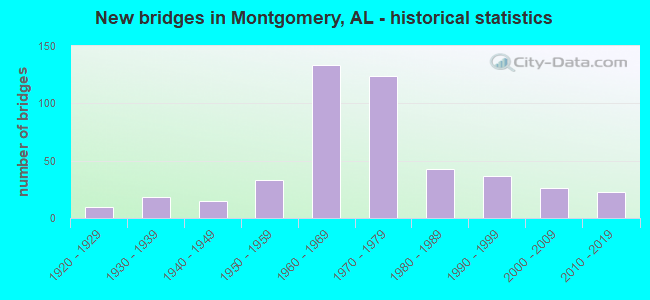
- New bridges - historical statistics
- 11910-1919
- 101920-1929
- 181930-1939
- 151940-1949
- 331950-1959
- 1331960-1969
- 1241970-1979
- 431980-1989
- 371990-1999
- 262000-2009
- 232010-2019
- 12020-2022
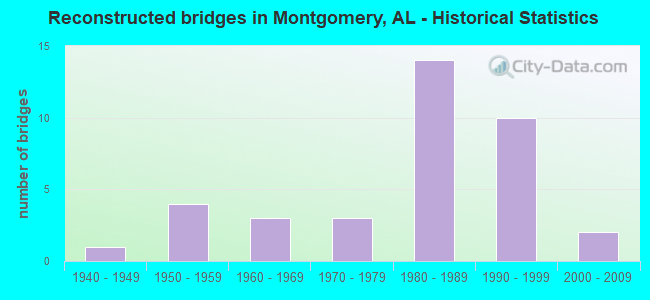
- Reconstructed bridges - Historical Statistics
- 11940-1949
- 41950-1959
- 31960-1969
- 31970-1979
- 141980-1989
- 101990-1999
- 22000-2009
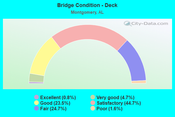
- Bridge Condition - Deck
- 0.8%Excellent
- 4.7%Very good
- 23.5%Good
- 44.7%Satisfactory
- 24.7%Fair
- 1.6%Poor
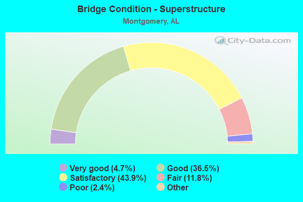
- Bridge Condition - Superstructure
- 4.7%Excellent
- 36.5%Very good
- 43.9%Good
- 11.8%Satisfactory
- 2.4%Fair
- 0.8%Poor
- 0.4%Serious
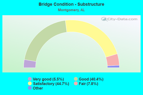
- Bridge Condition - Substructure
- 5.5%Excellent
- 40.4%Very good
- 44.7%Good
- 7.8%Satisfactory
- 1.6%Fair
- 0.8%Poor
- 0.4%Serious
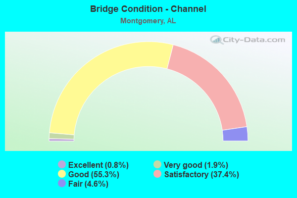
- Bridge Condition - Channel
- 0.8%Excellent
- 1.9%Very good
- 55.3%Good
- 37.4%Satisfactory
- 4.6%Fair
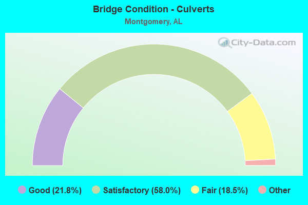
- Bridge Condition - Culverts
- 21.8%Excellent
- 58.0%Very good
- 18.5%Good
- 1.7%Satisfactory
- 18.5%Fair
Find on map >> Show street view
Structure Number: 11501, Location: 0.6 M E AL RIVER (Lat: 32.403333, Lng: -86.300000), Route carried "on" structure: Bypass State highway 152, Year Built: 1975, Status: Open, Structure Length: 65.35m (214.40ft), Average Daily Traffic: 16,745 (year 2013), Truck Traffic: 9%, Average Future Daily Traffic: 20,432 (year 2033), Design Load: HS 20, Features Intersected: L*N RR YARD * STREETS
Minimum Vertical Clearance: 30+ m (98+ ft), Kilometerpoint: 1.041, Lanes on structure: 2, Lanes under structure: 4, Base Highway Network: Yes, Owner: State Highway Agency, Approaching Roadway Width: 12.2m (40.0ft), Skew: 10 degrees, Material/Design: Steel, Design/Construction: Stringer/Multi-beam, Number Of Spans In Main Unit: 3, Number Of Approach Spans: 21, Length of Maximum Span: 39.3m (128.9ft), Curb-To-Curb Width: 11.9m (39.0ft), Out-to-Out Width: 13.0m (42.7ft)
Condition: Deck: Fair, Superstructure: Satisfactory, Substructure: Satisfactory, Operating Rating: 50.8 metric tons, Method Used To Determine Operating Rating: Load Factor (LF), Inventory Rating: 30.5 metric tons, Method Used To Determine Inventory Rating: Load Factor (LF), Structural Evaluation: Equal to present minimum criteria, Deck Geometry: Better than present minimum criteria, Underclear: High priority of corrective action, Approach Roadway Alignment: Better than present minimum criteria, Length Of Structure Improvement: 65.35m (214.40ft), Designated Inspection Frequency: Every 24 months, Inspection Date: September 2021, Bridge Improvement Cost: $18,820,000, Roadway Improvement Cost: $1,882,000, Total Project Cost: $20,702,000 ( Estimate for 2022), Deck Structure Type: Concrete Cast-file-Place
Find on map >> Show street view
Structure Number: 11502, Location: 0.6 M.E.AL RIVER (Lat: 32.403333, Lng: -86.300000), Route carried "on" structure: Bypass State highway 152, Year Built: 1975, Status: Open, Structure Length: 64.98m (213.19ft), Average Daily Traffic: 16,745 (year 2013), Truck Traffic: 9%, Average Future Daily Traffic: 20,432 (year 2033), Design Load: HS 20, Features Intersected: L*N RR YARD * STREETS
Minimum Vertical Clearance: 30+ m (98+ ft), Kilometerpoint: 1.041, Lanes on structure: 2, Lanes under structure: 4, Base Highway Network: Yes, Owner: State Highway Agency, Approaching Roadway Width: 12.2m (40.0ft), Skew: 10 degrees, Material/Design: Steel, Design/Construction: Stringer/Multi-beam, Number Of Spans In Main Unit: 4, Number Of Approach Spans: 21, Length of Maximum Span: 41.5m (136.2ft), Curb-To-Curb Width: 11.9m (39.0ft), Out-to-Out Width: 13.0m (42.7ft)
Condition: Deck: Fair, Superstructure: Satisfactory, Substructure: Satisfactory, Operating Rating: 52.0 metric tons, Method Used To Determine Operating Rating: Load Factor (LF), Inventory Rating: 31.1 metric tons, Method Used To Determine Inventory Rating: Load Factor (LF), Structural Evaluation: Equal to present minimum criteria, Deck Geometry: Better than present minimum criteria, Underclear: High priority of corrective action, Approach Roadway Alignment: Better than present minimum criteria, Length Of Structure Improvement: 64.98m (213.19ft), Designated Inspection Frequency: Every 24 months, Inspection Date: September 2021, Bridge Improvement Cost: $18,714,000, Roadway Improvement Cost: $1,871,000, Total Project Cost: $20,585,000 ( Estimate for 2022), Deck Structure Type: Concrete Cast-file-Place
Find on map >> Show street view
Structure Number: 11513, Location: 0.1 MI N OF MOBILE HWY (Lat: 32.347733, Lng: -86.340922), Route carried "on" structure: City street , Year Built: 1975, Status: Open, Structure Length: 5.00m (16.40ft), Average Daily Traffic: 8,470 (year 1988), Truck Traffic: 2%, Average Future Daily Traffic: 11,909 (year 2038), Design Load: HS 20, Features Intersected: L*N RR, Facility Carried by Structure: AIR BASE BLVD
Minimum Vertical Clearance: 30+ m (98+ ft), Kilometerpoint: 0.100, Lanes on structure: 3, Owner: City or Municipal Highway Agency, Approaching Roadway Width: 14.0m (45.9ft), Skew: 10 degrees, Material/Design: Steel, Design/Construction: Stringer/Multi-beam, Number Of Spans In Main Unit: 3, Length of Maximum Span: 18.3m (60.0ft), Curb or Sidewalk Widths: Left: 0.0m, Right: 1.5m (4.9ft), Curb-To-Curb Width: 14.8m (48.6ft), Out-to-Out Width: 15.3m (50.2ft)
Condition: Deck: Satisfactory, Superstructure: Satisfactory, Substructure: Satisfactory, Operating Rating: 62.0 metric tons, Method Used To Determine Operating Rating: Load Factor (LF), Inventory Rating: 37.1 metric tons, Method Used To Determine Inventory Rating: Load Factor (LF), Structural Evaluation: Equal to present minimum criteria, Deck Geometry: Equal to present minimum criteria, Underclear: Superior to present desirable criteria, Approach Roadway Alignment: Equal to present minimum criteria, Length Of Structure Improvement: 6.02m (19.75ft), Designated Inspection Frequency: Every 24 months, Inspection Date: December 2020, Bridge Improvement Cost: $2,062,000, Roadway Improvement Cost: $206,000, Total Project Cost: $2,268,000 ( Estimate for 2022), Deck Structure Type: Concrete Cast-file-Place
Find on map >> Show street view
Structure Number: 11514, Location: 0.1 MI N OF MOBILE HWY (Lat: 32.347939, Lng: -86.340778), Route carried "on" structure: City street , Year Built: 1975, Status: Open, Structure Length: 5.00m (16.40ft), Average Daily Traffic: 8,470 (year 1988), Truck Traffic: 2%, Average Future Daily Traffic: 11,909 (year 2038), Design Load: HS 20, Features Intersected: L*N RR, Facility Carried by Structure: AIR BASE BLVD
Minimum Vertical Clearance: 30+ m (98+ ft), Kilometerpoint: 0.100, Lanes on structure: 3, Owner: City or Municipal Highway Agency, Approaching Roadway Width: 14.0m (45.9ft), Skew: 10 degrees, Material/Design: Steel, Design/Construction: Stringer/Multi-beam, Number Of Spans In Main Unit: 3, Length of Maximum Span: 18.3m (60.0ft), Curb or Sidewalk Widths: Left: 0.0m, Right: 1.5m (4.9ft), Curb-To-Curb Width: 14.8m (48.6ft), Out-to-Out Width: 15.3m (50.2ft)
Condition: Deck: Satisfactory, Superstructure: Satisfactory, Substructure: Satisfactory, Operating Rating: 62.0 metric tons, Method Used To Determine Operating Rating: Load Factor (LF), Inventory Rating: 37.1 metric tons, Method Used To Determine Inventory Rating: Load Factor (LF), Structural Evaluation: Equal to present minimum criteria, Deck Geometry: Equal to present minimum criteria, Underclear: Superior to present desirable criteria, Approach Roadway Alignment: Equal to present minimum criteria, Length Of Structure Improvement: 6.02m (19.75ft), Designated Inspection Frequency: Every 24 months, Inspection Date: December 2020, Bridge Improvement Cost: $2,062,000, Roadway Improvement Cost: $206,000, Total Project Cost: $2,268,000 ( Estimate for 2022), Deck Structure Type: Concrete Cast-file-Place
Find on map >> Show street view
Structure Number: 11609, Location: 1.0 MI.S.OF SOU.BYPASS (Lat: 32.306639, Lng: -86.307606), Route carried "on" structure: US 331, Year Built: 1976, Status: Open, Structure Length: 23.74m (77.89ft), Average Daily Traffic: 3,615 (year 2013), Truck Traffic: 12%, Average Future Daily Traffic: 4,927 (year 2033), Design Load: HS 20, Features Intersected: CATOMA CREEK
Minimum Vertical Clearance: 30+ m (98+ ft), Kilometerpoint: 159.455, Lanes on structure: 2, Base Highway Network: Yes, Owner: State Highway Agency, Approaching Roadway Width: 10.4m (34.1ft), Skew: 10 degrees, Material/Design: Steel, Design/Construction: Stringer/Multi-beam, Number Of Spans In Main Unit: 3, Number Of Approach Spans: 17, Length of Maximum Span: 24.4m (80.1ft), Curb-To-Curb Width: 11.9m (39.0ft), Out-to-Out Width: 12.7m (41.7ft)
Condition: Deck: Satisfactory, Superstructure: Fair, Substructure: Satisfactory, Channel: Satisfactory, Operating Rating: 65.3 metric tons, Method Used To Determine Operating Rating: Load Factor (LF), Inventory Rating: 37.6 metric tons, Method Used To Determine Inventory Rating: Load Factor (LF), Structural Evaluation: Somewhat better than minimum adequacy, Deck Geometry: Equal to present minimum criteria, Waterway Adequacy: Superior to present desirable criteria, Approach Roadway Alignment: Better than present minimum criteria, Length Of Structure Improvement: 23.74m (77.89ft), Designated Inspection Frequency: Every 24 months, Inspection Date: September 2020, Bridge Improvement Cost: $6,674,000, Roadway Improvement Cost: $667,000, Total Project Cost: $7,341,000 ( Estimate for 2022), Deck Structure Type: Concrete Cast-file-Place
Find on map >> Show street view
Structure Number: 1161, Location: 1.0 MI.S.OF SOU BYPASS (Lat: 32.306639, Lng: -86.307347), Route carried "on" structure: US 331, Year Built: 1976, Status: Open, Structure Length: 23.74m (77.89ft), Average Daily Traffic: 3,615 (year 2013), Truck Traffic: 12%, Average Future Daily Traffic: 4,927 (year 2033), Design Load: HS 20, Features Intersected: CATOMA CREEK
Minimum Vertical Clearance: 30+ m (98+ ft), Kilometerpoint: 159.455, Lanes on structure: 2, Base Highway Network: Yes, Owner: State Highway Agency, Approaching Roadway Width: 10.4m (34.1ft), Skew: 10 degrees, Material/Design: Steel, Design/Construction: Stringer/Multi-beam, Number Of Spans In Main Unit: 3, Number Of Approach Spans: 17, Length of Maximum Span: 24.4m (80.1ft), Curb-To-Curb Width: 11.9m (39.0ft), Out-to-Out Width: 12.7m (41.7ft)
Condition: Deck: Satisfactory, Superstructure: Good, Substructure: Satisfactory, Channel: Satisfactory, Operating Rating: 65.3 metric tons, Method Used To Determine Operating Rating: Load Factor (LF), Inventory Rating: 37.6 metric tons, Method Used To Determine Inventory Rating: Load Factor (LF), Structural Evaluation: Equal to present minimum criteria, Deck Geometry: Equal to present minimum criteria, Waterway Adequacy: Superior to present desirable criteria, Approach Roadway Alignment: Better than present minimum criteria, Length Of Structure Improvement: 23.74m (77.89ft), Designated Inspection Frequency: Every 24 months, Inspection Date: September 2020, Bridge Improvement Cost: $6,674,000, Roadway Improvement Cost: $667,000, Total Project Cost: $7,341,000 ( Estimate for 2022), Deck Structure Type: Concrete Cast-file-Place
Find on map >> Show street view
Structure Number: 11611, Location: 0.6 MI.S.OF SOU BYPASS (Lat: 32.312294, Lng: -86.307686), Route carried "on" structure: US 331, Year Built: 1976, Status: Open, Structure Length: 6.22m (20.41ft), Average Daily Traffic: 3,615 (year 2013), Truck Traffic: 12%, Average Future Daily Traffic: 4,927 (year 2033), Design Load: HS 20, Features Intersected: CATOMA CREEK RELIEF#1
Minimum Vertical Clearance: 30+ m (98+ ft), Kilometerpoint: 160.086, Lanes on structure: 2, Base Highway Network: Yes, Owner: State Highway Agency, Approaching Roadway Width: 10.4m (34.1ft), Skew: 10 degrees, Material/Design: Prestressed concrete, Design/Construction: Stringer/Multi-beam, Number Of Spans In Main Unit: 6, Length of Maximum Span: 10.4m (34.1ft), Curb-To-Curb Width: 11.9m (39.0ft), Out-to-Out Width: 12.7m (41.7ft)
Condition: Deck: Satisfactory, Superstructure: Good, Substructure: Satisfactory, Channel: Good, Operating Rating: 45.9 metric tons, Method Used To Determine Operating Rating: Load Factor (LF), Inventory Rating: 27.5 metric tons, Method Used To Determine Inventory Rating: Load Factor (LF), Structural Evaluation: Equal to present minimum criteria, Deck Geometry: Equal to present minimum criteria, Waterway Adequacy: Superior to present desirable criteria, Approach Roadway Alignment: Better than present minimum criteria, Length Of Structure Improvement: 7.26m (23.82ft), Designated Inspection Frequency: Every 24 months, Inspection Date: April 2020, Bridge Improvement Cost: $2,041,000, Roadway Improvement Cost: $204,000, Total Project Cost: $2,245,000 ( Estimate for 2022), Deck Structure Type: Concrete Cast-file-Place
Find on map >> Show street view
Structure Number: 11612, Location: 0.6 MI.S.OF SOU BYPASS (Lat: 32.312297, Lng: -86.307444), Route carried "on" structure: US 331, Year Built: 1976, Status: Open, Structure Length: 6.22m (20.41ft), Average Daily Traffic: 3,615 (year 2013), Truck Traffic: 12%, Average Future Daily Traffic: 4,927 (year 2033), Design Load: HS 20, Features Intersected: CATOMA CREEK RELIEF#1
Minimum Vertical Clearance: 30+ m (98+ ft), Kilometerpoint: 160.086, Lanes on structure: 2, Base Highway Network: Yes, Owner: State Highway Agency, Approaching Roadway Width: 10.4m (34.1ft), Skew: 10 degrees, Material/Design: Prestressed concrete, Design/Construction: Stringer/Multi-beam, Number Of Spans In Main Unit: 6, Length of Maximum Span: 10.4m (34.1ft), Curb-To-Curb Width: 11.9m (39.0ft), Out-to-Out Width: 12.7m (41.7ft)
Condition: Deck: Satisfactory, Superstructure: Good, Substructure: Satisfactory, Channel: Good, Operating Rating: 45.9 metric tons, Method Used To Determine Operating Rating: Load Factor (LF), Inventory Rating: 27.5 metric tons, Method Used To Determine Inventory Rating: Load Factor (LF), Structural Evaluation: Equal to present minimum criteria, Deck Geometry: Equal to present minimum criteria, Waterway Adequacy: Superior to present desirable criteria, Approach Roadway Alignment: Better than present minimum criteria, Length Of Structure Improvement: 7.26m (23.82ft), Designated Inspection Frequency: Every 24 months, Inspection Date: April 2020, Bridge Improvement Cost: $2,041,000, Roadway Improvement Cost: $204,000, Total Project Cost: $2,245,000 ( Estimate for 2022), Deck Structure Type: Concrete Cast-file-Place
Find on map >> Show street view
Structure Number: 11613, Location: 0.3 MI.S.OF SOU.BYPASS (Lat: 32.317094, Lng: -86.307731), Route carried "on" structure: US 331, Year Built: 1976, Status: Open, Structure Length: 7.25m (23.79ft), Average Daily Traffic: 3,615 (year 2013), Truck Traffic: 12%, Average Future Daily Traffic: 4,927 (year 2033), Design Load: HS 20, Features Intersected: CATOMA CREEK RELIEF#2
Minimum Vertical Clearance: 30+ m (98+ ft), Kilometerpoint: 160.625, Lanes on structure: 2, Base Highway Network: Yes, Owner: State Highway Agency, Approaching Roadway Width: 10.4m (34.1ft), Skew: 10 degrees, Material/Design: Prestressed concrete, Design/Construction: Stringer/Multi-beam, Number Of Spans In Main Unit: 7, Length of Maximum Span: 10.4m (34.1ft), Curb-To-Curb Width: 11.9m (39.0ft), Out-to-Out Width: 12.7m (41.7ft)
Condition: Deck: Satisfactory, Superstructure: Good, Substructure: Good, Channel: Good, Operating Rating: 73.4 metric tons, Method Used To Determine Operating Rating: Load Factor (LF), Inventory Rating: 43.5 metric tons, Method Used To Determine Inventory Rating: Load Factor (LF), Structural Evaluation: Better than present minimum criteria, Deck Geometry: Equal to present minimum criteria, Waterway Adequacy: Superior to present desirable criteria, Approach Roadway Alignment: Better than present minimum criteria, Length Of Structure Improvement: 8.28m (27.17ft), Designated Inspection Frequency: Every 24 months, Inspection Date: April 2020, Bridge Improvement Cost: $2,328,000, Roadway Improvement Cost: $233,000, Total Project Cost: $2,561,000 ( Estimate for 2022), Deck Structure Type: Concrete Cast-file-Place
Find on map >> Show street view
Structure Number: 11614, Location: 0.3 MI.S.OF SOU.BYPASS (Lat: 32.317100, Lng: -86.307528), Route carried "on" structure: US 331, Year Built: 1976, Status: Open, Structure Length: 7.25m (23.79ft), Average Daily Traffic: 3,615 (year 2013), Truck Traffic: 12%, Average Future Daily Traffic: 4,927 (year 2033), Design Load: HS 20, Features Intersected: CATOMA CREEK RELIEF#2
Minimum Vertical Clearance: 30+ m (98+ ft), Kilometerpoint: 160.625, Lanes on structure: 2, Base Highway Network: Yes, Owner: State Highway Agency, Approaching Roadway Width: 10.4m (34.1ft), Skew: 10 degrees, Material/Design: Prestressed concrete, Design/Construction: Stringer/Multi-beam, Number Of Spans In Main Unit: 7, Length of Maximum Span: 10.4m (34.1ft), Curb-To-Curb Width: 11.9m (39.0ft), Out-to-Out Width: 12.7m (41.7ft)
Condition: Deck: Satisfactory, Superstructure: Good, Substructure: Good, Channel: Good, Operating Rating: 58.8 metric tons, Method Used To Determine Operating Rating: Load Factor (LF), Inventory Rating: 34.1 metric tons, Method Used To Determine Inventory Rating: Load Factor (LF), Structural Evaluation: Better than present minimum criteria, Deck Geometry: Equal to present minimum criteria, Waterway Adequacy: Superior to present desirable criteria, Approach Roadway Alignment: Better than present minimum criteria, Length Of Structure Improvement: 8.28m (27.17ft), Designated Inspection Frequency: Every 24 months, Inspection Date: April 2020, Bridge Improvement Cost: $2,328,000, Roadway Improvement Cost: $233,000, Total Project Cost: $2,561,000 ( Estimate for 2022), Deck Structure Type: Concrete Cast-file-Place
Find on map >> Show street view
Structure Number: 11621, Location: 75 FT W OF EASTDALE CIR (Lat: 32.385661, Lng: -86.209869), Route carried "on" structure: City street , Year Built: 1976, Status: Open, Structure Length: 0.67m (2.20ft), Average Daily Traffic: 7,000 (year 1992), Truck Traffic: 1%, Average Future Daily Traffic: 8,160 (year 2038), Design Load: H 15, Features Intersected: EASTDALE DITCH, Facility Carried by Structure: W MALL ENTRANCE
Minimum Vertical Clearance: 30+ m (98+ ft), Kilometerpoint: 0.100, Lanes on structure: 4, Owner: City or Municipal Highway Agency, Approaching Roadway Width: 15.2m (49.9ft), Skew: 20 degrees, Material/Design: Concrete continuous, Design/Construction: Culvert, Number Of Spans In Main Unit: 2, Length of Maximum Span: 3.0m (9.8ft), Out-to-Out Width: 7.7m (25.3ft)
Condition: Channel: Good, Culverts: Good, Operating Rating: 81.7 metric tons, Method Used To Determine Operating Rating: Load Factor (LF), Inventory Rating: 49.0 metric tons, Method Used To Determine Inventory Rating: Load Factor (LF), Structural Evaluation: Better than present minimum criteria, Waterway Adequacy: Better than present minimum criteria, Approach Roadway Alignment: Better than present minimum criteria, Length Of Structure Improvement: 1.30m (4.27ft), Designated Inspection Frequency: Every 24 months, Inspection Date: March 2020, Bridge Improvement Cost: $983,000, Roadway Improvement Cost: $98,000, Total Project Cost: $1,081,000 ( Estimate for 2022)
Find on map >> Show street view
Structure Number: 11736, Location: 0.17 MI N OF EASTERN BLVD (Lat: 32.329106, Lng: -86.242689), Route carried "on" structure: City street , Year Built: 1950, Year Reconstructed: 1977, Status: Open, Structure Length: 1.16m (3.81ft), Average Daily Traffic: 12,500 (year 1990), Truck Traffic: 3%, Average Future Daily Traffic: 13,766 (year 2038), Design Load: H 15, Features Intersected: BALDWIN SLOUGH, Facility Carried by Structure: MCGEHEE RD
Minimum Vertical Clearance: 30+ m (98+ ft), Kilometerpoint: 1.999, Lanes on structure: 4, Owner: City or Municipal Highway Agency, Approaching Roadway Width: 16.8m (55.1ft), Material/Design: Concrete, Design/Construction: Slab, Number Of Spans In Main Unit: 2, Number Of Approach Spans: 2, Length of Maximum Span: 4.6m (15.1ft), Curb-To-Curb Width: 16.8m (55.1ft), Out-to-Out Width: 17.2m (56.4ft)
Condition: Deck: Satisfactory, Superstructure: Satisfactory, Substructure: Satisfactory, Channel: Good, Operating Rating: 32.7 metric tons, Method Used To Determine Operating Rating: Field evaluation and documented engineering judgment, Inventory Rating: 23.6 metric tons, Method Used To Determine Inventory Rating: Field evaluation and documented engineering judgment, Structural Evaluation: Somewhat better than minimum adequacy, Deck Geometry: Somewhat better than minimum adequacy, Waterway Adequacy: Better than present minimum criteria, Approach Roadway Alignment: Better than present minimum criteria, Length Of Structure Improvement: 1.84m (6.04ft), Designated Inspection Frequency: Every 24 months, Inspection Date: June 2020, Bridge Improvement Cost: $705,000, Roadway Improvement Cost: $71,000, Total Project Cost: $776,000 ( Estimate for 2022), Deck Structure Type: Concrete Cast-file-Place
Find on map >> Show street view
Structure Number: 11918, Location: 1.3 MI E OF WOODLEY RD (Lat: 32.336450, Lng: -86.251906), Route carried "on" structure: City street , Year Built: 1960, Year Reconstructed: 1978, Status: Open, Structure Length: 1.16m (3.81ft), Average Daily Traffic: 10,500 (year 1990), Truck Traffic: 2%, Average Future Daily Traffic: 11,615 (year 2038), Design Load: H 15, Features Intersected: GLADLANE DITCH, Facility Carried by Structure: MCGEHEE RD
Minimum Vertical Clearance: 30+ m (98+ ft), Kilometerpoint: 1.299, Lanes on structure: 3, Owner: City or Municipal Highway Agency, Approaching Roadway Width: 11.6m (38.1ft), Material/Design: Concrete continuous, Design/Construction: Culvert, Number Of Spans In Main Unit: 2, Length of Maximum Span: 4.3m (14.1ft), Curb-To-Curb Width: 11.7m (38.4ft), Out-to-Out Width: 11.7m (38.4ft)
Condition: Channel: Good, Culverts: Satisfactory, Operating Rating: 88.9 metric tons, Method Used To Determine Operating Rating: Load Factor (LF), Inventory Rating: 69.8 metric tons, Method Used To Determine Inventory Rating: Load Factor (LF), Structural Evaluation: Equal to present minimum criteria, Deck Geometry: High priority of corrective action, Waterway Adequacy: Better than present minimum criteria, Approach Roadway Alignment: Better than present minimum criteria, Length Of Structure Improvement: 1.84m (6.04ft), Designated Inspection Frequency: Every 24 months, Inspection Date: April 2020, Bridge Improvement Cost: $954,000, Roadway Improvement Cost: $95,000, Total Project Cost: $1,049,000 ( Estimate for 2022)
Find on map >> Show street view
Structure Number: 11999, Location: 250 FT E OF CAROLVILLA DR (Lat: 32.380439, Lng: -86.214256), Route carried "on" structure: City street , Year Built: 1978, Status: Open, Structure Length: 1.04m (3.41ft), Average Daily Traffic: 1,200 (year 1992), Truck Traffic: 1%, Average Future Daily Traffic: 1,530 (year 2038), Design Load: H 15, Features Intersected: HOLY WATER CREEK, Facility Carried by Structure: MASON AVE
Minimum Vertical Clearance: 30+ m (98+ ft), Kilometerpoint: 0.100, Lanes on structure: 2, Owner: City or Municipal Highway Agency, Approaching Roadway Width: 9.4m (30.8ft), Material/Design: Concrete, Design/Construction: Channel Beam, Number Of Spans In Main Unit: 1, Length of Maximum Span: 10.4m (34.1ft), Curb or Sidewalk Widths: Left: 0.0m, Right: 2.1m (6.9ft), Curb-To-Curb Width: 9.6m (31.5ft), Out-to-Out Width: 12.4m (40.7ft)
Condition: Deck: Satisfactory, Superstructure: Good, Substructure: Good, Channel: Good, Operating Rating: 43.5 metric tons, Method Used To Determine Operating Rating: Field evaluation and documented engineering judgment, Inventory Rating: 32.7 metric tons, Method Used To Determine Inventory Rating: Field evaluation and documented engineering judgment, Structural Evaluation: Better than present minimum criteria, Deck Geometry: Somewhat better than minimum adequacy, Waterway Adequacy: Better than present minimum criteria, Approach Roadway Alignment: Better than present minimum criteria, Length Of Structure Improvement: 1.71m (5.61ft), Designated Inspection Frequency: Every 24 months, Inspection Date: March 2020, Bridge Improvement Cost: $470,000, Roadway Improvement Cost: $47,000, Total Project Cost: $517,000 ( Estimate for 2022), Deck Structure Type: Concrete Precast Panels, Wearing Surface/Protective System: Wearing Surface: Bituminous
Find on map >> Show street view
Structure Number: 12001, Location: 50 FT N OF BETH MANOR DR (Lat: 32.365481, Lng: -86.244178), Route carried "on" structure: City street , Year Built: 1978, Status: Open, Structure Length: 1.04m (3.41ft), Average Daily Traffic: 9,000 (year 1992), Truck Traffic: 1%, Average Future Daily Traffic: 10,201 (year 2038), Design Load: H 15, Features Intersected: DRAINAGE DITCH, Facility Carried by Structure: PERRY HILL RD
Minimum Vertical Clearance: 30+ m (98+ ft), Kilometerpoint: 0.999, Lanes on structure: 3, Owner: City or Municipal Highway Agency, Approaching Roadway Width: 11.6m (38.1ft), Material/Design: Concrete, Design/Construction: Channel Beam, Number Of Spans In Main Unit: 1, Length of Maximum Span: 10.4m (34.1ft), Curb-To-Curb Width: 13.4m (44.0ft), Out-to-Out Width: 21.2m (69.6ft)
Condition: Deck: Satisfactory, Superstructure: Satisfactory, Substructure: Satisfactory, Channel: Satisfactory, Operating Rating: 54.4 metric tons, Method Used To Determine Operating Rating: Load Factor (LF), Inventory Rating: 30.9 metric tons, Method Used To Determine Inventory Rating: Load Factor (LF), Structural Evaluation: Equal to present minimum criteria, Deck Geometry: Somewhat better than minimum adequacy, Waterway Adequacy: Better than present minimum criteria, Approach Roadway Alignment: Better than present minimum criteria, Length Of Structure Improvement: 1.71m (5.61ft), Designated Inspection Frequency: Every 24 months, Inspection Date: July 2020, Bridge Improvement Cost: $810,000, Roadway Improvement Cost: $81,000, Total Project Cost: $891,000 ( Estimate for 2022), Deck Structure Type: Concrete Precast Panels, Wearing Surface/Protective System: Wearing Surface: Bituminous
Find on map >> Show street view
Structure Number: 12032, Location: 200FT W OF KINGSBURY DR (Lat: 32.338067, Lng: -86.239908), Route carried "on" structure: City street , Year Built: 1978, Status: Open, Structure Length: 0.76m (2.49ft), Average Daily Traffic: 125 (year 1990), Truck Traffic: 1%, Average Future Daily Traffic: 153 (year 2038), Design Load: H 15, Features Intersected: BALDWIN SLOUGH, Facility Carried by Structure: LIZTAME DR
Minimum Vertical Clearance: 30+ m (98+ ft), Kilometerpoint: 0.100, Lanes on structure: 2, Owner: City or Municipal Highway Agency, Approaching Roadway Width: 12.2m (40.0ft), Material/Design: Concrete continuous, Design/Construction: Culvert, Number Of Spans In Main Unit: 2, Length of Maximum Span: 3.7m (12.1ft), Curb or Sidewalk Widths: Left: 1.5m (4.9ft), Right: 0.0m, Curb-To-Curb Width: 9.3m (30.5ft), Out-to-Out Width: 16.0m (52.5ft)
Condition: Channel: Good, Culverts: Good, Operating Rating: 47.5 metric tons, Method Used To Determine Operating Rating: Load Factor (LF), Inventory Rating: 28.6 metric tons, Method Used To Determine Inventory Rating: Load Factor (LF), Structural Evaluation: Better than present minimum criteria, Deck Geometry: Equal to present minimum criteria, Waterway Adequacy: Better than present minimum criteria, Approach Roadway Alignment: Better than present minimum criteria, Length Of Structure Improvement: 1.41m (4.63ft), Designated Inspection Frequency: Every 24 months, Inspection Date: April 2020, Bridge Improvement Cost: $423,000, Roadway Improvement Cost: $42,000, Total Project Cost: $465,000 ( Estimate for 2022)
Find on map >> Show street view
Structure Number: 12156, Location: 0.25 MI N OF KNOLLWOOD DR (Lat: 32.316403, Lng: -86.260917), Route carried "on" structure: City street , Year Built: 1979, Status: Open, Structure Length: 3.23m (10.60ft), Average Daily Traffic: 5,000 (year 1992), Truck Traffic: 1%, Average Future Daily Traffic: 6,120 (year 2038), Design Load: HS 20, Features Intersected: BALDWIN SLOUGH, Facility Carried by Structure: WOODLEY RD
Minimum Vertical Clearance: 30+ m (98+ ft), Kilometerpoint: 0.999, Lanes on structure: 2, Owner: City or Municipal Highway Agency, Approaching Roadway Width: 13.4m (44.0ft), Material/Design: Concrete continuous, Design/Construction: Culvert, Number Of Spans In Main Unit: 7, Length of Maximum Span: 3.7m (12.1ft), Curb or Sidewalk Widths: Left: 1.5m (4.9ft), Right: 0.0m
Condition: Channel: Satisfactory, Culverts: Satisfactory, Operating Rating: 40.8 metric tons, Method Used To Determine Operating Rating: Load Factor (LF), Inventory Rating: 24.4 metric tons, Method Used To Determine Inventory Rating: Load Factor (LF), Structural Evaluation: Equal to present minimum criteria, Waterway Adequacy: Better than present minimum criteria, Approach Roadway Alignment: Better than present minimum criteria, Length Of Structure Improvement: 4.10m (13.45ft), Designated Inspection Frequency: Every 24 months, Inspection Date: June 2020, Bridge Improvement Cost: $2,225,000, Roadway Improvement Cost: $223,000, Total Project Cost: $2,448,000 ( Estimate for 2022)
Find on map >> Show street view
Structure Number: 12168, Location: 0.2 MI E OF HALL ST (Lat: 32.374750, Lng: -86.288306), Route carried "on" structure: City street , Year Built: 1979, Status: Open, Structure Length: 2.93m (9.61ft), Average Daily Traffic: 6,500 (year 1991), Truck Traffic: 1%, Average Future Daily Traffic: 7,575 (year 2038), Design Load: HS 20, Features Intersected: C.OF GA.RR, Facility Carried by Structure: ADAMS AVE
Minimum Vertical Clearance: 30+ m (98+ ft), Kilometerpoint: 1.099, Lanes on structure: 2, Owner: City or Municipal Highway Agency, Approaching Roadway Width: 8.5m (27.9ft), Skew: 2 degrees, Material/Design: Steel continuous, Design/Construction: Stringer/Multi-beam, Number Of Spans In Main Unit: 1, Length of Maximum Span: 29.3m (96.1ft), Curb or Sidewalk Widths: Left: 1.5m (4.9ft), Right: 1.5m (4.9ft), Curb-To-Curb Width: 8.5m (27.9ft), Out-to-Out Width: 13.6m (44.6ft)
Condition: Deck: Satisfactory, Superstructure: Satisfactory, Substructure: Satisfactory, Operating Rating: 49.2 metric tons, Method Used To Determine Operating Rating: Load Factor (LF), Inventory Rating: 29.4 metric tons, Method Used To Determine Inventory Rating: Load Factor (LF), Structural Evaluation: Equal to present minimum criteria, Deck Geometry: High priority of replacement, Approach Roadway Alignment: Equal to present minimum criteria, Length Of Structure Improvement: 3.84m (12.60ft), Designated Inspection Frequency: Every 24 months, Inspection Date: November 2020, Bridge Improvement Cost: $1,158,000, Roadway Improvement Cost: $116,000, Total Project Cost: $1,274,000 ( Estimate for 2022), Deck Structure Type: Concrete Cast-file-Place
Find on map >> Show street view
Structure Number: 12379, Location: 0.8 MI N OF AVON RD (Lat: 32.394069, Lng: -86.219781), Route carried "on" structure: City street , Year Built: 1980, Status: Open, Structure Length: 0.67m (2.20ft), Average Daily Traffic: 300 (year 1992), Truck Traffic: 1%, Average Future Daily Traffic: 408 (year 2038), Design Load: H 15, Features Intersected: WARES FERRY DITCH, Facility Carried by Structure: HILDA DR
Minimum Vertical Clearance: 30+ m (98+ ft), Kilometerpoint: 0.000, Lanes on structure: 2, Owner: City or Municipal Highway Agency, Approaching Roadway Width: 15.5m (50.9ft), Material/Design: Concrete continuous, Design/Construction: Culvert, Number Of Spans In Main Unit: 2, Length of Maximum Span: 3.0m (9.8ft)
Condition: Channel: Good, Culverts: Satisfactory, Operating Rating: 84.6 metric tons, Method Used To Determine Operating Rating: Load Factor (LF), Inventory Rating: 50.8 metric tons, Method Used To Determine Inventory Rating: Load Factor (LF), Structural Evaluation: Equal to present minimum criteria, Waterway Adequacy: Better than present minimum criteria, Approach Roadway Alignment: Better than present minimum criteria, Length Of Structure Improvement: 1.30m (4.27ft), Designated Inspection Frequency: Every 24 months, Inspection Date: August 2020, Bridge Improvement Cost: $390,000, Roadway Improvement Cost: $39,000, Total Project Cost: $429,000 ( Estimate for 2022)
Find on map >> Show street view
Structure Number: 12403, Location: 200 FT E OF SEMMES DR (Lat: 32.341225, Lng: -86.238383), Route carried "on" structure: City street , Year Built: 1980, Status: Open, Structure Length: 0.76m (2.49ft), Average Daily Traffic: 125 (year 1990), Truck Traffic: 1%, Average Future Daily Traffic: 126 (year 2038), Design Load: H 15, Features Intersected: BALDWIN SLOUGH, Facility Carried by Structure: SHAMROCK LN
Minimum Vertical Clearance: 30+ m (98+ ft), Kilometerpoint: 0.000, Lanes on structure: 2, Owner: City or Municipal Highway Agency, Approaching Roadway Width: 12.2m (40.0ft), Material/Design: Concrete continuous, Design/Construction: Culvert, Number Of Spans In Main Unit: 2, Length of Maximum Span: 3.7m (12.1ft), Curb or Sidewalk Widths: Left: 1.5m (4.9ft), Right: 0.0m, Curb-To-Curb Width: 9.3m (30.5ft), Out-to-Out Width: 16.0m (52.5ft)
Condition: Channel: Good, Culverts: Good, Operating Rating: 45.4 metric tons, Method Used To Determine Operating Rating: Load Factor (LF), Inventory Rating: 27.2 metric tons, Method Used To Determine Inventory Rating: Load Factor (LF), Structural Evaluation: Equal to present minimum criteria, Deck Geometry: Equal to present minimum criteria, Waterway Adequacy: Better than present minimum criteria, Approach Roadway Alignment: Better than present minimum criteria, Length Of Structure Improvement: 1.41m (4.63ft), Designated Inspection Frequency: Every 24 months, Inspection Date: May 2020, Bridge Improvement Cost: $366,000, Roadway Improvement Cost: $37,000, Total Project Cost: $403,000 ( Estimate for 2022)
Find on map >> Show street view
Structure Number: 1243, Location: AUM INTERCHANGE (Lat: 32.360503, Lng: -86.171453), Route carried "on" structure: State highway 271, Year Built: 1980, Status: Open, Structure Length: 7.13m (23.39ft), Average Daily Traffic: 17,965 (year 2013), Truck Traffic: 4%, Average Future Daily Traffic: 21,704 (year 2033), Design Load: HS 20, Features Intersected: I85 NBL
Minimum Vertical Clearance: 30+ m (98+ ft), Kilometerpoint: 7.847, Lanes on structure: 3, Lanes under structure: 2, Owner: State Highway Agency, Approaching Roadway Width: 13.4m (44.0ft), Skew: 10 degrees, Material/Design: Steel continuous, Design/Construction: Stringer/Multi-beam, Number Of Spans In Main Unit: 3, Length of Maximum Span: 27.4m (89.9ft), Curb-To-Curb Width: 15.6m (51.2ft), Out-to-Out Width: 16.5m (54.1ft)
Condition: Deck: Fair, Superstructure: Satisfactory, Substructure: Good, Operating Rating: 56.6 metric tons, Method Used To Determine Operating Rating: Load Factor (LF), Inventory Rating: 33.8 metric tons, Method Used To Determine Inventory Rating: Load Factor (LF), Structural Evaluation: Equal to present minimum criteria, Deck Geometry: Equal to present minimum criteria, Underclear: Superior to present desirable criteria, Approach Roadway Alignment: Better than present minimum criteria, Length Of Structure Improvement: 8.16m (26.77ft), Designated Inspection Frequency: Every 24 months, Inspection Date: May 2020, Bridge Improvement Cost: $3,021,000, Roadway Improvement Cost: $302,000, Total Project Cost: $3,323,000 ( Estimate for 2022), Deck Structure Type: Concrete Cast-file-Place
Find on map >> Show street view
Structure Number: 12431, Location: AUM INTERCHANGE (Lat: 32.360500, Lng: -86.171150), Route carried "on" structure: State highway 271, Year Built: 1980, Status: Open, Structure Length: 7.13m (23.39ft), Average Daily Traffic: 17,965 (year 2013), Truck Traffic: 4%, Average Future Daily Traffic: 21,704 (year 2033), Design Load: HS 20, Features Intersected: I85 NBL
Minimum Vertical Clearance: 30+ m (98+ ft), Kilometerpoint: 7.847, Lanes on structure: 2, Lanes under structure: 2, Owner: State Highway Agency, Approaching Roadway Width: 13.4m (44.0ft), Skew: 10 degrees, Material/Design: Steel continuous, Design/Construction: Stringer/Multi-beam, Number Of Spans In Main Unit: 3, Length of Maximum Span: 27.4m (89.9ft), Curb-To-Curb Width: 11.9m (39.0ft), Out-to-Out Width: 12.8m (42.0ft)
Condition: Deck: Fair, Superstructure: Satisfactory, Substructure: Satisfactory, Operating Rating: 52.4 metric tons, Method Used To Determine Operating Rating: Load Factor (LF), Inventory Rating: 31.4 metric tons, Method Used To Determine Inventory Rating: Load Factor (LF), Structural Evaluation: Equal to present minimum criteria, Deck Geometry: Better than present minimum criteria, Underclear: Superior to present desirable criteria, Approach Roadway Alignment: Better than present minimum criteria, Length Of Structure Improvement: 8.16m (26.77ft), Designated Inspection Frequency: Every 24 months, Inspection Date: May 2020, Bridge Improvement Cost: $2,350,000, Roadway Improvement Cost: $235,000, Total Project Cost: $2,585,000 ( Estimate for 2022), Deck Structure Type: Concrete Cast-file-Place
Find on map >> Show street view
Structure Number: 12432, Location: AUM INTERCHANGE (Lat: 32.362228, Lng: -86.171508), Route carried "on" structure: State highway 271, Year Built: 1980, Status: Open, Structure Length: 7.13m (23.39ft), Average Daily Traffic: 17,965 (year 2013), Truck Traffic: 4%, Average Future Daily Traffic: 21,704 (year 2033), Design Load: HS 20, Features Intersected: I85 SBL
Minimum Vertical Clearance: 30+ m (98+ ft), Kilometerpoint: 7.958, Lanes on structure: 2, Lanes under structure: 2, Owner: State Highway Agency, Approaching Roadway Width: 13.4m (44.0ft), Skew: 10 degrees, Material/Design: Steel continuous, Design/Construction: Stringer/Multi-beam, Number Of Spans In Main Unit: 3, Length of Maximum Span: 27.4m (89.9ft), Curb-To-Curb Width: 11.9m (39.0ft), Out-to-Out Width: 12.8m (42.0ft)
Condition: Deck: Fair, Superstructure: Satisfactory, Substructure: Satisfactory, Operating Rating: 52.4 metric tons, Method Used To Determine Operating Rating: Load Factor (LF), Inventory Rating: 31.4 metric tons, Method Used To Determine Inventory Rating: Load Factor (LF), Structural Evaluation: Equal to present minimum criteria, Deck Geometry: Better than present minimum criteria, Underclear: Superior to present desirable criteria, Approach Roadway Alignment: Better than present minimum criteria, Length Of Structure Improvement: 8.16m (26.77ft), Designated Inspection Frequency: Every 24 months, Inspection Date: May 2020, Bridge Improvement Cost: $2,350,000, Roadway Improvement Cost: $235,000, Total Project Cost: $2,585,000 ( Estimate for 2022), Deck Structure Type: Concrete Cast-file-Place
Find on map >> Show street view
Structure Number: 12433, Location: AUM INTERCHANGE (Lat: 32.362267, Lng: -86.171164), Route carried "on" structure: State highway 271, Year Built: 1980, Status: Open, Structure Length: 7.13m (23.39ft), Average Daily Traffic: 17,965 (year 2013), Truck Traffic: 4%, Average Future Daily Traffic: 21,704 (year 2033), Design Load: HS 20, Features Intersected: I85 SBL
Minimum Vertical Clearance: 30+ m (98+ ft), Kilometerpoint: 7.958, Lanes on structure: 3, Lanes under structure: 2, Owner: State Highway Agency, Approaching Roadway Width: 13.4m (44.0ft), Skew: 10 degrees, Material/Design: Steel continuous, Design/Construction: Stringer/Multi-beam, Number Of Spans In Main Unit: 3, Length of Maximum Span: 27.4m (89.9ft), Curb-To-Curb Width: 15.6m (51.2ft), Out-to-Out Width: 16.5m (54.1ft)
Condition: Deck: Fair, Superstructure: Satisfactory, Substructure: Satisfactory, Operating Rating: 56.6 metric tons, Method Used To Determine Operating Rating: Load Factor (LF), Inventory Rating: 33.8 metric tons, Method Used To Determine Inventory Rating: Load Factor (LF), Structural Evaluation: Equal to present minimum criteria, Deck Geometry: Equal to present minimum criteria, Underclear: Superior to present desirable criteria, Approach Roadway Alignment: Better than present minimum criteria, Length Of Structure Improvement: 8.16m (26.77ft), Designated Inspection Frequency: Every 24 months, Inspection Date: May 2020, Bridge Improvement Cost: $3,021,000, Roadway Improvement Cost: $302,000, Total Project Cost: $3,323,000 ( Estimate for 2022), Deck Structure Type: Concrete Cast-file-Place
Find on map >> Show street view
Structure Number: 12749, Location: 24.2 MI N OF PIKE CO LINE (Lat: 32.284314, Lng: -86.222631), Route carried "on" structure: County highway 3, Year Built: 1982, Status: Open, Structure Length: 3.66m (12.01ft), Average Daily Traffic: 900 (year 1988), Truck Traffic: 1%, Average Future Daily Traffic: 1,500 (year 2041), Design Load: H 15, Features Intersected: DRAINAGE RELIEF, Facility Carried by Structure: WOODLEY ROAD
Minimum Vertical Clearance: 30+ m (98+ ft), Kilometerpoint: 0.010, Lanes on structure: 2, Owner: County Highway Agency, Approaching Roadway Width: 7.3m (24.0ft), Material/Design: Concrete, Design/Construction: Channel Beam, Number Of Spans In Main Unit: 1, Length of Maximum Span: 7.3m (24.0ft), Curb-To-Curb Width: 8.6m (28.2ft), Out-to-Out Width: 9.4m (30.8ft)
Condition: Deck: Very good, Superstructure: Good, Substructure: Very good, Channel: Good, Operating Rating: 49.4 metric tons, Method Used To Determine Operating Rating: Load Factor (LF), Inventory Rating: 29.7 metric tons, Method Used To Determine Inventory Rating: Load Factor (LF), Structural Evaluation: Better than present minimum criteria, Deck Geometry: Somewhat better than minimum adequacy, Waterway Adequacy: Better than present minimum criteria, Approach Roadway Alignment: Equal to present desirable criteria, Length Of Structure Improvement: 4.58m (15.03ft), Designated Inspection Frequency: Every 24 months, Inspection Date: August 2021, Bridge Improvement Cost: $942,000, Roadway Improvement Cost: $94,000, Total Project Cost: $1,036,000 ( Estimate for 2022), Deck Structure Type: Concrete Precast Panels, Wearing Surface/Protective System: Wearing Surface: Bituminous
Find on map >> Show street view
Structure Number: 12762, Location: E. BYPASS AND ATLANTA HWY (Lat: 32.381458, Lng: -86.210139), Route carried "on" structure: US 231, Year Built: 1982, Status: Open, Structure Length: 9.81m (32.19ft), Average Daily Traffic: 20,125 (year 2013), Truck Traffic: 4%, Average Future Daily Traffic: 27,427 (year 2033), Design Load: HS 20, Features Intersected: AL 108 AND SERVICE ROADS
Minimum Vertical Clearance: 30+ m (98+ ft), Kilometerpoint: 175.084, Lanes on structure: 3, Lanes under structure: 10, Base Highway Network: Yes, Owner: State Highway Agency, Approaching Roadway Width: 16.5m (54.1ft), Skew: 10 degrees, Material/Design: Steel continuous, Design/Construction: Stringer/Multi-beam, Number Of Spans In Main Unit: 4, Length of Maximum Span: 40.2m (131.9ft), Curb-To-Curb Width: 15.8m (51.8ft), Out-to-Out Width: 16.6m (54.5ft)
Condition: Deck: Satisfactory, Superstructure: Satisfactory, Substructure: Satisfactory, Operating Rating: 62.3 metric tons, Method Used To Determine Operating Rating: Load Factor (LF), Inventory Rating: 37.4 metric tons, Method Used To Determine Inventory Rating: Load Factor (LF), Structural Evaluation: Equal to present minimum criteria, Deck Geometry: Better than present minimum criteria, Underclear: Meets minimum limits, Approach Roadway Alignment: Better than present minimum criteria, Length Of Structure Improvement: 10.75m (35.27ft), Designated Inspection Frequency: Every 24 months, Inspection Date: April 2020, Bridge Improvement Cost: $3,980,000, Roadway Improvement Cost: $398,000, Total Project Cost: $4,378,000 ( Estimate for 2022), Deck Structure Type: Concrete Cast-file-Place
Find on map >> Show street view
Structure Number: 12763, Location: E.BYPASS AND ATLANTA HWY (Lat: 32.381483, Lng: -86.209967), Route carried "on" structure: US 231, Year Built: 1982, Status: Open, Structure Length: 9.81m (32.19ft), Average Daily Traffic: 20,125 (year 2013), Truck Traffic: 4%, Average Future Daily Traffic: 27,427 (year 2033), Design Load: HS 20, Features Intersected: AL 108 AND SERVICE ROADS
Minimum Vertical Clearance: 30+ m (98+ ft), Kilometerpoint: 175.089, Lanes on structure: 3, Lanes under structure: 10, Base Highway Network: Yes, Owner: State Highway Agency, Approaching Roadway Width: 16.5m (54.1ft), Skew: 10 degrees, Material/Design: Steel continuous, Design/Construction: Stringer/Multi-beam, Number Of Spans In Main Unit: 4, Length of Maximum Span: 40.2m (131.9ft), Curb-To-Curb Width: 15.8m (51.8ft), Out-to-Out Width: 16.6m (54.5ft)
Condition: Deck: Satisfactory, Superstructure: Satisfactory, Substructure: Satisfactory, Operating Rating: 62.3 metric tons, Method Used To Determine Operating Rating: Load Factor (LF), Inventory Rating: 37.4 metric tons, Method Used To Determine Inventory Rating: Load Factor (LF), Structural Evaluation: Equal to present minimum criteria, Deck Geometry: Better than present minimum criteria, Underclear: Meets minimum limits, Approach Roadway Alignment: Better than present minimum criteria, Length Of Structure Improvement: 10.75m (35.27ft), Designated Inspection Frequency: Every 24 months, Inspection Date: April 2020, Bridge Improvement Cost: $3,980,000, Roadway Improvement Cost: $398,000, Total Project Cost: $4,378,000 ( Estimate for 2022), Deck Structure Type: Concrete Cast-file-Place
Find on map >> Show street view
Structure Number: 1279, Location: 200 FT N OF FAUNSDALE DR (Lat: 32.391008, Lng: -86.233136), Route carried "on" structure: City street 37, Year Built: 1982, Status: Open, Structure Length: 0.61m (2.00ft), Average Daily Traffic: 75 (year 1992), Average Future Daily Traffic: 151 (year 2038), Design Load: H 15, Features Intersected: WARES FERRY DITCH, Facility Carried by Structure: THOUSAND OAKS DR
Minimum Vertical Clearance: 7.56m (24.80ft), Kilometerpoint: 0.200, Lanes on structure: 2, Owner: City or Municipal Highway Agency, Approaching Roadway Width: 9.1m (29.9ft), Material/Design: Concrete continuous, Design/Construction: Culvert, Number Of Spans In Main Unit: 2, Length of Maximum Span: 3.0m (9.8ft), Curb or Sidewalk Widths: Left: 0.0m, Right: 1.5m (4.9ft)
Condition: Channel: Good, Culverts: Satisfactory, Operating Rating: 88.9 metric tons, Method Used To Determine Operating Rating: Load Factor (LF), Inventory Rating: 59.6 metric tons, Method Used To Determine Inventory Rating: Load Factor (LF), Structural Evaluation: Equal to present minimum criteria, Waterway Adequacy: Equal to present minimum criteria, Approach Roadway Alignment: Better than present minimum criteria, Length Of Structure Improvement: 1.22m (4.00ft), Designated Inspection Frequency: Every 24 months, Inspection Date: October 2020, Bridge Improvement Cost: $458,000, Roadway Improvement Cost: $46,000, Total Project Cost: $504,000 ( Estimate for 2022)
Find on map >> Show street view
Structure Number: 12791, Location: 0.35 MI E OF DALRAIDA RD (Lat: 32.399400, Lng: -86.239600), Route carried "on" structure: City street 38, Year Built: 1982, Status: Open, Structure Length: 1.16m (3.81ft), Average Daily Traffic: 150 (year 1992), Truck Traffic: 1%, Average Future Daily Traffic: 255 (year 2038), Design Load: H 15, Features Intersected: WARES FERRY DITCH, Facility Carried by Structure: BEARDSLEY DR
Minimum Vertical Clearance: 30+ m (98+ ft), Kilometerpoint: 0.599, Lanes on structure: 2, Owner: City or Municipal Highway Agency, Approaching Roadway Width: 9.4m (30.8ft), Skew: 3 degrees, Material/Design: Concrete, Design/Construction: Channel Beam, Number Of Spans In Main Unit: 2, Length of Maximum Span: 5.8m (19.0ft), Curb or Sidewalk Widths: Left: 0.0m, Right: 2.1m (6.9ft), Curb-To-Curb Width: 9.3m (30.5ft), Out-to-Out Width: 11.7m (38.4ft)
Condition: Deck: Good, Superstructure: Good, Substructure: Satisfactory, Channel: Good, Operating Rating: 57.2 metric tons, Method Used To Determine Operating Rating: Load Factor (LF), Inventory Rating: 34.3 metric tons, Method Used To Determine Inventory Rating: Load Factor (LF), Structural Evaluation: Equal to present minimum criteria, Deck Geometry: Equal to present minimum criteria, Waterway Adequacy: Better than present minimum criteria, Approach Roadway Alignment: Better than present minimum criteria, Length Of Structure Improvement: 1.84m (6.04ft), Designated Inspection Frequency: Every 24 months, Inspection Date: May 2020, Bridge Improvement Cost: $479,000, Roadway Improvement Cost: $48,000, Total Project Cost: $527,000 ( Estimate for 2022), Deck Structure Type: Concrete Precast Panels
Find on map >> Show street view
Structure Number: 12795, Location: 0.05 MI W OF ZELDA RD (Lat: 32.362217, Lng: -86.266989), Route carried "on" structure: City street 42, Year Built: 1982, Status: Open, Structure Length: 1.58m (5.18ft), Average Daily Traffic: 200 (year 1992), Truck Traffic: 1%, Average Future Daily Traffic: 254 (year 2038), Design Load: H 20, Features Intersected: DRAINAGE DITCH, Facility Carried by Structure: GATSBY DR
Minimum Vertical Clearance: 30+ m (98+ ft), Kilometerpoint: 0.100, Lanes on structure: 2, Owner: City or Municipal Highway Agency, Approaching Roadway Width: 10.1m (33.1ft), Material/Design: Concrete continuous, Design/Construction: Culvert, Number Of Spans In Main Unit: 4, Length of Maximum Span: 3.0m (9.8ft), Curb or Sidewalk Widths: Left: 1.2m (3.9ft), Right: 0.0m
Condition: Channel: Good, Culverts: Good, Operating Rating: 48.9 metric tons, Method Used To Determine Operating Rating: Load Factor (LF), Inventory Rating: 29.3 metric tons, Method Used To Determine Inventory Rating: Load Factor (LF), Structural Evaluation: Better than present minimum criteria, Waterway Adequacy: Better than present minimum criteria, Approach Roadway Alignment: Better than present minimum criteria, Length Of Structure Improvement: 2.26m (7.41ft), Designated Inspection Frequency: Every 24 months, Inspection Date: July 2020, Bridge Improvement Cost: $1,711,000, Roadway Improvement Cost: $171,000, Total Project Cost: $1,882,000 ( Estimate for 2022)
Find on map >> Show street view
Structure Number: 13013, Location: 0.2 MI E OF ANN ST (Lat: 32.364075, Lng: -86.267742), Route carried "on" structure: City street 40, Year Built: 1983, Status: Open, Structure Length: 1.49m (4.89ft), Average Daily Traffic: 6,500 (year 1992), Truck Traffic: 1%, Average Future Daily Traffic: 8,080 (year 2038), Design Load: HS 20, Features Intersected: DRAINAGE DITCH, Facility Carried by Structure: ZELDA RD
Minimum Vertical Clearance: 30+ m (98+ ft), Kilometerpoint: 0.200, Lanes on structure: 4, Owner: City or Municipal Highway Agency, Approaching Roadway Width: 23.2m (76.1ft), Material/Design: Concrete continuous, Design/Construction: Culvert, Number Of Spans In Main Unit: 4, Length of Maximum Span: 3.0m (9.8ft), Curb or Sidewalk Widths: Left: 1.5m (4.9ft), Right: 0.0m
Condition: Channel: Good, Culverts: Satisfactory, Operating Rating: 63.2 metric tons, Method Used To Determine Operating Rating: Load Factor (LF), Inventory Rating: 37.8 metric tons, Method Used To Determine Inventory Rating: Load Factor (LF), Structural Evaluation: Equal to present minimum criteria, Waterway Adequacy: Better than present minimum criteria, Approach Roadway Alignment: Better than present minimum criteria, Length Of Structure Improvement: 2.17m (7.12ft), Designated Inspection Frequency: Every 24 months, Inspection Date: July 2020, Bridge Improvement Cost: $952,000, Roadway Improvement Cost: $95,000, Total Project Cost: $1,047,000 ( Estimate for 2022)
Find on map >> Show street view
Structure Number: 13014, Location: BEHIND STARBUCKS (Lat: 32.353800, Lng: -86.264600), Route carried "on" structure: City street 40, Year Built: 1983, Status: Open, Structure Length: 0.73m (2.40ft), Average Daily Traffic: 6,500 (year 1992), Truck Traffic: 1%, Average Future Daily Traffic: 8,080 (year 2038), Design Load: H 20, Features Intersected: THREE MILE BRANCH, Facility Carried by Structure: ZELDA ROAD
Minimum Vertical Clearance: 30+ m (98+ ft), Kilometerpoint: 1.099, Lanes on structure: 4, Owner: City or Municipal Highway Agency, Approaching Roadway Width: 22.9m (75.1ft), Skew: 4 degrees, Material/Design: Concrete continuous, Design/Construction: Culvert, Number Of Spans In Main Unit: 2, Length of Maximum Span: 2.4m (7.9ft), Curb or Sidewalk Widths: Left: 0.0m, Right: 1.5m (4.9ft)
Condition: Channel: Satisfactory, Culverts: Satisfactory, Operating Rating: 77.7 metric tons, Method Used To Determine Operating Rating: Load Factor (LF), Inventory Rating: 46.4 metric tons, Method Used To Determine Inventory Rating: Load Factor (LF), Structural Evaluation: Equal to present minimum criteria, Waterway Adequacy: Better than present minimum criteria, Approach Roadway Alignment: Better than present minimum criteria, Length Of Structure Improvement: 1.38m (4.53ft), Designated Inspection Frequency: Every 24 months, Inspection Date: September 2020, Bridge Improvement Cost: $1,304,000, Roadway Improvement Cost: $130,000, Total Project Cost: $1,434,000 ( Estimate for 2022)
Find on map >> Show street view
Structure Number: 13051, Location: 0.6 MI E OF EASTERN BLVD (Lat: 32.341900, Lng: -86.214100), Route carried "on" structure: City street 110, Year Built: 1983, Status: Open, Structure Length: 0.73m (2.40ft), Average Daily Traffic: 16,540 (year 1990), Truck Traffic: 4%, Average Future Daily Traffic: 39,207 (year 2038), Design Load: HS 20, Features Intersected: STREAM, Facility Carried by Structure: VAUGHN RD
Minimum Vertical Clearance: 30+ m (98+ ft), Kilometerpoint: 6.199, Lanes on structure: 5, Owner: City or Municipal Highway Agency, Approaching Roadway Width: 18.3m (60.0ft), Material/Design: Concrete continuous, Design/Construction: Culvert, Number Of Spans In Main Unit: 2, Length of Maximum Span: 3.0m (9.8ft)
Condition: Channel: Satisfactory, Culverts: Satisfactory, Operating Rating: 61.4 metric tons, Method Used To Determine Operating Rating: Load Factor (LF), Inventory Rating: 36.8 metric tons, Method Used To Determine Inventory Rating: Load Factor (LF), Structural Evaluation: Equal to present minimum criteria, Waterway Adequacy: Equal to present minimum criteria, Approach Roadway Alignment: Better than present minimum criteria, Length Of Structure Improvement: 1.38m (4.53ft), Designated Inspection Frequency: Every 24 months, Inspection Date: September 2020, Bridge Improvement Cost: $1,288,000, Roadway Improvement Cost: $129,000, Total Project Cost: $1,417,000 ( Estimate for 2022)
Find on map >> Show street view
Structure Number: 13234, Location: 0.3 MI S OF DAY ST (Lat: 32.365183, Lng: -86.340086), Route carried "on" structure: City street 5, Year Built: 1984, Status: Open, Structure Length: 0.62m (2.03ft), Average Daily Traffic: 200 (year 1990), Truck Traffic: 1%, Average Future Daily Traffic: 253 (year 2040), Design Load: H 20, Features Intersected: WEST END DRAINAGE DITCH, Facility Carried by Structure: DAY STREET RD
Minimum Vertical Clearance: 30+ m (98+ ft), Kilometerpoint: 0.499, Lanes on structure: 2, Owner: City or Municipal Highway Agency, Approaching Roadway Width: 12.8m (42.0ft), Skew: 3 degrees, Material/Design: Concrete continuous, Design/Construction: Culvert, Number Of Spans In Main Unit: 2, Length of Maximum Span: 3.0m (9.8ft)
Condition: Channel: Satisfactory, Culverts: Good, Operating Rating: 66.7 metric tons, Method Used To Determine Operating Rating: Load Factor (LF), Inventory Rating: 40.0 metric tons, Method Used To Determine Inventory Rating: Load Factor (LF), Structural Evaluation: Better than present minimum criteria, Waterway Adequacy: Equal to present minimum criteria, Approach Roadway Alignment: Better than present minimum criteria, Length Of Structure Improvement: 1.24m (4.07ft), Designated Inspection Frequency: Every 24 months, Inspection Date: Febuary 2022, Bridge Improvement Cost: $388,000, Roadway Improvement Cost: $39,000, Total Project Cost: $427,000 ( Estimate for 2022)
Find on map >> Show street view
Structure Number: 13272, Location: 250 FT E OF COLISEUM BLVD (Lat: 32.388892, Lng: -86.256558), Route carried "on" structure: City street 12, Year Built: 1984, Status: Open, Structure Length: 2.07m (6.79ft), Average Daily Traffic: 2,500 (year 1992), Truck Traffic: 1%, Average Future Daily Traffic: 3,060 (year 2038), Design Load: HS 20, Features Intersected: THREE MI BRANCH, Facility Carried by Structure: PELZER AVE
Minimum Vertical Clearance: 30+ m (98+ ft), Kilometerpoint: 0.999, Lanes on structure: 2, Owner: City or Municipal Highway Agency, Approaching Roadway Width: 9.4m (30.8ft), Material/Design: Concrete, Design/Construction: Channel Beam, Number Of Spans In Main Unit: 2, Length of Maximum Span: 10.4m (34.1ft), Curb or Sidewalk Widths: Left: 2.4m (7.9ft), Right: 2.4m (7.9ft), Curb-To-Curb Width: 9.7m (31.8ft), Out-to-Out Width: 15.2m (49.9ft)
Condition: Deck: Satisfactory, Superstructure: Satisfactory, Substructure: Satisfactory, Channel: Good, Operating Rating: 65.7 metric tons, Method Used To Determine Operating Rating: Load Factor (LF), Inventory Rating: 39.5 metric tons, Method Used To Determine Inventory Rating: Load Factor (LF), Structural Evaluation: Equal to present minimum criteria, Deck Geometry: Meets minimum limits, Waterway Adequacy: Better than present minimum criteria, Approach Roadway Alignment: Better than present minimum criteria, Length Of Structure Improvement: 2.84m (9.32ft), Designated Inspection Frequency: Every 24 months, Inspection Date: April 2020, Bridge Improvement Cost: $953,000, Roadway Improvement Cost: $95,000, Total Project Cost: $1,048,000 ( Estimate for 2022), Deck Structure Type: Concrete Precast Panels
Find on map >> Show street view
Structure Number: 13283, Location: 1.4 MI S VIG. LP. RD (Lat: 32.282783, Lng: -86.221486), Route carried "on" structure: County highway , Year Built: 1984, Status: Open, Structure Length: 5.18m (16.99ft), Average Daily Traffic: 5,000 (year 1991), Truck Traffic: 1%, Average Future Daily Traffic: 10,000 (year 2038), Design Load: HS 20, Features Intersected: DRAINAGE RELIEF, Facility Carried by Structure: WOODLEY RD
Minimum Vertical Clearance: 30+ m (98+ ft), Kilometerpoint: 0.010, Lanes on structure: 2, Owner: City or Municipal Highway Agency, Approaching Roadway Width: 7.3m (24.0ft), Material/Design: Concrete, Design/Construction: Channel Beam, Number Of Spans In Main Unit: 5, Length of Maximum Span: 10.4m (34.1ft), Curb-To-Curb Width: 8.5m (27.9ft), Out-to-Out Width: 9.3m (30.5ft)
Condition: Deck: Satisfactory, Superstructure: Satisfactory, Substructure: Satisfactory, Channel: Good, Operating Rating: 66.5 metric tons, Method Used To Determine Operating Rating: Load Factor (LF), Inventory Rating: 39.9 metric tons, Method Used To Determine Inventory Rating: Load Factor (LF), Structural Evaluation: Equal to present minimum criteria, Deck Geometry: Meets minimum limits, Waterway Adequacy: Better than present minimum criteria, Approach Roadway Alignment: Better than present minimum criteria, Length Of Structure Improvement: 6.20m (20.34ft), Designated Inspection Frequency: Every 24 months, Inspection Date: Febuary 2022, Bridge Improvement Cost: $1,276,000, Roadway Improvement Cost: $128,000, Total Project Cost: $1,404,000 ( Estimate for 2022), Deck Structure Type: Concrete Precast Panels, Wearing Surface/Protective System: Wearing Surface: Bituminous
Find on map >> Show street view
Structure Number: 13284, Location: 1.7 MI S OF VIG. LP. RD (Lat: 32.278511, Lng: -86.219222), Route carried "on" structure: County highway , Year Built: 1984, Status: Open, Structure Length: 9.33m (30.61ft), Average Daily Traffic: 5,000 (year 1991), Truck Traffic: 1%, Average Future Daily Traffic: 10,000 (year 2038), Design Load: HS 20, Features Intersected: BARNES SLOUGH, Facility Carried by Structure: WOODLEY RD
Minimum Vertical Clearance: 30+ m (98+ ft), Kilometerpoint: 0.010, Lanes on structure: 2, Owner: City or Municipal Highway Agency, Approaching Roadway Width: 7.3m (24.0ft), Material/Design: Concrete, Design/Construction: Channel Beam, Number Of Spans In Main Unit: 9, Length of Maximum Span: 10.4m (34.1ft), Curb-To-Curb Width: 8.5m (27.9ft), Out-to-Out Width: 9.3m (30.5ft)
Condition: Deck: Satisfactory, Superstructure: Satisfactory, Substructure: Satisfactory, Channel: Good, Operating Rating: 66.5 metric tons, Method Used To Determine Operating Rating: Load Factor (LF), Inventory Rating: 39.9 metric tons, Method Used To Determine Inventory Rating: Load Factor (LF), Structural Evaluation: Equal to present minimum criteria, Deck Geometry: Meets minimum limits, Waterway Adequacy: Better than present minimum criteria, Approach Roadway Alignment: Better than present minimum criteria, Length Of Structure Improvement: 10.29m (33.76ft), Designated Inspection Frequency: Every 24 months, Inspection Date: Febuary 2022, Bridge Improvement Cost: $2,116,000, Roadway Improvement Cost: $212,000, Total Project Cost: $2,328,000 ( Estimate for 2022), Deck Structure Type: Concrete Precast Panels, Wearing Surface/Protective System: Wearing Surface: Bituminous
Find on map >> Show street view
Structure Number: 13307, Location: 200 FT E OF FOREST AVE (Lat: 32.372117, Lng: -86.286008), Route carried "on" structure: City street 26, Year Built: 1984, Status: Open, Structure Length: 3.66m (12.01ft), Average Daily Traffic: 6,000 (year 1991), Truck Traffic: 1%, Average Future Daily Traffic: 7,140 (year 2038), Design Load: HS 20, Features Intersected: SOU RR, Facility Carried by Structure: HIGHLAND AVE
Minimum Vertical Clearance: 30+ m (98+ ft), Kilometerpoint: 0.499, Lanes on structure: 4, Owner: City or Municipal Highway Agency, Approaching Roadway Width: 20.7m (67.9ft), Skew: 3 degrees, Material/Design: Prestressed concrete continuous, Design/Construction: Box Beam or Girders - Multiple, Number Of Spans In Main Unit: 3, Length of Maximum Span: 16.2m (53.1ft), Curb or Sidewalk Widths: Left: 1.7m (5.6ft), Right: 1.7m (5.6ft), Curb-To-Curb Width: 19.4m (63.6ft), Out-to-Out Width: 23.8m (78.1ft)
Condition: Deck: Satisfactory, Superstructure: Satisfactory, Substructure: Satisfactory, Operating Rating: 44.9 metric tons, Method Used To Determine Operating Rating: Load Factor (LF), Inventory Rating: 26.9 metric tons, Method Used To Determine Inventory Rating: Load Factor (LF), Structural Evaluation: Equal to present minimum criteria, Deck Geometry: Better than present minimum criteria, Underclear: Equal to present minimum criteria, Approach Roadway Alignment: Better than present minimum criteria, Length Of Structure Improvement: 4.58m (15.03ft), Designated Inspection Frequency: Every 24 months, Inspection Date: October 2020, Bridge Improvement Cost: $2,450,000, Roadway Improvement Cost: $245,000, Total Project Cost: $2,695,000 ( Estimate for 2022), Deck Structure Type: Concrete Cast-file-Place
Find on map >> Show street view
Structure Number: 13559, Location: 0.1 MI S OF DAY ST (Lat: 32.367433, Lng: -86.346689), Route carried "on" structure: City street 1, Year Built: 1985, Status: Open, Structure Length: 0.84m (2.76ft), Average Daily Traffic: 130 (year 1990), Truck Traffic: 1%, Average Future Daily Traffic: 152 (year 2038), Design Load: HS 20, Features Intersected: WEST END DITCH, Facility Carried by Structure: BARNES ST
Minimum Vertical Clearance: 30+ m (98+ ft), Kilometerpoint: 0.100, Lanes on structure: 2, Owner: City or Municipal Highway Agency, Approaching Roadway Width: 8.2m (26.9ft), Skew: 3 degrees, Material/Design: Concrete continuous, Design/Construction: Culvert, Number Of Spans In Main Unit: 2, Length of Maximum Span: 4.1m (13.5ft), Curb or Sidewalk Widths: Left: 0.0m, Right: 1.5m (4.9ft)
Condition: Channel: Satisfactory, Culverts: Good, Operating Rating: 62.0 metric tons, Method Used To Determine Operating Rating: Load Factor (LF), Inventory Rating: 37.1 metric tons, Method Used To Determine Inventory Rating: Load Factor (LF), Structural Evaluation: Better than present minimum criteria, Waterway Adequacy: Better than present minimum criteria, Approach Roadway Alignment: Better than present minimum criteria, Length Of Structure Improvement: 1.49m (4.89ft), Designated Inspection Frequency: Every 24 months, Inspection Date: Febuary 2022, Bridge Improvement Cost: $491,000, Roadway Improvement Cost: $49,000, Total Project Cost: $540,000 ( Estimate for 2022)