Bridge Statistics for Montgomery, Alabama (AL)
Condition, Traffic, Stress, Structural Evaluation, Project Costs
- National Bridge Inventory (NBI) Statistics
- 464Number of bridges
- 8,547ft / 2,605mTotal length
- $1,263,763,000Total costs
- 8,220,647Total average daily traffic
- 853,526Total average daily truck traffic
- National Bridge Inventory (NBI) Registered Bridges for Montgomery
- No street view available for this location
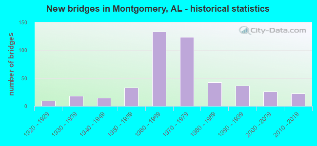
- New bridges - historical statistics
- 11910-1919
- 101920-1929
- 181930-1939
- 151940-1949
- 331950-1959
- 1331960-1969
- 1241970-1979
- 431980-1989
- 371990-1999
- 262000-2009
- 232010-2019
- 12020-2022
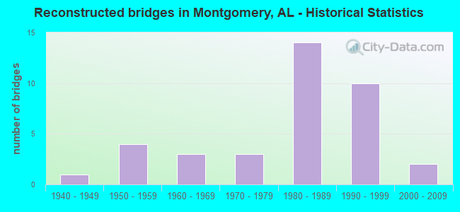
- Reconstructed bridges - Historical Statistics
- 11940-1949
- 41950-1959
- 31960-1969
- 31970-1979
- 141980-1989
- 101990-1999
- 22000-2009
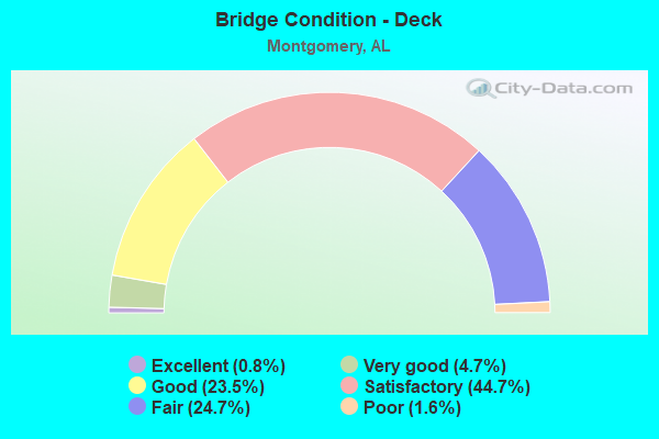
- Bridge Condition - Deck
- 0.8%Excellent
- 4.7%Very good
- 23.5%Good
- 44.7%Satisfactory
- 24.7%Fair
- 1.6%Poor
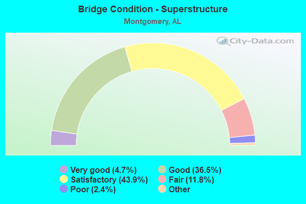
- Bridge Condition - Superstructure
- 4.7%Excellent
- 36.5%Very good
- 43.9%Good
- 11.8%Satisfactory
- 2.4%Fair
- 0.8%Poor
- 0.4%Serious
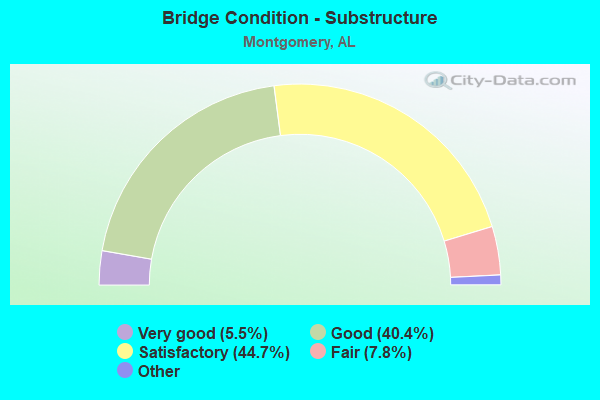
- Bridge Condition - Substructure
- 5.5%Excellent
- 40.4%Very good
- 44.7%Good
- 7.8%Satisfactory
- 1.6%Fair
- 0.8%Poor
- 0.4%Serious
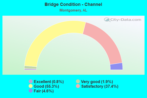
- Bridge Condition - Channel
- 0.8%Excellent
- 1.9%Very good
- 55.3%Good
- 37.4%Satisfactory
- 4.6%Fair
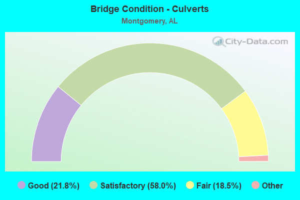
- Bridge Condition - Culverts
- 21.8%Excellent
- 58.0%Very good
- 18.5%Good
- 1.7%Satisfactory
- 18.5%Fair
Find on map >> Show street view
Structure Number: 83, Location: 1.7 MI E JCT FAP 116 (Lat: 34.888508, Lng: -86.409778), Route carried "on" structure: County highway 439, Year Built: 1914, Status: Open, Structure Length: 0.73m (2.40ft), Average Daily Traffic: 45 (year 1992), Average Future Daily Traffic: 100 (year 2034), Design Load: HS 20, Features Intersected: RODGERS BRANCH, Facility Carried by Structure: FRANK HEREFORD RD
Minimum Vertical Clearance: 30+ m (98+ ft), Kilometerpoint: 0.010, Lanes on structure: 1, Owner: County Highway Agency, Approaching Roadway Width: 6.1m (20.0ft), Skew: 2 degrees, Material/Design: Steel, Design/Construction: Stringer/Multi-beam, Number Of Spans In Main Unit: 2, Length of Maximum Span: 3.7m (12.1ft), Curb-To-Curb Width: 4.0m (13.1ft), Out-to-Out Width: 4.0m (13.1ft)
Condition: Deck: Very good, Superstructure: Good, Substructure: Fair, Channel: Fair, Operating Rating: 59.4 metric tons, Method Used To Determine Operating Rating: Load Factor (LF), Inventory Rating: 35.6 metric tons, Method Used To Determine Inventory Rating: Load Factor (LF), Structural Evaluation: Somewhat better than minimum adequacy, Deck Geometry: Somewhat better than minimum adequacy, Waterway Adequacy: Somewhat better than minimum adequacy, Approach Roadway Alignment: Somewhat better than minimum adequacy, Length Of Structure Improvement: 1.38m (4.53ft), Designated Inspection Frequency: Every 24 months, Inspection Date: August 2020, Bridge Improvement Cost: $123,000, Roadway Improvement Cost: $12,000, Total Project Cost: $135,000 ( Estimate for 2022), Deck Structure Type: Concrete Cast-file-Place
Find on map >> Show street view
Structure Number: 223, Location: 1.9 MI. E. OF OAK HILL (Lat: 31.909544, Lng: -87.056536), Route carried "on" structure: State highway 10, Year Built: 1924, Status: Open, Structure Length: 0.68m (2.23ft), Average Daily Traffic: 720 (year 2013), Truck Traffic: 19%, Average Future Daily Traffic: 938 (year 2033), Design Load: H 15, Features Intersected: LITTLE BEAR CREEK
Minimum Vertical Clearance: 30+ m (98+ ft), Kilometerpoint: 151.742, Lanes on structure: 2, Owner: State Highway Agency, Approaching Roadway Width: 9.1m (29.9ft), Material/Design: Concrete, Design/Construction: Culvert, Number Of Spans In Main Unit: 2, Length of Maximum Span: 3.0m (9.8ft), Out-to-Out Width: 12.2m (40.0ft)
Condition: Channel: Satisfactory, Culverts: Satisfactory, Operating Rating: 68.4 metric tons, Method Used To Determine Operating Rating: Load Factor (LF), Inventory Rating: 8.6 metric tons, Method Used To Determine Inventory Rating: Load Factor (LF), Structural Evaluation: High priority of corrective action, Waterway Adequacy: Better than present minimum criteria, Approach Roadway Alignment: Equal to present desirable criteria, Length Of Structure Improvement: 1.31m (4.30ft), Designated Inspection Frequency: Every 24 months, Inspection Date: June 2021, Bridge Improvement Cost: $303,000, Roadway Improvement Cost: $30,000, Total Project Cost: $333,000 ( Estimate for 2022)
Find on map >> Show street view
Structure Number: 325, Location: 3 MI SW BETHEL (Lat: 33.379500, Lng: -85.328100), Route carried "on" structure: County highway , Year Built: 1926, Status: Posted for load, Structure Length: 0.73m (2.40ft), Average Daily Traffic: 52 (year 1990), Average Future Daily Traffic: 73 (year 2030), Features Intersected: CUTNOSE CREEK, Facility Carried by Structure: CO RD 461
Minimum Vertical Clearance: 30+ m (98+ ft), Kilometerpoint: 0.010, Lanes on structure: 1, Owner: County Highway Agency, Approaching Roadway Width: 5.5m (18.0ft), Material/Design: Steel, Design/Construction: Stringer/Multi-beam, Number Of Spans In Main Unit: 1, Length of Maximum Span: 7.3m (24.0ft), Curb-To-Curb Width: 3.7m (12.1ft), Out-to-Out Width: 3.7m (12.1ft)
Condition: Deck: Fair, Superstructure: Fair, Substructure: Fair, Channel: Satisfactory, Operating Rating: 18.6 metric tons, Method Used To Determine Operating Rating: Load Factor (LF), Inventory Rating: 14.0 metric tons, Method Used To Determine Inventory Rating: Load Factor (LF), Structural Evaluation: Meets minimum limits, Deck Geometry: Meets minimum limits, Waterway Adequacy: Somewhat better than minimum adequacy, Approach Roadway Alignment: Somewhat better than minimum adequacy, Bridge Posting: Required (Relationship of Operating Rating to Maximum Legal Load: > 39.9% below), Length Of Structure Improvement: 1.38m (4.53ft), Designated Inspection Frequency: Every 24 months, Other Special Inspection Frequency: Every 12 months, Inspection Date: August 2021, Other Special Inspection Date: August 2021, Bridge Improvement Cost: $113,000, Roadway Improvement Cost: $11,000, Total Project Cost: $124,000 ( Estimate for 2022), Deck Structure Type: Wood or Timber, Wearing Surface/Protective System: Wearing Surface: Wood or Timber
Find on map >> Show street view
Structure Number: 328, Location: 15.0 MI N OF PRATTVILLE (Lat: 32.656000, Lng: -86.488900), Route carried "on" structure: US 31, Year Built: 1926, Year Reconstructed: 1953, Status: Open, Structure Length: 4.88m (16.01ft), Average Daily Traffic: 3,410 (year 2013), Truck Traffic: 7%, Average Future Daily Traffic: 4,380 (year 2033), Design Load: H 15, Features Intersected: MORTAR CREEK
Minimum Vertical Clearance: 30+ m (98+ ft), Kilometerpoint: 329.233, Lanes on structure: 2, Owner: State Highway Agency, Approaching Roadway Width: 14.0m (45.9ft), Skew: 4 degrees, Material/Design: Concrete, Design/Construction: Tee Beam, Number Of Spans In Main Unit: 6, Length of Maximum Span: 8.2m (26.9ft), Curb-To-Curb Width: 8.5m (27.9ft), Out-to-Out Width: 9.4m (30.8ft)
Condition: Deck: Good, Superstructure: Good, Substructure: Satisfactory, Channel: Satisfactory, Operating Rating: 54.6 metric tons, Method Used To Determine Operating Rating: Load Factor (LF), Inventory Rating: 32.7 metric tons, Method Used To Determine Inventory Rating: Load Factor (LF), Structural Evaluation: Equal to present minimum criteria, Deck Geometry: Meets minimum limits, Waterway Adequacy: Better than present minimum criteria, Approach Roadway Alignment: Better than present minimum criteria, Length Of Structure Improvement: 5.89m (19.32ft), Designated Inspection Frequency: Every 24 months, Inspection Date: July 2021, Bridge Improvement Cost: $1,212,000, Roadway Improvement Cost: $121,000, Total Project Cost: $1,333,000 ( Estimate for 2022), Deck Structure Type: Concrete Cast-file-Place, Wearing Surface/Protective System: Wearing Surface: Bituminous, Membrane: Built-up
Find on map >> Show street view
Structure Number: 513, Location: 1.2 MI W GA STATE LINE (Lat: 34.086389, Lng: -85.440169), Route carried "on" structure: US 411, Year Built: 1928, Status: Open, Structure Length: 0.73m (2.40ft), Average Daily Traffic: 3,338 (year 2019), Truck Traffic: 15%, Average Future Daily Traffic: 4,673 (year 2039), Features Intersected: BRANCH
Minimum Vertical Clearance: 30+ m (98+ ft), Kilometerpoint: 412.439, Lanes on structure: 2, Owner: State Highway Agency, Approaching Roadway Width: 7.3m (24.0ft), Skew: 4 degrees, Material/Design: Concrete, Design/Construction: Culvert, Number Of Spans In Main Unit: 2, Length of Maximum Span: 3.0m (9.8ft)
Condition: Channel: Satisfactory, Culverts: Satisfactory, Operating Rating: 52.7 metric tons, Method Used To Determine Operating Rating: Load Factor (LF), Inventory Rating: 31.7 metric tons, Method Used To Determine Inventory Rating: Load Factor (LF), Structural Evaluation: Equal to present minimum criteria, Waterway Adequacy: Somewhat better than minimum adequacy, Approach Roadway Alignment: Equal to present desirable criteria, Length Of Structure Improvement: 1.38m (4.53ft), Designated Inspection Frequency: Every 24 months, Inspection Date: May 2021, Bridge Improvement Cost: $421,000, Roadway Improvement Cost: $42,000, Total Project Cost: $463,000 ( Estimate for 2022), Wearing Surface/Protective System: Wearing Surface: Bituminous
Find on map >> Show street view
Structure Number: 646, Location: 0.8 MI.S.HENRY CO. L. (Lat: 31.490967, Lng: -85.426300), Route carried "on" structure: State highway 27, Year Built: 1929, Year Reconstructed: 1989, Status: Open, Structure Length: 0.64m (2.10ft), Average Daily Traffic: 960 (year 2013), Truck Traffic: 4%, Average Future Daily Traffic: 1,393 (year 2033), Design Load: H 15, Features Intersected: DEAL CREEK RELIEF
Minimum Vertical Clearance: 30+ m (98+ ft), Kilometerpoint: 102.900, Lanes on structure: 2, Owner: State Highway Agency, Approaching Roadway Width: 10.7m (35.1ft), Material/Design: Concrete, Design/Construction: Culvert, Number Of Spans In Main Unit: 2, Length of Maximum Span: 3.0m (9.8ft)
Condition: Channel: Satisfactory, Culverts: Good, Operating Rating: 70.0 metric tons, Method Used To Determine Operating Rating: Load Factor (LF), Inventory Rating: 42.0 metric tons, Method Used To Determine Inventory Rating: Load Factor (LF), Structural Evaluation: Better than present minimum criteria, Approach Roadway Alignment: Equal to present desirable criteria, Length Of Structure Improvement: 1.26m (4.13ft), Designated Inspection Frequency: Every 24 months, Inspection Date: April 2020, Bridge Improvement Cost: $320,000, Roadway Improvement Cost: $32,000, Total Project Cost: $352,000 ( Estimate for 2022)
Find on map >> Show street view
Structure Number: 992, Location: 2.0MI.N.INT.A171 JC.58 (Lat: 34.675733, Lng: -85.848669), Route carried "on" structure: County highway 58, Year Built: 1932, Year Reconstructed: 1996, Status: Open, Structure Length: 1.22m (4.00ft), Average Daily Traffic: 2,130 (year 1997), Truck Traffic: 1%, Average Future Daily Traffic: 3,250 (year 2038), Design Load: HS 20, Features Intersected: BRYANT CREEK
Minimum Vertical Clearance: 30+ m (98+ ft), Kilometerpoint: 0.010, Lanes on structure: 2, Owner: County Highway Agency, Approaching Roadway Width: 7.9m (25.9ft), Material/Design: Concrete, Design/Construction: Culvert, Number Of Spans In Main Unit: 3, Length of Maximum Span: 3.7m (12.1ft), Curb-To-Curb Width: 18.3m (60.0ft), Out-to-Out Width: 18.9m (62.0ft)
Condition: Channel: Satisfactory, Culverts: Satisfactory, Operating Rating: 71.8 metric tons, Method Used To Determine Operating Rating: Load Factor (LF), Inventory Rating: 43.1 metric tons, Method Used To Determine Inventory Rating: Load Factor (LF), Structural Evaluation: Equal to present minimum criteria, Deck Geometry: Superior to present desirable criteria, Waterway Adequacy: Equal to present desirable criteria, Approach Roadway Alignment: Better than present minimum criteria, Length Of Structure Improvement: 1.89m (6.20ft), Designated Inspection Frequency: Every 24 months, Inspection Date: November 2020, Bridge Improvement Cost: $688,000, Roadway Improvement Cost: $69,000, Total Project Cost: $757,000 ( Estimate for 2022)
Find on map >> Show street view
Structure Number: 993, Location: 0.5 MI W SR 207 (Lat: 34.829222, Lng: -87.301172), Route carried "on" structure: County highway 66, Year Built: 1932, Status: Posted for load, Structure Length: 1.16m (3.81ft), Average Daily Traffic: 225 (year 1989), Truck Traffic: 10%, Average Future Daily Traffic: 450 (year 2031), Features Intersected: BRANCH
Minimum Vertical Clearance: 30+ m (98+ ft), Kilometerpoint: 0.010, Lanes on structure: 2, Owner: County Highway Agency, Approaching Roadway Width: 9.1m (29.9ft), Material/Design: Concrete, Design/Construction: Slab, Number Of Spans In Main Unit: 2, Length of Maximum Span: 5.8m (19.0ft), Curb or Sidewalk Widths: Left: 0.1m (0.3ft), Right: 0.1m (0.3ft), Curb-To-Curb Width: 8.5m (27.9ft), Out-to-Out Width: 9.1m (29.9ft)
Condition: Deck: Fair, Superstructure: Fair, Substructure: Fair, Channel: Good, Operating Rating: 13.6 metric tons, Method Used To Determine Operating Rating: Field evaluation and documented engineering judgment, Inventory Rating: 9.9 metric tons, Method Used To Determine Inventory Rating: Field evaluation and documented engineering judgment, Structural Evaluation: High priority of replacement, Waterway Adequacy: Better than present minimum criteria, Approach Roadway Alignment: Better than present minimum criteria, Bridge Posting: Required (Relationship of Operating Rating to Maximum Legal Load: > 39.9% below), Length Of Structure Improvement: 1.84m (6.04ft), Designated Inspection Frequency: Every 24 months, Other Special Inspection Frequency: Every 12 months, Inspection Date: October 2020, Other Special Inspection Date: October 2021, Bridge Improvement Cost: $365,000, Roadway Improvement Cost: $37,000, Total Project Cost: $402,000 ( Estimate for 2022), Deck Structure Type: Concrete Cast-file-Place, Wearing Surface/Protective System: Wearing Surface: Bituminous
Find on map >> Show street view
Structure Number: 1056, Location: 0.8 MI W JCT SR 71 (Lat: 34.849783, Lng: -85.636189), Route carried "on" structure: County highway 92, Year Built: 1933, Status: Open, Structure Length: 0.73m (2.40ft), Average Daily Traffic: 60 (year 1990), Average Future Daily Traffic: 110 (year 2039), Design Load: H 10, Features Intersected: MILLER BRANCH
Minimum Vertical Clearance: 30+ m (98+ ft), Kilometerpoint: 0.010, Lanes on structure: 2, Owner: County Highway Agency, Approaching Roadway Width: 7.3m (24.0ft), Material/Design: Concrete, Design/Construction: Slab, Number Of Spans In Main Unit: 2, Length of Maximum Span: 3.7m (12.1ft), Curb-To-Curb Width: 6.1m (20.0ft), Out-to-Out Width: 6.7m (22.0ft)
Condition: Deck: Satisfactory, Superstructure: Satisfactory, Substructure: Satisfactory, Channel: Satisfactory, Operating Rating: 32.7 metric tons, Method Used To Determine Operating Rating: Field evaluation and documented engineering judgment, Inventory Rating: 23.6 metric tons, Method Used To Determine Inventory Rating: Field evaluation and documented engineering judgment, Structural Evaluation: Equal to present minimum criteria, Deck Geometry: Somewhat better than minimum adequacy, Waterway Adequacy: Equal to present minimum criteria, Approach Roadway Alignment: Equal to present minimum criteria, Length Of Structure Improvement: 1.38m (4.53ft), Designated Inspection Frequency: Every 24 months, Inspection Date: March 2021, Bridge Improvement Cost: $208,000, Roadway Improvement Cost: $21,000, Total Project Cost: $229,000 ( Estimate for 2022)
Find on map >> Show street view
Structure Number: 1088, Location: PHENIX CITY (Lat: 32.465500, Lng: -85.000700), Route carried "on" structure: City street , Year Built: 1934, Status: Open, Structure Length: 8.24m (27.03ft), Average Daily Traffic: 16,975 (year 2022), Truck Traffic: 10%, Average Future Daily Traffic: 20,000 (year 2042), Design Load: H 15, Features Intersected: HOLLAND CREEK, Facility Carried by Structure: BROAD STREET
Minimum Vertical Clearance: 30.18m (99.02ft), Kilometerpoint: 0.900, Lanes on structure: 4, Base Highway Network: Yes, Owner: City or Municipal Highway Agency, Approaching Roadway Width: 12.1m (39.7ft), Skew: 20 degrees, Material/Design: Steel continuous, Design/Construction: Stringer/Multi-beam, Number Of Spans In Main Unit: 5, Length of Maximum Span: 16.5m (54.1ft), Curb or Sidewalk Widths: Left: 1.2m (3.9ft), Right: 1.2m (3.9ft), Curb-To-Curb Width: 12.1m (39.7ft), Out-to-Out Width: 15.2m (49.9ft)
Condition: Deck: Satisfactory, Superstructure: Satisfactory, Substructure: Fair, Channel: Satisfactory, Operating Rating: 39.8 metric tons, Method Used To Determine Operating Rating: Load Factor (LF), Inventory Rating: 23.9 metric tons, Method Used To Determine Inventory Rating: Load Factor (LF), Structural Evaluation: Somewhat better than minimum adequacy, Deck Geometry: High priority of replacement, Waterway Adequacy: Equal to present minimum criteria, Approach Roadway Alignment: Better than present minimum criteria, Length Of Structure Improvement: 9.24m (30.31ft), Designated Inspection Frequency: Every 24 months, Inspection Date: January 2022, Bridge Improvement Cost: $3,167,000, Roadway Improvement Cost: $317,000, Total Project Cost: $3,484,000 ( Estimate for 2022), Deck Structure Type: Concrete Cast-file-Place
Find on map >> Show street view
Structure Number: 1552, Location: 0.25 MI N OF COLUMBUS ST (Lat: 3.385739, Lng: -86.298419), Route carried "on" structure: City street , Year Built: 1937, Status: Open, Structure Length: 4.05m (13.29ft), Average Daily Traffic: 9,100 (year 1992), Truck Traffic: 4%, Average Future Daily Traffic: 10,201 (year 2038), Design Load: H 15, Features Intersected: C. OF GA. RR, Facility Carried by Structure: N. RIPLEY ST.
Minimum Vertical Clearance: 30+ m (98+ ft), Kilometerpoint: 1.199, Lanes on structure: 2, Owner: City or Municipal Highway Agency, Approaching Roadway Width: 11.0m (36.1ft), Material/Design: Concrete, Design/Construction: Tee Beam, Number Of Spans In Main Unit: 5, Length of Maximum Span: 7.6m (24.9ft), Curb or Sidewalk Widths: Left: 1.5m (4.9ft), Right: 0.0m, Curb-To-Curb Width: 11.0m (36.1ft), Out-to-Out Width: 12.6m (41.3ft)
Condition: Deck: Satisfactory, Superstructure: Fair, Substructure: Fair, Operating Rating: 49.4 metric tons, Method Used To Determine Operating Rating: Load Factor (LF), Inventory Rating: 29.6 metric tons, Method Used To Determine Inventory Rating: Load Factor (LF), Structural Evaluation: Somewhat better than minimum adequacy, Deck Geometry: Meets minimum limits, Approach Roadway Alignment: Better than present minimum criteria, Length Of Structure Improvement: 5.01m (16.44ft), Designated Inspection Frequency: Every 24 months, Inspection Date: Febuary 2022, Bridge Improvement Cost: $1,408,000, Roadway Improvement Cost: $141,000, Total Project Cost: $1,549,000 ( Estimate for 2022), Deck Structure Type: Concrete Cast-file-Place
Find on map >> Show street view
Structure Number: 1553, Location: 0.3 MI N OF COLUMBUS ST (Lat: 32.386794, Lng: -86.298353), Route carried "on" structure: City street , Year Built: 1937, Status: Open, Structure Length: 0.82m (2.69ft), Average Daily Traffic: 9,100 (year 1992), Truck Traffic: 4%, Average Future Daily Traffic: 10,201 (year 2038), Design Load: H 15, Features Intersected: GOLDBUG ST., Facility Carried by Structure: NORTH RIPLEY ST
Minimum Vertical Clearance: 30+ m (98+ ft), Kilometerpoint: 1.299, Lanes on structure: 2, Lanes under structure: 2, Owner: City or Municipal Highway Agency, Approaching Roadway Width: 11.0m (36.1ft), Material/Design: Concrete, Design/Construction: Tee Beam, Number Of Spans In Main Unit: 1, Length of Maximum Span: 8.2m (26.9ft), Curb or Sidewalk Widths: Left: 1.5m (4.9ft), Right: 0.0m, Curb-To-Curb Width: 11.0m (36.1ft), Out-to-Out Width: 12.7m (41.7ft)
Condition: Deck: Satisfactory, Superstructure: Satisfactory, Substructure: Satisfactory, Operating Rating: 49.4 metric tons, Method Used To Determine Operating Rating: Load Factor (LF), Inventory Rating: 29.6 metric tons, Method Used To Determine Inventory Rating: Load Factor (LF), Structural Evaluation: Equal to present minimum criteria, Deck Geometry: Meets minimum limits, Underclear: High priority of corrective action, Approach Roadway Alignment: Equal to present minimum criteria, Length Of Structure Improvement: 1.48m (4.86ft), Designated Inspection Frequency: Every 24 months, Inspection Date: Febuary 2022, Bridge Improvement Cost: $416,000, Roadway Improvement Cost: $42,000, Total Project Cost: $458,000 ( Estimate for 2022), Deck Structure Type: Concrete Cast-file-Place
Find on map >> Show street view
Structure Number: 1554, Location: 0.2 MI S of BROADWAY ST (Lat: 32.409869, Lng: -86.287756), Route carried "on" structure: City street , Year Built: 1937, Status: Open, Structure Length: 5.73m (18.80ft), Average Daily Traffic: 9,100 (year 1993), Truck Traffic: 2%, Average Future Daily Traffic: 10,100 (year 2038), Design Load: H 15, Features Intersected: SCL RR, Facility Carried by Structure: LOWER WETUMPKA RD
Minimum Vertical Clearance: 30+ m (98+ ft), Kilometerpoint: 2.898, Lanes on structure: 2, Owner: City or Municipal Highway Agency, Approaching Roadway Width: 11.0m (36.1ft), Material/Design: Steel continuous, Design/Construction: Stringer/Multi-beam, Number Of Spans In Main Unit: 3, Number Of Approach Spans: 3, Length of Maximum Span: 11.9m (39.0ft), Curb or Sidewalk Widths: Left: 1.5m (4.9ft), Right: 0.0m, Curb-To-Curb Width: 11.0m (36.1ft), Out-to-Out Width: 13.4m (44.0ft)
Condition: Deck: Fair, Superstructure: Fair, Substructure: Fair, Operating Rating: 57.8 metric tons, Method Used To Determine Operating Rating: Load Factor (LF), Inventory Rating: 34.7 metric tons, Method Used To Determine Inventory Rating: Load Factor (LF), Structural Evaluation: Somewhat better than minimum adequacy, Deck Geometry: Meets minimum limits, Underclear: Meets minimum limits, Approach Roadway Alignment: Better than present minimum criteria, Length Of Structure Improvement: 6.77m (22.21ft), Designated Inspection Frequency: Every 24 months, Inspection Date: Febuary 2022, Bridge Improvement Cost: $2,042,000, Roadway Improvement Cost: $204,000, Total Project Cost: $2,246,000 ( Estimate for 2022), Deck Structure Type: Concrete Cast-file-Place
Find on map >> Show street view
Structure Number: 1678, Location: 0.4 MI SO CO RD 469 (Lat: 34.830406, Lng: -86.412339), Route carried "on" structure: County highway 468, Year Built: 1937, Status: Posted for load, Structure Length: 0.76m (2.49ft), Average Daily Traffic: 420 (year 1992), Truck Traffic: 1%, Average Future Daily Traffic: 530 (year 2040), Design Load: H 15, Features Intersected: ELDER BRANCH, Facility Carried by Structure: HURRICANE RD
Minimum Vertical Clearance: 30+ m (98+ ft), Kilometerpoint: 0.010, Lanes on structure: 2, Owner: County Highway Agency, Approaching Roadway Width: 8.5m (27.9ft), Skew: 1 degrees, Material/Design: Steel, Design/Construction: Stringer/Multi-beam, Number Of Spans In Main Unit: 1, Length of Maximum Span: 7.6m (24.9ft), Curb-To-Curb Width: 5.9m (19.4ft), Out-to-Out Width: 6.8m (22.3ft)
Condition: Deck: Fair, Superstructure: Satisfactory, Substructure: Satisfactory, Channel: Satisfactory, Operating Rating: 36.0 metric tons, Method Used To Determine Operating Rating: Load Factor (LF), Inventory Rating: 21.6 metric tons, Method Used To Determine Inventory Rating: Load Factor (LF), Structural Evaluation: Equal to present minimum criteria, Deck Geometry: High priority of replacement, Waterway Adequacy: Equal to present minimum criteria, Approach Roadway Alignment: Somewhat better than minimum adequacy, Bridge Posting: Required (Relationship of Operating Rating to Maximum Legal Load: 20.0 - 29.9% below), Length Of Structure Improvement: 1.41m (4.63ft), Designated Inspection Frequency: Every 24 months, Other Special Inspection Frequency: Every 12 months, Inspection Date: January 2021, Other Special Inspection Date: January 2022, Bridge Improvement Cost: $212,000, Roadway Improvement Cost: $21,000, Total Project Cost: $233,000 ( Estimate for 2022), Deck Structure Type: Concrete Cast-file-Place
Find on map >> Show street view
Structure Number: 1719, Location: 2.2 MI.N.OF FLATWOOD (Lat: 32.167811, Lng: -87.493828), Route carried "on" structure: State highway 5, Year Built: 1938, Status: Open, Structure Length: 2.71m (8.89ft), Average Daily Traffic: 1,950 (year 2013), Truck Traffic: 28%, Average Future Daily Traffic: 2,441 (year 2033), Design Load: H 15, Features Intersected: DIXONS CRK
Minimum Vertical Clearance: 30+ m (98+ ft), Kilometerpoint: 41.153, Lanes on structure: 2, Base Highway Network: Yes, Owner: State Highway Agency, Approaching Roadway Width: 9.8m (32.2ft), Material/Design: Steel, Design/Construction: Stringer/Multi-beam, Number Of Spans In Main Unit: 4, Length of Maximum Span: 6.7m (22.0ft), Curb-To-Curb Width: 7.2m (23.6ft), Out-to-Out Width: 7.6m (24.9ft)
Condition: Deck: Fair, Superstructure: Fair, Substructure: Satisfactory, Channel: Satisfactory, Operating Rating: 60.9 metric tons, Method Used To Determine Operating Rating: Load Factor (LF), Inventory Rating: 36.5 metric tons, Method Used To Determine Inventory Rating: Load Factor (LF), Structural Evaluation: Somewhat better than minimum adequacy, Deck Geometry: High priority of corrective action, Waterway Adequacy: Better than present minimum criteria, Approach Roadway Alignment: Better than present minimum criteria, Length Of Structure Improvement: 3.63m (11.91ft), Designated Inspection Frequency: Every 24 months, Inspection Date: March 2020, Bridge Improvement Cost: $597,000, Roadway Improvement Cost: $60,000, Total Project Cost: $657,000 ( Estimate for 2022), Deck Structure Type: Concrete Cast-file-Place, Wearing Surface/Protective System: Wearing Surface: Bituminous
Find on map >> Show street view
Structure Number: 1896, Location: 2.1MI N JCT SR 65 (Lat: 34.742639, Lng: -86.322172), Route carried "on" structure: County highway 1, Year Built: 1939, Status: Posted for load, Structure Length: 0.91m (2.99ft), Average Daily Traffic: 40 (year 1989), Truck Traffic: 1%, Average Future Daily Traffic: 69 (year 2039), Design Load: H 10, Features Intersected: LITTLE DRY CREEK
Minimum Vertical Clearance: 30+ m (98+ ft), Kilometerpoint: 0.010, Lanes on structure: 2, Owner: County Highway Agency, Approaching Roadway Width: 7.3m (24.0ft), Material/Design: Steel, Design/Construction: Stringer/Multi-beam, Number Of Spans In Main Unit: 1, Length of Maximum Span: 9.1m (29.9ft), Curb-To-Curb Width: 6.7m (22.0ft), Out-to-Out Width: 7.8m (25.6ft)
Condition: Deck: Good, Superstructure: Satisfactory, Substructure: Satisfactory, Channel: Good, Operating Rating: 15.9 metric tons, Method Used To Determine Operating Rating: Allowable Stress (AS), Inventory Rating: 7.9 metric tons, Method Used To Determine Inventory Rating: Allowable Stress (AS), Structural Evaluation: High priority of corrective action, Deck Geometry: Somewhat better than minimum adequacy, Waterway Adequacy: Equal to present desirable criteria, Approach Roadway Alignment: Equal to present minimum criteria, Bridge Posting: Required (Relationship of Operating Rating to Maximum Legal Load: > 39.9% below), Length Of Structure Improvement: 1.58m (5.18ft), Designated Inspection Frequency: Every 24 months, Other Special Inspection Frequency: Every 12 months, Inspection Date: December 2021, Other Special Inspection Date: December 2021, Bridge Improvement Cost: $271,000, Roadway Improvement Cost: $27,000, Total Project Cost: $298,000 ( Estimate for 2022), Deck Structure Type: Concrete Cast-file-Place
Find on map >> Show street view
Structure Number: 193, Location: 3.9 MI. N. OF JACHIN (Lat: 32.283356, Lng: -88.172708), Route carried "on" structure: State highway 17, Year Built: 1939, Status: Open, Structure Length: 0.97m (3.18ft), Average Daily Traffic: 1,590 (year 2013), Truck Traffic: 28%, Average Future Daily Traffic: 2,051 (year 2033), Design Load: H 15, Features Intersected: BRANCH
Minimum Vertical Clearance: 30+ m (98+ ft), Kilometerpoint: 198.427, Lanes on structure: 2, Owner: State Highway Agency, Approaching Roadway Width: 9.1m (29.9ft), Skew: 4 degrees, Material/Design: Concrete, Design/Construction: Culvert, Number Of Spans In Main Unit: 2, Length of Maximum Span: 3.0m (9.8ft)
Condition: Channel: Satisfactory, Culverts: Satisfactory, Operating Rating: 88.9 metric tons, Method Used To Determine Operating Rating: Load Factor (LF), Inventory Rating: 65.9 metric tons, Method Used To Determine Inventory Rating: Load Factor (LF), Structural Evaluation: Equal to present minimum criteria, Waterway Adequacy: Equal to present minimum criteria, Approach Roadway Alignment: Equal to present desirable criteria, Length Of Structure Improvement: 1.64m (5.38ft), Designated Inspection Frequency: Every 24 months, Inspection Date: November 2020, Bridge Improvement Cost: $635,000, Roadway Improvement Cost: $64,000, Total Project Cost: $699,000 ( Estimate for 2022)
Find on map >> Show street view
Structure Number: 1992, Location: .1 MI S ALA 202 (Lat: 33.607167, Lng: -85.979600), Route carried "on" structure: City street , Year Built: 1939, Status: Temporarily open, Structure Length: 0.91m (2.99ft), Average Daily Traffic: 150 (year 2020), Truck Traffic: 1%, Average Future Daily Traffic: 200 (year 2040), Features Intersected: BRANCH, Facility Carried by Structure: TAYLORS CHAPEL RD
Minimum Vertical Clearance: 30+ m (98+ ft), Kilometerpoint: 0.161, Lanes on structure: 1, Owner: City or Municipal Highway Agency, Approaching Roadway Width: 6.1m (20.0ft), Material/Design: Steel, Design/Construction: Stringer/Multi-beam, Number Of Spans In Main Unit: 2, Length of Maximum Span: 4.6m (15.1ft), Curb-To-Curb Width: 5.5m (18.0ft), Out-to-Out Width: 6.1m (20.0ft)
Condition: Deck: Satisfactory, Superstructure: Good, Substructure: Fair, Channel: Fair, Operating Rating: 5.2 metric tons, Method Used To Determine Operating Rating: Load Factor (LF), Inventory Rating: 3.1 metric tons, Method Used To Determine Inventory Rating: Load Factor (LF), Structural Evaluation: High priority of replacement, Deck Geometry: High priority of corrective action, Waterway Adequacy: Somewhat better than minimum adequacy, Approach Roadway Alignment: Equal to present minimum criteria, Length Of Structure Improvement: 1.59m (5.22ft), Designated Inspection Frequency: Every 24 months, Inspection Date: August 2020, Bridge Improvement Cost: $207,000, Roadway Improvement Cost: $21,000, Total Project Cost: $228,000 ( Estimate for 2022), Deck Structure Type: Concrete Cast-file-Place
Find on map >> Show street view
Structure Number: 2058, Location: 0.4 MI W JCT CO RT 28 (Lat: 34.436261, Lng: -87.450169), Route carried "on" structure: County highway 29, Year Built: 1939, Status: Posted for load, Structure Length: 0.82m (2.69ft), Average Daily Traffic: 50 (year 1987), Average Future Daily Traffic: 150 (year 2036), Features Intersected: MILAM CREEK
Minimum Vertical Clearance: 30+ m (98+ ft), Kilometerpoint: 0.010, Lanes on structure: 1, Owner: County Highway Agency, Approaching Roadway Width: 4.6m (15.1ft), Material/Design: Steel, Design/Construction: Stringer/Multi-beam, Number Of Spans In Main Unit: 1, Length of Maximum Span: 8.2m (26.9ft), Curb-To-Curb Width: 4.9m (16.1ft), Out-to-Out Width: 4.9m (16.1ft)
Condition: Deck: Excellent, Superstructure: Satisfactory, Substructure: Satisfactory, Channel: Satisfactory, Operating Rating: 24.5 metric tons, Method Used To Determine Operating Rating: Allowable Stress (AS), Inventory Rating: 18.3 metric tons, Method Used To Determine Inventory Rating: Allowable Stress (AS), Structural Evaluation: Somewhat better than minimum adequacy, Deck Geometry: High priority of corrective action, Waterway Adequacy: Equal to present minimum criteria, Approach Roadway Alignment: Equal to present minimum criteria, Bridge Posting: Required (Relationship of Operating Rating to Maximum Legal Load: 20.0 - 29.9% below), Length Of Structure Improvement: 1.48m (4.86ft), Designated Inspection Frequency: Every 24 months, Other Special Inspection Frequency: Every 12 months, Inspection Date: October 2020, Other Special Inspection Date: October 2021, Bridge Improvement Cost: $162,000, Roadway Improvement Cost: $16,000, Total Project Cost: $178,000 ( Estimate for 2022), Deck Structure Type: Wood or Timber, Wearing Surface/Protective System: Wearing Surface: Wood or Timber
Find on map >> Show street view
Structure Number: 2241, Location: SYLACAUGA (Lat: 33.166667, Lng: -86.283333), Route carried "on" structure: City street , Year Built: 1940, Status: Open, Structure Length: 1.83m (6.00ft), Average Daily Traffic: 700 (year 2021), Truck Traffic: 5%, Average Future Daily Traffic: 850 (year 2041), Design Load: H 15, Features Intersected: CROOKED CREEK, Facility Carried by Structure: E FT WILLIAMS ST
Minimum Vertical Clearance: 30+ m (98+ ft), Kilometerpoint: 2.300, Lanes on structure: 2, Owner: City or Municipal Highway Agency, Approaching Roadway Width: 6.1m (20.0ft), Material/Design: Concrete, Design/Construction: Culvert, Number Of Spans In Main Unit: 4, Length of Maximum Span: 4.4m (14.4ft), Curb or Sidewalk Widths: Left: 0.2m (0.7ft), Right: 0.2m (0.7ft), Curb-To-Curb Width: 8.0m (26.2ft), Out-to-Out Width: 8.5m (27.9ft)
Condition: Channel: Satisfactory, Culverts: Fair, Operating Rating: 43.5 metric tons, Method Used To Determine Operating Rating: Field evaluation and documented engineering judgment, Inventory Rating: 32.7 metric tons, Method Used To Determine Inventory Rating: Field evaluation and documented engineering judgment, Structural Evaluation: Somewhat better than minimum adequacy, Deck Geometry: Somewhat better than minimum adequacy, Waterway Adequacy: Equal to present minimum criteria, Approach Roadway Alignment: Equal to present desirable criteria, Length Of Structure Improvement: 2.54m (8.33ft), Designated Inspection Frequency: Every 24 months, Inspection Date: April 2021, Bridge Improvement Cost: $411,000, Roadway Improvement Cost: $41,000, Total Project Cost: $452,000 ( Estimate for 2022), Deck Structure Type: Concrete Cast-file-Place
Find on map >> Show street view
Structure Number: 2246, Location: TALLADEGA (Lat: 33.433300, Lng: -86.083400), Route carried "on" structure: City street , Year Built: 1940, Status: Open, Structure Length: 0.85m (2.79ft), Average Daily Traffic: 500 (year 2011), Truck Traffic: 5%, Average Future Daily Traffic: 743 (year 2041), Design Load: H 15, Features Intersected: ISBELL BRANCH, Facility Carried by Structure: N SPRING STREET
Minimum Vertical Clearance: 30+ m (98+ ft), Kilometerpoint: 0.200, Lanes on structure: 2, Owner: City or Municipal Highway Agency, Approaching Roadway Width: 6.1m (20.0ft), Skew: 3 degrees, Material/Design: Concrete, Design/Construction: Culvert, Number Of Spans In Main Unit: 1, Length of Maximum Span: 8.5m (27.9ft), Curb or Sidewalk Widths: Left: 0.9m (3.0ft), Right: 0.9m (3.0ft)
Condition: Channel: Satisfactory, Culverts: Fair, Operating Rating: 32.7 metric tons, Method Used To Determine Operating Rating: Field evaluation and documented engineering judgment, Inventory Rating: 23.6 metric tons, Method Used To Determine Inventory Rating: Field evaluation and documented engineering judgment, Structural Evaluation: Somewhat better than minimum adequacy, Waterway Adequacy: Equal to present desirable criteria, Approach Roadway Alignment: Meets minimum limits, Length Of Structure Improvement: 1.51m (4.95ft), Designated Inspection Frequency: Every 24 months, Inspection Date: January 2021, Bridge Improvement Cost: $880,000, Roadway Improvement Cost: $88,000, Total Project Cost: $968,000 ( Estimate for 2022)
Find on map >> Show street view
Structure Number: 2756, Location: 1.4 MI.E.0F WESTERNBYPASS (Lat: 32.368561, Lng: -86.356192), Route carried "on" structure: City street , Year Built: 1943, Status: Open, Structure Length: 0.61m (2.00ft), Average Daily Traffic: 18,950 (year 1988), Truck Traffic: 3%, Average Future Daily Traffic: 26,530 (year 2040), Design Load: H 15, Features Intersected: STREAM, Facility Carried by Structure: BELL STREET
Minimum Vertical Clearance: 5.26m (17.26ft), Kilometerpoint: 1.399, Lanes on structure: 4, Owner: City or Municipal Highway Agency, Approaching Roadway Width: 12.2m (40.0ft), Skew: 14 degrees, Material/Design: Concrete continuous, Design/Construction: Culvert, Number Of Spans In Main Unit: 2, Length of Maximum Span: 3.0m (9.8ft)
Condition: Channel: Satisfactory, Culverts: Satisfactory, Operating Rating: 48.8 metric tons, Method Used To Determine Operating Rating: Load Factor (LF), Inventory Rating: 29.3 metric tons, Method Used To Determine Inventory Rating: Load Factor (LF), Structural Evaluation: Equal to present minimum criteria, Waterway Adequacy: Better than present minimum criteria, Approach Roadway Alignment: Better than present minimum criteria, Length Of Structure Improvement: 1.22m (4.00ft), Designated Inspection Frequency: Every 24 months, Inspection Date: April 2020, Bridge Improvement Cost: $2,330,000, Roadway Improvement Cost: $233,000, Total Project Cost: $2,563,000 ( Estimate for 2022)
Find on map >> Show street view
Structure Number: 2767, Location: 0.1 MI S OF DAY ST (Lat: 32.368214, Lng: -86.349236), Route carried "on" structure: City street , Year Built: 1943, Status: Open, Structure Length: 0.67m (2.20ft), Average Daily Traffic: 13,600 (year 1988), Truck Traffic: 2%, Average Future Daily Traffic: 18,900 (year 2038), Design Load: H 20, Features Intersected: STREAM, Facility Carried by Structure: Air Base Blvd.
Minimum Vertical Clearance: 30+ m (98+ ft), Kilometerpoint: 1.699, Lanes on structure: 4, Owner: City or Municipal Highway Agency, Approaching Roadway Width: 32.3m (106.0ft), Skew: 20 degrees, Material/Design: Concrete continuous, Design/Construction: Culvert, Number Of Spans In Main Unit: 2, Length of Maximum Span: 3.0m (9.8ft)
Condition: Channel: Good, Culverts: Good, Operating Rating: 48.4 metric tons, Method Used To Determine Operating Rating: Load Factor (LF), Inventory Rating: 29.0 metric tons, Method Used To Determine Inventory Rating: Load Factor (LF), Structural Evaluation: Better than present minimum criteria, Waterway Adequacy: Equal to present minimum criteria, Approach Roadway Alignment: Better than present minimum criteria, Length Of Structure Improvement: 1.30m (4.27ft), Designated Inspection Frequency: Every 24 months, Inspection Date: August 2020, Bridge Improvement Cost: $811,000, Roadway Improvement Cost: $81,000, Total Project Cost: $892,000 ( Estimate for 2022)
Find on map >> Show street view
Structure Number: 2768, Location: 0.25 MI E OF AIRBASE BLVD (Lat: 32.369700, Lng: -86.352600), Route carried "on" structure: City street , Year Built: 1943, Status: Posted for load, Structure Length: 8.90m (29.20ft), Average Daily Traffic: 13,600 (year 1992), Truck Traffic: 2%, Average Future Daily Traffic: 19,089 (year 2040), Design Load: H 15, Features Intersected: ICE RR, Facility Carried by Structure: DAY ST
Minimum Vertical Clearance: 30+ m (98+ ft), Kilometerpoint: 1.999, Lanes on structure: 2, Owner: City or Municipal Highway Agency, Approaching Roadway Width: 11.6m (38.1ft), Skew: 4 degrees, Material/Design: Concrete, Design/Construction: Tee Beam, Number Of Spans In Main Unit: 7, Length of Maximum Span: 14.0m (45.9ft), Curb-To-Curb Width: 7.9m (25.9ft), Out-to-Out Width: 8.8m (28.9ft)
Condition: Deck: Satisfactory, Superstructure: Satisfactory, Substructure: Satisfactory, Operating Rating: 30.7 metric tons, Method Used To Determine Operating Rating: Load Factor (LF), Inventory Rating: 18.3 metric tons, Method Used To Determine Inventory Rating: Load Factor (LF), Structural Evaluation: Meets minimum limits, Deck Geometry: High priority of corrective action, Underclear: Meets minimum limits, Approach Roadway Alignment: Better than present minimum criteria, Bridge Posting: Required (Relationship of Operating Rating to Maximum Legal Load: 20.0 - 29.9% below), Length Of Structure Improvement: 9.87m (32.38ft), Designated Inspection Frequency: Every 24 months, Other Special Inspection Frequency: Every 12 months, Inspection Date: November 2020, Other Special Inspection Date: November 2021, Bridge Improvement Cost: $1,896,000, Roadway Improvement Cost: $190,000, Total Project Cost: $2,086,000 ( Estimate for 2022), Deck Structure Type: Concrete Cast-file-Place
Find on map >> Show street view
Structure Number: 2958, Location: 0.8 MI.W. HUNTER LOOP RD. (Lat: 32.343100, Lng: -86.393600), Route carried "on" structure: County highway 74, Year Built: 1946, Status: Posted for load, Structure Length: 3.11m (10.20ft), Average Daily Traffic: 2,600 (year 1992), Truck Traffic: 6%, Average Future Daily Traffic: 4,000 (year 2038), Design Load: H 15, Features Intersected: CATOMA CREEK RELIEF, Facility Carried by Structure: OLD SELMA RD
Minimum Vertical Clearance: 30+ m (98+ ft), Kilometerpoint: 0.800, Lanes on structure: 2, Owner: City or Municipal Highway Agency, Approaching Roadway Width: 9.1m (29.9ft), Material/Design: Steel, Design/Construction: Stringer/Multi-beam, Number Of Spans In Main Unit: 3, Length of Maximum Span: 10.4m (34.1ft), Curb-To-Curb Width: 7.3m (24.0ft), Out-to-Out Width: 8.8m (28.9ft)
Condition: Deck: Satisfactory, Superstructure: Poor, Substructure: Satisfactory, Channel: Good, Operating Rating: 23.5 metric tons, Method Used To Determine Operating Rating: Allowable Stress (AS), Inventory Rating: 14.1 metric tons, Method Used To Determine Inventory Rating: Allowable Stress (AS), Structural Evaluation: Meets minimum limits, Deck Geometry: High priority of replacement, Waterway Adequacy: Better than present minimum criteria, Approach Roadway Alignment: Equal to present minimum criteria, Bridge Posting: Required (Relationship of Operating Rating to Maximum Legal Load: > 39.9% below), Length Of Structure Improvement: 3.96m (12.99ft), Designated Inspection Frequency: Every 24 months, Other Special Inspection Frequency: Every 12 months, Inspection Date: October 2020, Other Special Inspection Date: October 2021, Bridge Improvement Cost: $760,000, Roadway Improvement Cost: $76,000, Total Project Cost: $836,000 ( Estimate for 2022), Deck Structure Type: Concrete Cast-file-Place, Wearing Surface/Protective System: Wearing Surface: Bituminous
Find on map >> Show street view
Structure Number: 2959, Location: 0.9 MI.W. HUNTER LOOP RD. (Lat: 32.343100, Lng: -86.395500), Route carried "on" structure: County highway 74, Year Built: 1946, Status: Posted for load, Structure Length: 2.13m (6.99ft), Average Daily Traffic: 2,600 (year 1992), Truck Traffic: 6%, Average Future Daily Traffic: 4,000 (year 2038), Design Load: H 15, Features Intersected: CATOMA CREEK RELIEF, Facility Carried by Structure: OLD SELMA RD
Minimum Vertical Clearance: 30+ m (98+ ft), Kilometerpoint: 0.900, Lanes on structure: 2, Owner: City or Municipal Highway Agency, Approaching Roadway Width: 8.5m (27.9ft), Material/Design: Steel, Design/Construction: Stringer/Multi-beam, Number Of Spans In Main Unit: 2, Length of Maximum Span: 10.7m (35.1ft), Curb-To-Curb Width: 7.3m (24.0ft), Out-to-Out Width: 8.8m (28.9ft)
Condition: Deck: Satisfactory, Superstructure: Poor, Substructure: Satisfactory, Channel: Satisfactory, Operating Rating: 22.3 metric tons, Method Used To Determine Operating Rating: Load Factor (LF), Inventory Rating: 13.4 metric tons, Method Used To Determine Inventory Rating: Load Factor (LF), Structural Evaluation: Meets minimum limits, Deck Geometry: High priority of replacement, Waterway Adequacy: Better than present minimum criteria, Approach Roadway Alignment: Equal to present minimum criteria, Bridge Posting: Required (Relationship of Operating Rating to Maximum Legal Load: > 39.9% below), Length Of Structure Improvement: 2.91m (9.55ft), Designated Inspection Frequency: Every 24 months, Other Special Inspection Frequency: Every 12 months, Inspection Date: October 2020, Other Special Inspection Date: October 2021, Bridge Improvement Cost: $559,000, Roadway Improvement Cost: $56,000, Total Project Cost: $615,000 ( Estimate for 2022), Deck Structure Type: Concrete Cast-file-Place
Find on map >> Show street view
Structure Number: 3047, Location: 0.75 MI W OF VIR. LOOP (Lat: 32.304031, Lng: -86.247161), Route carried "on" structure: City street , Year Built: 1947, Status: Posted for load, Structure Length: 2.56m (8.40ft), Average Daily Traffic: 3,100 (year 1993), Truck Traffic: 1%, Average Future Daily Traffic: 5,050 (year 2038), Design Load: H 10, Features Intersected: WHITES SLOUGH, Facility Carried by Structure: WOODLEY RD.
Minimum Vertical Clearance: 30+ m (98+ ft), Kilometerpoint: 0.100, Lanes on structure: 2, Owner: City or Municipal Highway Agency, Approaching Roadway Width: 8.5m (27.9ft), Material/Design: Steel, Design/Construction: Stringer/Multi-beam, Number Of Spans In Main Unit: 3, Length of Maximum Span: 8.5m (27.9ft), Curb-To-Curb Width: 7.3m (24.0ft), Out-to-Out Width: 8.4m (27.6ft)
Condition: Deck: Poor, Superstructure: Poor, Substructure: Fair, Channel: Satisfactory, Operating Rating: 2.7 metric tons, Method Used To Determine Operating Rating: Load Factor (LF), Inventory Rating: 1.8 metric tons, Method Used To Determine Inventory Rating: Load Factor (LF), Structural Evaluation: High priority of replacement, Deck Geometry: High priority of replacement, Waterway Adequacy: Equal to present minimum criteria, Approach Roadway Alignment: Equal to present minimum criteria, Bridge Posting: Required (Relationship of Operating Rating to Maximum Legal Load: > 39.9% below), Length Of Structure Improvement: 3.46m (11.35ft), Designated Inspection Frequency: Every 24 months, Other Special Inspection Frequency: Every 12 months, Inspection Date: May 2020, Other Special Inspection Date: May 2021, Bridge Improvement Cost: $640,000, Roadway Improvement Cost: $64,000, Total Project Cost: $704,000 ( Estimate for 2022), Deck Structure Type: Concrete Cast-file-Place, Wearing Surface/Protective System: Wearing Surface: Bituminous
Find on map >> Show street view
Structure Number: 3048, Location: 0.8 MI W OF VIR. LOOP (Lat: 32.304392, Lng: -86.247689), Route carried "on" structure: City street , Year Built: 1947, Status: Posted for load, Structure Length: 0.98m (3.22ft), Average Daily Traffic: 3,100 (year 1993), Truck Traffic: 1%, Average Future Daily Traffic: 5,100 (year 2038), Design Load: H 10, Features Intersected: WHITES SLOUGH, Facility Carried by Structure: WOODLEY RD.
Minimum Vertical Clearance: 30+ m (98+ ft), Kilometerpoint: 0.200, Lanes on structure: 2, Owner: City or Municipal Highway Agency, Approaching Roadway Width: 8.5m (27.9ft), Material/Design: Concrete, Design/Construction: Slab, Number Of Spans In Main Unit: 2, Length of Maximum Span: 4.9m (16.1ft), Curb-To-Curb Width: 7.0m (23.0ft), Out-to-Out Width: 8.4m (27.6ft)
Condition: Deck: Poor, Superstructure: Poor, Substructure: Fair, Channel: Satisfactory, Operating Rating: 13.4 metric tons, Method Used To Determine Operating Rating: Field evaluation and documented engineering judgment, Inventory Rating: 11.6 metric tons, Method Used To Determine Inventory Rating: Field evaluation and documented engineering judgment, Structural Evaluation: High priority of replacement, Deck Geometry: High priority of replacement, Waterway Adequacy: Equal to present minimum criteria, Approach Roadway Alignment: Equal to present minimum criteria, Bridge Posting: Required (Relationship of Operating Rating to Maximum Legal Load: > 39.9% below), Length Of Structure Improvement: 1.65m (5.41ft), Designated Inspection Frequency: Every 24 months, Other Special Inspection Frequency: Every 12 months, Inspection Date: May 2020, Other Special Inspection Date: May 2021, Bridge Improvement Cost: $306,000, Roadway Improvement Cost: $31,000, Total Project Cost: $337,000 ( Estimate for 2022), Deck Structure Type: Concrete Cast-file-Place, Wearing Surface/Protective System: Wearing Surface: Bituminous
Find on map >> Show street view
Structure Number: 3249, Location: 0.1 MI.N.OF SEIBELS RD (Lat: 32.308925, Lng: -86.280236), Route carried "on" structure: City street 39, Year Built: 1948, Status: Posted for load, Structure Length: 3.41m (11.19ft), Average Daily Traffic: 900 (year 1992), Truck Traffic: 1%, Average Future Daily Traffic: 1,212 (year 2038), Design Load: H 20, Features Intersected: STREAM, Facility Carried by Structure: NARROW LANE RD
Minimum Vertical Clearance: 30+ m (98+ ft), Kilometerpoint: 1.600, Lanes on structure: 2, Owner: City or Municipal Highway Agency, Approaching Roadway Width: 10.4m (34.1ft), Material/Design: Concrete, Design/Construction: Tee Beam, Number Of Spans In Main Unit: 4, Length of Maximum Span: 8.5m (27.9ft), Curb-To-Curb Width: 7.3m (24.0ft), Out-to-Out Width: 8.8m (28.9ft)
Condition: Deck: Satisfactory, Superstructure: Fair, Substructure: Satisfactory, Channel: Satisfactory, Operating Rating: 27.3 metric tons, Method Used To Determine Operating Rating: Load Factor (LF), Inventory Rating: 16.3 metric tons, Method Used To Determine Inventory Rating: Load Factor (LF), Structural Evaluation: Meets minimum limits, Deck Geometry: Meets minimum limits, Waterway Adequacy: Better than present minimum criteria, Approach Roadway Alignment: Better than present minimum criteria, Bridge Posting: Required (Relationship of Operating Rating to Maximum Legal Load: > 39.9% below), Length Of Structure Improvement: 4.30m (14.11ft), Designated Inspection Frequency: Every 24 months, Other Special Inspection Frequency: Every 12 months, Inspection Date: April 2020, Other Special Inspection Date: April 2021, Bridge Improvement Cost: $826,000, Roadway Improvement Cost: $83,000, Total Project Cost: $909,000 ( Estimate for 2022), Deck Structure Type: Concrete Cast-file-Place
Find on map >> Show street view
Structure Number: 325, Location: 0.3 MI.N.OF SEIBELS RD (Lat: 32.311333, Lng: -86.281675), Route carried "on" structure: City street 39, Year Built: 1948, Status: Posted for load, Structure Length: 4.27m (14.01ft), Average Daily Traffic: 900 (year 1992), Truck Traffic: 1%, Average Future Daily Traffic: 1,212 (year 2038), Design Load: H 15, Features Intersected: STREAM, Facility Carried by Structure: NARROW LANE RD
Minimum Vertical Clearance: 30+ m (98+ ft), Kilometerpoint: 1.699, Lanes on structure: 2, Owner: City or Municipal Highway Agency, Approaching Roadway Width: 10.4m (34.1ft), Material/Design: Concrete, Design/Construction: Tee Beam, Number Of Spans In Main Unit: 5, Length of Maximum Span: 8.5m (27.9ft), Curb-To-Curb Width: 7.3m (24.0ft), Out-to-Out Width: 8.8m (28.9ft)
Condition: Deck: Satisfactory, Superstructure: Satisfactory, Substructure: Fair, Channel: Satisfactory, Operating Rating: 31.7 metric tons, Method Used To Determine Operating Rating: Load Factor (LF), Inventory Rating: 19.1 metric tons, Method Used To Determine Inventory Rating: Load Factor (LF), Structural Evaluation: Somewhat better than minimum adequacy, Deck Geometry: Meets minimum limits, Waterway Adequacy: Better than present minimum criteria, Approach Roadway Alignment: Equal to present minimum criteria, Bridge Posting: Required (Relationship of Operating Rating to Maximum Legal Load: 30.0 - 39.9% below), Length Of Structure Improvement: 5.25m (17.22ft), Designated Inspection Frequency: Every 24 months, Other Special Inspection Frequency: Every 12 months, Inspection Date: April 2020, Other Special Inspection Date: April 2021, Bridge Improvement Cost: $1,007,000, Roadway Improvement Cost: $101,000, Total Project Cost: $1,108,000 ( Estimate for 2022), Deck Structure Type: Concrete Cast-file-Place
Find on map >> Show street view
Structure Number: 3277, Location: 0.15 MI W OF S COURT ST (Lat: 32.337192, Lng: -86.310386), Route carried "on" structure: City street , Year Built: 1948, Status: Open, Structure Length: 1.83m (6.00ft), Average Daily Traffic: 2,000 (year 1992), Truck Traffic: 1%, Average Future Daily Traffic: 2,550 (year 2038), Design Load: H 15, Features Intersected: DRAINAGE DITCH, Facility Carried by Structure: W DELANO AVE.
Minimum Vertical Clearance: 30+ m (98+ ft), Kilometerpoint: 0.299, Lanes on structure: 2, Owner: City or Municipal Highway Agency, Approaching Roadway Width: 9.1m (29.9ft), Material/Design: Concrete continuous, Design/Construction: Culvert, Number Of Spans In Main Unit: 2, Length of Maximum Span: 3.4m (11.2ft), Curb-To-Curb Width: 9.3m (30.5ft), Out-to-Out Width: 9.3m (30.5ft)
Condition: Channel: Good, Culverts: Good, Operating Rating: 32.7 metric tons, Method Used To Determine Operating Rating: Field evaluation and documented engineering judgment, Inventory Rating: 23.6 metric tons, Method Used To Determine Inventory Rating: Field evaluation and documented engineering judgment, Structural Evaluation: Equal to present minimum criteria, Deck Geometry: Somewhat better than minimum adequacy, Waterway Adequacy: Better than present minimum criteria, Approach Roadway Alignment: Better than present minimum criteria, Length Of Structure Improvement: 2.54m (8.33ft), Designated Inspection Frequency: Every 24 months, Inspection Date: March 2020, Bridge Improvement Cost: $881,000, Roadway Improvement Cost: $88,000, Total Project Cost: $969,000 ( Estimate for 2022)
Find on map >> Show street view
Structure Number: 328, Location: 150FT S OF PORTLAND AVE (Lat: 32.337036, Lng: -86.290578), Route carried "on" structure: City street , Year Built: 1948, Status: Open, Structure Length: 0.73m (2.40ft), Average Daily Traffic: 1,000 (year 1992), Truck Traffic: 1%, Average Future Daily Traffic: 1,224 (year 2038), Design Load: H 15, Features Intersected: DRAINAGE DITCH, Facility Carried by Structure: E AUDUBON RD.
Minimum Vertical Clearance: 30+ m (98+ ft), Kilometerpoint: 0.800, Lanes on structure: 2, Owner: City or Municipal Highway Agency, Approaching Roadway Width: 9.4m (30.8ft), Material/Design: Concrete continuous, Design/Construction: Culvert, Number Of Spans In Main Unit: 2, Length of Maximum Span: 3.7m (12.1ft), Curb or Sidewalk Widths: Left: 0.0m, Right: 1.5m (4.9ft), Curb-To-Curb Width: 9.4m (30.8ft), Out-to-Out Width: 15.5m (50.9ft)
Condition: Channel: Good, Culverts: Satisfactory, Operating Rating: 32.7 metric tons, Method Used To Determine Operating Rating: Field evaluation and documented engineering judgment, Inventory Rating: 23.6 metric tons, Method Used To Determine Inventory Rating: Field evaluation and documented engineering judgment, Structural Evaluation: Equal to present minimum criteria, Deck Geometry: Equal to present minimum criteria, Waterway Adequacy: Better than present minimum criteria, Approach Roadway Alignment: Equal to present minimum criteria, Length Of Structure Improvement: 1.38m (4.53ft), Designated Inspection Frequency: Every 24 months, Inspection Date: May 2020, Bridge Improvement Cost: $405,000, Roadway Improvement Cost: $41,000, Total Project Cost: $446,000 ( Estimate for 2022)
Find on map >> Show street view
Structure Number: 3292, Location: 0.14 MI W OF S COURT ST (Lat: 32.335472, Lng: -86.310269), Route carried "on" structure: City street , Year Built: 1948, Status: Open, Structure Length: 0.64m (2.10ft), Average Daily Traffic: 3,000 (year 1990), Truck Traffic: 1%, Average Future Daily Traffic: 3,570 (year 2038), Design Load: H 15, Features Intersected: DRAINAGE DITCH, Facility Carried by Structure: W PATTON AVE
Minimum Vertical Clearance: 30+ m (98+ ft), Kilometerpoint: 0.750, Lanes on structure: 2, Owner: City or Municipal Highway Agency, Approaching Roadway Width: 11.0m (36.1ft), Material/Design: Concrete continuous, Design/Construction: Culvert, Number Of Spans In Main Unit: 2, Length of Maximum Span: 3.0m (9.8ft), Curb-To-Curb Width: 11.1m (36.4ft), Out-to-Out Width: 11.1m (36.4ft)
Condition: Channel: Good, Culverts: Good, Operating Rating: 32.7 metric tons, Method Used To Determine Operating Rating: Field evaluation and documented engineering judgment, Inventory Rating: 23.6 metric tons, Method Used To Determine Inventory Rating: Field evaluation and documented engineering judgment, Structural Evaluation: Equal to present minimum criteria, Deck Geometry: Somewhat better than minimum adequacy, Waterway Adequacy: Better than present minimum criteria, Approach Roadway Alignment: Better than present minimum criteria, Length Of Structure Improvement: 1.26m (4.13ft), Designated Inspection Frequency: Every 24 months, Inspection Date: April 2020, Bridge Improvement Cost: $422,000, Roadway Improvement Cost: $42,000, Total Project Cost: $464,000 ( Estimate for 2022)
Find on map >> Show street view
Structure Number: 4321, Location: 0.13 MI S OF ATLANTA HWY (Lat: 32.383100, Lng: -86.259200), Route carried "on" structure: City street , Year Built: 1952, Status: Open, Structure Length: 1.34m (4.40ft), Average Daily Traffic: 1,200 (year 1992), Truck Traffic: 1%, Average Future Daily Traffic: 2,040 (year 2038), Design Load: H 15, Features Intersected: THREE MILE BRANCH, Facility Carried by Structure: FORREST HILLS DR.
Minimum Vertical Clearance: 30+ m (98+ ft), Kilometerpoint: 0.599, Lanes on structure: 2, Owner: City or Municipal Highway Agency, Approaching Roadway Width: 12.5m (41.0ft), Material/Design: Concrete continuous, Design/Construction: Culvert, Number Of Spans In Main Unit: 4, Length of Maximum Span: 3.0m (9.8ft), Curb-To-Curb Width: 12.5m (41.0ft), Out-to-Out Width: 15.9m (52.2ft)
Condition: Channel: Good, Culverts: Satisfactory, Operating Rating: 54.5 metric tons, Method Used To Determine Operating Rating: Load Factor (LF), Inventory Rating: 32.7 metric tons, Method Used To Determine Inventory Rating: Load Factor (LF), Structural Evaluation: Equal to present minimum criteria, Deck Geometry: Better than present minimum criteria, Waterway Adequacy: Better than present minimum criteria, Approach Roadway Alignment: Better than present minimum criteria, Length Of Structure Improvement: 2.02m (6.63ft), Designated Inspection Frequency: Every 24 months, Inspection Date: June 2020, Bridge Improvement Cost: $570,000, Roadway Improvement Cost: $57,000, Total Project Cost: $627,000 ( Estimate for 2022)
Find on map >> Show street view
Structure Number: 4325, Location: 0.15 MI S OF ATLANTA HWY (Lat: 32.382906, Lng: -86.253600), Route carried "on" structure: City street , Year Built: 1952, Status: Open, Structure Length: 1.52m (4.99ft), Average Daily Traffic: 1,200 (year 1992), Truck Traffic: 1%, Average Future Daily Traffic: 1,530 (year 2038), Design Load: H 15, Features Intersected: DRAINAGE DITCH, Facility Carried by Structure: EASTHAVEN RD
Minimum Vertical Clearance: 30+ m (98+ ft), Kilometerpoint: 0.200, Lanes on structure: 2, Owner: City or Municipal Highway Agency, Approaching Roadway Width: 15.2m (49.9ft), Material/Design: Concrete continuous, Design/Construction: Culvert, Number Of Spans In Main Unit: 4, Length of Maximum Span: 3.7m (12.1ft), Curb-To-Curb Width: 9.2m (30.2ft), Out-to-Out Width: 15.3m (50.2ft)
Condition: Channel: Good, Culverts: Fair, Operating Rating: 47.9 metric tons, Method Used To Determine Operating Rating: Load Factor (LF), Inventory Rating: 28.8 metric tons, Method Used To Determine Inventory Rating: Load Factor (LF), Structural Evaluation: Somewhat better than minimum adequacy, Deck Geometry: Somewhat better than minimum adequacy, Waterway Adequacy: Better than present minimum criteria, Approach Roadway Alignment: Equal to present minimum criteria, Length Of Structure Improvement: 2.20m (7.22ft), Designated Inspection Frequency: Every 24 months, Inspection Date: March 2020, Bridge Improvement Cost: $661,000, Roadway Improvement Cost: $66,000, Total Project Cost: $727,000 ( Estimate for 2022)
Find on map >> Show street view
Structure Number: 4562, Location: 200FT E OF COLISEUM BLVD (Lat: 32.393069, Lng: -86.257158), Route carried "on" structure: City street , Year Built: 1953, Status: Open, Structure Length: 2.10m (6.89ft), Average Daily Traffic: 1,200 (year 1991), Truck Traffic: 1%, Average Future Daily Traffic: 1,530 (year 2038), Design Load: H 15, Features Intersected: THREE MILE BRANCH, Facility Carried by Structure: BILTMORE AVE
Minimum Vertical Clearance: 30+ m (98+ ft), Kilometerpoint: 1.099, Lanes on structure: 2, Owner: City or Municipal Highway Agency, Approaching Roadway Width: 9.8m (32.2ft), Material/Design: Concrete continuous, Design/Construction: Tee Beam, Number Of Spans In Main Unit: 1, Length of Maximum Span: 21.0m (68.9ft), Curb or Sidewalk Widths: Left: 0.0m, Right: 1.2m (3.9ft), Curb-To-Curb Width: 9.7m (31.8ft), Out-to-Out Width: 11.6m (38.1ft)
Condition: Deck: Satisfactory, Superstructure: Satisfactory, Substructure: Good, Channel: Good, Operating Rating: 43.5 metric tons, Method Used To Determine Operating Rating: Field evaluation and documented engineering judgment, Inventory Rating: 32.7 metric tons, Method Used To Determine Inventory Rating: Field evaluation and documented engineering judgment, Structural Evaluation: Equal to present minimum criteria, Deck Geometry: Somewhat better than minimum adequacy, Waterway Adequacy: Better than present minimum criteria, Approach Roadway Alignment: Better than present minimum criteria, Length Of Structure Improvement: 2.88m (9.45ft), Designated Inspection Frequency: Every 24 months, Inspection Date: March 2020, Bridge Improvement Cost: $749,000, Roadway Improvement Cost: $75,000, Total Project Cost: $824,000 ( Estimate for 2022), Deck Structure Type: Concrete Cast-file-Place, Wearing Surface/Protective System: Wearing Surface: Bituminous
Find on map >> Show street view
Structure Number: 4639, Location: 200 FT W OF E AUDUBON RD (Lat: 32.330783, Lng: -86.290778), Route carried "on" structure: City street , Year Built: 1953, Status: Open, Structure Length: 0.79m (2.59ft), Average Daily Traffic: 500 (year 1992), Truck Traffic: 1%, Average Future Daily Traffic: 561 (year 2038), Design Load: H 15, Features Intersected: DRAINAGE DITCH, Facility Carried by Structure: LYNWOOD DR.
Minimum Vertical Clearance: 30+ m (98+ ft), Kilometerpoint: 0.349, Lanes on structure: 2, Owner: City or Municipal Highway Agency, Approaching Roadway Width: 9.1m (29.9ft), Material/Design: Concrete continuous, Design/Construction: Culvert, Number Of Spans In Main Unit: 2, Length of Maximum Span: 3.7m (12.1ft), Curb-To-Curb Width: 9.3m (30.5ft), Out-to-Out Width: 9.3m (30.5ft)
Condition: Channel: Good, Culverts: Satisfactory, Operating Rating: 71.6 metric tons, Method Used To Determine Operating Rating: Load Factor (LF), Inventory Rating: 42.9 metric tons, Method Used To Determine Inventory Rating: Load Factor (LF), Structural Evaluation: Equal to present minimum criteria, Deck Geometry: Equal to present minimum criteria, Waterway Adequacy: Better than present minimum criteria, Approach Roadway Alignment: Better than present minimum criteria, Length Of Structure Improvement: 1.44m (4.72ft), Designated Inspection Frequency: Every 24 months, Inspection Date: May 2020, Bridge Improvement Cost: $400,000, Roadway Improvement Cost: $40,000, Total Project Cost: $440,000 ( Estimate for 2022)
Find on map >> Show street view
Structure Number: 4758, Location: 0.18 MI E OF LOWER WETUM. (Lat: 32.400078, Lng: -86.288483), Route carried "on" structure: City street , Year Built: 1954, Status: Open, Structure Length: 1.37m (4.49ft), Average Daily Traffic: 110 (year 1990), Truck Traffic: 1%, Average Future Daily Traffic: 202 (year 2036), Design Load: H 15, Features Intersected: CYPRESS POND DITCH, Facility Carried by Structure: KANSAS ST
Minimum Vertical Clearance: 7.56m (24.80ft), Kilometerpoint: 0.100, Lanes on structure: 2, Owner: City or Municipal Highway Agency, Approaching Roadway Width: 8.5m (27.9ft), Material/Design: Concrete continuous, Design/Construction: Culvert, Number Of Spans In Main Unit: 6, Length of Maximum Span: 1.8m (5.9ft)
Condition: Channel: Good, Culverts: Satisfactory, Operating Rating: 50.8 metric tons, Method Used To Determine Operating Rating: Load Factor (LF), Inventory Rating: 30.5 metric tons, Method Used To Determine Inventory Rating: Load Factor (LF), Structural Evaluation: Equal to present minimum criteria, Waterway Adequacy: Better than present minimum criteria, Approach Roadway Alignment: Better than present minimum criteria, Length Of Structure Improvement: 2.04m (6.69ft), Designated Inspection Frequency: Every 24 months, Inspection Date: March 2020, Bridge Improvement Cost: $519,000, Roadway Improvement Cost: $52,000, Total Project Cost: $571,000 ( Estimate for 2022)
Find on map >> Show street view
Structure Number: 4825, Location: 250FT N OF YARBROUGH ST (Lat: 32.409019, Lng: -86.277042), Route carried "on" structure: City street , Year Built: 1954, Status: Open, Structure Length: 1.55m (5.09ft), Average Daily Traffic: 250 (year 1992), Truck Traffic: 1%, Average Future Daily Traffic: 356 (year 2038), Design Load: H 15, Features Intersected: DRAINAGE DITCH, Facility Carried by Structure: EAST ST
Minimum Vertical Clearance: 30+ m (98+ ft), Kilometerpoint: 0.200, Lanes on structure: 2, Owner: City or Municipal Highway Agency, Approaching Roadway Width: 7.6m (24.9ft), Material/Design: Concrete continuous, Design/Construction: Culvert, Number Of Spans In Main Unit: 2, Length of Maximum Span: 3.0m (9.8ft)
Condition: Channel: Good, Culverts: Good, Operating Rating: 43.7 metric tons, Method Used To Determine Operating Rating: Load Factor (LF), Inventory Rating: 26.2 metric tons, Method Used To Determine Inventory Rating: Load Factor (LF), Structural Evaluation: Equal to present minimum criteria, Waterway Adequacy: Better than present minimum criteria, Approach Roadway Alignment: Better than present minimum criteria, Length Of Structure Improvement: 2.23m (7.32ft), Designated Inspection Frequency: Every 24 months, Inspection Date: May 2020, Bridge Improvement Cost: $645,000, Roadway Improvement Cost: $65,000, Total Project Cost: $710,000 ( Estimate for 2022)