Bridge Statistics for Fresno, California (CA)
Condition, Traffic, Stress, Structural Evaluation, Project Costs
- National Bridge Inventory (NBI) Statistics
- 551Number of bridges
- 7,218ft / 2,200mTotal length
- $14,141,000Total costs
- 16,572,698Total average daily traffic
- 1,423,123Total average daily truck traffic
- National Bridge Inventory (NBI) Registered Bridges for Fresno
- No street view available for this location
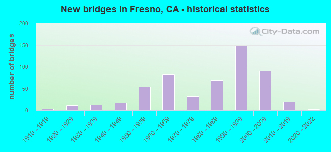
- New bridges - historical statistics
- 11900-1909
- 41910-1919
- 121920-1929
- 131930-1939
- 181940-1949
- 551950-1959
- 831960-1969
- 331970-1979
- 701980-1989
- 1491990-1999
- 912000-2009
- 202010-2019
- 22020-2022
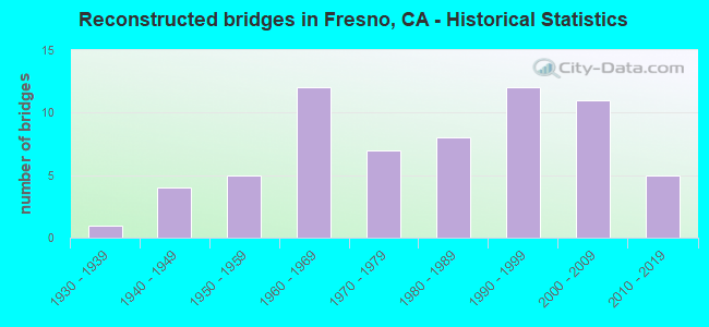
- Reconstructed bridges - Historical Statistics
- 11930-1939
- 41940-1949
- 51950-1959
- 121960-1969
- 71970-1979
- 81980-1989
- 121990-1999
- 112000-2009
- 52010-2019
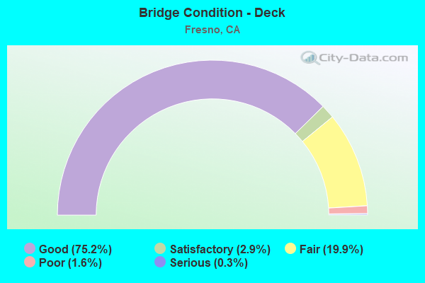
- Bridge Condition - Deck
- 75.2%Good
- 2.9%Satisfactory
- 19.9%Fair
- 1.6%Poor
- 0.3%Serious
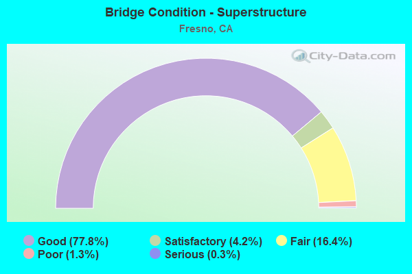
- Bridge Condition - Superstructure
- 77.8%Good
- 4.2%Satisfactory
- 16.4%Fair
- 1.3%Poor
- 0.3%Serious
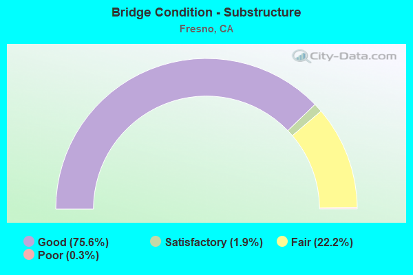
- Bridge Condition - Substructure
- 75.6%Good
- 1.9%Satisfactory
- 22.2%Fair
- 0.3%Poor
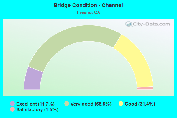
- Bridge Condition - Channel
- 11.7%Excellent
- 55.5%Very good
- 31.4%Good
- 1.5%Satisfactory
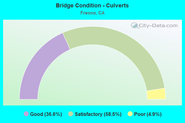
- Bridge Condition - Culverts
- 36.6%Good
- 58.5%Satisfactory
- 4.9%Poor
Find on map >> Show street view
Structure Number: 42 0312R, Location: 06-FRE-180-R56.41-FRE (Lat: 36.741528, Lng: -119.813081), Route carried "on" structure: State highway 180, Year Built: 2003, Status: Open, Structure Length: 4.89m (16.04ft), Average Daily Traffic: 8,000 (year 1999), Truck Traffic: 4%, Average Future Daily Traffic: 9,251 (year 2040), Design Load: HS 20+Mod, Features Intersected: N99-W180 CONNECTOR
Minimum Vertical Clearance: 30+ m (98+ ft), Kilometerpoint: 56.410, Lanes on structure: 2, Lanes under structure: 2, Base Highway Network: Yes (Inventory Route: 18, Subroute: 1), Owner: State Highway Agency, Approaching Roadway Width: 16.8m (55.1ft), Skew: 2 degrees, Material/Design: Prestressed concrete, Design/Construction: Box Beam or Girders - Multiple, Number Of Spans In Main Unit: 1, Length of Maximum Span: 48.9m (160.4ft), Curb-To-Curb Width: 16.8m (55.1ft), Out-to-Out Width: 17.9m (58.7ft)
Condition: Deck: Good, Superstructure: Good, Substructure: Good, Operating Rating: 54.1 metric tons, Method Used To Determine Operating Rating: Assigned rating based on Load Factor Design (LFD) reported in metric tons, Inventory Rating: 32.4 metric tons, Method Used To Determine Inventory Rating: Assigned rating based on Load Factor Design (LFD) reported in metric tons, Structural Evaluation: Better than present minimum criteria, Deck Geometry: Superior to present desirable criteria, Underclear: High priority of corrective action, Approach Roadway Alignment: Equal to present desirable criteria, Designated Inspection Frequency: Every 24 months, Inspection Date: January 2022, Deck Structure Type: Concrete Cast-file-Place
Find on map >> Show street view
Structure Number: 42 0313L, Location: 06-FRE-180-R56.66-FRE (Lat: 36.743881, Lng: -119.809364), Route carried "on" structure: State highway 180, Year Built: 1995, Status: Open, Structure Length: 5.97m (19.59ft), Average Daily Traffic: 49,500 (year 2009), Truck Traffic: 5%, Average Future Daily Traffic: 56,282 (year 2040), Design Load: HS 20+Mod, Features Intersected: G STREET
Minimum Vertical Clearance: 30+ m (98+ ft), Kilometerpoint: 56.660, Lanes on structure: 4, Lanes under structure: 5, Base Highway Network: Yes (Inventory Route: 18, Subroute: 1), Owner: State Highway Agency, Approaching Roadway Width: 20.7m (67.9ft), Skew: 3 degrees, Material/Design: Prestressed concrete continuous, Design/Construction: Box Beam or Girders - Multiple, Number Of Spans In Main Unit: 2, Length of Maximum Span: 32.4m (106.3ft), Curb-To-Curb Width: 20.7m (67.9ft), Out-to-Out Width: 21.7m (71.2ft)
Condition: Deck: Good, Superstructure: Good, Substructure: Good, Operating Rating: 54.1 metric tons, Method Used To Determine Operating Rating: Assigned rating based on Load Factor Design (LFD) reported in metric tons, Inventory Rating: 32.4 metric tons, Method Used To Determine Inventory Rating: Assigned rating based on Load Factor Design (LFD) reported in metric tons, Structural Evaluation: Better than present minimum criteria, Deck Geometry: Equal to present minimum criteria, Underclear: Somewhat better than minimum adequacy, Approach Roadway Alignment: Equal to present desirable criteria, Designated Inspection Frequency: Every 24 months, Inspection Date: December 2020, Deck Structure Type: Concrete Cast-file-Place
Find on map >> Show street view
Structure Number: 42 0313R, Location: 06-FRE-180-R56.67-FRE (Lat: 36.743700, Lng: -119.808856), Route carried "on" structure: State highway 180, Year Built: 1995, Status: Open, Structure Length: 5.99m (19.65ft), Average Daily Traffic: 49,500 (year 2009), Truck Traffic: 5%, Average Future Daily Traffic: 56,282 (year 2040), Design Load: HS 20+Mod, Features Intersected: G STREET
Minimum Vertical Clearance: 30+ m (98+ ft), Kilometerpoint: 56.670, Lanes on structure: 4, Lanes under structure: 4, Base Highway Network: Yes (Inventory Route: 18, Subroute: 1), Owner: State Highway Agency, Approaching Roadway Width: 24.4m (80.1ft), Skew: 3 degrees, Material/Design: Prestressed concrete continuous, Design/Construction: Box Beam or Girders - Multiple, Number Of Spans In Main Unit: 2, Length of Maximum Span: 31.7m (104.0ft), Curb-To-Curb Width: 26.3m (86.3ft), Out-to-Out Width: 27.3m (89.6ft)
Condition: Deck: Fair, Superstructure: Good, Substructure: Good, Operating Rating: 54.1 metric tons, Method Used To Determine Operating Rating: Assigned rating based on Load Factor Design (LFD) reported in metric tons, Inventory Rating: 32.4 metric tons, Method Used To Determine Inventory Rating: Assigned rating based on Load Factor Design (LFD) reported in metric tons, Structural Evaluation: Better than present minimum criteria, Deck Geometry: Superior to present desirable criteria, Underclear: Somewhat better than minimum adequacy, Approach Roadway Alignment: Equal to present desirable criteria, Designated Inspection Frequency: Every 24 months, Inspection Date: December 2020, Deck Structure Type: Concrete Cast-file-Place
Find on map >> Show street view
Structure Number: 42 0314L, Location: 06-FRE-180-R56.78-FRE (Lat: 36.744742, Lng: -119.807681), Route carried "on" structure: State highway 180, Year Built: 1995, Status: Open, Structure Length: 12.51m (41.04ft), Average Daily Traffic: 49,500 (year 2009), Truck Traffic: 5%, Average Future Daily Traffic: 56,282 (year 2040), Design Load: HS 20+Mod, Features Intersected: UP RR, SJVR, & H STREET
Minimum Vertical Clearance: 30+ m (98+ ft), Kilometerpoint: 56.780, Lanes on structure: 4, Lanes under structure: 4, Base Highway Network: Yes (Inventory Route: 18, Subroute: 1), Owner: State Highway Agency, Approaching Roadway Width: 20.7m (67.9ft), Material/Design: Prestressed concrete continuous, Design/Construction: Box Beam or Girders - Multiple, Number Of Spans In Main Unit: 2, Number Of Approach Spans: 1, Length of Maximum Span: 43.9m (144.0ft), Curb-To-Curb Width: 20.7m (67.9ft), Out-to-Out Width: 21.7m (71.2ft)
Condition: Deck: Good, Superstructure: Good, Substructure: Good, Operating Rating: 54.1 metric tons, Method Used To Determine Operating Rating: Assigned rating based on Load Factor Design (LFD) reported in metric tons, Inventory Rating: 32.4 metric tons, Method Used To Determine Inventory Rating: Assigned rating based on Load Factor Design (LFD) reported in metric tons, Structural Evaluation: Better than present minimum criteria, Deck Geometry: Equal to present minimum criteria, Underclear: Meets minimum limits, Approach Roadway Alignment: Equal to present desirable criteria, Designated Inspection Frequency: Every 24 months, Inspection Date: December 2020, Deck Structure Type: Concrete Cast-file-Place
Find on map >> Show street view
Structure Number: 42 0314R, Location: 06-FRE-180-R56.78-FRE (Lat: 36.744508, Lng: -119.807403), Route carried "on" structure: State highway 180, Year Built: 1995, Status: Open, Structure Length: 12.43m (40.78ft), Average Daily Traffic: 49,500 (year 2009), Truck Traffic: 5%, Average Future Daily Traffic: 56,282 (year 2040), Design Load: HS 20+Mod, Features Intersected: UP RR, SJVR, & H STREET
Minimum Vertical Clearance: 30+ m (98+ ft), Kilometerpoint: 56.780, Lanes on structure: 4, Lanes under structure: 3, Base Highway Network: Yes (Inventory Route: 18, Subroute: 1), Owner: State Highway Agency, Approaching Roadway Width: 24.4m (80.1ft), Material/Design: Prestressed concrete continuous, Design/Construction: Box Beam or Girders - Multiple, Number Of Spans In Main Unit: 2, Number Of Approach Spans: 1, Length of Maximum Span: 43.1m (141.4ft), Curb-To-Curb Width: 17.1m (56.1ft), Out-to-Out Width: 18.1m (59.4ft)
Condition: Deck: Good, Superstructure: Good, Substructure: Fair, Operating Rating: 54.1 metric tons, Method Used To Determine Operating Rating: Assigned rating based on Load Factor Design (LFD) reported in metric tons, Inventory Rating: 32.4 metric tons, Method Used To Determine Inventory Rating: Assigned rating based on Load Factor Design (LFD) reported in metric tons, Structural Evaluation: Somewhat better than minimum adequacy, Deck Geometry: Meets minimum limits, Underclear: Meets minimum limits, Approach Roadway Alignment: Equal to present desirable criteria, Designated Inspection Frequency: Every 24 months, Inspection Date: December 2020, Deck Structure Type: Concrete Cast-file-Place
Find on map >> Show street view
Structure Number: 42 0315L, Location: 06-FRE-180-R57.07-FRE (Lat: 36.747136, Lng: -119.803203), Route carried "on" structure: State highway 180, Year Built: 1995, Status: Open, Structure Length: 4.41m (14.47ft), Average Daily Traffic: 49,500 (year 2009), Truck Traffic: 5%, Average Future Daily Traffic: 56,282 (year 2040), Design Load: HS 20+Mod, Features Intersected: BROADWAY
Minimum Vertical Clearance: 30+ m (98+ ft), Kilometerpoint: 57.070, Lanes on structure: 4, Lanes under structure: 2, Base Highway Network: Yes (Inventory Route: 18, Subroute: 1), Owner: State Highway Agency, Approaching Roadway Width: 20.7m (67.9ft), Skew: 13 degrees, Material/Design: Prestressed concrete, Design/Construction: Box Beam or Girders - Multiple, Number Of Spans In Main Unit: 1, Length of Maximum Span: 43.3m (142.1ft), Curb-To-Curb Width: 17.7m (58.1ft), Out-to-Out Width: 21.9m (71.9ft)
Condition: Deck: Good, Superstructure: Fair, Substructure: Good, Operating Rating: 54.1 metric tons, Method Used To Determine Operating Rating: Assigned rating based on Load Factor Design (LFD) reported in metric tons, Inventory Rating: 32.4 metric tons, Method Used To Determine Inventory Rating: Assigned rating based on Load Factor Design (LFD) reported in metric tons, Structural Evaluation: Somewhat better than minimum adequacy, Deck Geometry: Meets minimum limits, Underclear: Equal to present desirable criteria, Approach Roadway Alignment: Equal to present desirable criteria, Designated Inspection Frequency: Every 24 months, Inspection Date: December 2020, Deck Structure Type: Concrete Cast-file-Place
Find on map >> Show street view
Structure Number: 42 0315R, Location: 06-FRE-180-R57.07-FRE (Lat: 36.746756, Lng: -119.803203), Route carried "on" structure: State highway 180, Year Built: 1995, Status: Open, Structure Length: 4.41m (14.47ft), Average Daily Traffic: 49,500 (year 2009), Truck Traffic: 5%, Average Future Daily Traffic: 56,282 (year 2040), Design Load: HS 20+Mod, Features Intersected: BROADWAY
Minimum Vertical Clearance: 30+ m (98+ ft), Kilometerpoint: 57.070, Lanes on structure: 4, Lanes under structure: 2, Base Highway Network: Yes (Inventory Route: 18, Subroute: 1), Owner: State Highway Agency, Approaching Roadway Width: 20.7m (67.9ft), Skew: 13 degrees, Material/Design: Prestressed concrete, Design/Construction: Box Beam or Girders - Multiple, Number Of Spans In Main Unit: 1, Length of Maximum Span: 43.9m (144.0ft), Curb-To-Curb Width: 20.1m (65.9ft), Out-to-Out Width: 21.2m (69.6ft)
Condition: Deck: Good, Superstructure: Good, Substructure: Good, Operating Rating: 54.1 metric tons, Method Used To Determine Operating Rating: Assigned rating based on Load Factor Design (LFD) reported in metric tons, Inventory Rating: 32.4 metric tons, Method Used To Determine Inventory Rating: Assigned rating based on Load Factor Design (LFD) reported in metric tons, Structural Evaluation: Better than present minimum criteria, Deck Geometry: Equal to present minimum criteria, Underclear: Equal to present desirable criteria, Approach Roadway Alignment: Equal to present desirable criteria, Designated Inspection Frequency: Every 24 months, Inspection Date: December 2020, Deck Structure Type: Concrete Cast-file-Place
Find on map >> Show street view
Structure Number: 42 0316K, Location: 06-FRE-180-R57.24-FRE (Lat: 36.748856, Lng: -119.800614), Route carried "on" structure: Ramp State highway 180, Year Built: 1995, Status: Open, Structure Length: 4.69m (15.39ft), Average Daily Traffic: 101 (year 2013), Truck Traffic: 15%, Average Future Daily Traffic: 116 (year 2043), Design Load: HS 20+Mod, Features Intersected: FULTON STREET
Minimum Vertical Clearance: 30+ m (98+ ft), Kilometerpoint: 57.240, Lanes on structure: 1, Lanes under structure: 3, Base Highway Network: Yes (Inventory Route: 1, Subroute: 1), Owner: State Highway Agency, Approaching Roadway Width: 7.3m (24.0ft), Skew: 2 degrees, Material/Design: Prestressed concrete, Design/Construction: Box Beam or Girders - Multiple, Number Of Spans In Main Unit: 1, Length of Maximum Span: 45.3m (148.6ft), Curb-To-Curb Width: 7.3m (24.0ft), Out-to-Out Width: 8.3m (27.2ft)
Condition: Deck: Good, Superstructure: Good, Substructure: Good, Operating Rating: 54.1 metric tons, Method Used To Determine Operating Rating: Assigned rating based on Load Factor Design (LFD) reported in metric tons, Inventory Rating: 32.4 metric tons, Method Used To Determine Inventory Rating: Assigned rating based on Load Factor Design (LFD) reported in metric tons, Structural Evaluation: Better than present minimum criteria, Deck Geometry: Better than present minimum criteria, Underclear: Meets minimum limits, Approach Roadway Alignment: Equal to present desirable criteria, Designated Inspection Frequency: Every 24 months, Inspection Date: January 2021, Deck Structure Type: Concrete Cast-file-Place
Find on map >> Show street view
Structure Number: 42 0316L, Location: 06-FRE-180-R57.24-FRE (Lat: 36.748525, Lng: -119.800611), Route carried "on" structure: State highway 180, Year Built: 1995, Status: Open, Structure Length: 4.95m (16.24ft), Average Daily Traffic: 49,500 (year 2009), Truck Traffic: 5%, Average Future Daily Traffic: 56,296 (year 2043), Design Load: HS 20+Mod, Features Intersected: FULTON STREET
Minimum Vertical Clearance: 30+ m (98+ ft), Kilometerpoint: 57.240, Lanes on structure: 3, Lanes under structure: 3, Base Highway Network: Yes (Inventory Route: 18, Subroute: 1), Owner: State Highway Agency, Approaching Roadway Width: 17.0m (55.8ft), Skew: 3 degrees, Material/Design: Prestressed concrete, Design/Construction: Box Beam or Girders - Multiple, Number Of Spans In Main Unit: 1, Length of Maximum Span: 48.1m (157.8ft), Curb-To-Curb Width: 17.0m (55.8ft), Out-to-Out Width: 18.1m (59.4ft)
Condition: Deck: Satisfactory, Superstructure: Good, Substructure: Good, Operating Rating: 54.1 metric tons, Method Used To Determine Operating Rating: Assigned rating based on Load Factor Design (LFD) reported in metric tons, Inventory Rating: 32.4 metric tons, Method Used To Determine Inventory Rating: Assigned rating based on Load Factor Design (LFD) reported in metric tons, Structural Evaluation: Better than present minimum criteria, Deck Geometry: Equal to present minimum criteria, Underclear: Meets minimum limits, Approach Roadway Alignment: Equal to present desirable criteria, Designated Inspection Frequency: Every 24 months, Inspection Date: January 2021, Deck Structure Type: Concrete Cast-file-Place
Find on map >> Show street view
Structure Number: 42 0316R, Location: 06-FRE-180-R57.24-FRE (Lat: 36.748214, Lng: -119.800597), Route carried "on" structure: State highway 180, Year Built: 1995, Status: Open, Structure Length: 4.87m (15.98ft), Average Daily Traffic: 49,500 (year 2009), Truck Traffic: 5%, Average Future Daily Traffic: 56,296 (year 2043), Design Load: HS 20+Mod, Features Intersected: FULTON STREET
Minimum Vertical Clearance: 30+ m (98+ ft), Kilometerpoint: 57.240, Lanes on structure: 3, Lanes under structure: 3, Base Highway Network: Yes (Inventory Route: 18, Subroute: 1), Owner: State Highway Agency, Approaching Roadway Width: 17.0m (55.8ft), Skew: 3 degrees, Material/Design: Prestressed concrete, Design/Construction: Box Beam or Girders - Multiple, Number Of Spans In Main Unit: 1, Length of Maximum Span: 47.3m (155.2ft), Curb-To-Curb Width: 17.0m (55.8ft), Out-to-Out Width: 18.1m (59.4ft)
Condition: Deck: Good, Superstructure: Good, Substructure: Good, Operating Rating: 54.1 metric tons, Method Used To Determine Operating Rating: Assigned rating based on Load Factor Design (LFD) reported in metric tons, Inventory Rating: 32.4 metric tons, Method Used To Determine Inventory Rating: Assigned rating based on Load Factor Design (LFD) reported in metric tons, Structural Evaluation: Better than present minimum criteria, Deck Geometry: Equal to present minimum criteria, Underclear: Meets minimum limits, Approach Roadway Alignment: Equal to present desirable criteria, Designated Inspection Frequency: Every 24 months, Inspection Date: January 2021, Deck Structure Type: Concrete Cast-file-Place
Find on map >> Show street view
Structure Number: 42 0317L, Location: 06-FRE-180-R57.34-FRE (Lat: 36.749325, Lng: -119.799125), Route carried "on" structure: State highway 180, Year Built: 1995, Status: Open, Structure Length: 4.60m (15.09ft), Average Daily Traffic: 49,500 (year 2009), Truck Traffic: 5%, Average Future Daily Traffic: 56,296 (year 2043), Design Load: HS 20+Mod, Features Intersected: VAN NESS AVE
Minimum Vertical Clearance: 30+ m (98+ ft), Kilometerpoint: 57.340, Lanes on structure: 4, Lanes under structure: 2, Base Highway Network: Yes (Inventory Route: 18, Subroute: 1), Owner: State Highway Agency, Approaching Roadway Width: 17.1m (56.1ft), Skew: 13 degrees, Material/Design: Prestressed concrete, Design/Construction: Box Beam or Girders - Multiple, Number Of Spans In Main Unit: 1, Length of Maximum Span: 44.6m (146.3ft), Curb-To-Curb Width: 21.5m (70.5ft), Out-to-Out Width: 22.5m (73.8ft)
Condition: Deck: Good, Superstructure: Good, Substructure: Fair, Operating Rating: 54.1 metric tons, Method Used To Determine Operating Rating: Assigned rating based on Load Factor Design (LFD) reported in metric tons, Inventory Rating: 32.4 metric tons, Method Used To Determine Inventory Rating: Assigned rating based on Load Factor Design (LFD) reported in metric tons, Structural Evaluation: Somewhat better than minimum adequacy, Deck Geometry: Better than present minimum criteria, Underclear: Meets minimum limits, Approach Roadway Alignment: Equal to present desirable criteria, Designated Inspection Frequency: Every 24 months, Inspection Date: January 2021, Deck Structure Type: Concrete Cast-file-Place
Find on map >> Show street view
Structure Number: 42 0317R, Location: 06-FRE-180-R57.34-FRE (Lat: 36.749008, Lng: -119.799117), Route carried "on" structure: State highway 180, Year Built: 1995, Status: Open, Structure Length: 4.53m (14.86ft), Average Daily Traffic: 49,500 (year 2009), Truck Traffic: 5%, Average Future Daily Traffic: 56,296 (year 2043), Design Load: HS 20+Mod, Features Intersected: VAN NESS AVE
Minimum Vertical Clearance: 30+ m (98+ ft), Kilometerpoint: 57.340, Lanes on structure: 3, Lanes under structure: 2, Base Highway Network: Yes (Inventory Route: 18, Subroute: 1), Owner: State Highway Agency, Approaching Roadway Width: 17.0m (55.8ft), Skew: 13 degrees, Material/Design: Prestressed concrete, Design/Construction: Box Beam or Girders - Multiple, Number Of Spans In Main Unit: 1, Length of Maximum Span: 45.3m (148.6ft), Curb-To-Curb Width: 17.0m (55.8ft), Out-to-Out Width: 18.1m (59.4ft)
Condition: Deck: Satisfactory, Superstructure: Good, Substructure: Good, Operating Rating: 54.1 metric tons, Method Used To Determine Operating Rating: Assigned rating based on Load Factor Design (LFD) reported in metric tons, Inventory Rating: 32.4 metric tons, Method Used To Determine Inventory Rating: Assigned rating based on Load Factor Design (LFD) reported in metric tons, Structural Evaluation: Better than present minimum criteria, Deck Geometry: Equal to present minimum criteria, Underclear: Meets minimum limits, Approach Roadway Alignment: Equal to present desirable criteria, Designated Inspection Frequency: Every 24 months, Inspection Date: January 2021, Deck Structure Type: Concrete Cast-file-Place
Find on map >> Show street view
Structure Number: 42 0318L, Location: 06-FRE-180-R57.45-FRE (Lat: 36.750125, Lng: -119.797514), Route carried "on" structure: State highway 180, Year Built: 1995, Status: Open, Structure Length: 26.18m (85.89ft), Average Daily Traffic: 49,500 (year 2009), Truck Traffic: 5%, Average Future Daily Traffic: 56,296 (year 2043), Design Load: HS 20+Mod, Features Intersected: BELMONT AV, SAN PABLO AV
Minimum Vertical Clearance: 30+ m (98+ ft), Kilometerpoint: 57.450, Lanes on structure: 4, Lanes under structure: 6, Base Highway Network: Yes (Inventory Route: 18, Subroute: 1), Owner: State Highway Agency, Approaching Roadway Width: 20.7m (67.9ft), Skew: 9 degrees, Material/Design: Prestressed concrete continuous, Design/Construction: Box Beam or Girders - Multiple, Number Of Spans In Main Unit: 7, Length of Maximum Span: 40.8m (133.9ft), Curb-To-Curb Width: 20.7m (67.9ft), Out-to-Out Width: 21.7m (71.2ft)
Condition: Deck: Good, Superstructure: Good, Substructure: Good, Operating Rating: 54.1 metric tons, Method Used To Determine Operating Rating: Assigned rating based on Load Factor Design (LFD) reported in metric tons, Inventory Rating: 32.4 metric tons, Method Used To Determine Inventory Rating: Assigned rating based on Load Factor Design (LFD) reported in metric tons, Structural Evaluation: Better than present minimum criteria, Deck Geometry: Equal to present minimum criteria, Underclear: Equal to present minimum criteria, Approach Roadway Alignment: Equal to present desirable criteria, Designated Inspection Frequency: Every 24 months, Inspection Date: January 2021, Deck Structure Type: Concrete Cast-file-Place
Find on map >> Show street view
Structure Number: 42 0318R, Location: 06-FRE-180-R57.45-FRE (Lat: 36.749850, Lng: -119.797125), Route carried "on" structure: State highway 180, Year Built: 1995, Status: Open, Structure Length: 24.70m (81.04ft), Average Daily Traffic: 49,500 (year 2009), Truck Traffic: 5%, Average Future Daily Traffic: 56,296 (year 2043), Design Load: HS 20+Mod, Features Intersected: BELMONT, PARK, SAN PABLO
Minimum Vertical Clearance: 30+ m (98+ ft), Kilometerpoint: 57.450, Lanes on structure: 4, Lanes under structure: 8, Base Highway Network: Yes (Inventory Route: 18, Subroute: 1), Owner: State Highway Agency, Approaching Roadway Width: 20.7m (67.9ft), Skew: 9 degrees, Material/Design: Prestressed concrete continuous, Design/Construction: Box Beam or Girders - Multiple, Number Of Spans In Main Unit: 7, Length of Maximum Span: 42.2m (138.5ft), Curb-To-Curb Width: 21.8m (71.5ft), Out-to-Out Width: 22.8m (74.8ft)
Condition: Deck: Satisfactory, Superstructure: Good, Substructure: Good, Operating Rating: 54.1 metric tons, Method Used To Determine Operating Rating: Assigned rating based on Load Factor Design (LFD) reported in metric tons, Inventory Rating: 32.4 metric tons, Method Used To Determine Inventory Rating: Assigned rating based on Load Factor Design (LFD) reported in metric tons, Structural Evaluation: Better than present minimum criteria, Deck Geometry: Better than present minimum criteria, Underclear: Meets minimum limits, Approach Roadway Alignment: Equal to present desirable criteria, Designated Inspection Frequency: Every 24 months, Inspection Date: January 2021, Deck Structure Type: Concrete Cast-file-Place
Find on map >> Show street view
Structure Number: 42 0319K, Location: 06-FRE-180-R57.84-FRE (Lat: 36.752222, Lng: -119.790744), Route carried "on" structure: Ramp State highway 180, Year Built: 1980, Status: Open, Structure Length: 3.59m (11.78ft), Average Daily Traffic: 12,000 (year 2013), Truck Traffic: 2%, Average Future Daily Traffic: 25,079 (year 2041), Design Load: HS 20+Mod, Features Intersected: BLACKSTONE AVE
Minimum Vertical Clearance: 30+ m (98+ ft), Kilometerpoint: 57.840, Lanes on structure: 1, Lanes under structure: 3, Base Highway Network: Yes (Inventory Route: 1, Subroute: 1), Owner: State Highway Agency, Approaching Roadway Width: 7.3m (24.0ft), Skew: 1 degrees, Material/Design: Prestressed concrete, Design/Construction: Box Beam or Girders - Multiple, Number Of Spans In Main Unit: 1, Length of Maximum Span: 35.8m (117.5ft), Curb-To-Curb Width: 7.3m (24.0ft), Out-to-Out Width: 8.4m (27.6ft)
Condition: Deck: Good, Superstructure: Good, Substructure: Good, Operating Rating: 54.1 metric tons, Method Used To Determine Operating Rating: Assigned rating based on Load Factor Design (LFD) reported in metric tons, Inventory Rating: 32.4 metric tons, Method Used To Determine Inventory Rating: Assigned rating based on Load Factor Design (LFD) reported in metric tons, Structural Evaluation: Better than present minimum criteria, Deck Geometry: Better than present minimum criteria, Underclear: Equal to present minimum criteria, Approach Roadway Alignment: Equal to present desirable criteria, Designated Inspection Frequency: Every 24 months, Inspection Date: January 2021, Deck Structure Type: Concrete Cast-file-Place, Wearing Surface/Protective System: Wearing Surface: Bituminous
Find on map >> Show street view
Structure Number: 42 0319L, Location: 06-FRE-180-R57.84-FRE (Lat: 36.751981, Lng: -119.790756), Route carried "on" structure: State highway 180, Year Built: 1995, Status: Open, Structure Length: 3.93m (12.89ft), Average Daily Traffic: 49,500 (year 2009), Truck Traffic: 5%, Average Future Daily Traffic: 56,296 (year 2043), Design Load: HS 20+Mod, Features Intersected: BLACKSTONE AVE
Minimum Vertical Clearance: 30+ m (98+ ft), Kilometerpoint: 57.840, Lanes on structure: 3, Lanes under structure: 3, Base Highway Network: Yes (Inventory Route: 18, Subroute: 1), Owner: State Highway Agency, Approaching Roadway Width: 17.0m (55.8ft), Skew: 1 degrees, Material/Design: Prestressed concrete, Design/Construction: Box Beam or Girders - Multiple, Number Of Spans In Main Unit: 1, Length of Maximum Span: 37.8m (124.0ft), Curb-To-Curb Width: 17.0m (55.8ft), Out-to-Out Width: 18.1m (59.4ft)
Condition: Deck: Good, Superstructure: Good, Substructure: Good, Operating Rating: 54.1 metric tons, Method Used To Determine Operating Rating: Assigned rating based on Load Factor Design (LFD) reported in metric tons, Inventory Rating: 32.4 metric tons, Method Used To Determine Inventory Rating: Assigned rating based on Load Factor Design (LFD) reported in metric tons, Structural Evaluation: Better than present minimum criteria, Deck Geometry: Equal to present minimum criteria, Underclear: Equal to present minimum criteria, Approach Roadway Alignment: Equal to present desirable criteria, Designated Inspection Frequency: Every 24 months, Inspection Date: January 2021, Deck Structure Type: Concrete Cast-file-Place
Find on map >> Show street view
Structure Number: 42 0319R, Location: 06-FRE-180-R57.84-FRE (Lat: 36.751675, Lng: -119.790747), Route carried "on" structure: State highway 180, Year Built: 1995, Status: Open, Structure Length: 3.93m (12.89ft), Average Daily Traffic: 49,500 (year 2009), Truck Traffic: 5%, Average Future Daily Traffic: 56,296 (year 2043), Design Load: HS 20+Mod, Features Intersected: BLACKSTONE AVE
Minimum Vertical Clearance: 30+ m (98+ ft), Kilometerpoint: 57.840, Lanes on structure: 4, Lanes under structure: 3, Base Highway Network: Yes (Inventory Route: 18, Subroute: 1), Owner: State Highway Agency, Approaching Roadway Width: 17.1m (56.1ft), Skew: 1 degrees, Material/Design: Prestressed concrete, Design/Construction: Box Beam or Girders - Multiple, Number Of Spans In Main Unit: 1, Length of Maximum Span: 37.8m (124.0ft), Curb-To-Curb Width: 20.6m (67.6ft), Out-to-Out Width: 21.6m (70.9ft)
Condition: Deck: Good, Superstructure: Fair, Substructure: Good, Operating Rating: 54.1 metric tons, Method Used To Determine Operating Rating: Assigned rating based on Load Factor Design (LFD) reported in metric tons, Inventory Rating: 32.4 metric tons, Method Used To Determine Inventory Rating: Assigned rating based on Load Factor Design (LFD) reported in metric tons, Structural Evaluation: Somewhat better than minimum adequacy, Deck Geometry: Equal to present minimum criteria, Underclear: Equal to present minimum criteria, Approach Roadway Alignment: Equal to present desirable criteria, Designated Inspection Frequency: Every 24 months, Inspection Date: January 2021, Deck Structure Type: Concrete Cast-file-Place
Find on map >> Show street view
Structure Number: 42 0320L, Location: 06-FRE-180-R57.92-FRE (Lat: 36.752231, Lng: -119.789581), Route carried "on" structure: State highway 180, Year Built: 1980, Year Reconstructed: 1995, Status: Open, Structure Length: 4.05m (13.29ft), Average Daily Traffic: 49,500 (year 2009), Truck Traffic: 5%, Average Future Daily Traffic: 56,296 (year 2043), Design Load: HS 20+Mod, Features Intersected: ABBY STREET
Minimum Vertical Clearance: 30+ m (98+ ft), Kilometerpoint: 57.920, Lanes on structure: 4, Lanes under structure: 3, Base Highway Network: Yes (Inventory Route: 18, Subroute: 1), Owner: State Highway Agency, Approaching Roadway Width: 17.1m (56.1ft), Skew: 1 degrees, Material/Design: Prestressed concrete, Design/Construction: Box Beam or Girders - Multiple, Number Of Spans In Main Unit: 1, Length of Maximum Span: 40.5m (132.9ft), Curb-To-Curb Width: 20.7m (67.9ft), Out-to-Out Width: 21.8m (71.5ft)
Condition: Deck: Good, Superstructure: Good, Substructure: Good, Operating Rating: 54.1 metric tons, Method Used To Determine Operating Rating: Assigned rating based on Load Factor Design (LFD) reported in metric tons, Inventory Rating: 32.4 metric tons, Method Used To Determine Inventory Rating: Assigned rating based on Load Factor Design (LFD) reported in metric tons, Structural Evaluation: Better than present minimum criteria, Deck Geometry: Equal to present minimum criteria, Underclear: Somewhat better than minimum adequacy, Approach Roadway Alignment: Equal to present desirable criteria, Designated Inspection Frequency: Every 24 months, Inspection Date: January 2021, Deck Structure Type: Concrete Cast-file-Place
Find on map >> Show street view
Structure Number: 42 0320R, Location: 06-FRE-180-R57.92-FRE (Lat: 36.751975, Lng: -119.789503), Route carried "on" structure: State highway 180, Year Built: 1995, Status: Open, Structure Length: 4.16m (13.65ft), Average Daily Traffic: 49,500 (year 2009), Truck Traffic: 5%, Average Future Daily Traffic: 56,296 (year 2043), Design Load: HS 20+Mod, Features Intersected: ABBY STREET
Minimum Vertical Clearance: 30+ m (98+ ft), Kilometerpoint: 57.920, Lanes on structure: 3, Lanes under structure: 3, Base Highway Network: Yes (Inventory Route: 18, Subroute: 1), Owner: State Highway Agency, Approaching Roadway Width: 17.1m (56.1ft), Skew: 1 degrees, Material/Design: Prestressed concrete, Design/Construction: Box Beam or Girders - Multiple, Number Of Spans In Main Unit: 1, Length of Maximum Span: 41.6m (136.5ft), Curb-To-Curb Width: 17.1m (56.1ft), Out-to-Out Width: 18.1m (59.4ft)
Condition: Deck: Good, Superstructure: Good, Substructure: Good, Operating Rating: 54.1 metric tons, Method Used To Determine Operating Rating: Assigned rating based on Load Factor Design (LFD) reported in metric tons, Inventory Rating: 32.4 metric tons, Method Used To Determine Inventory Rating: Assigned rating based on Load Factor Design (LFD) reported in metric tons, Structural Evaluation: Better than present minimum criteria, Deck Geometry: Equal to present minimum criteria, Underclear: Somewhat better than minimum adequacy, Approach Roadway Alignment: Equal to present desirable criteria, Designated Inspection Frequency: Every 24 months, Inspection Date: January 2021, Deck Structure Type: Concrete Cast-file-Place
Find on map >> Show street view
Structure Number: 42 0320S, Location: 06-FRE-180-R57.92-FRE (Lat: 36.751858, Lng: -119.789483), Route carried "on" structure: Ramp State highway 180, Year Built: 1995, Status: Open, Structure Length: 3.90m (12.80ft), Average Daily Traffic: 195 (year 2013), Truck Traffic: 15%, Average Future Daily Traffic: 326 (year 2043), Design Load: HS 20+Mod, Features Intersected: ABBY STREET
Minimum Vertical Clearance: 30+ m (98+ ft), Kilometerpoint: 57.920, Lanes on structure: 1, Lanes under structure: 3, Base Highway Network: Yes (Inventory Route: 1, Subroute: 1), Owner: State Highway Agency, Approaching Roadway Width: 7.3m (24.0ft), Skew: 1 degrees, Material/Design: Prestressed concrete, Design/Construction: Box Beam or Girders - Multiple, Number Of Spans In Main Unit: 1, Length of Maximum Span: 39.0m (128.0ft), Curb-To-Curb Width: 7.3m (24.0ft), Out-to-Out Width: 8.4m (27.6ft)
Condition: Deck: Good, Superstructure: Good, Substructure: Good, Operating Rating: 54.1 metric tons, Method Used To Determine Operating Rating: Assigned rating based on Load Factor Design (LFD) reported in metric tons, Inventory Rating: 32.4 metric tons, Method Used To Determine Inventory Rating: Assigned rating based on Load Factor Design (LFD) reported in metric tons, Structural Evaluation: Better than present minimum criteria, Deck Geometry: Better than present minimum criteria, Underclear: Somewhat better than minimum adequacy, Approach Roadway Alignment: Equal to present desirable criteria, Designated Inspection Frequency: Every 24 months, Inspection Date: January 2021, Deck Structure Type: Concrete Cast-file-Place
Find on map >> Show street view
Structure Number: 42 0321L, Location: 06-FRE-180-R58.04-FRE (Lat: 36.752703, Lng: -119.787367), Route carried "on" structure: State highway 180, Year Built: 1980, Year Reconstructed: 1995, Status: Open, Structure Length: 3.72m (12.20ft), Average Daily Traffic: 49,500 (year 2016), Truck Traffic: 5%, Average Future Daily Traffic: 138,071 (year 2042), Design Load: HS 20+Mod, Features Intersected: BNSF RY & AMTRAK
Minimum Vertical Clearance: 30+ m (98+ ft), Kilometerpoint: 58.040, Lanes on structure: 4, Base Highway Network: Yes (Inventory Route: 18, Subroute: 1), Owner: State Highway Agency, Approaching Roadway Width: 21.3m (69.9ft), Skew: 1 degrees, Material/Design: Prestressed concrete continuous, Design/Construction: Slab, Number Of Spans In Main Unit: 3, Length of Maximum Span: 15.2m (49.9ft), Curb-To-Curb Width: 20.5m (67.3ft), Out-to-Out Width: 21.5m (70.5ft)
Condition: Deck: Satisfactory, Superstructure: Satisfactory, Substructure: Good, Operating Rating: 54.1 metric tons, Method Used To Determine Operating Rating: Assigned rating based on Load Factor Design (LFD) reported in metric tons, Inventory Rating: 32.4 metric tons, Method Used To Determine Inventory Rating: Assigned rating based on Load Factor Design (LFD) reported in metric tons, Structural Evaluation: Equal to present minimum criteria, Deck Geometry: Equal to present minimum criteria, Underclear: Equal to present minimum criteria, Approach Roadway Alignment: Equal to present desirable criteria, Designated Inspection Frequency: Every 48 months, Inspection Date: January 2022, Deck Structure Type: Concrete Cast-file-Place
Find on map >> Show street view
Structure Number: 42 0321R, Location: 06-FRE-180-R58.04-FRE (Lat: 36.752322, Lng: -119.787381), Route carried "on" structure: State highway 180, Year Built: 1980, Year Reconstructed: 1994, Status: Open, Structure Length: 3.72m (12.20ft), Average Daily Traffic: 49,500 (year 2016), Truck Traffic: 5%, Average Future Daily Traffic: 138,071 (year 2042), Design Load: HS 20+Mod, Features Intersected: BNSF RY & AMTRAK
Minimum Vertical Clearance: 30+ m (98+ ft), Kilometerpoint: 58.040, Lanes on structure: 4, Base Highway Network: Yes (Inventory Route: 18, Subroute: 1), Owner: State Highway Agency, Approaching Roadway Width: 23.2m (76.1ft), Skew: 1 degrees, Material/Design: Prestressed concrete continuous, Design/Construction: Slab, Number Of Spans In Main Unit: 3, Length of Maximum Span: 15.2m (49.9ft), Curb-To-Curb Width: 23.4m (76.8ft), Out-to-Out Width: 25.9m (85.0ft)
Condition: Deck: Fair, Superstructure: Fair, Substructure: Fair, Operating Rating: 54.1 metric tons, Method Used To Determine Operating Rating: Assigned rating based on Load Factor Design (LFD) reported in metric tons, Inventory Rating: 32.4 metric tons, Method Used To Determine Inventory Rating: Assigned rating based on Load Factor Design (LFD) reported in metric tons, Structural Evaluation: Somewhat better than minimum adequacy, Deck Geometry: Superior to present desirable criteria, Underclear: Equal to present minimum criteria, Approach Roadway Alignment: Equal to present desirable criteria, Designated Inspection Frequency: Every 24 months, Inspection Date: January 2022, Deck Structure Type: Concrete Cast-file-Place
Find on map >> Show street view
Structure Number: 42 0322L, Location: 06-FRE-180-R58.36-FRE (Lat: 36.753675, Lng: -119.781708), Route carried "on" structure: State highway 180, Year Built: 1980, Year Reconstructed: 1999, Status: Open, Structure Length: 4.27m (14.01ft), Average Daily Traffic: 49,500 (year 2009), Truck Traffic: 5%, Average Future Daily Traffic: 138,071 (year 2042), Design Load: HS 20+Mod, Features Intersected: FRESNO STREET
Minimum Vertical Clearance: 30+ m (98+ ft), Kilometerpoint: 58.360, Lanes on structure: 4, Lanes under structure: 4, Base Highway Network: Yes (Inventory Route: 18, Subroute: 1), Owner: State Highway Agency, Approaching Roadway Width: 20.5m (67.3ft), Skew: 1 degrees, Material/Design: Prestressed concrete, Design/Construction: Box Beam or Girders - Multiple, Number Of Spans In Main Unit: 1, Length of Maximum Span: 42.4m (139.1ft), Curb-To-Curb Width: 20.5m (67.3ft), Out-to-Out Width: 21.6m (70.9ft)
Condition: Deck: Good, Superstructure: Good, Substructure: Good, Operating Rating: 54.1 metric tons, Method Used To Determine Operating Rating: Assigned rating based on Load Factor Design (LFD) reported in metric tons, Inventory Rating: 32.4 metric tons, Method Used To Determine Inventory Rating: Assigned rating based on Load Factor Design (LFD) reported in metric tons, Structural Evaluation: Better than present minimum criteria, Deck Geometry: Equal to present minimum criteria, Underclear: Equal to present minimum criteria, Approach Roadway Alignment: Equal to present desirable criteria, Designated Inspection Frequency: Every 24 months, Inspection Date: January 2022, Deck Structure Type: Concrete Cast-file-Place
Find on map >> Show street view
Structure Number: 42 0322R, Location: 06-FRE-180-R58.36-FRE (Lat: 36.753342, Lng: -119.781706), Route carried "on" structure: State highway 180, Year Built: 1980, Year Reconstructed: 1999, Status: Open, Structure Length: 4.27m (14.01ft), Average Daily Traffic: 49,500 (year 2009), Truck Traffic: 5%, Average Future Daily Traffic: 138,071 (year 2042), Design Load: HS 20+Mod, Features Intersected: FRESNO STREET
Minimum Vertical Clearance: 30+ m (98+ ft), Kilometerpoint: 58.360, Lanes on structure: 5, Lanes under structure: 4, Base Highway Network: Yes (Inventory Route: 18, Subroute: 1), Owner: State Highway Agency, Approaching Roadway Width: 25.4m (83.3ft), Skew: 1 degrees, Material/Design: Prestressed concrete, Design/Construction: Box Beam or Girders - Multiple, Number Of Spans In Main Unit: 1, Length of Maximum Span: 42.4m (139.1ft), Curb-To-Curb Width: 24.3m (79.7ft), Out-to-Out Width: 26.0m (85.3ft)
Condition: Deck: Good, Superstructure: Good, Substructure: Good, Operating Rating: 54.1 metric tons, Method Used To Determine Operating Rating: Assigned rating based on Load Factor Design (LFD) reported in metric tons, Inventory Rating: 32.4 metric tons, Method Used To Determine Inventory Rating: Assigned rating based on Load Factor Design (LFD) reported in metric tons, Structural Evaluation: Better than present minimum criteria, Deck Geometry: Equal to present minimum criteria, Underclear: Equal to present minimum criteria, Approach Roadway Alignment: Equal to present desirable criteria, Designated Inspection Frequency: Every 24 months, Inspection Date: January 2022, Deck Structure Type: Concrete Cast-file-Place
Find on map >> Show street view
Structure Number: 42 0323J, Location: 06-FRE-180-R58.87-FRE (Lat: 36.755306, Lng: -119.772878), Route carried "on" structure: Ramp State highway 180, Year Built: 1999, Status: Open, Structure Length: 5.36m (17.59ft), Average Daily Traffic: 20,000 (year 2016), Truck Traffic: 5%, Average Future Daily Traffic: 32,821 (year 2042), Design Load: HS 20+Mod, Features Intersected: FIRST STREET
Minimum Vertical Clearance: 30+ m (98+ ft), Kilometerpoint: 58.870, Lanes on structure: 2, Lanes under structure: 6, Base Highway Network: Yes, Owner: State Highway Agency, Approaching Roadway Width: 11.9m (39.0ft), Material/Design: Concrete continuous, Design/Construction: Box Beam or Girders - Multiple, Number Of Spans In Main Unit: 2, Length of Maximum Span: 26.8m (87.9ft), Curb-To-Curb Width: 11.9m (39.0ft), Out-to-Out Width: 13.0m (42.7ft)
Condition: Deck: Good, Superstructure: Good, Substructure: Good, Operating Rating: 54.1 metric tons, Method Used To Determine Operating Rating: Assigned rating based on Load Factor Design (LFD) reported in metric tons, Inventory Rating: 32.4 metric tons, Method Used To Determine Inventory Rating: Assigned rating based on Load Factor Design (LFD) reported in metric tons, Structural Evaluation: Better than present minimum criteria, Deck Geometry: Superior to present desirable criteria, Underclear: Equal to present minimum criteria, Approach Roadway Alignment: Equal to present desirable criteria, Designated Inspection Frequency: Every 48 months, Inspection Date: January 2022, Deck Structure Type: Concrete Cast-file-Place
Find on map >> Show street view
Structure Number: 42 0323K, Location: 06-FRE-180-R58.87-FRE (Lat: 36.755033, Lng: -119.772772), Route carried "on" structure: Ramp State highway 180, Year Built: 1999, Status: Open, Structure Length: 5.36m (17.59ft), Average Daily Traffic: 11,250 (year 2016), Truck Traffic: 5%, Average Future Daily Traffic: 17,943 (year 2042), Design Load: HS 20+Mod, Features Intersected: FIRST STREET
Minimum Vertical Clearance: 30+ m (98+ ft), Kilometerpoint: 58.870, Lanes on structure: 2, Lanes under structure: 4, Base Highway Network: Yes, Owner: State Highway Agency, Approaching Roadway Width: 11.9m (39.0ft), Material/Design: Concrete continuous, Design/Construction: Box Beam or Girders - Multiple, Number Of Spans In Main Unit: 2, Length of Maximum Span: 26.8m (87.9ft), Curb-To-Curb Width: 11.9m (39.0ft), Out-to-Out Width: 13.0m (42.7ft)
Condition: Deck: Good, Superstructure: Good, Substructure: Good, Operating Rating: 54.1 metric tons, Method Used To Determine Operating Rating: Assigned rating based on Load Factor Design (LFD) reported in metric tons, Inventory Rating: 32.4 metric tons, Method Used To Determine Inventory Rating: Assigned rating based on Load Factor Design (LFD) reported in metric tons, Structural Evaluation: Better than present minimum criteria, Deck Geometry: Superior to present desirable criteria, Underclear: Meets minimum limits, Approach Roadway Alignment: Equal to present desirable criteria, Designated Inspection Frequency: Every 48 months, Inspection Date: January 2022, Deck Structure Type: Concrete Cast-file-Place
Find on map >> Show street view
Structure Number: 42 0323L, Location: 06-FRE-180-R58.86-FRE (Lat: 36.754775, Lng: -119.772758), Route carried "on" structure: State highway 180, Year Built: 1999, Status: Open, Structure Length: 5.06m (16.60ft), Average Daily Traffic: 79,000 (year 2016), Truck Traffic: 6%, Average Future Daily Traffic: 76,500 (year 2040), Design Load: HS 20+Mod, Features Intersected: FIRST STREET
Minimum Vertical Clearance: 30+ m (98+ ft), Kilometerpoint: 58.860, Lanes on structure: 3, Lanes under structure: 4, Base Highway Network: Yes (Inventory Route: 18, Subroute: 1), Owner: State Highway Agency, Approaching Roadway Width: 17.1m (56.1ft), Material/Design: Concrete continuous, Design/Construction: Box Beam or Girders - Multiple, Number Of Spans In Main Unit: 2, Length of Maximum Span: 25.3m (83.0ft), Curb-To-Curb Width: 17.1m (56.1ft), Out-to-Out Width: 18.1m (59.4ft)
Condition: Deck: Good, Superstructure: Satisfactory, Substructure: Good, Operating Rating: 54.1 metric tons, Method Used To Determine Operating Rating: Assigned rating based on Load Factor Design (LFD) reported in metric tons, Inventory Rating: 32.4 metric tons, Method Used To Determine Inventory Rating: Assigned rating based on Load Factor Design (LFD) reported in metric tons, Structural Evaluation: Equal to present minimum criteria, Deck Geometry: Equal to present minimum criteria, Underclear: Somewhat better than minimum adequacy, Approach Roadway Alignment: Equal to present desirable criteria, Designated Inspection Frequency: Every 24 months, Inspection Date: January 2022, Deck Structure Type: Concrete Cast-file-Place
Find on map >> Show street view
Structure Number: 42 0323R, Location: 06-FRE-180-R58.86-FRE (Lat: 36.754394, Lng: -119.772758), Route carried "on" structure: State highway 180, Year Built: 1999, Year Reconstructed: 2014, Status: Open, Structure Length: 5.06m (16.60ft), Average Daily Traffic: 79,000 (year 2016), Truck Traffic: 6%, Average Future Daily Traffic: 76,500 (year 2040), Design Load: HL 93, Features Intersected: FIRST STREET
Minimum Vertical Clearance: 30+ m (98+ ft), Kilometerpoint: 58.860, Lanes on structure: 5, Lanes under structure: 4, Base Highway Network: Yes (Inventory Route: 18, Subroute: 1), Owner: State Highway Agency, Approaching Roadway Width: 24.4m (80.1ft), Skew: 30 degrees, Material/Design: Concrete continuous, Design/Construction: Box Beam or Girders - Multiple, Number Of Spans In Main Unit: 2, Length of Maximum Span: 25.3m (83.0ft), Curb-To-Curb Width: 24.4m (80.1ft), Out-to-Out Width: 25.3m (83.0ft)
Condition: Deck: Good, Superstructure: Good, Substructure: Good, Operating Rating: 54.1 metric tons, Method Used To Determine Operating Rating: Field evaluation and documented engineering judgment, Inventory Rating: 32.4 metric tons, Method Used To Determine Inventory Rating: Field evaluation and documented engineering judgment, Structural Evaluation: Better than present minimum criteria, Deck Geometry: Equal to present minimum criteria, Approach Roadway Alignment: Equal to present desirable criteria, Designated Inspection Frequency: Every 48 months, Inspection Date: January 2022, Deck Structure Type: Concrete Cast-file-Place
Find on map >> Show street view
Structure Number: 42 0326, Location: 06-FRE-180-R59.88-FRE (Lat: 36.754272, Lng: -119.754233), Route carried "on" structure: City street , Year Built: 1999, Status: Open, Structure Length: 16.02m (52.56ft), Average Daily Traffic: 23,400 (year 2010), Truck Traffic: 3%, Average Future Daily Traffic: 41,318 (year 2042), Design Load: HS 20+Mod, Features Intersected: STATE ROUTE 180, Facility Carried by Structure: CEDAR AVENUE
Minimum Vertical Clearance: 30+ m (98+ ft), Kilometerpoint: 0.000, Lanes on structure: 9, Lanes under structure: 11, Base Highway Network: Yes, Owner: State Highway Agency, Approaching Roadway Width: 32.3m (106.0ft), Skew: 30 degrees, Material/Design: Prestressed concrete continuous, Design/Construction: Box Beam or Girders - Multiple, Number Of Spans In Main Unit: 4, Length of Maximum Span: 43.8m (143.7ft), Curb or Sidewalk Widths: Left: 2.1m (6.9ft), Right: 2.1m (6.9ft), Curb-To-Curb Width: 32.3m (106.0ft), Out-to-Out Width: 44.5m (146.0ft)
Condition: Deck: Good, Superstructure: Fair, Substructure: Good, Operating Rating: 54.1 metric tons, Method Used To Determine Operating Rating: Assigned rating based on Load Factor Design (LFD) reported in metric tons, Inventory Rating: 32.4 metric tons, Method Used To Determine Inventory Rating: Assigned rating based on Load Factor Design (LFD) reported in metric tons, Structural Evaluation: Somewhat better than minimum adequacy, Deck Geometry: High priority of corrective action, Underclear: Meets minimum limits, Approach Roadway Alignment: Equal to present desirable criteria, Designated Inspection Frequency: Every 24 months, Inspection Date: January 2022, Deck Structure Type: Concrete Cast-file-Place
Find on map >> Show street view
Structure Number: 42 0327G, Location: 06-FRE-180-R59.90-FRE (Lat: 36.754467, Lng: -119.752242), Route carried "on" structure: Ramp State highway 180, Year Built: 1999, Status: Open, Structure Length: 28.70m (94.16ft), Average Daily Traffic: 21,000 (year 2009), Truck Traffic: 3%, Average Future Daily Traffic: 35,706 (year 2042), Design Load: HS 20+Mod, Features Intersected: STATE ROUTE 180 & RAMPS
Minimum Vertical Clearance: 30+ m (98+ ft), Kilometerpoint: 59.900, Lanes on structure: 2, Lanes under structure: 8, Owner: State Highway Agency, Approaching Roadway Width: 11.9m (39.0ft), Material/Design: Prestressed concrete continuous, Design/Construction: Box Beam or Girders - Multiple, Number Of Spans In Main Unit: 6, Length of Maximum Span: 57.5m (188.6ft), Curb-To-Curb Width: 11.9m (39.0ft), Out-to-Out Width: 13.0m (42.7ft)
Condition: Deck: Good, Superstructure: Good, Substructure: Good, Operating Rating: 54.1 metric tons, Method Used To Determine Operating Rating: Assigned rating based on Load Factor Design (LFD) reported in metric tons, Inventory Rating: 32.4 metric tons, Method Used To Determine Inventory Rating: Assigned rating based on Load Factor Design (LFD) reported in metric tons, Structural Evaluation: Better than present minimum criteria, Deck Geometry: Superior to present desirable criteria, Underclear: Somewhat better than minimum adequacy, Approach Roadway Alignment: Equal to present desirable criteria, Designated Inspection Frequency: Every 24 months, Inspection Date: January 2022, Deck Structure Type: Concrete Cast-file-Place
Find on map >> Show street view
Structure Number: 42 0328G, Location: 06-FRE-180-R60.10-FRE (Lat: 36.757544, Lng: -119.749050), Route carried "on" structure: Ramp State highway 180, Year Built: 1999, Status: Open, Structure Length: 4.18m (13.71ft), Average Daily Traffic: 21,000 (year 2009), Truck Traffic: 4%, Average Future Daily Traffic: 35,706 (year 2042), Design Load: HS 20+Mod, Features Intersected: OLIVE AVE
Minimum Vertical Clearance: 30+ m (98+ ft), Kilometerpoint: 60.100, Lanes on structure: 2, Lanes under structure: 4, Base Highway Network: Yes, Owner: State Highway Agency, Approaching Roadway Width: 11.9m (39.0ft), Material/Design: Prestressed concrete, Design/Construction: Box Beam or Girders - Multiple, Number Of Spans In Main Unit: 1, Length of Maximum Span: 41.8m (137.1ft), Curb-To-Curb Width: 11.9m (39.0ft), Out-to-Out Width: 12.9m (42.3ft)
Condition: Deck: Fair, Superstructure: Good, Substructure: Good, Operating Rating: 54.1 metric tons, Method Used To Determine Operating Rating: Assigned rating based on Load Factor Design (LFD) reported in metric tons, Inventory Rating: 32.4 metric tons, Method Used To Determine Inventory Rating: Assigned rating based on Load Factor Design (LFD) reported in metric tons, Structural Evaluation: Better than present minimum criteria, Deck Geometry: Superior to present desirable criteria, Underclear: Equal to present minimum criteria, Approach Roadway Alignment: Equal to present desirable criteria, Designated Inspection Frequency: Every 24 months, Inspection Date: January 2022, Deck Structure Type: Concrete Cast-file-Place
Find on map >> Show street view
Structure Number: 42 0331F, Location: 06-FRE-168S-R0.39-FRE (Lat: 36.755944, Lng: -119.751353), Route carried "on" structure: Ramp State highway 168, Year Built: 1999, Status: Open, Structure Length: 7.01m (23.00ft), Average Daily Traffic: 62,300 (year 2013), Truck Traffic: 4%, Average Future Daily Traffic: 100,829 (year 2040), Design Load: HS 20+Mod, Features Intersected: CEDAR AVE ON & OFF-RAMPS
Minimum Vertical Clearance: 30+ m (98+ ft), Kilometerpoint: 0.390, Lanes on structure: 2, Lanes under structure: 2, Base Highway Network: Yes (Inventory Route: 1, Subroute: 1), Owner: State Highway Agency, Approaching Roadway Width: 11.9m (39.0ft), Skew: 2 degrees, Material/Design: Prestressed concrete continuous, Design/Construction: Box Beam or Girders - Multiple, Number Of Spans In Main Unit: 2, Length of Maximum Span: 37.5m (123.0ft), Curb-To-Curb Width: 11.9m (39.0ft), Out-to-Out Width: 13.0m (42.7ft)
Condition: Deck: Good, Superstructure: Good, Substructure: Good, Operating Rating: 54.1 metric tons, Method Used To Determine Operating Rating: Assigned rating based on Load Factor Design (LFD) reported in metric tons, Inventory Rating: 32.4 metric tons, Method Used To Determine Inventory Rating: Assigned rating based on Load Factor Design (LFD) reported in metric tons, Structural Evaluation: Better than present minimum criteria, Deck Geometry: Superior to present desirable criteria, Underclear: Equal to present minimum criteria, Approach Roadway Alignment: Equal to present desirable criteria, Designated Inspection Frequency: Every 24 months, Inspection Date: January 2022, Deck Structure Type: Concrete Cast-file-Place
Find on map >> Show street view
Structure Number: 42 0332F, Location: 06-FRE-168-R0.50L-FRE (Lat: 36.754739, Lng: -119.745153), Route carried "on" structure: Ramp State highway 168, Year Built: 2005, Status: Open, Structure Length: 58.40m (191.60ft), Average Daily Traffic: 12,000 (year 2006), Truck Traffic: 4%, Average Future Daily Traffic: 35,825 (year 2042), Design Load: HS 20+Mod, Features Intersected: SR 180,RAMPS,OLIVE,MAPLE
Minimum Vertical Clearance: 30+ m (98+ ft), Kilometerpoint: 0.500, Lanes on structure: 2, Lanes under structure: 19, Owner: State Highway Agency, Approaching Roadway Width: 11.7m (38.4ft), Material/Design: Prestressed concrete continuous, Design/Construction: Box Beam or Girders - Multiple, Number Of Spans In Main Unit: 11, Length of Maximum Span: 75.5m (247.7ft), Curb-To-Curb Width: 11.7m (38.4ft), Out-to-Out Width: 12.6m (41.3ft)
Condition: Deck: Good, Superstructure: Good, Substructure: Good, Operating Rating: 54.1 metric tons, Method Used To Determine Operating Rating: Assigned rating based on Load Factor Design (LFD) reported in metric tons, Inventory Rating: 32.4 metric tons, Method Used To Determine Inventory Rating: Assigned rating based on Load Factor Design (LFD) reported in metric tons, Structural Evaluation: Better than present minimum criteria, Deck Geometry: Superior to present desirable criteria, Underclear: High priority of corrective action, Approach Roadway Alignment: Equal to present desirable criteria, Designated Inspection Frequency: Every 24 months, Inspection Date: January 2022, Deck Structure Type: Concrete Cast-file-Place
Find on map >> Show street view
Structure Number: 42 0333F, Location: 06-FRE-168S-R0.52-FRE (Lat: 36.757506, Lng: -119.749736), Route carried "on" structure: Ramp State highway 168, Year Built: 1999, Status: Open, Structure Length: 5.24m (17.19ft), Average Daily Traffic: 62,300 (year 2010), Truck Traffic: 4%, Average Future Daily Traffic: 100,829 (year 2042), Design Load: HS 20+Mod, Features Intersected: OLIVE AVE
Minimum Vertical Clearance: 30+ m (98+ ft), Kilometerpoint: 0.520, Lanes on structure: 2, Lanes under structure: 4, Base Highway Network: Yes (Inventory Route: 1, Subroute: 1), Owner: State Highway Agency, Approaching Roadway Width: 11.9m (39.0ft), Material/Design: Prestressed concrete, Design/Construction: Box Beam or Girders - Multiple, Number Of Spans In Main Unit: 1, Length of Maximum Span: 52.4m (171.9ft), Curb-To-Curb Width: 11.9m (39.0ft), Out-to-Out Width: 12.9m (42.3ft)
Condition: Deck: Good, Superstructure: Good, Substructure: Good, Operating Rating: 54.1 metric tons, Method Used To Determine Operating Rating: Assigned rating based on Load Factor Design (LFD) reported in metric tons, Inventory Rating: 32.4 metric tons, Method Used To Determine Inventory Rating: Assigned rating based on Load Factor Design (LFD) reported in metric tons, Structural Evaluation: Better than present minimum criteria, Deck Geometry: Superior to present desirable criteria, Underclear: Somewhat better than minimum adequacy, Approach Roadway Alignment: Equal to present desirable criteria, Designated Inspection Frequency: Every 24 months, Inspection Date: January 2022, Deck Structure Type: Concrete Cast-file-Place, Wearing Surface/Protective System: Wearing Surface: Integral Concrete
Find on map >> Show street view
Structure Number: 42 0334L, Location: 06-FRE-168S-R0.73-FRE (Lat: 36.761142, Lng: -119.749364), Route carried "on" structure: State highway 168, Year Built: 1998, Status: Open, Structure Length: 5.55m (18.21ft), Average Daily Traffic: 42,000 (year 2013), Truck Traffic: 4%, Average Future Daily Traffic: 72,432 (year 2042), Design Load: HS 20+Mod, Features Intersected: FLORADORA AVE & SJVR
Minimum Vertical Clearance: 30+ m (98+ ft), Kilometerpoint: 0.730, Lanes on structure: 4, Lanes under structure: 2, Base Highway Network: Yes (Inventory Route: 16, Subroute: 1), Owner: State Highway Agency, Approaching Roadway Width: 20.7m (67.9ft), Material/Design: Prestressed concrete continuous, Design/Construction: Box Beam or Girders - Multiple, Number Of Spans In Main Unit: 3, Length of Maximum Span: 31.1m (102.0ft), Curb-To-Curb Width: 20.7m (67.9ft), Out-to-Out Width: 21.8m (71.5ft)
Condition: Deck: Good, Superstructure: Good, Substructure: Good, Operating Rating: 54.1 metric tons, Method Used To Determine Operating Rating: Assigned rating based on Load Factor Design (LFD) reported in metric tons, Inventory Rating: 32.4 metric tons, Method Used To Determine Inventory Rating: Assigned rating based on Load Factor Design (LFD) reported in metric tons, Structural Evaluation: Better than present minimum criteria, Deck Geometry: Equal to present minimum criteria, Approach Roadway Alignment: Equal to present desirable criteria, Designated Inspection Frequency: Every 24 months, Inspection Date: January 2022, Deck Structure Type: Concrete Cast-file-Place, Wearing Surface/Protective System: Wearing Surface: Integral Concrete
Find on map >> Show street view
Structure Number: 42 0334R, Location: 06-FRE-168S-R0.73-FRE (Lat: 36.761142, Lng: -119.748992), Route carried "on" structure: State highway 168, Year Built: 1998, Status: Open, Structure Length: 5.55m (18.21ft), Average Daily Traffic: 42,000 (year 2009), Truck Traffic: 4%, Average Future Daily Traffic: 72,673 (year 2042), Design Load: HS 20+Mod, Features Intersected: FLORADORA AVE & SJVR
Minimum Vertical Clearance: 30+ m (98+ ft), Kilometerpoint: 0.730, Lanes on structure: 4, Lanes under structure: 2, Base Highway Network: Yes (Inventory Route: 16, Subroute: 1), Owner: State Highway Agency, Approaching Roadway Width: 20.6m (67.6ft), Material/Design: Prestressed concrete continuous, Design/Construction: Box Beam or Girders - Multiple, Number Of Spans In Main Unit: 3, Length of Maximum Span: 31.1m (102.0ft), Curb-To-Curb Width: 20.6m (67.6ft), Out-to-Out Width: 21.8m (71.5ft)
Condition: Deck: Good, Superstructure: Good, Substructure: Good, Operating Rating: 54.1 metric tons, Method Used To Determine Operating Rating: Assigned rating based on Load Factor Design (LFD) reported in metric tons, Inventory Rating: 32.4 metric tons, Method Used To Determine Inventory Rating: Assigned rating based on Load Factor Design (LFD) reported in metric tons, Structural Evaluation: Better than present minimum criteria, Deck Geometry: Equal to present minimum criteria, Approach Roadway Alignment: Equal to present desirable criteria, Designated Inspection Frequency: Every 24 months, Inspection Date: January 2022, Deck Structure Type: Concrete Cast-file-Place, Wearing Surface/Protective System: Wearing Surface: Integral Concrete
Find on map >> Show street view
Structure Number: 42 0335L, Location: 06-FRE-168S-R0.97-FRE (Lat: 36.764756, Lng: -119.749386), Route carried "on" structure: ServiceState highway 168, Year Built: 1998, Status: Open, Structure Length: 6.10m (20.01ft), Average Daily Traffic: 31,150 (year 2010), Truck Traffic: 4%, Average Future Daily Traffic: 50,414 (year 2042), Design Load: HS 20+Mod, Features Intersected: MCKINLEY AVE, MILL DITCH
Minimum Vertical Clearance: 30+ m (98+ ft), Kilometerpoint: 0.970, Lanes on structure: 5, Lanes under structure: 4, Base Highway Network: Yes (Inventory Route: 1, Subroute: 1), Owner: State Highway Agency, Approaching Roadway Width: 20.1m (65.9ft), Material/Design: Prestressed concrete continuous, Design/Construction: Box Beam or Girders - Multiple, Number Of Spans In Main Unit: 2, Length of Maximum Span: 36.4m (119.4ft), Curb-To-Curb Width: 20.1m (65.9ft), Out-to-Out Width: 21.0m (68.9ft)
Condition: Deck: Good, Superstructure: Good, Substructure: Good, Channel: Very good, Operating Rating: 54.1 metric tons, Method Used To Determine Operating Rating: Assigned rating based on Load Factor Design (LFD) reported in metric tons, Inventory Rating: 32.4 metric tons, Method Used To Determine Inventory Rating: Assigned rating based on Load Factor Design (LFD) reported in metric tons, Structural Evaluation: Better than present minimum criteria, Deck Geometry: Somewhat better than minimum adequacy, Underclear: Meets minimum limits, Waterway Adequacy: Meets minimum limits, Approach Roadway Alignment: Equal to present desirable criteria, Designated Inspection Frequency: Every 24 months, Inspection Date: January 2022, Deck Structure Type: Concrete Cast-file-Place, Wearing Surface/Protective System: Wearing Surface: Integral Concrete
Find on map >> Show street view
Structure Number: 42 0335R, Location: 06-FRE-168S-R0.97 (Lat: 36.764769, Lng: -119.748967), Route carried "on" structure: State highway 168, Year Built: 1995, Status: Open, Structure Length: 6.10m (20.01ft), Average Daily Traffic: 4,200 (year 2009), Truck Traffic: 4%, Average Future Daily Traffic: 5,781 (year 2042), Design Load: HS 20+Mod, Features Intersected: MCKINLEY AVE, MILL DITCH
Minimum Vertical Clearance: 30+ m (98+ ft), Kilometerpoint: 0.970, Lanes on structure: 4, Lanes under structure: 4, Base Highway Network: Yes (Inventory Route: 16, Subroute: 1), Owner: State Highway Agency, Approaching Roadway Width: 20.1m (65.9ft), Material/Design: Prestressed concrete continuous, Design/Construction: Box Beam or Girders - Multiple, Number Of Spans In Main Unit: 2, Length of Maximum Span: 36.4m (119.4ft), Curb-To-Curb Width: 20.1m (65.9ft), Out-to-Out Width: 21.1m (69.2ft)
Condition: Deck: Good, Superstructure: Good, Substructure: Good, Channel: Very good, Operating Rating: 54.1 metric tons, Method Used To Determine Operating Rating: Assigned rating based on Load Factor Design (LFD) reported in metric tons, Inventory Rating: 32.4 metric tons, Method Used To Determine Inventory Rating: Assigned rating based on Load Factor Design (LFD) reported in metric tons, Structural Evaluation: Better than present minimum criteria, Deck Geometry: Equal to present minimum criteria, Underclear: Meets minimum limits, Waterway Adequacy: Meets minimum limits, Approach Roadway Alignment: Equal to present desirable criteria, Designated Inspection Frequency: Every 24 months, Inspection Date: January 2022, Deck Structure Type: Concrete Cast-file-Place
Find on map >> Show street view
Structure Number: 42 0337, Location: 06-FRE-168S-R1.49-FRE (Lat: 36.772208, Lng: -119.749711), Route carried "on" structure: City street , Year Built: 1999, Status: Open, Structure Length: 7.38m (24.21ft), Average Daily Traffic: 22,896 (year 2013), Truck Traffic: 1%, Average Future Daily Traffic: 29,433 (year 2042), Design Load: HS 20+Mod, Features Intersected: STATE ROUTE 168 & RAMPS, Facility Carried by Structure: CLINTON AVE
Minimum Vertical Clearance: 30+ m (98+ ft), Kilometerpoint: 0.000, Lanes on structure: 4, Lanes under structure: 8, Owner: State Highway Agency, Approaching Roadway Width: 25.5m (83.7ft), Material/Design: Prestressed concrete continuous, Design/Construction: Box Beam or Girders - Multiple, Number Of Spans In Main Unit: 2, Length of Maximum Span: 36.9m (121.1ft), Curb or Sidewalk Widths: Left: 3.0m (9.8ft), Right: 3.0m (9.8ft), Curb-To-Curb Width: 25.5m (83.7ft), Out-to-Out Width: 26.3m (86.3ft)
Condition: Deck: Good, Superstructure: Fair, Substructure: Fair, Operating Rating: 54.1 metric tons, Method Used To Determine Operating Rating: Assigned rating based on Load Factor Design (LFD) reported in metric tons, Inventory Rating: 32.4 metric tons, Method Used To Determine Inventory Rating: Assigned rating based on Load Factor Design (LFD) reported in metric tons, Structural Evaluation: Somewhat better than minimum adequacy, Deck Geometry: Superior to present desirable criteria, Underclear: Better than present minimum criteria, Approach Roadway Alignment: Equal to present desirable criteria, Designated Inspection Frequency: Every 24 months, Inspection Date: January 2022, Deck Structure Type: Concrete Cast-file-Place, Wearing Surface/Protective System: Wearing Surface: Integral Concrete