Bridge Statistics for Fresno, California (CA)
Condition, Traffic, Stress, Structural Evaluation, Project Costs
- National Bridge Inventory (NBI) Statistics
- 551Number of bridges
- 7,218ft / 2,200mTotal length
- $14,141,000Total costs
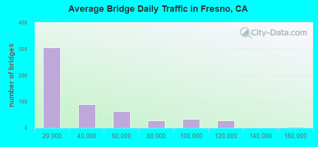
- 16,572,698Total average daily traffic
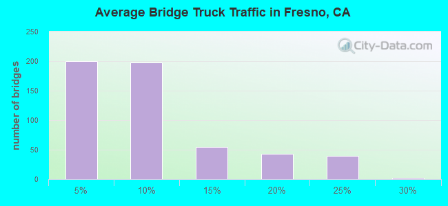
- 1,423,123Total average daily truck traffic
- National Bridge Inventory (NBI) Registered Bridges for Fresno
- No street view available for this location
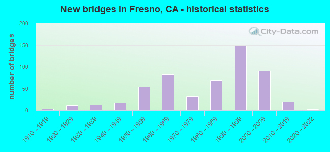
- New bridges - historical statistics
- 11900-1909
- 41910-1919
- 121920-1929
- 131930-1939
- 181940-1949
- 551950-1959
- 831960-1969
- 331970-1979
- 701980-1989
- 1491990-1999
- 912000-2009
- 202010-2019
- 22020-2022
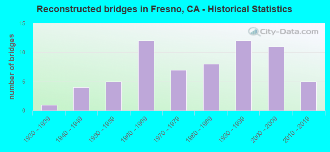
- Reconstructed bridges - Historical Statistics
- 11930-1939
- 41940-1949
- 51950-1959
- 121960-1969
- 71970-1979
- 81980-1989
- 121990-1999
- 112000-2009
- 52010-2019
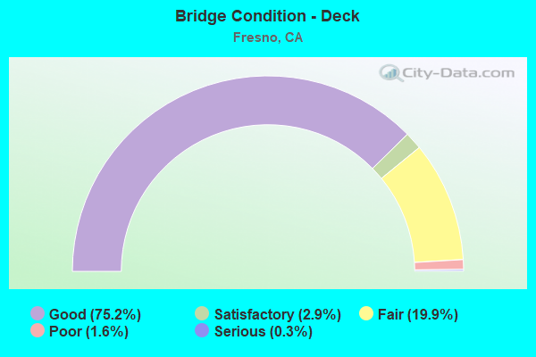
- Bridge Condition - Deck
- 75.2%Good
- 2.9%Satisfactory
- 19.9%Fair
- 1.6%Poor
- 0.3%Serious
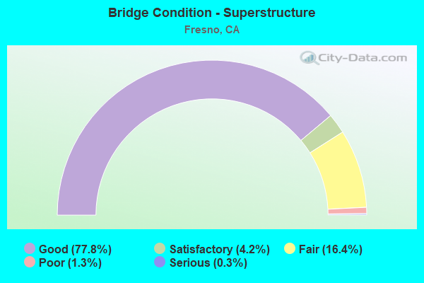
- Bridge Condition - Superstructure
- 77.8%Good
- 4.2%Satisfactory
- 16.4%Fair
- 1.3%Poor
- 0.3%Serious
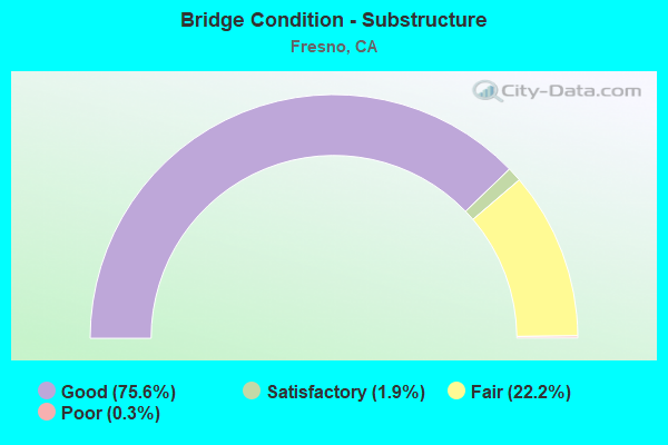
- Bridge Condition - Substructure
- 75.6%Good
- 1.9%Satisfactory
- 22.2%Fair
- 0.3%Poor
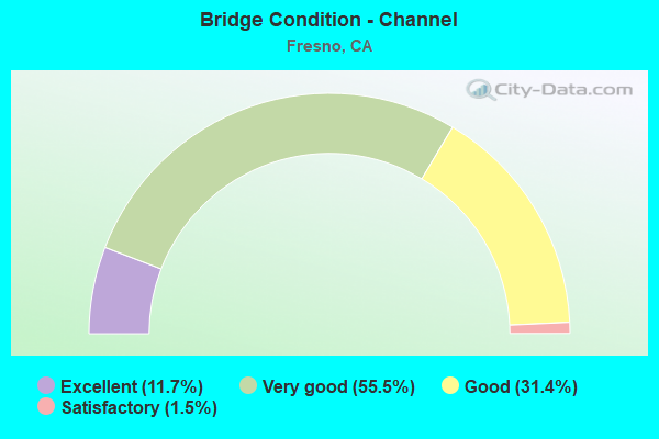
- Bridge Condition - Channel
- 11.7%Excellent
- 55.5%Very good
- 31.4%Good
- 1.5%Satisfactory
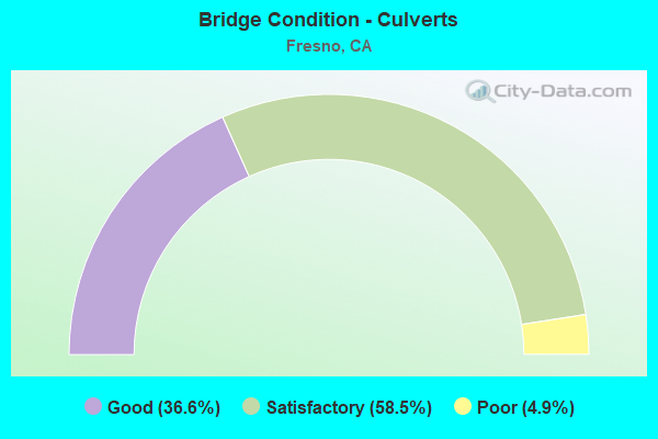
- Bridge Condition - Culverts
- 36.6%Good
- 58.5%Satisfactory
- 4.9%Poor
Find on map >> Show street view
Structure Number: 42 0208L, Location: 06-FRE-099-16.55 (Lat: 36.684958, Lng: -119.749931), Route carried "on" structure: State highway 99, Year Built: 1963, Status: Open, Structure Length: 7.77m (25.49ft), Average Daily Traffic: 48,000 (year 2009), Truck Traffic: 22%, Average Future Daily Traffic: 73,362 (year 2043), Design Load: HS 20+Mod, Features Intersected: BNSF RY & AMTRAK
Minimum Vertical Clearance: 30+ m (98+ ft), Kilometerpoint: 16.550, Lanes on structure: 3, Base Highway Network: Yes (, Subroute: 1), Owner: State Highway Agency, Approaching Roadway Width: 14.0m (45.9ft), Skew: 4 degrees, Material/Design: Concrete continuous, Design/Construction: Box Beam or Girders - Multiple, Number Of Spans In Main Unit: 4, Length of Maximum Span: 26.8m (87.9ft), Curb-To-Curb Width: 14.9m (48.9ft), Out-to-Out Width: 15.8m (51.8ft)
Condition: Deck: Good, Superstructure: Good, Substructure: Good, Operating Rating: 52.8 metric tons, Method Used To Determine Operating Rating: Load and Resistance Factor Rating (LRFR) rating reported by rating factor(RF) method using HL-93 loadings, Inventory Rating: 37.9 metric tons, Method Used To Determine Inventory Rating: Load and Resistance Factor Rating (LRFR) rating reported by rating factor(RF) method using HL-93 loadings, Structural Evaluation: Better than present minimum criteria, Deck Geometry: Meets minimum limits, Underclear: High priority of corrective action, Approach Roadway Alignment: Better than present minimum criteria, Designated Inspection Frequency: Every 24 months, Inspection Date: April 2021, Deck Structure Type: Concrete Cast-file-Place, Wearing Surface/Protective System: Wearing Surface: Integral Concrete
Find on map >> Show street view
Structure Number: 42 0208R, Location: 06-FRE-099-16.55 (Lat: 36.685289, Lng: -119.749936), Route carried "on" structure: State highway 99, Year Built: 1963, Status: Open, Structure Length: 6.67m (21.88ft), Average Daily Traffic: 48,000 (year 2009), Truck Traffic: 22%, Average Future Daily Traffic: 73,362 (year 2043), Design Load: HS 20+Mod, Features Intersected: BNSF RY & AMTRAK
Minimum Vertical Clearance: 30+ m (98+ ft), Kilometerpoint: 16.550, Lanes on structure: 3, Base Highway Network: Yes (, Subroute: 1), Owner: State Highway Agency, Approaching Roadway Width: 14.0m (45.9ft), Skew: 4 degrees, Material/Design: Concrete continuous, Design/Construction: Box Beam or Girders - Multiple, Number Of Spans In Main Unit: 3, Length of Maximum Span: 29.9m (98.1ft), Curb-To-Curb Width: 14.9m (48.9ft), Out-to-Out Width: 15.8m (51.8ft)
Condition: Deck: Good, Superstructure: Good, Substructure: Good, Operating Rating: 50.2 metric tons, Method Used To Determine Operating Rating: Load and Resistance Factor Rating (LRFR) rating reported by rating factor(RF) method using HL-93 loadings, Inventory Rating: 38.9 metric tons, Method Used To Determine Inventory Rating: Load and Resistance Factor Rating (LRFR) rating reported by rating factor(RF) method using HL-93 loadings, Structural Evaluation: Better than present minimum criteria, Deck Geometry: Meets minimum limits, Underclear: High priority of corrective action, Approach Roadway Alignment: Better than present minimum criteria, Designated Inspection Frequency: Every 24 months, Inspection Date: April 2021, Deck Structure Type: Concrete Cast-file-Place, Wearing Surface/Protective System: Wearing Surface: Integral Concrete
Find on map >> Show street view
Structure Number: 42 0209, Location: 06-FRE-099-16.93 (Lat: 36.688600, Lng: -119.754664), Route carried "on" structure: Business City street F395, Year Built: 1963, Status: Open, Structure Length: 8.72m (28.61ft), Average Daily Traffic: 938 (year 2015), Truck Traffic: 20%, Average Future Daily Traffic: 3,038 (year 2039), Design Load: HS 20+Mod, Features Intersected: STATE ROUTE 99, Facility Carried by Structure: CEDAR AVENUE
Minimum Vertical Clearance: 30+ m (98+ ft), Kilometerpoint: 0.000, Lanes on structure: 2, Lanes under structure: 6, Owner: State Highway Agency, Approaching Roadway Width: 12.2m (40.0ft), Skew: 4 degrees, Material/Design: Concrete continuous, Design/Construction: Box Beam or Girders - Multiple, Number Of Spans In Main Unit: 4, Length of Maximum Span: 30.8m (101.0ft), Curb or Sidewalk Widths: Left: 1.5m (4.9ft), Right: 0.0m, Curb-To-Curb Width: 9.8m (32.2ft), Out-to-Out Width: 12.0m (39.4ft)
Condition: Deck: Good, Superstructure: Good, Substructure: Good, Operating Rating: 42.4 metric tons, Method Used To Determine Operating Rating: Load and Resistance Factor Rating (LRFR) rating reported by rating factor(RF) method using HL-93 loadings, Inventory Rating: 32.7 metric tons, Method Used To Determine Inventory Rating: Load and Resistance Factor Rating (LRFR) rating reported by rating factor(RF) method using HL-93 loadings, Structural Evaluation: Better than present minimum criteria, Deck Geometry: Equal to present minimum criteria, Underclear: Meets minimum limits, Approach Roadway Alignment: Equal to present minimum criteria, Designated Inspection Frequency: Every 24 months, Inspection Date: April 2021, Deck Structure Type: Concrete Cast-file-Place, Wearing Surface/Protective System: Wearing Surface: Bituminous
Find on map >> Show street view
Structure Number: 42 021, Location: 06-FRE-099-17.26 (Lat: 36.692356, Lng: -119.759264), Route carried "on" structure: County highway F339, Year Built: 1963, Status: Open, Structure Length: 8.47m (27.79ft), Average Daily Traffic: 8,042 (year 2015), Truck Traffic: 20%, Average Future Daily Traffic: 11,900 (year 2039), Design Load: HS 20+Mod, Features Intersected: STATE ROUTE 99, Facility Carried by Structure: NORTH AVE
Minimum Vertical Clearance: 30+ m (98+ ft), Kilometerpoint: 0.000, Lanes on structure: 2, Lanes under structure: 6, Base Highway Network: Yes, Owner: State Highway Agency, Approaching Roadway Width: 12.2m (40.0ft), Skew: 4 degrees, Material/Design: Concrete continuous, Design/Construction: Box Beam or Girders - Multiple, Number Of Spans In Main Unit: 4, Length of Maximum Span: 30.2m (99.1ft), Curb or Sidewalk Widths: Left: 0.0m, Right: 1.5m (4.9ft), Curb-To-Curb Width: 9.8m (32.2ft), Out-to-Out Width: 12.0m (39.4ft)
Condition: Deck: Good, Superstructure: Good, Substructure: Good, Operating Rating: 53.5 metric tons, Method Used To Determine Operating Rating: Load and Resistance Factor Rating (LRFR) rating reported by rating factor(RF) method using HL-93 loadings, Inventory Rating: 38.6 metric tons, Method Used To Determine Inventory Rating: Load and Resistance Factor Rating (LRFR) rating reported by rating factor(RF) method using HL-93 loadings, Structural Evaluation: Better than present minimum criteria, Deck Geometry: Meets minimum limits, Underclear: Meets minimum limits, Approach Roadway Alignment: Equal to present desirable criteria, Designated Inspection Frequency: Every 24 months, Inspection Date: April 2021, Deck Structure Type: Concrete Cast-file-Place
Find on map >> Show street view
Structure Number: 42 0211, Location: 06-FRE-099-17.65 (Lat: 36.695994, Lng: -119.763667), Route carried "on" structure: County highway F394, Year Built: 1963, Status: Open, Structure Length: 9.57m (31.40ft), Average Daily Traffic: 2,602 (year 2010), Truck Traffic: 15%, Average Future Daily Traffic: 4,419 (year 2043), Design Load: HS 20+Mod, Features Intersected: STATE ROUTE 99, Facility Carried by Structure: ORANGE AVE
Minimum Vertical Clearance: 30+ m (98+ ft), Kilometerpoint: 0.000, Lanes on structure: 2, Lanes under structure: 6, Owner: State Highway Agency, Approaching Roadway Width: 11.0m (36.1ft), Skew: 4 degrees, Material/Design: Concrete continuous, Design/Construction: Box Beam or Girders - Multiple, Number Of Spans In Main Unit: 4, Length of Maximum Span: 32.3m (106.0ft), Curb or Sidewalk Widths: Left: 0.0m, Right: 1.5m (4.9ft), Curb-To-Curb Width: 9.8m (32.2ft), Out-to-Out Width: 12.0m (39.4ft)
Condition: Deck: Satisfactory, Superstructure: Good, Substructure: Satisfactory, Operating Rating: 50.2 metric tons, Method Used To Determine Operating Rating: Load and Resistance Factor Rating (LRFR) rating reported by rating factor(RF) method using HL-93 loadings, Inventory Rating: 36.6 metric tons, Method Used To Determine Inventory Rating: Load and Resistance Factor Rating (LRFR) rating reported by rating factor(RF) method using HL-93 loadings, Structural Evaluation: Equal to present minimum criteria, Deck Geometry: Meets minimum limits, Underclear: Meets minimum limits, Approach Roadway Alignment: Equal to present desirable criteria, Designated Inspection Frequency: Every 24 months, Inspection Date: April 2021, Deck Structure Type: Concrete Cast-file-Place
Find on map >> Show street view
Structure Number: 42 0213, Location: 06-FRE-099-18.54 (Lat: 36.706647, Lng: -119.773467), Route carried "on" structure: State highway 99, Year Built: 1963, Year Reconstructed: 2002, Status: Open, Structure Length: 6.04m (19.82ft), Average Daily Traffic: 96,000 (year 2010), Truck Traffic: 22%, Average Future Daily Traffic: 146,726 (year 2043), Design Load: HS 20+Mod, Features Intersected: JENSEN AVE
Minimum Vertical Clearance: 30+ m (98+ ft), Kilometerpoint: 18.540, Lanes on structure: 9, Lanes under structure: 4, Base Highway Network: Yes (, Subroute: 1), Owner: State Highway Agency, Approaching Roadway Width: 45.0m (147.6ft), Skew: 4 degrees, Material/Design: Concrete continuous, Design/Construction: Box Beam or Girders - Multiple, Number Of Spans In Main Unit: 4, Length of Maximum Span: 18.6m (61.0ft), Curb or Sidewalk Widths: Left: 0.0m, Right: 0.6m (2.0ft), Curb-To-Curb Width: 45.1m (148.0ft), Out-to-Out Width: 46.8m (153.5ft)
Condition: Deck: Good, Superstructure: Good, Substructure: Good, Operating Rating: 54.1 metric tons, Method Used To Determine Operating Rating: Field evaluation and documented engineering judgment, Inventory Rating: 32.4 metric tons, Method Used To Determine Inventory Rating: Field evaluation and documented engineering judgment, Structural Evaluation: Better than present minimum criteria, Deck Geometry: Superior to present desirable criteria, Underclear: High priority of corrective action, Approach Roadway Alignment: Equal to present desirable criteria, Designated Inspection Frequency: Every 24 months, Inspection Date: April 2021, Deck Structure Type: Concrete Cast-file-Place
Find on map >> Show street view
Structure Number: 42 0214, Location: 06-FRE-099-19.20-FRE (Lat: 36.714086, Lng: -119.781606), Route carried "on" structure: City street F341, Year Built: 1963, Status: Open, Structure Length: 8.47m (27.79ft), Average Daily Traffic: 12,345 (year 2010), Truck Traffic: 20%, Average Future Daily Traffic: 20,994 (year 2043), Design Load: HS 20+Mod, Features Intersected: STATE ROUTE 99, Facility Carried by Structure: CHURCH AVE
Minimum Vertical Clearance: 30+ m (98+ ft), Kilometerpoint: 0.000, Lanes on structure: 2, Lanes under structure: 9, Owner: State Highway Agency, Approaching Roadway Width: 17.4m (57.1ft), Skew: 3 degrees, Material/Design: Concrete continuous, Design/Construction: Box Beam or Girders - Multiple, Number Of Spans In Main Unit: 4, Length of Maximum Span: 33.5m (109.9ft), Curb or Sidewalk Widths: Left: 1.5m (4.9ft), Right: 1.5m (4.9ft), Curb-To-Curb Width: 19.5m (64.0ft), Out-to-Out Width: 23.2m (76.1ft)
Condition: Deck: Satisfactory, Superstructure: Good, Substructure: Good, Operating Rating: 46.7 metric tons, Method Used To Determine Operating Rating: Load and Resistance Factor Rating (LRFR) rating reported by rating factor(RF) method using HL-93 loadings, Inventory Rating: 33.4 metric tons, Method Used To Determine Inventory Rating: Load and Resistance Factor Rating (LRFR) rating reported by rating factor(RF) method using HL-93 loadings, Structural Evaluation: Better than present minimum criteria, Deck Geometry: Superior to present desirable criteria, Underclear: Meets minimum limits, Approach Roadway Alignment: Equal to present desirable criteria, Designated Inspection Frequency: Every 24 months, Inspection Date: April 2021, Deck Structure Type: Concrete Cast-file-Place
Find on map >> Show street view
Structure Number: 42 0216F, Location: 06-FRE-041-R21.81-FRE (Lat: 36.717508, Lng: -119.784861), Route carried "on" structure: Ramp State highway 41, Year Built: 1963, Status: Open, Structure Length: 20.27m (66.50ft), Average Daily Traffic: 21,300 (year 1998), Truck Traffic: 5%, Average Future Daily Traffic: 32,604 (year 2040), Design Load: HS 20+Mod, Features Intersected: SR 99 & N41-N99 CONNECTR
Minimum Vertical Clearance: 30+ m (98+ ft), Kilometerpoint: 21.810, Lanes on structure: 2, Lanes under structure: 7, Base Highway Network: Yes (, Subroute: 1), Owner: State Highway Agency, Approaching Roadway Width: 7.3m (24.0ft), Material/Design: Concrete continuous, Design/Construction: Box Beam or Girders - Multiple, Number Of Spans In Main Unit: 4, Length of Maximum Span: 56.7m (186.0ft), Curb-To-Curb Width: 11.3m (37.1ft), Out-to-Out Width: 12.1m (39.7ft)
Condition: Deck: Good, Superstructure: Fair, Substructure: Good, Operating Rating: 36.6 metric tons, Method Used To Determine Operating Rating: Load and Resistance Factor Rating (LRFR) rating reported by rating factor(RF) method using HL-93 loadings, Inventory Rating: 28.2 metric tons, Method Used To Determine Inventory Rating: Load and Resistance Factor Rating (LRFR) rating reported by rating factor(RF) method using HL-93 loadings, Structural Evaluation: Somewhat better than minimum adequacy, Deck Geometry: Superior to present desirable criteria, Underclear: Meets minimum limits, Approach Roadway Alignment: Equal to present desirable criteria, Designated Inspection Frequency: Every 24 months, Inspection Date: October 2020, Deck Structure Type: Concrete Cast-file-Place
Find on map >> Show street view
Structure Number: 42 0217, Location: 06-FRE-099-19.86-FRE (Lat: 36.721378, Lng: -119.789028), Route carried "on" structure: City street F342, Year Built: 1963, Status: Open, Structure Length: 8.37m (27.46ft), Average Daily Traffic: 3,200 (year 2018), Truck Traffic: 10%, Average Future Daily Traffic: 5,500 (year 2040), Design Load: HS 20+Mod, Features Intersected: STATE ROUTE 99, Facility Carried by Structure: CALIFORNIA AVE
Minimum Vertical Clearance: 30+ m (98+ ft), Kilometerpoint: 0.000, Lanes on structure: 2, Lanes under structure: 8, Owner: State Highway Agency, Approaching Roadway Width: 14.6m (47.9ft), Skew: 4 degrees, Material/Design: Concrete continuous, Design/Construction: Box Beam or Girders - Multiple, Number Of Spans In Main Unit: 4, Length of Maximum Span: 32.0m (105.0ft), Curb or Sidewalk Widths: Left: 1.5m (4.9ft), Right: 1.5m (4.9ft), Curb-To-Curb Width: 18.3m (60.0ft), Out-to-Out Width: 21.9m (71.9ft)
Condition: Deck: Good, Superstructure: Good, Substructure: Good, Operating Rating: 47.3 metric tons, Method Used To Determine Operating Rating: Load and Resistance Factor Rating (LRFR) rating reported by rating factor(RF) method using HL-93 loadings, Inventory Rating: 36.3 metric tons, Method Used To Determine Inventory Rating: Load and Resistance Factor Rating (LRFR) rating reported by rating factor(RF) method using HL-93 loadings, Structural Evaluation: Better than present minimum criteria, Deck Geometry: Superior to present desirable criteria, Underclear: Meets minimum limits, Approach Roadway Alignment: Equal to present desirable criteria, Designated Inspection Frequency: Every 24 months, Inspection Date: November 2021, Deck Structure Type: Concrete Cast-file-Place
Find on map >> Show street view
Structure Number: 42 0218K, Location: 06-FRE-099-20.06-FRE (Lat: 36.723789, Lng: -119.790619), Route carried "on" structure: Ramp State highway 99, Year Built: 1963, Status: Open, Structure Length: 10.27m (33.69ft), Average Daily Traffic: 23,000 (year 2018), Truck Traffic: 2%, Average Future Daily Traffic: 27,000 (year 2040), Design Load: HS 20+Mod, Features Intersected: STATE ROUTE 99 & RAMPS
Minimum Vertical Clearance: 30+ m (98+ ft), Kilometerpoint: 20.060, Lanes on structure: 2, Lanes under structure: 10, Owner: State Highway Agency, Approaching Roadway Width: 8.5m (27.9ft), Skew: 9 degrees, Material/Design: Concrete continuous, Design/Construction: Box Beam or Girders - Multiple, Number Of Spans In Main Unit: 4, Length of Maximum Span: 32.6m (107.0ft), Curb or Sidewalk Widths: Left: 0.6m (2.0ft), Right: 0.0m, Curb-To-Curb Width: 11.1m (36.4ft), Out-to-Out Width: 12.4m (40.7ft)
Condition: Deck: Fair, Superstructure: Good, Substructure: Good, Operating Rating: 58.0 metric tons, Method Used To Determine Operating Rating: Load Factor (LF), Inventory Rating: 34.7 metric tons, Method Used To Determine Inventory Rating: Load Factor (LF), Structural Evaluation: Better than present minimum criteria, Deck Geometry: Equal to present desirable criteria, Underclear: Meets minimum limits, Approach Roadway Alignment: Equal to present minimum criteria, Designated Inspection Frequency: Every 24 months, Inspection Date: November 2021, Deck Structure Type: Concrete Cast-file-Place, Wearing Surface/Protective System: Wearing Surface: Bituminous, Membrane: Preformed Fabric
Find on map >> Show street view
Structure Number: 42 022, Location: 06-FRE-099-R4.91-SEL (Lat: 36.559550, Lng: -119.610639), Route carried "on" structure: State highway 99, Year Built: 1964, Year Reconstructed: 2008, Status: Open, Structure Length: 5.55m (18.21ft), Average Daily Traffic: 57,000 (year 2009), Truck Traffic: 24%, Average Future Daily Traffic: 94,000 (year 2039), Design Load: HS 20+Mod, Features Intersected: MCCALL AVE
Minimum Vertical Clearance: 30+ m (98+ ft), Kilometerpoint: 4.910, Lanes on structure: 6, Lanes under structure: 2, Base Highway Network: Yes (, Subroute: 1), Owner: State Highway Agency, Approaching Roadway Width: 34.0m (111.5ft), Skew: 34 degrees, Material/Design: Concrete continuous, Design/Construction: Box Beam or Girders - Multiple, Number Of Spans In Main Unit: 3, Length of Maximum Span: 28.7m (94.2ft), Curb-To-Curb Width: 34.0m (111.5ft), Out-to-Out Width: 35.6m (116.8ft)
Condition: Deck: Good, Superstructure: Good, Substructure: Good, Operating Rating: 31.1 metric tons, Method Used To Determine Operating Rating: Load and Resistance Factor Rating (LRFR) rating reported by rating factor(RF) method using HL-93 loadings, Inventory Rating: 18.5 metric tons, Method Used To Determine Inventory Rating: Load and Resistance Factor Rating (LRFR) rating reported by rating factor(RF) method using HL-93 loadings, Structural Evaluation: Meets minimum limits, Deck Geometry: Superior to present desirable criteria, Underclear: Equal to present minimum criteria, Approach Roadway Alignment: Equal to present desirable criteria, Designated Inspection Frequency: Every 24 months, Inspection Date: April 2021, Deck Structure Type: Concrete Cast-file-Place, Wearing Surface/Protective System: Wearing Surface: Integral Concrete
Find on map >> Show street view
Structure Number: 42 0226L, Location: 06-FRE-041-R22.11-FRE (Lat: 36.721258, Lng: -119.785375), Route carried "on" structure: State highway 41, Year Built: 1966, Status: Open, Structure Length: 64.56m (211.81ft), Average Daily Traffic: 38,000 (year 2009), Truck Traffic: 4%, Average Future Daily Traffic: 64,065 (year 2042), Design Load: HS 20+Mod, Features Intersected: CALIF,GOLDEN ST,G,BROAD
Minimum Vertical Clearance: 30+ m (98+ ft), Kilometerpoint: 22.110, Lanes on structure: 3, Lanes under structure: 18, Base Highway Network: Yes (, Subroute: 1), Owner: State Highway Agency, Approaching Roadway Width: 22.9m (75.1ft), Material/Design: Steel continuous, Design/Construction: Stringer/Multi-beam, Number Of Spans In Main Unit: 2, Number Of Approach Spans: 16, Length of Maximum Span: 48.8m (160.1ft), Curb-To-Curb Width: 14.9m (48.9ft), Out-to-Out Width: 15.5m (50.9ft)
Condition: Deck: Good, Superstructure: Good, Substructure: Good, Operating Rating: 64.8 metric tons, Method Used To Determine Operating Rating: Load Factor (LF), Inventory Rating: 38.9 metric tons, Method Used To Determine Inventory Rating: Load Factor (LF), Structural Evaluation: Better than present minimum criteria, Deck Geometry: Meets minimum limits, Underclear: Meets minimum limits, Approach Roadway Alignment: Equal to present desirable criteria, Designated Inspection Frequency: Every 24 months, Critical Feature Inspection Frequency: Every 24 months, Other Special Inspection Frequency: Every 48 months, Inspection Date: October 2020, Critical Feature Inspection Date: March 2021, Other Special Inspection Date: March 2021, Deck Structure Type: Concrete Cast-file-Place, Wearing Surface/Protective System: Wearing Surface: Integral Concrete
Find on map >> Show street view
Structure Number: 42 0226R, Location: 06-FRE-041-R22.11-FRE (Lat: 36.721258, Lng: -119.784997), Route carried "on" structure: State highway 41, Year Built: 1966, Status: Open, Structure Length: 64.56m (211.81ft), Average Daily Traffic: 38,000 (year 2009), Truck Traffic: 4%, Average Future Daily Traffic: 64,065 (year 2042), Design Load: HS 20+Mod, Features Intersected: CALIF,GOLDEN ST,G,BROAD
Minimum Vertical Clearance: 30+ m (98+ ft), Kilometerpoint: 22.110, Lanes on structure: 3, Lanes under structure: 20, Base Highway Network: Yes (, Subroute: 1), Owner: State Highway Agency, Approaching Roadway Width: 22.9m (75.1ft), Skew: 9 degrees, Material/Design: Steel continuous, Design/Construction: Stringer/Multi-beam, Number Of Spans In Main Unit: 2, Number Of Approach Spans: 16, Length of Maximum Span: 49.4m (162.1ft), Curb-To-Curb Width: 14.9m (48.9ft), Out-to-Out Width: 15.5m (50.9ft)
Condition: Deck: Good, Superstructure: Good, Substructure: Good, Operating Rating: 23.0 metric tons, Method Used To Determine Operating Rating: Load and Resistance Factor Rating (LRFR) rating reported by rating factor(RF) method using HL-93 loadings, Inventory Rating: 16.8 metric tons, Method Used To Determine Inventory Rating: Load and Resistance Factor Rating (LRFR) rating reported by rating factor(RF) method using HL-93 loadings, Structural Evaluation: Meets minimum limits, Deck Geometry: Meets minimum limits, Underclear: Meets minimum limits, Approach Roadway Alignment: Equal to present desirable criteria, Designated Inspection Frequency: Every 24 months, Critical Feature Inspection Frequency: Every 24 months, Other Special Inspection Frequency: Every 48 months, Inspection Date: October 2020, Critical Feature Inspection Date: March 2021, Other Special Inspection Date: March 2021, Deck Structure Type: Concrete Cast-file-Place, Wearing Surface/Protective System: Wearing Surface: Integral Concrete
Find on map >> Show street view
Structure Number: 42 0227L, Location: 06-FRE-041-R22.65-FRE (Lat: 36.728678, Lng: -119.782839), Route carried "on" structure: State highway 41, Year Built: 1969, Status: Open, Structure Length: 3.99m (13.09ft), Average Daily Traffic: 38,000 (year 2009), Truck Traffic: 4%, Average Future Daily Traffic: 64,065 (year 2042), Design Load: HS 20+Mod, Features Intersected: VAN NESS AVE
Minimum Vertical Clearance: 30+ m (98+ ft), Kilometerpoint: 22.650, Lanes on structure: 4, Lanes under structure: 3, Base Highway Network: Yes (, Subroute: 1), Owner: State Highway Agency, Approaching Roadway Width: 22.3m (73.2ft), Skew: 21 degrees, Material/Design: Prestressed concrete, Design/Construction: Box Beam or Girders - Multiple, Number Of Spans In Main Unit: 1, Length of Maximum Span: 39.9m (130.9ft), Curb-To-Curb Width: 22.3m (73.2ft), Out-to-Out Width: 22.9m (75.1ft)
Condition: Deck: Good, Superstructure: Good, Substructure: Good, Operating Rating: 90.1 metric tons, Method Used To Determine Operating Rating: Load Factor (LF), Inventory Rating: 32.4 metric tons, Method Used To Determine Inventory Rating: Load Factor (LF), Structural Evaluation: Better than present minimum criteria, Deck Geometry: Superior to present desirable criteria, Underclear: Meets minimum limits, Approach Roadway Alignment: Equal to present desirable criteria, Designated Inspection Frequency: Every 24 months, Inspection Date: October 2020, Deck Structure Type: Concrete Cast-file-Place
Find on map >> Show street view
Structure Number: 42 0227R, Location: 06-FRE-041-R22.65-FRE (Lat: 36.728486, Lng: -119.782639), Route carried "on" structure: State highway 41, Year Built: 1969, Status: Open, Structure Length: 3.99m (13.09ft), Average Daily Traffic: 38,000 (year 2009), Truck Traffic: 4%, Average Future Daily Traffic: 64,065 (year 2042), Design Load: HS 20+Mod, Features Intersected: VAN NESS AVE
Minimum Vertical Clearance: 30+ m (98+ ft), Kilometerpoint: 22.650, Lanes on structure: 3, Lanes under structure: 4, Base Highway Network: Yes (, Subroute: 1), Owner: State Highway Agency, Approaching Roadway Width: 15.5m (50.9ft), Skew: 1 degrees, Material/Design: Prestressed concrete, Design/Construction: Box Beam or Girders - Multiple, Number Of Spans In Main Unit: 1, Length of Maximum Span: 39.6m (129.9ft), Curb-To-Curb Width: 15.5m (50.9ft), Out-to-Out Width: 16.2m (53.1ft)
Condition: Deck: Good, Superstructure: Good, Substructure: Good, Operating Rating: 82.3 metric tons, Method Used To Determine Operating Rating: Load Factor (LF), Inventory Rating: 32.4 metric tons, Method Used To Determine Inventory Rating: Load Factor (LF), Structural Evaluation: Better than present minimum criteria, Deck Geometry: Somewhat better than minimum adequacy, Underclear: Meets minimum limits, Approach Roadway Alignment: Equal to present desirable criteria, Designated Inspection Frequency: Every 24 months, Inspection Date: October 2020, Deck Structure Type: Concrete Cast-file-Place
Find on map >> Show street view
Structure Number: 42 0227S, Location: 06-FRE-041-R22.65-FRE (Lat: 36.727892, Lng: -119.782650), Route carried "on" structure: Bypass State highway 41, Year Built: 1974, Status: Open, Structure Length: 12.19m (39.99ft), Average Daily Traffic: 6,600 (year 1998), Truck Traffic: 4%, Average Future Daily Traffic: 10,868 (year 2040), Design Load: HS 20+Mod, Features Intersected: N41-VAN NESS OFF,VAN NES
Minimum Vertical Clearance: 30+ m (98+ ft), Kilometerpoint: 22.650, Lanes on structure: 1, Lanes under structure: 6, Base Highway Network: Yes (, Subroute: 1), Owner: State Highway Agency, Approaching Roadway Width: 7.3m (24.0ft), Material/Design: Prestressed concrete continuous, Design/Construction: Box Beam or Girders - Multiple, Number Of Spans In Main Unit: 3, Length of Maximum Span: 47.5m (155.8ft), Curb-To-Curb Width: 7.3m (24.0ft), Out-to-Out Width: 7.9m (25.9ft)
Condition: Deck: Fair, Superstructure: Good, Substructure: Good, Operating Rating: 61.2 metric tons, Method Used To Determine Operating Rating: Load and Resistance Factor Rating (LRFR) rating reported by rating factor(RF) method using HL-93 loadings, Inventory Rating: 39.2 metric tons, Method Used To Determine Inventory Rating: Load and Resistance Factor Rating (LRFR) rating reported by rating factor(RF) method using HL-93 loadings, Structural Evaluation: Better than present minimum criteria, Deck Geometry: High priority of replacement, Underclear: Better than present minimum criteria, Approach Roadway Alignment: Equal to present desirable criteria, Designated Inspection Frequency: Every 24 months, Inspection Date: October 2020, Deck Structure Type: Concrete Cast-file-Place
Find on map >> Show street view
Structure Number: 42 0228K, Location: 06-FRE-041-R22.77-FRE (Lat: 36.730269, Lng: -119.781761), Route carried "on" structure: Ramp State highway 41, Year Built: 1974, Status: Open, Structure Length: 8.99m (29.49ft), Average Daily Traffic: 4,950 (year 2011), Truck Traffic: 4%, Average Future Daily Traffic: 5,307 (year 2043), Design Load: HS 20+Mod, Features Intersected: M ST-S41 ON-RAMP, M ST
Minimum Vertical Clearance: 30+ m (98+ ft), Kilometerpoint: 22.770, Lanes on structure: 1, Lanes under structure: 4, Owner: State Highway Agency, Approaching Roadway Width: 7.6m (24.9ft), Material/Design: Prestressed concrete continuous, Design/Construction: Box Beam or Girders - Multiple, Number Of Spans In Main Unit: 3, Length of Maximum Span: 34.0m (111.5ft), Curb-To-Curb Width: 6.9m (22.6ft), Out-to-Out Width: 7.9m (25.9ft)
Condition: Deck: Good, Superstructure: Good, Substructure: Fair, Operating Rating: 49.6 metric tons, Method Used To Determine Operating Rating: Load and Resistance Factor Rating (LRFR) rating reported by rating factor(RF) method using HL-93 loadings, Inventory Rating: 38.2 metric tons, Method Used To Determine Inventory Rating: Load and Resistance Factor Rating (LRFR) rating reported by rating factor(RF) method using HL-93 loadings, Structural Evaluation: Somewhat better than minimum adequacy, Deck Geometry: Equal to present minimum criteria, Underclear: Meets minimum limits, Approach Roadway Alignment: Equal to present desirable criteria, Designated Inspection Frequency: Every 24 months, Inspection Date: May 2021, Deck Structure Type: Concrete Cast-file-Place
Find on map >> Show street view
Structure Number: 42 0228L, Location: 06-FRE-041-R22.80-FRE (Lat: 36.730328, Lng: -119.781017), Route carried "on" structure: State highway 41, Year Built: 1974, Status: Open, Structure Length: 3.99m (13.09ft), Average Daily Traffic: 38,000 (year 2009), Truck Traffic: 4%, Average Future Daily Traffic: 65,576 (year 2043), Design Load: HS 20+Mod, Features Intersected: M STREET
Minimum Vertical Clearance: 30+ m (98+ ft), Kilometerpoint: 22.800, Lanes on structure: 3, Lanes under structure: 3, Base Highway Network: Yes (, Subroute: 1), Owner: State Highway Agency, Approaching Roadway Width: 15.5m (50.9ft), Material/Design: Prestressed concrete, Design/Construction: Box Beam or Girders - Multiple, Number Of Spans In Main Unit: 1, Length of Maximum Span: 39.9m (130.9ft), Curb-To-Curb Width: 15.1m (49.5ft), Out-to-Out Width: 16.2m (53.1ft)
Condition: Deck: Good, Superstructure: Good, Substructure: Good, Operating Rating: 47.6 metric tons, Method Used To Determine Operating Rating: Load and Resistance Factor Rating (LRFR) rating reported by rating factor(RF) method using HL-93 loadings, Inventory Rating: 31.1 metric tons, Method Used To Determine Inventory Rating: Load and Resistance Factor Rating (LRFR) rating reported by rating factor(RF) method using HL-93 loadings, Structural Evaluation: Better than present minimum criteria, Deck Geometry: Meets minimum limits, Underclear: Equal to present minimum criteria, Approach Roadway Alignment: Equal to present desirable criteria, Designated Inspection Frequency: Every 24 months, Inspection Date: May 2021, Deck Structure Type: Concrete Cast-file-Place, Wearing Surface/Protective System: Wearing Surface: Integral Concrete
Find on map >> Show street view
Structure Number: 42 0228R, Location: 06-FRE-041-R22.80-FRE (Lat: 36.730136, Lng: -119.780789), Route carried "on" structure: State highway 41, Year Built: 1974, Status: Open, Structure Length: 3.93m (12.89ft), Average Daily Traffic: 38,000 (year 2009), Truck Traffic: 4%, Average Future Daily Traffic: 65,576 (year 2043), Design Load: HS 20+Mod, Features Intersected: M STREET
Minimum Vertical Clearance: 30+ m (98+ ft), Kilometerpoint: 22.800, Lanes on structure: 4, Lanes under structure: 3, Base Highway Network: Yes (, Subroute: 1), Owner: State Highway Agency, Approaching Roadway Width: 18.6m (61.0ft), Material/Design: Prestressed concrete, Design/Construction: Box Beam or Girders - Multiple, Number Of Spans In Main Unit: 1, Length of Maximum Span: 39.3m (128.9ft), Curb-To-Curb Width: 16.7m (54.8ft), Out-to-Out Width: 17.7m (58.1ft)
Condition: Deck: Good, Superstructure: Good, Substructure: Good, Operating Rating: 49.2 metric tons, Method Used To Determine Operating Rating: Load and Resistance Factor Rating (LRFR) rating reported by rating factor(RF) method using HL-93 loadings, Inventory Rating: 33.4 metric tons, Method Used To Determine Inventory Rating: Load and Resistance Factor Rating (LRFR) rating reported by rating factor(RF) method using HL-93 loadings, Structural Evaluation: Better than present minimum criteria, Deck Geometry: High priority of replacement, Underclear: Equal to present minimum criteria, Approach Roadway Alignment: Equal to present desirable criteria, Designated Inspection Frequency: Every 24 months, Inspection Date: May 2021, Deck Structure Type: Concrete Cast-file-Place
Find on map >> Show street view
Structure Number: 42 0229K, Location: 06-FRE-041-R22.58-FRE (Lat: 36.728014, Lng: -119.783669), Route carried "on" structure: Ramp State highway 41, Year Built: 1966, Status: Open, Structure Length: 3.26m (10.70ft), Average Daily Traffic: 780 (year 1998), Truck Traffic: 2%, Average Future Daily Traffic: 1,073 (year 2036), Design Load: HS 20+Mod, Features Intersected: SAN BENITO STREET
Minimum Vertical Clearance: 30+ m (98+ ft), Kilometerpoint: 22.580, Lanes on structure: 1, Lanes under structure: 2, Base Highway Network: Yes (, Subroute: 1), Owner: State Highway Agency, Approaching Roadway Width: 5.2m (17.1ft), Skew: 5 degrees, Material/Design: Concrete continuous, Design/Construction: Box Beam or Girders - Multiple, Number Of Spans In Main Unit: 2, Length of Maximum Span: 22.6m (74.1ft), Curb or Sidewalk Widths: Left: 0.0m, Right: 0.6m (2.0ft), Curb-To-Curb Width: 7.0m (23.0ft), Out-to-Out Width: 8.2m (26.9ft)
Condition: Deck: Good, Superstructure: Good, Substructure: Good, Operating Rating: 80.0 metric tons, Method Used To Determine Operating Rating: Load Factor (LF), Inventory Rating: 48.0 metric tons, Method Used To Determine Inventory Rating: Load Factor (LF), Structural Evaluation: Better than present minimum criteria, Deck Geometry: Equal to present minimum criteria, Underclear: Meets minimum limits, Approach Roadway Alignment: Equal to present desirable criteria, Designated Inspection Frequency: Every 48 months, Inspection Date: October 2018, Deck Structure Type: Concrete Cast-file-Place
Find on map >> Show street view
Structure Number: 42 0260L, Location: 06-FRE-005-13.08 (Lat: 36.231181, Lng: -120.229542), Route carried "on" structure: Interstate 5, Year Built: 1967, Status: Open, Structure Length: 2.56m (8.40ft), Average Daily Traffic: 15,000 (year 2009), Truck Traffic: 31%, Average Future Daily Traffic: 18,776 (year 2043), Design Load: H 20, Features Intersected: S NAPA AVE
Minimum Vertical Clearance: 30+ m (98+ ft), Kilometerpoint: 13.080, Lanes on structure: 2, Base Highway Network: Yes (, Subroute: 1), Owner: State Highway Agency, Approaching Roadway Width: 11.9m (39.0ft), Material/Design: Concrete continuous, Design/Construction: Slab, Number Of Spans In Main Unit: 3, Length of Maximum Span: 9.8m (32.2ft), Curb-To-Curb Width: 11.9m (39.0ft), Out-to-Out Width: 12.6m (41.3ft)
Condition: Deck: Good, Superstructure: Good, Substructure: Good, Operating Rating: 65.8 metric tons, Method Used To Determine Operating Rating: Load Factor (LF), Inventory Rating: 39.5 metric tons, Method Used To Determine Inventory Rating: Load Factor (LF), Structural Evaluation: Better than present minimum criteria, Deck Geometry: Equal to present minimum criteria, Approach Roadway Alignment: Equal to present desirable criteria, Length Of Structure Improvement: 3.45m (11.32ft), Designated Inspection Frequency: Every 24 months, Inspection Date: January 2021, Deck Structure Type: Concrete Cast-file-Place
Find on map >> Show street view
Structure Number: 42 0264L, Location: 06-FRE-041-R18.61-FRE (Lat: 36.692033, Lng: -119.786028), Route carried "on" structure: State highway 41, Year Built: 1997, Status: Open, Structure Length: 4.82m (15.81ft), Average Daily Traffic: 13,500 (year 2009), Average Future Daily Traffic: 18,274 (year 2040), Design Load: HS 20+Mod, Features Intersected: NORTH AVENUE
Minimum Vertical Clearance: 30+ m (98+ ft), Kilometerpoint: 18.610, Lanes on structure: 2, Lanes under structure: 4, Base Highway Network: Yes (, Subroute: 1), Owner: State Highway Agency, Approaching Roadway Width: 13.0m (42.7ft), Material/Design: Prestressed concrete, Design/Construction: Box Beam or Girders - Multiple, Number Of Spans In Main Unit: 1, Length of Maximum Span: 48.2m (158.1ft), Curb-To-Curb Width: 11.9m (39.0ft), Out-to-Out Width: 13.0m (42.7ft)
Condition: Deck: Good, Superstructure: Fair, Substructure: Good, Operating Rating: 54.1 metric tons, Method Used To Determine Operating Rating: Assigned rating based on Load Factor Design (LFD) reported in metric tons, Inventory Rating: 32.4 metric tons, Method Used To Determine Inventory Rating: Assigned rating based on Load Factor Design (LFD) reported in metric tons, Structural Evaluation: Somewhat better than minimum adequacy, Deck Geometry: Better than present minimum criteria, Underclear: Equal to present minimum criteria, Approach Roadway Alignment: Equal to present desirable criteria, Designated Inspection Frequency: Every 24 months, Inspection Date: October 2020, Deck Structure Type: Concrete Cast-file-Place
Find on map >> Show street view
Structure Number: 42 0264R, Location: 06-FRE-041-R18.61 (Lat: 36.692036, Lng: -119.785694), Route carried "on" structure: State highway 41, Year Built: 1997, Status: Open, Structure Length: 4.82m (15.81ft), Average Daily Traffic: 13,500 (year 2009), Average Future Daily Traffic: 18,274 (year 2040), Design Load: HS 20+Mod, Features Intersected: NORTH AVENUE
Minimum Vertical Clearance: 30+ m (98+ ft), Kilometerpoint: 18.610, Lanes on structure: 2, Lanes under structure: 4, Base Highway Network: Yes (, Subroute: 1), Owner: State Highway Agency, Approaching Roadway Width: 13.0m (42.7ft), Material/Design: Prestressed concrete, Design/Construction: Box Beam or Girders - Multiple, Number Of Spans In Main Unit: 1, Length of Maximum Span: 48.2m (158.1ft), Curb-To-Curb Width: 11.9m (39.0ft), Out-to-Out Width: 13.0m (42.7ft)
Condition: Deck: Good, Superstructure: Fair, Substructure: Good, Operating Rating: 54.1 metric tons, Method Used To Determine Operating Rating: Assigned rating based on Load Factor Design (LFD) reported in metric tons, Inventory Rating: 32.4 metric tons, Method Used To Determine Inventory Rating: Assigned rating based on Load Factor Design (LFD) reported in metric tons, Structural Evaluation: Somewhat better than minimum adequacy, Deck Geometry: Better than present minimum criteria, Underclear: Equal to present minimum criteria, Approach Roadway Alignment: Equal to present desirable criteria, Designated Inspection Frequency: Every 24 months, Inspection Date: October 2020, Deck Structure Type: Concrete Cast-file-Place
Find on map >> Show street view
Structure Number: 42 0265L, Location: 06-FRE-041-R21.60-FRE (Lat: 36.713972, Lng: -119.784542), Route carried "on" structure: State highway 41, Year Built: 1997, Status: Open, Structure Length: 3.98m (13.06ft), Average Daily Traffic: 17,250 (year 2009), Truck Traffic: 5%, Average Future Daily Traffic: 44,379 (year 2040), Design Load: HS 20+Mod, Features Intersected: CHURCH AVENUE
Minimum Vertical Clearance: 30+ m (98+ ft), Kilometerpoint: 21.600, Lanes on structure: 4, Lanes under structure: 2, Base Highway Network: Yes (, Subroute: 1), Owner: State Highway Agency, Approaching Roadway Width: 11.9m (39.0ft), Material/Design: Prestressed concrete, Design/Construction: Box Beam or Girders - Multiple, Number Of Spans In Main Unit: 1, Length of Maximum Span: 39.8m (130.6ft), Curb-To-Curb Width: 19.1m (62.7ft), Out-to-Out Width: 20.1m (65.9ft)
Condition: Deck: Good, Superstructure: Good, Substructure: Good, Operating Rating: 54.1 metric tons, Method Used To Determine Operating Rating: Assigned rating based on Load Factor Design (LFD) reported in metric tons, Inventory Rating: 32.4 metric tons, Method Used To Determine Inventory Rating: Assigned rating based on Load Factor Design (LFD) reported in metric tons, Structural Evaluation: Better than present minimum criteria, Deck Geometry: Somewhat better than minimum adequacy, Underclear: Somewhat better than minimum adequacy, Approach Roadway Alignment: Equal to present desirable criteria, Designated Inspection Frequency: Every 24 months, Inspection Date: October 2020, Deck Structure Type: Concrete Cast-file-Place
Find on map >> Show street view
Structure Number: 42 0265R, Location: 06-FRE-041-R21.60-FRE (Lat: 36.713972, Lng: -119.784161), Route carried "on" structure: State highway 41, Year Built: 1997, Status: Open, Structure Length: 3.98m (13.06ft), Average Daily Traffic: 17,250 (year 2009), Truck Traffic: 5%, Average Future Daily Traffic: 44,379 (year 2040), Design Load: HS 20+Mod, Features Intersected: CHURCH AVENUE
Minimum Vertical Clearance: 30+ m (98+ ft), Kilometerpoint: 21.600, Lanes on structure: 3, Lanes under structure: 2, Base Highway Network: Yes (, Subroute: 1), Owner: State Highway Agency, Approaching Roadway Width: 11.9m (39.0ft), Material/Design: Prestressed concrete, Design/Construction: Box Beam or Girders - Multiple, Number Of Spans In Main Unit: 1, Length of Maximum Span: 39.8m (130.6ft), Curb-To-Curb Width: 15.7m (51.5ft), Out-to-Out Width: 16.7m (54.8ft)
Condition: Deck: Good, Superstructure: Fair, Substructure: Good, Operating Rating: 54.1 metric tons, Method Used To Determine Operating Rating: Assigned rating based on Load Factor Design (LFD) reported in metric tons, Inventory Rating: 32.4 metric tons, Method Used To Determine Inventory Rating: Assigned rating based on Load Factor Design (LFD) reported in metric tons, Structural Evaluation: Somewhat better than minimum adequacy, Deck Geometry: Somewhat better than minimum adequacy, Underclear: Somewhat better than minimum adequacy, Approach Roadway Alignment: Equal to present desirable criteria, Designated Inspection Frequency: Every 24 months, Inspection Date: October 2020, Deck Structure Type: Concrete Cast-file-Place
Find on map >> Show street view
Structure Number: 42 0266L, Location: 06-FRE-041-R21.79-FRE (Lat: 36.716664, Lng: -119.784544), Route carried "on" structure: State highway 41, Year Built: 1997, Status: Open, Structure Length: 27.31m (89.60ft), Average Daily Traffic: 17,250 (year 2009), Truck Traffic: 5%, Average Future Daily Traffic: 44,379 (year 2040), Design Load: HS 20+Mod, Features Intersected: SR 99, N41-N99, S41-S99
Minimum Vertical Clearance: 30+ m (98+ ft), Kilometerpoint: 21.790, Lanes on structure: 2, Lanes under structure: 11, Base Highway Network: Yes (, Subroute: 1), Owner: State Highway Agency, Approaching Roadway Width: 7.3m (24.0ft), Material/Design: Prestressed concrete continuous, Design/Construction: Box Beam or Girders - Multiple, Number Of Spans In Main Unit: 6, Length of Maximum Span: 55.8m (183.1ft), Curb-To-Curb Width: 11.9m (39.0ft), Out-to-Out Width: 13.0m (42.7ft)
Condition: Deck: Satisfactory, Superstructure: Good, Substructure: Good, Operating Rating: 54.1 metric tons, Method Used To Determine Operating Rating: Assigned rating based on Load Factor Design (LFD) reported in metric tons, Inventory Rating: 32.4 metric tons, Method Used To Determine Inventory Rating: Assigned rating based on Load Factor Design (LFD) reported in metric tons, Structural Evaluation: Better than present minimum criteria, Deck Geometry: Equal to present minimum criteria, Underclear: High priority of corrective action, Approach Roadway Alignment: Equal to present desirable criteria, Designated Inspection Frequency: Every 24 months, Inspection Date: October 2020, Deck Structure Type: Concrete Cast-file-Place
Find on map >> Show street view
Structure Number: 42 0266R, Location: 06-FRE-041-R21.77-FRE (Lat: 36.716339, Lng: -119.784214), Route carried "on" structure: State highway 41, Year Built: 1997, Status: Open, Structure Length: 28.16m (92.39ft), Average Daily Traffic: 17,250 (year 2009), Truck Traffic: 5%, Average Future Daily Traffic: 44,379 (year 2040), Design Load: HS 20+Mod, Features Intersected: SR 99, N41-N99, S41-S99
Minimum Vertical Clearance: 30+ m (98+ ft), Kilometerpoint: 21.770, Lanes on structure: 2, Lanes under structure: 11, Base Highway Network: Yes (, Subroute: 1), Owner: State Highway Agency, Approaching Roadway Width: 7.3m (24.0ft), Material/Design: Prestressed concrete continuous, Design/Construction: Box Beam or Girders - Multiple, Number Of Spans In Main Unit: 6, Length of Maximum Span: 55.8m (183.1ft), Curb-To-Curb Width: 11.9m (39.0ft), Out-to-Out Width: 13.0m (42.7ft)
Condition: Deck: Good, Superstructure: Good, Substructure: Good, Operating Rating: 54.1 metric tons, Method Used To Determine Operating Rating: Assigned rating based on Load Factor Design (LFD) reported in metric tons, Inventory Rating: 32.4 metric tons, Method Used To Determine Inventory Rating: Assigned rating based on Load Factor Design (LFD) reported in metric tons, Structural Evaluation: Better than present minimum criteria, Deck Geometry: Equal to present minimum criteria, Underclear: High priority of corrective action, Approach Roadway Alignment: Equal to present desirable criteria, Designated Inspection Frequency: Every 24 months, Inspection Date: October 2020, Deck Structure Type: Concrete Cast-file-Place
Find on map >> Show street view
Structure Number: 42 0267G, Location: 06-FRE-041-R21.75-FRE (Lat: 36.716028, Lng: -119.783872), Route carried "on" structure: Ramp State highway 41, Year Built: 1997, Status: Open, Structure Length: 21.56m (70.73ft), Average Daily Traffic: 55,800 (year 1997), Truck Traffic: 7%, Average Future Daily Traffic: 63,031 (year 2040), Design Load: HS 20+Mod, Features Intersected: SR 99 & S41-S99 CONNECTR
Minimum Vertical Clearance: 30+ m (98+ ft), Kilometerpoint: 21.750, Lanes on structure: 2, Lanes under structure: 9, Base Highway Network: Yes, Owner: State Highway Agency, Approaching Roadway Width: 7.3m (24.0ft), Material/Design: Prestressed concrete continuous, Design/Construction: Box Beam or Girders - Multiple, Number Of Spans In Main Unit: 4, Length of Maximum Span: 58.8m (192.9ft), Curb-To-Curb Width: 11.9m (39.0ft), Out-to-Out Width: 13.0m (42.7ft)
Condition: Deck: Fair, Superstructure: Good, Substructure: Good, Operating Rating: 54.1 metric tons, Method Used To Determine Operating Rating: Assigned rating based on Load Factor Design (LFD) reported in metric tons, Inventory Rating: 32.4 metric tons, Method Used To Determine Inventory Rating: Assigned rating based on Load Factor Design (LFD) reported in metric tons, Structural Evaluation: Better than present minimum criteria, Deck Geometry: Superior to present desirable criteria, Underclear: Meets minimum limits, Approach Roadway Alignment: Equal to present desirable criteria, Designated Inspection Frequency: Every 24 months, Inspection Date: October 2020, Deck Structure Type: Concrete Cast-file-Place
Find on map >> Show street view
Structure Number: 42 0268, Location: 06-FRE-041-R21.11-FRE (Lat: 36.706758, Lng: -119.785361), Route carried "on" structure: City street F336, Year Built: 1972, Status: Open, Structure Length: 7.32m (24.02ft), Average Daily Traffic: 31,600 (year 2008), Truck Traffic: 2%, Average Future Daily Traffic: 41,113 (year 2042), Design Load: HS 20+Mod, Features Intersected: STATE ROUTE 41, Facility Carried by Structure: JENSEN AVE
Minimum Vertical Clearance: 30+ m (98+ ft), Kilometerpoint: 0.000, Lanes on structure: 6, Lanes under structure: 6, Base Highway Network: Yes, Owner: State Highway Agency, Approaching Roadway Width: 25.9m (85.0ft), Skew: 21 degrees, Material/Design: Prestressed concrete continuous, Design/Construction: Box Beam or Girders - Multiple, Number Of Spans In Main Unit: 2, Length of Maximum Span: 37.2m (122.0ft), Curb or Sidewalk Widths: Left: 1.6m (5.2ft), Right: 1.6m (5.2ft), Curb-To-Curb Width: 20.7m (67.9ft), Out-to-Out Width: 29.8m (97.8ft)
Condition: Deck: Poor, Superstructure: Fair, Substructure: Good, Operating Rating: 35.0 metric tons, Method Used To Determine Operating Rating: Load and Resistance Factor Rating (LRFR) rating reported by rating factor(RF) method using HL-93 loadings, Inventory Rating: 26.2 metric tons, Method Used To Determine Inventory Rating: Load and Resistance Factor Rating (LRFR) rating reported by rating factor(RF) method using HL-93 loadings, Structural Evaluation: Somewhat better than minimum adequacy, Deck Geometry: High priority of replacement, Underclear: Better than present minimum criteria, Approach Roadway Alignment: Equal to present desirable criteria, Length Of Structure Improvement: 7.32m (24.02ft), Designated Inspection Frequency: Every 24 months, Inspection Date: October 2020, Bridge Improvement Cost: $2,181,000, Roadway Improvement Cost: $436,000, Total Project Cost: $3,664,000 ( Estimate for 2021), Deck Structure Type: Concrete Cast-file-Place
Find on map >> Show street view
Structure Number: 42 027, Location: 06-FRE-198-35.40 (Lat: 36.255317, Lng: -120.090428), Route carried "on" structure: State highway 198, Year Built: 1967, Year Reconstructed: 2017, Status: Open, Structure Length: 7.19m (23.59ft), Average Daily Traffic: 6,700 (year 2009), Truck Traffic: 14%, Average Future Daily Traffic: 8,788 (year 2043), Design Load: HS 20, Features Intersected: CALIFORNIA AQUEDUCT
Minimum Vertical Clearance: 30+ m (98+ ft), Kilometerpoint: 35.400, Lanes on structure: 2, Base Highway Network: Yes (Inventory Route: 1, Subroute: 1), Owner: State Highway Agency, Approaching Roadway Width: 12.2m (40.0ft), Skew: 2 degrees, Material/Design: Prestressed concrete, Design/Construction: Stringer/Multi-beam, Number Of Spans In Main Unit: 3, Length of Maximum Span: 24.1m (79.1ft), Curb-To-Curb Width: 12.2m (40.0ft), Out-to-Out Width: 12.8m (42.0ft)
Condition: Deck: Good, Superstructure: Good, Substructure: Fair, Channel: Very good, Operating Rating: 54.4 metric tons, Method Used To Determine Operating Rating: Load and Resistance Factor Rating (LRFR) rating reported by rating factor(RF) method using HL-93 loadings, Inventory Rating: 33.0 metric tons, Method Used To Determine Inventory Rating: Load and Resistance Factor Rating (LRFR) rating reported by rating factor(RF) method using HL-93 loadings, Structural Evaluation: Somewhat better than minimum adequacy, Deck Geometry: Somewhat better than minimum adequacy, Waterway Adequacy: Superior to present desirable criteria, Approach Roadway Alignment: Equal to present desirable criteria, Designated Inspection Frequency: Every 24 months, Underwater Inspection Frequency: Every 72 months, Inspection Date: January 2021, Underwater Inspection Date: January 2019, Deck Structure Type: Concrete Cast-file-Place
Find on map >> Show street view
Structure Number: 42 0277, Location: 06-FRE-041-R27.47-FRE (Lat: 36.793969, Lng: -119.785253), Route carried "on" structure: City street F357, Year Built: 1979, Status: Open, Structure Length: 6.95m (22.80ft), Average Daily Traffic: 20,500 (year 2012), Truck Traffic: 2%, Average Future Daily Traffic: 67,282 (year 2042), Design Load: HS 20+Mod, Features Intersected: STATE ROUTE 41, Facility Carried by Structure: ASHLAN AVENUE
Minimum Vertical Clearance: 30+ m (98+ ft), Kilometerpoint: 0.000, Lanes on structure: 4, Lanes under structure: 6, Owner: State Highway Agency, Approaching Roadway Width: 24.4m (80.1ft), Material/Design: Prestressed concrete continuous, Design/Construction: Box Beam or Girders - Multiple, Number Of Spans In Main Unit: 2, Length of Maximum Span: 34.1m (111.9ft), Curb or Sidewalk Widths: Left: 2.7m (8.9ft), Right: 2.7m (8.9ft), Curb-To-Curb Width: 24.4m (80.1ft), Out-to-Out Width: 30.5m (100.1ft)
Condition: Deck: Good, Superstructure: Satisfactory, Substructure: Good, Operating Rating: 99.8 metric tons, Method Used To Determine Operating Rating: Load Factor (LF), Inventory Rating: 32.4 metric tons, Method Used To Determine Inventory Rating: Load Factor (LF), Structural Evaluation: Equal to present minimum criteria, Deck Geometry: Superior to present desirable criteria, Underclear: Meets minimum limits, Approach Roadway Alignment: Equal to present desirable criteria, Designated Inspection Frequency: Every 24 months, Inspection Date: April 2020, Deck Structure Type: Concrete Cast-file-Place
Find on map >> Show street view
Structure Number: 42 0278, Location: 06-FRE-041-R23.07-FRE (Lat: 36.733222, Lng: -119.777772), Route carried "on" structure: State highway 41, Year Built: 1974, Status: Open, Structure Length: 30.97m (101.61ft), Average Daily Traffic: 76,000 (year 2009), Truck Traffic: 4%, Average Future Daily Traffic: 130,283 (year 2043), Design Load: HS 20+Mod, Features Intersected: BNSF RY,AMTRAK,3 STREETS
Minimum Vertical Clearance: 30+ m (98+ ft), Kilometerpoint: 23.070, Lanes on structure: 8, Lanes under structure: 9, Base Highway Network: Yes (, Subroute: 1), Owner: State Highway Agency, Approaching Roadway Width: 46.9m (153.9ft), Skew: 39 degrees, Material/Design: Prestressed concrete continuous, Design/Construction: Box Beam or Girders - Multiple, Number Of Spans In Main Unit: 9, Length of Maximum Span: 44.5m (146.0ft), Curb-To-Curb Width: 45.9m (150.6ft), Out-to-Out Width: 46.9m (153.9ft)
Condition: Deck: Good, Superstructure: Good, Substructure: Good, Operating Rating: 83.3 metric tons, Method Used To Determine Operating Rating: Load Factor (LF), Inventory Rating: 32.4 metric tons, Method Used To Determine Inventory Rating: Load Factor (LF), Structural Evaluation: Better than present minimum criteria, Deck Geometry: Superior to present desirable criteria, Underclear: High priority of corrective action, Approach Roadway Alignment: Equal to present desirable criteria, Designated Inspection Frequency: Every 24 months, Inspection Date: May 2021, Deck Structure Type: Concrete Cast-file-Place, Wearing Surface/Protective System: Wearing Surface: Integral Concrete
Find on map >> Show street view
Structure Number: 42 0279, Location: 06-FRE-041-R23.58-FRE (Lat: 36.739450, Lng: -119.778008), Route carried "on" structure: City street F346, Year Built: 1974, Status: Open, Structure Length: 7.16m (23.49ft), Average Daily Traffic: 3,590 (year 2011), Truck Traffic: 2%, Average Future Daily Traffic: 13,748 (year 2043), Design Load: HS 20+Mod, Features Intersected: STATE ROUTE 41, Facility Carried by Structure: HUNTINGTON BLVD
Minimum Vertical Clearance: 30+ m (98+ ft), Kilometerpoint: 0.000, Lanes on structure: 4, Lanes under structure: 9, Owner: State Highway Agency, Approaching Roadway Width: 18.6m (61.0ft), Material/Design: Prestressed concrete continuous, Design/Construction: Box Beam or Girders - Multiple, Number Of Spans In Main Unit: 2, Length of Maximum Span: 38.4m (126.0ft), Curb or Sidewalk Widths: Left: 2.4m (7.9ft), Right: 1.5m (4.9ft), Curb-To-Curb Width: 18.6m (61.0ft), Out-to-Out Width: 23.2m (76.1ft)
Condition: Deck: Good, Superstructure: Good, Substructure: Good, Operating Rating: 42.4 metric tons, Method Used To Determine Operating Rating: Load and Resistance Factor Rating (LRFR) rating reported by rating factor(RF) method using HL-93 loadings, Inventory Rating: 27.2 metric tons, Method Used To Determine Inventory Rating: Load and Resistance Factor Rating (LRFR) rating reported by rating factor(RF) method using HL-93 loadings, Structural Evaluation: Equal to present minimum criteria, Deck Geometry: Equal to present minimum criteria, Underclear: Meets minimum limits, Approach Roadway Alignment: Equal to present minimum criteria, Designated Inspection Frequency: Every 24 months, Inspection Date: May 2021, Deck Structure Type: Concrete Cast-file-Place
Find on map >> Show street view
Structure Number: 42 0282, Location: 06-FRE-041-R22.95-FRE (Lat: 36.731700, Lng: -119.778925), Route carried "on" structure: State highway 41, Year Built: 1974, Status: Open, Structure Length: 4.63m (15.19ft), Average Daily Traffic: 76,000 (year 2009), Truck Traffic: 4%, Average Future Daily Traffic: 131,152 (year 2043), Design Load: HS 20+Mod, Features Intersected: O STREET
Minimum Vertical Clearance: 30+ m (98+ ft), Kilometerpoint: 22.950, Lanes on structure: 8, Lanes under structure: 3, Base Highway Network: Yes (, Subroute: 1), Owner: State Highway Agency, Approaching Roadway Width: 42.7m (140.1ft), Skew: 31 degrees, Material/Design: Prestressed concrete, Design/Construction: Box Beam or Girders - Multiple, Number Of Spans In Main Unit: 1, Length of Maximum Span: 46.3m (151.9ft), Curb-To-Curb Width: 43.6m (143.0ft), Out-to-Out Width: 44.6m (146.3ft)
Condition: Deck: Poor, Superstructure: Fair, Substructure: Good, Operating Rating: 59.9 metric tons, Method Used To Determine Operating Rating: Load and Resistance Factor Rating (LRFR) rating reported by rating factor(RF) method using HL-93 loadings, Inventory Rating: 39.2 metric tons, Method Used To Determine Inventory Rating: Load and Resistance Factor Rating (LRFR) rating reported by rating factor(RF) method using HL-93 loadings, Structural Evaluation: Somewhat better than minimum adequacy, Deck Geometry: Superior to present desirable criteria, Underclear: Equal to present minimum criteria, Approach Roadway Alignment: Equal to present desirable criteria, Designated Inspection Frequency: Every 24 months, Inspection Date: May 2021, Deck Structure Type: Concrete Cast-file-Place
Find on map >> Show street view
Structure Number: 42 0282S, Location: 06-FRE-041-R22.95-FRE (Lat: 36.731592, Lng: -119.778772), Route carried "on" structure: Ramp State highway 41, Year Built: 1974, Status: Open, Structure Length: 4.54m (14.90ft), Average Daily Traffic: 9,268 (year 2017), Truck Traffic: 2%, Average Future Daily Traffic: 27,914 (year 2041), Design Load: HS 20+Mod, Features Intersected: O STREET
Minimum Vertical Clearance: 30+ m (98+ ft), Kilometerpoint: 22.950, Lanes on structure: 1, Lanes under structure: 3, Owner: State Highway Agency, Approaching Roadway Width: 6.7m (22.0ft), Skew: 1 degrees, Material/Design: Prestressed concrete, Design/Construction: Box Beam or Girders - Multiple, Number Of Spans In Main Unit: 1, Length of Maximum Span: 45.4m (149.0ft), Curb-To-Curb Width: 6.9m (22.6ft), Out-to-Out Width: 7.9m (25.9ft)
Condition: Deck: Good, Superstructure: Good, Substructure: Good, Operating Rating: 46.0 metric tons, Method Used To Determine Operating Rating: Load and Resistance Factor Rating (LRFR) rating reported by rating factor(RF) method using HL-93 loadings, Inventory Rating: 26.2 metric tons, Method Used To Determine Inventory Rating: Load and Resistance Factor Rating (LRFR) rating reported by rating factor(RF) method using HL-93 loadings, Structural Evaluation: Equal to present minimum criteria, Deck Geometry: Equal to present minimum criteria, Underclear: Equal to present minimum criteria, Approach Roadway Alignment: Equal to present desirable criteria, Designated Inspection Frequency: Every 24 months, Inspection Date: May 2021, Deck Structure Type: Concrete Cast-file-Place
Find on map >> Show street view
Structure Number: 42 0283, Location: 06-FRE-041-R23.74-FRE (Lat: 36.742497, Lng: -119.777800), Route carried "on" structure: City street F347, Year Built: 1974, Status: Open, Structure Length: 9.74m (31.96ft), Average Daily Traffic: 32,503 (year 2009), Truck Traffic: 5%, Average Future Daily Traffic: 65,422 (year 2041), Design Load: HS 20+Mod, Features Intersected: STATE ROUTE 41, Facility Carried by Structure: TULARE ST
Minimum Vertical Clearance: 30+ m (98+ ft), Kilometerpoint: 0.000, Lanes on structure: 4, Lanes under structure: 6, Owner: State Highway Agency, Approaching Roadway Width: 24.4m (80.1ft), Skew: 30 degrees, Material/Design: Prestressed concrete continuous, Design/Construction: Box Beam or Girders - Multiple, Number Of Spans In Main Unit: 2, Length of Maximum Span: 50.4m (165.4ft), Curb or Sidewalk Widths: Left: 0.0m, Right: 2.4m (7.9ft), Curb-To-Curb Width: 19.5m (64.0ft), Out-to-Out Width: 27.4m (89.9ft)
Condition: Deck: Good, Superstructure: Satisfactory, Substructure: Good, Operating Rating: 95.3 metric tons, Method Used To Determine Operating Rating: Load Factor (LF), Inventory Rating: 32.4 metric tons, Method Used To Determine Inventory Rating: Load Factor (LF), Structural Evaluation: Equal to present minimum criteria, Deck Geometry: Better than present minimum criteria, Underclear: Meets minimum limits, Approach Roadway Alignment: Equal to present minimum criteria, Designated Inspection Frequency: Every 24 months, Inspection Date: May 2021, Deck Structure Type: Concrete Cast-file-Place
Find on map >> Show street view
Structure Number: 42 0284, Location: 06-FRE-041-R23.76-FRE (Lat: 36.743236, Lng: -119.777694), Route carried "on" structure: City street F350, Year Built: 1974, Status: Open, Structure Length: 7.73m (25.36ft), Average Daily Traffic: 22,000 (year 2008), Truck Traffic: 2%, Average Future Daily Traffic: 55,609 (year 2041), Design Load: HS 20+Mod, Features Intersected: STATE ROUTE 41, Facility Carried by Structure: DIVISADERO ST
Minimum Vertical Clearance: 30+ m (98+ ft), Kilometerpoint: 0.000, Lanes on structure: 4, Lanes under structure: 6, Owner: State Highway Agency, Approaching Roadway Width: 24.4m (80.1ft), Skew: 31 degrees, Material/Design: Prestressed concrete continuous, Design/Construction: Box Beam or Girders - Multiple, Number Of Spans In Main Unit: 2, Length of Maximum Span: 41.0m (134.5ft), Curb or Sidewalk Widths: Left: 2.4m (7.9ft), Right: 0.0m, Curb-To-Curb Width: 19.5m (64.0ft), Out-to-Out Width: 27.4m (89.9ft)
Condition: Deck: Good, Superstructure: Good, Substructure: Good, Operating Rating: 50.5 metric tons, Method Used To Determine Operating Rating: Load and Resistance Factor Rating (LRFR) rating reported by rating factor(RF) method using HL-93 loadings, Inventory Rating: 30.8 metric tons, Method Used To Determine Inventory Rating: Load and Resistance Factor Rating (LRFR) rating reported by rating factor(RF) method using HL-93 loadings, Structural Evaluation: Better than present minimum criteria, Deck Geometry: Better than present minimum criteria, Underclear: Meets minimum limits, Approach Roadway Alignment: Equal to present minimum criteria, Designated Inspection Frequency: Every 24 months, Inspection Date: May 2021, Deck Structure Type: Concrete Cast-file-Place
Find on map >> Show street view
Structure Number: 42 0286, Location: 06-FRE-041-R24.26-FRE (Lat: 36.750275, Lng: -119.776650), Route carried "on" structure: City street F351, Year Built: 1980, Status: Open, Structure Length: 8.84m (29.00ft), Average Daily Traffic: 15,400 (year 2012), Truck Traffic: 5%, Average Future Daily Traffic: 42,525 (year 2041), Design Load: HS 20+Mod, Features Intersected: STATE ROUTE 41, Facility Carried by Structure: BELMONT AVE
Minimum Vertical Clearance: 30+ m (98+ ft), Kilometerpoint: 0.000, Lanes on structure: 4, Lanes under structure: 8, Owner: State Highway Agency, Approaching Roadway Width: 24.4m (80.1ft), Skew: 20 degrees, Material/Design: Prestressed concrete continuous, Design/Construction: Box Beam or Girders - Multiple, Number Of Spans In Main Unit: 2, Length of Maximum Span: 45.7m (149.9ft), Curb or Sidewalk Widths: Left: 3.0m (9.8ft), Right: 2.4m (7.9ft), Curb-To-Curb Width: 24.4m (80.1ft), Out-to-Out Width: 30.5m (100.1ft)
Condition: Deck: Good, Superstructure: Fair, Substructure: Good, Operating Rating: 50.5 metric tons, Method Used To Determine Operating Rating: Load and Resistance Factor Rating (LRFR) rating reported by rating factor(RF) method using HL-93 loadings, Inventory Rating: 37.3 metric tons, Method Used To Determine Inventory Rating: Load and Resistance Factor Rating (LRFR) rating reported by rating factor(RF) method using HL-93 loadings, Structural Evaluation: Somewhat better than minimum adequacy, Deck Geometry: Superior to present desirable criteria, Underclear: Better than present minimum criteria, Approach Roadway Alignment: Equal to present desirable criteria, Designated Inspection Frequency: Every 24 months, Inspection Date: May 2021, Deck Structure Type: Concrete Cast-file-Place
Find on map >> Show street view
Structure Number: 42 0287F, Location: 06-FRE-180-R58.67-FRE (Lat: 36.752961, Lng: -119.776464), Route carried "on" structure: Ramp State highway 180, Year Built: 1999, Status: Open, Structure Length: 31.55m (103.51ft), Average Daily Traffic: 10,000 (year 2005), Truck Traffic: 5%, Average Future Daily Traffic: 16,410 (year 2042), Design Load: HS 20+Mod, Features Intersected: SR 41, SR 180
Minimum Vertical Clearance: 99.90m (327.76ft), Kilometerpoint: 58.670, Lanes on structure: 2, Lanes under structure: 12, Base Highway Network: Yes, Owner: State Highway Agency, Approaching Roadway Width: 11.9m (39.0ft), Material/Design: Prestressed concrete continuous, Design/Construction: Box Beam or Girders - Multiple, Number Of Spans In Main Unit: 7, Length of Maximum Span: 51.7m (169.6ft), Curb-To-Curb Width: 11.9m (39.0ft), Out-to-Out Width: 13.0m (42.7ft)
Condition: Deck: Good, Superstructure: Good, Substructure: Good, Operating Rating: 54.1 metric tons, Method Used To Determine Operating Rating: Assigned rating based on Load Factor Design (LFD) reported in metric tons, Inventory Rating: 32.4 metric tons, Method Used To Determine Inventory Rating: Assigned rating based on Load Factor Design (LFD) reported in metric tons, Structural Evaluation: Better than present minimum criteria, Deck Geometry: Superior to present desirable criteria, Underclear: Meets minimum limits, Approach Roadway Alignment: Equal to present desirable criteria, Designated Inspection Frequency: Every 24 months, Inspection Date: January 2022, Deck Structure Type: Concrete Cast-file-Place