Bridge Statistics for Dyersburg, Tennessee (TN)
Condition, Traffic, Stress, Structural Evaluation, Project Costs
- National Bridge Inventory (NBI) Statistics
- 133Number of bridges
- 2,946ft / 898mTotal length
- $699,935,000Total costs
- 782,892Total average daily traffic
- 108,551Total average daily truck traffic
- National Bridge Inventory (NBI) Registered Bridges for Dyersburg
- No street view available for this location
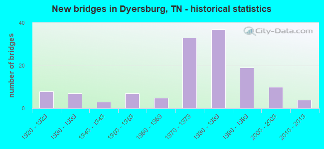
- New bridges - historical statistics
- 81920-1929
- 71930-1939
- 31940-1949
- 71950-1959
- 51960-1969
- 331970-1979
- 371980-1989
- 191990-1999
- 102000-2009
- 42010-2019
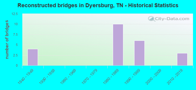
- Reconstructed bridges - Historical Statistics
- 41940-1949
- 01950-1959
- 01960-1969
- 01970-1979
- 101980-1989
- 61990-1999
- 02000-2009
- 32010-2019
- Bridge Condition - Deck
- 3.3%Very good
- 47.8%Good
- 35.6%Satisfactory
- 12.2%Fair
- 1.1%Serious
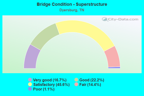
- Bridge Condition - Superstructure
- 16.7%Very good
- 22.2%Good
- 45.6%Satisfactory
- 14.4%Fair
- 1.1%Poor
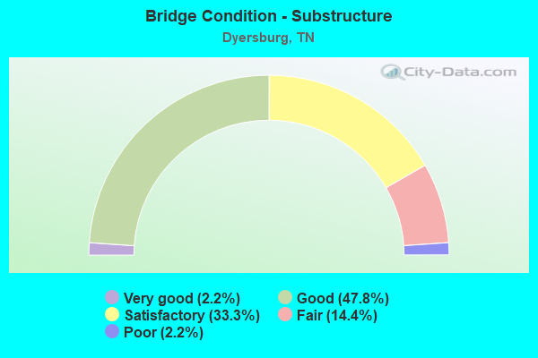
- Bridge Condition - Substructure
- 2.2%Very good
- 47.8%Good
- 33.3%Satisfactory
- 14.4%Fair
- 2.2%Poor
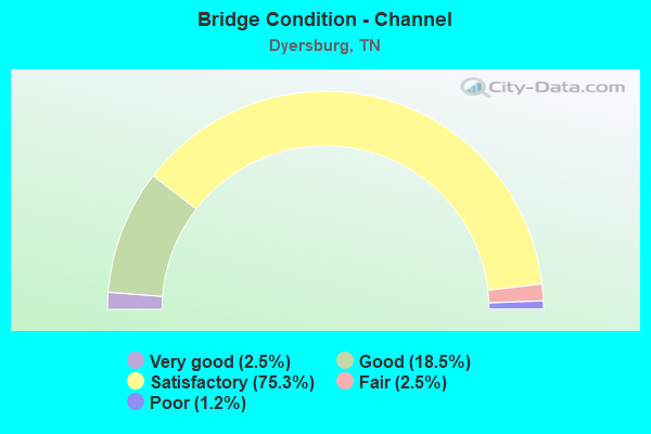
- Bridge Condition - Channel
- 2.5%Very good
- 18.5%Good
- 75.3%Satisfactory
- 2.5%Fair
- 1.2%Poor
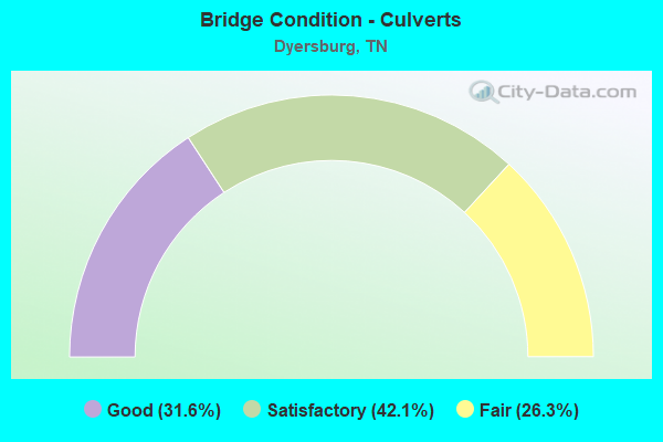
- Bridge Condition - Culverts
- 31.6%Good
- 42.1%Satisfactory
- 26.3%Fair
Find on map >> Show street view
Structure Number: 23SR0200017, Location: 1.9 M W JCT SR20&SR78 (Lat: 36.036083, Lng: -89.426361), Route carried "on" structure: State highway 104, Year Built: 1920, Year Reconstructed: 1992, Status: Open, Structure Length: 1.22m (4.00ft), Average Daily Traffic: 7,384 (year 2020), Truck Traffic: 3%, Average Future Daily Traffic: 7,856 (year 2041), Design Load: H 15, Features Intersected: BRANCH
Minimum Vertical Clearance: 30+ m (98+ ft), Kilometerpoint: 23.319, Lanes on structure: 2, Owner: State Highway Agency, Approaching Roadway Width: 8.5m (27.9ft), Material/Design: Concrete, Design/Construction: Arch - Deck, Number Of Spans In Main Unit: 1, Length of Maximum Span: 11.9m (39.0ft), Curb-To-Curb Width: 8.8m (28.9ft), Out-to-Out Width: 9.4m (30.8ft)
Condition: Deck: Satisfactory, Superstructure: Satisfactory, Substructure: Fair, Channel: Satisfactory, Operating Rating: 36.0 metric tons, Method Used To Determine Operating Rating: Field evaluation and documented engineering judgment, Inventory Rating: 24.3 metric tons, Method Used To Determine Inventory Rating: Field evaluation and documented engineering judgment, Structural Evaluation: Somewhat better than minimum adequacy, Deck Geometry: High priority of replacement, Waterway Adequacy: Equal to present desirable criteria, Approach Roadway Alignment: Equal to present desirable criteria, Length Of Structure Improvement: 1.89m (6.20ft), Designated Inspection Frequency: Every 24 months, Inspection Date: October 2021, Bridge Improvement Cost: $522,000, Roadway Improvement Cost: $53,000, Total Project Cost: $784,000 ( Estimate for 2021), Deck Structure Type: Concrete Cast-file-Place, Wearing Surface/Protective System: Wearing Surface: Bituminous
Find on map >> Show street view
Structure Number: 23SR0200019, Location: 0.3 M E JCT SR20&SR210 (Lat: 35.975833, Lng: -89.386444), Route carried "on" structure: State highway 210, Year Built: 2000, Status: Open, Structure Length: 4.91m (16.11ft), Average Daily Traffic: 4,631 (year 2020), Truck Traffic: 4%, Average Future Daily Traffic: 7,410 (year 2042), Design Load: HS 20, Features Intersected: ILLINOIS CENTRAL RR
Minimum Vertical Clearance: 30+ m (98+ ft), Kilometerpoint: 5.633, Lanes on structure: 2, Owner: State Highway Agency, Approaching Roadway Width: 11.6m (38.1ft), Material/Design: Prestressed concrete continuous, Design/Construction: Box Beam or Girders - Single/Spread, Number Of Spans In Main Unit: 4, Length of Maximum Span: 20.4m (66.9ft), Curb-To-Curb Width: 12.0m (39.4ft), Out-to-Out Width: 12.6m (41.3ft)
Condition: Deck: Good, Superstructure: Very good, Substructure: Good, Operating Rating: 73.8 metric tons, Method Used To Determine Operating Rating: Load Factor (LF), Inventory Rating: 32.4 metric tons, Method Used To Determine Inventory Rating: Load Factor (LF), Structural Evaluation: Better than present minimum criteria, Deck Geometry: Somewhat better than minimum adequacy, Underclear: Equal to present minimum criteria, Approach Roadway Alignment: Equal to present desirable criteria, Designated Inspection Frequency: Every 24 months, Inspection Date: October 2021, Deck Structure Type: Concrete Precast Panels, Wearing Surface/Protective System: Wearing Surface: Monolithic Concrete, Deck Protection: Epoxy Coated Reinforcing
Find on map >> Show street view
Structure Number: 23SR0200021, Location: 1.6 M E JCT SR20&SR210 (Lat: 35.972417, Lng: -89.363917), Route carried "on" structure: State highway 210, Year Built: 2005, Status: Open, Structure Length: 17.67m (57.97ft), Average Daily Traffic: 4,631 (year 2020), Truck Traffic: 4%, Average Future Daily Traffic: 7,520 (year 2040), Design Load: HS 20, Features Intersected: POND CREEK
Minimum Vertical Clearance: 30+ m (98+ ft), Kilometerpoint: 7.644, Lanes on structure: 2, Owner: State Highway Agency, Approaching Roadway Width: 11.9m (39.0ft), Skew: 6 degrees, Material/Design: Steel continuous, Design/Construction: Stringer/Multi-beam, Number Of Spans In Main Unit: 5, Length of Maximum Span: 40.3m (132.2ft), Curb-To-Curb Width: 11.9m (39.0ft), Out-to-Out Width: 12.6m (41.3ft)
Condition: Deck: Satisfactory, Superstructure: Good, Substructure: Good, Channel: Satisfactory, Operating Rating: 45.0 metric tons, Method Used To Determine Operating Rating: Load Factor (LF), Inventory Rating: 27.0 metric tons, Method Used To Determine Inventory Rating: Load Factor (LF), Structural Evaluation: Equal to present minimum criteria, Deck Geometry: Somewhat better than minimum adequacy, Waterway Adequacy: Better than present minimum criteria, Approach Roadway Alignment: Equal to present desirable criteria, Designated Inspection Frequency: Every 24 months, Inspection Date: October 2021, Deck Structure Type: Concrete Precast Panels, Wearing Surface/Protective System: Wearing Surface: Monolithic Concrete, Deck Protection: Epoxy Coated Reinforcing
Find on map >> Show street view
Structure Number: 23SR0200023, Location: NEAR EVANSVILLE (Lat: 36.034194, Lng: -89.439333), Route carried "on" structure: State highway 104, Year Built: 1940, Year Reconstructed: 1992, Status: Open, Structure Length: 0.67m (2.20ft), Average Daily Traffic: 7,384 (year 2020), Truck Traffic: 3%, Average Future Daily Traffic: 11,814 (year 2042), Features Intersected: BRANCH
Minimum Vertical Clearance: 30+ m (98+ ft), Kilometerpoint: 22.064, Lanes on structure: 2, Owner: State Highway Agency, Approaching Roadway Width: 11.0m (36.1ft), Skew: 4 degrees, Material/Design: Concrete, Design/Construction: Slab, Number Of Spans In Main Unit: 1, Length of Maximum Span: 6.4m (21.0ft), Curb-To-Curb Width: 8.5m (27.9ft), Out-to-Out Width: 9.9m (32.5ft)
Condition: Deck: Satisfactory, Superstructure: Satisfactory, Substructure: Satisfactory, Channel: Satisfactory, Operating Rating: 36.0 metric tons, Method Used To Determine Operating Rating: Load Factor (LF), Inventory Rating: 24.3 metric tons, Method Used To Determine Inventory Rating: Load Factor (LF), Structural Evaluation: Equal to present minimum criteria, Deck Geometry: High priority of replacement, Waterway Adequacy: Equal to present desirable criteria, Approach Roadway Alignment: Equal to present desirable criteria, Length Of Structure Improvement: 0.67m (2.20ft), Designated Inspection Frequency: Every 24 months, Inspection Date: October 2021, Bridge Improvement Cost: $86,000, Roadway Improvement Cost: $9,000, Total Project Cost: $130,000 ( Estimate for 2022), Deck Structure Type: Concrete Cast-file-Place, Wearing Surface/Protective System: Wearing Surface: Bituminous, Membrane: Preformed Fabric
Find on map >> Show street view
Structure Number: 23SR0200025, Location: 2.6 MI NE JCT SR3 & SR104 (Lat: 36.035806, Lng: -89.339278), Route carried "on" structure: US 412, Year Built: 1995, Status: Open, Structure Length: 7.47m (24.51ft), Average Daily Traffic: 9,892 (year 2020), Truck Traffic: 13%, Average Future Daily Traffic: 15,827 (year 2042), Design Load: HS 20, Features Intersected: LEWIS CREEK, Facility Carried by Structure: FAP 20
Minimum Vertical Clearance: 30+ m (98+ ft), Kilometerpoint: 3.565, Lanes on structure: 2, Base Highway Network: Yes, Owner: State Highway Agency, Approaching Roadway Width: 12.2m (40.0ft), Skew: 3 degrees, Material/Design: Prestressed concrete continuous, Design/Construction: Stringer/Multi-beam, Number Of Spans In Main Unit: 3, Length of Maximum Span: 25.3m (83.0ft), Curb-To-Curb Width: 12.8m (42.0ft), Out-to-Out Width: 13.4m (44.0ft)
Condition: Deck: Good, Superstructure: Satisfactory, Substructure: Satisfactory, Channel: Satisfactory, Operating Rating: 83.7 metric tons, Method Used To Determine Operating Rating: Load Factor (LF), Inventory Rating: 32.4 metric tons, Method Used To Determine Inventory Rating: Load Factor (LF), Structural Evaluation: Equal to present minimum criteria, Deck Geometry: Equal to present desirable criteria, Waterway Adequacy: Equal to present desirable criteria, Approach Roadway Alignment: Equal to present desirable criteria, Designated Inspection Frequency: Every 24 months, Inspection Date: October 2021, Deck Structure Type: Concrete Precast Panels, Wearing Surface/Protective System: Wearing Surface: Monolithic Concrete, Deck Protection: Epoxy Coated Reinforcing
Find on map >> Show street view
Structure Number: 23SR0200026, Location: 2.6 MI NE JCT SR 3 &SR104 (Lat: 36.035611, Lng: -89.339000), Route carried "on" structure: US 412, Year Built: 1985, Status: Open, Structure Length: 7.47m (24.51ft), Average Daily Traffic: 9,892 (year 2020), Truck Traffic: 13%, Average Future Daily Traffic: 15,827 (year 2042), Design Load: HS 20, Features Intersected: LEWIS CREEK, Facility Carried by Structure: FAP 20
Minimum Vertical Clearance: 30+ m (98+ ft), Kilometerpoint: 3.565, Lanes on structure: 2, Base Highway Network: Yes, Owner: State Highway Agency, Approaching Roadway Width: 11.0m (36.1ft), Skew: 3 degrees, Material/Design: Prestressed concrete continuous, Design/Construction: Stringer/Multi-beam, Number Of Spans In Main Unit: 3, Length of Maximum Span: 25.0m (82.0ft), Curb-To-Curb Width: 12.8m (42.0ft), Out-to-Out Width: 13.4m (44.0ft)
Condition: Deck: Good, Superstructure: Satisfactory, Substructure: Satisfactory, Channel: Satisfactory, Operating Rating: 59.4 metric tons, Method Used To Determine Operating Rating: Load Factor (LF), Inventory Rating: 32.4 metric tons, Method Used To Determine Inventory Rating: Load Factor (LF), Structural Evaluation: Equal to present minimum criteria, Deck Geometry: Equal to present desirable criteria, Waterway Adequacy: Equal to present desirable criteria, Approach Roadway Alignment: Equal to present desirable criteria, Designated Inspection Frequency: Every 24 months, Inspection Date: October 2021, Deck Structure Type: Concrete Precast Panels, Wearing Surface/Protective System: Wearing Surface: Monolithic Concrete, Deck Protection: Epoxy Coated Reinforcing
Find on map >> Show street view
Structure Number: 23SR0200027, Location: 3.0 MI NE JCT SR 3&SR 104 (Lat: 36.049167, Lng: -89.335111), Route carried "on" structure: US 412, Year Built: 1994, Status: Open, Structure Length: 4.85m (15.91ft), Average Daily Traffic: 9,892 (year 2020), Truck Traffic: 13%, Average Future Daily Traffic: 15,827 (year 2042), Design Load: HS 20, Features Intersected: SR 20-EB / HOGWALLOW RD, Facility Carried by Structure: FAP 20
Minimum Vertical Clearance: 30+ m (98+ ft), Kilometerpoint: 2.044, Lanes on structure: 2, Lanes under structure: 2, Base Highway Network: Yes, Owner: State Highway Agency, Approaching Roadway Width: 12.2m (40.0ft), Material/Design: Prestressed concrete continuous, Design/Construction: Stringer/Multi-beam, Number Of Spans In Main Unit: 3, Length of Maximum Span: 15.5m (50.9ft), Curb-To-Curb Width: 12.8m (42.0ft), Out-to-Out Width: 13.4m (44.0ft)
Condition: Deck: Good, Superstructure: Satisfactory, Substructure: Good, Operating Rating: 35.9 metric tons, Method Used To Determine Operating Rating: Load Factor (LF), Inventory Rating: 21.5 metric tons, Method Used To Determine Inventory Rating: Load Factor (LF), Structural Evaluation: Somewhat better than minimum adequacy, Deck Geometry: Equal to present desirable criteria, Underclear: Superior to present desirable criteria, Approach Roadway Alignment: Equal to present desirable criteria, Designated Inspection Frequency: Every 24 months, Inspection Date: October 2021, Deck Structure Type: Concrete Precast Panels, Wearing Surface/Protective System: Wearing Surface: Monolithic Concrete, Deck Protection: Epoxy Coated Reinforcing
Find on map >> Show street view
Structure Number: 23SR0200028, Location: 3.0 MI NE JCT SR 3&SR 104 (Lat: 36.049111, Lng: -89.334917), Route carried "on" structure: US 412, Year Built: 1985, Status: Open, Structure Length: 4.82m (15.81ft), Average Daily Traffic: 9,892 (year 2020), Truck Traffic: 13%, Average Future Daily Traffic: 15,827 (year 2042), Design Load: HS 20, Features Intersected: SR 20-WB / HOGWALLOW RD, Facility Carried by Structure: FAP 20
Minimum Vertical Clearance: 30+ m (98+ ft), Kilometerpoint: 2.044, Lanes on structure: 2, Lanes under structure: 2, Base Highway Network: Yes, Owner: State Highway Agency, Approaching Roadway Width: 14.0m (45.9ft), Material/Design: Prestressed concrete continuous, Design/Construction: Stringer/Multi-beam, Number Of Spans In Main Unit: 3, Length of Maximum Span: 19.5m (64.0ft), Curb-To-Curb Width: 14.6m (47.9ft), Out-to-Out Width: 15.2m (49.9ft)
Condition: Deck: Good, Superstructure: Good, Substructure: Good, Operating Rating: 55.8 metric tons, Method Used To Determine Operating Rating: Load Factor (LF), Inventory Rating: 32.4 metric tons, Method Used To Determine Inventory Rating: Load Factor (LF), Structural Evaluation: Better than present minimum criteria, Deck Geometry: Superior to present desirable criteria, Underclear: Superior to present desirable criteria, Approach Roadway Alignment: Equal to present desirable criteria, Designated Inspection Frequency: Every 24 months, Inspection Date: October 2021, Deck Structure Type: Concrete Precast Panels, Wearing Surface/Protective System: Wearing Surface: Monolithic Concrete, Deck Protection: Epoxy Coated Reinforcing
Find on map >> Show street view
Structure Number: 23SR0200029, Location: 3.2 MI NE JCT SR 3&SR104 (Lat: 36.051944, Lng: -89.335639), Route carried "on" structure: US 412, Year Built: 1994, Status: Open, Structure Length: 6.10m (20.01ft), Average Daily Traffic: 9,892 (year 2020), Truck Traffic: 13%, Average Future Daily Traffic: 15,827 (year 2042), Design Load: HS 20, Features Intersected: SR 20 EB / ICG RAILROAD, Facility Carried by Structure: FAP 20
Minimum Vertical Clearance: 30+ m (98+ ft), Kilometerpoint: 1.722, Lanes on structure: 2, Base Highway Network: Yes, Owner: State Highway Agency, Approaching Roadway Width: 12.2m (40.0ft), Skew: 2 degrees, Material/Design: Prestressed concrete continuous, Design/Construction: Stringer/Multi-beam, Number Of Spans In Main Unit: 3, Length of Maximum Span: 20.4m (66.9ft), Curb-To-Curb Width: 12.8m (42.0ft), Out-to-Out Width: 13.4m (44.0ft)
Condition: Deck: Good, Superstructure: Satisfactory, Substructure: Good, Operating Rating: 58.5 metric tons, Method Used To Determine Operating Rating: Load Factor (LF), Inventory Rating: 32.4 metric tons, Method Used To Determine Inventory Rating: Load Factor (LF), Structural Evaluation: Equal to present minimum criteria, Deck Geometry: Equal to present desirable criteria, Underclear: Equal to present desirable criteria, Approach Roadway Alignment: Equal to present desirable criteria, Designated Inspection Frequency: Every 24 months, Inspection Date: October 2021, Deck Structure Type: Concrete Precast Panels, Wearing Surface/Protective System: Wearing Surface: Monolithic Concrete, Deck Protection: Epoxy Coated Reinforcing
Find on map >> Show street view
Structure Number: 23SR020003, Location: 3.2 MI NE JCT SR 3&SR 104 (Lat: 36.052139, Lng: -89.335389), Route carried "on" structure: US 412, Year Built: 1985, Status: Open, Structure Length: 5.97m (19.59ft), Average Daily Traffic: 9,892 (year 2020), Truck Traffic: 13%, Average Future Daily Traffic: 15,827 (year 2042), Design Load: HS 20, Features Intersected: SR 20 WB / ICG RAILROAD, Facility Carried by Structure: FAP 20
Minimum Vertical Clearance: 30+ m (98+ ft), Kilometerpoint: 1.722, Lanes on structure: 2, Base Highway Network: Yes, Owner: State Highway Agency, Approaching Roadway Width: 14.0m (45.9ft), Skew: 2 degrees, Material/Design: Prestressed concrete continuous, Design/Construction: Stringer/Multi-beam, Number Of Spans In Main Unit: 3, Length of Maximum Span: 20.1m (65.9ft), Curb-To-Curb Width: 14.6m (47.9ft), Out-to-Out Width: 15.2m (49.9ft)
Condition: Deck: Fair, Superstructure: Satisfactory, Substructure: Satisfactory, Operating Rating: 77.4 metric tons, Method Used To Determine Operating Rating: Load Factor (LF), Inventory Rating: 32.4 metric tons, Method Used To Determine Inventory Rating: Load Factor (LF), Structural Evaluation: Equal to present minimum criteria, Deck Geometry: Superior to present desirable criteria, Underclear: Equal to present desirable criteria, Approach Roadway Alignment: Equal to present desirable criteria, Designated Inspection Frequency: Every 24 months, Inspection Date: October 2021, Deck Structure Type: Concrete Precast Panels, Wearing Surface/Protective System: Wearing Surface: Monolithic Concrete, Deck Protection: Epoxy Coated Reinforcing
Find on map >> Show street view
Structure Number: 23SR0200031, Location: 3.5 MI SE JCT SR3&SR78 (Lat: 36.025583, Lng: -89.340639), Route carried "on" structure: State highway 20, Year Built: 1986, Status: Open, Structure Length: 5.94m (19.49ft), Average Daily Traffic: 9,892 (year 2020), Truck Traffic: 13%, Average Future Daily Traffic: 15,827 (year 2042), Design Load: HS 20, Features Intersected: SR 20 / SR 104
Minimum Vertical Clearance: 30+ m (98+ ft), Kilometerpoint: 4.715, Lanes on structure: 2, Lanes under structure: 2, Base Highway Network: Yes, Owner: State Highway Agency, Approaching Roadway Width: 13.4m (44.0ft), Skew: 1 degrees, Material/Design: Prestressed concrete continuous, Design/Construction: Box Beam or Girders - Single/Spread, Number Of Spans In Main Unit: 3, Length of Maximum Span: 33.8m (110.9ft), Curb-To-Curb Width: 12.8m (42.0ft), Out-to-Out Width: 13.6m (44.6ft)
Condition: Deck: Satisfactory, Superstructure: Fair, Substructure: Good, Operating Rating: 63.0 metric tons, Method Used To Determine Operating Rating: Load Factor (LF), Inventory Rating: 32.4 metric tons, Method Used To Determine Inventory Rating: Load Factor (LF), Structural Evaluation: Somewhat better than minimum adequacy, Deck Geometry: Equal to present desirable criteria, Underclear: Better than present minimum criteria, Approach Roadway Alignment: Equal to present desirable criteria, Designated Inspection Frequency: Every 24 months, Inspection Date: October 2021, Deck Structure Type: Concrete Cast-file-Place, Wearing Surface/Protective System: Wearing Surface: Monolithic Concrete, Deck Protection: Epoxy Coated Reinforcing
Find on map >> Show street view
Structure Number: 23SR0200032, Location: 3.5 MI SE JCT SR3&SR78 (Lat: 36.025583, Lng: -89.340361), Route carried "on" structure: State highway 20, Year Built: 1986, Status: Open, Structure Length: 5.94m (19.49ft), Average Daily Traffic: 9,892 (year 2020), Truck Traffic: 13%, Average Future Daily Traffic: 15,827 (year 2042), Design Load: HS 20, Features Intersected: SR 20 / SR 104
Minimum Vertical Clearance: 30+ m (98+ ft), Kilometerpoint: 4.715, Lanes on structure: 2, Lanes under structure: 2, Base Highway Network: Yes, Owner: State Highway Agency, Approaching Roadway Width: 13.4m (44.0ft), Skew: 1 degrees, Material/Design: Prestressed concrete continuous, Design/Construction: Box Beam or Girders - Single/Spread, Number Of Spans In Main Unit: 3, Length of Maximum Span: 33.8m (110.9ft), Curb-To-Curb Width: 12.8m (42.0ft), Out-to-Out Width: 13.6m (44.6ft)
Condition: Deck: Satisfactory, Superstructure: Satisfactory, Substructure: Good, Operating Rating: 63.0 metric tons, Method Used To Determine Operating Rating: Load Factor (LF), Inventory Rating: 32.4 metric tons, Method Used To Determine Inventory Rating: Load Factor (LF), Structural Evaluation: Equal to present minimum criteria, Deck Geometry: Somewhat better than minimum adequacy, Underclear: Better than present minimum criteria, Approach Roadway Alignment: Equal to present desirable criteria, Designated Inspection Frequency: Every 24 months, Inspection Date: October 2021, Deck Structure Type: Concrete Cast-file-Place, Wearing Surface/Protective System: Wearing Surface: Monolithic Concrete
Find on map >> Show street view
Structure Number: 23SR0200033, Location: 4.1 MI SE JCT SR3&SR78 (Lat: 36.017750, Lng: -89.341111), Route carried "on" structure: State highway 20, Year Built: 1986, Status: Open, Structure Length: 10.52m (34.51ft), Average Daily Traffic: 13,332 (year 2020), Truck Traffic: 13%, Average Future Daily Traffic: 21,331 (year 2042), Design Load: HS 20, Features Intersected: LEWIS CREEK
Minimum Vertical Clearance: 30+ m (98+ ft), Kilometerpoint: 5.584, Lanes on structure: 2, Base Highway Network: Yes, Owner: State Highway Agency, Approaching Roadway Width: 13.4m (44.0ft), Skew: 1 degrees, Material/Design: Prestressed concrete, Design/Construction: Stringer/Multi-beam, Number Of Spans In Main Unit: 5, Length of Maximum Span: 21.0m (68.9ft), Curb-To-Curb Width: 12.8m (42.0ft), Out-to-Out Width: 13.4m (44.0ft)
Condition: Deck: Satisfactory, Superstructure: Satisfactory, Substructure: Good, Channel: Satisfactory, Operating Rating: 74.7 metric tons, Method Used To Determine Operating Rating: Load Factor (LF), Inventory Rating: 32.4 metric tons, Method Used To Determine Inventory Rating: Load Factor (LF), Structural Evaluation: Equal to present minimum criteria, Deck Geometry: Equal to present desirable criteria, Waterway Adequacy: Better than present minimum criteria, Approach Roadway Alignment: Equal to present desirable criteria, Designated Inspection Frequency: Every 24 months, Inspection Date: October 2021, Deck Structure Type: Concrete Cast-file-Place, Wearing Surface/Protective System: Wearing Surface: Monolithic Concrete, Deck Protection: Epoxy Coated Reinforcing
Find on map >> Show street view
Structure Number: 23SR0200034, Location: 4.1 MI SE JCT SR3&SR78 (Lat: 36.017806, Lng: -89.340778), Route carried "on" structure: State highway 20, Year Built: 1986, Status: Open, Structure Length: 10.52m (34.51ft), Average Daily Traffic: 13,332 (year 2020), Truck Traffic: 13%, Average Future Daily Traffic: 21,331 (year 2042), Design Load: HS 20, Features Intersected: LEWIS CREEK
Minimum Vertical Clearance: 30+ m (98+ ft), Kilometerpoint: 5.584, Lanes on structure: 2, Base Highway Network: Yes, Owner: State Highway Agency, Approaching Roadway Width: 13.4m (44.0ft), Skew: 1 degrees, Material/Design: Prestressed concrete, Design/Construction: Stringer/Multi-beam, Number Of Spans In Main Unit: 5, Length of Maximum Span: 21.0m (68.9ft), Curb-To-Curb Width: 12.8m (42.0ft), Out-to-Out Width: 13.4m (44.0ft)
Condition: Deck: Satisfactory, Superstructure: Satisfactory, Substructure: Good, Channel: Satisfactory, Operating Rating: 74.7 metric tons, Method Used To Determine Operating Rating: Load Factor (LF), Inventory Rating: 32.4 metric tons, Method Used To Determine Inventory Rating: Load Factor (LF), Structural Evaluation: Equal to present minimum criteria, Deck Geometry: Equal to present desirable criteria, Waterway Adequacy: Equal to present minimum criteria, Approach Roadway Alignment: Equal to present desirable criteria, Designated Inspection Frequency: Every 24 months, Inspection Date: October 2021, Deck Structure Type: Concrete Cast-file-Place, Wearing Surface/Protective System: Wearing Surface: Monolithic Concrete, Deck Protection: Epoxy Coated Reinforcing
Find on map >> Show street view
Structure Number: 23SR0200035, Location: 3.5 MI SE JCT SR3 & SR211 (Lat: 35.998528, Lng: -89.342167), Route carried "on" structure: US 412, Year Built: 1994, Status: Posted for load, Structure Length: 68.95m (226.21ft), Average Daily Traffic: 13,332 (year 2020), Truck Traffic: 13%, Average Future Daily Traffic: 21,331 (year 2041), Design Load: HS 20, Features Intersected: N FORK FORKED DEER RIVER, Facility Carried by Structure: FAP 20
Minimum Vertical Clearance: 30+ m (98+ ft), Kilometerpoint: 7.725, Lanes on structure: 2, Base Highway Network: Yes, Owner: State Highway Agency, Approaching Roadway Width: 12.2m (40.0ft), Skew: 1 degrees, Material/Design: Prestressed concrete continuous, Design/Construction: Stringer/Multi-beam, Number Of Spans In Main Unit: 29, Length of Maximum Span: 23.8m (78.1ft), Curb-To-Curb Width: 13.4m (44.0ft), Out-to-Out Width: 14.0m (45.9ft)
Condition: Deck: Satisfactory, Superstructure: Poor, Substructure: Good, Channel: Satisfactory, Operating Rating: 28.8 metric tons, Method Used To Determine Operating Rating: Load Factor (LF), Inventory Rating: 17.1 metric tons, Method Used To Determine Inventory Rating: Load Factor (LF), Structural Evaluation: Meets minimum limits, Deck Geometry: Superior to present desirable criteria, Waterway Adequacy: Better than present minimum criteria, Approach Roadway Alignment: Equal to present desirable criteria, Bridge Posting: Required (Relationship of Operating Rating to Maximum Legal Load: 0.1 - 9.9% below), Length Of Structure Improvement: 68.95m (226.21ft), Designated Inspection Frequency: Every 24 months, Other Special Inspection Frequency: Every 12 months, Inspection Date: November 2021, Other Special Inspection Date: November 2021, Bridge Improvement Cost: $13,724,000, Roadway Improvement Cost: $1,373,000, Total Project Cost: $20,587,000 ( Estimate for 2021), Deck Structure Type: Concrete Precast Panels, Wearing Surface/Protective System: Wearing Surface: Monolithic Concrete, Deck Protection: Epoxy Coated Reinforcing
Find on map >> Show street view
Structure Number: 23SR0200036, Location: 3.5 MI SE JCT SR3&SR211 (Lat: 35.998417, Lng: -89.341806), Route carried "on" structure: US 412, Year Built: 1986, Status: Posted for load, Structure Length: 71.32m (233.99ft), Average Daily Traffic: 13,332 (year 2020), Truck Traffic: 13%, Average Future Daily Traffic: 22,384 (year 2040), Design Load: HS 20, Features Intersected: N FORK FORKED DEER RIVER, Facility Carried by Structure: FAP 20
Minimum Vertical Clearance: 30+ m (98+ ft), Kilometerpoint: 7.725, Lanes on structure: 2, Base Highway Network: Yes, Owner: State Highway Agency, Approaching Roadway Width: 13.4m (44.0ft), Skew: 1 degrees, Material/Design: Prestressed concrete continuous, Design/Construction: Stringer/Multi-beam, Number Of Spans In Main Unit: 29, Length of Maximum Span: 23.8m (78.1ft), Curb-To-Curb Width: 13.4m (44.0ft), Out-to-Out Width: 14.0m (45.9ft)
Condition: Deck: Satisfactory, Superstructure: Fair, Substructure: Fair, Channel: Good, Operating Rating: 72.0 metric tons, Method Used To Determine Operating Rating: Load Factor (LF), Inventory Rating: 32.4 metric tons, Method Used To Determine Inventory Rating: Load Factor (LF), Structural Evaluation: Somewhat better than minimum adequacy, Deck Geometry: Superior to present desirable criteria, Waterway Adequacy: Better than present minimum criteria, Approach Roadway Alignment: Equal to present desirable criteria, Designated Inspection Frequency: Every 24 months, Inspection Date: December 2021, Deck Structure Type: Concrete Precast Panels, Wearing Surface/Protective System: Wearing Surface: Monolithic Concrete, Deck Protection: Epoxy Coated Reinforcing
Find on map >> Show street view
Structure Number: 23SR0200037, Location: 3.9 MI SE JCT SR3 & SR211 (Lat: 35.989361, Lng: -89.342639), Route carried "on" structure: US 412, Year Built: 1995, Status: Open, Structure Length: 11.89m (39.01ft), Average Daily Traffic: 13,332 (year 2020), Truck Traffic: 13%, Average Future Daily Traffic: 22,384 (year 2040), Design Load: HS 20, Features Intersected: OVERFLOW, Facility Carried by Structure: FAP 20
Minimum Vertical Clearance: 30+ m (98+ ft), Kilometerpoint: 8.739, Lanes on structure: 2, Base Highway Network: Yes, Owner: State Highway Agency, Approaching Roadway Width: 13.4m (44.0ft), Skew: 1 degrees, Material/Design: Prestressed concrete continuous, Design/Construction: Stringer/Multi-beam, Number Of Spans In Main Unit: 5, Length of Maximum Span: 23.8m (78.1ft), Curb-To-Curb Width: 12.8m (42.0ft), Out-to-Out Width: 13.4m (44.0ft)
Condition: Deck: Satisfactory, Superstructure: Satisfactory, Substructure: Good, Channel: Satisfactory, Operating Rating: 74.7 metric tons, Method Used To Determine Operating Rating: Load Factor (LF), Inventory Rating: 32.4 metric tons, Method Used To Determine Inventory Rating: Load Factor (LF), Structural Evaluation: Equal to present minimum criteria, Deck Geometry: Equal to present desirable criteria, Waterway Adequacy: Better than present minimum criteria, Approach Roadway Alignment: Equal to present desirable criteria, Designated Inspection Frequency: Every 24 months, Inspection Date: October 2021, Deck Structure Type: Concrete Precast Panels, Wearing Surface/Protective System: Wearing Surface: Monolithic Concrete, Deck Protection: Epoxy Coated Reinforcing
Find on map >> Show street view
Structure Number: 23SR0200038, Location: 3.9 MI SE JCT SR3&211 (Lat: 35.989361, Lng: -89.342389), Route carried "on" structure: US 412, Year Built: 1986, Status: Open, Structure Length: 11.89m (39.01ft), Average Daily Traffic: 13,332 (year 2020), Truck Traffic: 13%, Average Future Daily Traffic: 21,331 (year 2042), Design Load: HS 20, Features Intersected: OVERFLOW, Facility Carried by Structure: FAP 20
Minimum Vertical Clearance: 30+ m (98+ ft), Kilometerpoint: 8.739, Lanes on structure: 2, Base Highway Network: Yes, Owner: State Highway Agency, Approaching Roadway Width: 13.4m (44.0ft), Skew: 1 degrees, Material/Design: Prestressed concrete, Design/Construction: Stringer/Multi-beam, Number Of Spans In Main Unit: 5, Length of Maximum Span: 23.8m (78.1ft), Curb-To-Curb Width: 13.4m (44.0ft), Out-to-Out Width: 14.2m (46.6ft)
Condition: Deck: Fair, Superstructure: Fair, Substructure: Satisfactory, Channel: Satisfactory, Operating Rating: 72.9 metric tons, Method Used To Determine Operating Rating: Load Factor (LF), Inventory Rating: 32.4 metric tons, Method Used To Determine Inventory Rating: Load Factor (LF), Structural Evaluation: Somewhat better than minimum adequacy, Deck Geometry: Superior to present desirable criteria, Waterway Adequacy: Better than present minimum criteria, Approach Roadway Alignment: Equal to present desirable criteria, Designated Inspection Frequency: Every 24 months, Inspection Date: October 2021, Deck Structure Type: Concrete Precast Panels, Wearing Surface/Protective System: Wearing Surface: Monolithic Concrete, Deck Protection: Epoxy Coated Reinforcing
Find on map >> Show street view
Structure Number: 23SR0200039, Location: 3.5 MI E OF SR3 JCT (Lat: 35.965472, Lng: -89.331250), Route carried "on" structure: State highway 210, Year Built: 1996, Status: Open, Structure Length: 8.47m (27.79ft), Average Daily Traffic: 4,631 (year 2020), Truck Traffic: 4%, Average Future Daily Traffic: 7,410 (year 2042), Design Load: HS 20, Features Intersected: SR 20
Minimum Vertical Clearance: 30+ m (98+ ft), Kilometerpoint: 10.767, Lanes on structure: 3, Lanes under structure: 4, Owner: State Highway Agency, Approaching Roadway Width: 17.1m (56.1ft), Skew: 4 degrees, Material/Design: Prestressed concrete continuous, Design/Construction: Stringer/Multi-beam, Number Of Spans In Main Unit: 2, Length of Maximum Span: 42.4m (139.1ft), Curb-To-Curb Width: 17.1m (56.1ft), Out-to-Out Width: 17.7m (58.1ft)
Condition: Deck: Satisfactory, Superstructure: Satisfactory, Substructure: Good, Operating Rating: 48.6 metric tons, Method Used To Determine Operating Rating: Load Factor (LF), Inventory Rating: 27.9 metric tons, Method Used To Determine Inventory Rating: Load Factor (LF), Structural Evaluation: Equal to present minimum criteria, Deck Geometry: Superior to present desirable criteria, Underclear: Equal to present desirable criteria, Approach Roadway Alignment: Equal to present desirable criteria, Designated Inspection Frequency: Every 24 months, Inspection Date: October 2021, Deck Structure Type: Concrete Precast Panels, Wearing Surface/Protective System: Wearing Surface: Monolithic Concrete, Deck Protection: Epoxy Coated Reinforcing
Find on map >> Show street view
Structure Number: 23SR0780001, Location: 0.3 M N JCT SR78&I155 (Lat: 36.072306, Lng: -89.397000), Route carried "on" structure: State highway 78, Year Built: 1979, Year Reconstructed: 2004, Status: Open, Structure Length: 1.16m (3.81ft), Average Daily Traffic: 5,890 (year 2020), Truck Traffic: 9%, Average Future Daily Traffic: 9,424 (year 2042), Design Load: HS 20, Features Intersected: LEWIS CREEK
Minimum Vertical Clearance: 30+ m (98+ ft), Kilometerpoint: 4.184, Lanes on structure: 4, Base Highway Network: Yes, Owner: State Highway Agency, Approaching Roadway Width: 31.0m (101.7ft), Skew: 2 degrees, Material/Design: Concrete continuous, Design/Construction: Culvert, Number Of Spans In Main Unit: 2, Length of Maximum Span: 4.6m (15.1ft)
Condition: Channel: Good, Culverts: Satisfactory, Operating Rating: 89.1 metric tons, Method Used To Determine Operating Rating: Load Factor (LF), Inventory Rating: 32.4 metric tons, Method Used To Determine Inventory Rating: Load Factor (LF), Structural Evaluation: Equal to present minimum criteria, Waterway Adequacy: Equal to present minimum criteria, Approach Roadway Alignment: Equal to present desirable criteria, Designated Inspection Frequency: Every 24 months, Inspection Date: October 2021
Find on map >> Show street view
Structure Number: 23SR1030001, Location: 0.4 M W JCT SR103&SR181 (Lat: 36.160639, Lng: -89.563056), Route carried "on" structure: State highway 103, Year Built: 1991, Status: Open, Structure Length: 1.80m (5.91ft), Average Daily Traffic: 453 (year 2020), Truck Traffic: 5%, Average Future Daily Traffic: 368 (year 2039), Design Load: HS 20, Features Intersected: OVERFLOW
Minimum Vertical Clearance: 30+ m (98+ ft), Kilometerpoint: 1.915, Lanes on structure: 2, Owner: State Highway Agency, Approaching Roadway Width: 6.7m (22.0ft), Material/Design: Concrete continuous, Design/Construction: Culvert, Number Of Spans In Main Unit: 3, Length of Maximum Span: 5.5m (18.0ft), Curb-To-Curb Width: 7.3m (24.0ft), Out-to-Out Width: 9.1m (29.9ft)
Condition: Channel: Good, Culverts: Good, Operating Rating: 89.1 metric tons, Method Used To Determine Operating Rating: Load Factor (LF), Inventory Rating: 32.4 metric tons, Method Used To Determine Inventory Rating: Load Factor (LF), Structural Evaluation: Better than present minimum criteria, Deck Geometry: Meets minimum limits, Waterway Adequacy: Better than present minimum criteria, Approach Roadway Alignment: Equal to present desirable criteria, Designated Inspection Frequency: Every 24 months, Inspection Date: October 2021, Deck Structure Type: Concrete Cast-file-Place, Wearing Surface/Protective System: Wearing Surface: Monolithic Concrete, Deck Protection: Epoxy Coated Reinforcing
Find on map >> Show street view
Structure Number: 23SR1040001, Location: 0.6 M. E JCT SR104&SR211 (Lat: 36.031250, Lng: -89.375194), Route carried "on" structure: State highway 104, Year Built: 1936, Year Reconstructed: 1993, Status: Open, Structure Length: 6.86m (22.51ft), Average Daily Traffic: 4,394 (year 2020), Truck Traffic: 3%, Average Future Daily Traffic: 7,030 (year 2042), Design Load: H 20, Features Intersected: ILLIONIS CENTRAL R.R.
Minimum Vertical Clearance: 30+ m (98+ ft), Kilometerpoint: 27.954, Lanes on structure: 3, Owner: State Highway Agency, Approaching Roadway Width: 12.2m (40.0ft), Skew: 5 degrees, Material/Design: Steel, Design/Construction: Stringer/Multi-beam, Number Of Spans In Main Unit: 1, Number Of Approach Spans: 6, Length of Maximum Span: 11.3m (37.1ft), Curb or Sidewalk Widths: Left: 1.8m (5.9ft), Right: 1.8m (5.9ft), Curb-To-Curb Width: 12.2m (40.0ft), Out-to-Out Width: 16.0m (52.5ft)
Condition: Deck: Fair, Superstructure: Fair, Substructure: Fair, Operating Rating: 33.3 metric tons, Method Used To Determine Operating Rating: Load Factor (LF), Inventory Rating: 19.8 metric tons, Method Used To Determine Inventory Rating: Load Factor (LF), Structural Evaluation: Somewhat better than minimum adequacy, Deck Geometry: Meets minimum limits, Underclear: High priority of replacement, Approach Roadway Alignment: Equal to present desirable criteria, Length Of Structure Improvement: 7.90m (25.92ft), Designated Inspection Frequency: Every 24 months, Inspection Date: October 2021, Bridge Improvement Cost: $2,798,000, Roadway Improvement Cost: $280,000, Total Project Cost: $4,198,000 ( Estimate for 2022), Deck Structure Type: Concrete Cast-file-Place, Wearing Surface/Protective System: Wearing Surface: Bituminous
Find on map >> Show street view
Structure Number: 23SR1040003, Location: 1.4 M E JCT SR104 &SR211 (Lat: 36.027028, Lng: -89.362667), Route carried "on" structure: State highway 104, Year Built: 1940, Status: Open, Structure Length: 0.67m (2.20ft), Average Daily Traffic: 5,347 (year 2020), Truck Traffic: 3%, Average Future Daily Traffic: 8,555 (year 2042), Design Load: H 15, Features Intersected: JONES CREEK
Minimum Vertical Clearance: 30+ m (98+ ft), Kilometerpoint: 29.161, Lanes on structure: 2, Owner: State Highway Agency, Approaching Roadway Width: 8.5m (27.9ft), Material/Design: Concrete continuous, Design/Construction: Culvert, Number Of Spans In Main Unit: 2, Length of Maximum Span: 3.0m (9.8ft), Curb-To-Curb Width: 9.5m (31.2ft), Out-to-Out Width: 10.5m (34.4ft)
Condition: Channel: Fair, Culverts: Fair, Operating Rating: 36.0 metric tons, Method Used To Determine Operating Rating: Load Factor (LF), Inventory Rating: 24.3 metric tons, Method Used To Determine Inventory Rating: Load Factor (LF), Structural Evaluation: Somewhat better than minimum adequacy, Deck Geometry: High priority of corrective action, Waterway Adequacy: Better than present minimum criteria, Approach Roadway Alignment: Equal to present desirable criteria, Length Of Structure Improvement: 0.67m (2.20ft), Designated Inspection Frequency: Every 24 months, Inspection Date: October 2021, Bridge Improvement Cost: $76,000, Roadway Improvement Cost: $8,000, Total Project Cost: $115,000 ( Estimate for 2022), Deck Structure Type: Concrete Cast-file-Place, Wearing Surface/Protective System: Wearing Surface: Bituminous
Find on map >> Show street view
Structure Number: 23SR1040005, Location: 2.9 M E JCT SR104&SR211 (Lat: 36.025694, Lng: -89.335583), Route carried "on" structure: State highway 104, Year Built: 1939, Year Reconstructed: 2015, Status: Open, Structure Length: 3.47m (11.38ft), Average Daily Traffic: 3,392 (year 2020), Truck Traffic: 9%, Average Future Daily Traffic: 5,728 (year 2040), Design Load: HS 20, Features Intersected: OVERFLOW
Minimum Vertical Clearance: 30+ m (98+ ft), Kilometerpoint: 31.656, Lanes on structure: 2, Base Highway Network: Yes (Inventory Route: 23SR1040, Subroute: 1), Owner: State Highway Agency, Approaching Roadway Width: 9.2m (30.2ft), Material/Design: Prestressed concrete, Design/Construction: Box Beam or Girders - Single/Spread, Number Of Spans In Main Unit: 4, Length of Maximum Span: 8.7m (28.5ft), Curb-To-Curb Width: 9.9m (32.5ft), Out-to-Out Width: 10.5m (34.4ft)
Condition: Deck: Good, Superstructure: Very good, Substructure: Good, Channel: Good, Operating Rating: 55.7 metric tons, Method Used To Determine Operating Rating: Load and Resistance Factor Rating (LRFR) rating reported by rating factor(RF) method using HL-93 loadings, Inventory Rating: 35.0 metric tons, Method Used To Determine Inventory Rating: Load and Resistance Factor Rating (LRFR) rating reported by rating factor(RF) method using HL-93 loadings, Structural Evaluation: Better than present minimum criteria, Deck Geometry: Meets minimum limits, Waterway Adequacy: Equal to present minimum criteria, Approach Roadway Alignment: Equal to present desirable criteria, Designated Inspection Frequency: Every 24 months, Inspection Date: October 2021, Deck Structure Type: Concrete Cast-file-Place, Wearing Surface/Protective System: Wearing Surface: Monolithic Concrete, Deck Protection: Epoxy Coated Reinforcing
Find on map >> Show street view
Structure Number: 23SR1040007, Location: 3.2 M E JCT SR104&SR211 (Lat: 36.025889, Lng: -89.330833), Route carried "on" structure: State highway 104, Year Built: 1939, Year Reconstructed: 1993, Status: Open, Structure Length: 4.79m (15.72ft), Average Daily Traffic: 3,392 (year 2020), Truck Traffic: 9%, Average Future Daily Traffic: 5,427 (year 2042), Design Load: HS 20, Features Intersected: LEWIS CREEK CANAL
Minimum Vertical Clearance: 30+ m (98+ ft), Kilometerpoint: 32.090, Lanes on structure: 2, Base Highway Network: Yes (Inventory Route: 23SR1040, Subroute: 1), Owner: State Highway Agency, Approaching Roadway Width: 11.0m (36.1ft), Material/Design: Prestressed concrete, Design/Construction: Box Beam or Girders - Single/Spread, Number Of Spans In Main Unit: 5, Length of Maximum Span: 13.1m (43.0ft), Curb-To-Curb Width: 9.8m (32.2ft), Out-to-Out Width: 10.5m (34.4ft)
Condition: Deck: Good, Superstructure: Very good, Substructure: Satisfactory, Channel: Satisfactory, Operating Rating: 77.4 metric tons, Method Used To Determine Operating Rating: Load Factor (LF), Inventory Rating: 46.8 metric tons, Method Used To Determine Inventory Rating: Load Factor (LF), Structural Evaluation: Equal to present minimum criteria, Deck Geometry: Meets minimum limits, Waterway Adequacy: Equal to present minimum criteria, Approach Roadway Alignment: Equal to present desirable criteria, Designated Inspection Frequency: Every 24 months, Inspection Date: October 2021, Deck Structure Type: Concrete Cast-file-Place
Find on map >> Show street view
Structure Number: 23SR1040009, Location: 3.3 M E JCT SR104 &SR211 (Lat: 36.025944, Lng: -89.329333), Route carried "on" structure: State highway 104, Year Built: 1939, Year Reconstructed: 2015, Status: Open, Structure Length: 4.79m (15.72ft), Average Daily Traffic: 3,392 (year 2020), Truck Traffic: 9%, Average Future Daily Traffic: 5,427 (year 2042), Design Load: HS 20, Features Intersected: LEWIS CREEK CANEL
Minimum Vertical Clearance: 30+ m (98+ ft), Kilometerpoint: 32.219, Lanes on structure: 2, Base Highway Network: Yes (Inventory Route: 23SR1040, Subroute: 1), Owner: State Highway Agency, Approaching Roadway Width: 9.2m (30.2ft), Skew: 3 degrees, Material/Design: Prestressed concrete, Design/Construction: Box Beam or Girders - Single/Spread, Number Of Spans In Main Unit: 5, Length of Maximum Span: 13.1m (43.0ft), Curb-To-Curb Width: 9.9m (32.5ft), Out-to-Out Width: 10.5m (34.4ft)
Condition: Deck: Good, Superstructure: Very good, Substructure: Satisfactory, Channel: Satisfactory, Operating Rating: 51.3 metric tons, Method Used To Determine Operating Rating: Load Factor (LF), Inventory Rating: 30.6 metric tons, Method Used To Determine Inventory Rating: Load Factor (LF), Structural Evaluation: Equal to present minimum criteria, Deck Geometry: Meets minimum limits, Waterway Adequacy: Equal to present minimum criteria, Approach Roadway Alignment: Equal to present desirable criteria, Designated Inspection Frequency: Every 24 months, Inspection Date: October 2021, Deck Structure Type: Concrete Cast-file-Place, Wearing Surface/Protective System: Wearing Surface: Monolithic Concrete, Deck Protection: Epoxy Coated Reinforcing
Find on map >> Show street view
Structure Number: 23SR1040011, Location: 6 MI.S.OF NEWBERN (Lat: 36.023806, Lng: -89.284361), Route carried "on" structure: State highway 104, Year Built: 1986, Status: Open, Structure Length: 1.86m (6.10ft), Average Daily Traffic: 3,392 (year 2020), Truck Traffic: 9%, Average Future Daily Traffic: 5,427 (year 2042), Design Load: HS 20, Features Intersected: ROELLEN CREEK
Minimum Vertical Clearance: 30+ m (98+ ft), Kilometerpoint: 36.291, Lanes on structure: 2, Base Highway Network: Yes (Inventory Route: 23SR1040, Subroute: 1), Owner: State Highway Agency, Approaching Roadway Width: 11.0m (36.1ft), Skew: 3 degrees, Material/Design: Concrete continuous, Design/Construction: Culvert, Number Of Spans In Main Unit: 3, Length of Maximum Span: 4.6m (15.1ft), Curb or Sidewalk Widths: Left: 1.2m (3.9ft), Right: 0.0m, Curb-To-Curb Width: 11.0m (36.1ft), Out-to-Out Width: 12.8m (42.0ft)
Condition: Channel: Satisfactory, Culverts: Satisfactory, Operating Rating: 87.5 metric tons, Method Used To Determine Operating Rating: Load Factor (LF), Inventory Rating: 32.4 metric tons, Method Used To Determine Inventory Rating: Load Factor (LF), Structural Evaluation: Equal to present minimum criteria, Deck Geometry: Somewhat better than minimum adequacy, Waterway Adequacy: Equal to present desirable criteria, Approach Roadway Alignment: Equal to present desirable criteria, Designated Inspection Frequency: Every 24 months, Inspection Date: October 2021, Deck Structure Type: Concrete Cast-file-Place, Wearing Surface/Protective System: Wearing Surface: Bituminous
Find on map >> Show street view
Structure Number: 23SR1820001, Location: 3.25 MI W OF DYERSBURG (Lat: 36.101861, Lng: -89.437694), Route carried "on" structure: State highway 182, Year Built: 2010, Status: Open, Structure Length: 0.98m (3.22ft), Average Daily Traffic: 946 (year 2020), Truck Traffic: 5%, Average Future Daily Traffic: 1,632 (year 2040), Design Load: HS 20, Features Intersected: COON CREEK
Minimum Vertical Clearance: 30+ m (98+ ft), Kilometerpoint: 5.939, Lanes on structure: 2, Owner: State Highway Agency, Approaching Roadway Width: 9.1m (29.9ft), Material/Design: Concrete, Design/Construction: Culvert, Number Of Spans In Main Unit: 1, Length of Maximum Span: 9.8m (32.2ft)
Condition: Channel: Good, Culverts: Good, Operating Rating: 54.1 metric tons, Method Used To Determine Operating Rating: Assigned ratings based on Load and Resistance Factor Design (LRFD) reported by rating factor (RF) using HL93 loadings, Inventory Rating: 32.4 metric tons, Method Used To Determine Inventory Rating: Assigned ratings based on Load and Resistance Factor Design (LRFD) reported by rating factor (RF) using HL93 loadings, Structural Evaluation: Better than present minimum criteria, Waterway Adequacy: Better than present minimum criteria, Approach Roadway Alignment: Equal to present minimum criteria, Designated Inspection Frequency: Every 24 months, Inspection Date: October 2021
Find on map >> Show street view
Structure Number: 23SR2110001, Location: .2 M SW JCT SR3&SR211 (Lat: 36.050528, Lng: -89.366472), Route carried "on" structure: State highway 211, Year Built: 1987, Status: Open, Structure Length: 0.85m (2.79ft), Average Daily Traffic: 4,599 (year 2020), Truck Traffic: 4%, Average Future Daily Traffic: 7,358 (year 2042), Design Load: HS 20, Features Intersected: LEWIS CREEK
Minimum Vertical Clearance: 30+ m (98+ ft), Kilometerpoint: 6.276, Lanes on structure: 4, Owner: State Highway Agency, Approaching Roadway Width: 25.6m (84.0ft), Skew: 2 degrees, Material/Design: Concrete continuous, Design/Construction: Culvert, Number Of Spans In Main Unit: 2, Length of Maximum Span: 3.7m (12.1ft), Curb-To-Curb Width: 27.1m (88.9ft), Out-to-Out Width: 28.0m (91.9ft)
Condition: Channel: Satisfactory, Culverts: Satisfactory, Operating Rating: 58.3 metric tons, Method Used To Determine Operating Rating: Load Factor (LF), Inventory Rating: 32.4 metric tons, Method Used To Determine Inventory Rating: Load Factor (LF), Structural Evaluation: Equal to present minimum criteria, Deck Geometry: Superior to present desirable criteria, Waterway Adequacy: Equal to present desirable criteria, Approach Roadway Alignment: Equal to present desirable criteria, Designated Inspection Frequency: Every 24 months, Inspection Date: October 2021, Deck Structure Type: Concrete Cast-file-Place, Wearing Surface/Protective System: Wearing Surface: Gravel
Find on map >> Show street view
Structure Number: 55S81190003, Location: 8 MI S OF US64 (Lat: 35.975583, Lng: -89.431200), Route carried "on" structure: County highway 1661, Year Built: 2007, Status: Open, Structure Length: 4.57m (14.99ft), Average Daily Traffic: 635 (year 2020), Truck Traffic: 3%, Average Future Daily Traffic: 992 (year 2040), Design Load: HS 20, Features Intersected: MOSSES CREEK
Minimum Vertical Clearance: 30+ m (98+ ft), Kilometerpoint: 5.295, Lanes on structure: 2, Owner: County Highway Agency, Approaching Roadway Width: 8.5m (27.9ft), Skew: 1 degrees, Material/Design: Prestressed concrete continuous, Design/Construction: Box Beam or Girders - Single/Spread, Number Of Spans In Main Unit: 3, Length of Maximum Span: 15.3m (50.2ft), Curb-To-Curb Width: 8.5m (27.9ft), Out-to-Out Width: 9.2m (30.2ft)
Condition: Deck: Good, Superstructure: Satisfactory, Substructure: Good, Channel: Satisfactory, Operating Rating: 53.1 metric tons, Method Used To Determine Operating Rating: Load Factor (LF), Inventory Rating: 32.4 metric tons, Method Used To Determine Inventory Rating: Load Factor (LF), Structural Evaluation: Equal to present minimum criteria, Deck Geometry: Somewhat better than minimum adequacy, Waterway Adequacy: Equal to present minimum criteria, Approach Roadway Alignment: Equal to present desirable criteria, Designated Inspection Frequency: Every 24 months, Underwater Inspection Frequency: Every 60 months, Inspection Date: June 2020, Underwater Inspection Date: August 2020, Deck Structure Type: Concrete Cast-file-Place, Wearing Surface/Protective System: Wearing Surface: Monolithic Concrete, Deck Protection: Epoxy Coated Reinforcing
Find on map >> Show street view
Structure Number: 23008270003, Location: ON NEWBERN ROAD (Lat: 36.099444, Lng: -89.276556), Route carried "under" structure: City street 827, Year Built: 1930, Structure Length: 0. m, Average Daily Traffic: 1,287 (year 2020), Truck Traffic: 3%, Features Intersected: ICG RAILROAD / NFA 827
Minimum Vertical Clearance: 3.78m (12.40ft), Kilometerpoint: 8.449, Lanes under structure: 1, Material/Design: Concrete, Design/Construction: Arch - Deck, Length of Maximum Span: 8.8m (28.9ft)
Find on map >> Show street view
Structure Number: 23029240001, Location: ON KIST AVE (Lat: 36.055917, Lng: -89.613328), Route carried "under" structure: City street 305, Year Built: 1946, Structure Length: 0. m, Average Daily Traffic: 3,080 (year 2022), Truck Traffic: 2%, Features Intersected: CN RR / FAU 2924, Facility Carried by Structure: IC RR
Minimum Vertical Clearance: 3.03m (9.94ft), Kilometerpoint: 0.225, Lanes under structure: 2, Material/Design: Concrete, Design/Construction: Slab, Length of Maximum Span: 4.3m (14.1ft)
Find on map >> Show street view
Structure Number: 23I01550017, Location: SIMPSON RD (Lat: 36.071475, Lng: -89.463792), Route carried "under" structure: Interstate 155, Year Built: 1979, Structure Length: 0. m, Average Daily Traffic: 11,123 (year 2020), Truck Traffic: 37%, Features Intersected: SIMPSON RD / I155, Facility Carried by Structure: NFA A656
Minimum Vertical Clearance: 5.36m (17.59ft), Kilometerpoint: 14.951, Lanes on structure: 2, Lanes under structure: 4, Material/Design: Concrete continuous, Design/Construction: Box Beam or Girders - Multiple, Length of Maximum Span: 41.5m (136.2ft)
Find on map >> Show street view
Structure Number: 23I01550019, Location: MCCLOUGH RD (Lat: 36.069806, Lng: -89.450833), Route carried "under" structure: Interstate 155, Year Built: 1979, Structure Length: 0. m, Average Daily Traffic: 11,123 (year 2020), Truck Traffic: 37%, Features Intersected: NFA A658 MCCLOUGH / I155, Facility Carried by Structure: NFA A658
Minimum Vertical Clearance: 5.11m (16.77ft), Kilometerpoint: 16.110, Lanes on structure: 2, Lanes under structure: 4, Material/Design: Concrete continuous, Design/Construction: Box Beam or Girders - Multiple, Length of Maximum Span: 39.6m (129.9ft)
Find on map >> Show street view
Structure Number: 23I01550021, Location: RAMBO RD (Lat: 36.069083, Lng: -89.426306), Route carried "under" structure: Interstate 155, Year Built: 1979, Structure Length: 0. m, Average Daily Traffic: 11,123 (year 2020), Truck Traffic: 37%, Features Intersected: RAMBO RD. (A657) / I155, Facility Carried by Structure: NFA A657
Minimum Vertical Clearance: 5.33m (17.49ft), Kilometerpoint: 18.330, Lanes on structure: 2, Lanes under structure: 4, Material/Design: Concrete continuous, Design/Construction: Box Beam or Girders - Multiple, Length of Maximum Span: 39.6m (129.9ft)
Find on map >> Show street view
Structure Number: 23I01550023, Location: NAUVOO RD (Lat: 36.068806, Lng: -89.418028), Route carried "under" structure: Interstate 155, Year Built: 1979, Structure Length: 0. m, Average Daily Traffic: 11,123 (year 2020), Truck Traffic: 37%, Features Intersected: NAUVOO RD. / I155
Minimum Vertical Clearance: 5.23m (17.16ft), Kilometerpoint: 19.087, Lanes on structure: 2, Lanes under structure: 4, Material/Design: Concrete continuous, Design/Construction: Box Beam or Girders - Multiple, Length of Maximum Span: 33.5m (109.9ft)
Find on map >> Show street view
Structure Number: 23I01550025, Location: NORTH DYERSBURG (Lat: 36.068583, Lng: -89.397000), Route carried "under" structure: State highway 78, Year Built: 1979, Structure Length: 0. m, Average Daily Traffic: 26,670 (year 2020), Truck Traffic: 9%, Features Intersected: I155 / SR 78, Facility Carried by Structure: I155
Minimum Vertical Clearance: 4.83m (15.85ft), Kilometerpoint: 3.750, Lanes on structure: 2, Lanes under structure: 4, Material/Design: Concrete continuous, Design/Construction: Box Beam or Girders - Single/Spread, Length of Maximum Span: 36.6m (120.1ft)
Find on map >> Show street view
Structure Number: 23I01550026, Location: NORTH DYERSBURG (Lat: 36.068833, Lng: -89.397056), Route carried "under" structure: State highway 78, Year Built: 1979, Structure Length: 0. m, Average Daily Traffic: 5,890 (year 2020), Truck Traffic: 9%, Features Intersected: I155 / SR 78, Facility Carried by Structure: I155
Minimum Vertical Clearance: 5.00m (16.40ft), Kilometerpoint: 3.782, Lanes on structure: 4, Lanes under structure: 4, Material/Design: Concrete continuous, Design/Construction: Box Beam or Girders - Single/Spread, Length of Maximum Span: 36.6m (120.1ft)
Find on map >> Show street view
Structure Number: 23I01550031, Location: MILLSFIELD RD (Lat: 36.068111, Lng: -89.379361), Route carried "under" structure: Interstate 155, Year Built: 1979, Structure Length: 0. m, Average Daily Traffic: 14,109 (year 2020), Truck Traffic: 29%, Features Intersected: MILLSFIELD RD. / I155, Facility Carried by Structure: NFA 1433 (SA 2308)
Minimum Vertical Clearance: 4.92m (16.14ft), Kilometerpoint: 22.563, Lanes on structure: 2, Lanes under structure: 4, Material/Design: Concrete continuous, Design/Construction: Box Beam or Girders - Multiple, Length of Maximum Span: 33.2m (108.9ft)
Find on map >> Show street view
Structure Number: 23I01550033, Location: HURRICANE HILL RD (Lat: 36.067972, Lng: -89.372278), Route carried "under" structure: Interstate 155, Year Built: 1979, Structure Length: 0. m, Average Daily Traffic: 14,109 (year 2020), Truck Traffic: 29%, Features Intersected: HURRICANE HILL RD / I155, Facility Carried by Structure: NFA A270
Minimum Vertical Clearance: 5.00m (16.40ft), Kilometerpoint: 23.223, Lanes on structure: 2, Lanes under structure: 4, Material/Design: Concrete continuous, Design/Construction: Box Beam or Girders - Multiple, Length of Maximum Span: 32.9m (107.9ft)
Find on map >> Show street view
Structure Number: 23I01550035, Location: JUNCTION OF I-155 & SR 3 (Lat: 36.073000, Lng: -89.347194), Route carried "under" structure: Interstate 155, Year Built: 1979, Structure Length: 0. m, Average Daily Traffic: 14,109 (year 2020), Truck Traffic: 29%, Features Intersected: SR 3 / I155, Facility Carried by Structure: FAP 3
Minimum Vertical Clearance: 5.11m (16.77ft), Kilometerpoint: 25.621, Lanes on structure: 1, Lanes under structure: 4, Material/Design: Concrete continuous, Design/Construction: Box Beam or Girders - Multiple, Length of Maximum Span: 34.7m (113.8ft)
Find on map >> Show street view
Structure Number: 23I01550036, Location: JUNCTION OF I-155 & SR 3 (Lat: 36.072861, Lng: -89.347389), Route carried "under" structure: Interstate 3, Year Built: 1979, Structure Length: 0. m, Average Daily Traffic: 13,831 (year 2020), Truck Traffic: 9%, Features Intersected: SR 3 / I155
Minimum Vertical Clearance: 5.13m (16.83ft), Kilometerpoint: 20.181, Lanes on structure: 1, Lanes under structure: 4, Material/Design: Concrete continuous, Design/Construction: Box Beam or Girders - Multiple, Length of Maximum Span: 35.4m (116.1ft)
Find on map >> Show street view
Structure Number: 23SR0030013, Location: FORT HUDSON RD (Lat: 36.075639, Lng: -89.343278), Route carried "under" structure: US 51, Year Built: 1980, Structure Length: 0. m, Average Daily Traffic: 13,831 (year 2020), Truck Traffic: 9%, Features Intersected: FORT HUDSON RD. / SR 3, Facility Carried by Structure: FAU A717
Minimum Vertical Clearance: 4.98m (16.34ft), Kilometerpoint: 20.632, Lanes on structure: 2, Lanes under structure: 4, Material/Design: Concrete continuous, Design/Construction: Box Beam or Girders - Multiple, Length of Maximum Span: 35.4m (116.1ft)
Find on map >> Show street view
Structure Number: 23SR0030015, Location: HOSS EVERETTE RD (Lat: 36.089722, Lng: -89.322972), Route carried "under" structure: US 51, Year Built: 1980, Structure Length: 0. m, Average Daily Traffic: 13,831 (year 2020), Truck Traffic: 9%, Features Intersected: HOSS EVERETT RD. / SR 3, Facility Carried by Structure: FAU A711
Minimum Vertical Clearance: 5.00m (16.40ft), Kilometerpoint: 23.030, Lanes on structure: 2, Lanes under structure: 4, Material/Design: Concrete continuous, Design/Construction: Box Beam or Girders - Multiple, Length of Maximum Span: 32.6m (107.0ft)
Find on map >> Show street view
Structure Number: 23SR0030023, Location: LANES FERRY RD (Lat: 36.112472, Lng: -89.289917), Route carried "under" structure: US 51, Year Built: 1979, Structure Length: 0. m, Average Daily Traffic: 13,831 (year 2020), Truck Traffic: 9%, Features Intersected: LANES FERRY RD. / SR 3, Facility Carried by Structure: FAU 826
Minimum Vertical Clearance: 5.05m (16.57ft), Kilometerpoint: 26.908, Lanes on structure: 2, Lanes under structure: 4, Material/Design: Concrete continuous, Design/Construction: Box Beam or Girders - Multiple, Length of Maximum Span: 40.8m (133.9ft)
Find on map >> Show street view
Structure Number: 23SR0030025, Location: JUST WEST OF NEWBERN (Lat: 36.121444, Lng: -89.281806), Route carried "under" structure: US 51, Year Built: 1979, Structure Length: 0. m, Average Daily Traffic: 11,423 (year 2020), Truck Traffic: 9%, Features Intersected: SR 77 / SR 3, Facility Carried by Structure: FAU 77
Minimum Vertical Clearance: 4.88m (16.01ft), Kilometerpoint: 28.212, Lanes on structure: 2, Lanes under structure: 4, Material/Design: Concrete continuous, Design/Construction: Box Beam or Girders - Multiple, Length of Maximum Span: 58.8m (192.9ft)
Find on map >> Show street view
Structure Number: 23SR0030029, Location: SHARPE FERRY RD (Lat: 36.139167, Lng: -89.263194), Route carried "under" structure: US 51, Year Built: 1979, Structure Length: 0. m, Average Daily Traffic: 11,423 (year 2020), Truck Traffic: 11%, Features Intersected: SHARPE FERRY RD. / SR 3, Facility Carried by Structure: FAU 1503
Minimum Vertical Clearance: 4.82m (15.81ft), Kilometerpoint: 30.771, Lanes on structure: 2, Lanes under structure: 4, Material/Design: Concrete continuous, Design/Construction: Box Beam or Girders - Multiple, Length of Maximum Span: 38.4m (126.0ft)
Find on map >> Show street view
Structure Number: 23SR0030039, Location: 0.5 MI SE JCT I155 ;SR3 (Lat: 36.066222, Lng: -89.342861), Route carried "under" structure: State highway 211, Year Built: 1984, Structure Length: 0. m, Average Daily Traffic: 7,903 (year 2020), Truck Traffic: 4%, Features Intersected: SR 3 / SR 211, Facility Carried by Structure: FAP 3
Minimum Vertical Clearance: 5.00m (16.40ft), Kilometerpoint: 6.437, Lanes on structure: 2, Lanes under structure: 5, Material/Design: Prestressed concrete, Design/Construction: Box Beam or Girders - Single/Spread, Length of Maximum Span: 30.2m (99.1ft)
Find on map >> Show street view
Structure Number: 23SR003004, Location: 0.5 MI SE JCT I155 & SR 3 (Lat: 36.065806, Lng: -89.343306), Route carried "under" structure: State highway 3, Year Built: 1984, Structure Length: 0. m, Average Daily Traffic: 9,891 (year 2020), Truck Traffic: 9%, Features Intersected: SR 3 / SR 211
Minimum Vertical Clearance: 5.16m (16.93ft), Kilometerpoint: 19.264, Lanes on structure: 2, Lanes under structure: 5, Material/Design: Prestressed concrete, Design/Construction: Box Beam or Girders - Single/Spread, Length of Maximum Span: 30.2m (99.1ft)
Find on map >> Show street view
Structure Number: 23SR0200027, Location: 3 MI NE JCT SR3 & SR104 (Lat: 36.049167, Lng: -89.335111), Route carried "under" structure: City street 2926, Year Built: 1995, Structure Length: 0. m, Average Daily Traffic: 1,004 (year 2020), Truck Traffic: 3%, Features Intersected: SR 20-EB / HOGWALLOW RD
Minimum Vertical Clearance: 5.08m (16.67ft), Kilometerpoint: 2.301, Lanes on structure: 2, Lanes under structure: 2, Material/Design: Prestressed concrete continuous, Design/Construction: Stringer/Multi-beam, Length of Maximum Span: 15.5m (50.9ft)
Find on map >> Show street view
Structure Number: 23SR0200028, Location: 3 MI NE JCT SR 3 & SR 104 (Lat: 36.049111, Lng: -89.334917), Route carried "under" structure: City street 2926, Year Built: 1985, Structure Length: 0. m, Average Daily Traffic: 1,004 (year 2020), Truck Traffic: 3%, Features Intersected: SR 20-WB / HOGWALLOW RD
Minimum Vertical Clearance: 5.97m (19.59ft), Kilometerpoint: 2.301, Lanes on structure: 2, Lanes under structure: 2, Material/Design: Prestressed concrete continuous, Design/Construction: Stringer/Multi-beam, Length of Maximum Span: 19.5m (64.0ft)
Find on map >> Show street view
Structure Number: 23SR0200031, Location: 3.5 MI SE JCT SR3&SR78 (Lat: 36.025583, Lng: -89.340639), Route carried "under" structure: State highway 104, Year Built: 1986, Structure Length: 0. m, Average Daily Traffic: 3,392 (year 2020), Truck Traffic: 9%, Features Intersected: SR 20 / SR 104, Facility Carried by Structure: FAS 20
Minimum Vertical Clearance: 5.00m (16.40ft), Kilometerpoint: 31.221, Lanes on structure: 2, Lanes under structure: 3, Material/Design: Prestressed concrete, Design/Construction: Box Beam or Girders - Single/Spread, Length of Maximum Span: 33.8m (110.9ft)