Bridge Statistics for Dyersburg, Tennessee (TN)
Condition, Traffic, Stress, Structural Evaluation, Project Costs
- National Bridge Inventory (NBI) Statistics
- 133Number of bridges
- 2,946ft / 898mTotal length
- $699,935,000Total costs
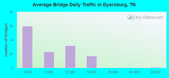
- 782,892Total average daily traffic
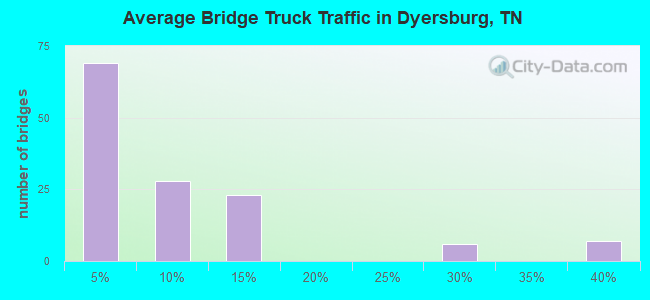
- 108,551Total average daily truck traffic
- National Bridge Inventory (NBI) Registered Bridges for Dyersburg
- No street view available for this location
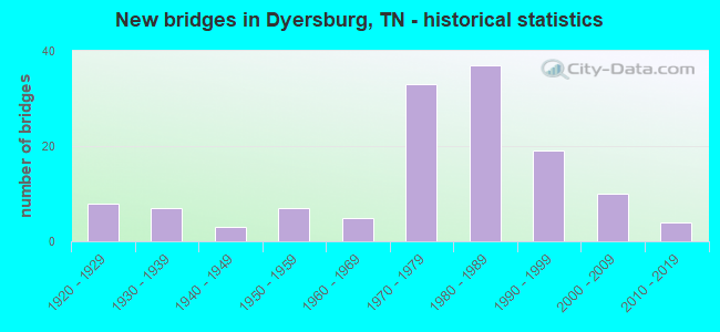
- New bridges - historical statistics
- 81920-1929
- 71930-1939
- 31940-1949
- 71950-1959
- 51960-1969
- 331970-1979
- 371980-1989
- 191990-1999
- 102000-2009
- 42010-2019
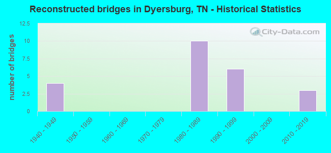
- Reconstructed bridges - Historical Statistics
- 41940-1949
- 01950-1959
- 01960-1969
- 01970-1979
- 101980-1989
- 61990-1999
- 02000-2009
- 32010-2019
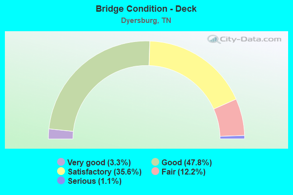
- Bridge Condition - Deck
- 3.3%Very good
- 47.8%Good
- 35.6%Satisfactory
- 12.2%Fair
- 1.1%Serious
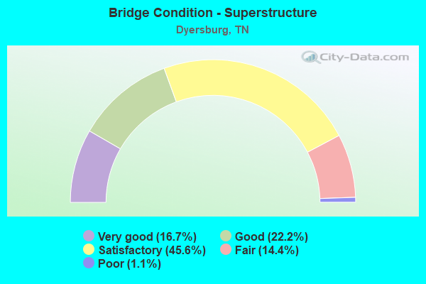
- Bridge Condition - Superstructure
- 16.7%Very good
- 22.2%Good
- 45.6%Satisfactory
- 14.4%Fair
- 1.1%Poor
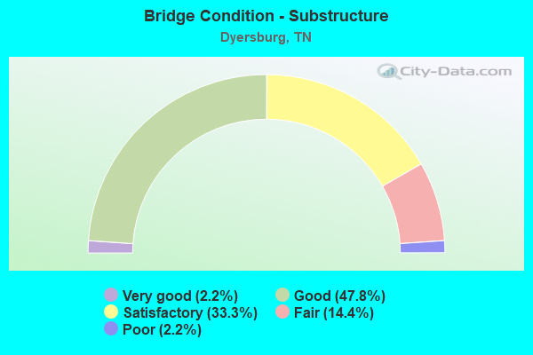
- Bridge Condition - Substructure
- 2.2%Very good
- 47.8%Good
- 33.3%Satisfactory
- 14.4%Fair
- 2.2%Poor
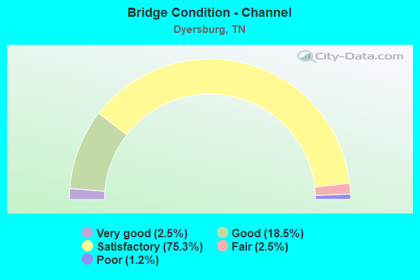
- Bridge Condition - Channel
- 2.5%Very good
- 18.5%Good
- 75.3%Satisfactory
- 2.5%Fair
- 1.2%Poor
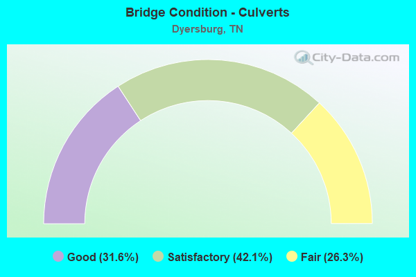
- Bridge Condition - Culverts
- 31.6%Good
- 42.1%Satisfactory
- 26.3%Fair
Find on map >> Show street view
Structure Number: 23002270001, Location: 1.2 M NE JCT SR3&SR211 (Lat: 36.077611, Lng: -89.326278), Route carried "on" structure: State highway 211, Year Built: 1923, Year Reconstructed: 1953, Status: Open, Structure Length: 1.07m (3.51ft), Average Daily Traffic: 7,903 (year 2020), Truck Traffic: 4%, Average Future Daily Traffic: 12,176 (year 2039), Design Load: HS 20, Features Intersected: BRANCH
Minimum Vertical Clearance: 30+ m (98+ ft), Kilometerpoint: 8.449, Lanes on structure: 2, Owner: State Highway Agency, Approaching Roadway Width: 10.4m (34.1ft), Material/Design: Concrete, Design/Construction: Tee Beam, Number Of Spans In Main Unit: 1, Length of Maximum Span: 10.7m (35.1ft), Curb-To-Curb Width: 8.5m (27.9ft), Out-to-Out Width: 10.5m (34.4ft)
Condition: Deck: Good, Superstructure: Very good, Substructure: Good, Channel: Good, Operating Rating: 40.5 metric tons, Method Used To Determine Operating Rating: Load Factor (LF), Inventory Rating: 29.7 metric tons, Method Used To Determine Inventory Rating: Load Factor (LF), Structural Evaluation: Better than present minimum criteria, Deck Geometry: High priority of replacement, Waterway Adequacy: Equal to present desirable criteria, Approach Roadway Alignment: Equal to present desirable criteria, Length Of Structure Improvement: 1.07m (3.51ft), Designated Inspection Frequency: Every 24 months, Inspection Date: October 2021, Bridge Improvement Cost: $114,000, Roadway Improvement Cost: $12,000, Total Project Cost: $172,000 ( Estimate for 2019), Deck Structure Type: Concrete Cast-file-Place, Wearing Surface/Protective System: Wearing Surface: Bituminous
Find on map >> Show street view
Structure Number: 23002270003, Location: 1.6 M NE JCT SR3 &SR211 (Lat: 36.081694, Lng: -89.320583), Route carried "on" structure: State highway 211, Year Built: 1923, Year Reconstructed: 1953, Status: Open, Structure Length: 1.62m (5.31ft), Average Daily Traffic: 5,012 (year 2020), Truck Traffic: 4%, Average Future Daily Traffic: 8,019 (year 2042), Design Load: HS 20, Features Intersected: BRANCH
Minimum Vertical Clearance: 30+ m (98+ ft), Kilometerpoint: 9.125, Lanes on structure: 2, Owner: State Highway Agency, Approaching Roadway Width: 10.4m (34.1ft), Skew: 4 degrees, Material/Design: Concrete, Design/Construction: Tee Beam, Number Of Spans In Main Unit: 2, Length of Maximum Span: 8.2m (26.9ft), Curb-To-Curb Width: 8.5m (27.9ft), Out-to-Out Width: 10.5m (34.4ft)
Condition: Deck: Good, Superstructure: Very good, Substructure: Fair, Channel: Poor, Operating Rating: 47.7 metric tons, Method Used To Determine Operating Rating: Load Factor (LF), Inventory Rating: 28.8 metric tons, Method Used To Determine Inventory Rating: Load Factor (LF), Structural Evaluation: Somewhat better than minimum adequacy, Deck Geometry: High priority of replacement, Waterway Adequacy: Equal to present minimum criteria, Approach Roadway Alignment: Equal to present desirable criteria, Length Of Structure Improvement: 1.62m (5.31ft), Designated Inspection Frequency: Every 24 months, Inspection Date: October 2021, Bridge Improvement Cost: $156,000, Roadway Improvement Cost: $16,000, Total Project Cost: $235,000 ( Estimate for 2022), Deck Structure Type: Concrete Cast-file-Place, Wearing Surface/Protective System: Wearing Surface: Bituminous
Find on map >> Show street view
Structure Number: 23002270005, Location: 2.0 M NE JCT SR3&SR211 (Lat: 36.085139, Lng: -89.315500), Route carried "on" structure: State highway 211, Year Built: 1923, Year Reconstructed: 2010, Status: Open, Structure Length: 0.94m (3.08ft), Average Daily Traffic: 5,012 (year 2020), Truck Traffic: 4%, Average Future Daily Traffic: 8,019 (year 2042), Design Load: HS 20, Features Intersected: BRANCH
Minimum Vertical Clearance: 30+ m (98+ ft), Kilometerpoint: 9.720, Lanes on structure: 2, Owner: State Highway Agency, Approaching Roadway Width: 10.1m (33.1ft), Skew: 4 degrees, Material/Design: Concrete, Design/Construction: Tee Beam, Number Of Spans In Main Unit: 1, Length of Maximum Span: 9.4m (30.8ft), Curb-To-Curb Width: 10.1m (33.1ft), Out-to-Out Width: 10.5m (34.4ft)
Condition: Deck: Good, Superstructure: Good, Substructure: Satisfactory, Channel: Satisfactory, Operating Rating: 42.3 metric tons, Method Used To Determine Operating Rating: Load Factor (LF), Inventory Rating: 25.2 metric tons, Method Used To Determine Inventory Rating: Load Factor (LF), Structural Evaluation: Equal to present minimum criteria, Deck Geometry: Meets minimum limits, Waterway Adequacy: Equal to present minimum criteria, Approach Roadway Alignment: Equal to present desirable criteria, Length Of Structure Improvement: 0.94m (3.08ft), Designated Inspection Frequency: Every 24 months, Inspection Date: October 2021, Bridge Improvement Cost: $102,000, Roadway Improvement Cost: $11,000, Total Project Cost: $154,000 ( Estimate for 2022), Deck Structure Type: Concrete Cast-file-Place, Wearing Surface/Protective System: Wearing Surface: Bituminous
Find on map >> Show street view
Structure Number: 23002270007, Location: 2.4 M NE JCT SR3 &SR211 (Lat: 36.088250, Lng: -89.311056), Route carried "on" structure: State highway 211, Year Built: 1922, Year Reconstructed: 1953, Status: Open, Structure Length: 0.64m (2.10ft), Average Daily Traffic: 5,012 (year 2020), Truck Traffic: 4%, Average Future Daily Traffic: 8,019 (year 2042), Design Load: HS 15, Features Intersected: BRANCH
Minimum Vertical Clearance: 30+ m (98+ ft), Kilometerpoint: 10.235, Lanes on structure: 2, Owner: State Highway Agency, Approaching Roadway Width: 10.4m (34.1ft), Material/Design: Concrete, Design/Construction: Tee Beam, Number Of Spans In Main Unit: 1, Length of Maximum Span: 6.1m (20.0ft), Curb-To-Curb Width: 8.7m (28.5ft), Out-to-Out Width: 10.7m (35.1ft)
Condition: Deck: Fair, Superstructure: Fair, Substructure: Satisfactory, Channel: Satisfactory, Operating Rating: 45.9 metric tons, Method Used To Determine Operating Rating: Load Factor (LF), Inventory Rating: 27.9 metric tons, Method Used To Determine Inventory Rating: Load Factor (LF), Structural Evaluation: Somewhat better than minimum adequacy, Deck Geometry: High priority of replacement, Waterway Adequacy: Equal to present minimum criteria, Approach Roadway Alignment: Equal to present desirable criteria, Length Of Structure Improvement: 1.26m (4.13ft), Designated Inspection Frequency: Every 24 months, Inspection Date: October 2021, Bridge Improvement Cost: $376,000, Roadway Improvement Cost: $38,000, Total Project Cost: $565,000 ( Estimate for 2022), Deck Structure Type: Concrete Cast-file-Place, Wearing Surface/Protective System: Wearing Surface: Bituminous
Find on map >> Show street view
Structure Number: 23008260011, Location: 2 MI N OF DYERSBURG (Lat: 36.094861, Lng: -89.408444), Route carried "on" structure: City street 826, Year Built: 1985, Status: Open, Structure Length: 5.18m (16.99ft), Average Daily Traffic: 1,067 (year 2020), Truck Traffic: 3%, Average Future Daily Traffic: 1,707 (year 2042), Design Load: HS 20, Features Intersected: LEWIS CREEK
Minimum Vertical Clearance: 30+ m (98+ ft), Kilometerpoint: 1.400, Lanes on structure: 2, Owner: City or Municipal Highway Agency, Approaching Roadway Width: 9.8m (32.2ft), Skew: 4 degrees, Material/Design: Prestressed concrete, Design/Construction: Stringer/Multi-beam, Number Of Spans In Main Unit: 3, Length of Maximum Span: 16.5m (54.1ft), Curb-To-Curb Width: 8.1m (26.6ft), Out-to-Out Width: 9.2m (30.2ft)
Condition: Deck: Good, Superstructure: Satisfactory, Substructure: Good, Channel: Good, Operating Rating: 57.2 metric tons, Method Used To Determine Operating Rating: Load Factor (LF), Inventory Rating: 32.4 metric tons, Method Used To Determine Inventory Rating: Load Factor (LF), Structural Evaluation: Equal to present minimum criteria, Deck Geometry: Meets minimum limits, Waterway Adequacy: Equal to present desirable criteria, Approach Roadway Alignment: Equal to present desirable criteria, Designated Inspection Frequency: Every 24 months, Inspection Date: October 2021, Deck Structure Type: Concrete Cast-file-Place, Wearing Surface/Protective System: Wearing Surface: Monolithic Concrete
Find on map >> Show street view
Structure Number: 23008270001, Location: 3.5 MI NE JCT SR20&SR104 (Lat: 36.034583, Lng: -89.279722), Route carried "on" structure: County highway 827, Year Built: 1982, Status: Posted for load, Structure Length: 1.65m (5.41ft), Average Daily Traffic: 645 (year 2020), Truck Traffic: 4%, Average Future Daily Traffic: 1,032 (year 2041), Features Intersected: BRANCH
Minimum Vertical Clearance: 30+ m (98+ ft), Kilometerpoint: 1.223, Lanes on structure: 2, Owner: County Highway Agency, Approaching Roadway Width: 7.9m (25.9ft), Material/Design: Concrete, Design/Construction: Channel Beam, Number Of Spans In Main Unit: 3, Length of Maximum Span: 5.8m (19.0ft), Curb-To-Curb Width: 6.3m (20.7ft), Out-to-Out Width: 6.6m (21.7ft)
Condition: Deck: Satisfactory, Superstructure: Satisfactory, Substructure: Poor, Channel: Satisfactory, Operating Rating: 36.0 metric tons, Method Used To Determine Operating Rating: Load Factor (LF), Inventory Rating: 25.2 metric tons, Method Used To Determine Inventory Rating: Load Factor (LF), Structural Evaluation: Meets minimum limits, Deck Geometry: High priority of corrective action, Waterway Adequacy: Equal to present minimum criteria, Approach Roadway Alignment: Equal to present desirable criteria, Length Of Structure Improvement: 1.65m (5.41ft), Designated Inspection Frequency: Every 24 months, Inspection Date: November 2021, Bridge Improvement Cost: $142,000, Roadway Improvement Cost: $15,000, Total Project Cost: $214,000 ( Estimate for 2021), Deck Structure Type: Concrete Precast Panels, Wearing Surface/Protective System: Wearing Surface: Bituminous
Find on map >> Show street view
Structure Number: 23014950001, Location: 1 MI W OF SR3 (Lat: 35.972583, Lng: -89.412278), Route carried "on" structure: County highway 1495, Year Built: 1970, Status: Open, Structure Length: 15.64m (51.31ft), Average Daily Traffic: 838 (year 2020), Truck Traffic: 3%, Average Future Daily Traffic: 1,341 (year 2042), Design Load: H 15, Features Intersected: OVERFLOW
Minimum Vertical Clearance: 30+ m (98+ ft), Kilometerpoint: 3.991, Lanes on structure: 2, Owner: County Highway Agency, Approaching Roadway Width: 9.1m (29.9ft), Material/Design: Concrete, Design/Construction: Tee Beam, Number Of Spans In Main Unit: 18, Length of Maximum Span: 8.8m (28.9ft), Curb-To-Curb Width: 7.3m (24.0ft), Out-to-Out Width: 8.7m (28.5ft)
Condition: Deck: Fair, Superstructure: Satisfactory, Substructure: Satisfactory, Channel: Satisfactory, Operating Rating: 57.6 metric tons, Method Used To Determine Operating Rating: Load Factor (LF), Inventory Rating: 32.4 metric tons, Method Used To Determine Inventory Rating: Load Factor (LF), Structural Evaluation: Equal to present minimum criteria, Deck Geometry: Meets minimum limits, Waterway Adequacy: Equal to present desirable criteria, Approach Roadway Alignment: Equal to present desirable criteria, Designated Inspection Frequency: Every 24 months, Inspection Date: October 2021, Deck Structure Type: Concrete Cast-file-Place, Wearing Surface/Protective System: Wearing Surface: Monolithic Concrete
Find on map >> Show street view
Structure Number: 23014980001, Location: 1.3 MI N OF SR20 (Lat: 36.052194, Lng: -89.473833), Route carried "on" structure: County highway 5569, Year Built: 1975, Status: Posted for load, Structure Length: 0.88m (2.89ft), Average Daily Traffic: 548 (year 2020), Truck Traffic: 5%, Average Future Daily Traffic: 877 (year 2042), Design Load: H 10, Features Intersected: BRANCH
Minimum Vertical Clearance: 30+ m (98+ ft), Kilometerpoint: 2.044, Lanes on structure: 2, Owner: County Highway Agency, Approaching Roadway Width: 6.4m (21.0ft), Material/Design: Concrete, Design/Construction: Channel Beam, Number Of Spans In Main Unit: 1, Length of Maximum Span: 8.8m (28.9ft), Curb-To-Curb Width: 6.2m (20.3ft), Out-to-Out Width: 6.6m (21.7ft)
Condition: Deck: Good, Superstructure: Satisfactory, Substructure: Satisfactory, Channel: Satisfactory, Operating Rating: 31.5 metric tons, Method Used To Determine Operating Rating: Load Factor (LF), Inventory Rating: 18.9 metric tons, Method Used To Determine Inventory Rating: Load Factor (LF), Structural Evaluation: Somewhat better than minimum adequacy, Deck Geometry: High priority of corrective action, Waterway Adequacy: Equal to present minimum criteria, Approach Roadway Alignment: Equal to present desirable criteria, Length Of Structure Improvement: 0.88m (2.89ft), Designated Inspection Frequency: Every 24 months, Inspection Date: November 2021, Bridge Improvement Cost: $89,000, Roadway Improvement Cost: $9,000, Total Project Cost: $134,000 ( Estimate for 2022), Deck Structure Type: Concrete Precast Panels, Wearing Surface/Protective System: Wearing Surface: Bituminous
Find on map >> Show street view
Structure Number: 23014980003, Location: 2 MI N OF SR20 (Lat: 36.051639, Lng: -89.461278), Route carried "on" structure: County highway 5569, Year Built: 1994, Status: Open, Structure Length: 2.74m (8.99ft), Average Daily Traffic: 548 (year 2020), Truck Traffic: 5%, Average Future Daily Traffic: 928 (year 2039), Design Load: HS 20, Features Intersected: EDWARDS CREEK
Minimum Vertical Clearance: 30+ m (98+ ft), Kilometerpoint: 3.203, Lanes on structure: 2, Owner: County Highway Agency, Approaching Roadway Width: 7.9m (25.9ft), Material/Design: Prestressed concrete, Design/Construction: Stringer/Multi-beam, Number Of Spans In Main Unit: 1, Length of Maximum Span: 27.1m (88.9ft), Curb-To-Curb Width: 8.5m (27.9ft), Out-to-Out Width: 9.1m (29.9ft)
Condition: Deck: Very good, Superstructure: Very good, Substructure: Good, Channel: Good, Operating Rating: 69.2 metric tons, Method Used To Determine Operating Rating: Load Factor (LF), Inventory Rating: 32.4 metric tons, Method Used To Determine Inventory Rating: Load Factor (LF), Structural Evaluation: Better than present minimum criteria, Deck Geometry: Somewhat better than minimum adequacy, Waterway Adequacy: Equal to present desirable criteria, Approach Roadway Alignment: Equal to present desirable criteria, Designated Inspection Frequency: Every 24 months, Inspection Date: November 2021, Deck Structure Type: Concrete Precast Panels, Wearing Surface/Protective System: Wearing Surface: Monolithic Concrete, Deck Protection: Epoxy Coated Reinforcing
Find on map >> Show street view
Structure Number: 23014980005, Location: 1 MI W OF DYERSBURG (Lat: 36.046222, Lng: -89.426361), Route carried "on" structure: County highway 5569, Year Built: 1994, Status: Open, Structure Length: 1.37m (4.49ft), Average Daily Traffic: 4,690 (year 2020), Truck Traffic: 1%, Average Future Daily Traffic: 7,504 (year 2042), Design Load: HS 20, Features Intersected: BRANCH
Minimum Vertical Clearance: 30+ m (98+ ft), Kilometerpoint: 6.421, Lanes on structure: 2, Owner: County Highway Agency, Approaching Roadway Width: 7.9m (25.9ft), Skew: 4 degrees, Material/Design: Concrete continuous, Design/Construction: Culvert, Number Of Spans In Main Unit: 2, Length of Maximum Span: 6.4m (21.0ft), Curb-To-Curb Width: 8.5m (27.9ft), Out-to-Out Width: 10.2m (33.5ft)
Condition: Channel: Good, Culverts: Satisfactory, Operating Rating: 89.1 metric tons, Method Used To Determine Operating Rating: Load Factor (LF), Inventory Rating: 32.4 metric tons, Method Used To Determine Inventory Rating: Load Factor (LF), Structural Evaluation: Equal to present minimum criteria, Deck Geometry: Meets minimum limits, Waterway Adequacy: Better than present minimum criteria, Approach Roadway Alignment: Equal to present desirable criteria, Length Of Structure Improvement: 1.37m (4.49ft), Designated Inspection Frequency: Every 24 months, Inspection Date: November 2021, Bridge Improvement Cost: $109,000, Roadway Improvement Cost: $11,000, Total Project Cost: $164,000 ( Estimate for 2022), Deck Structure Type: Concrete Cast-file-Place, Wearing Surface/Protective System: Wearing Surface: Monolithic Concrete, Deck Protection: Epoxy Coated Reinforcing
Find on map >> Show street view
Structure Number: 23057370001, Location: 1 MI W OF DYERSBURG (Lat: 36.032683, Lng: -89.404633), Route carried "on" structure: City street 5737, Year Built: 1992, Status: Open, Structure Length: 1.45m (4.76ft), Average Daily Traffic: 1,421 (year 2020), Truck Traffic: 3%, Average Future Daily Traffic: 2,512 (year 2040), Design Load: HS 20, Features Intersected: BRANCH, Facility Carried by Structure: NFA
Minimum Vertical Clearance: 30+ m (98+ ft), Kilometerpoint: 0.789, Lanes on structure: 2, Owner: County Highway Agency, Approaching Roadway Width: 9.8m (32.2ft), Skew: 2 degrees, Material/Design: Concrete continuous, Design/Construction: Culvert, Number Of Spans In Main Unit: 2, Length of Maximum Span: 7.0m (23.0ft), Curb or Sidewalk Widths: Left: 0.2m (0.7ft), Right: 0.2m (0.7ft), Curb-To-Curb Width: 9.1m (29.9ft), Out-to-Out Width: 13.7m (44.9ft)
Condition: Channel: Very good, Culverts: Good, Operating Rating: 59.4 metric tons, Method Used To Determine Operating Rating: Load Factor (LF), Inventory Rating: 36.0 metric tons, Method Used To Determine Inventory Rating: Load Factor (LF), Structural Evaluation: Better than present minimum criteria, Deck Geometry: Somewhat better than minimum adequacy, Waterway Adequacy: Equal to present desirable criteria, Approach Roadway Alignment: Equal to present desirable criteria, Designated Inspection Frequency: Every 24 months, Inspection Date: October 2021, Deck Structure Type: Concrete Cast-file-Place, Wearing Surface/Protective System: Wearing Surface: Monolithic Concrete
Find on map >> Show street view
Structure Number: 230A0730001, Location: 1.7 MI SE OF DYERSBURG (Lat: 35.996611, Lng: -89.377083), Route carried "on" structure: County highway 827, Year Built: 1988, Status: Open, Structure Length: 5.49m (18.01ft), Average Daily Traffic: 780 (year 2022), Truck Traffic: 3%, Average Future Daily Traffic: 1,248 (year 2042), Design Load: HS 20, Features Intersected: POND CREEK, Facility Carried by Structure: NFA 2941
Minimum Vertical Clearance: 30+ m (98+ ft), Kilometerpoint: 4.083, Lanes on structure: 2, Owner: County Highway Agency, Approaching Roadway Width: 9.8m (32.2ft), Material/Design: Prestressed concrete, Design/Construction: Box Beam or Girders - Single/Spread, Number Of Spans In Main Unit: 3, Length of Maximum Span: 18.3m (60.0ft), Curb-To-Curb Width: 9.1m (29.9ft), Out-to-Out Width: 9.8m (32.2ft)
Condition: Deck: Good, Superstructure: Satisfactory, Substructure: Good, Channel: Satisfactory, Operating Rating: 67.3 metric tons, Method Used To Determine Operating Rating: Load Factor (LF), Inventory Rating: 32.4 metric tons, Method Used To Determine Inventory Rating: Load Factor (LF), Structural Evaluation: Equal to present minimum criteria, Deck Geometry: Equal to present minimum criteria, Waterway Adequacy: Better than present minimum criteria, Approach Roadway Alignment: Equal to present desirable criteria, Designated Inspection Frequency: Every 24 months, Inspection Date: November 2021, Deck Structure Type: Concrete Precast Panels, Wearing Surface/Protective System: Wearing Surface: Monolithic Concrete, Deck Protection: Epoxy Coated Reinforcing
Find on map >> Show street view
Structure Number: 230A1000003, Location: 0.3 MI E OF DYERSBURG (Lat: 36.018444, Lng: -89.365000), Route carried "on" structure: County highway 100, Year Built: 1965, Status: Open, Structure Length: 0.84m (2.76ft), Average Daily Traffic: 150 (year 2022), Truck Traffic: 4%, Average Future Daily Traffic: 240 (year 2042), Design Load: H 10, Features Intersected: LEWIS CREEK
Minimum Vertical Clearance: 30+ m (98+ ft), Kilometerpoint: 1.014, Lanes on structure: 2, Owner: County Highway Agency, Approaching Roadway Width: 5.5m (18.0ft), Material/Design: Steel, Design/Construction: Stringer/Multi-beam, Number Of Spans In Main Unit: 1, Length of Maximum Span: 8.4m (27.6ft), Curb-To-Curb Width: 5.3m (17.4ft), Out-to-Out Width: 5.9m (19.4ft)
Condition: Deck: Satisfactory, Superstructure: Satisfactory, Substructure: Fair, Channel: Satisfactory, Operating Rating: 32.4 metric tons, Method Used To Determine Operating Rating: Load Factor (LF), Inventory Rating: 18.9 metric tons, Method Used To Determine Inventory Rating: Load Factor (LF), Structural Evaluation: Somewhat better than minimum adequacy, Deck Geometry: High priority of replacement, Waterway Adequacy: Equal to present minimum criteria, Approach Roadway Alignment: Equal to present desirable criteria, Length Of Structure Improvement: 0.84m (2.76ft), Designated Inspection Frequency: Every 24 months, Critical Feature Inspection Frequency: Every 24 months, Inspection Date: October 2021, Critical Feature Inspection Date: October 2021, Bridge Improvement Cost: $88,000, Roadway Improvement Cost: $9,000, Total Project Cost: $133,000 ( Estimate for 2022), Deck Structure Type: Steel plate, Wearing Surface/Protective System: Wearing Surface: Bituminous
Find on map >> Show street view
Structure Number: 230A2450001, Location: 2.1 MI NW JCT SR78&SR182 (Lat: 36.130222, Lng: -89.420472), Route carried "on" structure: County highway 2722, Year Built: 1983, Status: Open, Structure Length: 1.89m (6.20ft), Average Daily Traffic: 151 (year 2020), Truck Traffic: 3%, Average Future Daily Traffic: 242 (year 2042), Design Load: HS 20, Features Intersected: BRANCH
Minimum Vertical Clearance: 30+ m (98+ ft), Kilometerpoint: 2.012, Lanes on structure: 2, Owner: County Highway Agency, Approaching Roadway Width: 7.3m (24.0ft), Material/Design: Prestressed concrete, Design/Construction: Box Beam or Girders - Multiple, Number Of Spans In Main Unit: 1, Length of Maximum Span: 18.3m (60.0ft), Curb-To-Curb Width: 6.5m (21.3ft), Out-to-Out Width: 6.5m (21.3ft)
Condition: Deck: Satisfactory, Superstructure: Satisfactory, Substructure: Satisfactory, Channel: Satisfactory, Operating Rating: 44.1 metric tons, Method Used To Determine Operating Rating: Assigned rating based on Load Factor Design (LFD) reported in metric tons, Inventory Rating: 32.4 metric tons, Method Used To Determine Inventory Rating: Assigned rating based on Load Factor Design (LFD) reported in metric tons, Structural Evaluation: Equal to present minimum criteria, Deck Geometry: Meets minimum limits, Waterway Adequacy: Equal to present desirable criteria, Approach Roadway Alignment: Equal to present desirable criteria, Designated Inspection Frequency: Every 24 months, Inspection Date: October 2021, Deck Structure Type: Other, Wearing Surface/Protective System: Wearing Surface: Monolithic Concrete
Find on map >> Show street view
Structure Number: 230A2460001, Location: 4 MI N OF DYERSBURG (Lat: 36.120306, Lng: -89.411417), Route carried "on" structure: County highway 246, Year Built: 2003, Status: Open, Structure Length: 2.29m (7.51ft), Average Daily Traffic: 60 (year 2022), Truck Traffic: 4%, Average Future Daily Traffic: 96 (year 2040), Design Load: HS 20, Features Intersected: RUNNING CREEK
Minimum Vertical Clearance: 30+ m (98+ ft), Kilometerpoint: 0.856, Lanes on structure: 2, Owner: County Highway Agency, Approaching Roadway Width: 7.3m (24.0ft), Skew: 1 degrees, Material/Design: Prestressed concrete, Design/Construction: Stringer/Multi-beam, Number Of Spans In Main Unit: 1, Length of Maximum Span: 22.6m (74.1ft), Curb-To-Curb Width: 7.3m (24.0ft), Out-to-Out Width: 8.0m (26.2ft)
Condition: Deck: Good, Superstructure: Very good, Substructure: Good, Channel: Satisfactory, Operating Rating: 78.5 metric tons, Method Used To Determine Operating Rating: Load Factor (LF), Inventory Rating: 32.4 metric tons, Method Used To Determine Inventory Rating: Load Factor (LF), Structural Evaluation: Better than present minimum criteria, Deck Geometry: Equal to present minimum criteria, Waterway Adequacy: Equal to present desirable criteria, Approach Roadway Alignment: Equal to present desirable criteria, Designated Inspection Frequency: Every 24 months, Inspection Date: October 2021, Deck Structure Type: Concrete Cast-file-Place, Wearing Surface/Protective System: Wearing Surface: Monolithic Concrete, Deck Protection: Epoxy Coated Reinforcing
Find on map >> Show street view
Structure Number: 230A2490001, Location: 5 MI W. OF NEWBERN (Lat: 36.105222, Lng: -89.400528), Route carried "on" structure: County highway 249, Year Built: 1984, Status: Open, Structure Length: 1.04m (3.41ft), Average Daily Traffic: 40 (year 2022), Truck Traffic: 4%, Average Future Daily Traffic: 64 (year 2042), Design Load: HS 20, Features Intersected: BRANCH
Minimum Vertical Clearance: 30+ m (98+ ft), Kilometerpoint: 0.401, Lanes on structure: 2, Owner: County Highway Agency, Approaching Roadway Width: 4.3m (14.1ft), Material/Design: Concrete continuous, Design/Construction: Culvert, Number Of Spans In Main Unit: 2, Length of Maximum Span: 4.6m (15.1ft), Curb-To-Curb Width: 6.7m (22.0ft), Out-to-Out Width: 7.8m (25.6ft)
Condition: Channel: Satisfactory, Culverts: Satisfactory, Operating Rating: 89.1 metric tons, Method Used To Determine Operating Rating: Load Factor (LF), Inventory Rating: 32.4 metric tons, Method Used To Determine Inventory Rating: Load Factor (LF), Structural Evaluation: Equal to present minimum criteria, Deck Geometry: Somewhat better than minimum adequacy, Waterway Adequacy: Equal to present desirable criteria, Approach Roadway Alignment: Equal to present desirable criteria, Designated Inspection Frequency: Every 24 months, Inspection Date: October 2021, Deck Structure Type: Concrete Cast-file-Place, Wearing Surface/Protective System: Wearing Surface: Gravel
Find on map >> Show street view
Structure Number: 230A2510003, Location: 4.5 MI SE JCT SR78&SR103 (Lat: 36.124167, Lng: -89.369317), Route carried "on" structure: County highway A251, Year Built: 2005, Status: Open, Structure Length: 2.44m (8.01ft), Average Daily Traffic: 170 (year 2022), Truck Traffic: 9%, Average Future Daily Traffic: 272 (year 2042), Design Load: HS 20, Features Intersected: BRANCH
Minimum Vertical Clearance: 30+ m (98+ ft), Kilometerpoint: 1.648, Lanes on structure: 2, Owner: County Highway Agency, Approaching Roadway Width: 7.3m (24.0ft), Skew: 1 degrees, Material/Design: Prestressed concrete, Design/Construction: Stringer/Multi-beam, Number Of Spans In Main Unit: 1, Length of Maximum Span: 24.1m (79.1ft), Curb-To-Curb Width: 7.3m (24.0ft), Out-to-Out Width: 8.0m (26.2ft)
Condition: Deck: Good, Superstructure: Satisfactory, Substructure: Good, Channel: Satisfactory, Operating Rating: 81.5 metric tons, Method Used To Determine Operating Rating: Load Factor (LF), Inventory Rating: 32.4 metric tons, Method Used To Determine Inventory Rating: Load Factor (LF), Structural Evaluation: Equal to present minimum criteria, Deck Geometry: Somewhat better than minimum adequacy, Waterway Adequacy: Equal to present minimum criteria, Approach Roadway Alignment: Equal to present minimum criteria, Designated Inspection Frequency: Every 24 months, Inspection Date: October 2021, Deck Structure Type: Concrete Cast-file-Place, Wearing Surface/Protective System: Wearing Surface: Monolithic Concrete, Deck Protection: Epoxy Coated Reinforcing
Find on map >> Show street view
Structure Number: 230A2580001, Location: 4 MI W OF NEWBERN (Lat: 36.121278, Lng: -89.360333), Route carried "on" structure: County highway 251, Year Built: 1983, Status: Open, Structure Length: 1.62m (5.31ft), Average Daily Traffic: 920 (year 2022), Truck Traffic: 9%, Average Future Daily Traffic: 1,472 (year 2040), Design Load: H 15, Features Intersected: BRANCH
Minimum Vertical Clearance: 30+ m (98+ ft), Kilometerpoint: 0.536, Lanes on structure: 2, Owner: County Highway Agency, Approaching Roadway Width: 7.9m (25.9ft), Material/Design: Concrete, Design/Construction: Channel Beam, Number Of Spans In Main Unit: 3, Length of Maximum Span: 5.8m (19.0ft), Curb-To-Curb Width: 6.2m (20.3ft), Out-to-Out Width: 6.6m (21.7ft)
Condition: Deck: Satisfactory, Superstructure: Satisfactory, Substructure: Satisfactory, Channel: Satisfactory, Operating Rating: 41.4 metric tons, Method Used To Determine Operating Rating: Load Factor (LF), Inventory Rating: 25.2 metric tons, Method Used To Determine Inventory Rating: Load Factor (LF), Structural Evaluation: Equal to present minimum criteria, Deck Geometry: High priority of corrective action, Waterway Adequacy: Equal to present minimum criteria, Approach Roadway Alignment: Equal to present minimum criteria, Length Of Structure Improvement: 2.31m (7.58ft), Designated Inspection Frequency: Every 24 months, Inspection Date: October 2021, Bridge Improvement Cost: $469,000, Roadway Improvement Cost: $47,000, Total Project Cost: $704,000 ( Estimate for 2020), Deck Structure Type: Concrete Precast Panels, Wearing Surface/Protective System: Wearing Surface: Bituminous
Find on map >> Show street view
Structure Number: 230A4710001, Location: IN CITY OF FOWLKES (Lat: 35.968833, Lng: -89.386083), Route carried "on" structure: County highway 471, Year Built: 1992, Status: Open, Structure Length: 4.57m (14.99ft), Average Daily Traffic: 870 (year 2022), Truck Traffic: 4%, Average Future Daily Traffic: 1,392 (year 2040), Design Load: HS 20, Features Intersected: IC RAILROAD
Minimum Vertical Clearance: 30+ m (98+ ft), Kilometerpoint: 0.296, Lanes on structure: 2, Owner: County Highway Agency, Approaching Roadway Width: 8.5m (27.9ft), Material/Design: Prestressed concrete, Design/Construction: Box Beam or Girders - Single/Spread, Number Of Spans In Main Unit: 3, Length of Maximum Span: 16.8m (55.1ft), Curb-To-Curb Width: 8.5m (27.9ft), Out-to-Out Width: 9.1m (29.9ft)
Condition: Deck: Good, Superstructure: Very good, Substructure: Very good, Operating Rating: 84.6 metric tons, Method Used To Determine Operating Rating: Load Factor (LF), Inventory Rating: 32.4 metric tons, Method Used To Determine Inventory Rating: Load Factor (LF), Structural Evaluation: Equal to present desirable criteria, Deck Geometry: Somewhat better than minimum adequacy, Underclear: Better than present minimum criteria, Approach Roadway Alignment: Equal to present desirable criteria, Designated Inspection Frequency: Every 24 months, Inspection Date: October 2021, Deck Structure Type: Concrete Cast-file-Place, Wearing Surface/Protective System: Wearing Surface: Monolithic Concrete, Deck Protection: Epoxy Coated Reinforcing
Find on map >> Show street view
Structure Number: 230A4910001, Location: 2 MI W OF SR3 (Lat: 35.968639, Lng: -89.437583), Route carried "on" structure: County highway 491, Year Built: 1984, Status: Open, Structure Length: 1.40m (4.59ft), Average Daily Traffic: 190 (year 2022), Truck Traffic: 4%, Average Future Daily Traffic: 304 (year 2040), Design Load: HS 20, Features Intersected: BRANCH
Minimum Vertical Clearance: 30+ m (98+ ft), Kilometerpoint: 0.975, Lanes on structure: 2, Owner: County Highway Agency, Approaching Roadway Width: 7.3m (24.0ft), Skew: 4 degrees, Material/Design: Concrete continuous, Design/Construction: Culvert, Number Of Spans In Main Unit: 2, Length of Maximum Span: 4.6m (15.1ft), Curb-To-Curb Width: 6.7m (22.0ft), Out-to-Out Width: 7.8m (25.6ft)
Condition: Channel: Satisfactory, Culverts: Good, Operating Rating: 89.1 metric tons, Method Used To Determine Operating Rating: Load Factor (LF), Inventory Rating: 32.4 metric tons, Method Used To Determine Inventory Rating: Load Factor (LF), Structural Evaluation: Better than present minimum criteria, Deck Geometry: Meets minimum limits, Waterway Adequacy: Equal to present desirable criteria, Approach Roadway Alignment: Equal to present desirable criteria, Designated Inspection Frequency: Every 24 months, Inspection Date: October 2021
Find on map >> Show street view
Structure Number: 230A4920001, Location: 3 MI W OF SR3 (Lat: 35.975567, Lng: -89.431200), Route carried "on" structure: County highway 492, Year Built: 2010, Status: Open, Structure Length: 1.98m (6.50ft), Average Daily Traffic: 90 (year 2022), Truck Traffic: 2%, Average Future Daily Traffic: 144 (year 2039), Design Load: HL 93, Features Intersected: BRANCH
Minimum Vertical Clearance: 30+ m (98+ ft), Kilometerpoint: 0.821, Lanes on structure: 2, Owner: County Highway Agency, Approaching Roadway Width: 7.3m (24.0ft), Skew: 2 degrees, Material/Design: Prestressed concrete, Design/Construction: Stringer/Multi-beam, Number Of Spans In Main Unit: 1, Length of Maximum Span: 18.5m (60.7ft), Curb-To-Curb Width: 7.3m (24.0ft), Out-to-Out Width: 8.0m (26.2ft)
Condition: Deck: Satisfactory, Superstructure: Good, Substructure: Good, Channel: Satisfactory, Operating Rating: 83.9 metric tons, Method Used To Determine Operating Rating: Load Factor (LF), Inventory Rating: 32.4 metric tons, Method Used To Determine Inventory Rating: Load Factor (LF), Structural Evaluation: Better than present minimum criteria, Deck Geometry: Equal to present minimum criteria, Waterway Adequacy: Equal to present minimum criteria, Approach Roadway Alignment: Equal to present desirable criteria, Designated Inspection Frequency: Every 24 months, Inspection Date: October 2021, Deck Structure Type: Concrete Cast-file-Place, Wearing Surface/Protective System: Wearing Surface: Monolithic Concrete, Deck Protection: Epoxy Coated Reinforcing
Find on map >> Show street view
Structure Number: 230A4930001, Location: 4 MI SW OF DYERSBURG (Lat: 35.968250, Lng: -89.448417), Route carried "on" structure: County highway 493, Year Built: 1982, Status: Temporarily open, Structure Length: 0.67m (2.20ft), Average Daily Traffic: 120 (year 2022), Truck Traffic: 4%, Average Future Daily Traffic: 192 (year 2042), Features Intersected: MCBRIDE CREEK
Minimum Vertical Clearance: 30+ m (98+ ft), Kilometerpoint: 2.494, Lanes on structure: 2, Owner: County Highway Agency, Approaching Roadway Width: 5.5m (18.0ft), Skew: 1 degrees, Material/Design: Wood or Timber, Design/Construction: Stringer/Multi-beam, Number Of Spans In Main Unit: 1, Length of Maximum Span: 6.4m (21.0ft), Curb-To-Curb Width: 5.9m (19.4ft), Out-to-Out Width: 5.9m (19.4ft)
Condition: Deck: Serious, Superstructure: Satisfactory, Substructure: Poor, Channel: Satisfactory, Structural Evaluation: High priority of replacement, Deck Geometry: High priority of corrective action, Waterway Adequacy: Equal to present minimum criteria, Approach Roadway Alignment: Equal to present minimum criteria, Length Of Structure Improvement: 1.30m (4.27ft), Designated Inspection Frequency: Every 24 months, Inspection Date: October 2021, Bridge Improvement Cost: $270,000, Roadway Improvement Cost: $28,000, Total Project Cost: $406,000 ( Estimate for 2022), Deck Structure Type: Wood or Timber, Wearing Surface/Protective System: Wearing Surface: Wood or Timber
Find on map >> Show street view
Structure Number: 230A5550001, Location: 0.4 MI E OF DYERSBURG (Lat: 36.048556, Lng: -89.331778), Route carried "on" structure: City street 2926, Year Built: 2000, Status: Open, Structure Length: 0.96m (3.15ft), Average Daily Traffic: 1,004 (year 2020), Truck Traffic: 3%, Average Future Daily Traffic: 1,728 (year 2039), Design Load: HS 20, Features Intersected: HUNSACKER CREEK
Minimum Vertical Clearance: 30+ m (98+ ft), Kilometerpoint: 2.575, Lanes on structure: 2, Owner: City or Municipal Highway Agency, Approaching Roadway Width: 8.5m (27.9ft), Material/Design: Concrete, Design/Construction: Culvert, Number Of Spans In Main Unit: 1, Length of Maximum Span: 9.1m (29.9ft), Curb-To-Curb Width: 8.4m (27.6ft), Out-to-Out Width: 10.3m (33.8ft)
Condition: Channel: Satisfactory, Culverts: Good, Operating Rating: 44.1 metric tons, Method Used To Determine Operating Rating: Assigned rating based on Load Factor Design (LFD) reported in metric tons, Inventory Rating: 32.4 metric tons, Method Used To Determine Inventory Rating: Assigned rating based on Load Factor Design (LFD) reported in metric tons, Structural Evaluation: Better than present minimum criteria, Deck Geometry: Meets minimum limits, Waterway Adequacy: Equal to present desirable criteria, Approach Roadway Alignment: Equal to present desirable criteria, Designated Inspection Frequency: Every 24 months, Inspection Date: October 2021, Deck Structure Type: Concrete Cast-file-Place, Wearing Surface/Protective System: Wearing Surface: Monolithic Concrete, Deck Protection: Epoxy Coated Reinforcing
Find on map >> Show street view
Structure Number: 230A5550003, Location: 1 MI E OF DYERSBURG (Lat: 36.047861, Lng: -89.322083), Route carried "on" structure: County highway 2926, Year Built: 1999, Status: Open, Structure Length: 2.13m (6.99ft), Average Daily Traffic: 1,004 (year 2020), Truck Traffic: 3%, Average Future Daily Traffic: 1,606 (year 2042), Design Load: HS 20, Features Intersected: JONES CREEK
Minimum Vertical Clearance: 30+ m (98+ ft), Kilometerpoint: 3.444, Lanes on structure: 2, Owner: County Highway Agency, Approaching Roadway Width: 8.5m (27.9ft), Material/Design: Prestressed concrete, Design/Construction: Stringer/Multi-beam, Number Of Spans In Main Unit: 1, Length of Maximum Span: 21.0m (68.9ft), Curb-To-Curb Width: 8.5m (27.9ft), Out-to-Out Width: 9.3m (30.5ft)
Condition: Deck: Satisfactory, Superstructure: Fair, Substructure: Satisfactory, Channel: Satisfactory, Operating Rating: 74.5 metric tons, Method Used To Determine Operating Rating: Load Factor (LF), Inventory Rating: 32.4 metric tons, Method Used To Determine Inventory Rating: Load Factor (LF), Structural Evaluation: Somewhat better than minimum adequacy, Deck Geometry: Somewhat better than minimum adequacy, Waterway Adequacy: Better than present minimum criteria, Approach Roadway Alignment: Equal to present desirable criteria, Length Of Structure Improvement: 2.13m (6.99ft), Designated Inspection Frequency: Every 24 months, Inspection Date: October 2021, Bridge Improvement Cost: $411,000, Roadway Improvement Cost: $42,000, Total Project Cost: $617,000 ( Estimate for 2022), Deck Structure Type: Concrete Precast Panels, Wearing Surface/Protective System: Wearing Surface: Monolithic Concrete, Deck Protection: Epoxy Coated Reinforcing
Find on map >> Show street view
Structure Number: 230A5550009, Location: 1.5 MI E OF DYERSBURG (Lat: 36.048083, Lng: -89.313444), Route carried "on" structure: County highway 2926, Year Built: 1981, Status: Posted for load, Structure Length: 1.07m (3.51ft), Average Daily Traffic: 1,004 (year 2020), Truck Traffic: 3%, Average Future Daily Traffic: 1,606 (year 2042), Design Load: HS 20, Features Intersected: BRANCH
Minimum Vertical Clearance: 30+ m (98+ ft), Kilometerpoint: 4.265, Lanes on structure: 2, Owner: County Highway Agency, Approaching Roadway Width: 9.1m (29.9ft), Skew: 4 degrees, Material/Design: Prestressed concrete, Design/Construction: Box Beam or Girders - Multiple, Number Of Spans In Main Unit: 1, Length of Maximum Span: 10.1m (33.1ft), Curb-To-Curb Width: 8.8m (28.9ft), Out-to-Out Width: 10.2m (33.5ft)
Condition: Deck: Good, Superstructure: Good, Substructure: Satisfactory, Channel: Satisfactory, Operating Rating: 36.0 metric tons, Method Used To Determine Operating Rating: Field evaluation and documented engineering judgment, Inventory Rating: 24.3 metric tons, Method Used To Determine Inventory Rating: Field evaluation and documented engineering judgment, Structural Evaluation: Equal to present minimum criteria, Deck Geometry: Somewhat better than minimum adequacy, Waterway Adequacy: Equal to present minimum criteria, Approach Roadway Alignment: Equal to present minimum criteria, Designated Inspection Frequency: Every 24 months, Inspection Date: October 2021, Deck Structure Type: Concrete Cast-file-Place, Wearing Surface/Protective System: Wearing Surface: Bituminous
Find on map >> Show street view
Structure Number: 230A6010001, Location: 1 MI W OF DYERSBURG (Lat: 36.033028, Lng: -89.437528), Route carried "on" structure: County highway 601, Year Built: 1965, Status: Posted for load, Structure Length: 2.10m (6.89ft), Average Daily Traffic: 660 (year 2022), Truck Traffic: 4%, Average Future Daily Traffic: 1,056 (year 2042), Design Load: H 15, Features Intersected: BRANCH
Minimum Vertical Clearance: 30+ m (98+ ft), Kilometerpoint: 0.465, Lanes on structure: 2, Owner: County Highway Agency, Approaching Roadway Width: 8.5m (27.9ft), Skew: 1 degrees, Material/Design: Concrete, Design/Construction: Channel Beam, Number Of Spans In Main Unit: 3, Length of Maximum Span: 9.4m (30.8ft), Curb-To-Curb Width: 6.1m (20.0ft), Out-to-Out Width: 6.4m (21.0ft)
Condition: Deck: Satisfactory, Superstructure: Good, Substructure: Satisfactory, Channel: Satisfactory, Operating Rating: 37.8 metric tons, Method Used To Determine Operating Rating: Load Factor (LF), Inventory Rating: 22.5 metric tons, Method Used To Determine Inventory Rating: Load Factor (LF), Structural Evaluation: Equal to present minimum criteria, Deck Geometry: High priority of corrective action, Waterway Adequacy: Equal to present minimum criteria, Approach Roadway Alignment: Equal to present desirable criteria, Length Of Structure Improvement: 2.10m (6.89ft), Designated Inspection Frequency: Every 24 months, Inspection Date: October 2021, Bridge Improvement Cost: $187,000, Roadway Improvement Cost: $19,000, Total Project Cost: $281,000 ( Estimate for 2022), Deck Structure Type: Concrete Precast Panels, Wearing Surface/Protective System: Wearing Surface: Other
Find on map >> Show street view
Structure Number: 230A6670001, Location: 1 MI W OF SR78 (Lat: 36.094167, Lng: -89.427083), Route carried "on" structure: County highway 667, Year Built: 1984, Status: Open, Structure Length: 1.01m (3.31ft), Average Daily Traffic: 190 (year 2022), Truck Traffic: 6%, Average Future Daily Traffic: 304 (year 2042), Design Load: HS 20, Features Intersected: LEWIS CREEK
Minimum Vertical Clearance: 30+ m (98+ ft), Kilometerpoint: 0.517, Lanes on structure: 2, Owner: County Highway Agency, Approaching Roadway Width: 7.3m (24.0ft), Skew: 1 degrees, Material/Design: Concrete continuous, Design/Construction: Culvert, Number Of Spans In Main Unit: 2, Length of Maximum Span: 4.6m (15.1ft), Curb-To-Curb Width: 6.8m (22.3ft), Out-to-Out Width: 7.8m (25.6ft)
Condition: Channel: Satisfactory, Culverts: Satisfactory, Operating Rating: 89.1 metric tons, Method Used To Determine Operating Rating: Load Factor (LF), Inventory Rating: 32.4 metric tons, Method Used To Determine Inventory Rating: Load Factor (LF), Structural Evaluation: Equal to present minimum criteria, Deck Geometry: Meets minimum limits, Waterway Adequacy: Equal to present desirable criteria, Approach Roadway Alignment: Equal to present desirable criteria, Designated Inspection Frequency: Every 24 months, Inspection Date: October 2021
Find on map >> Show street view
Structure Number: 230A6760001, Location: 1 MI W OF SR78 (Lat: 36.091833, Lng: -89.421528), Route carried "on" structure: City street 2723, Year Built: 1994, Status: Open, Structure Length: 2.74m (8.99ft), Average Daily Traffic: 725 (year 2020), Truck Traffic: 3%, Average Future Daily Traffic: 976 (year 2039), Design Load: HS 20, Features Intersected: LEWIS CREEK
Minimum Vertical Clearance: 30+ m (98+ ft), Kilometerpoint: 5.584, Lanes on structure: 2, Owner: City or Municipal Highway Agency, Approaching Roadway Width: 7.3m (24.0ft), Material/Design: Prestressed concrete, Design/Construction: Stringer/Multi-beam, Number Of Spans In Main Unit: 1, Length of Maximum Span: 27.1m (88.9ft), Curb-To-Curb Width: 7.3m (24.0ft), Out-to-Out Width: 8.0m (26.2ft)
Condition: Deck: Very good, Superstructure: Very good, Substructure: Good, Channel: Satisfactory, Operating Rating: 79.1 metric tons, Method Used To Determine Operating Rating: Load Factor (LF), Inventory Rating: 29.7 metric tons, Method Used To Determine Inventory Rating: Load Factor (LF), Structural Evaluation: Better than present minimum criteria, Deck Geometry: Meets minimum limits, Waterway Adequacy: Equal to present desirable criteria, Approach Roadway Alignment: Equal to present desirable criteria, Designated Inspection Frequency: Every 24 months, Inspection Date: October 2021, Deck Structure Type: Concrete Precast Panels, Wearing Surface/Protective System: Wearing Surface: Monolithic Concrete, Deck Protection: Epoxy Coated Reinforcing
Find on map >> Show street view
Structure Number: 230A6870003, Location: 2 MI N OF DYERSBURG (Lat: 36.086694, Lng: -89.408722), Route carried "on" structure: County highway 687, Year Built: 2011, Status: Open, Structure Length: 2.73m (8.96ft), Average Daily Traffic: 10 (year 2022), Truck Traffic: 2%, Average Future Daily Traffic: 16 (year 2040), Features Intersected: LEWIS CREEK
Minimum Vertical Clearance: 30+ m (98+ ft), Kilometerpoint: 0.182, Lanes on structure: 2, Owner: County Highway Agency, Approaching Roadway Width: 7.3m (24.0ft), Material/Design: Steel, Design/Construction: Stringer/Multi-beam, Number Of Spans In Main Unit: 1, Length of Maximum Span: 27.3m (89.6ft), Curb-To-Curb Width: 6.0m (19.7ft), Out-to-Out Width: 6.4m (21.0ft)
Condition: Deck: Good, Superstructure: Good, Substructure: Good, Channel: Satisfactory, Operating Rating: 30.6 metric tons, Method Used To Determine Operating Rating: Load Factor (LF), Inventory Rating: 18.9 metric tons, Method Used To Determine Inventory Rating: Load Factor (LF), Structural Evaluation: Somewhat better than minimum adequacy, Deck Geometry: Meets minimum limits, Waterway Adequacy: Equal to present desirable criteria, Approach Roadway Alignment: Equal to present desirable criteria, Length Of Structure Improvement: 2.73m (8.96ft), Designated Inspection Frequency: Every 24 months, Critical Feature Inspection Frequency: Every 24 months, Inspection Date: October 2021, Critical Feature Inspection Date: October 2021, Bridge Improvement Cost: $155,000, Roadway Improvement Cost: $16,000, Total Project Cost: $233,000 ( Estimate for 2020), Deck Structure Type: Steel plate, Wearing Surface/Protective System: Wearing Surface: Other
Find on map >> Show street view
Structure Number: 230A6870005, Location: 1 MI N OF DYERSBURG (Lat: 36.072750, Lng: -89.410528), Route carried "on" structure: County highway 687, Year Built: 1999, Status: Posted for load, Structure Length: 1.73m (5.68ft), Average Daily Traffic: 10 (year 2022), Truck Traffic: 2%, Average Future Daily Traffic: 16 (year 2042), Design Load: H 15, Features Intersected: BRANCH
Minimum Vertical Clearance: 30+ m (98+ ft), Kilometerpoint: 1.733, Lanes on structure: 2, Owner: County Highway Agency, Approaching Roadway Width: 6.1m (20.0ft), Material/Design: Concrete, Design/Construction: Channel Beam, Number Of Spans In Main Unit: 3, Length of Maximum Span: 5.8m (19.0ft), Curb-To-Curb Width: 6.2m (20.3ft), Out-to-Out Width: 6.6m (21.7ft)
Condition: Deck: Very good, Superstructure: Good, Substructure: Satisfactory, Channel: Satisfactory, Operating Rating: 46.8 metric tons, Method Used To Determine Operating Rating: Load Factor (LF), Inventory Rating: 27.9 metric tons, Method Used To Determine Inventory Rating: Load Factor (LF), Structural Evaluation: Equal to present minimum criteria, Deck Geometry: Somewhat better than minimum adequacy, Waterway Adequacy: Equal to present desirable criteria, Approach Roadway Alignment: Equal to present desirable criteria, Designated Inspection Frequency: Every 24 months, Inspection Date: October 2021, Deck Structure Type: Concrete Precast Panels, Wearing Surface/Protective System: Wearing Surface: Other
Find on map >> Show street view
Structure Number: 230A7040003, Location: 2 MI N OF SR104 (Lat: 36.059000, Lng: -89.296917), Route carried "on" structure: County highway 2926, Year Built: 1981, Status: Posted for load, Structure Length: 1.07m (3.51ft), Average Daily Traffic: 1,004 (year 2020), Truck Traffic: 3%, Average Future Daily Traffic: 1,606 (year 2042), Design Load: HS 20, Features Intersected: BRANCH
Minimum Vertical Clearance: 63.17m (207.25ft), Kilometerpoint: 6.920, Lanes on structure: 2, Owner: County Highway Agency, Approaching Roadway Width: 7.9m (25.9ft), Material/Design: Prestressed concrete, Design/Construction: Box Beam or Girders - Multiple, Number Of Spans In Main Unit: 1, Length of Maximum Span: 10.7m (35.1ft), Curb-To-Curb Width: 8.3m (27.2ft), Out-to-Out Width: 9.4m (30.8ft)
Condition: Deck: Fair, Superstructure: Fair, Substructure: Good, Channel: Good, Operating Rating: 44.1 metric tons, Method Used To Determine Operating Rating: Assigned rating based on Load Factor Design (LFD) reported in metric tons, Inventory Rating: 32.4 metric tons, Method Used To Determine Inventory Rating: Assigned rating based on Load Factor Design (LFD) reported in metric tons, Structural Evaluation: Somewhat better than minimum adequacy, Deck Geometry: Meets minimum limits, Waterway Adequacy: Somewhat better than minimum adequacy, Approach Roadway Alignment: Equal to present desirable criteria, Designated Inspection Frequency: Every 24 months, Inspection Date: November 2021, Deck Structure Type: Concrete Cast-file-Place, Wearing Surface/Protective System: Wearing Surface: Bituminous
Find on map >> Show street view
Structure Number: 230A7110001, Location: 1 MI N OF SR3 (Lat: 36.101278, Lng: -89.330583), Route carried "on" structure: County highway 711, Year Built: 2003, Status: Open, Structure Length: 2.29m (7.51ft), Average Daily Traffic: 70 (year 2022), Truck Traffic: 2%, Average Future Daily Traffic: 112 (year 2039), Design Load: HS 20, Features Intersected: BRANCH
Minimum Vertical Clearance: 30+ m (98+ ft), Kilometerpoint: 0.959, Lanes on structure: 2, Owner: County Highway Agency, Approaching Roadway Width: 7.9m (25.9ft), Skew: 2 degrees, Material/Design: Prestressed concrete, Design/Construction: Stringer/Multi-beam, Number Of Spans In Main Unit: 1, Length of Maximum Span: 22.6m (74.1ft), Curb-To-Curb Width: 7.3m (24.0ft), Out-to-Out Width: 8.0m (26.2ft)
Condition: Deck: Good, Superstructure: Very good, Substructure: Very good, Channel: Satisfactory, Operating Rating: 79.2 metric tons, Method Used To Determine Operating Rating: Load Factor (LF), Inventory Rating: 32.4 metric tons, Method Used To Determine Inventory Rating: Load Factor (LF), Structural Evaluation: Equal to present desirable criteria, Deck Geometry: Equal to present minimum criteria, Waterway Adequacy: Equal to present minimum criteria, Approach Roadway Alignment: Equal to present desirable criteria, Designated Inspection Frequency: Every 24 months, Inspection Date: October 2021, Deck Structure Type: Concrete Precast Panels, Wearing Surface/Protective System: Wearing Surface: Monolithic Concrete, Deck Protection: Epoxy Coated Reinforcing
Find on map >> Show street view
Structure Number: 230A7280003, Location: 3 MI NW OF SR3 (Lat: 36.110817, Lng: -89.345483), Route carried "on" structure: County highway 2721, Year Built: 2010, Status: Open, Structure Length: 3.20m (10.50ft), Average Daily Traffic: 806 (year 2020), Truck Traffic: 2%, Average Future Daily Traffic: 1,290 (year 2042), Design Load: HL 93, Features Intersected: BRANCH
Minimum Vertical Clearance: 30+ m (98+ ft), Kilometerpoint: 1.593, Lanes on structure: 2, Owner: County Highway Agency, Approaching Roadway Width: 6.7m (22.0ft), Skew: 4 degrees, Material/Design: Prestressed concrete, Design/Construction: Stringer/Multi-beam, Number Of Spans In Main Unit: 1, Length of Maximum Span: 29.8m (97.8ft), Curb-To-Curb Width: 8.5m (27.9ft), Out-to-Out Width: 9.3m (30.5ft)
Condition: Deck: Good, Superstructure: Satisfactory, Substructure: Good, Channel: Satisfactory, Operating Rating: 89.1 metric tons, Method Used To Determine Operating Rating: Load Factor (LF), Inventory Rating: 32.4 metric tons, Method Used To Determine Inventory Rating: Load Factor (LF), Structural Evaluation: Equal to present minimum criteria, Deck Geometry: Somewhat better than minimum adequacy, Waterway Adequacy: Equal to present minimum criteria, Approach Roadway Alignment: Equal to present desirable criteria, Designated Inspection Frequency: Every 24 months, Inspection Date: October 2021, Deck Structure Type: Concrete Cast-file-Place, Wearing Surface/Protective System: Wearing Surface: Monolithic Concrete
Find on map >> Show street view
Structure Number: 230A8290001, Location: 1.9 MI NW JCT SR20&SR104 (Lat: 36.049639, Lng: -89.363250), Route carried "on" structure: City street 5471, Year Built: 1993, Status: Open, Structure Length: 1.10m (3.61ft), Average Daily Traffic: 5,007 (year 2020), Truck Traffic: 3%, Average Future Daily Traffic: 8,011 (year 2042), Design Load: HS 20, Features Intersected: BRANCH, Facility Carried by Structure: NFA A829
Minimum Vertical Clearance: 30+ m (98+ ft), Kilometerpoint: 0.209, Lanes on structure: 2, Owner: City or Municipal Highway Agency, Approaching Roadway Width: 13.4m (44.0ft), Skew: 3 degrees, Material/Design: Concrete continuous, Design/Construction: Culvert, Number Of Spans In Main Unit: 2, Length of Maximum Span: 3.7m (12.1ft)
Condition: Channel: Satisfactory, Culverts: Satisfactory, Operating Rating: 54.0 metric tons, Method Used To Determine Operating Rating: Field evaluation and documented engineering judgment, Inventory Rating: 32.4 metric tons, Method Used To Determine Inventory Rating: Field evaluation and documented engineering judgment, Structural Evaluation: Equal to present minimum criteria, Waterway Adequacy: Better than present minimum criteria, Approach Roadway Alignment: Equal to present desirable criteria, Designated Inspection Frequency: Every 24 months, Inspection Date: October 2021
Find on map >> Show street view
Structure Number: 230A8290003, Location: 1.9 MI NW JCT SR20&SR104 (Lat: 36.089639, Lng: -89.356583), Route carried "on" structure: City street 5471, Year Built: 1998, Status: Open, Structure Length: 3.70m (12.14ft), Average Daily Traffic: 2,930 (year 2020), Truck Traffic: 4%, Average Future Daily Traffic: 4,688 (year 2042), Design Load: HS 20, Features Intersected: IC RAILROAD, Facility Carried by Structure: NFA A829
Minimum Vertical Clearance: 30+ m (98+ ft), Kilometerpoint: 1.674, Lanes on structure: 2, Owner: City or Municipal Highway Agency, Approaching Roadway Width: 11.9m (39.0ft), Material/Design: Prestressed concrete continuous, Design/Construction: Stringer/Multi-beam, Number Of Spans In Main Unit: 2, Length of Maximum Span: 23.0m (75.5ft), Curb or Sidewalk Widths: Left: 2.0m (6.6ft), Right: 2.0m (6.6ft), Curb-To-Curb Width: 8.7m (28.5ft), Out-to-Out Width: 13.2m (43.3ft)
Condition: Deck: Satisfactory, Superstructure: Good, Substructure: Good, Operating Rating: 44.1 metric tons, Method Used To Determine Operating Rating: Assigned rating based on Load Factor Design (LFD) reported in metric tons, Inventory Rating: 32.4 metric tons, Method Used To Determine Inventory Rating: Assigned rating based on Load Factor Design (LFD) reported in metric tons, Structural Evaluation: Better than present minimum criteria, Deck Geometry: Meets minimum limits, Underclear: Equal to present desirable criteria, Approach Roadway Alignment: Equal to present desirable criteria, Length Of Structure Improvement: 3.70m (12.14ft), Designated Inspection Frequency: Every 24 months, Inspection Date: October 2021, Bridge Improvement Cost: $360,000, Roadway Improvement Cost: $37,000, Total Project Cost: $541,000 ( Estimate for 2022), Deck Structure Type: Concrete Precast Panels, Wearing Surface/Protective System: Wearing Surface: Monolithic Concrete, Deck Protection: Epoxy Coated Reinforcing
Find on map >> Show street view
Structure Number: 230A8760001, Location: 0.18 MILE FROM SR 182 (Lat: 36.101367, Lng: -89.391850), Route carried "on" structure: County highway A876, Year Built: 1980, Status: Open, Structure Length: 0.82m (2.69ft), Average Daily Traffic: 970 (year 2022), Truck Traffic: 13%, Average Future Daily Traffic: 1,552 (year 2042), Design Load: HS 20, Features Intersected: PRIVATE LAKE CANAL
Minimum Vertical Clearance: 30+ m (98+ ft), Kilometerpoint: 0.290, Lanes on structure: 2, Owner: County Highway Agency, Approaching Roadway Width: 5.8m (19.0ft), Material/Design: Steel, Design/Construction: Stringer/Multi-beam, Number Of Spans In Main Unit: 1, Length of Maximum Span: 8.2m (26.9ft), Curb-To-Curb Width: 7.7m (25.3ft), Out-to-Out Width: 8.4m (27.6ft)
Condition: Deck: Satisfactory, Superstructure: Satisfactory, Substructure: Satisfactory, Channel: Very good, Operating Rating: 44.1 metric tons, Method Used To Determine Operating Rating: Assigned rating based on Load Factor Design (LFD) reported in metric tons, Inventory Rating: 32.4 metric tons, Method Used To Determine Inventory Rating: Assigned rating based on Load Factor Design (LFD) reported in metric tons, Structural Evaluation: Equal to present minimum criteria, Deck Geometry: Meets minimum limits, Waterway Adequacy: Equal to present desirable criteria, Approach Roadway Alignment: Equal to present minimum criteria, Length Of Structure Improvement: 0.82m (2.69ft), Designated Inspection Frequency: Every 24 months, Inspection Date: October 2021, Bridge Improvement Cost: $51,000, Roadway Improvement Cost: $6,000, Total Project Cost: $77,000 ( Estimate for 2022)
Find on map >> Show street view
Structure Number: 23E00230001, Location: 0.4 MI N OF SR104 (Lat: 36.037972, Lng: -89.203250), Route carried "on" structure: City street 766, Year Built: 1988, Status: Open, Structure Length: 0.67m (2.20ft), Average Daily Traffic: 480 (year 2018), Truck Traffic: 2%, Average Future Daily Traffic: 768 (year 2039), Design Load: HS 20, Features Intersected: OVERFLOW
Minimum Vertical Clearance: 30+ m (98+ ft), Kilometerpoint: 0.666, Lanes on structure: 2, Owner: County Highway Agency, Approaching Roadway Width: 10.4m (34.1ft), Material/Design: Concrete continuous, Design/Construction: Culvert, Number Of Spans In Main Unit: 2, Length of Maximum Span: 3.0m (9.8ft), Curb-To-Curb Width: 8.5m (27.9ft), Out-to-Out Width: 11.0m (36.1ft)
Condition: Channel: Satisfactory, Culverts: Good, Operating Rating: 54.0 metric tons, Method Used To Determine Operating Rating: Load Factor (LF), Inventory Rating: 32.4 metric tons, Method Used To Determine Inventory Rating: Load Factor (LF), Structural Evaluation: Better than present minimum criteria, Deck Geometry: Somewhat better than minimum adequacy, Waterway Adequacy: Somewhat better than minimum adequacy, Approach Roadway Alignment: Equal to present desirable criteria, Designated Inspection Frequency: Every 24 months, Inspection Date: October 2021
Find on map >> Show street view
Structure Number: 23E00260003, Location: 0.8 M N LAUDERDALE CO (Lat: 35.933333, Lng: -89.383333), Route carried "on" structure: State highway 210, Year Built: 2006, Status: Open, Structure Length: 2.89m (9.48ft), Average Daily Traffic: 1,717 (year 2020), Truck Traffic: 4%, Average Future Daily Traffic: 2,747 (year 2042), Design Load: HS 20, Features Intersected: BRANCH
Minimum Vertical Clearance: 30+ m (98+ ft), Kilometerpoint: 1.255, Lanes on structure: 2, Owner: State Highway Agency, Approaching Roadway Width: 10.9m (35.8ft), Material/Design: Prestressed concrete, Design/Construction: Box Beam or Girders - Single/Spread, Number Of Spans In Main Unit: 1, Length of Maximum Span: 28.7m (94.2ft), Curb-To-Curb Width: 12.2m (40.0ft), Out-to-Out Width: 12.8m (42.0ft)
Condition: Deck: Satisfactory, Superstructure: Satisfactory, Substructure: Good, Channel: Satisfactory, Operating Rating: 73.8 metric tons, Method Used To Determine Operating Rating: Load Factor (LF), Inventory Rating: 43.2 metric tons, Method Used To Determine Inventory Rating: Load Factor (LF), Structural Evaluation: Equal to present minimum criteria, Deck Geometry: Better than present minimum criteria, Waterway Adequacy: Better than present minimum criteria, Approach Roadway Alignment: Equal to present desirable criteria, Designated Inspection Frequency: Every 24 months, Inspection Date: October 2021, Deck Structure Type: Concrete Precast Panels, Wearing Surface/Protective System: Wearing Surface: Monolithic Concrete, Deck Protection: Epoxy Coated Reinforcing
Find on map >> Show street view
Structure Number: 23I01550001, Location: S 11 T 17 N R 13 E (Lat: 36.118333, Lng: -89.615000), Route carried "on" structure: Interstate 155, Year Built: 1975, Year Reconstructed: 1987, Status: Open, Structure Length: 216.47m (710.20ft), Average Daily Traffic: 11,323 (year 2020), Truck Traffic: 37%, Average Future Daily Traffic: 18,117 (year 2042), Design Load: HS 20+Mod, Features Intersected: MISSISSIPPI RIVER
Minimum Vertical Clearance: 5.33m (17.49ft), Kilometerpoint: 0.000, Lanes on structure: 4, Base Highway Network: Yes, Owner: State Highway Agency, Approaching Roadway Width: 23.2m (76.1ft), Skew: 30 degrees, Navigation Control: Yes ( Vertical Clearance: 15.8m (51.8ft), Horizontal Clearance: 275.6m (904.2ft)), Material/Design: Steel continuous, Design/Construction: Truss - Thru, Number Of Spans In Main Unit: 2, Number Of Approach Spans: 57, Length of Maximum Span: 280.1m (919.0ft), Curb-To-Curb Width: 23.8m (78.1ft), Out-to-Out Width: 24.6m (80.7ft)
Condition: Deck: Satisfactory, Superstructure: Satisfactory, Substructure: Satisfactory, Channel: Fair, Operating Rating: 47.7 metric tons, Method Used To Determine Operating Rating: Load Factor (LF), Inventory Rating: 28.8 metric tons, Method Used To Determine Inventory Rating: Load Factor (LF), Structural Evaluation: Equal to present minimum criteria, Deck Geometry: Superior to present desirable criteria, Waterway Adequacy: Equal to present desirable criteria, Approach Roadway Alignment: Equal to present desirable criteria, Length Of Structure Improvement: 216.47m (710.20ft), Designated Inspection Frequency: Every 24 months, Critical Feature Inspection Frequency: Every 24 months, Underwater Inspection Frequency: Every 60 months, Inspection Date: September 2021, Critical Feature Inspection Date: March 2019, Underwater Inspection Date: September 2016, Bridge Improvement Cost: $432,163,000, Roadway Improvement Cost: $43,217,000, Total Project Cost: $648,245,000 ( Estimate for 2022), Deck Structure Type: Concrete Cast-file-Place, Wearing Surface/Protective System: Wearing Surface: Low Slump Concrete, Membrane: Built-up
Find on map >> Show street view
Structure Number: 23I01550017, Location: 2 MI E JCT I155 & SR 182 (Lat: 36.071475, Lng: -89.463792), Route carried "on" structure: County highway 656, Year Built: 1979, Status: Open, Structure Length: 8.11m (26.61ft), Average Daily Traffic: 130 (year 2022), Truck Traffic: 4%, Average Future Daily Traffic: 208 (year 2042), Design Load: HS 20, Features Intersected: SIMPSON RD / I155
Minimum Vertical Clearance: 30+ m (98+ ft), Kilometerpoint: 2.440, Lanes on structure: 2, Lanes under structure: 4, Owner: State Highway Agency, Approaching Roadway Width: 8.5m (27.9ft), Material/Design: Prestressed concrete continuous, Design/Construction: Box Beam or Girders - Multiple, Number Of Spans In Main Unit: 2, Length of Maximum Span: 41.8m (137.1ft), Curb-To-Curb Width: 9.1m (29.9ft), Out-to-Out Width: 9.8m (32.2ft)
Condition: Deck: Good, Superstructure: Very good, Substructure: Satisfactory, Operating Rating: 44.1 metric tons, Method Used To Determine Operating Rating: Assigned rating based on Load Factor Design (LFD) reported in metric tons, Inventory Rating: 32.4 metric tons, Method Used To Determine Inventory Rating: Assigned rating based on Load Factor Design (LFD) reported in metric tons, Structural Evaluation: Equal to present minimum criteria, Deck Geometry: Equal to present minimum criteria, Underclear: Meets minimum limits, Approach Roadway Alignment: Equal to present desirable criteria, Designated Inspection Frequency: Every 24 months, Inspection Date: September 2021, Deck Structure Type: Concrete Cast-file-Place, Wearing Surface/Protective System: Wearing Surface: Bituminous