Bridge Statistics for Corpus Christi, Texas (TX)
Condition, Traffic, Stress, Structural Evaluation, Project Costs
- National Bridge Inventory (NBI) Statistics
- 448Number of bridges
- 11,654ft / 3,552mTotal length
- $599,646,000Total costs
- 7,830,990Total average daily traffic
- 641,325Total average daily truck traffic
- National Bridge Inventory (NBI) Registered Bridges for Corpus Christi
- No street view available for this location
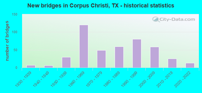
- New bridges - historical statistics
- 11920-1929
- 71930-1939
- 61940-1949
- 301950-1959
- 1201960-1969
- 491970-1979
- 591980-1989
- 801990-1999
- 582000-2009
- 252010-2019
- 132020-2022

- Reconstructed bridges - Historical Statistics
- 21940-1949
- 11950-1959
- 21960-1969
- 11970-1979
- 121980-1989
- 131990-1999
- 132000-2009
- 12010-2019


- Bridge Condition - Deck
- 1.5%Excellent
- 10.5%Very good
- 65.5%Good
- 22.0%Satisfactory
- 0.5%Fair

- Bridge Condition - Superstructure
- 1.0%Excellent
- 25.0%Very good
- 48.5%Good
- 22.0%Satisfactory
- 3.5%Fair

- Bridge Condition - Substructure
- 0.5%Excellent
- 5.0%Very good
- 55.0%Good
- 36.5%Satisfactory
- 1.5%Fair
- 1.5%Poor

- Bridge Condition - Channel
- 4.6%Very good
- 51.6%Good
- 35.9%Satisfactory
- 6.5%Fair
- 1.3%Poor

- Bridge Condition - Culverts
- 1.0%Very good
- 53.8%Good
- 41.3%Satisfactory
- 3.8%Fair
Find on map >> Show street view
Structure Number: 161780B03001001, Location: AT INTER OF NORTHGATE (Lat: 27.678714, Lng: -97.395583), Route carried "on" structure: City street , Year Built: 1983, Status: Open, Structure Length: 0.67m (2.20ft), Average Daily Traffic: 1,000 (year 2015), Average Future Daily Traffic: 1,500 (year 2035), Features Intersected: DRAINAGE DITCH, Facility Carried by Structure: EDINBURG CIRCLE
Minimum Vertical Clearance: 30+ m (98+ ft), Kilometerpoint: 0.016, Lanes on structure: 2, Owner: City or Municipal Highway Agency, Approaching Roadway Width: 11.0m (36.1ft), Material/Design: Concrete, Design/Construction: Culvert, Number Of Spans In Main Unit: 3, Length of Maximum Span: 1.8m (5.9ft), Curb or Sidewalk Widths: Left: 1.5m (4.9ft), Right: 1.5m (4.9ft)
Condition: Channel: Good, Culverts: Good, Operating Rating: 32.7 metric tons, Method Used To Determine Operating Rating: Field evaluation and documented engineering judgment, Inventory Rating: 24.5 metric tons, Method Used To Determine Inventory Rating: Field evaluation and documented engineering judgment, Structural Evaluation: Equal to present minimum criteria, Waterway Adequacy: Better than present minimum criteria, Approach Roadway Alignment: Equal to present desirable criteria, Designated Inspection Frequency: Every 24 months, Inspection Date: June 2021
Find on map >> Show street view
Structure Number: 161780B03010001, Location: AT HORSESHOE DR (Lat: 27.831664, Lng: -97.580344), Route carried "on" structure: City street , Year Built: 1985, Status: Open, Structure Length: 0.82m (2.69ft), Average Daily Traffic: 2,270 (year 2015), Truck Traffic: 2%, Average Future Daily Traffic: 2,500 (year 2035), Features Intersected: DRAINAGE DITCH, Facility Carried by Structure: WARRIOR DRIVE
Minimum Vertical Clearance: 30+ m (98+ ft), Kilometerpoint: 1.609, Lanes on structure: 2, Owner: City or Municipal Highway Agency, Approaching Roadway Width: 10.7m (35.1ft), Skew: 1 degrees, Material/Design: Concrete, Design/Construction: Culvert, Number Of Spans In Main Unit: 3, Length of Maximum Span: 2.4m (7.9ft), Curb or Sidewalk Widths: Left: 1.2m (3.9ft), Right: 1.2m (3.9ft)
Condition: Channel: Good, Culverts: Good, Operating Rating: 32.7 metric tons, Method Used To Determine Operating Rating: Field evaluation and documented engineering judgment, Inventory Rating: 24.5 metric tons, Method Used To Determine Inventory Rating: Field evaluation and documented engineering judgment, Structural Evaluation: Equal to present minimum criteria, Waterway Adequacy: Equal to present minimum criteria, Approach Roadway Alignment: Somewhat better than minimum adequacy, Designated Inspection Frequency: Every 24 months, Inspection Date: June 2021
Find on map >> Show street view
Structure Number: 161780B03015001, Location: AT WILDEROCK (Lat: 27.689611, Lng: -97.367011), Route carried "on" structure: City street , Year Built: 1985, Status: Open, Structure Length: 0.70m (2.30ft), Average Daily Traffic: 2,115 (year 2015), Average Future Daily Traffic: 3,000 (year 2035), Features Intersected: DRAINAGE DITCH, Facility Carried by Structure: CRICKET HOLLOW
Minimum Vertical Clearance: 30+ m (98+ ft), Kilometerpoint: 0.322, Lanes on structure: 2, Owner: City or Municipal Highway Agency, Approaching Roadway Width: 8.5m (27.9ft), Material/Design: Concrete, Design/Construction: Culvert, Number Of Spans In Main Unit: 2, Length of Maximum Span: 3.0m (9.8ft), Curb or Sidewalk Widths: Left: 1.7m (5.6ft), Right: 1.7m (5.6ft)
Condition: Channel: Good, Culverts: Good, Operating Rating: 32.7 metric tons, Method Used To Determine Operating Rating: Field evaluation and documented engineering judgment, Inventory Rating: 24.5 metric tons, Method Used To Determine Inventory Rating: Field evaluation and documented engineering judgment, Structural Evaluation: Equal to present minimum criteria, Waterway Adequacy: Equal to present minimum criteria, Approach Roadway Alignment: Equal to present desirable criteria, Designated Inspection Frequency: Every 24 months, Inspection Date: June 2021
Find on map >> Show street view
Structure Number: 161780B03030001, Location: 0.3 MI E OF AYERS ST (Lat: 27.726131, Lng: -97.426100), Route carried "on" structure: City street , Year Built: 1984, Status: Open, Structure Length: 0.98m (3.22ft), Average Daily Traffic: 2,850 (year 2015), Average Future Daily Traffic: 3,500 (year 2035), Features Intersected: DRAINAGE DITCH, Facility Carried by Structure: SERVICE CENTER RD
Minimum Vertical Clearance: 30+ m (98+ ft), Kilometerpoint: 0.483, Lanes on structure: 2, Owner: City or Municipal Highway Agency, Approaching Roadway Width: 7.9m (25.9ft), Material/Design: Concrete, Design/Construction: Culvert, Number Of Spans In Main Unit: 3, Length of Maximum Span: 3.0m (9.8ft), Curb-To-Curb Width: 17.6m (57.7ft), Out-to-Out Width: 18.3m (60.0ft)
Condition: Channel: Good, Culverts: Good, Operating Rating: 32.7 metric tons, Method Used To Determine Operating Rating: Field evaluation and documented engineering judgment, Inventory Rating: 24.5 metric tons, Method Used To Determine Inventory Rating: Field evaluation and documented engineering judgment, Structural Evaluation: Equal to present minimum criteria, Deck Geometry: Superior to present desirable criteria, Waterway Adequacy: Better than present minimum criteria, Approach Roadway Alignment: Equal to present desirable criteria, Designated Inspection Frequency: Every 24 months, Inspection Date: June 2021, Deck Structure Type: Concrete Cast-file-Place, Wearing Surface/Protective System: Wearing Surface: Bituminous
Find on map >> Show street view
Structure Number: 161780B03040001, Location: 0.01 MI S OF CEDAR PASS (Lat: 27.676483, Lng: -97.398958), Route carried "on" structure: City street , Year Built: 1994, Status: Open, Structure Length: 0.88m (2.89ft), Average Daily Traffic: 1,000 (year 2015), Average Future Daily Traffic: 2,000 (year 2035), Design Load: HS 20, Features Intersected: DRAINAGE DITCH, Facility Carried by Structure: SUN WOOD DR
Minimum Vertical Clearance: 30+ m (98+ ft), Kilometerpoint: 0.024, Lanes on structure: 2, Owner: City or Municipal Highway Agency, Approaching Roadway Width: 8.2m (26.9ft), Material/Design: Concrete, Design/Construction: Culvert, Number Of Spans In Main Unit: 3, Length of Maximum Span: 2.7m (8.9ft), Curb or Sidewalk Widths: Left: 2.9m (9.5ft), Right: 3.2m (10.5ft)
Condition: Channel: Good, Culverts: Good, Operating Rating: 39.9 metric tons, Method Used To Determine Operating Rating: Load Factor (LF), Inventory Rating: 23.6 metric tons, Method Used To Determine Inventory Rating: Load Factor (LF), Structural Evaluation: Equal to present minimum criteria, Waterway Adequacy: Better than present minimum criteria, Approach Roadway Alignment: Equal to present desirable criteria, Designated Inspection Frequency: Every 24 months, Inspection Date: June 2021
Find on map >> Show street view
Structure Number: 161780B04001001, Location: 0.32 MI S OF PR 22 (Lat: 27.663519, Lng: -97.285311), Route carried "on" structure: City street , Year Built: 1994, Status: Open, Structure Length: 0.67m (2.20ft), Average Daily Traffic: 8,000 (year 2015), Average Future Daily Traffic: 10,000 (year 2035), Features Intersected: DRAINAGE DITCH, Facility Carried by Structure: WALDRON RD
Minimum Vertical Clearance: 30+ m (98+ ft), Kilometerpoint: 0.515, Lanes on structure: 5, Owner: City or Municipal Highway Agency, Approaching Roadway Width: 18.3m (60.0ft), Material/Design: Concrete, Design/Construction: Culvert, Number Of Spans In Main Unit: 3, Length of Maximum Span: 1.8m (5.9ft), Curb or Sidewalk Widths: Left: 1.2m (3.9ft), Right: 1.2m (3.9ft)
Condition: Channel: Good, Culverts: Satisfactory, Operating Rating: 32.7 metric tons, Method Used To Determine Operating Rating: Field evaluation and documented engineering judgment, Inventory Rating: 24.5 metric tons, Method Used To Determine Inventory Rating: Field evaluation and documented engineering judgment, Structural Evaluation: Equal to present minimum criteria, Waterway Adequacy: Equal to present minimum criteria, Approach Roadway Alignment: Equal to present desirable criteria, Designated Inspection Frequency: Every 24 months, Inspection Date: June 2021
Find on map >> Show street view
Structure Number: 161780B70002001, Location: 0.2 MI S OF WHITECAP BLVD (Lat: 27.599456, Lng: -97.229406), Route carried "on" structure: City street , Year Built: 1973, Status: Open, Structure Length: 1.59m (5.22ft), Average Daily Traffic: 3,560 (year 2015), Average Future Daily Traffic: 5,000 (year 2035), Features Intersected: CANAL, Facility Carried by Structure: GYPSY
Minimum Vertical Clearance: 30+ m (98+ ft), Kilometerpoint: 0.241, Lanes on structure: 2, Owner: City or Municipal Highway Agency, Approaching Roadway Width: 11.9m (39.0ft), Material/Design: Prestressed concrete, Design/Construction: Box Beam or Girders - Multiple, Number Of Spans In Main Unit: 1, Length of Maximum Span: 15.5m (50.9ft), Curb or Sidewalk Widths: Left: 1.3m (4.3ft), Right: 0.0m, Curb-To-Curb Width: 8.7m (28.5ft), Out-to-Out Width: 10.4m (34.1ft)
Condition: Deck: Very good, Superstructure: Very good, Substructure: Satisfactory, Channel: Good, Operating Rating: 32.7 metric tons, Method Used To Determine Operating Rating: Field evaluation and documented engineering judgment, Inventory Rating: 24.5 metric tons, Method Used To Determine Inventory Rating: Field evaluation and documented engineering judgment, Structural Evaluation: Equal to present minimum criteria, Deck Geometry: Meets minimum limits, Waterway Adequacy: Better than present minimum criteria, Approach Roadway Alignment: Equal to present desirable criteria, Length Of Structure Improvement: 1.59m (5.22ft), Designated Inspection Frequency: Every 24 months, Inspection Date: June 2021, Bridge Improvement Cost: $94,000, Roadway Improvement Cost: $23,000, Total Project Cost: $117,000, Deck Structure Type: Concrete Precast Panels, Wearing Surface/Protective System: Wearing Surface: Bituminous
Find on map >> Show street view
Structure Number: 161780PC0100001, Location: 2.1 MI N OF MCKINZIE LN (Lat: 27.845500, Lng: -97.534500), Route carried "on" structure: City street , Year Built: 2010, Status: Open, Structure Length: 82.48m (270.60ft), Average Daily Traffic: 1,000 (year 2015), Truck Traffic: 10%, Average Future Daily Traffic: 1,300 (year 2035), Design Load: HS 20, Features Intersected: UP RR, Facility Carried by Structure: JOE FULTON I.T.C.
Minimum Vertical Clearance: 30+ m (98+ ft), Kilometerpoint: 0.161, Lanes on structure: 2, Owner: City or Municipal Highway Agency, Approaching Roadway Width: 13.4m (44.0ft), Skew: 9 degrees, Material/Design: Prestressed concrete, Design/Construction: Stringer/Multi-beam, Number Of Spans In Main Unit: 26, Number Of Approach Spans: 3, Length of Maximum Span: 35.4m (116.1ft), Curb-To-Curb Width: 13.3m (43.6ft), Out-to-Out Width: 14.0m (45.9ft)
Condition: Deck: Good, Superstructure: Good, Substructure: Good, Operating Rating: 54.4 metric tons, Method Used To Determine Operating Rating: Assigned rating based on Load Factor Design (LFD) reported in metric tons, Inventory Rating: 32.7 metric tons, Method Used To Determine Inventory Rating: Assigned rating based on Load Factor Design (LFD) reported in metric tons, Structural Evaluation: Better than present minimum criteria, Deck Geometry: Superior to present desirable criteria, Underclear: Superior to present desirable criteria, Approach Roadway Alignment: Equal to present minimum criteria, Designated Inspection Frequency: Every 24 months, Inspection Date: June 2021, Deck Structure Type: Concrete Precast Panels
Find on map >> Show street view
Structure Number: 161780PC0100002, Location: 0.5 MI N OF MCKINZIE LN. (Lat: 27.854139, Lng: -97.553333), Route carried "on" structure: City street , Year Built: 2010, Status: Open, Structure Length: 3.51m (11.52ft), Average Daily Traffic: 1,000 (year 2015), Truck Traffic: 10%, Average Future Daily Traffic: 1,200 (year 2035), Design Load: HS 20, Features Intersected: TURKEY CREEK, Facility Carried by Structure: JOE FULTON I.T.C.
Minimum Vertical Clearance: 30+ m (98+ ft), Kilometerpoint: 0.161, Lanes on structure: 2, Owner: City or Municipal Highway Agency, Approaching Roadway Width: 13.4m (44.0ft), Skew: 3 degrees, Material/Design: Concrete, Design/Construction: Culvert, Number Of Spans In Main Unit: 8, Length of Maximum Span: 3.0m (9.8ft), Curb-To-Curb Width: 13.4m (44.0ft), Out-to-Out Width: 34.7m (113.8ft)
Condition: Channel: Good, Culverts: Good, Operating Rating: 54.4 metric tons, Method Used To Determine Operating Rating: Assigned rating based on Load Factor Design (LFD) reported in metric tons, Inventory Rating: 32.7 metric tons, Method Used To Determine Inventory Rating: Assigned rating based on Load Factor Design (LFD) reported in metric tons, Structural Evaluation: Better than present minimum criteria, Deck Geometry: Superior to present desirable criteria, Waterway Adequacy: Better than present minimum criteria, Approach Roadway Alignment: Equal to present desirable criteria, Designated Inspection Frequency: Every 24 months, Inspection Date: June 2021, Deck Structure Type: Concrete Precast Panels, Wearing Surface/Protective System: Wearing Surface: Bituminous
Find on map >> Show street view
Structure Number: 162050007405048, Location: 0.3 MI S OF US 77 (Lat: 27.895694, Lng: -97.629256), Route carried "on" structure: Interstate 37, Year Built: 1958, Year Reconstructed: 1986, Status: Open, Structure Length: 84.98m (278.81ft), Average Daily Traffic: 21,050 (year 2013), Truck Traffic: 19%, Average Future Daily Traffic: 29,470 (year 2033), Design Load: H 20, Features Intersected: NUECES RIVER
Minimum Vertical Clearance: 30+ m (98+ ft), Kilometerpoint: 0.013, Lanes on structure: 3, Base Highway Network: Yes, Owner: State Highway Agency, Approaching Roadway Width: 17.1m (56.1ft), Material/Design: Steel continuous, Design/Construction: Stringer/Multi-beam, Number Of Spans In Main Unit: 3, Number Of Approach Spans: 81, Length of Maximum Span: 39.6m (129.9ft), Curb-To-Curb Width: 17.2m (56.4ft), Out-to-Out Width: 17.9m (58.7ft)
Condition: Deck: Satisfactory, Superstructure: Satisfactory, Substructure: Satisfactory, Channel: Satisfactory, Operating Rating: 48.1 metric tons, Method Used To Determine Operating Rating: Load Factor (LF), Inventory Rating: 29.0 metric tons, Method Used To Determine Inventory Rating: Load Factor (LF), Structural Evaluation: Equal to present minimum criteria, Deck Geometry: Better than present minimum criteria, Waterway Adequacy: Equal to present minimum criteria, Approach Roadway Alignment: Equal to present desirable criteria, Length Of Structure Improvement: 84.98m (278.81ft), Designated Inspection Frequency: Every 24 months, Inspection Date: April 2020, Bridge Improvement Cost: $3,123,000, Roadway Improvement Cost: $781,000, Total Project Cost: $3,904,000, Deck Structure Type: Concrete Cast-file-Place, Wearing Surface/Protective System: Wearing Surface: Bituminous
Find on map >> Show street view
Structure Number: 162050007405189, Location: 5.4 MI SE OF SH 234 (Lat: 27.903781, Lng: -97.631561), Route carried "on" structure: Interstate 37, Year Built: 1986, Year Reconstructed: 1997, Status: Open, Structure Length: 8.47m (27.79ft), Average Daily Traffic: 23,066 (year 2020), Truck Traffic: 20%, Average Future Daily Traffic: 18,460 (year 2033), Design Load: HS 20, Features Intersected: US 77 SB
Minimum Vertical Clearance: 30+ m (98+ ft), Kilometerpoint: 1.320, Lanes on structure: 3, Lanes under structure: 2, Owner: State Highway Agency, Approaching Roadway Width: 17.1m (56.1ft), Skew: 4 degrees, Material/Design: Prestressed concrete, Design/Construction: Stringer/Multi-beam, Number Of Spans In Main Unit: 3, Length of Maximum Span: 36.0m (118.1ft), Curb-To-Curb Width: 16.7m (54.8ft), Out-to-Out Width: 17.5m (57.4ft)
Condition: Deck: Satisfactory, Superstructure: Good, Substructure: Satisfactory, Operating Rating: 54.4 metric tons, Method Used To Determine Operating Rating: Assigned rating based on Load Factor Design (LFD) reported in metric tons, Inventory Rating: 32.7 metric tons, Method Used To Determine Inventory Rating: Assigned rating based on Load Factor Design (LFD) reported in metric tons, Structural Evaluation: Equal to present minimum criteria, Deck Geometry: Equal to present minimum criteria, Underclear: Superior to present desirable criteria, Approach Roadway Alignment: Equal to present desirable criteria, Designated Inspection Frequency: Every 24 months, Inspection Date: March 2020, Deck Structure Type: Concrete Cast-file-Place
Find on map >> Show street view
Structure Number: 162050007405199, Location: 0.3 MI S OF US 77 (Lat: 27.895717, Lng: -97.629178), Route carried "on" structure: Interstate 37, Year Built: 1933, Year Reconstructed: 1986, Status: Open, Structure Length: 84.89m (278.51ft), Average Daily Traffic: 21,050 (year 2013), Truck Traffic: 19%, Average Future Daily Traffic: 29,470 (year 2033), Features Intersected: NUECES RIVER
Minimum Vertical Clearance: 30+ m (98+ ft), Kilometerpoint: 0.013, Lanes on structure: 3, Base Highway Network: Yes, Owner: State Highway Agency, Approaching Roadway Width: 17.1m (56.1ft), Material/Design: Steel continuous, Design/Construction: Stringer/Multi-beam, Number Of Spans In Main Unit: 3, Number Of Approach Spans: 81, Length of Maximum Span: 39.6m (129.9ft), Curb-To-Curb Width: 17.2m (56.4ft), Out-to-Out Width: 17.9m (58.7ft)
Condition: Deck: Satisfactory, Superstructure: Satisfactory, Substructure: Satisfactory, Channel: Good, Operating Rating: 46.3 metric tons, Method Used To Determine Operating Rating: Load Factor (LF), Inventory Rating: 28.1 metric tons, Method Used To Determine Inventory Rating: Load Factor (LF), Structural Evaluation: Equal to present minimum criteria, Deck Geometry: Better than present minimum criteria, Waterway Adequacy: Equal to present minimum criteria, Approach Roadway Alignment: Equal to present desirable criteria, Length Of Structure Improvement: 84.89m (278.51ft), Designated Inspection Frequency: Every 24 months, Inspection Date: April 2020, Bridge Improvement Cost: $3,119,000, Roadway Improvement Cost: $780,000, Total Project Cost: $3,899,000, Deck Structure Type: Concrete Cast-file-Place, Wearing Surface/Protective System: Wearing Surface: Bituminous
Find on map >> Show street view
Structure Number: 162050037201005, Location: 1.0 MI NE OF IH 37 (Lat: 27.913319, Lng: -97.621461), Route carried "on" structure: US 77, Year Built: 1932, Year Reconstructed: 1952, Status: Open, Structure Length: 0.82m (2.69ft), Average Daily Traffic: 10,222 (year 2020), Truck Traffic: 27%, Average Future Daily Traffic: 12,870 (year 2033), Features Intersected: DRAW
Minimum Vertical Clearance: 30+ m (98+ ft), Kilometerpoint: 31.529, Lanes on structure: 2, Base Highway Network: Yes, Owner: State Highway Agency, Approaching Roadway Width: 11.6m (38.1ft), Material/Design: Concrete, Design/Construction: Culvert, Number Of Spans In Main Unit: 3, Length of Maximum Span: 2.4m (7.9ft), Curb-To-Curb Width: 13.1m (43.0ft), Out-to-Out Width: 13.8m (45.3ft)
Condition: Channel: Good, Culverts: Satisfactory, Operating Rating: 32.7 metric tons, Method Used To Determine Operating Rating: Field evaluation and documented engineering judgment, Inventory Rating: 24.5 metric tons, Method Used To Determine Inventory Rating: Field evaluation and documented engineering judgment, Structural Evaluation: Equal to present minimum criteria, Deck Geometry: Superior to present desirable criteria, Waterway Adequacy: Equal to present minimum criteria, Approach Roadway Alignment: Equal to present desirable criteria, Designated Inspection Frequency: Every 24 months, Inspection Date: January 2022, Deck Structure Type: Concrete Cast-file-Place, Wearing Surface/Protective System: Wearing Surface: Bituminous
Find on map >> Show street view
Structure Number: 16205003720101, Location: 1.00 MI NE OF IH 37 (Lat: 27.913375, Lng: -97.621550), Route carried "on" structure: US 77, Year Built: 1967, Status: Open, Structure Length: 0.76m (2.49ft), Average Daily Traffic: 9,409 (year 2020), Truck Traffic: 27%, Average Future Daily Traffic: 12,870 (year 2033), Design Load: HS 20, Features Intersected: DRAW
Minimum Vertical Clearance: 30+ m (98+ ft), Kilometerpoint: 31.529, Lanes on structure: 2, Base Highway Network: Yes, Owner: State Highway Agency, Approaching Roadway Width: 11.6m (38.1ft), Material/Design: Concrete, Design/Construction: Culvert, Number Of Spans In Main Unit: 3, Length of Maximum Span: 2.4m (7.9ft), Curb-To-Curb Width: 13.3m (43.6ft), Out-to-Out Width: 14.0m (45.9ft)
Condition: Channel: Good, Culverts: Good, Operating Rating: 39.9 metric tons, Method Used To Determine Operating Rating: Load Factor (LF), Inventory Rating: 23.6 metric tons, Method Used To Determine Inventory Rating: Load Factor (LF), Structural Evaluation: Somewhat better than minimum adequacy, Deck Geometry: Superior to present desirable criteria, Waterway Adequacy: Equal to present minimum criteria, Approach Roadway Alignment: Equal to present desirable criteria, Designated Inspection Frequency: Every 24 months, Inspection Date: January 2022, Deck Structure Type: Concrete Cast-file-Place, Wearing Surface/Protective System: Wearing Surface: Bituminous
Find on map >> Show street view
Structure Number: 162050120901001, Location: 2.45 MI S OF FM 2512 (Lat: 27.902758, Lng: -97.409342), Route carried "on" structure: State highway 893, Year Built: 1950, Year Reconstructed: 1963, Status: Open, Structure Length: 0.82m (2.69ft), Average Daily Traffic: 1,235 (year 2020), Truck Traffic: 10%, Average Future Daily Traffic: 980 (year 2033), Design Load: HS 20, Features Intersected: DRAINAGE DITCH
Minimum Vertical Clearance: 30+ m (98+ ft), Kilometerpoint: 7.361, Lanes on structure: 2, Owner: State Highway Agency, Approaching Roadway Width: 9.1m (29.9ft), Material/Design: Concrete, Design/Construction: Culvert, Number Of Spans In Main Unit: 4, Length of Maximum Span: 1.8m (5.9ft), Curb-To-Curb Width: 11.6m (38.1ft), Out-to-Out Width: 12.0m (39.4ft)
Condition: Channel: Very good, Culverts: Good, Operating Rating: 39.9 metric tons, Method Used To Determine Operating Rating: Load Factor (LF), Inventory Rating: 23.6 metric tons, Method Used To Determine Inventory Rating: Load Factor (LF), Structural Evaluation: Equal to present minimum criteria, Deck Geometry: Equal to present minimum criteria, Waterway Adequacy: Equal to present minimum criteria, Approach Roadway Alignment: Equal to present desirable criteria, Designated Inspection Frequency: Every 24 months, Inspection Date: April 2020, Deck Structure Type: Concrete Cast-file-Place, Wearing Surface/Protective System: Wearing Surface: Bituminous
Find on map >> Show street view
Structure Number: 162050AA0391001, Location: 0.90 MI W OF CR 3161 (Lat: 27.881569, Lng: -97.441519), Route carried "on" structure: County highway 2200, Year Built: 2005, Status: Open, Structure Length: 0.85m (2.79ft), Average Daily Traffic: 75 (year 2011), Average Future Daily Traffic: 100 (year 2031), Design Load: HL 93, Features Intersected: DRAW
Minimum Vertical Clearance: 30+ m (98+ ft), Kilometerpoint: 0.161, Lanes on structure: 2, Owner: County Highway Agency, Approaching Roadway Width: 3.7m (12.1ft), Material/Design: Concrete, Design/Construction: Culvert, Number Of Spans In Main Unit: 3, Length of Maximum Span: 2.4m (7.9ft), Curb-To-Curb Width: 7.2m (23.6ft), Out-to-Out Width: 7.9m (25.9ft)
Condition: Channel: Satisfactory, Culverts: Good, Operating Rating: 54.4 metric tons, Method Used To Determine Operating Rating: Assigned ratings based on Load and Resistance Factor Design (LRFD) reported in metric tons, Inventory Rating: 32.7 metric tons, Method Used To Determine Inventory Rating: Assigned ratings based on Load and Resistance Factor Design (LRFD) reported in metric tons, Structural Evaluation: Better than present minimum criteria, Deck Geometry: Somewhat better than minimum adequacy, Waterway Adequacy: Superior to present desirable criteria, Approach Roadway Alignment: Equal to present desirable criteria, Designated Inspection Frequency: Every 24 months, Inspection Date: June 2021, Deck Structure Type: Concrete Cast-file-Place, Wearing Surface/Protective System: Wearing Surface: Bituminous
Find on map >> Show street view
Structure Number: 161780007406007, Location: US 77 AT IH 37 (Lat: 27.863347, Lng: -97.620733), Route carried "under" structure: Interstate 37, Year Built: 2007, Structure Length: 0. m, Average Daily Traffic: 45,560 (year 2013), Truck Traffic: 11%, Features Intersected: IH 37, Facility Carried by Structure: US 77 SB CONN
Minimum Vertical Clearance: 5.61m (18.41ft), Kilometerpoint: 23.670, Lanes on structure: 1, Lanes under structure: 8, Material/Design: Prestressed concrete, Design/Construction: Stringer/Multi-beam, Length of Maximum Span: 36.6m (120.1ft)
Find on map >> Show street view
Structure Number: 161780007406049, Location: 0.10 MI N OF IH 37 (Lat: 27.802114, Lng: -97.396683), Route carried "under" structure: City street , Year Built: 1959, Structure Length: 0. m, Average Daily Traffic: 300 (year 2013), Features Intersected: BELDEN ST, Facility Carried by Structure: US 181 NB
Minimum Vertical Clearance: 4.65m (15.26ft), Kilometerpoint: 0.161, Lanes on structure: 4, Lanes under structure: 2, Material/Design: Prestressed concrete, Design/Construction: Stringer/Multi-beam, Length of Maximum Span: 18.3m (60.0ft)
Find on map >> Show street view
Structure Number: 16178000740605, Location: 0.10 MI N OF IH 37 (Lat: 27.802128, Lng: -97.396878), Route carried "under" structure: City street , Year Built: 1959, Structure Length: 0. m, Average Daily Traffic: 300 (year 2013), Features Intersected: BELDEN ST, Facility Carried by Structure: US 181 SB
Minimum Vertical Clearance: 4.44m (14.57ft), Kilometerpoint: 0.161, Lanes on structure: 3, Lanes under structure: 2, Material/Design: Prestressed concrete, Design/Construction: Stringer/Multi-beam, Length of Maximum Span: 18.3m (60.0ft)
Find on map >> Show street view
Structure Number: 161780007406061, Location: @ IH 37 & SH 286 I/C (Lat: 27.797761, Lng: -97.409672), Route carried "under" structure: Ramp State highway 286, Year Built: 1963, Structure Length: 0. m, Average Daily Traffic: 6,443 (year 2008), Truck Traffic: 4%, Features Intersected: SH 286 NB CONN, Facility Carried by Structure: IH 37 SB
Minimum Vertical Clearance: 5.18m (16.99ft), Kilometerpoint: 0.032, Lanes on structure: 2, Lanes under structure: 1, Material/Design: Prestressed concrete, Design/Construction: Stringer/Multi-beam, Length of Maximum Span: 27.4m (89.9ft)
Find on map >> Show street view
Structure Number: 161780007406064, Location: 0.80 MI W OF US 181 (Lat: 27.798236, Lng: -97.408506), Route carried "under" structure: City street , Year Built: 1963, Structure Length: 0. m, Average Daily Traffic: 1,000 (year 2008), Features Intersected: N BROWNLEE ST, Facility Carried by Structure: IH 37 SB
Minimum Vertical Clearance: 4.70m (15.42ft), Kilometerpoint: 0.161, Lanes on structure: 2, Lanes under structure: 4, Material/Design: Prestressed concrete, Design/Construction: Stringer/Multi-beam, Length of Maximum Span: 15.2m (49.9ft)
Find on map >> Show street view
Structure Number: 161780007406065, Location: 0.80 MI W OF US 181 (Lat: 27.798303, Lng: -97.408492), Route carried "under" structure: City street , Year Built: 1963, Structure Length: 0. m, Average Daily Traffic: 1,000 (year 2008), Features Intersected: N BROWNLEE ST, Facility Carried by Structure: IH 37 NB
Minimum Vertical Clearance: 4.47m (14.67ft), Kilometerpoint: 0.161, Lanes on structure: 2, Lanes under structure: 4, Material/Design: Prestressed concrete, Design/Construction: Stringer/Multi-beam, Length of Maximum Span: 15.2m (49.9ft)
Find on map >> Show street view
Structure Number: 161780007406069, Location: 1.40 MI W OF SH 286 (Lat: 27.802367, Lng: -97.430856), Route carried "under" structure: City street , Year Built: 1964, Structure Length: 0. m, Average Daily Traffic: 2,000 (year 2008), Features Intersected: BUDDY LAWRENCE DR, Facility Carried by Structure: IH 37 SB
Minimum Vertical Clearance: 4.75m (15.58ft), Kilometerpoint: 0.161, Lanes on structure: 3, Lanes under structure: 4, Material/Design: Prestressed concrete, Design/Construction: Stringer/Multi-beam, Length of Maximum Span: 15.2m (49.9ft)
Find on map >> Show street view
Structure Number: 16178000740607, Location: 1.40 MI W OF SH 286 (Lat: 27.802478, Lng: -97.430864), Route carried "under" structure: City street , Year Built: 1964, Structure Length: 0. m, Average Daily Traffic: 2,000 (year 2008), Features Intersected: BUDDY LAWRENCE DR, Facility Carried by Structure: IH 37 NB
Minimum Vertical Clearance: 4.88m (16.01ft), Kilometerpoint: 0.161, Lanes on structure: 2, Lanes under structure: 4, Material/Design: Prestressed concrete, Design/Construction: Stringer/Multi-beam, Length of Maximum Span: 15.2m (49.9ft)
Find on map >> Show street view
Structure Number: 161780007406074, Location: 2.70 MI W OF SH 286 (Lat: 27.803781, Lng: -97.453392), Route carried "under" structure: City street , Year Built: 1965, Structure Length: 0. m, Average Daily Traffic: 3,000 (year 2011), Truck Traffic: 15%, Features Intersected: NAVIGATION BLVD, Facility Carried by Structure: IH 37 SB
Minimum Vertical Clearance: 5.13m (16.83ft), Kilometerpoint: 0.002, Lanes on structure: 3, Lanes under structure: 6, Material/Design: Prestressed concrete, Design/Construction: Stringer/Multi-beam, Length of Maximum Span: 16.8m (55.1ft)
Find on map >> Show street view
Structure Number: 161780007406075, Location: 2.70 MI W OF SH 286 (Lat: 27.803892, Lng: -97.453386), Route carried "under" structure: City street , Year Built: 1965, Structure Length: 0. m, Average Daily Traffic: 3,000 (year 2011), Truck Traffic: 15%, Features Intersected: NAVIGATION BLVD, Facility Carried by Structure: IH 37 NB
Minimum Vertical Clearance: 5.13m (16.83ft), Kilometerpoint: 0.002, Lanes on structure: 3, Lanes under structure: 6, Material/Design: Prestressed concrete, Design/Construction: Stringer/Multi-beam, Length of Maximum Span: 16.8m (55.1ft)
Find on map >> Show street view
Structure Number: 161780007406077, Location: 2.15 MI W OF SH 286 (Lat: 27.802750, Lng: -97.442886), Route carried "under" structure: City street , Year Built: 1965, Structure Length: 0. m, Average Daily Traffic: 2,000 (year 2008), Truck Traffic: 10%, Features Intersected: UP RIVER RD, Facility Carried by Structure: IH 37 SB
Minimum Vertical Clearance: 5.08m (16.67ft), Kilometerpoint: 0.161, Lanes on structure: 3, Lanes under structure: 6, Material/Design: Prestressed concrete, Design/Construction: Stringer/Multi-beam, Length of Maximum Span: 22.9m (75.1ft)
Find on map >> Show street view
Structure Number: 161780007406078, Location: 2.10 MI W OF SH 286 (Lat: 27.802844, Lng: -97.442894), Route carried "under" structure: City street , Year Built: 1965, Structure Length: 0. m, Average Daily Traffic: 2,000 (year 2008), Truck Traffic: 10%, Features Intersected: UP RIVER RD, Facility Carried by Structure: IH 37 NB
Minimum Vertical Clearance: 4.95m (16.24ft), Kilometerpoint: 0.161, Lanes on structure: 3, Lanes under structure: 6, Material/Design: Prestressed concrete, Design/Construction: Stringer/Multi-beam, Length of Maximum Span: 22.9m (75.1ft)
Find on map >> Show street view
Structure Number: 161780007406079, Location: 1.0 MI W OF SH 358 (Lat: 27.805092, Lng: -97.484414), Route carried "under" structure: Interstate 37, Year Built: 1966, Structure Length: 0. m, Average Daily Traffic: 55,620 (year 2013), Truck Traffic: 11%, Features Intersected: IH 37, Facility Carried by Structure: CORN PRODUCTS RD
Minimum Vertical Clearance: 5.31m (17.42ft), Kilometerpoint: 8.359, Lanes on structure: 2, Lanes under structure: 6, Material/Design: Prestressed concrete, Design/Construction: Stringer/Multi-beam, Length of Maximum Span: 21.3m (69.9ft)
Find on map >> Show street view
Structure Number: 16178000740608, Location: 0.05 MI W OF SH 358 (Lat: 27.803961, Lng: -97.470203), Route carried "under" structure: City street , Year Built: 1966, Structure Length: 0. m, Average Daily Traffic: 1,500 (year 2008), Truck Traffic: 2%, Features Intersected: LANTANA ST, Facility Carried by Structure: IH 37 SB
Minimum Vertical Clearance: 4.62m (15.16ft), Kilometerpoint: 0.161, Lanes on structure: 3, Lanes under structure: 4, Material/Design: Prestressed concrete, Design/Construction: Stringer/Multi-beam, Length of Maximum Span: 21.9m (71.9ft)
Find on map >> Show street view
Structure Number: 161780007406081, Location: 0.05 MI W OF SH 358 (Lat: 27.804408, Lng: -97.470217), Route carried "under" structure: City street , Year Built: 1966, Structure Length: 0. m, Average Daily Traffic: 1,500 (year 2008), Truck Traffic: 2%, Features Intersected: LANTANA ST, Facility Carried by Structure: IH 37 NB
Minimum Vertical Clearance: 4.40m (14.44ft), Kilometerpoint: 0.161, Lanes on structure: 2, Lanes under structure: 4, Material/Design: Prestressed concrete, Design/Construction: Stringer/Multi-beam, Length of Maximum Span: 21.9m (71.9ft)
Find on map >> Show street view
Structure Number: 161780007406082, Location: 3.65 MI W OF SH 286 (Lat: 27.803419, Lng: -97.467883), Route carried "under" structure: Interstate 37, Year Built: 1966, Structure Length: 0. m, Average Daily Traffic: 20,180 (year 2013), Truck Traffic: 11%, Features Intersected: IH 37 SB, Facility Carried by Structure: SH 358 WB CONN
Minimum Vertical Clearance: 5.92m (19.42ft), Kilometerpoint: 6.682, Lanes on structure: 2, Lanes under structure: 4, Material/Design: Prestressed concrete, Design/Construction: Stringer/Multi-beam, Length of Maximum Span: 27.7m (90.9ft)
Find on map >> Show street view
Structure Number: 161780007406083, Location: 3.55 MI W OF SH 286 (Lat: 27.803819, Lng: -97.466897), Route carried "under" structure: Interstate 37, Year Built: 1966, Structure Length: 0. m, Average Daily Traffic: 20,180 (year 2013), Truck Traffic: 11%, Features Intersected: IH 37 SB
Minimum Vertical Clearance: 5.26m (17.26ft), Kilometerpoint: 6.558, Lanes on structure: 2, Lanes under structure: 2, Material/Design: Prestressed concrete, Design/Construction: Stringer/Multi-beam, Length of Maximum Span: 32.0m (105.0ft)
Find on map >> Show street view
Structure Number: 161780007406084, Location: 3.25 MI W OF SH 286 (Lat: 27.804250, Lng: -97.462164), Route carried "under" structure: Interstate 37, Year Built: 1966, Structure Length: 0. m, Average Daily Traffic: 40,360 (year 2013), Truck Traffic: 11%, Features Intersected: IH 37, Facility Carried by Structure: MCBRIDE LANE
Minimum Vertical Clearance: 5.16m (16.93ft), Kilometerpoint: 6.156, Lanes on structure: 2, Lanes under structure: 6, Material/Design: Prestressed concrete, Design/Construction: Stringer/Multi-beam, Length of Maximum Span: 21.3m (69.9ft)
Find on map >> Show street view
Structure Number: 161780007406089, Location: 4.50 MI W OF SH 358 (Lat: 27.827722, Lng: -97.536058), Route carried "under" structure: Interstate 37, Year Built: 1968, Structure Length: 0. m, Average Daily Traffic: 53,300 (year 2013), Truck Traffic: 11%, Features Intersected: IH 37, Facility Carried by Structure: CLARKWOOD RD
Minimum Vertical Clearance: 5.08m (16.67ft), Kilometerpoint: 14.180, Lanes on structure: 2, Lanes under structure: 10, Material/Design: Prestressed concrete, Design/Construction: Stringer/Multi-beam, Length of Maximum Span: 25.0m (82.0ft)
Find on map >> Show street view
Structure Number: 16178000740609, Location: 3.70 MI W OF SH 358 (Lat: 27.822944, Lng: -97.523933), Route carried "under" structure: City street , Year Built: 1968, Structure Length: 0. m, Average Daily Traffic: 1,500 (year 2010), Features Intersected: TULOSO RD, Facility Carried by Structure: IH 37
Minimum Vertical Clearance: 4.70m (15.42ft), Kilometerpoint: 0.161, Lanes on structure: 6, Lanes under structure: 2, Material/Design: Prestressed concrete, Design/Construction: Stringer/Multi-beam, Length of Maximum Span: 21.3m (69.9ft)
Find on map >> Show street view
Structure Number: 161780007406092, Location: 3.45 MI W OF SH 358 (Lat: 27.821483, Lng: -97.520161), Route carried "under" structure: Interstate 37, Year Built: 1968, Structure Length: 0. m, Average Daily Traffic: 53,300 (year 2013), Truck Traffic: 11%, Features Intersected: IH 37, Facility Carried by Structure: SUNTIDE RD
Minimum Vertical Clearance: 5.61m (18.41ft), Kilometerpoint: 12.474, Lanes on structure: 2, Lanes under structure: 6, Material/Design: Prestressed concrete, Design/Construction: Stringer/Multi-beam, Length of Maximum Span: 22.3m (73.2ft)
Find on map >> Show street view
Structure Number: 161780007406093, Location: 2.15 MI W OF SH 358 (Lat: 27.811142, Lng: -97.502556), Route carried "under" structure: Interstate 37, Year Built: 1968, Structure Length: 0. m, Average Daily Traffic: 55,620 (year 2013), Truck Traffic: 11%, Features Intersected: IH 37, Facility Carried by Structure: SOUTHERN MINERALS
Minimum Vertical Clearance: 5.21m (17.09ft), Kilometerpoint: 10.280, Lanes on structure: 2, Lanes under structure: 10, Material/Design: Prestressed concrete, Design/Construction: Stringer/Multi-beam, Length of Maximum Span: 23.8m (78.1ft)
Find on map >> Show street view
Structure Number: 161780007406096, Location: 1.30 MI W OF FM 24 (Lat: 27.856897, Lng: -97.601794), Route carried "under" structure: Interstate 37, Year Built: 1968, Structure Length: 0. m, Average Daily Traffic: 45,370 (year 2013), Truck Traffic: 11%, Features Intersected: IH 37, Facility Carried by Structure: CALLICOATE RD
Minimum Vertical Clearance: 5.36m (17.59ft), Kilometerpoint: 21.581, Lanes on structure: 2, Lanes under structure: 6, Material/Design: Prestressed concrete, Design/Construction: Stringer/Multi-beam, Length of Maximum Span: 22.3m (73.2ft)
Find on map >> Show street view
Structure Number: 161780007406097, Location: 0.65 MI W OF FM 24 (Lat: 27.853517, Lng: -97.591822), Route carried "under" structure: City street , Year Built: 1968, Structure Length: 0. m, Average Daily Traffic: 300 (year 2010), Features Intersected: HART RD, Facility Carried by Structure: IH 37
Minimum Vertical Clearance: 4.44m (14.57ft), Kilometerpoint: 0.161, Lanes on structure: 6, Lanes under structure: 2, Material/Design: Prestressed concrete, Design/Construction: Stringer/Multi-beam, Length of Maximum Span: 21.3m (69.9ft)
Find on map >> Show street view
Structure Number: 161780007406099, Location: 0.65 MI W OF FM 3386 (Lat: 27.850050, Lng: -97.581997), Route carried "under" structure: Interstate 37, Year Built: 1968, Structure Length: 0. m, Average Daily Traffic: 45,370 (year 2013), Truck Traffic: 11%, Features Intersected: IH 37, Facility Carried by Structure: FM 24 - VIOLET RD
Minimum Vertical Clearance: 5.41m (17.75ft), Kilometerpoint: 19.481, Lanes on structure: 2, Lanes under structure: 6, Material/Design: Prestressed concrete, Design/Construction: Stringer/Multi-beam, Length of Maximum Span: 22.9m (75.1ft)
Find on map >> Show street view
Structure Number: 1617800074061, Location: 0.65 MI E OF FM 24 (Lat: 27.846714, Lng: -97.572178), Route carried "under" structure: City street , Year Built: 1968, Structure Length: 0. m, Average Daily Traffic: 5,000 (year 2010), Features Intersected: MC KINZIE RD, Facility Carried by Structure: IH 37
Minimum Vertical Clearance: 5.13m (16.83ft), Kilometerpoint: 0.161, Lanes on structure: 7, Lanes under structure: 6, Material/Design: Prestressed concrete, Design/Construction: Stringer/Multi-beam, Length of Maximum Span: 27.4m (89.9ft)
Find on map >> Show street view
Structure Number: 161780007406102, Location: 0.70 MI E OF FM 3386 (Lat: 27.842586, Lng: -97.561475), Route carried "under" structure: Interstate 37, Year Built: 1968, Structure Length: 0. m, Average Daily Traffic: 53,300 (year 2013), Truck Traffic: 11%, Features Intersected: IH 37, Facility Carried by Structure: CARBON PLANT RD
Minimum Vertical Clearance: 5.16m (16.93ft), Kilometerpoint: 17.307, Lanes on structure: 2, Lanes under structure: 6, Material/Design: Prestressed concrete, Design/Construction: Stringer/Multi-beam, Length of Maximum Span: 23.8m (78.1ft)
Find on map >> Show street view
Structure Number: 161780007406106, Location: 5.35 MI W OF SH 358 (Lat: 27.834494, Lng: -97.547511), Route carried "under" structure: City street , Year Built: 1968, Structure Length: 0. m, Average Daily Traffic: 2,000 (year 2010), Features Intersected: RAND MORGAN RD, Facility Carried by Structure: IH 37
Minimum Vertical Clearance: 4.72m (15.49ft), Kilometerpoint: 0.161, Lanes on structure: 6, Lanes under structure: 4, Material/Design: Prestressed concrete, Design/Construction: Stringer/Multi-beam, Length of Maximum Span: 30.5m (100.1ft)
Find on map >> Show street view
Structure Number: 161780007406169, Location: 0.35 MI W OF SHORELINE (Lat: 27.800208, Lng: -97.396258), Route carried "under" structure: State highway 44, Year Built: 1959, Structure Length: 0. m, Average Daily Traffic: 17,200 (year 2012), Truck Traffic: 6%, Features Intersected: BU 44 D, Facility Carried by Structure: US 181 NB ON-RP
Minimum Vertical Clearance: 8.05m (26.41ft), Kilometerpoint: 40.765, Lanes on structure: 1, Lanes under structure: 5, Material/Design: Prestressed concrete, Design/Construction: Stringer/Multi-beam, Length of Maximum Span: 21.3m (69.9ft)
Find on map >> Show street view
Structure Number: 16178000740617, Location: 0.35 MI W OF SHORELINE (Lat: 27.800250, Lng: -97.396653), Route carried "under" structure: State highway 44, Year Built: 1959, Structure Length: 0. m, Average Daily Traffic: 17,200 (year 2012), Truck Traffic: 6%, Features Intersected: BU 44 D, Facility Carried by Structure: US 181 NB
Minimum Vertical Clearance: 7.93m (26.02ft), Kilometerpoint: 40.765, Lanes on structure: 2, Lanes under structure: 5, Material/Design: Prestressed concrete, Design/Construction: Stringer/Multi-beam, Length of Maximum Span: 21.3m (69.9ft)
Find on map >> Show street view
Structure Number: 161780007406171, Location: 0.35 MI W OF SHORELINE (Lat: 27.800286, Lng: -97.396819), Route carried "under" structure: State highway 44, Year Built: 1959, Structure Length: 0. m, Average Daily Traffic: 17,200 (year 2012), Truck Traffic: 6%, Features Intersected: BU 44 D, Facility Carried by Structure: US 181 SB OFF-RP
Minimum Vertical Clearance: 4.72m (15.49ft), Kilometerpoint: 40.834, Lanes on structure: 2, Lanes under structure: 3, Material/Design: Prestressed concrete, Design/Construction: Stringer/Multi-beam, Length of Maximum Span: 18.3m (60.0ft)
Find on map >> Show street view
Structure Number: 161780007406172, Location: 0.10 MI W OF US 181 (Lat: 27.799656, Lng: -97.398172), Route carried "under" structure: US 181, Year Built: 1959, Structure Length: 0. m, Average Daily Traffic: 52,900 (year 2013), Truck Traffic: 7%, Features Intersected: IH 37, Facility Carried by Structure: CARANCAHUA ST
Minimum Vertical Clearance: 7.39m (24.25ft), Kilometerpoint: 32.790, Lanes on structure: 2, Lanes under structure: 7, Material/Design: Prestressed concrete, Design/Construction: Stringer/Multi-beam, Length of Maximum Span: 21.3m (69.9ft)
Find on map >> Show street view
Structure Number: 161780007406173, Location: 0.15 MI W OF US 181 (Lat: 27.799333, Lng: -97.398878), Route carried "under" structure: US 181, Year Built: 1959, Structure Length: 0. m, Average Daily Traffic: 52,900 (year 2013), Truck Traffic: 7%, Features Intersected: IH 37, Facility Carried by Structure: TANCAHUA ST
Minimum Vertical Clearance: 5.33m (17.49ft), Kilometerpoint: 33.012, Lanes on structure: 2, Lanes under structure: 8, Material/Design: Prestressed concrete, Design/Construction: Stringer/Multi-beam, Length of Maximum Span: 21.3m (69.9ft)
Find on map >> Show street view
Structure Number: 161780007406191, Location: 1.00 MI W OF FM 1694 (Lat: 27.861561, Lng: -97.617239), Route carried "under" structure: Interstate 37, Year Built: 1991, Structure Length: 0. m, Average Daily Traffic: 45,560 (year 2013), Truck Traffic: 11%, Features Intersected: IH 37
Minimum Vertical Clearance: 6.20m (20.34ft), Kilometerpoint: 23.204, Lanes on structure: 2, Lanes under structure: 7, Material/Design: Prestressed concrete, Design/Construction: Stringer/Multi-beam, Length of Maximum Span: 25.9m (85.0ft)
Find on map >> Show street view
Structure Number: 161780007406192, Location: 0.6 MI NE OF FM 624 (Lat: 27.863581, Lng: -97.621006), Route carried "under" structure: Interstate 37, Year Built: 1991, Structure Length: 0. m, Average Daily Traffic: 52,830 (year 2010), Truck Traffic: 17%, Features Intersected: IH 37
Minimum Vertical Clearance: 6.22m (20.41ft), Kilometerpoint: 23.474, Lanes on structure: 1, Lanes under structure: 8, Material/Design: Prestressed concrete, Design/Construction: Stringer/Multi-beam, Length of Maximum Span: 38.1m (125.0ft)
Find on map >> Show street view
Structure Number: 161780007406193, Location: 0.85 MI NE OF FM 624 (Lat: 27.863361, Lng: -97.622561), Route carried "under" structure: US 77, Year Built: 1991, Structure Length: 0. m, Average Daily Traffic: 4,500 (year 2010), Truck Traffic: 5%, Features Intersected: IH 37
Minimum Vertical Clearance: 30+ m (98+ ft), Kilometerpoint: 23.480, Lanes on structure: 2, Lanes under structure: 9, Material/Design: Prestressed concrete, Design/Construction: Stringer/Multi-beam, Length of Maximum Span: 33.5m (109.9ft)
Find on map >> Show street view
Structure Number: 161780007406194, Location: 2.0 MI S OF SAN PAT C/L (Lat: 27.867331, Lng: -97.623028), Route carried "under" structure: Interstate 37, Year Built: 1991, Structure Length: 0. m, Average Daily Traffic: 42,100 (year 2013), Truck Traffic: 19%, Features Intersected: IH 37 & US 77, Facility Carried by Structure: REDBIRD LANE
Minimum Vertical Clearance: 6.38m (20.93ft), Kilometerpoint: 24.114, Lanes on structure: 3, Lanes under structure: 10, Material/Design: Prestressed concrete, Design/Construction: Stringer/Multi-beam, Length of Maximum Span: 39.0m (128.0ft)
Find on map >> Show street view
Structure Number: 161780007406195, Location: 1.5 MI S OF SAN PAT C/L (Lat: 27.871533, Lng: -97.623225), Route carried "under" structure: City street , Year Built: 1991, Structure Length: 0. m, Average Daily Traffic: 500 (year 2011), Features Intersected: SHARPSBURG RD, Facility Carried by Structure: IH 37 NB
Minimum Vertical Clearance: 5.97m (19.59ft), Kilometerpoint: 0.161, Lanes on structure: 3, Lanes under structure: 4, Material/Design: Prestressed concrete, Design/Construction: Stringer/Multi-beam, Length of Maximum Span: 27.4m (89.9ft)
Find on map >> Show street view
Structure Number: 161780007406196, Location: 0.85 MI NE OF FM 624 (Lat: 27.865531, Lng: -97.623333), Route carried "under" structure: US 77, Year Built: 1991, Structure Length: 0. m, Average Daily Traffic: 11,410 (year 2010), Truck Traffic: 35%, Features Intersected: US 77 SB, Facility Carried by Structure: IH 37 SB ON RAMP
Minimum Vertical Clearance: 5.18m (16.99ft), Kilometerpoint: 0.092, Lanes on structure: 1, Lanes under structure: 2, Material/Design: Prestressed concrete, Design/Construction: Stringer/Multi-beam, Length of Maximum Span: 26.8m (87.9ft)
Find on map >> Show street view
Structure Number: 161780007406197, Location: 1.5 MI S OF SAN PAT C/L (Lat: 27.874400, Lng: -97.623600), Route carried "under" structure: City street , Year Built: 1991, Structure Length: 0. m, Average Daily Traffic: 500 (year 2011), Features Intersected: SHARPSBURG RD, Facility Carried by Structure: IH 37 SB
Minimum Vertical Clearance: 5.44m (17.85ft), Kilometerpoint: 0.161, Lanes on structure: 3, Lanes under structure: 4, Material/Design: Prestressed concrete, Design/Construction: Stringer/Multi-beam, Length of Maximum Span: 27.4m (89.9ft)
Find on map >> Show street view
Structure Number: 161780007406203, Location: IH 37 at CARBON PLANT RD (Lat: 27.843356, Lng: -97.563469), Route carried "under" structure: Interstate 37, Year Built: 2011, Structure Length: 0. m, Average Daily Traffic: 53,300 (year 2013), Truck Traffic: 11%, Features Intersected: IH 37, Facility Carried by Structure: CARBON PLANT CON
Minimum Vertical Clearance: 9.50m (31.17ft), Kilometerpoint: 17.461, Lanes on structure: 1, Lanes under structure: 21, Material/Design: Steel continuous, Design/Construction: Stringer/Multi-beam, Length of Maximum Span: 80.8m (265.1ft)
Find on map >> Show street view
Structure Number: 161780007406205, Location: 0.40 MI W OF US 181 (Lat: 27.797878, Lng: -97.402939), Route carried "under" structure: Interstate 37, Year Built: 2020, Structure Length: 0. m, Features Intersected: IH 37, Facility Carried by Structure: N STAPLES ST
Minimum Vertical Clearance: 5.03m (16.50ft), Lanes on structure: 4, Lanes under structure: 8, Material/Design: Prestressed concrete, Design/Construction: Stringer/Multi-beam, Length of Maximum Span: 21.3m (69.9ft)
Find on map >> Show street view
Structure Number: 161780007406206, Location: at Nueces Bay Blvd (Lat: 27.800925, Lng: -97.424392), Route carried "under" structure: City street , Year Built: 2020, Structure Length: 0. m, Average Daily Traffic: 4,878 (year 2019), Truck Traffic: 11%, Features Intersected: Nueces Bay Blvd, Facility Carried by Structure: IH 37 SBML
Minimum Vertical Clearance: 5.01m (16.44ft), Kilometerpoint: 24.752, Lanes on structure: 4, Lanes under structure: 2, Material/Design: Prestressed concrete, Design/Construction: Stringer/Multi-beam, Length of Maximum Span: 24.7m (81.0ft)
Find on map >> Show street view
Structure Number: 161780007406213, Location: 0.25 MI W OF SH 286 (Lat: 27.798136, Lng: -97.413747), Route carried "under" structure: City street , Year Built: 2020, Structure Length: 0. m, Average Daily Traffic: 2,000 (year 2008), Features Intersected: Port Ave., Facility Carried by Structure: IH 37
Minimum Vertical Clearance: 5.03m (16.50ft), Kilometerpoint: 0.161, Lanes on structure: 6, Lanes under structure: 7, Material/Design: Prestressed concrete, Design/Construction: Stringer/Multi-beam, Length of Maximum Span: 42.7m (140.1ft)
Find on map >> Show street view
Structure Number: 161780007406216, Location: 1.0 MI W OF SH 286 (Lat: 27.801031, Lng: -97.424019), Route carried "under" structure: City street , Year Built: 2021, Structure Length: 0. m, Average Daily Traffic: 4,878 (year 2019), Truck Traffic: 11%, Features Intersected: NUECES BLVD RD, Facility Carried by Structure: IH 37 NBML
Minimum Vertical Clearance: 5.12m (16.80ft), Kilometerpoint: 10.058, Lanes on structure: 3, Lanes under structure: 6, Material/Design: Prestressed concrete, Design/Construction: Stringer/Multi-beam, Length of Maximum Span: 24.7m (81.0ft)
Find on map >> Show street view
Structure Number: 161780007409057, Location: 0.75 MI E OF SH 358 (Lat: 27.797358, Lng: -97.455706), Route carried "under" structure: ServiceState highway 407, Year Built: 1956, Structure Length: 0. m, Average Daily Traffic: 500 (year 2012), Truck Traffic: 5%, Features Intersected: TEX-MEX RR
Minimum Vertical Clearance: 4.55m (14.93ft), Kilometerpoint: 18.495, Lanes on structure: 4, Lanes under structure: 4, Material/Design: Prestressed concrete, Design/Construction: Stringer/Multi-beam, Length of Maximum Span: 16.8m (55.1ft)
Structure Number: 161780010106041, Location: 3.16 M SW OF NUECES CO LN, Route carried "under" structure: City street , Year Built: 1959, Structure Length: 0. m, Average Daily Traffic: 1,000 (year 2012), Truck Traffic: 5%, Features Intersected: C C SHIP CHANNEL, Facility Carried by Structure: US 181
Minimum Vertical Clearance: 7.62m (25.00ft), Kilometerpoint: 1.609, Lanes on structure: 6, Lanes under structure: 16, Material/Design: Steel continuous, Design/Construction: Truss - Thru, Length of Maximum Span: 189.0m (620.1ft)
Minimum Vertical Clearance: 7.62m (25.00ft), Kilometerpoint: 1.609, Lanes on structure: 6, Lanes under structure: 16, Material/Design: Steel continuous, Design/Construction: Truss - Thru, Length of Maximum Span: 189.0m (620.1ft)
Find on map >> Show street view
Structure Number: 161780010106043, Location: 0.65 MI N OF SHIP CHANNEL (Lat: 27.821242, Lng: -97.390008), Route carried "under" structure: US 181, Year Built: 1958, Structure Length: 0. m, Average Daily Traffic: 52,900 (year 2013), Truck Traffic: 7%, Features Intersected: US 181
Minimum Vertical Clearance: 5.13m (16.83ft), Kilometerpoint: 4.810, Lanes on structure: 2, Lanes under structure: 8, Material/Design: Prestressed concrete, Design/Construction: Stringer/Multi-beam, Length of Maximum Span: 21.3m (69.9ft)
Find on map >> Show street view
Structure Number: 161780010106044, Location: 0.8 MI N OF SHIP CHANNEL (Lat: 27.824103, Lng: -97.390286), Route carried "under" structure: City street , Year Built: 1958, Structure Length: 0. m, Average Daily Traffic: 500 (year 2011), Features Intersected: BURLESON ST, Facility Carried by Structure: US 181
Minimum Vertical Clearance: 4.67m (15.32ft), Kilometerpoint: 1.609, Lanes on structure: 6, Lanes under structure: 7, Material/Design: Prestressed concrete, Design/Construction: Stringer/Multi-beam, Length of Maximum Span: 18.3m (60.0ft)
Find on map >> Show street view
Structure Number: 161780010106064, Location: US 181 AT JCT. BEACH AVE. (Lat: 27.831689, Lng: -97.385508), Route carried "under" structure: City street , Year Built: 1992, Structure Length: 0. m, Average Daily Traffic: 1,000 (year 2011), Features Intersected: BEACH AVE, Facility Carried by Structure: US 181
Minimum Vertical Clearance: 5.21m (17.09ft), Kilometerpoint: 0.161, Lanes on structure: 6, Lanes under structure: 4, Material/Design: Prestressed concrete, Design/Construction: Stringer/Multi-beam, Length of Maximum Span: 24.4m (80.1ft)
Find on map >> Show street view
Structure Number: 16178001020107, Location: JCT SH 44 & SH 358 (Lat: 27.782169, Lng: -97.469444), Route carried "under" structure: State highway 358, Year Built: 1980, Structure Length: 0. m, Average Daily Traffic: 60,860 (year 2012), Truck Traffic: 5%, Features Intersected: SH 358, Facility Carried by Structure: SH 44 EB CONN
Minimum Vertical Clearance: 6.04m (19.82ft), Kilometerpoint: 2.422, Lanes on structure: 1, Lanes under structure: 6, Material/Design: Prestressed concrete, Design/Construction: Stringer/Multi-beam, Length of Maximum Span: 38.4m (126.0ft)
Find on map >> Show street view
Structure Number: 161780010201082, Location: 1.20 MI W OF SH 358 (Lat: 27.784550, Lng: -97.487703), Route carried "under" structure: State highway 44, Year Built: 1990, Structure Length: 0. m, Average Daily Traffic: 20,770 (year 2013), Truck Traffic: 13%, Features Intersected: SH 44
Minimum Vertical Clearance: 6.63m (21.75ft), Kilometerpoint: 13.140, Lanes on structure: 1, Lanes under structure: 10, Material/Design: Prestressed concrete, Design/Construction: Stringer/Multi-beam, Length of Maximum Span: 39.9m (130.9ft)
Find on map >> Show street view
Structure Number: 16178001020109, Location: JCT SH 44 & SH 358 (Lat: 27.782892, Lng: -97.470042), Route carried "under" structure: Ramp State highway 358, Year Built: 1980, Structure Length: 0. m, Average Daily Traffic: 6,086 (year 2012), Truck Traffic: 5%, Features Intersected: SH 358 EB ON-RP
Minimum Vertical Clearance: 5.18m (16.99ft), Kilometerpoint: 2.329, Lanes on structure: 1, Lanes under structure: 1, Material/Design: Prestressed concrete, Design/Construction: Stringer/Multi-beam, Length of Maximum Span: 38.4m (126.0ft)
Find on map >> Show street view
Structure Number: 161780010201105, Location: 0.55 MI W OF SH 358 (Lat: 27.781783, Lng: -97.477744), Route carried "under" structure: City street , Year Built: 1990, Structure Length: 0. m, Average Daily Traffic: 1,000 (year 2011), Truck Traffic: 5%, Features Intersected: HEINSOHN RD, Facility Carried by Structure: SH 44 WB
Minimum Vertical Clearance: 4.83m (15.85ft), Kilometerpoint: 1.609, Lanes on structure: 2, Lanes under structure: 4, Material/Design: Prestressed concrete, Design/Construction: Stringer/Multi-beam, Length of Maximum Span: 25.9m (85.0ft)
Find on map >> Show street view
Structure Number: 161780010201106, Location: 0.75 MI E OF SH 358 (Lat: 27.781625, Lng: -97.477744), Route carried "under" structure: City street , Year Built: 1990, Structure Length: 0. m, Average Daily Traffic: 1,000 (year 2011), Truck Traffic: 5%, Features Intersected: HEINSOHN RD, Facility Carried by Structure: SH 44 EB
Minimum Vertical Clearance: 4.88m (16.01ft), Kilometerpoint: 1.609, Lanes on structure: 2, Lanes under structure: 4, Material/Design: Prestressed concrete, Design/Construction: Stringer/Multi-beam, Length of Maximum Span: 25.9m (85.0ft)
Find on map >> Show street view
Structure Number: 161780010201107, Location: 1.1 MI W OF SH 358 (Lat: 27.784936, Lng: -97.487050), Route carried "under" structure: City street , Year Built: 1990, Structure Length: 0. m, Average Daily Traffic: 1,000 (year 2011), Truck Traffic: 5%, Features Intersected: TALBERT LN & TEX-MEX RR, Facility Carried by Structure: SH 44 WB
Minimum Vertical Clearance: 6.02m (19.75ft), Kilometerpoint: 1.609, Lanes on structure: 3, Lanes under structure: 3, Material/Design: Prestressed concrete, Design/Construction: Stringer/Multi-beam, Length of Maximum Span: 30.8m (101.0ft)
Find on map >> Show street view
Structure Number: 161780010201108, Location: 1.10 MI W OF SH 358 (Lat: 27.784844, Lng: -97.487089), Route carried "under" structure: City street , Year Built: 1990, Structure Length: 0. m, Average Daily Traffic: 1,000 (year 2011), Truck Traffic: 5%, Features Intersected: TALBERT LN & TEX-MEX RR, Facility Carried by Structure: SH 44 EB
Minimum Vertical Clearance: 5.94m (19.49ft), Kilometerpoint: 1.609, Lanes on structure: 2, Lanes under structure: 3, Material/Design: Prestressed concrete, Design/Construction: Stringer/Multi-beam, Length of Maximum Span: 30.8m (101.0ft)