Bridge Statistics for Corpus Christi, Texas (TX)
Condition, Traffic, Stress, Structural Evaluation, Project Costs
- National Bridge Inventory (NBI) Statistics
- 448Number of bridges
- 11,654ft / 3,552mTotal length
- $599,646,000Total costs
- 7,830,990Total average daily traffic
- 641,325Total average daily truck traffic
- National Bridge Inventory (NBI) Registered Bridges for Corpus Christi
- No street view available for this location
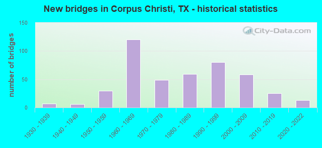
- New bridges - historical statistics
- 11920-1929
- 71930-1939
- 61940-1949
- 301950-1959
- 1201960-1969
- 491970-1979
- 591980-1989
- 801990-1999
- 582000-2009
- 252010-2019
- 132020-2022

- Reconstructed bridges - Historical Statistics
- 21940-1949
- 11950-1959
- 21960-1969
- 11970-1979
- 121980-1989
- 131990-1999
- 132000-2009
- 12010-2019


- Bridge Condition - Deck
- 1.5%Excellent
- 10.5%Very good
- 65.5%Good
- 22.0%Satisfactory
- 0.5%Fair

- Bridge Condition - Superstructure
- 1.0%Excellent
- 25.0%Very good
- 48.5%Good
- 22.0%Satisfactory
- 3.5%Fair

- Bridge Condition - Substructure
- 0.5%Excellent
- 5.0%Very good
- 55.0%Good
- 36.5%Satisfactory
- 1.5%Fair
- 1.5%Poor

- Bridge Condition - Channel
- 4.6%Very good
- 51.6%Good
- 35.9%Satisfactory
- 6.5%Fair
- 1.3%Poor

- Bridge Condition - Culverts
- 1.0%Very good
- 53.8%Good
- 41.3%Satisfactory
- 3.8%Fair
Find on map >> Show street view
Structure Number: 161780032603035, Location: 3.7 MI S OF IH 37 (Lat: 27.746672, Lng: -97.424414), Route carried "on" structure: State highway 286, Year Built: 1968, Year Reconstructed: 2004, Status: Open, Structure Length: 7.01m (23.00ft), Average Daily Traffic: 42,000 (year 2013), Truck Traffic: 4%, Average Future Daily Traffic: 58,800 (year 2033), Design Load: HS 20, Features Intersected: GOLLIHAR RD
Minimum Vertical Clearance: 30+ m (98+ ft), Kilometerpoint: 5.993, Lanes on structure: 3, Lanes under structure: 7, Base Highway Network: Yes, Owner: State Highway Agency, Approaching Roadway Width: 17.7m (58.1ft), Material/Design: Prestressed concrete, Design/Construction: Stringer/Multi-beam, Number Of Spans In Main Unit: 1, Number Of Approach Spans: 2, Length of Maximum Span: 29.0m (95.1ft), Curb-To-Curb Width: 17.5m (57.4ft), Out-to-Out Width: 18.4m (60.4ft)
Condition: Deck: Good, Superstructure: Good, Substructure: Satisfactory, Operating Rating: 60.8 metric tons, Method Used To Determine Operating Rating: Load Factor (LF), Inventory Rating: 27.2 metric tons, Method Used To Determine Inventory Rating: Load Factor (LF), Structural Evaluation: Equal to present minimum criteria, Deck Geometry: Better than present minimum criteria, Underclear: Meets minimum limits, Approach Roadway Alignment: Equal to present desirable criteria, Length Of Structure Improvement: 7.01m (23.00ft), Designated Inspection Frequency: Every 24 months, Inspection Date: July 2020, Deck Structure Type: Concrete Cast-file-Place, Wearing Surface/Protective System: Wearing Surface: Bituminous
Find on map >> Show street view
Structure Number: 161780032603071, Location: 0.6 MI S OF IH 37 (Lat: 27.787922, Lng: -97.409508), Route carried "on" structure: State highway 286, Year Built: 1964, Status: Open, Structure Length: 33.77m (110.79ft), Average Daily Traffic: 31,140 (year 2013), Truck Traffic: 7%, Average Future Daily Traffic: 43,590 (year 2033), Design Load: HS 20, Features Intersected: BU 44 (AGNES & LAREDO)
Minimum Vertical Clearance: 30+ m (98+ ft), Kilometerpoint: 0.946, Lanes on structure: 3, Lanes under structure: 6, Base Highway Network: Yes, Owner: State Highway Agency, Approaching Roadway Width: 18.3m (60.0ft), Skew: 19 degrees, Material/Design: Prestressed concrete, Design/Construction: Stringer/Multi-beam, Number Of Spans In Main Unit: 10, Number Of Approach Spans: 8, Length of Maximum Span: 25.0m (82.0ft), Curb-To-Curb Width: 12.2m (40.0ft), Out-to-Out Width: 13.6m (44.6ft)
Condition: Deck: Very good, Superstructure: Good, Substructure: Good, Operating Rating: 68.0 metric tons, Method Used To Determine Operating Rating: Load Factor (LF), Inventory Rating: 34.5 metric tons, Method Used To Determine Inventory Rating: Load Factor (LF), Structural Evaluation: Better than present minimum criteria, Deck Geometry: High priority of corrective action, Underclear: Meets minimum limits, Approach Roadway Alignment: Equal to present desirable criteria, Length Of Structure Improvement: 33.77m (110.79ft), Designated Inspection Frequency: Every 24 months, Inspection Date: June 2020, Deck Structure Type: Concrete Cast-file-Place
Find on map >> Show street view
Structure Number: 161780032603072, Location: 0.6 MI S OF IH 37 (Lat: 27.787897, Lng: -97.409417), Route carried "on" structure: State highway 286, Year Built: 1964, Status: Open, Structure Length: 33.74m (110.70ft), Average Daily Traffic: 31,140 (year 2013), Truck Traffic: 7%, Average Future Daily Traffic: 43,590 (year 2033), Design Load: HS 20, Features Intersected: BU 44 (AGNES & LAREDO)
Minimum Vertical Clearance: 30+ m (98+ ft), Kilometerpoint: 0.946, Lanes on structure: 3, Lanes under structure: 6, Base Highway Network: Yes, Owner: State Highway Agency, Approaching Roadway Width: 18.3m (60.0ft), Skew: 19 degrees, Material/Design: Prestressed concrete, Design/Construction: Stringer/Multi-beam, Number Of Spans In Main Unit: 11, Number Of Approach Spans: 7, Length of Maximum Span: 25.9m (85.0ft), Curb-To-Curb Width: 12.2m (40.0ft), Out-to-Out Width: 13.6m (44.6ft)
Condition: Deck: Very good, Superstructure: Very good, Substructure: Good, Operating Rating: 68.0 metric tons, Method Used To Determine Operating Rating: Load Factor (LF), Inventory Rating: 33.6 metric tons, Method Used To Determine Inventory Rating: Load Factor (LF), Structural Evaluation: Better than present minimum criteria, Deck Geometry: High priority of corrective action, Underclear: Meets minimum limits, Approach Roadway Alignment: Equal to present desirable criteria, Length Of Structure Improvement: 33.74m (110.70ft), Designated Inspection Frequency: Every 24 months, Inspection Date: June 2020, Deck Structure Type: Concrete Cast-file-Place, Wearing Surface/Protective System: Wearing Surface: Bituminous
Find on map >> Show street view
Structure Number: 1617800326031, Location: 0.30 MI S OF IH 37 (Lat: 27.793375, Lng: -97.409097), Route carried "on" structure: City street , Year Built: 2020, Status: Open, Structure Length: 9.08m (29.79ft), Average Daily Traffic: 3,300 (year 2015), Truck Traffic: 5%, Average Future Daily Traffic: 4,600 (year 2035), Design Load: HL 93, Features Intersected: SH 286, Facility Carried by Structure: COMANCHE ST
Minimum Vertical Clearance: 30+ m (98+ ft), Kilometerpoint: 0.515, Lanes on structure: 3, Lanes under structure: 9, Owner: State Highway Agency, Approaching Roadway Width: 12.2m (40.0ft), Material/Design: Prestressed concrete, Design/Construction: Stringer/Multi-beam, Number Of Spans In Main Unit: 3, Number Of Approach Spans: 1, Length of Maximum Span: 27.9m (91.5ft), Curb or Sidewalk Widths: Left: 1.7m (5.6ft), Right: 1.7m (5.6ft), Curb-To-Curb Width: 14.3m (46.9ft), Out-to-Out Width: 18.3m (60.0ft)
Condition: Deck: Good, Superstructure: Excellent, Substructure: Very good, Operating Rating: 54.4 metric tons, Method Used To Determine Operating Rating: Assigned ratings based on Load and Resistance Factor Design (LRFD) reported in metric tons, Inventory Rating: 32.7 metric tons, Method Used To Determine Inventory Rating: Assigned ratings based on Load and Resistance Factor Design (LRFD) reported in metric tons, Structural Evaluation: Equal to present desirable criteria, Deck Geometry: Somewhat better than minimum adequacy, Underclear: High priority of corrective action, Approach Roadway Alignment: Equal to present desirable criteria, Designated Inspection Frequency: Every 24 months, Inspection Date: August 2020, Deck Structure Type: Concrete Cast-file-Place
Find on map >> Show street view
Structure Number: 161780037301028, Location: 0.8 MI S OF IH 37 (Lat: 27.855822, Lng: -97.630092), Route carried "on" structure: US 77, Year Built: 1987, Status: Open, Structure Length: 8.99m (29.49ft), Average Daily Traffic: 10,222 (year 2020), Truck Traffic: 35%, Average Future Daily Traffic: 17,800 (year 2030), Design Load: HS 20, Features Intersected: FM 624
Minimum Vertical Clearance: 30+ m (98+ ft), Kilometerpoint: 1.292, Lanes on structure: 2, Lanes under structure: 8, Base Highway Network: Yes, Owner: State Highway Agency, Approaching Roadway Width: 13.4m (44.0ft), Skew: 1 degrees, Material/Design: Prestressed concrete, Design/Construction: Stringer/Multi-beam, Number Of Spans In Main Unit: 3, Length of Maximum Span: 35.1m (115.2ft), Curb-To-Curb Width: 13.7m (44.9ft), Out-to-Out Width: 14.3m (46.9ft)
Condition: Deck: Satisfactory, Superstructure: Good, Substructure: Good, Operating Rating: 54.4 metric tons, Method Used To Determine Operating Rating: Assigned rating based on Load Factor Design (LFD) reported in metric tons, Inventory Rating: 32.7 metric tons, Method Used To Determine Inventory Rating: Assigned rating based on Load Factor Design (LFD) reported in metric tons, Structural Evaluation: Better than present minimum criteria, Deck Geometry: Superior to present desirable criteria, Underclear: Somewhat better than minimum adequacy, Approach Roadway Alignment: Equal to present desirable criteria, Designated Inspection Frequency: Every 24 months, Inspection Date: May 2020, Deck Structure Type: Concrete Precast Panels
Find on map >> Show street view
Structure Number: 161780037301029, Location: 0.35 MI S OF FM 624 (Lat: 27.850689, Lng: -97.630986), Route carried "on" structure: US 77, Year Built: 1990, Status: Open, Structure Length: 0.79m (2.59ft), Average Daily Traffic: 19,631 (year 2020), Truck Traffic: 46%, Average Future Daily Traffic: 19,870 (year 2030), Design Load: HS 20, Features Intersected: DRAIN
Minimum Vertical Clearance: 30+ m (98+ ft), Kilometerpoint: 1.936, Lanes on structure: 10, Base Highway Network: Yes, Owner: State Highway Agency, Approaching Roadway Width: 58.2m (190.9ft), Skew: 23 degrees, Material/Design: Concrete, Design/Construction: Culvert, Number Of Spans In Main Unit: 2, Length of Maximum Span: 3.0m (9.8ft)
Condition: Channel: Good, Culverts: Good, Operating Rating: 39.9 metric tons, Method Used To Determine Operating Rating: Load Factor (LF), Inventory Rating: 23.6 metric tons, Method Used To Determine Inventory Rating: Load Factor (LF), Structural Evaluation: Somewhat better than minimum adequacy, Waterway Adequacy: Equal to present minimum criteria, Approach Roadway Alignment: Equal to present desirable criteria, Designated Inspection Frequency: Every 48 months, Inspection Date: May 2020
Find on map >> Show street view
Structure Number: 161780037301031, Location: 0.80 MI S OF IH 37 (Lat: 27.855800, Lng: -97.630200), Route carried "on" structure: US 77, Year Built: 1987, Status: Open, Structure Length: 8.99m (29.49ft), Average Daily Traffic: 9,409 (year 2020), Truck Traffic: 35%, Average Future Daily Traffic: 17,800 (year 2030), Design Load: HS 20, Features Intersected: FM 624
Minimum Vertical Clearance: 30+ m (98+ ft), Kilometerpoint: 1.292, Lanes on structure: 2, Lanes under structure: 8, Base Highway Network: Yes, Owner: State Highway Agency, Approaching Roadway Width: 13.4m (44.0ft), Skew: 1 degrees, Material/Design: Prestressed concrete, Design/Construction: Stringer/Multi-beam, Number Of Spans In Main Unit: 3, Length of Maximum Span: 35.1m (115.2ft), Curb-To-Curb Width: 13.7m (44.9ft), Out-to-Out Width: 14.3m (46.9ft)
Condition: Deck: Satisfactory, Superstructure: Good, Substructure: Satisfactory, Operating Rating: 54.4 metric tons, Method Used To Determine Operating Rating: Assigned rating based on Load Factor Design (LFD) reported in metric tons, Inventory Rating: 32.7 metric tons, Method Used To Determine Inventory Rating: Assigned rating based on Load Factor Design (LFD) reported in metric tons, Structural Evaluation: Equal to present minimum criteria, Deck Geometry: Superior to present desirable criteria, Underclear: Equal to present minimum criteria, Approach Roadway Alignment: Equal to present desirable criteria, Designated Inspection Frequency: Every 24 months, Inspection Date: May 2020, Deck Structure Type: Concrete Precast Panels
Find on map >> Show street view
Structure Number: 161780037301033, Location: 1.8 MI S OF FM 624 (Lat: 27.830164, Lng: -97.634750), Route carried "on" structure: US 77, Year Built: 2006, Status: Open, Structure Length: 9.75m (31.99ft), Average Daily Traffic: 10,222 (year 2020), Truck Traffic: 46%, Average Future Daily Traffic: 9,930 (year 2030), Design Load: HL 93, Features Intersected: CR 48
Minimum Vertical Clearance: 30+ m (98+ ft), Kilometerpoint: 4.186, Lanes on structure: 2, Lanes under structure: 4, Base Highway Network: Yes, Owner: State Highway Agency, Approaching Roadway Width: 11.6m (38.1ft), Material/Design: Prestressed concrete, Design/Construction: Stringer/Multi-beam, Number Of Spans In Main Unit: 3, Length of Maximum Span: 36.6m (120.1ft), Curb-To-Curb Width: 11.5m (37.7ft), Out-to-Out Width: 12.2m (40.0ft)
Condition: Deck: Satisfactory, Superstructure: Good, Substructure: Good, Operating Rating: 54.4 metric tons, Method Used To Determine Operating Rating: Assigned ratings based on Load and Resistance Factor Design (LRFD) reported in metric tons, Inventory Rating: 32.7 metric tons, Method Used To Determine Inventory Rating: Assigned ratings based on Load and Resistance Factor Design (LRFD) reported in metric tons, Structural Evaluation: Better than present minimum criteria, Deck Geometry: Equal to present minimum criteria, Underclear: Superior to present desirable criteria, Approach Roadway Alignment: Equal to present desirable criteria, Designated Inspection Frequency: Every 24 months, Inspection Date: May 2020, Deck Structure Type: Concrete Precast Panels
Find on map >> Show street view
Structure Number: 161780037301034, Location: 1.8 MI S OF FM 624 (Lat: 27.830989, Lng: -97.634958), Route carried "on" structure: US 77, Year Built: 2006, Status: Open, Structure Length: 9.75m (31.99ft), Average Daily Traffic: 9,409 (year 2020), Truck Traffic: 46%, Average Future Daily Traffic: 9,930 (year 2030), Design Load: HL 93, Features Intersected: CR 48
Minimum Vertical Clearance: 30+ m (98+ ft), Kilometerpoint: 4.186, Lanes on structure: 2, Lanes under structure: 4, Base Highway Network: Yes, Owner: State Highway Agency, Approaching Roadway Width: 11.6m (38.1ft), Material/Design: Prestressed concrete, Design/Construction: Stringer/Multi-beam, Number Of Spans In Main Unit: 3, Length of Maximum Span: 36.6m (120.1ft), Curb-To-Curb Width: 11.3m (37.1ft), Out-to-Out Width: 12.2m (40.0ft)
Condition: Deck: Satisfactory, Superstructure: Good, Substructure: Good, Operating Rating: 54.4 metric tons, Method Used To Determine Operating Rating: Assigned ratings based on Load and Resistance Factor Design (LRFD) reported in metric tons, Inventory Rating: 32.7 metric tons, Method Used To Determine Inventory Rating: Assigned ratings based on Load and Resistance Factor Design (LRFD) reported in metric tons, Structural Evaluation: Better than present minimum criteria, Deck Geometry: Equal to present minimum criteria, Underclear: Superior to present desirable criteria, Approach Roadway Alignment: Equal to present desirable criteria, Designated Inspection Frequency: Every 24 months, Inspection Date: May 2020, Deck Structure Type: Concrete Precast Panels
Find on map >> Show street view
Structure Number: 161780037301035, Location: 0.7 MI S OF FM 624 (Lat: 27.846850, Lng: -97.631558), Route carried "on" structure: US 77, Year Built: 2006, Status: Open, Structure Length: 9.75m (31.99ft), Average Daily Traffic: 10,222 (year 2020), Truck Traffic: 46%, Average Future Daily Traffic: 9,930 (year 2030), Design Load: HL 93, Features Intersected: CR 52
Minimum Vertical Clearance: 30+ m (98+ ft), Kilometerpoint: 2.274, Lanes on structure: 2, Lanes under structure: 4, Base Highway Network: Yes, Owner: State Highway Agency, Approaching Roadway Width: 11.6m (38.1ft), Material/Design: Prestressed concrete, Design/Construction: Stringer/Multi-beam, Number Of Spans In Main Unit: 3, Length of Maximum Span: 36.6m (120.1ft), Curb-To-Curb Width: 11.5m (37.7ft), Out-to-Out Width: 12.2m (40.0ft)
Condition: Deck: Satisfactory, Superstructure: Very good, Substructure: Good, Operating Rating: 54.4 metric tons, Method Used To Determine Operating Rating: Assigned ratings based on Load and Resistance Factor Design (LRFD) reported in metric tons, Inventory Rating: 32.7 metric tons, Method Used To Determine Inventory Rating: Assigned ratings based on Load and Resistance Factor Design (LRFD) reported in metric tons, Structural Evaluation: Better than present minimum criteria, Deck Geometry: Equal to present minimum criteria, Underclear: Superior to present desirable criteria, Approach Roadway Alignment: Equal to present desirable criteria, Designated Inspection Frequency: Every 24 months, Inspection Date: May 2020, Deck Structure Type: Concrete Precast Panels
Find on map >> Show street view
Structure Number: 161780037301036, Location: 0.7 MI S OF FM 624 (Lat: 27.847814, Lng: -97.631686), Route carried "on" structure: US 77, Year Built: 2006, Status: Open, Structure Length: 9.75m (31.99ft), Average Daily Traffic: 9,409 (year 2020), Truck Traffic: 46%, Average Future Daily Traffic: 9,930 (year 2030), Design Load: HL 93, Features Intersected: CR 52
Minimum Vertical Clearance: 30+ m (98+ ft), Kilometerpoint: 2.274, Lanes on structure: 2, Lanes under structure: 4, Base Highway Network: Yes, Owner: State Highway Agency, Approaching Roadway Width: 11.6m (38.1ft), Material/Design: Prestressed concrete, Design/Construction: Stringer/Multi-beam, Number Of Spans In Main Unit: 3, Length of Maximum Span: 36.6m (120.1ft), Curb-To-Curb Width: 11.3m (37.1ft), Out-to-Out Width: 12.2m (40.0ft)
Condition: Deck: Satisfactory, Superstructure: Very good, Substructure: Good, Operating Rating: 54.4 metric tons, Method Used To Determine Operating Rating: Assigned ratings based on Load and Resistance Factor Design (LRFD) reported in metric tons, Inventory Rating: 32.7 metric tons, Method Used To Determine Inventory Rating: Assigned ratings based on Load and Resistance Factor Design (LRFD) reported in metric tons, Structural Evaluation: Better than present minimum criteria, Deck Geometry: Equal to present minimum criteria, Underclear: Superior to present desirable criteria, Approach Roadway Alignment: Equal to present desirable criteria, Designated Inspection Frequency: Every 24 months, Inspection Date: May 2020, Deck Structure Type: Concrete Precast Panels
Find on map >> Show street view
Structure Number: 161780037301037, Location: 1.4 MI S OF FM 624 (Lat: 27.837031, Lng: -97.633164), Route carried "on" structure: US 77, Year Built: 2006, Status: Open, Structure Length: 0.79m (2.59ft), Average Daily Traffic: 19,631 (year 2020), Truck Traffic: 46%, Average Future Daily Traffic: 19,870 (year 2030), Design Load: HS 20, Features Intersected: DRAW
Minimum Vertical Clearance: 30+ m (98+ ft), Kilometerpoint: 3.478, Lanes on structure: 9, Owner: State Highway Agency, Approaching Roadway Width: 53.3m (174.9ft), Material/Design: Concrete, Design/Construction: Culvert, Number Of Spans In Main Unit: 3, Length of Maximum Span: 2.1m (6.9ft), Curb or Sidewalk Widths: Left: 0.3m (1.0ft), Right: 0.0m, Curb-To-Curb Width: 53.3m (174.9ft), Out-to-Out Width: 86.6m (284.1ft)
Condition: Channel: Good, Culverts: Good, Operating Rating: 44.4 metric tons, Method Used To Determine Operating Rating: Assigned rating based on Load Factor Design (LFD) reported in metric tons, Inventory Rating: 32.7 metric tons, Method Used To Determine Inventory Rating: Assigned rating based on Load Factor Design (LFD) reported in metric tons, Structural Evaluation: Better than present minimum criteria, Deck Geometry: Superior to present desirable criteria, Waterway Adequacy: Equal to present minimum criteria, Approach Roadway Alignment: Equal to present desirable criteria, Designated Inspection Frequency: Every 48 months, Inspection Date: July 2018, Deck Structure Type: Concrete Cast-file-Place, Wearing Surface/Protective System: Wearing Surface: Bituminous
Find on map >> Show street view
Structure Number: 161780037301038, Location: US 77 AT IH 37 (Lat: 27.863353, Lng: -97.623975), Route carried "on" structure: Ramp US 77, Year Built: 2007, Status: Open, Structure Length: 30.45m (99.90ft), Average Daily Traffic: 2,700 (year 2011), Truck Traffic: 5%, Average Future Daily Traffic: 4,100 (year 2031), Design Load: HS 25 or greater, Features Intersected: US 77 SB, Facility Carried by Structure: FM 624 CONN
Minimum Vertical Clearance: 30+ m (98+ ft), Kilometerpoint: 0.275, Lanes on structure: 1, Lanes under structure: 3, Base Highway Network: Yes, Owner: State Highway Agency, Approaching Roadway Width: 7.9m (25.9ft), Material/Design: Steel, Design/Construction: Stringer/Multi-beam, Number Of Spans In Main Unit: 1, Number Of Approach Spans: 7, Length of Maximum Span: 61.0m (200.1ft), Curb-To-Curb Width: 7.7m (25.3ft), Out-to-Out Width: 8.5m (27.9ft)
Condition: Deck: Good, Superstructure: Very good, Substructure: Good, Operating Rating: 68.0 metric tons, Method Used To Determine Operating Rating: Assigned rating based on Load Factor Design (LFD) reported in metric tons, Inventory Rating: 40.8 metric tons, Method Used To Determine Inventory Rating: Assigned rating based on Load Factor Design (LFD) reported in metric tons, Structural Evaluation: Better than present minimum criteria, Deck Geometry: Better than present minimum criteria, Underclear: High priority of corrective action, Approach Roadway Alignment: Somewhat better than minimum adequacy, Designated Inspection Frequency: Every 24 months, Critical Feature Inspection Frequency: Every 24 months, Inspection Date: May 2020, Critical Feature Inspection Date: April 2020, Deck Structure Type: Concrete Precast Panels
Find on map >> Show street view
Structure Number: 161780061701019, Location: 2.5 MI E OF FM 43 (Lat: 27.704019, Lng: -97.362822), Route carried "on" structure: State highway 358, Year Built: 1972, Status: Open, Structure Length: 7.92m (25.98ft), Average Daily Traffic: 60,940 (year 2013), Truck Traffic: 5%, Average Future Daily Traffic: 85,320 (year 2033), Design Load: HS 20, Features Intersected: AIRLINE RD
Minimum Vertical Clearance: 30+ m (98+ ft), Kilometerpoint: 16.858, Lanes on structure: 6, Lanes under structure: 8, Base Highway Network: Yes, Owner: State Highway Agency, Approaching Roadway Width: 32.6m (107.0ft), Skew: 32 degrees, Material/Design: Prestressed concrete, Design/Construction: Stringer/Multi-beam, Number Of Spans In Main Unit: 1, Number Of Approach Spans: 2, Length of Maximum Span: 34.1m (111.9ft), Curb-To-Curb Width: 32.7m (107.3ft), Out-to-Out Width: 34.2m (112.2ft)
Condition: Deck: Good, Superstructure: Good, Substructure: Good, Operating Rating: 64.4 metric tons, Method Used To Determine Operating Rating: Load Factor (LF), Inventory Rating: 29.9 metric tons, Method Used To Determine Inventory Rating: Load Factor (LF), Structural Evaluation: Better than present minimum criteria, Deck Geometry: Superior to present desirable criteria, Underclear: Equal to present minimum criteria, Approach Roadway Alignment: Equal to present desirable criteria, Designated Inspection Frequency: Every 24 months, Inspection Date: July 2020, Deck Structure Type: Concrete Cast-file-Place
Find on map >> Show street view
Structure Number: 16178006170102, Location: 2.0 MI E OF FM 43 (Lat: 27.707667, Lng: -97.370011), Route carried "on" structure: State highway 358, Year Built: 1972, Status: Open, Structure Length: 7.16m (23.49ft), Average Daily Traffic: 43,210 (year 2013), Truck Traffic: 7%, Average Future Daily Traffic: 60,500 (year 2033), Design Load: HS 20, Features Intersected: STAPLES ST
Minimum Vertical Clearance: 30+ m (98+ ft), Kilometerpoint: 16.031, Lanes on structure: 3, Lanes under structure: 8, Base Highway Network: Yes, Owner: State Highway Agency, Approaching Roadway Width: 16.2m (53.1ft), Material/Design: Prestressed concrete, Design/Construction: Stringer/Multi-beam, Number Of Spans In Main Unit: 1, Number Of Approach Spans: 2, Length of Maximum Span: 31.4m (103.0ft), Curb-To-Curb Width: 16.1m (52.8ft), Out-to-Out Width: 16.5m (54.1ft)
Condition: Deck: Good, Superstructure: Good, Substructure: Good, Operating Rating: 44.4 metric tons, Method Used To Determine Operating Rating: Assigned rating based on Load Factor Design (LFD) reported in metric tons, Inventory Rating: 32.7 metric tons, Method Used To Determine Inventory Rating: Assigned rating based on Load Factor Design (LFD) reported in metric tons, Structural Evaluation: Better than present minimum criteria, Deck Geometry: Equal to present minimum criteria, Underclear: Equal to present minimum criteria, Approach Roadway Alignment: Equal to present desirable criteria, Designated Inspection Frequency: Every 24 months, Inspection Date: July 2020, Deck Structure Type: Concrete Cast-file-Place
Find on map >> Show street view
Structure Number: 161780061701021, Location: 1.0 MI E OF FM 43 (Lat: 27.714572, Lng: -97.384394), Route carried "on" structure: State highway 358, Year Built: 1972, Status: Open, Structure Length: 7.07m (23.20ft), Average Daily Traffic: 43,210 (year 2013), Truck Traffic: 7%, Average Future Daily Traffic: 60,500 (year 2033), Design Load: HS 20, Features Intersected: EVERHART RD
Minimum Vertical Clearance: 30+ m (98+ ft), Kilometerpoint: 14.421, Lanes on structure: 3, Lanes under structure: 8, Base Highway Network: Yes, Owner: State Highway Agency, Approaching Roadway Width: 16.2m (53.1ft), Material/Design: Prestressed concrete, Design/Construction: Stringer/Multi-beam, Number Of Spans In Main Unit: 1, Number Of Approach Spans: 2, Length of Maximum Span: 30.5m (100.1ft), Curb-To-Curb Width: 16.1m (52.8ft), Out-to-Out Width: 16.5m (54.1ft)
Condition: Deck: Good, Superstructure: Satisfactory, Substructure: Good, Operating Rating: 68.0 metric tons, Method Used To Determine Operating Rating: Load Factor (LF), Inventory Rating: 29.9 metric tons, Method Used To Determine Inventory Rating: Load Factor (LF), Structural Evaluation: Equal to present minimum criteria, Deck Geometry: Equal to present minimum criteria, Underclear: Equal to present minimum criteria, Approach Roadway Alignment: Equal to present desirable criteria, Designated Inspection Frequency: Every 24 months, Inspection Date: July 2020, Deck Structure Type: Concrete Cast-file-Place
Find on map >> Show street view
Structure Number: 161780061701023, Location: 2.3 MI E OF SH 286 (Lat: 27.721519, Lng: -97.398661), Route carried "on" structure: State highway 358, Year Built: 1972, Status: Open, Structure Length: 7.07m (23.20ft), Average Daily Traffic: 63,120 (year 2013), Truck Traffic: 7%, Average Future Daily Traffic: 88,370 (year 2033), Design Load: HS 20, Features Intersected: WEBER RD
Minimum Vertical Clearance: 30+ m (98+ ft), Kilometerpoint: 12.814, Lanes on structure: 3, Lanes under structure: 8, Base Highway Network: Yes, Owner: State Highway Agency, Approaching Roadway Width: 16.2m (53.1ft), Material/Design: Prestressed concrete, Design/Construction: Stringer/Multi-beam, Number Of Spans In Main Unit: 1, Number Of Approach Spans: 2, Length of Maximum Span: 30.5m (100.1ft), Curb-To-Curb Width: 16.1m (52.8ft), Out-to-Out Width: 16.5m (54.1ft)
Condition: Deck: Good, Superstructure: Good, Substructure: Good, Operating Rating: 68.0 metric tons, Method Used To Determine Operating Rating: Load Factor (LF), Inventory Rating: 29.9 metric tons, Method Used To Determine Inventory Rating: Load Factor (LF), Structural Evaluation: Better than present minimum criteria, Deck Geometry: Equal to present minimum criteria, Underclear: Equal to present minimum criteria, Approach Roadway Alignment: Equal to present desirable criteria, Designated Inspection Frequency: Every 24 months, Inspection Date: July 2020, Deck Structure Type: Concrete Cast-file-Place
Find on map >> Show street view
Structure Number: 161780061701024, Location: 0.5 MI W OF FM 43 (Lat: 27.725039, Lng: -97.405858), Route carried "on" structure: State highway 358, Year Built: 1972, Status: Open, Structure Length: 7.07m (23.20ft), Average Daily Traffic: 63,120 (year 2013), Truck Traffic: 7%, Average Future Daily Traffic: 88,370 (year 2033), Design Load: HS 20, Features Intersected: CARROLL LANE
Minimum Vertical Clearance: 30+ m (98+ ft), Kilometerpoint: 12.009, Lanes on structure: 3, Lanes under structure: 7, Base Highway Network: Yes, Owner: State Highway Agency, Approaching Roadway Width: 15.9m (52.2ft), Material/Design: Prestressed concrete, Design/Construction: Stringer/Multi-beam, Number Of Spans In Main Unit: 1, Number Of Approach Spans: 2, Length of Maximum Span: 30.5m (100.1ft), Curb-To-Curb Width: 16.2m (53.1ft), Out-to-Out Width: 16.5m (54.1ft)
Condition: Deck: Good, Superstructure: Good, Substructure: Good, Operating Rating: 68.0 metric tons, Method Used To Determine Operating Rating: Load Factor (LF), Inventory Rating: 29.0 metric tons, Method Used To Determine Inventory Rating: Load Factor (LF), Structural Evaluation: Better than present minimum criteria, Deck Geometry: Equal to present minimum criteria, Underclear: Equal to present minimum criteria, Approach Roadway Alignment: Equal to present desirable criteria, Designated Inspection Frequency: Every 24 months, Inspection Date: July 2020, Deck Structure Type: Concrete Cast-file-Place
Find on map >> Show street view
Structure Number: 161780061701025, Location: 1.0 MI E OF SH 286 (Lat: 27.728475, Lng: -97.412953), Route carried "on" structure: State highway 358, Year Built: 1972, Status: Open, Structure Length: 7.07m (23.20ft), Average Daily Traffic: 52,340 (year 2010), Truck Traffic: 5%, Average Future Daily Traffic: 75,240 (year 2030), Design Load: HS 20, Features Intersected: KOSTORYZ RD
Minimum Vertical Clearance: 30+ m (98+ ft), Kilometerpoint: 11.203, Lanes on structure: 3, Lanes under structure: 8, Base Highway Network: Yes, Owner: State Highway Agency, Approaching Roadway Width: 16.2m (53.1ft), Material/Design: Prestressed concrete, Design/Construction: Stringer/Multi-beam, Number Of Spans In Main Unit: 1, Number Of Approach Spans: 2, Length of Maximum Span: 30.5m (100.1ft), Curb-To-Curb Width: 16.2m (53.1ft), Out-to-Out Width: 16.5m (54.1ft)
Condition: Deck: Good, Superstructure: Good, Substructure: Good, Operating Rating: 68.0 metric tons, Method Used To Determine Operating Rating: Load Factor (LF), Inventory Rating: 29.9 metric tons, Method Used To Determine Inventory Rating: Load Factor (LF), Structural Evaluation: Better than present minimum criteria, Deck Geometry: Equal to present minimum criteria, Underclear: Equal to present minimum criteria, Approach Roadway Alignment: Equal to present desirable criteria, Designated Inspection Frequency: Every 24 months, Inspection Date: July 2020, Deck Structure Type: Concrete Cast-file-Place
Find on map >> Show street view
Structure Number: 161780061701034, Location: 0.79 MI W OF SH 286 (Lat: 27.742569, Lng: -97.441606), Route carried "on" structure: State highway 358, Year Built: 1982, Year Reconstructed: 2006, Status: Open, Structure Length: 7.07m (23.20ft), Average Daily Traffic: 73,724 (year 2020), Truck Traffic: 5%, Average Future Daily Traffic: 87,200 (year 2033), Design Load: HS 20, Features Intersected: GREENWOOD DR
Minimum Vertical Clearance: 30+ m (98+ ft), Kilometerpoint: 7.984, Lanes on structure: 8, Lanes under structure: 8, Base Highway Network: Yes, Owner: State Highway Agency, Approaching Roadway Width: 42.1m (138.1ft), Skew: 30 degrees, Material/Design: Prestressed concrete, Design/Construction: Stringer/Multi-beam, Number Of Spans In Main Unit: 1, Number Of Approach Spans: 2, Length of Maximum Span: 30.5m (100.1ft), Curb-To-Curb Width: 41.7m (136.8ft), Out-to-Out Width: 43.3m (142.1ft)
Condition: Deck: Good, Superstructure: Good, Substructure: Good, Operating Rating: 54.4 metric tons, Method Used To Determine Operating Rating: Assigned rating based on Load Factor Design (LFD) reported in metric tons, Inventory Rating: 32.7 metric tons, Method Used To Determine Inventory Rating: Assigned rating based on Load Factor Design (LFD) reported in metric tons, Structural Evaluation: Better than present minimum criteria, Deck Geometry: Superior to present desirable criteria, Underclear: Better than present minimum criteria, Approach Roadway Alignment: Equal to present desirable criteria, Designated Inspection Frequency: Every 24 months, Inspection Date: July 2020, Deck Structure Type: Concrete Precast Panels
Find on map >> Show street view
Structure Number: 161780061701039, Location: 2.0 MI E OF FM 43 (Lat: 27.707597, Lng: -97.370075), Route carried "on" structure: State highway 358, Year Built: 1972, Status: Open, Structure Length: 7.16m (23.49ft), Average Daily Traffic: 43,210 (year 2013), Truck Traffic: 7%, Average Future Daily Traffic: 60,500 (year 2033), Design Load: HS 20, Features Intersected: STAPLES ST
Minimum Vertical Clearance: 30+ m (98+ ft), Kilometerpoint: 16.031, Lanes on structure: 3, Lanes under structure: 8, Base Highway Network: Yes, Owner: State Highway Agency, Approaching Roadway Width: 16.8m (55.1ft), Material/Design: Prestressed concrete, Design/Construction: Stringer/Multi-beam, Number Of Spans In Main Unit: 1, Number Of Approach Spans: 2, Length of Maximum Span: 31.4m (103.0ft), Curb-To-Curb Width: 16.6m (54.5ft), Out-to-Out Width: 17.7m (58.1ft)
Condition: Deck: Good, Superstructure: Good, Substructure: Good, Operating Rating: 68.0 metric tons, Method Used To Determine Operating Rating: Load Factor (LF), Inventory Rating: 38.1 metric tons, Method Used To Determine Inventory Rating: Load Factor (LF), Structural Evaluation: Better than present minimum criteria, Deck Geometry: Equal to present minimum criteria, Underclear: Equal to present minimum criteria, Approach Roadway Alignment: Equal to present desirable criteria, Designated Inspection Frequency: Every 24 months, Inspection Date: July 2020, Deck Structure Type: Concrete Cast-file-Place
Find on map >> Show street view
Structure Number: 16178006170104, Location: 1.0 MI E OF FM 43 (Lat: 27.714667, Lng: -97.384333), Route carried "on" structure: State highway 358, Year Built: 1972, Year Reconstructed: 2008, Status: Open, Structure Length: 7.07m (23.20ft), Average Daily Traffic: 43,210 (year 2013), Truck Traffic: 7%, Average Future Daily Traffic: 60,500 (year 2033), Design Load: HS 20, Features Intersected: EVERHART RD
Minimum Vertical Clearance: 30+ m (98+ ft), Kilometerpoint: 14.421, Lanes on structure: 4, Lanes under structure: 8, Base Highway Network: Yes, Owner: State Highway Agency, Approaching Roadway Width: 19.5m (64.0ft), Material/Design: Prestressed concrete, Design/Construction: Stringer/Multi-beam, Number Of Spans In Main Unit: 1, Number Of Approach Spans: 2, Length of Maximum Span: 30.5m (100.1ft), Curb-To-Curb Width: 19.4m (63.6ft), Out-to-Out Width: 20.4m (66.9ft)
Condition: Deck: Good, Superstructure: Satisfactory, Substructure: Good, Operating Rating: 68.0 metric tons, Method Used To Determine Operating Rating: Load Factor (LF), Inventory Rating: 29.0 metric tons, Method Used To Determine Inventory Rating: Load Factor (LF), Structural Evaluation: Equal to present minimum criteria, Deck Geometry: Somewhat better than minimum adequacy, Underclear: Equal to present minimum criteria, Approach Roadway Alignment: Equal to present desirable criteria, Designated Inspection Frequency: Every 24 months, Inspection Date: July 2020, Deck Structure Type: Concrete Cast-file-Place
Find on map >> Show street view
Structure Number: 161780061701041, Location: 2.3 MI E OF SH 286 (Lat: 27.721606, Lng: -97.398597), Route carried "on" structure: State highway 358, Year Built: 1972, Year Reconstructed: 2008, Status: Open, Structure Length: 7.07m (23.20ft), Average Daily Traffic: 63,120 (year 2013), Truck Traffic: 7%, Average Future Daily Traffic: 88,370 (year 2033), Design Load: HS 20, Features Intersected: WEBER RD
Minimum Vertical Clearance: 30+ m (98+ ft), Kilometerpoint: 12.814, Lanes on structure: 4, Lanes under structure: 8, Base Highway Network: Yes, Owner: State Highway Agency, Approaching Roadway Width: 19.2m (63.0ft), Material/Design: Prestressed concrete, Design/Construction: Stringer/Multi-beam, Number Of Spans In Main Unit: 1, Number Of Approach Spans: 2, Length of Maximum Span: 30.5m (100.1ft), Curb-To-Curb Width: 19.4m (63.6ft), Out-to-Out Width: 20.4m (66.9ft)
Condition: Deck: Good, Superstructure: Good, Substructure: Good, Operating Rating: 68.0 metric tons, Method Used To Determine Operating Rating: Load Factor (LF), Inventory Rating: 29.0 metric tons, Method Used To Determine Inventory Rating: Load Factor (LF), Structural Evaluation: Better than present minimum criteria, Deck Geometry: Somewhat better than minimum adequacy, Underclear: Equal to present minimum criteria, Approach Roadway Alignment: Equal to present desirable criteria, Designated Inspection Frequency: Every 24 months, Inspection Date: July 2020, Deck Structure Type: Concrete Cast-file-Place
Find on map >> Show street view
Structure Number: 161780061701042, Location: 0.50 MI W OF FM 43 (Lat: 27.725131, Lng: -97.405800), Route carried "on" structure: State highway 358, Year Built: 1972, Year Reconstructed: 2006, Status: Open, Structure Length: 7.07m (23.20ft), Average Daily Traffic: 52,340 (year 2010), Truck Traffic: 5%, Average Future Daily Traffic: 75,240 (year 2030), Design Load: HS 20, Features Intersected: CARROLL LANE
Minimum Vertical Clearance: 30+ m (98+ ft), Kilometerpoint: 12.009, Lanes on structure: 4, Lanes under structure: 7, Base Highway Network: Yes, Owner: State Highway Agency, Approaching Roadway Width: 19.2m (63.0ft), Material/Design: Prestressed concrete, Design/Construction: Stringer/Multi-beam, Number Of Spans In Main Unit: 1, Number Of Approach Spans: 2, Length of Maximum Span: 30.5m (100.1ft), Curb-To-Curb Width: 19.3m (63.3ft), Out-to-Out Width: 20.4m (66.9ft)
Condition: Deck: Good, Superstructure: Good, Substructure: Good, Operating Rating: 68.0 metric tons, Method Used To Determine Operating Rating: Load Factor (LF), Inventory Rating: 24.5 metric tons, Method Used To Determine Inventory Rating: Load Factor (LF), Structural Evaluation: Equal to present minimum criteria, Deck Geometry: Somewhat better than minimum adequacy, Underclear: Somewhat better than minimum adequacy, Approach Roadway Alignment: Equal to present desirable criteria, Length Of Structure Improvement: 7.07m (23.20ft), Designated Inspection Frequency: Every 24 months, Inspection Date: July 2020, Deck Structure Type: Concrete Cast-file-Place, Wearing Surface/Protective System: Wearing Surface: Bituminous
Find on map >> Show street view
Structure Number: 161780061701043, Location: 1.0 MI W OF FM 43 (Lat: 27.728572, Lng: -97.412883), Route carried "on" structure: State highway 358, Year Built: 1972, Year Reconstructed: 2006, Status: Open, Structure Length: 7.07m (23.20ft), Average Daily Traffic: 63,120 (year 2013), Truck Traffic: 7%, Average Future Daily Traffic: 88,370 (year 2033), Design Load: HS 20, Features Intersected: KOSTORYZ RD
Minimum Vertical Clearance: 30+ m (98+ ft), Kilometerpoint: 11.203, Lanes on structure: 4, Lanes under structure: 8, Base Highway Network: Yes, Owner: State Highway Agency, Approaching Roadway Width: 19.5m (64.0ft), Material/Design: Prestressed concrete, Design/Construction: Stringer/Multi-beam, Number Of Spans In Main Unit: 1, Number Of Approach Spans: 2, Length of Maximum Span: 30.5m (100.1ft), Curb-To-Curb Width: 19.4m (63.6ft), Out-to-Out Width: 20.4m (66.9ft)
Condition: Deck: Good, Superstructure: Good, Substructure: Good, Operating Rating: 68.0 metric tons, Method Used To Determine Operating Rating: Load Factor (LF), Inventory Rating: 24.5 metric tons, Method Used To Determine Inventory Rating: Load Factor (LF), Structural Evaluation: Equal to present minimum criteria, Deck Geometry: Somewhat better than minimum adequacy, Underclear: Better than present minimum criteria, Approach Roadway Alignment: Equal to present desirable criteria, Designated Inspection Frequency: Every 24 months, Inspection Date: July 2020, Deck Structure Type: Concrete Cast-file-Place, Wearing Surface/Protective System: Wearing Surface: Bituminous
Find on map >> Show street view
Structure Number: 161780061701044, Location: 1.00 MI W OF SH 286 (Lat: 27.744072, Lng: -97.444761), Route carried "on" structure: State highway 358, Year Built: 1982, Status: Open, Structure Length: 0.91m (2.99ft), Average Daily Traffic: 67,405 (year 2020), Truck Traffic: 5%, Average Future Daily Traffic: 87,200 (year 2033), Design Load: HS 20, Features Intersected: AIRPORT DITCH
Minimum Vertical Clearance: 30+ m (98+ ft), Kilometerpoint: 7.643, Lanes on structure: 14, Owner: State Highway Agency, Approaching Roadway Width: 72.2m (236.9ft), Skew: 30 degrees, Material/Design: Concrete, Design/Construction: Culvert, Number Of Spans In Main Unit: 3, Length of Maximum Span: 2.7m (8.9ft)
Condition: Channel: Good, Culverts: Good, Operating Rating: 39.9 metric tons, Method Used To Determine Operating Rating: Load Factor (LF), Inventory Rating: 23.6 metric tons, Method Used To Determine Inventory Rating: Load Factor (LF), Structural Evaluation: Somewhat better than minimum adequacy, Waterway Adequacy: Equal to present minimum criteria, Approach Roadway Alignment: Equal to present desirable criteria, Designated Inspection Frequency: Every 48 months, Inspection Date: June 2018
Find on map >> Show street view
Structure Number: 161780061701045, Location: 0.2 MI E OF FM 665 (Lat: 27.753964, Lng: -97.458031), Route carried "on" structure: State highway 358, Year Built: 1982, Status: Open, Structure Length: 0.73m (2.40ft), Average Daily Traffic: 67,405 (year 2020), Truck Traffic: 5%, Average Future Daily Traffic: 87,200 (year 2033), Design Load: HS 20, Features Intersected: WEST OSO DITCH
Minimum Vertical Clearance: 30+ m (98+ ft), Kilometerpoint: 5.992, Lanes on structure: 14, Base Highway Network: Yes, Owner: State Highway Agency, Approaching Roadway Width: 76.2m (250.0ft), Material/Design: Concrete, Design/Construction: Culvert, Number Of Spans In Main Unit: 3, Length of Maximum Span: 2.1m (6.9ft), Curb or Sidewalk Widths: Left: 1.2m (3.9ft), Right: 1.2m (3.9ft)
Condition: Channel: Good, Culverts: Satisfactory, Operating Rating: 39.9 metric tons, Method Used To Determine Operating Rating: Load Factor (LF), Inventory Rating: 23.6 metric tons, Method Used To Determine Inventory Rating: Load Factor (LF), Structural Evaluation: Somewhat better than minimum adequacy, Waterway Adequacy: Equal to present minimum criteria, Approach Roadway Alignment: Equal to present desirable criteria, Designated Inspection Frequency: Every 48 months, Inspection Date: July 2020
Find on map >> Show street view
Structure Number: 161780061701049, Location: 5.90 MI E OF FM 43 (Lat: 27.680961, Lng: -97.314675), Route carried "on" structure: State highway 358, Year Built: 1986, Status: Open, Structure Length: 59.71m (195.90ft), Average Daily Traffic: 22,910 (year 2013), Truck Traffic: 7%, Average Future Daily Traffic: 32,080 (year 2033), Design Load: HS 20, Features Intersected: CAYO DEL OSO
Minimum Vertical Clearance: 30+ m (98+ ft), Kilometerpoint: 22.278, Lanes on structure: 3, Owner: State Highway Agency, Approaching Roadway Width: 16.2m (53.1ft), Material/Design: Prestressed concrete, Design/Construction: Stringer/Multi-beam, Number Of Spans In Main Unit: 25, Number Of Approach Spans: 1, Length of Maximum Span: 24.4m (80.1ft), Curb-To-Curb Width: 16.0m (52.5ft), Out-to-Out Width: 17.7m (58.1ft)
Condition: Deck: Very good, Superstructure: Satisfactory, Substructure: Good, Channel: Satisfactory, Operating Rating: 54.4 metric tons, Method Used To Determine Operating Rating: Assigned rating based on Load Factor Design (LFD) reported in metric tons, Inventory Rating: 32.7 metric tons, Method Used To Determine Inventory Rating: Assigned rating based on Load Factor Design (LFD) reported in metric tons, Structural Evaluation: Equal to present minimum criteria, Deck Geometry: Equal to present minimum criteria, Waterway Adequacy: Superior to present desirable criteria, Approach Roadway Alignment: Equal to present desirable criteria, Length Of Structure Improvement: 59.71m (195.90ft), Designated Inspection Frequency: Every 24 months, Inspection Date: August 2020, Bridge Improvement Cost: $6,817,000, Roadway Improvement Cost: $682,000, Total Project Cost: $10,226,000, Deck Structure Type: Concrete Precast Panels, Wearing Surface/Protective System: Wearing Surface: Bituminous
Find on map >> Show street view
Structure Number: 16178006170105, Location: 5.90 MI E OF FM 43 (Lat: 27.679914, Lng: -97.311883), Route carried "on" structure: State highway 358, Year Built: 1986, Status: Open, Structure Length: 59.71m (195.90ft), Average Daily Traffic: 22,910 (year 2013), Truck Traffic: 7%, Average Future Daily Traffic: 32,080 (year 2033), Design Load: HS 20, Features Intersected: CAYO DEL OSO
Minimum Vertical Clearance: 30+ m (98+ ft), Kilometerpoint: 22.278, Lanes on structure: 3, Owner: State Highway Agency, Approaching Roadway Width: 16.2m (53.1ft), Material/Design: Prestressed concrete, Design/Construction: Stringer/Multi-beam, Number Of Spans In Main Unit: 25, Number Of Approach Spans: 1, Length of Maximum Span: 24.4m (80.1ft), Curb or Sidewalk Widths: Left: 2.1m (6.9ft), Right: 0.0m, Curb-To-Curb Width: 16.0m (52.5ft), Out-to-Out Width: 19.4m (63.6ft)
Condition: Deck: Good, Superstructure: Satisfactory, Substructure: Good, Channel: Satisfactory, Operating Rating: 54.4 metric tons, Method Used To Determine Operating Rating: Assigned rating based on Load Factor Design (LFD) reported in metric tons, Inventory Rating: 32.7 metric tons, Method Used To Determine Inventory Rating: Assigned rating based on Load Factor Design (LFD) reported in metric tons, Structural Evaluation: Equal to present minimum criteria, Deck Geometry: Equal to present minimum criteria, Waterway Adequacy: Superior to present desirable criteria, Approach Roadway Alignment: Equal to present desirable criteria, Length Of Structure Improvement: 59.71m (195.90ft), Designated Inspection Frequency: Every 24 months, Inspection Date: August 2020, Bridge Improvement Cost: $4,408,000, Roadway Improvement Cost: $441,000, Total Project Cost: $6,612,000, Deck Structure Type: Concrete Precast Panels
Find on map >> Show street view
Structure Number: 161780061701051, Location: 5.3 MI E OF FM 43 (Lat: 27.685269, Lng: -97.323119), Route carried "on" structure: State highway 358, Year Built: 1986, Status: Open, Structure Length: 7.77m (25.49ft), Average Daily Traffic: 45,830 (year 2013), Truck Traffic: 7%, Average Future Daily Traffic: 64,160 (year 2033), Design Load: HS 20, Features Intersected: PAUL JONES AVE
Minimum Vertical Clearance: 30+ m (98+ ft), Kilometerpoint: 21.282, Lanes on structure: 6, Lanes under structure: 4, Base Highway Network: Yes, Owner: State Highway Agency, Approaching Roadway Width: 34.7m (113.8ft), Skew: 30 degrees, Material/Design: Prestressed concrete, Design/Construction: Stringer/Multi-beam, Number Of Spans In Main Unit: 3, Length of Maximum Span: 25.9m (85.0ft), Curb-To-Curb Width: 34.5m (113.2ft), Out-to-Out Width: 36.0m (118.1ft)
Condition: Deck: Good, Superstructure: Good, Substructure: Good, Operating Rating: 54.4 metric tons, Method Used To Determine Operating Rating: Assigned rating based on Load Factor Design (LFD) reported in metric tons, Inventory Rating: 32.7 metric tons, Method Used To Determine Inventory Rating: Assigned rating based on Load Factor Design (LFD) reported in metric tons, Structural Evaluation: Better than present minimum criteria, Deck Geometry: Superior to present desirable criteria, Underclear: Superior to present desirable criteria, Approach Roadway Alignment: Equal to present desirable criteria, Designated Inspection Frequency: Every 24 months, Inspection Date: July 2020, Deck Structure Type: Concrete Precast Panels
Find on map >> Show street view
Structure Number: 161780061701052, Location: 5.1 MI E OF FM 43 (Lat: 27.686706, Lng: -97.326294), Route carried "on" structure: State highway 358, Year Built: 1986, Status: Open, Structure Length: 2.19m (7.19ft), Average Daily Traffic: 45,830 (year 2013), Truck Traffic: 7%, Average Future Daily Traffic: 64,160 (year 2033), Design Load: HS 20, Features Intersected: WILLIAMS DITCH
Minimum Vertical Clearance: 30+ m (98+ ft), Kilometerpoint: 20.960, Lanes on structure: 12, Base Highway Network: Yes, Owner: State Highway Agency, Approaching Roadway Width: 62.2m (204.1ft), Skew: 30 degrees, Material/Design: Concrete, Design/Construction: Culvert, Number Of Spans In Main Unit: 6, Length of Maximum Span: 3.0m (9.8ft), Out-to-Out Width: 90.8m (297.9ft)
Condition: Channel: Satisfactory, Culverts: Good, Operating Rating: 39.9 metric tons, Method Used To Determine Operating Rating: Load Factor (LF), Inventory Rating: 23.6 metric tons, Method Used To Determine Inventory Rating: Load Factor (LF), Structural Evaluation: Somewhat better than minimum adequacy, Waterway Adequacy: Equal to present minimum criteria, Approach Roadway Alignment: Equal to present desirable criteria, Designated Inspection Frequency: Every 48 months, Inspection Date: July 2020
Find on map >> Show street view
Structure Number: 161780061701053, Location: 4.8 MI E OF FM 43 (Lat: 27.688494, Lng: -97.330283), Route carried "on" structure: State highway 358, Year Built: 1986, Status: Open, Structure Length: 8.53m (27.99ft), Average Daily Traffic: 45,830 (year 2013), Truck Traffic: 7%, Average Future Daily Traffic: 64,160 (year 2033), Design Load: HS 20, Features Intersected: ENNIS JOSLIN RD
Minimum Vertical Clearance: 30+ m (98+ ft), Kilometerpoint: 20.477, Lanes on structure: 6, Lanes under structure: 7, Base Highway Network: Yes, Owner: State Highway Agency, Approaching Roadway Width: 34.4m (112.9ft), Skew: 30 degrees, Material/Design: Prestressed concrete, Design/Construction: Stringer/Multi-beam, Number Of Spans In Main Unit: 3, Length of Maximum Span: 33.5m (109.9ft), Curb-To-Curb Width: 34.4m (112.9ft), Out-to-Out Width: 36.0m (118.1ft)
Condition: Deck: Good, Superstructure: Satisfactory, Substructure: Satisfactory, Operating Rating: 54.4 metric tons, Method Used To Determine Operating Rating: Assigned rating based on Load Factor Design (LFD) reported in metric tons, Inventory Rating: 32.7 metric tons, Method Used To Determine Inventory Rating: Assigned rating based on Load Factor Design (LFD) reported in metric tons, Structural Evaluation: Equal to present minimum criteria, Deck Geometry: Superior to present desirable criteria, Underclear: Superior to present desirable criteria, Approach Roadway Alignment: Equal to present desirable criteria, Designated Inspection Frequency: Every 24 months, Inspection Date: July 2020, Deck Structure Type: Concrete Precast Panels
Find on map >> Show street view
Structure Number: 161780061701054, Location: 4.0 MI E OF FM 43 (Lat: 27.693419, Lng: -97.341467), Route carried "on" structure: State highway 358, Year Built: 1986, Status: Open, Structure Length: 8.53m (27.99ft), Average Daily Traffic: 34,173 (year 2016), Truck Traffic: 5%, Average Future Daily Traffic: 85,320 (year 2033), Design Load: HS 20, Features Intersected: RODD FIELD RD
Minimum Vertical Clearance: 30+ m (98+ ft), Kilometerpoint: 19.249, Lanes on structure: 6, Lanes under structure: 7, Base Highway Network: Yes, Owner: State Highway Agency, Approaching Roadway Width: 34.4m (112.9ft), Skew: 30 degrees, Material/Design: Prestressed concrete, Design/Construction: Stringer/Multi-beam, Number Of Spans In Main Unit: 3, Length of Maximum Span: 33.5m (109.9ft), Curb-To-Curb Width: 34.5m (113.2ft), Out-to-Out Width: 36.0m (118.1ft)
Condition: Deck: Good, Superstructure: Good, Substructure: Satisfactory, Operating Rating: 54.4 metric tons, Method Used To Determine Operating Rating: Assigned rating based on Load Factor Design (LFD) reported in metric tons, Inventory Rating: 32.7 metric tons, Method Used To Determine Inventory Rating: Assigned rating based on Load Factor Design (LFD) reported in metric tons, Structural Evaluation: Equal to present minimum criteria, Deck Geometry: Superior to present desirable criteria, Underclear: Superior to present desirable criteria, Approach Roadway Alignment: Equal to present desirable criteria, Designated Inspection Frequency: Every 24 months, Inspection Date: July 2020, Deck Structure Type: Concrete Precast Panels
Find on map >> Show street view
Structure Number: 161780061701055, Location: 3.6 MI E OF FM 43 (Lat: 27.696078, Lng: -97.346814), Route carried "on" structure: State highway 358, Year Built: 1986, Status: Open, Structure Length: 8.53m (27.99ft), Average Daily Traffic: 60,940 (year 2013), Truck Traffic: 5%, Average Future Daily Traffic: 85,320 (year 2033), Design Load: HS 20, Features Intersected: NILE DR
Minimum Vertical Clearance: 30+ m (98+ ft), Kilometerpoint: 18.646, Lanes on structure: 6, Lanes under structure: 7, Base Highway Network: Yes, Owner: State Highway Agency, Approaching Roadway Width: 36.6m (120.1ft), Skew: 30 degrees, Material/Design: Prestressed concrete, Design/Construction: Stringer/Multi-beam, Number Of Spans In Main Unit: 3, Length of Maximum Span: 33.5m (109.9ft), Curb-To-Curb Width: 35.4m (116.1ft), Out-to-Out Width: 36.7m (120.4ft)
Condition: Deck: Good, Superstructure: Good, Substructure: Good, Operating Rating: 54.4 metric tons, Method Used To Determine Operating Rating: Assigned rating based on Load Factor Design (LFD) reported in metric tons, Inventory Rating: 32.7 metric tons, Method Used To Determine Inventory Rating: Assigned rating based on Load Factor Design (LFD) reported in metric tons, Structural Evaluation: Better than present minimum criteria, Deck Geometry: Superior to present desirable criteria, Underclear: Superior to present desirable criteria, Approach Roadway Alignment: Equal to present desirable criteria, Designated Inspection Frequency: Every 24 months, Inspection Date: July 2020, Deck Structure Type: Concrete Precast Panels
Find on map >> Show street view
Structure Number: 161780061701058, Location: 1.65 MI W OF SH 286 (Lat: 27.749531, Lng: -97.453769), Route carried "on" structure: State highway 358, Year Built: 1990, Status: Open, Structure Length: 10.30m (33.79ft), Average Daily Traffic: 31,140 (year 2013), Truck Traffic: 5%, Average Future Daily Traffic: 43,600 (year 2033), Design Load: HS 20, Features Intersected: WEST POINT RD
Minimum Vertical Clearance: 30+ m (98+ ft), Kilometerpoint: 6.590, Lanes on structure: 3, Lanes under structure: 6, Base Highway Network: Yes, Owner: State Highway Agency, Approaching Roadway Width: 17.1m (56.1ft), Skew: 4 degrees, Material/Design: Prestressed concrete, Design/Construction: Stringer/Multi-beam, Number Of Spans In Main Unit: 3, Length of Maximum Span: 39.0m (128.0ft), Curb-To-Curb Width: 17.3m (56.8ft), Out-to-Out Width: 17.7m (58.1ft)
Condition: Deck: Good, Superstructure: Good, Substructure: Satisfactory, Operating Rating: 54.4 metric tons, Method Used To Determine Operating Rating: Assigned rating based on Load Factor Design (LFD) reported in metric tons, Inventory Rating: 32.7 metric tons, Method Used To Determine Inventory Rating: Assigned rating based on Load Factor Design (LFD) reported in metric tons, Structural Evaluation: Equal to present minimum criteria, Deck Geometry: Better than present minimum criteria, Underclear: Better than present minimum criteria, Approach Roadway Alignment: Equal to present desirable criteria, Length Of Structure Improvement: 10.30m (33.79ft), Designated Inspection Frequency: Every 24 months, Inspection Date: July 2020, Bridge Improvement Cost: $735,000, Roadway Improvement Cost: $74,000, Total Project Cost: $1,103,000, Deck Structure Type: Concrete Cast-file-Place
Find on map >> Show street view
Structure Number: 161780061701059, Location: 1.65 MI W OF SH 286 (Lat: 27.749619, Lng: -97.453614), Route carried "on" structure: State highway 358, Year Built: 1990, Status: Open, Structure Length: 10.30m (33.79ft), Average Daily Traffic: 31,140 (year 2013), Truck Traffic: 5%, Average Future Daily Traffic: 43,600 (year 2033), Design Load: HS 20, Features Intersected: WEST POINT RD
Minimum Vertical Clearance: 30+ m (98+ ft), Kilometerpoint: 6.590, Lanes on structure: 3, Lanes under structure: 6, Base Highway Network: Yes, Owner: State Highway Agency, Approaching Roadway Width: 17.1m (56.1ft), Skew: 4 degrees, Material/Design: Prestressed concrete, Design/Construction: Stringer/Multi-beam, Number Of Spans In Main Unit: 3, Length of Maximum Span: 39.0m (128.0ft), Curb-To-Curb Width: 17.8m (58.4ft), Out-to-Out Width: 19.0m (62.3ft)
Condition: Deck: Good, Superstructure: Good, Substructure: Satisfactory, Operating Rating: 54.4 metric tons, Method Used To Determine Operating Rating: Assigned rating based on Load Factor Design (LFD) reported in metric tons, Inventory Rating: 32.7 metric tons, Method Used To Determine Inventory Rating: Assigned rating based on Load Factor Design (LFD) reported in metric tons, Structural Evaluation: Equal to present minimum criteria, Deck Geometry: Better than present minimum criteria, Underclear: Better than present minimum criteria, Approach Roadway Alignment: Equal to present desirable criteria, Length Of Structure Improvement: 10.30m (33.79ft), Designated Inspection Frequency: Every 24 months, Inspection Date: July 2020, Deck Structure Type: Concrete Cast-file-Place
Find on map >> Show street view
Structure Number: 16178006170106, Location: 2.5 MI NW OF SH 286 (Lat: 27.755922, Lng: -97.460100), Route carried "on" structure: State highway 358, Year Built: 1990, Status: Open, Structure Length: 8.14m (26.71ft), Average Daily Traffic: 33,090 (year 2013), Truck Traffic: 7%, Average Future Daily Traffic: 46,330 (year 2033), Design Load: HS 20, Features Intersected: FM 665 (OLD BROWNSVILLE)
Minimum Vertical Clearance: 30+ m (98+ ft), Kilometerpoint: 5.601, Lanes on structure: 3, Lanes under structure: 6, Base Highway Network: Yes, Owner: State Highway Agency, Approaching Roadway Width: 17.4m (57.1ft), Skew: 20 degrees, Material/Design: Prestressed concrete, Design/Construction: Stringer/Multi-beam, Number Of Spans In Main Unit: 3, Length of Maximum Span: 29.6m (97.1ft), Curb-To-Curb Width: 18.3m (60.0ft), Out-to-Out Width: 19.7m (64.6ft)
Condition: Deck: Good, Superstructure: Very good, Substructure: Good, Operating Rating: 54.4 metric tons, Method Used To Determine Operating Rating: Assigned rating based on Load Factor Design (LFD) reported in metric tons, Inventory Rating: 32.7 metric tons, Method Used To Determine Inventory Rating: Assigned rating based on Load Factor Design (LFD) reported in metric tons, Structural Evaluation: Better than present minimum criteria, Deck Geometry: Better than present minimum criteria, Underclear: Better than present minimum criteria, Approach Roadway Alignment: Equal to present desirable criteria, Length Of Structure Improvement: 8.14m (26.71ft), Designated Inspection Frequency: Every 24 months, Inspection Date: July 2020, Deck Structure Type: Concrete Cast-file-Place
Find on map >> Show street view
Structure Number: 161780061701061, Location: 2.5 MI NW OF SH 286 (Lat: 27.756028, Lng: -97.459961), Route carried "on" structure: State highway 358, Year Built: 1990, Status: Open, Structure Length: 8.14m (26.71ft), Average Daily Traffic: 33,090 (year 2013), Truck Traffic: 7%, Average Future Daily Traffic: 46,330 (year 2033), Design Load: HS 20, Features Intersected: FM 665 (OLD BROWNSVILLE)
Minimum Vertical Clearance: 30+ m (98+ ft), Kilometerpoint: 5.642, Lanes on structure: 3, Lanes under structure: 6, Base Highway Network: Yes, Owner: State Highway Agency, Approaching Roadway Width: 17.4m (57.1ft), Skew: 20 degrees, Material/Design: Prestressed concrete, Design/Construction: Stringer/Multi-beam, Number Of Spans In Main Unit: 3, Length of Maximum Span: 29.6m (97.1ft), Curb-To-Curb Width: 17.1m (56.1ft), Out-to-Out Width: 18.0m (59.1ft)
Condition: Deck: Good, Superstructure: Good, Substructure: Good, Operating Rating: 54.4 metric tons, Method Used To Determine Operating Rating: Assigned rating based on Load Factor Design (LFD) reported in metric tons, Inventory Rating: 32.7 metric tons, Method Used To Determine Inventory Rating: Assigned rating based on Load Factor Design (LFD) reported in metric tons, Structural Evaluation: Better than present minimum criteria, Deck Geometry: Equal to present minimum criteria, Underclear: Better than present minimum criteria, Approach Roadway Alignment: Equal to present desirable criteria, Length Of Structure Improvement: 8.14m (26.71ft), Designated Inspection Frequency: Every 24 months, Inspection Date: July 2020, Bridge Improvement Cost: $591,000, Roadway Improvement Cost: $59,000, Total Project Cost: $887,000, Deck Structure Type: Concrete Cast-file-Place
Find on map >> Show street view
Structure Number: 161780061701062, Location: 0.75 MI NW OF FM 665 (Lat: 27.764111, Lng: -97.467975), Route carried "on" structure: State highway 358, Year Built: 1990, Status: Open, Structure Length: 9.51m (31.20ft), Average Daily Traffic: 33,090 (year 2013), Truck Traffic: 7%, Average Future Daily Traffic: 46,330 (year 2033), Design Load: HS 20, Features Intersected: BEAR LANE
Minimum Vertical Clearance: 30+ m (98+ ft), Kilometerpoint: 4.448, Lanes on structure: 3, Lanes under structure: 6, Base Highway Network: Yes, Owner: State Highway Agency, Approaching Roadway Width: 17.4m (57.1ft), Skew: 23 degrees, Material/Design: Prestressed concrete, Design/Construction: Stringer/Multi-beam, Number Of Spans In Main Unit: 3, Length of Maximum Span: 34.1m (111.9ft), Curb-To-Curb Width: 17.4m (57.1ft), Out-to-Out Width: 18.3m (60.0ft)
Condition: Deck: Good, Superstructure: Good, Substructure: Satisfactory, Operating Rating: 54.4 metric tons, Method Used To Determine Operating Rating: Assigned rating based on Load Factor Design (LFD) reported in metric tons, Inventory Rating: 32.7 metric tons, Method Used To Determine Inventory Rating: Assigned rating based on Load Factor Design (LFD) reported in metric tons, Structural Evaluation: Equal to present minimum criteria, Deck Geometry: Better than present minimum criteria, Underclear: Superior to present desirable criteria, Approach Roadway Alignment: Equal to present desirable criteria, Length Of Structure Improvement: 9.51m (31.20ft), Designated Inspection Frequency: Every 24 months, Inspection Date: July 2020, Bridge Improvement Cost: $988,000, Roadway Improvement Cost: $247,000, Total Project Cost: $1,235,000, Deck Structure Type: Concrete Cast-file-Place
Find on map >> Show street view
Structure Number: 161780061701063, Location: 0.75 MI NW OF FM 665 (Lat: 27.764122, Lng: -97.467769), Route carried "on" structure: State highway 358, Year Built: 1990, Status: Open, Structure Length: 9.51m (31.20ft), Average Daily Traffic: 33,090 (year 2013), Truck Traffic: 7%, Average Future Daily Traffic: 46,330 (year 2033), Design Load: HS 20, Features Intersected: BEAR LANE
Minimum Vertical Clearance: 30+ m (98+ ft), Kilometerpoint: 4.448, Lanes on structure: 3, Lanes under structure: 6, Base Highway Network: Yes, Owner: State Highway Agency, Approaching Roadway Width: 17.4m (57.1ft), Skew: 23 degrees, Material/Design: Prestressed concrete, Design/Construction: Stringer/Multi-beam, Number Of Spans In Main Unit: 3, Length of Maximum Span: 34.1m (111.9ft), Curb-To-Curb Width: 16.8m (55.1ft), Out-to-Out Width: 17.7m (58.1ft)
Condition: Deck: Good, Superstructure: Very good, Substructure: Satisfactory, Operating Rating: 54.4 metric tons, Method Used To Determine Operating Rating: Assigned rating based on Load Factor Design (LFD) reported in metric tons, Inventory Rating: 32.7 metric tons, Method Used To Determine Inventory Rating: Assigned rating based on Load Factor Design (LFD) reported in metric tons, Structural Evaluation: Equal to present minimum criteria, Deck Geometry: Equal to present minimum criteria, Underclear: Better than present minimum criteria, Approach Roadway Alignment: Equal to present desirable criteria, Length Of Structure Improvement: 9.45m (31.00ft), Designated Inspection Frequency: Every 24 months, Inspection Date: July 2020, Deck Structure Type: Concrete Cast-file-Place
Find on map >> Show street view
Structure Number: 161780061701064, Location: 0.1 MI S OF BATES (Lat: 27.769475, Lng: -97.468778), Route carried "on" structure: State highway 358, Year Built: 1990, Status: Open, Structure Length: 0.67m (2.20ft), Average Daily Traffic: 66,190 (year 2013), Truck Traffic: 7%, Average Future Daily Traffic: 92,660 (year 2033), Design Load: HS 20, Features Intersected: BALDWIN OUTFALL CHANNEL
Minimum Vertical Clearance: 30+ m (98+ ft), Kilometerpoint: 3.804, Lanes on structure: 14, Owner: State Highway Agency, Approaching Roadway Width: 65.8m (215.9ft), Skew: 39 degrees, Material/Design: Concrete, Design/Construction: Culvert, Number Of Spans In Main Unit: 3, Length of Maximum Span: 2.1m (6.9ft)
Condition: Channel: Satisfactory, Culverts: Good, Operating Rating: 39.9 metric tons, Method Used To Determine Operating Rating: Load Factor (LF), Inventory Rating: 23.6 metric tons, Method Used To Determine Inventory Rating: Load Factor (LF), Structural Evaluation: Somewhat better than minimum adequacy, Waterway Adequacy: Equal to present minimum criteria, Approach Roadway Alignment: Equal to present desirable criteria, Length Of Structure Improvement: 0.67m (2.20ft), Designated Inspection Frequency: Every 48 months, Inspection Date: January 2022, Bridge Improvement Cost: $38,000, Roadway Improvement Cost: $10,000, Total Project Cost: $48,000