Bridge Statistics for Charleston, West Virginia (WV)
Condition, Traffic, Stress, Structural Evaluation, Project Costs
- National Bridge Inventory (NBI) Statistics
- 444Number of bridges
- 7,077ft / 2,157mTotal length
- $104,834,000Total costs
- 5,199,565Total average daily traffic
- 748,147Total average daily truck traffic
- National Bridge Inventory (NBI) Registered Bridges for Charleston
- No street view available for this location
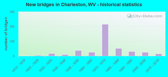
- New bridges - historical statistics
- 21910-1919
- 61920-1929
- 171930-1939
- 111940-1949
- 381950-1959
- 271960-1969
- 2161970-1979
- 531980-1989
- 311990-1999
- 272000-2009
- 162010-2019
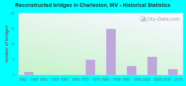
- Reconstructed bridges - Historical Statistics
- 11940-1949
- 01950-1959
- 01960-1969
- 51970-1979
- 151980-1989
- 31990-1999
- 62000-2009
- 22010-2019
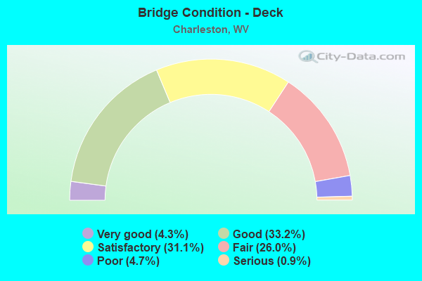
- Bridge Condition - Deck
- 4.3%Very good
- 33.2%Good
- 31.1%Satisfactory
- 26.0%Fair
- 4.7%Poor
- 0.9%Serious
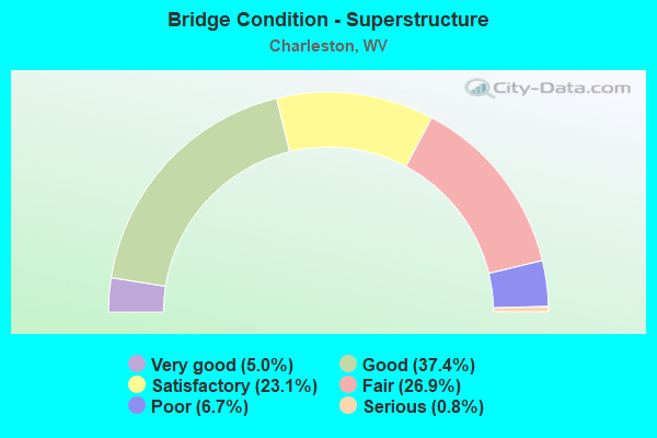
- Bridge Condition - Superstructure
- 5.0%Very good
- 37.4%Good
- 23.1%Satisfactory
- 26.9%Fair
- 6.7%Poor
- 0.8%Serious
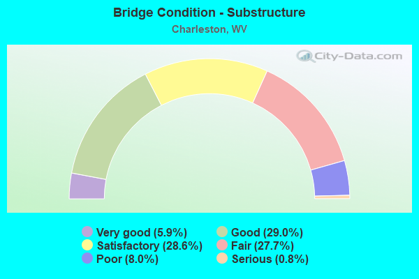
- Bridge Condition - Substructure
- 5.9%Very good
- 29.0%Good
- 28.6%Satisfactory
- 27.7%Fair
- 8.0%Poor
- 0.8%Serious
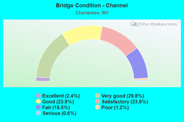
- Bridge Condition - Channel
- 2.4%Excellent
- 29.8%Very good
- 23.8%Good
- 23.8%Satisfactory
- 18.5%Fair
- 1.2%Poor
- 0.6%Serious
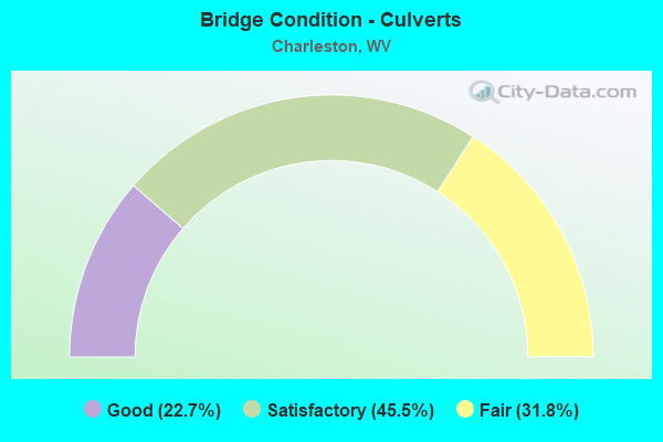
- Bridge Condition - Culverts
- 22.7%Good
- 45.5%Satisfactory
- 31.8%Fair
Find on map >> Show street view
Structure Number: 20A362, Location: 0.42 MI. N. OF WV 61 (Lat: 38.334700, Lng: -81.596861), Route carried "on" structure: Ramp County highway 6062, Year Built: 1975, Status: Open, Structure Length: 12.01m (39.40ft), Average Daily Traffic: 12,465 (year 2016), Truck Traffic: 8%, Average Future Daily Traffic: 15,210 (year 2038), Design Load: HS 20, Features Intersected: I77S,NSRR,CR64/4,CR60/76, Facility Carried by Structure: I-77 NB R CR 60/62
Minimum Vertical Clearance: 30+ m (98+ ft), Kilometerpoint: 0.676, Lanes on structure: 1, Lanes under structure: 4, Owner: State Highway Agency, Approaching Roadway Width: 7.0m (23.0ft), Skew: 2 degrees, Material/Design: Steel continuous, Design/Construction: Stringer/Multi-beam, Number Of Spans In Main Unit: 1, Number Of Approach Spans: 3, Length of Maximum Span: 34.0m (111.5ft), Curb-To-Curb Width: 7.0m (23.0ft), Out-to-Out Width: 8.3m (27.2ft)
Condition: Deck: Fair, Superstructure: Fair, Substructure: Good, Operating Rating: 35.4 metric tons, Method Used To Determine Operating Rating: Load and Resistance Factor (LRFR), Inventory Rating: 27.2 metric tons, Method Used To Determine Inventory Rating: Load and Resistance Factor (LRFR), Structural Evaluation: Somewhat better than minimum adequacy, Deck Geometry: Equal to present minimum criteria, Underclear: High priority of corrective action, Approach Roadway Alignment: Equal to present desirable criteria, Length Of Structure Improvement: 12.01m (39.40ft), Designated Inspection Frequency: Every 24 months, Critical Feature Inspection Frequency: Every 12 months, Other Special Inspection Frequency: Every 12 months, Inspection Date: October 2021, Critical Feature Inspection Date: October 2021, Other Special Inspection Date: October 2021, Bridge Improvement Cost: $450,000, Roadway Improvement Cost: $40,000, Total Project Cost: $490,000 ( Estimate for 2016), Deck Structure Type: Concrete Cast-file-Place, Wearing Surface/Protective System: Wearing Surface: Monolithic Concrete
Find on map >> Show street view
Structure Number: 20A363, Location: 0.06 MI. S. OF US 60 (Lat: 38.334700, Lng: -81.598369), Route carried "on" structure: Ramp County highway 6063, Year Built: 1976, Status: Open, Structure Length: 10.00m (32.81ft), Average Daily Traffic: 15,155 (year 2016), Truck Traffic: 8%, Average Future Daily Traffic: 18,490 (year 2038), Design Load: HS 20+Mod, Features Intersected: CR 60/76, Facility Carried by Structure: CR 60/63
Minimum Vertical Clearance: 30+ m (98+ ft), Kilometerpoint: 0.097, Lanes on structure: 1, Lanes under structure: 1, Owner: State Highway Agency, Approaching Roadway Width: 7.0m (23.0ft), Material/Design: Steel continuous, Design/Construction: Stringer/Multi-beam, Number Of Spans In Main Unit: 2, Number Of Approach Spans: 2, Length of Maximum Span: 27.4m (89.9ft), Curb-To-Curb Width: 7.0m (23.0ft), Out-to-Out Width: 8.3m (27.2ft)
Condition: Deck: Fair, Superstructure: Good, Substructure: Fair, Operating Rating: 38.1 metric tons, Method Used To Determine Operating Rating: Load and Resistance Factor (LRFR), Inventory Rating: 29.0 metric tons, Method Used To Determine Inventory Rating: Load and Resistance Factor (LRFR), Structural Evaluation: Somewhat better than minimum adequacy, Deck Geometry: Equal to present minimum criteria, Underclear: Equal to present minimum criteria, Approach Roadway Alignment: Better than present minimum criteria, Length Of Structure Improvement: 10.00m (32.81ft), Designated Inspection Frequency: Every 24 months, Other Special Inspection Frequency: Every 12 months, Inspection Date: October 2021, Other Special Inspection Date: October 2021, Bridge Improvement Cost: $350,000, Total Project Cost: $350,000 ( Estimate for 2017), Deck Structure Type: Concrete Cast-file-Place, Wearing Surface/Protective System: Wearing Surface: Integral Concrete
Find on map >> Show street view
Structure Number: 20A364, Location: 0.11 MI N OF WV 61 (Lat: 38.332950, Lng: -81.597931), Route carried "on" structure: County highway 6063, Year Built: 1976, Status: Open, Structure Length: 42.18m (138.39ft), Average Daily Traffic: 15,155 (year 2016), Truck Traffic: 8%, Average Future Daily Traffic: 18,490 (year 2038), Design Load: HS 20+Mod, Features Intersected: US 60, KAN RIV, VIR AVE, Facility Carried by Structure: CR 60/63
Minimum Vertical Clearance: 30+ m (98+ ft), Kilometerpoint: 0.177, Lanes on structure: 2, Lanes under structure: 6, Owner: State Highway Agency, Approaching Roadway Width: 9.1m (29.9ft), Navigation Control: Yes ( Vertical Clearance: 20.4m (66.9ft), Horizontal Clearance: 121.9m (399.9ft)), Material/Design: Steel continuous, Design/Construction: Girder and Floorbeam System, Number Of Spans In Main Unit: 1, Number Of Approach Spans: 7, Length of Maximum Span: 126.5m (415.0ft), Curb or Sidewalk Widths: Left: 0.0m, Right: 1.2m (3.9ft), Curb-To-Curb Width: 9.1m (29.9ft), Out-to-Out Width: 11.9m (39.0ft)
Condition: Deck: Fair, Superstructure: Satisfactory, Substructure: Fair, Channel: Very good, Operating Rating: 24.5 metric tons, Method Used To Determine Operating Rating: Load and Resistance Factor (LRFR), Inventory Rating: 19.0 metric tons, Method Used To Determine Inventory Rating: Load and Resistance Factor (LRFR), Structural Evaluation: Meets minimum limits, Deck Geometry: Meets minimum limits, Underclear: Meets minimum limits, Waterway Adequacy: Equal to present desirable criteria, Approach Roadway Alignment: Better than present minimum criteria, Length Of Structure Improvement: 48.34m (158.60ft), Designated Inspection Frequency: Every 24 months, Critical Feature Inspection Frequency: Every 24 months, Underwater Inspection Frequency: Every 60 months, Other Special Inspection Frequency: Every 12 months, Inspection Date: October 2021, Critical Feature Inspection Date: October 2021, Underwater Inspection Date: August 2019, Other Special Inspection Date: October 2021, Bridge Improvement Cost: $500,000, Roadway Improvement Cost: $100,000, Total Project Cost: $600,000, Deck Structure Type: Concrete Cast-file-Place, Wearing Surface/Protective System: Wearing Surface: Integral Concrete
Find on map >> Show street view
Structure Number: 20A374, Location: 0.32 MI N CR 25/25 (Lat: 38.379750, Lng: -81.712231), Route carried "on" structure: State highway 62, Year Built: 1930, Status: Open, Structure Length: 0.81m (2.66ft), Average Daily Traffic: 7,900 (year 2018), Truck Traffic: 6%, Average Future Daily Traffic: 9,638 (year 2038), Features Intersected: TYLER CREEK
Minimum Vertical Clearance: 30+ m (98+ ft), Kilometerpoint: 1.014, Lanes on structure: 2, Owner: State Highway Agency, Approaching Roadway Width: 7.6m (24.9ft), Skew: 3 degrees, Material/Design: Concrete, Design/Construction: Slab, Number Of Spans In Main Unit: 1, Length of Maximum Span: 7.0m (23.0ft), Curb-To-Curb Width: 8.0m (26.2ft), Out-to-Out Width: 8.7m (28.5ft)
Condition: Deck: Poor, Superstructure: Poor, Substructure: Poor, Channel: Satisfactory, Operating Rating: 57.1 metric tons, Method Used To Determine Operating Rating: Field evaluation and documented engineering judgment, Inventory Rating: 25.4 metric tons, Method Used To Determine Inventory Rating: Field evaluation and documented engineering judgment, Structural Evaluation: Meets minimum limits, Deck Geometry: High priority of replacement, Waterway Adequacy: Equal to present minimum criteria, Approach Roadway Alignment: Equal to present desirable criteria, Length Of Structure Improvement: 0.91m (2.99ft), Designated Inspection Frequency: Every 24 months, Inspection Date: September 2020, Bridge Improvement Cost: $450,000, Roadway Improvement Cost: $100,000, Total Project Cost: $550,000 ( Estimate for 2020), Deck Structure Type: Concrete Cast-file-Place, Wearing Surface/Protective System: Wearing Surface: Bituminous
Find on map >> Show street view
Structure Number: 20A391, Location: 0.69 MI E OF US 60 (Lat: 38.358311, Lng: -81.703500), Route carried "on" structure: Interstate 64, Year Built: 1970, Status: Open, Structure Length: 18.88m (61.94ft), Average Daily Traffic: 31,400 (year 2020), Truck Traffic: 17%, Average Future Daily Traffic: 48,984 (year 2040), Design Load: HS 20+Mod, Features Intersected: CR 61/13 AND CSX RR
Minimum Vertical Clearance: 30+ m (98+ ft), Kilometerpoint: 87.500, Lanes on structure: 3, Lanes under structure: 2, Base Highway Network: Yes, Owner: State Highway Agency, Approaching Roadway Width: 17.1m (56.1ft), Material/Design: Steel continuous, Design/Construction: Stringer/Multi-beam, Number Of Spans In Main Unit: 1, Number Of Approach Spans: 4, Length of Maximum Span: 45.1m (148.0ft), Curb-To-Curb Width: 16.5m (54.1ft), Out-to-Out Width: 17.8m (58.4ft)
Condition: Deck: Fair, Superstructure: Fair, Substructure: Fair, Operating Rating: 67.1 metric tons, Method Used To Determine Operating Rating: Load Factor (LF), Inventory Rating: 39.9 metric tons, Method Used To Determine Inventory Rating: Load Factor (LF), Structural Evaluation: Somewhat better than minimum adequacy, Deck Geometry: Equal to present minimum criteria, Underclear: High priority of corrective action, Approach Roadway Alignment: Equal to present desirable criteria, Length Of Structure Improvement: 18.88m (61.94ft), Designated Inspection Frequency: Every 24 months, Inspection Date: November 2021, Deck Structure Type: Concrete Cast-file-Place, Wearing Surface/Protective System: Wearing Surface: Integral Concrete
Find on map >> Show street view
Structure Number: 20A392, Location: 0.69 MI E OF US 60 (Lat: 38.358469, Lng: -81.703519), Route carried "on" structure: Interstate 64, Year Built: 1970, Status: Open, Structure Length: 18.87m (61.91ft), Average Daily Traffic: 31,400 (year 2020), Truck Traffic: 17%, Average Future Daily Traffic: 48,984 (year 2040), Design Load: HS 20+Mod, Features Intersected: KAN TPK & CSX RR
Minimum Vertical Clearance: 30+ m (98+ ft), Kilometerpoint: 87.500, Lanes on structure: 3, Lanes under structure: 1, Base Highway Network: Yes, Owner: State Highway Agency, Approaching Roadway Width: 17.1m (56.1ft), Skew: 10 degrees, Material/Design: Steel continuous, Design/Construction: Stringer/Multi-beam, Number Of Spans In Main Unit: 1, Number Of Approach Spans: 5, Length of Maximum Span: 47.4m (155.5ft), Curb-To-Curb Width: 16.5m (54.1ft), Out-to-Out Width: 17.1m (56.1ft)
Condition: Deck: Fair, Superstructure: Fair, Substructure: Satisfactory, Operating Rating: 63.5 metric tons, Method Used To Determine Operating Rating: Load Factor (LF), Inventory Rating: 38.1 metric tons, Method Used To Determine Inventory Rating: Load Factor (LF), Structural Evaluation: Somewhat better than minimum adequacy, Deck Geometry: Equal to present minimum criteria, Underclear: High priority of corrective action, Approach Roadway Alignment: Equal to present desirable criteria, Length Of Structure Improvement: 18.87m (61.91ft), Designated Inspection Frequency: Every 24 months, Inspection Date: November 2021, Bridge Improvement Cost: $750,000, Total Project Cost: $750,000 ( Estimate for 2019), Deck Structure Type: Concrete Cast-file-Place, Wearing Surface/Protective System: Wearing Surface: Integral Concrete
Find on map >> Show street view
Structure Number: 20A395, Location: 1.57 MI E OF CR 60/64 (Lat: 38.357669, Lng: -81.659031), Route carried "on" structure: Interstate 64, Year Built: 1974, Status: Open, Structure Length: 4.06m (13.32ft), Average Daily Traffic: 62,300 (year 2020), Truck Traffic: 17%, Average Future Daily Traffic: 97,188 (year 2040), Design Load: HS 20+Mod, Features Intersected: CR 61/12
Minimum Vertical Clearance: 30+ m (98+ ft), Kilometerpoint: 91.765, Lanes on structure: 6, Lanes under structure: 2, Base Highway Network: Yes, Owner: State Highway Agency, Approaching Roadway Width: 34.1m (111.9ft), Skew: 30 degrees, Material/Design: Steel continuous, Design/Construction: Stringer/Multi-beam, Number Of Spans In Main Unit: 1, Number Of Approach Spans: 2, Length of Maximum Span: 15.6m (51.2ft), Curb-To-Curb Width: 32.9m (107.9ft), Out-to-Out Width: 34.9m (114.5ft)
Condition: Deck: Very good, Superstructure: Satisfactory, Substructure: Satisfactory, Operating Rating: 64.4 metric tons, Method Used To Determine Operating Rating: Load Factor (LF), Inventory Rating: 38.1 metric tons, Method Used To Determine Inventory Rating: Load Factor (LF), Structural Evaluation: Equal to present minimum criteria, Deck Geometry: Superior to present desirable criteria, Underclear: Equal to present minimum criteria, Approach Roadway Alignment: Equal to present desirable criteria, Length Of Structure Improvement: 4.06m (13.32ft), Designated Inspection Frequency: Every 24 months, Other Special Inspection Frequency: Every 12 months, Inspection Date: September 2021, Other Special Inspection Date: September 2021, Bridge Improvement Cost: $1,200,000, Roadway Improvement Cost: $100,000, Total Project Cost: $1,300,000 ( Estimate for 2019), Deck Structure Type: Concrete Cast-file-Place, Wearing Surface/Protective System: Wearing Surface: Monolithic Concrete
Find on map >> Show street view
Structure Number: 20A397, Location: 2.03 MI E OF CR 60/64 (Lat: 38.355269, Lng: -81.648469), Route carried "on" structure: Interstate 6400, Year Built: 1975, Status: Open, Structure Length: 68.49m (224.70ft), Average Daily Traffic: 132,620 (year 2018), Truck Traffic: 12%, Average Future Daily Traffic: 175,000 (year 2038), Design Load: HS 20+Mod, Features Intersected: KAN R WV61 CSX RR US119, Facility Carried by Structure: I-64 E & W
Minimum Vertical Clearance: 5.11m (16.77ft), Kilometerpoint: 92.505, Lanes on structure: 8, Lanes under structure: 1, Base Highway Network: Yes, Owner: State Highway Agency, Approaching Roadway Width: 32.0m (105.0ft), Skew: 10 degrees, Navigation Control: Yes ( Vertical Clearance: 27.1m (88.9ft), Horizontal Clearance: 121.9m (399.9ft)), Material/Design: Steel, Design/Construction: Truss - Thru, Number Of Spans In Main Unit: 1, Number Of Approach Spans: 16, Length of Maximum Span: 141.7m (464.9ft), Curb-To-Curb Width: 32.0m (105.0ft), Out-to-Out Width: 34.5m (113.2ft)
Condition: Deck: Fair, Superstructure: Fair, Substructure: Satisfactory, Channel: Very good, Operating Rating: 64.4 metric tons, Method Used To Determine Operating Rating: Load Factor (LF), Inventory Rating: 32.7 metric tons, Method Used To Determine Inventory Rating: Load Factor (LF), Structural Evaluation: Somewhat better than minimum adequacy, Deck Geometry: Meets minimum limits, Underclear: Somewhat better than minimum adequacy, Waterway Adequacy: Superior to present desirable criteria, Approach Roadway Alignment: Equal to present desirable criteria, Length Of Structure Improvement: 68.49m (224.70ft), Designated Inspection Frequency: Every 24 months, Critical Feature Inspection Frequency: Every 12 months, Underwater Inspection Frequency: Every 60 months, Other Special Inspection Frequency: Every 12 months, Inspection Date: October 2020, Critical Feature Inspection Date: October 2021, Underwater Inspection Date: August 2019, Other Special Inspection Date: October 2021, Bridge Improvement Cost: $7,000,000, Roadway Improvement Cost: $500,000, Total Project Cost: $7,500,000, Deck Structure Type: Concrete Cast-file-Place, Wearing Surface/Protective System: Wearing Surface: Latex Concrete
Find on map >> Show street view
Structure Number: 20A398, Location: 2.15 MI E OF CR 60/64 (Lat: 38.354861, Lng: -81.650719), Route carried "on" structure: Ramp Interstate 64, Year Built: 1975, Status: Open, Structure Length: 23.51m (77.13ft), Average Daily Traffic: 10,551 (year 2017), Truck Traffic: 17%, Average Future Daily Traffic: 14,877 (year 2037), Design Load: HS 20+Mod, Features Intersected: I64 WV61 KAN R CSX RR
Minimum Vertical Clearance: 30+ m (98+ ft), Kilometerpoint: 92.698, Lanes on structure: 1, Lanes under structure: 4, Owner: State Highway Agency, Approaching Roadway Width: 7.6m (24.9ft), Material/Design: Steel continuous, Design/Construction: Stringer/Multi-beam, Number Of Spans In Main Unit: 1, Number Of Approach Spans: 7, Length of Maximum Span: 47.2m (154.9ft), Curb-To-Curb Width: 6.9m (22.6ft), Out-to-Out Width: 8.0m (26.2ft)
Condition: Deck: Satisfactory, Superstructure: Good, Substructure: Fair, Channel: Very good, Operating Rating: 72.6 metric tons, Method Used To Determine Operating Rating: Load Factor (LF), Inventory Rating: 43.5 metric tons, Method Used To Determine Inventory Rating: Load Factor (LF), Structural Evaluation: Somewhat better than minimum adequacy, Deck Geometry: Equal to present minimum criteria, Underclear: Equal to present minimum criteria, Waterway Adequacy: Superior to present desirable criteria, Approach Roadway Alignment: Equal to present desirable criteria, Designated Inspection Frequency: Every 24 months, Underwater Inspection Frequency: Every 60 months, Other Special Inspection Frequency: Every 12 months, Inspection Date: October 2020, Underwater Inspection Date: August 2019, Other Special Inspection Date: October 2021, Deck Structure Type: Concrete Cast-file-Place, Wearing Surface/Protective System: Wearing Surface: Latex Concrete
Find on map >> Show street view
Structure Number: 20A399, Location: 0.26 MI E OF US 119 (Lat: 38.356581, Lng: -81.646661), Route carried "on" structure: Ramp Interstate 64, Year Built: 1975, Status: Open, Structure Length: 13.76m (45.14ft), Average Daily Traffic: 7,095 (year 2018), Truck Traffic: 17%, Average Future Daily Traffic: 10,005 (year 2038), Design Load: HS 20+Mod, Features Intersected: KANAWHA BOULEVARD
Minimum Vertical Clearance: 30+ m (98+ ft), Kilometerpoint: 92.924, Lanes on structure: 1, Lanes under structure: 4, Owner: State Highway Agency, Approaching Roadway Width: 7.3m (24.0ft), Material/Design: Steel continuous, Design/Construction: Girder and Floorbeam System, Number Of Spans In Main Unit: 1, Number Of Approach Spans: 4, Length of Maximum Span: 36.3m (119.1ft), Curb-To-Curb Width: 6.9m (22.6ft), Out-to-Out Width: 8.0m (26.2ft)
Condition: Deck: Fair, Superstructure: Good, Substructure: Fair, Channel: Very good, Operating Rating: 60.8 metric tons, Method Used To Determine Operating Rating: Load Factor (LF), Inventory Rating: 36.3 metric tons, Method Used To Determine Inventory Rating: Load Factor (LF), Structural Evaluation: Somewhat better than minimum adequacy, Deck Geometry: Equal to present minimum criteria, Underclear: Meets minimum limits, Waterway Adequacy: Superior to present desirable criteria, Approach Roadway Alignment: Equal to present desirable criteria, Designated Inspection Frequency: Every 24 months, Critical Feature Inspection Frequency: Every 24 months, Inspection Date: October 2020, Critical Feature Inspection Date: October 2020, Deck Structure Type: Concrete Cast-file-Place, Wearing Surface/Protective System: Wearing Surface: Latex Concrete
Find on map >> Show street view
Structure Number: 20A4, Location: 0.29 MI E OF US 119 (Lat: 38.356181, Lng: -81.645889), Route carried "on" structure: Ramp Interstate 64, Year Built: 1975, Status: Open, Structure Length: 13.75m (45.11ft), Average Daily Traffic: 7,083 (year 2017), Truck Traffic: 17%, Average Future Daily Traffic: 9,987 (year 2037), Design Load: HS 20+Mod, Features Intersected: KANAWHA BLVD & PENN AVE
Minimum Vertical Clearance: 30+ m (98+ ft), Kilometerpoint: 92.972, Lanes on structure: 1, Lanes under structure: 1, Owner: State Highway Agency, Approaching Roadway Width: 7.3m (24.0ft), Material/Design: Steel continuous, Design/Construction: Girder and Floorbeam System, Number Of Spans In Main Unit: 1, Number Of Approach Spans: 4, Length of Maximum Span: 35.9m (117.8ft), Curb-To-Curb Width: 6.9m (22.6ft), Out-to-Out Width: 8.0m (26.2ft)
Condition: Deck: Satisfactory, Superstructure: Good, Substructure: Good, Channel: Very good, Operating Rating: 68.9 metric tons, Method Used To Determine Operating Rating: Load Factor (LF), Inventory Rating: 40.8 metric tons, Method Used To Determine Inventory Rating: Load Factor (LF), Structural Evaluation: Better than present minimum criteria, Deck Geometry: Equal to present minimum criteria, Underclear: Superior to present desirable criteria, Approach Roadway Alignment: Equal to present desirable criteria, Designated Inspection Frequency: Every 24 months, Critical Feature Inspection Frequency: Every 24 months, Inspection Date: October 2020, Critical Feature Inspection Date: October 2020, Deck Structure Type: Concrete Cast-file-Place, Wearing Surface/Protective System: Wearing Surface: Monolithic Concrete
Find on map >> Show street view
Structure Number: 20A401, Location: 0.42 MI E OF US 119 (Lat: 38.358261, Lng: -81.642581), Route carried "on" structure: Interstate 64, Year Built: 1975, Status: Open, Structure Length: 53.23m (174.64ft), Average Daily Traffic: 99,696 (year 2016), Truck Traffic: 21%, Average Future Daily Traffic: 148,390 (year 2038), Design Load: HS 20+Mod, Features Intersected: VA,RANDLPH,LEE& WASH STS
Minimum Vertical Clearance: 30+ m (98+ ft), Kilometerpoint: 93.181, Lanes on structure: 6, Lanes under structure: 3, Owner: State Highway Agency, Approaching Roadway Width: 34.7m (113.8ft), Material/Design: Concrete continuous, Design/Construction: Box Beam or Girders - Single/Spread, Number Of Spans In Main Unit: 3, Number Of Approach Spans: 17, Length of Maximum Span: 281.1m (922.2ft), Curb-To-Curb Width: 32.9m (107.9ft), Out-to-Out Width: 34.9m (114.5ft)
Condition: Deck: Good, Superstructure: Fair, Substructure: Satisfactory, Operating Rating: 88.9 metric tons, Method Used To Determine Operating Rating: Load Factor (LF), Inventory Rating: 55.3 metric tons, Method Used To Determine Inventory Rating: Load Factor (LF), Structural Evaluation: Somewhat better than minimum adequacy, Deck Geometry: Superior to present desirable criteria, Underclear: Equal to present minimum criteria, Approach Roadway Alignment: Equal to present desirable criteria, Length Of Structure Improvement: 53.23m (174.64ft), Designated Inspection Frequency: Every 24 months, Inspection Date: Febuary 2022, Bridge Improvement Cost: $550,000, Roadway Improvement Cost: $100,000, Total Project Cost: $650,000 ( Estimate for 2020), Deck Structure Type: Concrete Cast-file-Place, Wearing Surface/Protective System: Wearing Surface: Epoxy Overlay, Deck Protection: Cathodic Protection
Find on map >> Show street view
Structure Number: 20A403, Location: 0.48 MI E OF US 119 (Lat: 38.357550, Lng: -81.643800), Route carried "on" structure: Ramp Interstate 64, Year Built: 1975, Status: Open, Structure Length: 12.90m (42.32ft), Average Daily Traffic: 5,700 (year 2020), Truck Traffic: 17%, Average Future Daily Traffic: 8,892 (year 2040), Design Load: HS 20+Mod, Features Intersected: CHAS CITY PARKING LOTS
Minimum Vertical Clearance: 30+ m (98+ ft), Kilometerpoint: 93.278, Lanes on structure: 1, Owner: State Highway Agency, Approaching Roadway Width: 7.3m (24.0ft), Material/Design: Concrete continuous, Design/Construction: Box Beam or Girders - Multiple, Number Of Spans In Main Unit: 5, Length of Maximum Span: 25.6m (84.0ft), Curb-To-Curb Width: 7.2m (23.6ft), Out-to-Out Width: 8.3m (27.2ft)
Condition: Deck: Good, Superstructure: Fair, Substructure: Fair, Operating Rating: 63.5 metric tons, Method Used To Determine Operating Rating: Load Factor (LF), Inventory Rating: 24.5 metric tons, Method Used To Determine Inventory Rating: Load Factor (LF), Structural Evaluation: Somewhat better than minimum adequacy, Deck Geometry: Equal to present minimum criteria, Approach Roadway Alignment: Equal to present desirable criteria, Length Of Structure Improvement: 12.90m (42.32ft), Designated Inspection Frequency: Every 24 months, Inspection Date: December 2021, Bridge Improvement Cost: $1,000,000, Roadway Improvement Cost: $100,000, Total Project Cost: $1,100,000 ( Estimate for 2019), Deck Structure Type: Concrete Cast-file-Place, Wearing Surface/Protective System: Wearing Surface: Monolithic Concrete, Deck Protection: Cathodic Protection
Find on map >> Show street view
Structure Number: 20A404, Location: 0.52 MI E OF US 119 (Lat: 38.358019, Lng: -81.643581), Route carried "on" structure: Ramp Interstate 64, Year Built: 1975, Status: Open, Structure Length: 11.62m (38.12ft), Average Daily Traffic: 6,078 (year 2020), Truck Traffic: 17%, Average Future Daily Traffic: 9,482 (year 2040), Design Load: HS 20+Mod, Features Intersected: CITY PARKING LOT
Minimum Vertical Clearance: 30+ m (98+ ft), Kilometerpoint: 93.342, Lanes on structure: 1, Owner: State Highway Agency, Approaching Roadway Width: 7.3m (24.0ft), Material/Design: Concrete continuous, Design/Construction: Box Beam or Girders - Multiple, Number Of Spans In Main Unit: 5, Length of Maximum Span: 25.6m (84.0ft), Curb-To-Curb Width: 7.2m (23.6ft), Out-to-Out Width: 8.4m (27.6ft)
Condition: Deck: Good, Superstructure: Fair, Substructure: Fair, Operating Rating: 63.5 metric tons, Method Used To Determine Operating Rating: Load Factor (LF), Inventory Rating: 24.5 metric tons, Method Used To Determine Inventory Rating: Load Factor (LF), Structural Evaluation: Somewhat better than minimum adequacy, Deck Geometry: Equal to present minimum criteria, Approach Roadway Alignment: Equal to present desirable criteria, Length Of Structure Improvement: 11.62m (38.12ft), Designated Inspection Frequency: Every 24 months, Inspection Date: December 2021, Bridge Improvement Cost: $750,000, Roadway Improvement Cost: $100,000, Total Project Cost: $850,000 ( Estimate for 2019), Deck Structure Type: Concrete Cast-file-Place, Wearing Surface/Protective System: Wearing Surface: Monolithic Concrete, Deck Protection: Cathodic Protection
Find on map >> Show street view
Structure Number: 20A405, Location: 0.36 MI E OF US 60 (Lat: 38.360089, Lng: -81.632739), Route carried "on" structure: Interstate 64, Year Built: 1975, Status: Open, Structure Length: 47.55m (156.00ft), Average Daily Traffic: 42,345 (year 2014), Truck Traffic: 17%, Average Future Daily Traffic: 74,104 (year 2034), Design Load: HS 20+Mod, Features Intersected: I-64 WB, US119 S, N&S RR
Minimum Vertical Clearance: 5.13m (16.83ft), Kilometerpoint: 94.324, Lanes on structure: 3, Lanes under structure: 6, Base Highway Network: Yes, Owner: State Highway Agency, Approaching Roadway Width: 16.2m (53.1ft), Material/Design: Steel continuous, Design/Construction: Box Beam or Girders - Multiple, Number Of Spans In Main Unit: 1, Number Of Approach Spans: 10, Length of Maximum Span: 59.4m (194.9ft), Curb-To-Curb Width: 16.0m (52.5ft), Out-to-Out Width: 17.1m (56.1ft)
Condition: Deck: Good, Superstructure: Fair, Substructure: Satisfactory, Operating Rating: 48.1 metric tons, Method Used To Determine Operating Rating: Load and Resistance Factor (LRFR), Inventory Rating: 37.2 metric tons, Method Used To Determine Inventory Rating: Load and Resistance Factor (LRFR), Structural Evaluation: Somewhat better than minimum adequacy, Deck Geometry: Somewhat better than minimum adequacy, Underclear: High priority of corrective action, Approach Roadway Alignment: Equal to present desirable criteria, Designated Inspection Frequency: Every 24 months, Other Special Inspection Frequency: Every 12 months, Inspection Date: December 2019, Other Special Inspection Date: December 2020, Deck Structure Type: Concrete Cast-file-Place, Wearing Surface/Protective System: Wearing Surface: Latex Concrete
Find on map >> Show street view
Structure Number: 20A406, Location: 0.46 MILES EAST OF US 60 (Lat: 38.359519, Lng: -81.633169), Route carried "on" structure: Interstate 64, Year Built: 1975, Status: Open, Structure Length: 24.88m (81.63ft), Average Daily Traffic: 42,345 (year 2014), Truck Traffic: 17%, Average Future Daily Traffic: 74,104 (year 2034), Design Load: HS 20+Mod, Features Intersected: US119 N
Minimum Vertical Clearance: 30+ m (98+ ft), Kilometerpoint: 94.485, Lanes on structure: 2, Lanes under structure: 2, Base Highway Network: Yes, Owner: State Highway Agency, Approaching Roadway Width: 12.5m (41.0ft), Material/Design: Steel continuous, Design/Construction: Box Beam or Girders - Multiple, Number Of Spans In Main Unit: 1, Number Of Approach Spans: 3, Length of Maximum Span: 75.6m (248.0ft), Curb-To-Curb Width: 12.3m (40.4ft), Out-to-Out Width: 13.5m (44.3ft)
Condition: Deck: Good, Superstructure: Fair, Substructure: Good, Operating Rating: 41.7 metric tons, Method Used To Determine Operating Rating: Load and Resistance Factor (LRFR), Inventory Rating: 32.7 metric tons, Method Used To Determine Inventory Rating: Load and Resistance Factor (LRFR), Structural Evaluation: Somewhat better than minimum adequacy, Deck Geometry: Better than present minimum criteria, Underclear: Equal to present minimum criteria, Approach Roadway Alignment: Equal to present desirable criteria, Designated Inspection Frequency: Every 24 months, Critical Feature Inspection Frequency: Every 24 months, Other Special Inspection Frequency: Every 12 months, Inspection Date: December 2019, Critical Feature Inspection Date: December 2019, Other Special Inspection Date: December 2020, Deck Structure Type: Concrete Cast-file-Place, Wearing Surface/Protective System: Wearing Surface: Latex Concrete
Find on map >> Show street view
Structure Number: 20A407, Location: 0.36 MI E OF US 60 (Lat: 38.360231, Lng: -81.633011), Route carried "on" structure: Interstate 64, Year Built: 1975, Status: Open, Structure Length: 44.62m (146.39ft), Average Daily Traffic: 42,345 (year 2014), Truck Traffic: 17%, Average Future Daily Traffic: 74,104 (year 2034), Design Load: HS 20+Mod, Features Intersected: I-64 WB, US119 S, N&S RR
Minimum Vertical Clearance: 30+ m (98+ ft), Kilometerpoint: 94.324, Lanes on structure: 2, Lanes under structure: 6, Base Highway Network: Yes, Owner: State Highway Agency, Approaching Roadway Width: 12.8m (42.0ft), Material/Design: Steel continuous, Design/Construction: Box Beam or Girders - Multiple, Number Of Spans In Main Unit: 2, Number Of Approach Spans: 9, Length of Maximum Span: 51.8m (169.9ft), Curb-To-Curb Width: 12.3m (40.4ft), Out-to-Out Width: 13.6m (44.6ft)
Condition: Deck: Good, Superstructure: Satisfactory, Substructure: Satisfactory, Operating Rating: 44.4 metric tons, Method Used To Determine Operating Rating: Load and Resistance Factor (LRFR), Inventory Rating: 34.5 metric tons, Method Used To Determine Inventory Rating: Load and Resistance Factor (LRFR), Structural Evaluation: Equal to present minimum criteria, Deck Geometry: Better than present minimum criteria, Underclear: High priority of corrective action, Approach Roadway Alignment: Equal to present desirable criteria, Designated Inspection Frequency: Every 24 months, Critical Feature Inspection Frequency: Every 24 months, Other Special Inspection Frequency: Every 24 months, Inspection Date: December 2019, Critical Feature Inspection Date: December 2019, Other Special Inspection Date: December 2019, Deck Structure Type: Concrete Cast-file-Place, Wearing Surface/Protective System: Wearing Surface: Latex Concrete
Find on map >> Show street view
Structure Number: 20A408, Location: 0.46 MILES EAST OF US 60 (Lat: 38.359500, Lng: -81.632431), Route carried "on" structure: Interstate 64, Year Built: 1975, Status: Open, Structure Length: 28.25m (92.68ft), Average Daily Traffic: 42,345 (year 2014), Truck Traffic: 17%, Average Future Daily Traffic: 74,104 (year 2034), Design Load: HS 20+Mod, Features Intersected: I-64W,I-64E,US119N,I-77N
Minimum Vertical Clearance: 5.16m (16.93ft), Kilometerpoint: 94.501, Lanes on structure: 2, Lanes under structure: 2, Base Highway Network: Yes, Owner: State Highway Agency, Approaching Roadway Width: 12.8m (42.0ft), Material/Design: Steel continuous, Design/Construction: Box Beam or Girders - Multiple, Number Of Spans In Main Unit: 1, Number Of Approach Spans: 7, Length of Maximum Span: 49.2m (161.4ft), Curb-To-Curb Width: 12.3m (40.4ft), Out-to-Out Width: 13.5m (44.3ft)
Condition: Deck: Satisfactory, Superstructure: Satisfactory, Substructure: Satisfactory, Operating Rating: 29.0 metric tons, Method Used To Determine Operating Rating: Load and Resistance Factor (LRFR), Inventory Rating: 22.7 metric tons, Method Used To Determine Inventory Rating: Load and Resistance Factor (LRFR), Structural Evaluation: Somewhat better than minimum adequacy, Deck Geometry: Somewhat better than minimum adequacy, Underclear: Equal to present minimum criteria, Approach Roadway Alignment: Equal to present desirable criteria, Designated Inspection Frequency: Every 24 months, Critical Feature Inspection Frequency: Every 24 months, Other Special Inspection Frequency: Every 24 months, Inspection Date: December 2019, Critical Feature Inspection Date: December 2019, Other Special Inspection Date: December 2019, Deck Structure Type: Concrete Cast-file-Place, Wearing Surface/Protective System: Wearing Surface: Latex Concrete
Find on map >> Show street view
Structure Number: 20A409, Location: 1.16 MI N OF WV 114 (Lat: 38.353450, Lng: -81.628500), Route carried "on" structure: Interstate 77, Year Built: 1975, Status: Open, Structure Length: 43.50m (142.72ft), Average Daily Traffic: 40,862 (year 2014), Truck Traffic: 17%, Average Future Daily Traffic: 71,508 (year 2034), Design Load: HS 20+Mod, Features Intersected: PIEDMONT RD & SMITH ST
Minimum Vertical Clearance: 5.36m (17.59ft), Kilometerpoint: 161.385, Lanes on structure: 4, Lanes under structure: 6, Base Highway Network: Yes, Owner: State Highway Agency, Approaching Roadway Width: 20.4m (66.9ft), Material/Design: Steel continuous, Design/Construction: Box Beam or Girders - Multiple, Number Of Spans In Main Unit: 1, Number Of Approach Spans: 14, Length of Maximum Span: 41.5m (136.2ft), Curb-To-Curb Width: 16.0m (52.5ft), Out-to-Out Width: 17.1m (56.1ft)
Condition: Deck: Good, Superstructure: Fair, Substructure: Fair, Operating Rating: 36.3 metric tons, Method Used To Determine Operating Rating: Load and Resistance Factor (LRFR), Inventory Rating: 28.1 metric tons, Method Used To Determine Inventory Rating: Load and Resistance Factor (LRFR), Structural Evaluation: Somewhat better than minimum adequacy, Deck Geometry: Meets minimum limits, Underclear: Meets minimum limits, Approach Roadway Alignment: Equal to present desirable criteria, Designated Inspection Frequency: Every 24 months, Critical Feature Inspection Frequency: Every 24 months, Other Special Inspection Frequency: Every 12 months, Inspection Date: December 2019, Critical Feature Inspection Date: December 2019, Other Special Inspection Date: December 2020, Deck Structure Type: Concrete Cast-file-Place, Wearing Surface/Protective System: Wearing Surface: Latex Concrete
Find on map >> Show street view
Structure Number: 20A41, Location: 1.14 MI N OF WV 114 (Lat: 38.353219, Lng: -81.628331), Route carried "on" structure: Interstate 77, Year Built: 1975, Status: Open, Structure Length: 49.83m (163.48ft), Average Daily Traffic: 40,862 (year 2014), Truck Traffic: 17%, Average Future Daily Traffic: 71,508 (year 2034), Design Load: HS 20+Mod, Features Intersected: PIEDMONT RD & SMITH ST
Minimum Vertical Clearance: 5.46m (17.91ft), Kilometerpoint: 161.353, Lanes on structure: 4, Lanes under structure: 6, Base Highway Network: Yes, Owner: State Highway Agency, Approaching Roadway Width: 16.5m (54.1ft), Material/Design: Steel continuous, Design/Construction: Box Beam or Girders - Multiple, Number Of Spans In Main Unit: 1, Number Of Approach Spans: 14, Length of Maximum Span: 44.2m (145.0ft), Curb-To-Curb Width: 16.0m (52.5ft), Out-to-Out Width: 17.2m (56.4ft)
Condition: Deck: Good, Superstructure: Fair, Substructure: Fair, Operating Rating: 41.7 metric tons, Method Used To Determine Operating Rating: Load and Resistance Factor (LRFR), Inventory Rating: 31.7 metric tons, Method Used To Determine Inventory Rating: Load and Resistance Factor (LRFR), Structural Evaluation: Somewhat better than minimum adequacy, Deck Geometry: Meets minimum limits, Underclear: Meets minimum limits, Approach Roadway Alignment: Equal to present desirable criteria, Designated Inspection Frequency: Every 24 months, Critical Feature Inspection Frequency: Every 24 months, Other Special Inspection Frequency: Every 12 months, Inspection Date: December 2019, Critical Feature Inspection Date: December 2019, Other Special Inspection Date: December 2020, Deck Structure Type: Concrete Cast-file-Place, Wearing Surface/Protective System: Wearing Surface: Latex Concrete
Find on map >> Show street view
Structure Number: 20A411, Location: 1.14 MI N OF WV 114 (Lat: 38.352231, Lng: -81.626669), Route carried "on" structure: Ramp Interstate 7700, Year Built: 1975, Status: Open, Structure Length: 16.37m (53.71ft), Average Daily Traffic: 12,662 (year 2016), Truck Traffic: 18%, Average Future Daily Traffic: 13,928 (year 2036), Design Load: HS 20+Mod, Features Intersected: PIEDMONT L SULLIVAN KNWA, Facility Carried by Structure: I-77 RAMP E
Minimum Vertical Clearance: 30+ m (98+ ft), Kilometerpoint: 161.369, Lanes on structure: 1, Lanes under structure: 3, Owner: State Highway Agency, Approaching Roadway Width: 10.1m (33.1ft), Material/Design: Steel continuous, Design/Construction: Box Beam or Girders - Multiple, Number Of Spans In Main Unit: 1, Number Of Approach Spans: 6, Length of Maximum Span: 29.4m (96.5ft), Curb-To-Curb Width: 9.3m (30.5ft), Out-to-Out Width: 10.5m (34.4ft)
Condition: Deck: Satisfactory, Superstructure: Fair, Substructure: Satisfactory, Operating Rating: 59.9 metric tons, Method Used To Determine Operating Rating: Allowable Stress (AS), Inventory Rating: 34.5 metric tons, Method Used To Determine Inventory Rating: Allowable Stress (AS), Structural Evaluation: Somewhat better than minimum adequacy, Deck Geometry: Superior to present desirable criteria, Underclear: Somewhat better than minimum adequacy, Approach Roadway Alignment: Equal to present desirable criteria, Designated Inspection Frequency: Every 24 months, Critical Feature Inspection Frequency: Every 12 months, Other Special Inspection Frequency: Every 12 months, Inspection Date: May 2020, Critical Feature Inspection Date: May 2021, Other Special Inspection Date: May 2021, Deck Structure Type: Concrete Cast-file-Place, Wearing Surface/Protective System: Wearing Surface: Latex Concrete
Find on map >> Show street view
Structure Number: 20A412, Location: 1.04 MI N OF WV 114 (Lat: 38.352181, Lng: -81.625731), Route carried "on" structure: Ramp Interstate 7700, Year Built: 1975, Status: Open, Structure Length: 41.15m (135.01ft), Average Daily Traffic: 6,733 (year 2016), Truck Traffic: 17%, Average Future Daily Traffic: 7,406 (year 2036), Design Load: HS 20+Mod, Features Intersected: I77 RAMP G PIEDMONT SMIT, Facility Carried by Structure: I-77 RAMP F
Minimum Vertical Clearance: 5.26m (17.26ft), Kilometerpoint: 161.192, Lanes on structure: 1, Lanes under structure: 11, Owner: State Highway Agency, Approaching Roadway Width: 7.3m (24.0ft), Material/Design: Steel continuous, Design/Construction: Box Beam or Girders - Multiple, Number Of Spans In Main Unit: 1, Number Of Approach Spans: 11, Length of Maximum Span: 47.7m (156.5ft), Curb-To-Curb Width: 6.2m (20.3ft), Out-to-Out Width: 7.5m (24.6ft)
Condition: Deck: Satisfactory, Superstructure: Fair, Substructure: Satisfactory, Operating Rating: 64.4 metric tons, Method Used To Determine Operating Rating: Allowable Stress (AS), Inventory Rating: 34.5 metric tons, Method Used To Determine Inventory Rating: Allowable Stress (AS), Structural Evaluation: Somewhat better than minimum adequacy, Deck Geometry: Somewhat better than minimum adequacy, Underclear: High priority of corrective action, Approach Roadway Alignment: Equal to present minimum criteria, Designated Inspection Frequency: Every 24 months, Critical Feature Inspection Frequency: Every 12 months, Other Special Inspection Frequency: Every 12 months, Inspection Date: May 2020, Critical Feature Inspection Date: May 2021, Other Special Inspection Date: May 2021, Deck Structure Type: Concrete Cast-file-Place, Wearing Surface/Protective System: Wearing Surface: Latex Concrete
Find on map >> Show street view
Structure Number: 20A413, Location: 1.52 MI E OF US 60 (Lat: 38.351950, Lng: -81.623511), Route carried "on" structure: Ramp Interstate 7700, Year Built: 1975, Status: Open, Structure Length: 16.04m (52.62ft), Average Daily Traffic: 4,796 (year 2017), Truck Traffic: 17%, Average Future Daily Traffic: 5,276 (year 2037), Design Load: HS 20+Mod, Features Intersected: I-77, PIEDMONT RD, Facility Carried by Structure: BROOK ST I-77 RAMP
Minimum Vertical Clearance: 30+ m (98+ ft), Kilometerpoint: 161.128, Lanes on structure: 1, Lanes under structure: 8, Owner: State Highway Agency, Approaching Roadway Width: 6.7m (22.0ft), Material/Design: Steel continuous, Design/Construction: Box Beam or Girders - Single/Spread, Number Of Spans In Main Unit: 1, Number Of Approach Spans: 3, Length of Maximum Span: 53.0m (173.9ft), Curb-To-Curb Width: 6.6m (21.7ft), Out-to-Out Width: 7.8m (25.6ft)
Condition: Deck: Satisfactory, Superstructure: Fair, Substructure: Satisfactory, Operating Rating: 63.5 metric tons, Method Used To Determine Operating Rating: Allowable Stress (AS), Inventory Rating: 32.7 metric tons, Method Used To Determine Inventory Rating: Allowable Stress (AS), Structural Evaluation: Somewhat better than minimum adequacy, Deck Geometry: Somewhat better than minimum adequacy, Underclear: Somewhat better than minimum adequacy, Approach Roadway Alignment: Better than present minimum criteria, Designated Inspection Frequency: Every 24 months, Critical Feature Inspection Frequency: Every 12 months, Other Special Inspection Frequency: Every 12 months, Inspection Date: May 2020, Critical Feature Inspection Date: May 2021, Other Special Inspection Date: May 2021, Deck Structure Type: Concrete Cast-file-Place, Wearing Surface/Protective System: Wearing Surface: Latex Concrete
Find on map >> Show street view
Structure Number: 20A414, Location: 1.57 MI E OF US 60 (Lat: 38.350619, Lng: -81.624481), Route carried "on" structure: Ramp Interstate 7700, Year Built: 1975, Status: Open, Structure Length: 25.13m (82.45ft), Average Daily Traffic: 8,869 (year 2017), Truck Traffic: 21%, Average Future Daily Traffic: 9,756 (year 2037), Design Load: HS 20+Mod, Features Intersected: BROOKS & SMITH ST & KNWA, Facility Carried by Structure: BROOKS ST RAMP GH
Minimum Vertical Clearance: 30+ m (98+ ft), Kilometerpoint: 161.047, Lanes on structure: 1, Lanes under structure: 4, Owner: State Highway Agency, Approaching Roadway Width: 6.4m (21.0ft), Material/Design: Steel continuous, Design/Construction: Box Beam or Girders - Single/Spread, Number Of Spans In Main Unit: 1, Number Of Approach Spans: 6, Length of Maximum Span: 43.6m (143.0ft), Curb-To-Curb Width: 6.2m (20.3ft), Out-to-Out Width: 7.5m (24.6ft)
Condition: Deck: Satisfactory, Superstructure: Fair, Substructure: Satisfactory, Operating Rating: 63.5 metric tons, Method Used To Determine Operating Rating: Allowable Stress (AS), Inventory Rating: 37.2 metric tons, Method Used To Determine Inventory Rating: Allowable Stress (AS), Structural Evaluation: Somewhat better than minimum adequacy, Deck Geometry: Somewhat better than minimum adequacy, Underclear: Superior to present desirable criteria, Approach Roadway Alignment: Equal to present desirable criteria, Designated Inspection Frequency: Every 24 months, Critical Feature Inspection Frequency: Every 12 months, Other Special Inspection Frequency: Every 12 months, Inspection Date: May 2020, Critical Feature Inspection Date: May 2021, Other Special Inspection Date: May 2021, Deck Structure Type: Concrete Cast-file-Place, Wearing Surface/Protective System: Wearing Surface: Latex Concrete
Find on map >> Show street view
Structure Number: 20A415, Location: 0.86 MI N OF WV 114 (Lat: 38.351319, Lng: -81.622839), Route carried "on" structure: Ramp Interstate 7700, Year Built: 1975, Status: Open, Structure Length: 14.32m (46.98ft), Average Daily Traffic: 4,073 (year 2017), Truck Traffic: 17%, Average Future Daily Traffic: 4,480 (year 2037), Design Load: HS 20+Mod, Features Intersected: PIEDMONT ROAD, Facility Carried by Structure: I-77 RAMP H SOUTH
Minimum Vertical Clearance: 30+ m (98+ ft), Kilometerpoint: 160.902, Lanes on structure: 1, Lanes under structure: 2, Owner: State Highway Agency, Approaching Roadway Width: 6.1m (20.0ft), Material/Design: Steel continuous, Design/Construction: Box Beam or Girders - Single/Spread, Number Of Spans In Main Unit: 1, Number Of Approach Spans: 3, Length of Maximum Span: 49.3m (161.7ft), Curb-To-Curb Width: 6.6m (21.7ft), Out-to-Out Width: 7.8m (25.6ft)
Condition: Deck: Satisfactory, Superstructure: Satisfactory, Substructure: Satisfactory, Operating Rating: 88.0 metric tons, Method Used To Determine Operating Rating: Allowable Stress (AS), Inventory Rating: 32.7 metric tons, Method Used To Determine Inventory Rating: Allowable Stress (AS), Structural Evaluation: Equal to present minimum criteria, Deck Geometry: Somewhat better than minimum adequacy, Underclear: High priority of corrective action, Approach Roadway Alignment: Better than present minimum criteria, Designated Inspection Frequency: Every 24 months, Critical Feature Inspection Frequency: Every 12 months, Other Special Inspection Frequency: Every 12 months, Inspection Date: May 2020, Critical Feature Inspection Date: May 2021, Other Special Inspection Date: May 2021, Roadway Improvement Cost: $10,000, Total Project Cost: $10,000 ( Estimate for 2021), Deck Structure Type: Concrete Cast-file-Place, Wearing Surface/Protective System: Wearing Surface: Latex Concrete
Find on map >> Show street view
Structure Number: 20A416, Location: 0.35 MI N OF WV 114 (Lat: 38.346400, Lng: -81.615189), Route carried "on" structure: Interstate 77, Year Built: 1975, Status: Open, Structure Length: 3.77m (12.37ft), Average Daily Traffic: 71,400 (year 2020), Truck Traffic: 17%, Average Future Daily Traffic: 111,384 (year 2040), Design Load: HS 20+Mod, Features Intersected: STADIUM PLACE
Minimum Vertical Clearance: 30+ m (98+ ft), Kilometerpoint: 160.065, Lanes on structure: 6, Lanes under structure: 2, Base Highway Network: Yes, Owner: State Highway Agency, Approaching Roadway Width: 32.9m (107.9ft), Skew: 32 degrees, Material/Design: Steel, Design/Construction: Stringer/Multi-beam, Number Of Spans In Main Unit: 1, Length of Maximum Span: 36.0m (118.1ft), Curb-To-Curb Width: 32.9m (107.9ft), Out-to-Out Width: 34.8m (114.2ft)
Condition: Deck: Fair, Superstructure: Fair, Substructure: Fair, Operating Rating: 88.9 metric tons, Method Used To Determine Operating Rating: Load Factor (LF), Inventory Rating: 68.9 metric tons, Method Used To Determine Inventory Rating: Load Factor (LF), Structural Evaluation: Somewhat better than minimum adequacy, Deck Geometry: Superior to present desirable criteria, Underclear: High priority of corrective action, Approach Roadway Alignment: Equal to present desirable criteria, Length Of Structure Improvement: 3.77m (12.37ft), Designated Inspection Frequency: Every 24 months, Inspection Date: September 2021, Bridge Improvement Cost: $750,000, Roadway Improvement Cost: $100,000, Total Project Cost: $850,000 ( Estimate for 2019), Deck Structure Type: Concrete Cast-file-Place, Wearing Surface/Protective System: Wearing Surface: Monolithic Concrete
Find on map >> Show street view
Structure Number: 20A418, Location: 2.55 MI N OF US 60 (Lat: 38.341569, Lng: -81.611831), Route carried "on" structure: Interstate 77, Year Built: 1974, Status: Open, Structure Length: 37.59m (123.33ft), Average Daily Traffic: 35,700 (year 2020), Truck Traffic: 17%, Average Future Daily Traffic: 55,692 (year 2040), Design Load: HS 20+Mod, Features Intersected: WV 114 GREENBRIER STREET
Minimum Vertical Clearance: 30+ m (98+ ft), Kilometerpoint: 159.341, Lanes on structure: 3, Lanes under structure: 5, Base Highway Network: Yes, Owner: State Highway Agency, Approaching Roadway Width: 16.2m (53.1ft), Material/Design: Prestressed concrete continuous, Design/Construction: Box Beam or Girders - Single/Spread, Number Of Spans In Main Unit: 3, Number Of Approach Spans: 6, Length of Maximum Span: 42.7m (140.1ft), Curb-To-Curb Width: 16.0m (52.5ft), Out-to-Out Width: 17.1m (56.1ft)
Condition: Deck: Satisfactory, Superstructure: Fair, Substructure: Good, Operating Rating: 88.9 metric tons, Method Used To Determine Operating Rating: Load Factor (LF), Inventory Rating: 77.1 metric tons, Method Used To Determine Inventory Rating: Load Factor (LF), Structural Evaluation: Somewhat better than minimum adequacy, Deck Geometry: Equal to present minimum criteria, Underclear: Somewhat better than minimum adequacy, Approach Roadway Alignment: Equal to present desirable criteria, Length Of Structure Improvement: 37.59m (123.33ft), Designated Inspection Frequency: Every 24 months, Inspection Date: November 2021, Deck Structure Type: Concrete Cast-file-Place, Wearing Surface/Protective System: Wearing Surface: Monolithic Concrete
Find on map >> Show street view
Structure Number: 20A419, Location: 0.77 MI. S. OF WV 114 (Lat: 38.334689, Lng: -81.598000), Route carried "on" structure: Ramp Interstate 7700, Year Built: 1976, Status: Open, Structure Length: 14.55m (47.74ft), Average Daily Traffic: 15,155 (year 2016), Truck Traffic: 8%, Average Future Daily Traffic: 18,490 (year 2038), Design Load: HS 20+Mod, Features Intersected: NSRR,CR64/4,CR60/76,RMPC, Facility Carried by Structure: I-77 R TO CR 60/63
Minimum Vertical Clearance: 30+ m (98+ ft), Kilometerpoint: 158.279, Lanes on structure: 1, Lanes under structure: 3, Owner: State Highway Agency, Approaching Roadway Width: 7.0m (23.0ft), Skew: 4 degrees, Material/Design: Steel continuous, Design/Construction: Stringer/Multi-beam, Number Of Spans In Main Unit: 1, Number Of Approach Spans: 3, Length of Maximum Span: 38.3m (125.7ft), Curb-To-Curb Width: 7.0m (23.0ft), Out-to-Out Width: 8.3m (27.2ft)
Condition: Deck: Satisfactory, Superstructure: Fair, Substructure: Fair, Operating Rating: 25.4 metric tons, Method Used To Determine Operating Rating: Load and Resistance Factor (LRFR), Inventory Rating: 20.0 metric tons, Method Used To Determine Inventory Rating: Load and Resistance Factor (LRFR), Structural Evaluation: Somewhat better than minimum adequacy, Deck Geometry: Equal to present minimum criteria, Underclear: High priority of corrective action, Approach Roadway Alignment: Equal to present minimum criteria, Length Of Structure Improvement: 14.55m (47.74ft), Designated Inspection Frequency: Every 24 months, Other Special Inspection Frequency: Every 12 months, Inspection Date: October 2021, Other Special Inspection Date: October 2021, Bridge Improvement Cost: $464,000, Total Project Cost: $464,000 ( Estimate for 2017), Deck Structure Type: Concrete Cast-file-Place, Wearing Surface/Protective System: Wearing Surface: Integral Concrete
Find on map >> Show street view
Structure Number: 20A42, Location: 1.64 MI N OF US 60 (Lat: 38.334969, Lng: -81.596100), Route carried "on" structure: Interstate 77, Year Built: 1976, Status: Open, Structure Length: 11.14m (36.55ft), Average Daily Traffic: 23,850 (year 2020), Truck Traffic: 21%, Average Future Daily Traffic: 29,097 (year 2040), Design Load: HS 20+Mod, Features Intersected: WERTZ AVENUE
Minimum Vertical Clearance: 30+ m (98+ ft), Kilometerpoint: 157.877, Lanes on structure: 2, Lanes under structure: 2, Base Highway Network: Yes, Owner: State Highway Agency, Approaching Roadway Width: 12.8m (42.0ft), Skew: 1 degrees, Material/Design: Steel continuous, Design/Construction: Segmental Box Girder, Number Of Spans In Main Unit: 1, Number Of Approach Spans: 3, Length of Maximum Span: 30.5m (100.1ft), Curb-To-Curb Width: 12.3m (40.4ft), Out-to-Out Width: 13.5m (44.3ft)
Condition: Deck: Fair, Superstructure: Fair, Substructure: Fair, Operating Rating: 61.7 metric tons, Method Used To Determine Operating Rating: Load Factor (LF), Inventory Rating: 37.2 metric tons, Method Used To Determine Inventory Rating: Load Factor (LF), Structural Evaluation: Somewhat better than minimum adequacy, Deck Geometry: Better than present minimum criteria, Underclear: High priority of corrective action, Approach Roadway Alignment: Equal to present desirable criteria, Length Of Structure Improvement: 11.14m (36.55ft), Designated Inspection Frequency: Every 24 months, Other Special Inspection Frequency: Every 24 months, Inspection Date: May 2021, Other Special Inspection Date: May 2021, Bridge Improvement Cost: $950,000, Roadway Improvement Cost: $100,000, Total Project Cost: $1,050,000 ( Estimate for 2021), Deck Structure Type: Concrete Cast-file-Place, Wearing Surface/Protective System: Wearing Surface: Monolithic Concrete
Find on map >> Show street view
Structure Number: 20A421, Location: 1.67 MI N OF US 60 (Lat: 38.334889, Lng: -81.596311), Route carried "on" structure: Interstate 77, Year Built: 1976, Status: Open, Structure Length: 5.38m (17.65ft), Average Daily Traffic: 23,850 (year 2020), Truck Traffic: 17%, Average Future Daily Traffic: 37,206 (year 2040), Design Load: HS 20+Mod, Features Intersected: WERTZ AVENUE
Minimum Vertical Clearance: 30+ m (98+ ft), Kilometerpoint: 157.925, Lanes on structure: 2, Lanes under structure: 2, Base Highway Network: Yes, Owner: State Highway Agency, Approaching Roadway Width: 12.5m (41.0ft), Skew: 1 degrees, Material/Design: Steel continuous, Design/Construction: Stringer/Multi-beam, Number Of Spans In Main Unit: 1, Number Of Approach Spans: 2, Length of Maximum Span: 21.6m (70.9ft), Curb-To-Curb Width: 12.3m (40.4ft), Out-to-Out Width: 13.5m (44.3ft)
Condition: Deck: Fair, Superstructure: Fair, Substructure: Fair, Operating Rating: 68.0 metric tons, Method Used To Determine Operating Rating: Load Factor (LF), Inventory Rating: 40.8 metric tons, Method Used To Determine Inventory Rating: Load Factor (LF), Structural Evaluation: Somewhat better than minimum adequacy, Deck Geometry: Better than present minimum criteria, Underclear: Better than present minimum criteria, Approach Roadway Alignment: Equal to present desirable criteria, Length Of Structure Improvement: 5.38m (17.65ft), Designated Inspection Frequency: Every 24 months, Inspection Date: September 2021, Bridge Improvement Cost: $400,000, Roadway Improvement Cost: $100,000, Total Project Cost: $500,000 ( Estimate for 2019), Deck Structure Type: Concrete Cast-file-Place, Wearing Surface/Protective System: Wearing Surface: Monolithic Concrete, Deck Protection: Bituminous
Find on map >> Show street view
Structure Number: 20A422, Location: 1.53 MI N OF US 60 (Lat: 38.332981, Lng: -81.586911), Route carried "on" structure: Interstate 77, Year Built: 1975, Status: Open, Structure Length: 2.18m (7.15ft), Average Daily Traffic: 47,700 (year 2020), Truck Traffic: 16%, Average Future Daily Traffic: 74,412 (year 2040), Design Load: HS 20+Mod, Features Intersected: CR 60/28
Minimum Vertical Clearance: 30+ m (98+ ft), Kilometerpoint: 157.120, Lanes on structure: 4, Lanes under structure: 2, Base Highway Network: Yes, Owner: State Highway Agency, Approaching Roadway Width: 12.8m (42.0ft), Skew: 30 degrees, Material/Design: Steel, Design/Construction: Stringer/Multi-beam, Number Of Spans In Main Unit: 1, Length of Maximum Span: 20.2m (66.3ft), Curb-To-Curb Width: 25.6m (84.0ft), Out-to-Out Width: 27.6m (90.6ft)
Condition: Deck: Satisfactory, Superstructure: Satisfactory, Substructure: Fair, Operating Rating: 88.9 metric tons, Method Used To Determine Operating Rating: Load Factor (LF), Inventory Rating: 58.0 metric tons, Method Used To Determine Inventory Rating: Load Factor (LF), Structural Evaluation: Somewhat better than minimum adequacy, Deck Geometry: Superior to present desirable criteria, Underclear: Better than present minimum criteria, Approach Roadway Alignment: Equal to present desirable criteria, Length Of Structure Improvement: 2.18m (7.15ft), Designated Inspection Frequency: Every 24 months, Inspection Date: June 2021, Bridge Improvement Cost: $150,000, Roadway Improvement Cost: $100,000, Total Project Cost: $250,000 ( Estimate for 2019), Deck Structure Type: Concrete Cast-file-Place, Wearing Surface/Protective System: Wearing Surface: Latex Concrete
Find on map >> Show street view
Structure Number: 20A424, Location: 1.35 MI N of US 60 (T) (Lat: 38.329931, Lng: -81.580339), Route carried "on" structure: Interstate 77, Year Built: 1975, Status: Open, Structure Length: 14.81m (48.59ft), Average Daily Traffic: 58,600 (year 2018), Truck Traffic: 21%, Average Future Daily Traffic: 71,492 (year 2038), Design Load: HS 20, Features Intersected: US 60
Minimum Vertical Clearance: 30+ m (98+ ft), Kilometerpoint: 156.396, Lanes on structure: 4, Lanes under structure: 2, Base Highway Network: Yes, Owner: State Highway Agency, Approaching Roadway Width: 25.6m (84.0ft), Material/Design: Steel continuous, Design/Construction: Stringer/Multi-beam, Number Of Spans In Main Unit: 2, Number Of Approach Spans: 3, Length of Maximum Span: 37.2m (122.0ft), Curb-To-Curb Width: 25.6m (84.0ft), Out-to-Out Width: 27.6m (90.6ft)
Condition: Deck: Fair, Superstructure: Fair, Substructure: Fair, Operating Rating: 47.2 metric tons, Method Used To Determine Operating Rating: Load Factor (LF), Inventory Rating: 28.1 metric tons, Method Used To Determine Inventory Rating: Load Factor (LF), Structural Evaluation: Somewhat better than minimum adequacy, Deck Geometry: Superior to present desirable criteria, Underclear: Meets minimum limits, Approach Roadway Alignment: Equal to present desirable criteria, Length Of Structure Improvement: 14.81m (48.59ft), Designated Inspection Frequency: Every 24 months, Critical Feature Inspection Frequency: Every 24 months, Inspection Date: November 2020, Critical Feature Inspection Date: November 2020, Bridge Improvement Cost: $1,000,000, Roadway Improvement Cost: $150,000, Total Project Cost: $1,150,000 ( Estimate for 2021), Deck Structure Type: Concrete Cast-file-Place, Wearing Surface/Protective System: Wearing Surface: Latex Concrete
Find on map >> Show street view
Structure Number: 20A428, Location: 0.43 MILES EAST OF US 60 (Lat: 38.360419, Lng: -81.632769), Route carried "on" structure: Ramp Interstate 7700, Year Built: 1975, Status: Open, Structure Length: 12.90m (42.32ft), Average Daily Traffic: 4,500 (year 2013), Truck Traffic: 17%, Average Future Daily Traffic: 7,875 (year 2033), Design Load: HS 20+Mod, Features Intersected: CHARLESTON MAINT. LOT, Facility Carried by Structure: I-77S RAMP WR
Minimum Vertical Clearance: 30+ m (98+ ft), Kilometerpoint: 162.560, Lanes on structure: 1, Owner: State Highway Agency, Approaching Roadway Width: 7.3m (24.0ft), Material/Design: Steel continuous, Design/Construction: Box Beam or Girders - Multiple, Number Of Spans In Main Unit: 1, Number Of Approach Spans: 3, Length of Maximum Span: 46.3m (151.9ft), Curb-To-Curb Width: 8.1m (26.6ft), Out-to-Out Width: 9.2m (30.2ft)
Condition: Deck: Good, Superstructure: Satisfactory, Substructure: Satisfactory, Operating Rating: 49.0 metric tons, Method Used To Determine Operating Rating: Load and Resistance Factor (LRFR), Inventory Rating: 37.2 metric tons, Method Used To Determine Inventory Rating: Load and Resistance Factor (LRFR), Structural Evaluation: Equal to present minimum criteria, Deck Geometry: Superior to present desirable criteria, Approach Roadway Alignment: Better than present minimum criteria, Designated Inspection Frequency: Every 24 months, Critical Feature Inspection Frequency: Every 24 months, Other Special Inspection Frequency: Every 24 months, Inspection Date: December 2019, Critical Feature Inspection Date: December 2019, Other Special Inspection Date: December 2019, Deck Structure Type: Concrete Cast-file-Place, Wearing Surface/Protective System: Wearing Surface: Latex Concrete
Find on map >> Show street view
Structure Number: 20A429, Location: 1.43 MI N OF WV 114 (Lat: 38.354300, Lng: -81.630611), Route carried "on" structure: Ramp Interstate 7700, Year Built: 1975, Status: Open, Structure Length: 8.80m (28.87ft), Average Daily Traffic: 4,387 (year 2017), Truck Traffic: 17%, Average Future Daily Traffic: 4,826 (year 2037), Design Load: HS 20+Mod, Features Intersected: NO FEATURE UNDER ROUTE, Facility Carried by Structure: I-77 NB
Minimum Vertical Clearance: 30+ m (98+ ft), Kilometerpoint: 161.803, Lanes on structure: 1, Owner: State Highway Agency, Approaching Roadway Width: 7.3m (24.0ft), Material/Design: Steel continuous, Design/Construction: Box Beam or Girders - Single/Spread, Number Of Spans In Main Unit: 1, Number Of Approach Spans: 2, Length of Maximum Span: 35.3m (115.8ft), Curb-To-Curb Width: 7.5m (24.6ft), Out-to-Out Width: 8.6m (28.2ft)
Condition: Deck: Satisfactory, Superstructure: Satisfactory, Substructure: Satisfactory, Operating Rating: 88.9 metric tons, Method Used To Determine Operating Rating: Allowable Stress (AS), Inventory Rating: 37.2 metric tons, Method Used To Determine Inventory Rating: Allowable Stress (AS), Structural Evaluation: Equal to present minimum criteria, Deck Geometry: Better than present minimum criteria, Approach Roadway Alignment: Better than present minimum criteria, Designated Inspection Frequency: Every 24 months, Critical Feature Inspection Frequency: Every 12 months, Other Special Inspection Frequency: Every 12 months, Inspection Date: May 2020, Critical Feature Inspection Date: May 2021, Other Special Inspection Date: May 2021, Total Project Cost: $130,000 ( Estimate for 2021), Deck Structure Type: Concrete Cast-file-Place, Wearing Surface/Protective System: Wearing Surface: Monolithic Concrete
Find on map >> Show street view
Structure Number: 20A43, Location: 1.42 MILES NORTH OF WV114 (Lat: 38.359331, Lng: -81.631200), Route carried "on" structure: Interstate 77, Year Built: 1975, Status: Open, Structure Length: 65.27m (214.14ft), Average Daily Traffic: 34,484 (year 2019), Truck Traffic: 28%, Average Future Daily Traffic: 71,509 (year 2036), Design Load: HS 20+Mod, Features Intersected: ELK R,CRT ST,US119,MKT D
Minimum Vertical Clearance: 5.33m (17.49ft), Kilometerpoint: 162.158, Lanes on structure: 4, Lanes under structure: 6, Base Highway Network: Yes, Owner: State Highway Agency, Approaching Roadway Width: 12.5m (41.0ft), Navigation Control: Yes ( Vertical Clearance: 14.0m (45.9ft), Horizontal Clearance: 64.9m (212.9ft)), Material/Design: Steel continuous, Design/Construction: Box Beam or Girders - Multiple, Number Of Spans In Main Unit: 1, Number Of Approach Spans: 18, Length of Maximum Span: 67.1m (220.1ft), Curb-To-Curb Width: 12.3m (40.4ft), Out-to-Out Width: 13.5m (44.3ft)
Condition: Deck: Satisfactory, Superstructure: Fair, Substructure: Satisfactory, Channel: Fair, Operating Rating: 29.9 metric tons, Method Used To Determine Operating Rating: Load and Resistance Factor (LRFR), Inventory Rating: 22.7 metric tons, Method Used To Determine Inventory Rating: Load and Resistance Factor (LRFR), Structural Evaluation: Somewhat better than minimum adequacy, Deck Geometry: High priority of replacement, Underclear: Meets minimum limits, Waterway Adequacy: Superior to present desirable criteria, Approach Roadway Alignment: Equal to present desirable criteria, Designated Inspection Frequency: Every 24 months, Critical Feature Inspection Frequency: Every 24 months, Underwater Inspection Frequency: Every 60 months, Other Special Inspection Frequency: Every 12 months, Inspection Date: April 2020, Critical Feature Inspection Date: April 2020, Underwater Inspection Date: August 2017, Other Special Inspection Date: March 2021, Deck Structure Type: Concrete Cast-file-Place, Wearing Surface/Protective System: Wearing Surface: Latex Concrete
Find on map >> Show street view
Structure Number: 20A431, Location: 1.45 MILES NORTH OF WV114 (Lat: 38.359719, Lng: -81.631611), Route carried "on" structure: Interstate 77, Year Built: 1975, Status: Open, Structure Length: 72.13m (236.65ft), Average Daily Traffic: 33,798 (year 2019), Truck Traffic: 30%, Average Future Daily Traffic: 69,125 (year 2036), Design Load: HS 20+Mod, Features Intersected: US119,I-64E&W,ELK R, CRT
Minimum Vertical Clearance: 6.83m (22.41ft), Kilometerpoint: 162.495, Lanes on structure: 2, Lanes under structure: 12, Base Highway Network: Yes, Owner: State Highway Agency, Approaching Roadway Width: 11.6m (38.1ft), Navigation Control: Yes ( Vertical Clearance: 14.0m (45.9ft), Horizontal Clearance: 64.9m (212.9ft)), Material/Design: Steel continuous, Design/Construction: Box Beam or Girders - Multiple, Number Of Spans In Main Unit: 1, Number Of Approach Spans: 17, Length of Maximum Span: 75.6m (248.0ft), Curb-To-Curb Width: 12.3m (40.4ft), Out-to-Out Width: 13.5m (44.3ft)
Condition: Deck: Fair, Superstructure: Fair, Substructure: Satisfactory, Channel: Fair, Operating Rating: 27.2 metric tons, Method Used To Determine Operating Rating: Load and Resistance Factor (LRFR), Inventory Rating: 20.9 metric tons, Method Used To Determine Inventory Rating: Load and Resistance Factor (LRFR), Structural Evaluation: Somewhat better than minimum adequacy, Deck Geometry: Better than present minimum criteria, Underclear: High priority of corrective action, Waterway Adequacy: Superior to present desirable criteria, Approach Roadway Alignment: Equal to present desirable criteria, Designated Inspection Frequency: Every 24 months, Critical Feature Inspection Frequency: Every 24 months, Underwater Inspection Frequency: Every 60 months, Other Special Inspection Frequency: Every 12 months, Inspection Date: April 2020, Critical Feature Inspection Date: April 2020, Underwater Inspection Date: August 2017, Other Special Inspection Date: March 2021, Deck Structure Type: Concrete Cast-file-Place, Wearing Surface/Protective System: Wearing Surface: Latex Concrete