Bridge Statistics for Boligee, Alabama (AL)
Condition, Traffic, Stress, Structural Evaluation, Project Costs
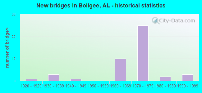
- New bridges - historical statistics
- 11920-1929
- 31930-1939
- 11940-1949
- 101960-1969
- 251970-1979
- 21980-1989
- 31990-1999


- Bridge Condition - Deck
- 2.7%Excellent
- 8.1%Very good
- 18.9%Good
- 54.1%Satisfactory
- 16.2%Fair

- Bridge Condition - Superstructure
- 2.7%Excellent
- 8.1%Very good
- 62.2%Good
- 24.3%Satisfactory
- 2.7%Fair

- Bridge Condition - Substructure
- 8.1%Very good
- 73.0%Good
- 16.2%Satisfactory
- 2.7%Poor

- Bridge Condition - Channel
- 25.8%Very good
- 54.8%Good
- 19.4%Satisfactory

- Bridge Condition - Culverts
- 33.3%Good
- 66.7%Satisfactory
Find on map >> Show street view
Structure Number: 20111, Location: 1.0 M W OF CO 89 (Lat: 32.802600, Lng: -88.053392), Route carried "on" structure: County highway 91, Year Built: 1983, Status: Open, Structure Length: 9.33m (30.61ft), Average Daily Traffic: 10 (year 2009), Average Future Daily Traffic: 20 (year 2029), Design Load: HS 20, Features Intersected: BRUSH CREEK
Minimum Vertical Clearance: 30+ m (98+ ft), Kilometerpoint: 0.000, Lanes on structure: 2, Owner: County Highway Agency, Approaching Roadway Width: 8.5m (27.9ft), Material/Design: Concrete, Design/Construction: Channel Beam, Number Of Spans In Main Unit: 9, Length of Maximum Span: 10.4m (34.1ft), Curb-To-Curb Width: 8.5m (27.9ft), Out-to-Out Width: 8.5m (27.9ft)
Condition: Deck: Very good, Superstructure: Very good, Substructure: Good, Channel: Satisfactory, Operating Rating: 40.4 metric tons, Method Used To Determine Operating Rating: Load Factor (LF), Inventory Rating: 24.2 metric tons, Method Used To Determine Inventory Rating: Load Factor (LF), Structural Evaluation: Equal to present minimum criteria, Deck Geometry: Better than present minimum criteria, Waterway Adequacy: Equal to present minimum criteria, Approach Roadway Alignment: Equal to present minimum criteria, Length Of Structure Improvement: 10.28m (33.73ft), Designated Inspection Frequency: Every 24 months, Inspection Date: August 2021, Bridge Improvement Cost: $1,974,000, Roadway Improvement Cost: $197,000, Total Project Cost: $2,171,000 ( Estimate for 2022), Deck Structure Type: Concrete Precast Panels
Find on map >> Show street view
Structure Number: 8548, Location: I-20/59 MM 36.54 (Lat: 32.829050, Lng: -87.979633), Route carried "under" structure: Interstate 20, Year Built: 1965, Structure Length: 0. m, Average Daily Traffic: 19,460 (year 2013), Truck Traffic: 44%, Features Intersected: I-20/59, Facility Carried by Structure: CR-133
Minimum Vertical Clearance: 5.06m (16.60ft), Kilometerpoint: 58.805, Lanes on structure: 2, Lanes under structure: 4, Material/Design: Concrete continuous, Design/Construction: Tee Beam, Length of Maximum Span: 20.7m (67.9ft)
Find on map >> Show street view
Structure Number: 9513, Location: 2.0 MI W of Boligee (Lat: 32.796617, Lng: -88.032850), Route carried "under" structure: Interstate 20, Year Built: 1968, Structure Length: 0. m, Average Daily Traffic: 22,070 (year 2013), Truck Traffic: 44%, Features Intersected: I-20/59
Minimum Vertical Clearance: 5.21m (17.09ft), Kilometerpoint: 52.777, Lanes on structure: 2, Lanes under structure: 4, Material/Design: Concrete continuous, Design/Construction: Tee Beam, Length of Maximum Span: 23.8m (78.1ft)
Find on map >> Show street view
Structure Number: 10481, Location: MM 29.4 on I-20/59 (Lat: 32.760567, Lng: -88.071550), Route carried "under" structure: Interstate 20, Year Built: 1971, Structure Length: 0. m, Average Daily Traffic: 22,070 (year 2013), Truck Traffic: 44%, Features Intersected: I-20/59, Facility Carried by Structure: CR-78
Minimum Vertical Clearance: 5.24m (17.19ft), Kilometerpoint: 47.270, Lanes on structure: 2, Lanes under structure: 4, Material/Design: Concrete continuous, Design/Construction: Tee Beam, Length of Maximum Span: 32.0m (105.0ft)
Find on map >> Show street view
Structure Number: 1049, Location: 1.1 MI S of Boligee (Lat: 32.782967, Lng: -88.047683), Route carried "under" structure: Interstate 20, Year Built: 1971, Structure Length: 0. m, Average Daily Traffic: 22,070 (year 2013), Truck Traffic: 44%, Features Intersected: I-20/59, Facility Carried by Structure: CR- 80
Minimum Vertical Clearance: 5.21m (17.09ft), Kilometerpoint: 50.614, Lanes on structure: 2, Lanes under structure: 4, Material/Design: Concrete, Design/Construction: Tee Beam, Length of Maximum Span: 29.0m (95.1ft)
Find on map >> Show street view
Structure Number: 12663, Location: 0.06 MI NW US 11 S BOLIGE (Lat: 32.722400, Lng: -88.069800), Route carried "under" structure: County highway , Year Built: 1940, Structure Length: 0. m, Average Daily Traffic: 30 (year 1985), Features Intersected: AGS RAILROAD, Facility Carried by Structure: AGS RAILROAD
Minimum Vertical Clearance: 3.20m (10.50ft), Kilometerpoint: 0.010, Lanes under structure: 2, Material/Design: Wood or Timber, Design/Construction: Stringer/Multi-beam, Length of Maximum Span: 3.0m (9.8ft)