Bridge Statistics for Bloomington, Minnesota (MN)
Condition, Traffic, Stress, Structural Evaluation, Project Costs
- National Bridge Inventory (NBI) Statistics
- 204Number of bridges
- 4,793ft / 1,461mTotal length
- $9,037,995,000Total costs
- 7,666,298Total average daily traffic
- 340,957Total average daily truck traffic
- National Bridge Inventory (NBI) Registered Bridges for Bloomington
- No street view available for this location
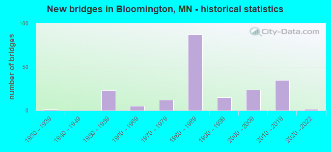
- New bridges - historical statistics
- 11930-1939
- 231950-1959
- 51960-1969
- 121970-1979
- 871980-1989
- 151990-1999
- 242000-2009
- 352010-2019
- 22020-2022

- Reconstructed bridges - Historical Statistics
- 11980-1989
- 21990-1999
- 32000-2009
- 02010-2019
- 32020-2022


- Bridge Condition - Deck
- 16.5%Very good
- 43.5%Good
- 37.6%Satisfactory
- 2.4%Fair

- Bridge Condition - Superstructure
- 17.6%Very good
- 25.9%Good
- 42.4%Satisfactory
- 14.1%Fair

- Bridge Condition - Substructure
- 5.9%Very good
- 41.2%Good
- 28.2%Satisfactory
- 24.7%Fair

- Bridge Condition - Channel
- 7.1%Excellent
- 50.0%Very good
- 14.3%Good
- 7.1%Satisfactory
- 21.4%Fair

- Bridge Condition - Culverts
- 50.0%Excellent
- 50.0%Fair
Find on map >> Show street view
Structure Number: 27V04, Location: AT THE JCT TH 169; 494 (Lat: 44.859464, Lng: -93.394372), Route carried "under" structure: Interstate 494, Year Built: 1997, Structure Length: 0. m, Average Daily Traffic: 134,000 (year 2019), Truck Traffic: 6%, Features Intersected: I 494, Facility Carried by Structure: US 169
Minimum Vertical Clearance: 4.97m (16.31ft), Kilometerpoint: 0.000, Lanes on structure: 3, Lanes under structure: 6, Material/Design: Prestressed concrete, Design/Construction: Stringer/Multi-beam, Length of Maximum Span: 36.3m (119.1ft)
Find on map >> Show street view
Structure Number: 27V33, Location: .6 MI W OF JCT TH 100 (Lat: 44.859547, Lng: -93.362189), Route carried "under" structure: Ramp Interstate 5883, Year Built: 2003, Structure Length: 0. m, Average Daily Traffic: 1,000 (year 2003), Features Intersected: I 494, Facility Carried by Structure: CSAH 28
Minimum Vertical Clearance: 4.97m (16.31ft), Kilometerpoint: 0.000, Lanes on structure: 4, Lanes under structure: 1, Material/Design: Steel continuous, Design/Construction: Stringer/Multi-beam, Length of Maximum Span: 50.7m (166.3ft)
Find on map >> Show street view
Structure Number: 27V33, Location: .6 MI W OF JCT TH 100 (Lat: 44.859547, Lng: -93.362189), Route carried "under" structure: Interstate 494, Year Built: 2003, Structure Length: 0. m, Average Daily Traffic: 145,000 (year 2019), Truck Traffic: 6%, Features Intersected: I 494, Facility Carried by Structure: CSAH 28
Minimum Vertical Clearance: 5.52m (18.11ft), Kilometerpoint: 0.000, Lanes on structure: 4, Lanes under structure: 7, Material/Design: Steel continuous, Design/Construction: Stringer/Multi-beam, Length of Maximum Span: 50.7m (166.3ft)
Find on map >> Show street view
Structure Number: 27V33, Location: .6 MI W OF JCT TH 100 (Lat: 44.859547, Lng: -93.362189), Route carried "under" structure: Ramp Interstate 5883, Year Built: 2003, Structure Length: 0. m, Average Daily Traffic: 1,000 (year 2003), Features Intersected: I 494, Facility Carried by Structure: CSAH 28
Minimum Vertical Clearance: 5.18m (16.99ft), Kilometerpoint: 0.000, Lanes under structure: 1, Material/Design: Steel continuous, Design/Construction: Stringer/Multi-beam, Length of Maximum Span: 50.7m (166.3ft)
Find on map >> Show street view
Structure Number: 27V34, Location: 0.6 MI W OF JCT TH 100 (Lat: 44.859578, Lng: -93.362686), Route carried "under" structure: Interstate 494, Year Built: 2003, Structure Length: 0. m, Average Daily Traffic: 145,000 (year 2019), Truck Traffic: 6%, Features Intersected: I 494; ON RAMP, Facility Carried by Structure: RAILROAD
Minimum Vertical Clearance: 5.49m (18.01ft), Kilometerpoint: 0.000, Lanes on structure: 7, Lanes under structure: 8, Material/Design: Steel, Design/Construction: Girder and Floorbeam System, Length of Maximum Span: 48.2m (158.1ft)
Find on map >> Show street view
Structure Number: 27V34, Location: 0.6 MI W OF JCT TH 100 (Lat: 44.859578, Lng: -93.362686), Route carried "under" structure: Ramp Interstate 5883, Year Built: 2003, Structure Length: 0. m, Average Daily Traffic: 1,000 (year 2003), Features Intersected: I 494; ON RAMP, Facility Carried by Structure: RAILROAD
Minimum Vertical Clearance: 16.67m (54.69ft), Kilometerpoint: 0.000, Lanes on structure: 1, Lanes under structure: 8, Material/Design: Steel, Design/Construction: Girder and Floorbeam System, Length of Maximum Span: 48.2m (158.1ft)
Find on map >> Show street view
Structure Number: 27V35, Location: 1.4 MI W OF JCT TH 100 (Lat: 44.860189, Lng: -93.382744), Route carried "under" structure: Interstate 494, Year Built: 2004, Structure Length: 0. m, Average Daily Traffic: 145,000 (year 2019), Truck Traffic: 6%, Features Intersected: I 494, Facility Carried by Structure: MSAS 422
Minimum Vertical Clearance: 5.06m (16.60ft), Kilometerpoint: 0.000, Lanes on structure: 4, Lanes under structure: 8, Material/Design: Prestressed concrete, Design/Construction: Stringer/Multi-beam, Length of Maximum Span: 35.9m (117.8ft)
Find on map >> Show street view
Structure Number: 27V38, Location: AT THE JCT TH 100; 494 (Lat: 44.858789, Lng: -93.350150), Route carried "under" structure: State highway 100, Year Built: 2003, Structure Length: 0. m, Average Daily Traffic: 78,000 (year 2019), Truck Traffic: 3%, Features Intersected: TH 100, Facility Carried by Structure: I 494
Minimum Vertical Clearance: 5.49m (18.01ft), Kilometerpoint: 0.000, Lanes on structure: 8, Lanes under structure: 6, Material/Design: Steel, Design/Construction: Stringer/Multi-beam, Length of Maximum Span: 61.3m (201.1ft)
Find on map >> Show street view
Structure Number: 27V45, Location: 0.5 MI W OF JCT TH 35W (Lat: 44.862011, Lng: -93.308778), Route carried "under" structure: Interstate 494, Year Built: 2001, Structure Length: 0. m, Average Daily Traffic: 157,704 (year 2019), Truck Traffic: 4%, Features Intersected: I 494, Facility Carried by Structure: CSAH 32
Minimum Vertical Clearance: 5.97m (19.59ft), Kilometerpoint: 0.000, Lanes on structure: 4, Lanes under structure: 6, Material/Design: Steel continuous, Design/Construction: Stringer/Multi-beam, Length of Maximum Span: 29.6m (97.1ft)
Find on map >> Show street view
Structure Number: 27V92, Location: 0.15 MI N OF JCT TH 494 (Lat: 44.861428, Lng: -93.394722), Route carried "under" structure: City street 176, Year Built: 2012, Structure Length: 0. m, Average Daily Traffic: 4,000 (year 2012), Features Intersected: NE LOOP 169; 78TH ST, Facility Carried by Structure: CON 17
Minimum Vertical Clearance: 8.26m (27.10ft), Kilometerpoint: 0.000, Lanes under structure: 2, Material/Design: Steel continuous, Design/Construction: Stringer/Multi-beam, Length of Maximum Span: 53.3m (174.9ft)
Find on map >> Show street view
Structure Number: 27V92, Location: 0.15 MI N OF JCT TH 494 (Lat: 44.861428, Lng: -93.394722), Route carried "under" structure: Ramp Interstate 2585, Year Built: 2012, Structure Length: 0. m, Average Daily Traffic: 37,000 (year 2012), Truck Traffic: 7%, Features Intersected: NE LOOP 169; 78TH ST, Facility Carried by Structure: CON 17
Minimum Vertical Clearance: 5.58m (18.31ft), Kilometerpoint: 0.000, Lanes under structure: 6, Material/Design: Steel continuous, Design/Construction: Stringer/Multi-beam, Length of Maximum Span: 53.3m (174.9ft)
Find on map >> Show street view
Structure Number: 27V95, Location: 0.1 MI E OF JCT TH 169 (Lat: 44.859158, Lng: -93.393897), Route carried "under" structure: Interstate 494, Year Built: 2011, Structure Length: 0. m, Average Daily Traffic: 134,000 (year 2019), Truck Traffic: 6%, Features Intersected: I 494; US 169; MARTH RD, Facility Carried by Structure: CON 18
Minimum Vertical Clearance: 9.78m (32.09ft), Kilometerpoint: 0.000, Lanes under structure: 7, Material/Design: Steel continuous, Design/Construction: Stringer/Multi-beam, Length of Maximum Span: 62.2m (204.1ft)
Find on map >> Show street view
Structure Number: 27V95, Location: 0.1 MI E OF JCT TH 169 (Lat: 44.859158, Lng: -93.393897), Route carried "under" structure: City street 1309, Year Built: 2011, Structure Length: 0. m, Average Daily Traffic: 1 (year 2011), Features Intersected: I 494; US 169; MARTH RD, Facility Carried by Structure: CON 18
Minimum Vertical Clearance: 9.39m (30.81ft), Kilometerpoint: 0.000, Lanes under structure: 3, Material/Design: Steel continuous, Design/Construction: Stringer/Multi-beam, Length of Maximum Span: 62.2m (204.1ft)
Find on map >> Show street view
Structure Number: 27V95, Location: 0.1 MI E OF JCT TH 169 (Lat: 44.859158, Lng: -93.393897), Route carried "under" structure: US 169, Year Built: 2011, Structure Length: 0. m, Average Daily Traffic: 97,000 (year 2019), Truck Traffic: 6%, Features Intersected: I 494; US 169; MARTH RD, Facility Carried by Structure: CON 18
Minimum Vertical Clearance: 5.85m (19.19ft), Kilometerpoint: 0.000, Lanes under structure: 5, Material/Design: Steel continuous, Design/Construction: Stringer/Multi-beam, Length of Maximum Span: 62.2m (204.1ft)
Find on map >> Show street view
Structure Number: 27V96, Location: 0.12 MI SE JCT 494; 169 (Lat: 44.857783, Lng: -93.395164), Route carried "under" structure: City street 1309, Year Built: 2012, Structure Length: 0. m, Average Daily Traffic: 1 (year 2012), Truck Traffic: 1%, Features Intersected: WASHINGTON AVE, Facility Carried by Structure: CON 40
Minimum Vertical Clearance: 5.33m (17.49ft), Kilometerpoint: 0.000, Lanes under structure: 3, Material/Design: Prestressed concrete, Design/Construction: Stringer/Multi-beam, Length of Maximum Span: 34.7m (113.8ft)
Find on map >> Show street view
Structure Number: 27V97, Location: 0.10 MI SE OF JCT I 494 (Lat: 44.858067, Lng: -93.393233), Route carried "under" structure: City street 1309, Year Built: 2012, Structure Length: 0. m, Average Daily Traffic: 1 (year 2012), Features Intersected: WASHINGTON AVE, Facility Carried by Structure: CON 19
Minimum Vertical Clearance: 5.43m (17.81ft), Kilometerpoint: 0.000, Lanes under structure: 2, Material/Design: Steel continuous, Design/Construction: Stringer/Multi-beam, Length of Maximum Span: 59.4m (194.9ft)
Find on map >> Show street view
Structure Number: 27V97, Location: 0.10 MI SE OF JCT I 494 (Lat: 44.858067, Lng: -93.393233), Route carried "under" structure: Ramp US 56, Year Built: 2012, Structure Length: 0. m, Average Daily Traffic: 1 (year 2021), Features Intersected: WASHINGTON AVE, Facility Carried by Structure: CON 19
Minimum Vertical Clearance: 5.18m (16.99ft), Kilometerpoint: 0.000, Lanes under structure: 2, Material/Design: Steel continuous, Design/Construction: Stringer/Multi-beam, Length of Maximum Span: 59.4m (194.9ft)
Find on map >> Show street view
Structure Number: 27W18, Location: 0.6 MI W OF JCT TH 100 (Lat: 44.859447, Lng: -93.360200), Route carried "under" structure: Interstate 494, Year Built: 2017, Structure Length: 0. m, Average Daily Traffic: 145,000 (year 2019), Truck Traffic: 6%, Features Intersected: I 494, Facility Carried by Structure: CON 28
Minimum Vertical Clearance: 5.61m (18.41ft), Kilometerpoint: 0.000, Lanes under structure: 7, Material/Design: Steel continuous, Design/Construction: Stringer/Multi-beam, Length of Maximum Span: 54.6m (179.1ft)
Find on map >> Show street view
Structure Number: 27W38, Location: 4.1 MI S OF JCT TH 494 (Lat: 44.800267, Lng: -93.289694), Route carried "under" structure: City street 1, Year Built: 2019, Structure Length: 0. m, Average Daily Traffic: 500 (year 1974), Features Intersected: BLACK DOG RD; MN RIVER, Facility Carried by Structure: I 35W
Minimum Vertical Clearance: 4.27m (14.01ft), Kilometerpoint: 0.000, Lanes under structure: 2, Material/Design: Steel continuous, Design/Construction: Stringer/Multi-beam, Length of Maximum Span: 117.3m (384.8ft)
Find on map >> Show street view
Structure Number: 27W39, Location: 4.1 MI S OF JCT TH 494 (Lat: 44.800225, Lng: -93.289900), Route carried "under" structure: City street 1, Year Built: 2020, Structure Length: 0. m, Average Daily Traffic: 500 (year 1974), Features Intersected: BLACK DOG RD; MN RIVER, Facility Carried by Structure: I 35W
Minimum Vertical Clearance: 6.49m (21.29ft), Kilometerpoint: 0.000, Lanes under structure: 2, Material/Design: Steel continuous, Design/Construction: Stringer/Multi-beam, Length of Maximum Span: 117.3m (384.8ft)
Find on map >> Show street view
Structure Number: 27W4, Location: 1.0 MI S OF JCT TH 494 (Lat: 44.847994, Lng: -93.298186), Route carried "under" structure: Interstate 35W, Year Built: 2017, Structure Length: 0. m, Average Daily Traffic: 106,000 (year 2019), Truck Traffic: 5%, Features Intersected: I 35W, Facility Carried by Structure: MSAS 129
Minimum Vertical Clearance: 5.09m (16.70ft), Kilometerpoint: 0.000, Lanes under structure: 6, Material/Design: Prestressed concrete, Design/Construction: Stringer/Multi-beam, Length of Maximum Span: 22.7m (74.5ft)
Find on map >> Show street view
Structure Number: 27W44, Location: 3.5 MI S OF JCT TH 494 (Lat: 44.811789, Lng: -93.291400), Route carried "under" structure: City street 407, Year Built: 2019, Structure Length: 0. m, Average Daily Traffic: 11,700 (year 2015), Features Intersected: 106TH ST, Facility Carried by Structure: I 35W
Minimum Vertical Clearance: 5.00m (16.40ft), Kilometerpoint: 0.000, Lanes under structure: 4, Material/Design: Prestressed concrete, Design/Construction: Stringer/Multi-beam, Length of Maximum Span: 35.8m (117.5ft)
Find on map >> Show street view
Structure Number: 6652, Location: 2.4 MI S OF JCT TH 494 (Lat: 44.829169, Lng: -93.292419), Route carried "under" structure: Interstate 35W, Year Built: 1957, Structure Length: 0. m, Average Daily Traffic: 95,000 (year 2019), Truck Traffic: 5%, Features Intersected: I 35 W, Facility Carried by Structure: RAILROAD
Minimum Vertical Clearance: 4.97m (16.31ft), Kilometerpoint: 0.000, Lanes on structure: 6, Lanes under structure: 4, Material/Design: Steel, Design/Construction: Girder and Floorbeam System, Length of Maximum Span: 19.1m (62.7ft)
Find on map >> Show street view
Structure Number: 685, Location: AT JCT TH 494; 35W (Lat: 44.861908, Lng: -93.298400), Route carried "under" structure: Interstate 35W, Year Built: 1956, Structure Length: 0. m, Average Daily Traffic: 106,000 (year 2019), Truck Traffic: 5%, Features Intersected: I 35W, Facility Carried by Structure: I 494
Minimum Vertical Clearance: 4.72m (15.49ft), Kilometerpoint: 0.000, Lanes on structure: 3, Lanes under structure: 6, Material/Design: Steel, Design/Construction: Stringer/Multi-beam, Length of Maximum Span: 17.6m (57.7ft)
Find on map >> Show street view
Structure Number: 6851, Location: AT JCT TH 494; 35W (Lat: 44.861744, Lng: -93.298417), Route carried "under" structure: Interstate 35W, Year Built: 1956, Structure Length: 0. m, Average Daily Traffic: 106,000 (year 2019), Truck Traffic: 5%, Features Intersected: I 35W, Facility Carried by Structure: I 494
Minimum Vertical Clearance: 4.76m (15.62ft), Kilometerpoint: 0.000, Lanes on structure: 3, Lanes under structure: 6, Material/Design: Steel, Design/Construction: Stringer/Multi-beam, Length of Maximum Span: 17.6m (57.7ft)
Find on map >> Show street view
Structure Number: 9041, Location: 1.5 MI S OF JCT TH 494 (Lat: 44.840778, Lng: -93.298278), Route carried "under" structure: Interstate 35W, Year Built: 1957, Structure Length: 0. m, Average Daily Traffic: 106,000 (year 2019), Truck Traffic: 5%, Features Intersected: I 35W, Facility Carried by Structure: MSAS 130
Minimum Vertical Clearance: 4.88m (16.01ft), Kilometerpoint: 0.000, Lanes on structure: 4, Lanes under structure: 6, Material/Design: Steel continuous, Design/Construction: Stringer/Multi-beam, Length of Maximum Span: 16.3m (53.5ft)
Find on map >> Show street view
Structure Number: 9053, Location: 2.0 MI S OF JCT TH 494 (Lat: 44.833550, Lng: -93.295006), Route carried "under" structure: Interstate 35W, Year Built: 1957, Structure Length: 0. m, Average Daily Traffic: 95,000 (year 2019), Truck Traffic: 5%, Features Intersected: I 35W, Facility Carried by Structure: MSAS 136
Minimum Vertical Clearance: 5.09m (16.70ft), Kilometerpoint: 0.000, Lanes on structure: 4, Lanes under structure: 6, Material/Design: Prestressed concrete, Design/Construction: Stringer/Multi-beam, Length of Maximum Span: 18.6m (61.0ft)
Find on map >> Show street view
Structure Number: 9077, Location: 1.0 MI E OF JCT TH 35W (Lat: 44.861733, Lng: -93.278297), Route carried "under" structure: Interstate 494, Year Built: 1959, Structure Length: 0. m, Average Daily Traffic: 151,000 (year 2019), Truck Traffic: 5%, Features Intersected: I 494, Facility Carried by Structure: CSAH 52
Minimum Vertical Clearance: 4.57m (14.99ft), Kilometerpoint: 0.000, Lanes on structure: 4, Lanes under structure: 6, Material/Design: Prestressed concrete, Design/Construction: Stringer/Multi-beam, Length of Maximum Span: 17.5m (57.4ft)
Find on map >> Show street view
Structure Number: 9078, Location: 1.4 MI E OF JCT TH 35W (Lat: 44.861706, Lng: -93.274392), Route carried "under" structure: Interstate 494, Year Built: 1960, Structure Length: 0. m, Average Daily Traffic: 151,000 (year 2019), Truck Traffic: 5%, Features Intersected: I 494; N; S FRONT RDS, Facility Carried by Structure: PEDESTRIAN
Minimum Vertical Clearance: 5.21m (17.09ft), Kilometerpoint: 0.000, Lanes on structure: 6, Lanes under structure: 10, Material/Design: Steel continuous, Design/Construction: Stringer/Multi-beam, Length of Maximum Span: 22.9m (75.1ft)
Find on map >> Show street view
Structure Number: 9078, Location: 1.4 MI E OF JCT TH 35W (Lat: 44.861706, Lng: -93.274392), Route carried "under" structure: City street 775, Year Built: 1960, Structure Length: 0. m, Average Daily Traffic: 800 (year 1988), Features Intersected: I 494; N; S FRONT RDS, Facility Carried by Structure: PEDESTRIAN
Minimum Vertical Clearance: 5.43m (17.81ft), Kilometerpoint: 0.000, Lanes on structure: 2, Lanes under structure: 10, Material/Design: Steel continuous, Design/Construction: Stringer/Multi-beam, Length of Maximum Span: 22.9m (75.1ft)
Find on map >> Show street view
Structure Number: 9078, Location: 1.4 MI E OF JCT TH 35W (Lat: 44.861706, Lng: -93.274392), Route carried "under" structure: City street 195, Year Built: 1960, Structure Length: 0. m, Average Daily Traffic: 800 (year 1988), Features Intersected: I 494; N; S FRONT RDS, Facility Carried by Structure: PEDESTRIAN
Minimum Vertical Clearance: 4.85m (15.91ft), Kilometerpoint: 0.000, Lanes on structure: 2, Lanes under structure: 10, Material/Design: Steel continuous, Design/Construction: Stringer/Multi-beam, Length of Maximum Span: 22.9m (75.1ft)
Find on map >> Show street view
Structure Number: 9079, Location: 1.0 MI W OF JCT TH 77 (Lat: 44.862167, Lng: -93.268158), Route carried "under" structure: Interstate 494, Year Built: 1959, Structure Length: 0. m, Average Daily Traffic: 133,000 (year 2019), Truck Traffic: 5%, Features Intersected: I 494, Facility Carried by Structure: CSAH 35
Minimum Vertical Clearance: 4.72m (15.49ft), Kilometerpoint: 0.000, Lanes on structure: 4, Lanes under structure: 6, Material/Design: Prestressed concrete, Design/Construction: Stringer/Multi-beam, Length of Maximum Span: 18.0m (59.1ft)
Find on map >> Show street view
Structure Number: 9081, Location: AT THE JCT TH 77; 494 (Lat: 44.862197, Lng: -93.247506), Route carried "under" structure: Interstate 494, Year Built: 1958, Structure Length: 0. m, Average Daily Traffic: 149,000 (year 2019), Truck Traffic: 5%, Features Intersected: I 494, Facility Carried by Structure: MN 77
Minimum Vertical Clearance: 4.66m (15.29ft), Kilometerpoint: 0.000, Lanes on structure: 2, Lanes under structure: 6, Material/Design: Prestressed concrete, Design/Construction: Stringer/Multi-beam, Length of Maximum Span: 24.7m (81.0ft)
Find on map >> Show street view
Structure Number: 9081A, Location: AT THE JCT TH 77; 494 (Lat: 44.862211, Lng: -93.247686), Route carried "under" structure: Interstate 494, Year Built: 1958, Structure Length: 0. m, Average Daily Traffic: 149,000 (year 2019), Truck Traffic: 5%, Features Intersected: I 494, Facility Carried by Structure: CON 6373
Minimum Vertical Clearance: 4.66m (15.29ft), Kilometerpoint: 0.000, Lanes on structure: 3, Lanes under structure: 6, Material/Design: Prestressed concrete, Design/Construction: Stringer/Multi-beam, Length of Maximum Span: 25.4m (83.3ft)
Find on map >> Show street view
Structure Number: 9082, Location: AT THE JCT TH 77; 494 (Lat: 44.862247, Lng: -93.247314), Route carried "under" structure: Interstate 494, Year Built: 1958, Structure Length: 0. m, Average Daily Traffic: 149,000 (year 2019), Truck Traffic: 5%, Features Intersected: I 494, Facility Carried by Structure: MN 77
Minimum Vertical Clearance: 4.69m (15.39ft), Kilometerpoint: 0.000, Lanes on structure: 3, Lanes under structure: 6, Material/Design: Prestressed concrete, Design/Construction: Stringer/Multi-beam, Length of Maximum Span: 24.7m (81.0ft)
Find on map >> Show street view
Structure Number: 9213, Location: 0.5 MI S OF JCT TH 494 (Lat: 44.855217, Lng: -93.298125), Route carried "under" structure: Interstate 35W, Year Built: 1957, Structure Length: 0. m, Average Daily Traffic: 106,000 (year 2019), Truck Traffic: 5%, Features Intersected: I 35W, Facility Carried by Structure: MSAS 354
Minimum Vertical Clearance: 4.69m (15.39ft), Kilometerpoint: 0.000, Lanes on structure: 4, Lanes under structure: 6, Material/Design: Steel continuous, Design/Construction: Stringer/Multi-beam, Length of Maximum Span: 16.3m (53.5ft)
Find on map >> Show street view
Structure Number: 9289, Location: 0.8 MI E OF JCT TH 35W (Lat: 44.861958, Lng: -93.283403), Route carried "under" structure: Interstate 494, Year Built: 1959, Structure Length: 0. m, Average Daily Traffic: 130,000 (year 2019), Truck Traffic: 5%, Features Intersected: I 494, Facility Carried by Structure: RAILROAD
Minimum Vertical Clearance: 4.66m (15.29ft), Kilometerpoint: 0.000, Lanes on structure: 8, Lanes under structure: 8, Material/Design: Steel, Design/Construction: Girder and Floorbeam System, Length of Maximum Span: 18.9m (62.0ft)
Find on map >> Show street view
Structure Number: 9600N, Location: 1.0 MI N OF JCT TH 13 (Lat: 44.827278, Lng: -93.231297), Route carried "under" structure: City street 980, Year Built: 1978, Structure Length: 0. m, Average Daily Traffic: 49 (year 1980), Features Intersected: MINNESOTA R ; BLACK DOG, Facility Carried by Structure: MN 77
Minimum Vertical Clearance: 6.61m (21.69ft), Kilometerpoint: 0.000, Lanes on structure: 3, Lanes under structure: 2, Material/Design: Steel, Design/Construction: Arch - Thru, Length of Maximum Span: 109.7m (359.9ft)
Find on map >> Show street view
Structure Number: 9600S, Location: 1.0 MI N OF JCT TH 13 (Lat: 44.827081, Lng: -93.231703), Route carried "under" structure: City street 980, Year Built: 1978, Structure Length: 0. m, Average Daily Traffic: 49 (year 1980), Features Intersected: MINNESOTA R ; BLACK DOG, Facility Carried by Structure: MN 77
Minimum Vertical Clearance: 6.68m (21.92ft), Kilometerpoint: 0.000, Lanes on structure: 3, Lanes under structure: 2, Material/Design: Steel, Design/Construction: Arch - Thru, Length of Maximum Span: 109.7m (359.9ft)