Bridge Statistics for Bloomington, Minnesota (MN)
Condition, Traffic, Stress, Structural Evaluation, Project Costs
- National Bridge Inventory (NBI) Statistics
- 204Number of bridges
- 4,793ft / 1,461mTotal length
- $9,037,995,000Total costs
- 7,666,298Total average daily traffic
- 340,957Total average daily truck traffic
- National Bridge Inventory (NBI) Registered Bridges for Bloomington
- No street view available for this location
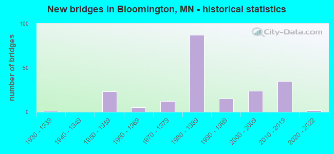
- New bridges - historical statistics
- 11930-1939
- 231950-1959
- 51960-1969
- 121970-1979
- 871980-1989
- 151990-1999
- 242000-2009
- 352010-2019
- 22020-2022

- Reconstructed bridges - Historical Statistics
- 11980-1989
- 21990-1999
- 32000-2009
- 02010-2019
- 32020-2022


- Bridge Condition - Deck
- 16.5%Very good
- 43.5%Good
- 37.6%Satisfactory
- 2.4%Fair

- Bridge Condition - Superstructure
- 17.6%Very good
- 25.9%Good
- 42.4%Satisfactory
- 14.1%Fair

- Bridge Condition - Substructure
- 5.9%Very good
- 41.2%Good
- 28.2%Satisfactory
- 24.7%Fair

- Bridge Condition - Channel
- 7.1%Excellent
- 50.0%Very good
- 14.3%Good
- 7.1%Satisfactory
- 21.4%Fair

- Bridge Condition - Culverts
- 50.0%Excellent
- 50.0%Fair
Find on map >> Show street view
Structure Number: 9081, Location: AT THE JCT TH 77; 494 (Lat: 44.862197, Lng: -93.247506), Route carried "on" structure: State highway 77, Year Built: 1958, Status: Open, Structure Length: 5.07m (16.63ft), Average Daily Traffic: 19,500 (year 2017), Truck Traffic: 3%, Average Future Daily Traffic: 19,500 (year 2039), Design Load: HS 20, Features Intersected: I 494
Minimum Vertical Clearance: 30+ m (98+ ft), Kilometerpoint: 0.000, Lanes on structure: 2, Lanes under structure: 6, Base Highway Network: Yes, Owner: State Highway Agency, Approaching Roadway Width: 12.2m (40.0ft), Material/Design: Prestressed concrete, Design/Construction: Stringer/Multi-beam, Number Of Spans In Main Unit: 2, Length of Maximum Span: 24.7m (81.0ft), Curb-To-Curb Width: 12.2m (40.0ft), Out-to-Out Width: 13.4m (44.0ft)
Condition: Deck: Satisfactory, Superstructure: Satisfactory, Substructure: Good, Operating Rating: 76.7 metric tons, Method Used To Determine Operating Rating: Load Factor (LF), Inventory Rating: 45.7 metric tons, Method Used To Determine Inventory Rating: Load Factor (LF), Structural Evaluation: Equal to present minimum criteria, Deck Geometry: Better than present minimum criteria, Underclear: Meets minimum limits, Approach Roadway Alignment: Better than present minimum criteria, Designated Inspection Frequency: Every 24 months, Inspection Date: July 2020, Deck Structure Type: Concrete Cast-file-Place, Wearing Surface/Protective System: Wearing Surface: Monolithic Concrete, Deck Protection: Epoxy Coated Reinforcing
Find on map >> Show street view
Structure Number: 9081A, Location: AT THE JCT TH 77; 494 (Lat: 44.862211, Lng: -93.247686), Route carried "on" structure: Ramp State highway 6373, Year Built: 1958, Year Reconstructed: 1987, Status: Open, Structure Length: 5.07m (16.63ft), Average Daily Traffic: 4,000 (year 1996), Average Future Daily Traffic: 4,000 (year 2029), Design Load: HS 20, Features Intersected: I 494
Minimum Vertical Clearance: 30+ m (98+ ft), Kilometerpoint: 0.000, Lanes on structure: 3, Lanes under structure: 6, Base Highway Network: Yes, Owner: State Highway Agency, Approaching Roadway Width: 14.0m (45.9ft), Material/Design: Prestressed concrete, Design/Construction: Stringer/Multi-beam, Number Of Spans In Main Unit: 2, Length of Maximum Span: 25.4m (83.3ft), Curb-To-Curb Width: 14.0m (45.9ft), Out-to-Out Width: 15.6m (51.2ft)
Condition: Deck: Satisfactory, Superstructure: Fair, Substructure: Satisfactory, Operating Rating: 76.7 metric tons, Method Used To Determine Operating Rating: Load Factor (LF), Inventory Rating: 45.7 metric tons, Method Used To Determine Inventory Rating: Load Factor (LF), Structural Evaluation: Somewhat better than minimum adequacy, Deck Geometry: Equal to present minimum criteria, Underclear: Meets minimum limits, Approach Roadway Alignment: Better than present minimum criteria, Designated Inspection Frequency: Every 24 months, Inspection Date: July 2020, Deck Structure Type: Concrete Cast-file-Place, Wearing Surface/Protective System: Wearing Surface: Monolithic Concrete, Deck Protection: Epoxy Coated Reinforcing
Find on map >> Show street view
Structure Number: 9082, Location: AT THE JCT TH 77; 494 (Lat: 44.862247, Lng: -93.247314), Route carried "on" structure: State highway 77, Year Built: 1958, Year Reconstructed: 2014, Status: Open, Structure Length: 5.00m (16.40ft), Average Daily Traffic: 22,250 (year 2019), Average Future Daily Traffic: 19,500 (year 2039), Design Load: HS 20, Features Intersected: I 494
Minimum Vertical Clearance: 30+ m (98+ ft), Kilometerpoint: 0.000, Lanes on structure: 3, Lanes under structure: 6, Base Highway Network: Yes, Owner: State Highway Agency, Approaching Roadway Width: 13.0m (42.7ft), Material/Design: Prestressed concrete, Design/Construction: Stringer/Multi-beam, Number Of Spans In Main Unit: 2, Length of Maximum Span: 24.7m (81.0ft), Curb-To-Curb Width: 13.0m (42.7ft), Out-to-Out Width: 14.0m (45.9ft)
Condition: Deck: Good, Superstructure: Satisfactory, Substructure: Satisfactory, Operating Rating: 64.0 metric tons, Method Used To Determine Operating Rating: Load Factor (LF), Inventory Rating: 44.3 metric tons, Method Used To Determine Inventory Rating: Load Factor (LF), Structural Evaluation: Equal to present minimum criteria, Deck Geometry: High priority of replacement, Underclear: Meets minimum limits, Approach Roadway Alignment: Better than present minimum criteria, Length Of Structure Improvement: 1.71m (5.61ft), Designated Inspection Frequency: Every 24 months, Inspection Date: July 2020, Bridge Improvement Cost: $999,999,000, Roadway Improvement Cost: $73,000,000, Total Project Cost: $999,999,000, Deck Structure Type: Concrete Cast-file-Place, Wearing Surface/Protective System: Wearing Surface: Epoxy Overlay, Deck Protection: Epoxy Coated Reinforcing
Find on map >> Show street view
Structure Number: 9213, Location: 0.5 MI S OF JCT TH 494 (Lat: 44.855217, Lng: -93.298125), Route carried "on" structure: City street 354, Year Built: 1957, Status: Open, Structure Length: 5.43m (17.81ft), Average Daily Traffic: 14,200 (year 2016), Average Future Daily Traffic: 14,200 (year 2039), Design Load: HS 20, Features Intersected: I 35W
Minimum Vertical Clearance: 30+ m (98+ ft), Kilometerpoint: 0.000, Lanes on structure: 4, Lanes under structure: 6, Owner: State Highway Agency, Approaching Roadway Width: 15.9m (52.2ft), Material/Design: Steel continuous, Design/Construction: Stringer/Multi-beam, Number Of Spans In Main Unit: 4, Length of Maximum Span: 16.3m (53.5ft), Curb or Sidewalk Widths: Left: 1.5m (4.9ft), Right: 1.5m (4.9ft), Curb-To-Curb Width: 15.9m (52.2ft), Out-to-Out Width: 19.6m (64.3ft)
Condition: Deck: Good, Superstructure: Good, Substructure: Satisfactory, Operating Rating: 67.6 metric tons, Method Used To Determine Operating Rating: Load Factor (LF), Inventory Rating: 40.5 metric tons, Method Used To Determine Inventory Rating: Load Factor (LF), Structural Evaluation: Equal to present minimum criteria, Deck Geometry: Meets minimum limits, Underclear: High priority of corrective action, Approach Roadway Alignment: Equal to present desirable criteria, Length Of Structure Improvement: 1.83m (6.00ft), Designated Inspection Frequency: Every 24 months, Inspection Date: August 2020, Bridge Improvement Cost: $999,999,000, Roadway Improvement Cost: $93,000,000, Total Project Cost: $999,999,000, Deck Structure Type: Concrete Cast-file-Place, Wearing Surface/Protective System: Wearing Surface: Epoxy Overlay, Deck Protection: Epoxy Coated Reinforcing
Find on map >> Show street view
Structure Number: 9289, Location: 0.8 MI E OF JCT TH 35W (Lat: 44.861958, Lng: -93.283403), Route carried "on" structure: , Year Built: 1959, Status: Open, Structure Length: 3.91m (12.83ft), Features Intersected: I 494, Facility Carried by Structure: RAILROAD
Lanes under structure: 8, Owner: Railroad, Material/Design: Steel, Design/Construction: Girder and Floorbeam System, Number Of Spans In Main Unit: 2, Length of Maximum Span: 18.9m (62.0ft), Out-to-Out Width: 11.6m (38.1ft)
Condition: Deck: Satisfactory, Superstructure: Fair, Substructure: Satisfactory, Underclear: Meets minimum limits, Bridge Posting: Required (Relationship of Operating Rating to Maximum Legal Load: > 39.9% below), Designated Inspection Frequency: Every 12 months, Inspection Date: July 2021, Deck Structure Type: Steel plate
Find on map >> Show street view
Structure Number: 9600N, Location: 1.0 MI N OF JCT TH 13 (Lat: 44.827278, Lng: -93.231297), Route carried "on" structure: State highway 77, Year Built: 1978, Status: Open, Structure Length: 157.25m (515.91ft), Average Daily Traffic: 48,000 (year 2019), Truck Traffic: 2%, Average Future Daily Traffic: 47,500 (year 2039), Design Load: HS 20+Mod, Features Intersected: MINNESOTA R ; BLACK DOG
Minimum Vertical Clearance: 6.52m (21.39ft), Kilometerpoint: 0.000, Lanes on structure: 3, Lanes under structure: 2, Base Highway Network: Yes, Owner: State Highway Agency, Approaching Roadway Width: 17.1m (56.1ft), Navigation Control: Yes ( Vertical Clearance: 16.8m (55.1ft), Horizontal Clearance: 100.9m (331.0ft)), Material/Design: Steel, Design/Construction: Arch - Thru, Number Of Spans In Main Unit: 1, Number Of Approach Spans: 42, Length of Maximum Span: 109.7m (359.9ft), Curb-To-Curb Width: 17.2m (56.4ft), Out-to-Out Width: 18.2m (59.7ft)
Condition: Deck: Satisfactory, Superstructure: Fair, Substructure: Fair, Channel: Good, Operating Rating: 58.1 metric tons, Method Used To Determine Operating Rating: Load Factor (LF), Inventory Rating: 34.9 metric tons, Method Used To Determine Inventory Rating: Load Factor (LF), Structural Evaluation: Somewhat better than minimum adequacy, Deck Geometry: Better than present minimum criteria, Underclear: Superior to present desirable criteria, Waterway Adequacy: Superior to present desirable criteria, Approach Roadway Alignment: Equal to present desirable criteria, Length Of Structure Improvement: 47.95m (157.32ft), Designated Inspection Frequency: Every 12 months, Critical Feature Inspection Frequency: Every 24 months, Underwater Inspection Frequency: Every 60 months, Inspection Date: July 2021, Critical Feature Inspection Date: July 2020, Underwater Inspection Date: November 2021, Bridge Improvement Cost: $999,999,000, Deck Structure Type: Concrete Cast-file-Place, Wearing Surface/Protective System: Wearing Surface: Low Slump Concrete, Deck Protection: Epoxy Coated Reinforcing
Find on map >> Show street view
Structure Number: 9600S, Location: 1.0 MI N OF JCT TH 13 (Lat: 44.827081, Lng: -93.231703), Route carried "on" structure: State highway 77, Year Built: 1978, Status: Open, Structure Length: 158.03m (518.47ft), Average Daily Traffic: 47,500 (year 2017), Truck Traffic: 3%, Average Future Daily Traffic: 47,500 (year 2039), Design Load: HS 20+Mod, Features Intersected: MINNESOTA R ; BLACK DOG
Minimum Vertical Clearance: 6.52m (21.39ft), Kilometerpoint: 0.000, Lanes on structure: 3, Lanes under structure: 2, Base Highway Network: Yes, Owner: State Highway Agency, Approaching Roadway Width: 17.1m (56.1ft), Navigation Control: Yes ( Vertical Clearance: 16.8m (55.1ft), Horizontal Clearance: 100.9m (331.0ft)), Material/Design: Steel, Design/Construction: Arch - Thru, Number Of Spans In Main Unit: 1, Number Of Approach Spans: 42, Length of Maximum Span: 109.7m (359.9ft), Curb-To-Curb Width: 17.2m (56.4ft), Out-to-Out Width: 18.2m (59.7ft)
Condition: Deck: Satisfactory, Superstructure: Fair, Substructure: Fair, Channel: Good, Operating Rating: 58.1 metric tons, Method Used To Determine Operating Rating: Load Factor (LF), Inventory Rating: 34.9 metric tons, Method Used To Determine Inventory Rating: Load Factor (LF), Structural Evaluation: Somewhat better than minimum adequacy, Deck Geometry: Better than present minimum criteria, Underclear: Superior to present desirable criteria, Waterway Adequacy: Superior to present desirable criteria, Approach Roadway Alignment: Equal to present desirable criteria, Length Of Structure Improvement: 48.16m (158.01ft), Designated Inspection Frequency: Every 12 months, Critical Feature Inspection Frequency: Every 24 months, Underwater Inspection Frequency: Every 60 months, Inspection Date: July 2021, Critical Feature Inspection Date: July 2020, Underwater Inspection Date: November 2021, Bridge Improvement Cost: $999,999,000, Deck Structure Type: Concrete Cast-file-Place, Wearing Surface/Protective System: Wearing Surface: Low Slump Concrete, Deck Protection: Epoxy Coated Reinforcing
Find on map >> Show street view
Structure Number: 27028, Location: 1.2 MI S OF JCT TH 494 (Lat: 44.844278, Lng: -93.246803), Route carried "under" structure: State highway 77, Year Built: 1978, Structure Length: 0. m, Average Daily Traffic: 91,000 (year 2019), Truck Traffic: 2%, Features Intersected: TH 77, Facility Carried by Structure: PEDESTRIAN
Minimum Vertical Clearance: 6.13m (20.11ft), Kilometerpoint: 0.000, Lanes on structure: 7, Lanes under structure: 7, Material/Design: Steel continuous, Design/Construction: Stringer/Multi-beam, Length of Maximum Span: 25.4m (83.3ft)
Find on map >> Show street view
Structure Number: 27045, Location: 0.7 MI S OF JCT TH 494 (Lat: 44.852275, Lng: -93.247436), Route carried "under" structure: Ramp State highway 4962, Year Built: 1988, Structure Length: 0. m, Average Daily Traffic: 2,000 (year 1996), Features Intersected: KILLEBREW DR, Facility Carried by Structure: CON 3998
Minimum Vertical Clearance: 5.30m (17.39ft), Kilometerpoint: 0.000, Lanes on structure: 1, Lanes under structure: 2, Material/Design: Steel continuous, Design/Construction: Stringer/Multi-beam, Length of Maximum Span: 42.7m (140.1ft)
Find on map >> Show street view
Structure Number: 27045, Location: 0.7 MI S OF JCT TH 494 (Lat: 44.852275, Lng: -93.247436), Route carried "under" structure: Ramp State highway 186, Year Built: 1988, Structure Length: 0. m, Average Daily Traffic: 2,000 (year 1996), Features Intersected: KILLEBREW DR, Facility Carried by Structure: CON 3998
Minimum Vertical Clearance: 12.16m (39.90ft), Kilometerpoint: 0.000, Lanes on structure: 1, Lanes under structure: 1, Material/Design: Steel continuous, Design/Construction: Stringer/Multi-beam, Length of Maximum Span: 42.7m (140.1ft)
Find on map >> Show street view
Structure Number: 27045, Location: 0.7 MI S OF JCT TH 494 (Lat: 44.852275, Lng: -93.247436), Route carried "under" structure: Ramp State highway 3791, Year Built: 1988, Structure Length: 0. m, Average Daily Traffic: 2,000 (year 1996), Features Intersected: KILLEBREW DR, Facility Carried by Structure: CON 3998
Minimum Vertical Clearance: 11.46m (37.60ft), Kilometerpoint: 0.000, Lanes on structure: 1, Lanes under structure: 1, Material/Design: Steel continuous, Design/Construction: Stringer/Multi-beam, Length of Maximum Span: 42.7m (140.1ft)
Find on map >> Show street view
Structure Number: 27045, Location: 0.7 MI S OF JCT TH 494 (Lat: 44.852275, Lng: -93.247436), Route carried "under" structure: State highway 77, Year Built: 1988, Structure Length: 0. m, Average Daily Traffic: 44,500 (year 2019), Features Intersected: KILLEBREW DR, Facility Carried by Structure: CON 3998
Minimum Vertical Clearance: 12.16m (39.90ft), Kilometerpoint: 0.000, Lanes on structure: 1, Lanes under structure: 6, Material/Design: Steel continuous, Design/Construction: Stringer/Multi-beam, Length of Maximum Span: 42.7m (140.1ft)
Find on map >> Show street view
Structure Number: 27046, Location: 0.7 MI S OF JCT TH 494 (Lat: 44.852681, Lng: -93.247428), Route carried "under" structure: Ramp State highway 186, Year Built: 1988, Structure Length: 0. m, Average Daily Traffic: 2,000 (year 1996), Features Intersected: TH 77; NB C/D, Facility Carried by Structure: CON 70
Minimum Vertical Clearance: 5.55m (18.21ft), Kilometerpoint: 0.000, Lanes on structure: 2, Lanes under structure: 1, Material/Design: Steel continuous, Design/Construction: Stringer/Multi-beam, Length of Maximum Span: 42.7m (140.1ft)
Find on map >> Show street view
Structure Number: 27046, Location: 0.7 MI S OF JCT TH 494 (Lat: 44.852681, Lng: -93.247428), Route carried "under" structure: State highway 77, Year Built: 1988, Structure Length: 0. m, Average Daily Traffic: 44,500 (year 2019), Features Intersected: TH 77; NB C/D, Facility Carried by Structure: CON 70
Minimum Vertical Clearance: 5.40m (17.72ft), Kilometerpoint: 0.000, Lanes on structure: 2, Lanes under structure: 6, Material/Design: Steel continuous, Design/Construction: Stringer/Multi-beam, Length of Maximum Span: 42.7m (140.1ft)
Find on map >> Show street view
Structure Number: 27047, Location: 0.4 MI S OF JCT TH 494 (Lat: 44.856789, Lng: -93.247253), Route carried "under" structure: Ramp State highway 1652, Year Built: 1988, Structure Length: 0. m, Average Daily Traffic: 4,000 (year 1996), Features Intersected: 81 ST, Facility Carried by Structure: CON 4962
Minimum Vertical Clearance: 12.16m (39.90ft), Kilometerpoint: 0.000, Lanes on structure: 1, Lanes under structure: 2, Material/Design: Steel continuous, Design/Construction: Stringer/Multi-beam, Length of Maximum Span: 45.7m (149.9ft)
Find on map >> Show street view
Structure Number: 27047, Location: 0.4 MI S OF JCT TH 494 (Lat: 44.856789, Lng: -93.247253), Route carried "under" structure: Ramp State highway 6355, Year Built: 1988, Structure Length: 0. m, Average Daily Traffic: 4,000 (year 1996), Features Intersected: 81 ST, Facility Carried by Structure: CON 4962
Minimum Vertical Clearance: 8.29m (27.20ft), Kilometerpoint: 0.000, Lanes on structure: 1, Lanes under structure: 2, Material/Design: Steel continuous, Design/Construction: Stringer/Multi-beam, Length of Maximum Span: 45.7m (149.9ft)
Find on map >> Show street view
Structure Number: 27047, Location: 0.4 MI S OF JCT TH 494 (Lat: 44.856789, Lng: -93.247253), Route carried "under" structure: Ramp State highway 4962, Year Built: 1988, Structure Length: 0. m, Average Daily Traffic: 4,000 (year 1996), Features Intersected: 81 ST
Minimum Vertical Clearance: 12.16m (39.90ft), Kilometerpoint: 0.000, Lanes on structure: 1, Lanes under structure: 2, Material/Design: Steel continuous, Design/Construction: Stringer/Multi-beam, Length of Maximum Span: 45.7m (149.9ft)
Find on map >> Show street view
Structure Number: 27047, Location: 0.4 MI S OF JCT TH 494 (Lat: 44.856789, Lng: -93.247253), Route carried "under" structure: Ramp State highway 6371, Year Built: 1988, Structure Length: 0. m, Average Daily Traffic: 4,000 (year 1994), Features Intersected: 81 ST, Facility Carried by Structure: CON 4962
Minimum Vertical Clearance: 12.16m (39.90ft), Kilometerpoint: 0.000, Lanes on structure: 1, Lanes under structure: 1, Material/Design: Steel continuous, Design/Construction: Stringer/Multi-beam, Length of Maximum Span: 45.7m (149.9ft)
Find on map >> Show street view
Structure Number: 27047, Location: 0.4 MI S OF JCT TH 494 (Lat: 44.856789, Lng: -93.247253), Route carried "under" structure: State highway 77, Year Built: 1988, Structure Length: 0. m, Average Daily Traffic: 44,500 (year 2019), Features Intersected: 81 ST, Facility Carried by Structure: CON 4962
Minimum Vertical Clearance: 12.16m (39.90ft), Kilometerpoint: 0.000, Lanes on structure: 1, Lanes under structure: 4, Material/Design: Steel continuous, Design/Construction: Stringer/Multi-beam, Length of Maximum Span: 45.7m (149.9ft)
Find on map >> Show street view
Structure Number: 27048, Location: 0.4 MI S OF JCT TH 494 (Lat: 44.857061, Lng: -93.247286), Route carried "under" structure: Ramp State highway 6371, Year Built: 1988, Structure Length: 0. m, Average Daily Traffic: 4,000 (year 1996), Features Intersected: TH 77; RAMPS, Facility Carried by Structure: CON 1945
Minimum Vertical Clearance: 5.40m (17.72ft), Kilometerpoint: 0.000, Lanes on structure: 2, Lanes under structure: 1, Material/Design: Steel continuous, Design/Construction: Stringer/Multi-beam, Length of Maximum Span: 49.4m (162.1ft)
Find on map >> Show street view
Structure Number: 27048, Location: 0.4 MI S OF JCT TH 494 (Lat: 44.857061, Lng: -93.247286), Route carried "under" structure: Ramp State highway 1652, Year Built: 1988, Structure Length: 0. m, Average Daily Traffic: 4,000 (year 1996), Features Intersected: TH 77; RAMPS, Facility Carried by Structure: CON 1945
Minimum Vertical Clearance: 5.43m (17.81ft), Kilometerpoint: 0.000, Lanes on structure: 2, Lanes under structure: 2, Material/Design: Steel continuous, Design/Construction: Stringer/Multi-beam, Length of Maximum Span: 49.4m (162.1ft)
Find on map >> Show street view
Structure Number: 27048, Location: 0.4 MI S OF JCT TH 494 (Lat: 44.857061, Lng: -93.247286), Route carried "under" structure: Ramp State highway 5245, Year Built: 1988, Structure Length: 0. m, Average Daily Traffic: 4,000 (year 1996), Features Intersected: TH 77; RAMPS, Facility Carried by Structure: CON 1945
Minimum Vertical Clearance: 5.27m (17.29ft), Kilometerpoint: 0.000, Lanes on structure: 2, Lanes under structure: 2, Material/Design: Steel continuous, Design/Construction: Stringer/Multi-beam, Length of Maximum Span: 49.4m (162.1ft)
Find on map >> Show street view
Structure Number: 27048, Location: 0.4 MI S OF JCT TH 494 (Lat: 44.857061, Lng: -93.247286), Route carried "under" structure: Ramp State highway 6355, Year Built: 1988, Structure Length: 0. m, Average Daily Traffic: 4,000 (year 1996), Features Intersected: TH 77; RAMPS, Facility Carried by Structure: CON 1945
Minimum Vertical Clearance: 5.33m (17.49ft), Kilometerpoint: 0.000, Lanes on structure: 2, Lanes under structure: 2, Material/Design: Steel continuous, Design/Construction: Stringer/Multi-beam, Length of Maximum Span: 49.4m (162.1ft)
Find on map >> Show street view
Structure Number: 27048, Location: 0.4 MI S OF JCT TH 494 (Lat: 44.857061, Lng: -93.247286), Route carried "under" structure: State highway 77, Year Built: 1988, Structure Length: 0. m, Average Daily Traffic: 44,500 (year 2019), Features Intersected: TH 77; RAMPS, Facility Carried by Structure: CON 1945
Minimum Vertical Clearance: 5.21m (17.09ft), Kilometerpoint: 0.000, Lanes on structure: 2, Lanes under structure: 4, Material/Design: Steel continuous, Design/Construction: Stringer/Multi-beam, Length of Maximum Span: 49.4m (162.1ft)
Find on map >> Show street view
Structure Number: 27049, Location: 0.2 MI S OF JCT TH 494; 7 (Lat: 44.859936, Lng: -93.247994), Route carried "under" structure: City street 399, Year Built: 1989, Structure Length: 0. m, Average Daily Traffic: 10,300 (year 2005), Features Intersected: AMERICAN BLVD, Facility Carried by Structure: CON 1689
Minimum Vertical Clearance: 5.09m (16.70ft), Kilometerpoint: 0.000, Lanes on structure: 2, Lanes under structure: 4, Material/Design: Steel continuous, Design/Construction: Stringer/Multi-beam, Length of Maximum Span: 20.5m (67.3ft)
Find on map >> Show street view
Structure Number: 2705, Location: 0.4 MI S OF JCT TH 494 (Lat: 44.857611, Lng: -93.246569), Route carried "under" structure: Ramp State highway 5245, Year Built: 1988, Structure Length: 0. m, Average Daily Traffic: 4,000 (year 1996), Features Intersected: 81st Street, Facility Carried by Structure: CON 2979
Minimum Vertical Clearance: 5.88m (19.29ft), Kilometerpoint: 0.000, Lanes on structure: 2, Lanes under structure: 2, Material/Design: Steel continuous, Design/Construction: Stringer/Multi-beam, Length of Maximum Span: 42.7m (140.1ft)
Find on map >> Show street view
Structure Number: 27051, Location: 0.2 MI S OF JCT TH 494 (Lat: 44.859956, Lng: -93.247458), Route carried "under" structure: City street 399, Year Built: 1988, Structure Length: 0. m, Average Daily Traffic: 10,300 (year 2005), Features Intersected: AMERICAN BLVD, Facility Carried by Structure: MN 77
Minimum Vertical Clearance: 4.94m (16.21ft), Kilometerpoint: 0.000, Lanes on structure: 4, Lanes under structure: 4, Material/Design: Concrete, Design/Construction: Frame, Length of Maximum Span: 17.7m (58.1ft)
Find on map >> Show street view
Structure Number: 27051A, Location: 0.2 MI S OF JCT TH 494 (Lat: 44.859969, Lng: -93.247667), Route carried "under" structure: City street 399, Year Built: 1988, Structure Length: 0. m, Average Daily Traffic: 10,300 (year 2005), Features Intersected: AMERICAN BLVD, Facility Carried by Structure: CON 2758
Minimum Vertical Clearance: 4.94m (16.21ft), Kilometerpoint: 0.000, Lanes on structure: 2, Lanes under structure: 4, Material/Design: Concrete, Design/Construction: Frame, Length of Maximum Span: 17.7m (58.1ft)
Find on map >> Show street view
Structure Number: 27052A, Location: AT THE JCT TH 494; 77 (Lat: 44.861197, Lng: -93.246506), Route carried "under" structure: Ramp State highway 5654, Year Built: 1989, Structure Length: 0. m, Average Daily Traffic: 1,000 (year 1994), Features Intersected: 79TH ST; TH 77 ON RAMP, Facility Carried by Structure: CON 4313
Minimum Vertical Clearance: 9.42m (30.91ft), Kilometerpoint: 0.000, Lanes on structure: 1, Lanes under structure: 1, Material/Design: Steel continuous, Design/Construction: Stringer/Multi-beam, Length of Maximum Span: 46.6m (152.9ft)
Find on map >> Show street view
Structure Number: 27052A, Location: AT THE JCT TH 494; 77 (Lat: 44.861197, Lng: -93.246506), Route carried "under" structure: City street 399, Year Built: 1989, Structure Length: 0. m, Average Daily Traffic: 9,500 (year 2005), Features Intersected: 79TH ST; TH 77 ON RAMP, Facility Carried by Structure: CON 4313
Minimum Vertical Clearance: 11.98m (39.30ft), Kilometerpoint: 0.000, Lanes on structure: 1, Lanes under structure: 6, Material/Design: Steel continuous, Design/Construction: Stringer/Multi-beam, Length of Maximum Span: 46.6m (152.9ft)
Find on map >> Show street view
Structure Number: 27052B, Location: AT THE JCT TH 77; 494 (Lat: 44.862194, Lng: -93.245681), Route carried "under" structure: Ramp State highway 5654, Year Built: 1989, Structure Length: 0. m, Average Daily Traffic: 1,000 (year 1994), Features Intersected: I 494; TH 77 NB ON RAMP, Facility Carried by Structure: CON 5772
Minimum Vertical Clearance: 8.26m (27.10ft), Kilometerpoint: 0.000, Lanes on structure: 2, Lanes under structure: 1, Material/Design: Steel continuous, Design/Construction: Stringer/Multi-beam, Length of Maximum Span: 45.1m (148.0ft)
Find on map >> Show street view
Structure Number: 27052B, Location: AT THE JCT TH 77; 494 (Lat: 44.862194, Lng: -93.245681), Route carried "under" structure: Interstate 494, Year Built: 1989, Structure Length: 0. m, Average Daily Traffic: 122,000 (year 2019), Truck Traffic: 6%, Features Intersected: I 494; TH 77 NB ON RAMP, Facility Carried by Structure: CON 5772
Minimum Vertical Clearance: 7.41m (24.31ft), Kilometerpoint: 0.000, Lanes on structure: 2, Lanes under structure: 7, Material/Design: Steel continuous, Design/Construction: Stringer/Multi-beam, Length of Maximum Span: 45.1m (148.0ft)
Find on map >> Show street view
Structure Number: 27052C, Location: AT THE JCT TH 494; 77 (Lat: 44.861061, Lng: -93.246406), Route carried "under" structure: Ramp State highway 5617, Year Built: 1989, Structure Length: 0. m, Average Daily Traffic: 6,000 (year 1994), Features Intersected: AM BLVD; 494/5 RAMPS, Facility Carried by Structure: CON 2478
Minimum Vertical Clearance: 5.33m (17.49ft), Kilometerpoint: 0.000, Lanes on structure: 2, Lanes under structure: 1, Material/Design: Steel continuous, Design/Construction: Stringer/Multi-beam, Length of Maximum Span: 62.6m (205.4ft)
Find on map >> Show street view
Structure Number: 27052C, Location: AT THE JCT TH 494; 77 (Lat: 44.861061, Lng: -93.246406), Route carried "under" structure: City street 399, Year Built: 1989, Structure Length: 0. m, Average Daily Traffic: 9,500 (year 2005), Features Intersected: AM BLVD; 494/5 RAMPS, Facility Carried by Structure: CON 2478
Minimum Vertical Clearance: 10.33m (33.89ft), Kilometerpoint: 0.000, Lanes on structure: 2, Lanes under structure: 6, Material/Design: Steel continuous, Design/Construction: Stringer/Multi-beam, Length of Maximum Span: 62.6m (205.4ft)
Find on map >> Show street view
Structure Number: 27052C, Location: AT THE JCT TH 494; 77 (Lat: 44.861061, Lng: -93.246406), Route carried "under" structure: Ramp State highway 5654, Year Built: 1989, Structure Length: 0. m, Average Daily Traffic: 1,000 (year 1994), Features Intersected: AM BLVD; 494/5 RAMPS, Facility Carried by Structure: CON 2478
Minimum Vertical Clearance: 8.69m (28.51ft), Kilometerpoint: 0.000, Lanes on structure: 2, Lanes under structure: 1, Material/Design: Steel continuous, Design/Construction: Stringer/Multi-beam, Length of Maximum Span: 62.6m (205.4ft)
Find on map >> Show street view
Structure Number: 27052D, Location: AT THE JCT TH 77; 494 (Lat: 44.862172, Lng: -93.245461), Route carried "under" structure: Interstate 494, Year Built: 1989, Structure Length: 0. m, Average Daily Traffic: 122,000 (year 2019), Truck Traffic: 6%, Features Intersected: I 494; TH 77 NB ON RAMP, Facility Carried by Structure: CON 2478
Minimum Vertical Clearance: 6.28m (20.60ft), Kilometerpoint: 0.000, Lanes on structure: 1, Lanes under structure: 7, Material/Design: Steel continuous, Design/Construction: Stringer/Multi-beam, Length of Maximum Span: 47.5m (155.8ft)
Find on map >> Show street view
Structure Number: 27052D, Location: AT THE JCT TH 77; 494 (Lat: 44.862172, Lng: -93.245461), Route carried "under" structure: Ramp State highway 5654, Year Built: 1989, Structure Length: 0. m, Average Daily Traffic: 1,000 (year 1994), Features Intersected: I 494; TH 77 NB ON RAMP, Facility Carried by Structure: CON 2478
Minimum Vertical Clearance: 10.70m (35.10ft), Kilometerpoint: 0.000, Lanes on structure: 1, Lanes under structure: 1, Material/Design: Steel continuous, Design/Construction: Stringer/Multi-beam, Length of Maximum Span: 47.5m (155.8ft)
Find on map >> Show street view
Structure Number: 27053, Location: 0.1 MI N OF JCT TH 494 (Lat: 44.863742, Lng: -93.247581), Route carried "under" structure: Ramp State highway 5772, Year Built: 1988, Structure Length: 0. m, Average Daily Traffic: 4,000 (year 1996), Features Intersected: NB off ramp to WB 494, Facility Carried by Structure: MN 77
Minimum Vertical Clearance: 5.27m (17.29ft), Kilometerpoint: 0.000, Lanes on structure: 2, Lanes under structure: 1, Material/Design: Steel continuous, Design/Construction: Stringer/Multi-beam, Length of Maximum Span: 15.2m (49.9ft)
Find on map >> Show street view
Structure Number: 27053A, Location: 0.1 MI N OF JCT TH 494 (Lat: 44.863961, Lng: -93.247742), Route carried "under" structure: Ramp State highway 5772, Year Built: 1988, Structure Length: 0. m, Average Daily Traffic: 4,000 (year 1996), Features Intersected: TH 77 NB off to I 494 WB, Facility Carried by Structure: CON 6354
Minimum Vertical Clearance: 4.91m (16.11ft), Kilometerpoint: 0.000, Lanes on structure: 2, Lanes under structure: 1, Material/Design: Steel continuous, Design/Construction: Stringer/Multi-beam, Length of Maximum Span: 15.2m (49.9ft)
Find on map >> Show street view
Structure Number: 27056, Location: 0.2 MI S OF JCT TH 494 (Lat: 44.860011, Lng: -93.246794), Route carried "under" structure: City street 399, Year Built: 1988, Structure Length: 0. m, Average Daily Traffic: 9,500 (year 2005), Features Intersected: AMERICAN BLVD, Facility Carried by Structure: CON 5617
Minimum Vertical Clearance: 5.79m (19.00ft), Kilometerpoint: 0.000, Lanes on structure: 1, Lanes under structure: 4, Material/Design: Steel continuous, Design/Construction: Stringer/Multi-beam, Length of Maximum Span: 17.8m (58.4ft)
Find on map >> Show street view
Structure Number: 27058, Location: 0.2 MI S OF JCT TH 494 (Lat: 44.859936, Lng: -93.246403), Route carried "under" structure: City street 399, Year Built: 1988, Structure Length: 0. m, Average Daily Traffic: 9,500 (year 2005), Features Intersected: AMERICAN BLVD, Facility Carried by Structure: CON 398
Minimum Vertical Clearance: 5.40m (17.72ft), Kilometerpoint: 0.000, Lanes on structure: 1, Lanes under structure: 4, Material/Design: Steel continuous, Design/Construction: Stringer/Multi-beam, Length of Maximum Span: 17.8m (58.4ft)
Find on map >> Show street view
Structure Number: 2706, Location: 1.0 MI S OF JCT TH 494 (Lat: 44.847992, Lng: -93.247428), Route carried "under" structure: State highway 77, Year Built: 1978, Structure Length: 0. m, Average Daily Traffic: 91,000 (year 2019), Truck Traffic: 2%, Features Intersected: TH 77, Facility Carried by Structure: MSAS 129
Minimum Vertical Clearance: 5.30m (17.39ft), Kilometerpoint: 0.000, Lanes on structure: 4, Lanes under structure: 6, Material/Design: Steel continuous, Design/Construction: Stringer/Multi-beam, Length of Maximum Span: 27.2m (89.2ft)
Find on map >> Show street view
Structure Number: 27062, Location: 1.7 MI S OF JCT TH 494 (Lat: 44.840844, Lng: -93.244331), Route carried "under" structure: State highway 77, Year Built: 1978, Structure Length: 0. m, Average Daily Traffic: 96,000 (year 2019), Truck Traffic: 2%, Features Intersected: TH 77, Facility Carried by Structure: CSAH 1
Minimum Vertical Clearance: 5.15m (16.90ft), Kilometerpoint: 0.000, Lanes on structure: 6, Lanes under structure: 8, Material/Design: Steel continuous, Design/Construction: Stringer/Multi-beam, Length of Maximum Span: 37.2m (122.0ft)
Find on map >> Show street view
Structure Number: 2707, Location: 0.2 MI N OF JCT TH 494 (Lat: 44.863714, Lng: -93.247331), Route carried "under" structure: Ramp State highway 5772, Year Built: 1988, Structure Length: 0. m, Average Daily Traffic: 4,000 (year 1996), Features Intersected: 77 NB off ramp to WB 494, Facility Carried by Structure: MN 77
Minimum Vertical Clearance: 5.12m (16.80ft), Kilometerpoint: 0.000, Lanes on structure: 2, Lanes under structure: 1, Material/Design: Steel continuous, Design/Construction: Stringer/Multi-beam, Length of Maximum Span: 15.2m (49.9ft)
Find on map >> Show street view
Structure Number: 27408, Location: 1.0 MI W OF JCT TH 35W (Lat: 44.861253, Lng: -93.318839), Route carried "under" structure: Interstate 494, Year Built: 2013, Structure Length: 0. m, Average Daily Traffic: 155,000 (year 2019), Truck Traffic: 4%, Features Intersected: I 494, Facility Carried by Structure: CSAH 31
Minimum Vertical Clearance: 5.40m (17.72ft), Kilometerpoint: 0.000, Lanes under structure: 7, Material/Design: Prestressed concrete, Design/Construction: Stringer/Multi-beam, Length of Maximum Span: 37.9m (124.3ft)
Find on map >> Show street view
Structure Number: 27647, Location: 0.3 MI S OF JCT TH 494 (Lat: 44.854561, Lng: -93.350197), Route carried "under" structure: County highway 34, Year Built: 1986, Structure Length: 0. m, Average Daily Traffic: 30,700 (year 2005), Features Intersected: CSAH 34; CITY STREET, Facility Carried by Structure: MSAS 433
Minimum Vertical Clearance: 5.61m (18.41ft), Kilometerpoint: 0.000, Lanes on structure: 2, Lanes under structure: 4, Material/Design: Steel continuous, Design/Construction: Stringer/Multi-beam, Length of Maximum Span: 40.3m (132.2ft)
Find on map >> Show street view
Structure Number: 27647, Location: 0.3 MI S OF JCT TH 494 (Lat: 44.854561, Lng: -93.350197), Route carried "under" structure: City street 753, Year Built: 1986, Structure Length: 0. m, Average Daily Traffic: 4,800 (year 1997), Features Intersected: CSAH 34; CITY STREET, Facility Carried by Structure: MSAS 433
Minimum Vertical Clearance: 4.94m (16.21ft), Kilometerpoint: 0.000, Lanes on structure: 2, Lanes under structure: 2, Material/Design: Steel continuous, Design/Construction: Stringer/Multi-beam, Length of Maximum Span: 40.3m (132.2ft)
Find on map >> Show street view
Structure Number: 27693, Location: 4.4 MI S OF JCT TH 494 (Lat: 44.808133, Lng: -93.398078), Route carried "under" structure: County highway 1, Year Built: 1993, Structure Length: 0. m, Average Daily Traffic: 21,700 (year 2005), Features Intersected: West 108th Street
Minimum Vertical Clearance: 5.03m (16.50ft), Kilometerpoint: 0.000, Lanes on structure: 2, Lanes under structure: 6, Material/Design: Prestressed concrete, Design/Construction: Stringer/Multi-beam, Length of Maximum Span: 29.6m (97.1ft)
Find on map >> Show street view
Structure Number: 27694, Location: 4.4 MI S OF JCT TH 494 (Lat: 44.808108, Lng: -93.398414), Route carried "under" structure: County highway 1, Year Built: 1993, Structure Length: 0. m, Average Daily Traffic: 21,700 (year 2005), Features Intersected: West 108th Street
Minimum Vertical Clearance: 5.85m (19.19ft), Kilometerpoint: 0.000, Lanes on structure: 2, Lanes under structure: 6, Material/Design: Prestressed concrete, Design/Construction: Stringer/Multi-beam, Length of Maximum Span: 29.6m (97.1ft)
Find on map >> Show street view
Structure Number: 27709, Location: 0.4 MI E OF JCT TH 77 (Lat: 44.862619, Lng: -93.237636), Route carried "under" structure: Ramp Interstate 5531, Year Built: 1989, Structure Length: 0. m, Average Daily Traffic: 5,000 (year 1994), Features Intersected: I 494 WB OFF RAMP, Facility Carried by Structure: AR 522
Minimum Vertical Clearance: 4.97m (16.31ft), Kilometerpoint: 0.000, Lanes on structure: 5, Lanes under structure: 1, Material/Design: Steel, Design/Construction: Stringer/Multi-beam, Length of Maximum Span: 21.9m (71.9ft)
Find on map >> Show street view
Structure Number: 27712, Location: 0.4 MI E OF JCT TH 77 (Lat: 44.861811, Lng: -93.237681), Route carried "under" structure: Ramp Interstate 2378, Year Built: 1989, Structure Length: 0. m, Average Daily Traffic: 5,000 (year 1994), Features Intersected: I 494 EB ON RAMP, Facility Carried by Structure: CSAH 1
Minimum Vertical Clearance: 5.27m (17.29ft), Kilometerpoint: 0.000, Lanes on structure: 6, Lanes under structure: 1, Material/Design: Steel, Design/Construction: Stringer/Multi-beam, Length of Maximum Span: 14.6m (47.9ft)
Find on map >> Show street view
Structure Number: 27735, Location: 2.5 MI S OF JCT TH 494 (Lat: 44.826339, Lng: -93.291589), Route carried "under" structure: Interstate 35W, Year Built: 1986, Structure Length: 0. m, Average Daily Traffic: 101,000 (year 2019), Truck Traffic: 5%, Features Intersected: I 35W; SB ON RAMP, Facility Carried by Structure: CSAH 1
Minimum Vertical Clearance: 5.33m (17.49ft), Kilometerpoint: 0.000, Lanes on structure: 6, Lanes under structure: 6, Material/Design: Steel continuous, Design/Construction: Stringer/Multi-beam, Length of Maximum Span: 32.1m (105.3ft)
Find on map >> Show street view
Structure Number: 27735, Location: 2.5 MI S OF JCT TH 494 (Lat: 44.826339, Lng: -93.291589), Route carried "under" structure: Ramp Interstate 126, Year Built: 1986, Structure Length: 0. m, Average Daily Traffic: 5,800 (year 1994), Features Intersected: I 35W; SB ON RAMP, Facility Carried by Structure: CSAH 1
Minimum Vertical Clearance: 5.00m (16.40ft), Kilometerpoint: 0.000, Lanes on structure: 6, Lanes under structure: 1, Material/Design: Steel continuous, Design/Construction: Stringer/Multi-beam, Length of Maximum Span: 32.1m (105.3ft)
Find on map >> Show street view
Structure Number: 27763, Location: 1.9 Mi EAST OF JCT TH 77 (Lat: 44.862831, Lng: -93.208686), Route carried "under" structure: Interstate 494, Year Built: 1982, Structure Length: 0. m, Average Daily Traffic: 127,000 (year 2019), Truck Traffic: 5%, Features Intersected: I 494; WB OFF RAMP, Facility Carried by Structure: CON 501
Minimum Vertical Clearance: 5.64m (18.50ft), Kilometerpoint: 0.000, Lanes on structure: 3, Lanes under structure: 6, Material/Design: Steel continuous, Design/Construction: Stringer/Multi-beam, Length of Maximum Span: 47.5m (155.8ft)
Find on map >> Show street view
Structure Number: 27763, Location: 1.9 Mi EAST OF JCT TH 77 (Lat: 44.862831, Lng: -93.208686), Route carried "under" structure: Ramp State highway 2456, Year Built: 1982, Structure Length: 0. m, Average Daily Traffic: 11,000 (year 1996), Features Intersected: I 494; WB OFF RAMP, Facility Carried by Structure: CON 501
Minimum Vertical Clearance: 7.13m (23.39ft), Kilometerpoint: 0.000, Lanes on structure: 3, Lanes under structure: 1, Material/Design: Steel continuous, Design/Construction: Stringer/Multi-beam, Length of Maximum Span: 47.5m (155.8ft)
Find on map >> Show street view
Structure Number: 27764, Location: 1.6 Mi E OF JCT TH 77 (Lat: 44.861697, Lng: -93.214378), Route carried "under" structure: Ramp State highway 4560, Year Built: 1983, Structure Length: 0. m, Average Daily Traffic: 6,000 (year 1996), Features Intersected: from 34th Avenue to, Facility Carried by Structure: CON 501
Minimum Vertical Clearance: 4.94m (16.21ft), Kilometerpoint: 0.000, Lanes on structure: 1, Lanes under structure: 2, Material/Design: Steel continuous, Design/Construction: Stringer/Multi-beam, Length of Maximum Span: 32.0m (105.0ft)
Find on map >> Show street view
Structure Number: 27764, Location: 1.6 Mi E OF JCT TH 77 (Lat: 44.861697, Lng: -93.214378), Route carried "under" structure: Ramp State highway 5367, Year Built: 1983, Structure Length: 0. m, Average Daily Traffic: 2,000 (year 1996), Features Intersected: from 34th Avenue to, Facility Carried by Structure: CON 501
Minimum Vertical Clearance: 5.12m (16.80ft), Kilometerpoint: 0.000, Lanes on structure: 1, Lanes under structure: 1, Material/Design: Steel continuous, Design/Construction: Stringer/Multi-beam, Length of Maximum Span: 32.0m (105.0ft)
Find on map >> Show street view
Structure Number: 27765, Location: 1.2 MI E OF JCT TH 77 (Lat: 44.862219, Lng: -93.223083), Route carried "under" structure: Other road 1, Year Built: 1983, Structure Length: 0. m, Average Daily Traffic: 19,600 (year 1999), Features Intersected: 34th Ave S, Facility Carried by Structure: I 494
Minimum Vertical Clearance: 4.88m (16.01ft), Kilometerpoint: 0.000, Lanes on structure: 8, Lanes under structure: 7, Material/Design: Steel continuous, Design/Construction: Stringer/Multi-beam, Length of Maximum Span: 30.5m (100.1ft)
Find on map >> Show street view
Structure Number: 27766, Location: 1.6 MI E OF JCT TH 77 (Lat: 44.862014, Lng: -93.214694), Route carried "under" structure: Ramp State highway 5367, Year Built: 1983, Structure Length: 0. m, Average Daily Traffic: 6,000 (year 1996), Features Intersected: TH 5;494 CONNECTOR RAMPS, Facility Carried by Structure: MN 5
Minimum Vertical Clearance: 5.24m (17.19ft), Kilometerpoint: 0.000, Lanes on structure: 2, Lanes under structure: 1, Material/Design: Steel continuous, Design/Construction: Stringer/Multi-beam, Length of Maximum Span: 26.2m (86.0ft)
Find on map >> Show street view
Structure Number: 27766, Location: 1.6 MI E OF JCT TH 77 (Lat: 44.862014, Lng: -93.214694), Route carried "under" structure: Ramp State highway 4560, Year Built: 1983, Structure Length: 0. m, Average Daily Traffic: 2,000 (year 1996), Features Intersected: TH 5;494 CONNECTOR RAMPS, Facility Carried by Structure: MN 5
Minimum Vertical Clearance: 5.15m (16.90ft), Kilometerpoint: 0.000, Lanes on structure: 2, Lanes under structure: 1, Material/Design: Steel continuous, Design/Construction: Stringer/Multi-beam, Length of Maximum Span: 26.2m (86.0ft)
Find on map >> Show street view
Structure Number: 27767, Location: 1.6 MI E OF JCT TH 77 (Lat: 44.862406, Lng: -93.214789), Route carried "under" structure: Ramp Interstate 4560, Year Built: 1982, Structure Length: 0. m, Average Daily Traffic: 6,000 (year 1996), Features Intersected: WB 494; 5 TO EB 494; 5, Facility Carried by Structure: I 494
Minimum Vertical Clearance: 5.30m (17.39ft), Kilometerpoint: 0.000, Lanes on structure: 8, Lanes under structure: 1, Material/Design: Steel continuous, Design/Construction: Stringer/Multi-beam, Length of Maximum Span: 24.0m (78.7ft)
Find on map >> Show street view
Structure Number: 27767, Location: 1.6 MI E OF JCT TH 77 (Lat: 44.862406, Lng: -93.214789), Route carried "under" structure: Ramp Interstate 5367, Year Built: 1982, Structure Length: 0. m, Average Daily Traffic: 2,000 (year 1996), Features Intersected: WB 494; 5 TO EB 494; 5, Facility Carried by Structure: I 494
Minimum Vertical Clearance: 5.24m (17.19ft), Kilometerpoint: 0.000, Lanes on structure: 8, Lanes under structure: 1, Material/Design: Steel continuous, Design/Construction: Stringer/Multi-beam, Length of Maximum Span: 24.0m (78.7ft)
Find on map >> Show street view
Structure Number: 27769, Location: 1.6 Mi East of Jct TH 77 (Lat: 44.863106, Lng: -93.214550), Route carried "under" structure: Ramp Interstate 4560, Year Built: 1983, Structure Length: 0. m, Average Daily Traffic: 5,000 (year 1996), Features Intersected: RAMPS, Facility Carried by Structure: CON 2185
Minimum Vertical Clearance: 5.09m (16.70ft), Kilometerpoint: 0.000, Lanes on structure: 1, Lanes under structure: 1, Material/Design: Steel continuous, Design/Construction: Stringer/Multi-beam, Length of Maximum Span: 29.4m (96.5ft)
Find on map >> Show street view
Structure Number: 27769, Location: 1.6 Mi East of Jct TH 77 (Lat: 44.863106, Lng: -93.214550), Route carried "under" structure: Ramp Interstate 5367, Year Built: 1983, Structure Length: 0. m, Average Daily Traffic: 2,000 (year 1996), Features Intersected: RAMPS, Facility Carried by Structure: CON 2185
Minimum Vertical Clearance: 5.18m (16.99ft), Kilometerpoint: 0.000, Lanes on structure: 1, Lanes under structure: 1, Material/Design: Steel continuous, Design/Construction: Stringer/Multi-beam, Length of Maximum Span: 29.4m (96.5ft)
Find on map >> Show street view
Structure Number: 2782, Location: 0.4 MI E OF JCT TH 77 (Lat: 44.862197, Lng: -93.237672), Route carried "under" structure: Interstate 494, Year Built: 1989, Structure Length: 0. m, Average Daily Traffic: 114,000 (year 2019), Truck Traffic: 6%, Features Intersected: I 494, Facility Carried by Structure: AR 522
Minimum Vertical Clearance: 5.30m (17.39ft), Kilometerpoint: 0.000, Lanes on structure: 6, Lanes under structure: 7, Material/Design: Steel continuous, Design/Construction: Stringer/Multi-beam, Length of Maximum Span: 27.6m (90.6ft)
Find on map >> Show street view
Structure Number: 27892, Location: 1.5 MI W OF JCT TH 35W (Lat: 44.858925, Lng: -93.328781), Route carried "under" structure: Interstate 494, Year Built: 1985, Structure Length: 0. m, Average Daily Traffic: 155,000 (year 2019), Truck Traffic: 4%, Features Intersected: I 494, Facility Carried by Structure: CSAH 17
Minimum Vertical Clearance: 5.58m (18.31ft), Kilometerpoint: 0.000, Lanes on structure: 9, Lanes under structure: 6, Material/Design: Prestressed concrete, Design/Construction: Stringer/Multi-beam, Length of Maximum Span: 30.7m (100.7ft)
Find on map >> Show street view
Structure Number: 27983, Location: 1.8 Mi East of Jct TH 77 (Lat: 44.863225, Lng: -93.210381), Route carried "under" structure: Ramp State highway 2185, Year Built: 1982, Structure Length: 0. m, Average Daily Traffic: 6,000 (year 1996), Features Intersected: I 494 WB off ramp, Facility Carried by Structure: MN 5
Minimum Vertical Clearance: 4.88m (16.01ft), Kilometerpoint: 0.000, Lanes on structure: 2, Lanes under structure: 2, Material/Design: Steel, Design/Construction: Stringer/Multi-beam, Length of Maximum Span: 53.6m (175.9ft)
Find on map >> Show street view
Structure Number: 27984, Location: 1.9 MI EAST OF JCT TH 77 (Lat: 44.862842, Lng: -93.209503), Route carried "under" structure: Interstate 494, Year Built: 1982, Structure Length: 0. m, Average Daily Traffic: 127,000 (year 2019), Truck Traffic: 5%, Features Intersected: I 494; WB OFF RAMP, Facility Carried by Structure: MN 5
Minimum Vertical Clearance: 5.76m (18.90ft), Kilometerpoint: 0.000, Lanes on structure: 2, Lanes under structure: 6, Material/Design: Steel continuous, Design/Construction: Stringer/Multi-beam, Length of Maximum Span: 60.0m (196.9ft)
Find on map >> Show street view
Structure Number: 27984, Location: 1.9 MI EAST OF JCT TH 77 (Lat: 44.862842, Lng: -93.209503), Route carried "under" structure: Ramp State highway 2456, Year Built: 1982, Structure Length: 0. m, Average Daily Traffic: 11,000 (year 1996), Features Intersected: I 494; WB OFF RAMP, Facility Carried by Structure: MN 5
Minimum Vertical Clearance: 8.05m (26.41ft), Kilometerpoint: 0.000, Lanes on structure: 2, Lanes under structure: 1, Material/Design: Steel continuous, Design/Construction: Stringer/Multi-beam, Length of Maximum Span: 60.0m (196.9ft)
Find on map >> Show street view
Structure Number: 27A36, Location: 0.4 MI E JCT TH 77; 494 (Lat: 44.863006, Lng: -93.237664), Route carried "under" structure: Other road 6, Year Built: 2002, Structure Length: 0. m, Average Daily Traffic: 50 (year 2005), Features Intersected: AIRPORT LANE, Facility Carried by Structure: AR 522
Minimum Vertical Clearance: 4.66m (15.29ft), Kilometerpoint: 0.000, Lanes on structure: 6, Lanes under structure: 2, Material/Design: Prestressed concrete, Design/Construction: Stringer/Multi-beam, Length of Maximum Span: 19.0m (62.3ft)
Find on map >> Show street view
Structure Number: 27A78, Location: 0.4 MI E JCT TH 77; 494 (Lat: 44.862217, Lng: -93.235611), Route carried "under" structure: Interstate 494, Year Built: 2002, Structure Length: 0. m, Average Daily Traffic: 114,000 (year 2019), Truck Traffic: 6%, Features Intersected: I 494; RAMPS, Facility Carried by Structure: UTILITIES
Minimum Vertical Clearance: 5.24m (17.19ft), Kilometerpoint: 0.000, Lanes on structure: 7, Lanes under structure: 11, Material/Design: Steel, Design/Construction: Stringer/Multi-beam, Length of Maximum Span: 37.1m (121.7ft)
Find on map >> Show street view
Structure Number: 27A78, Location: 0.4 MI E JCT TH 77; 494 (Lat: 44.862217, Lng: -93.235611), Route carried "under" structure: Ramp Interstate 5531, Year Built: 2002, Structure Length: 0. m, Average Daily Traffic: 5,000 (year 2002), Features Intersected: I 494; RAMPS, Facility Carried by Structure: UTILITIES
Minimum Vertical Clearance: 5.27m (17.29ft), Kilometerpoint: 0.000, Lanes on structure: 1, Lanes under structure: 11, Material/Design: Steel, Design/Construction: Stringer/Multi-beam, Length of Maximum Span: 37.1m (121.7ft)
Find on map >> Show street view
Structure Number: 27A78, Location: 0.4 MI E JCT TH 77; 494 (Lat: 44.862217, Lng: -93.235611), Route carried "under" structure: Ramp Interstate 886, Year Built: 2002, Structure Length: 0. m, Average Daily Traffic: 4,000 (year 2002), Features Intersected: I 494; RAMPS, Facility Carried by Structure: UTILITIES
Minimum Vertical Clearance: 5.24m (17.19ft), Kilometerpoint: 0.000, Lanes on structure: 2, Lanes under structure: 11, Material/Design: Steel, Design/Construction: Stringer/Multi-beam, Length of Maximum Span: 37.1m (121.7ft)
Find on map >> Show street view
Structure Number: 27R05, Location: 0.4 MI S OF JCT TH 494 (Lat: 44.858983, Lng: -93.298133), Route carried "under" structure: City street 1185, Year Built: 2004, Structure Length: 0. m, Average Daily Traffic: 500 (year 2004), Features Intersected: I 35W, HUMBOLT; BLOOM, Facility Carried by Structure: MSAS 399
Minimum Vertical Clearance: 5.12m (16.80ft), Kilometerpoint: 0.000, Lanes on structure: 4, Lanes under structure: 2, Material/Design: Prestressed concrete, Design/Construction: Stringer/Multi-beam, Length of Maximum Span: 32.1m (105.3ft)
Find on map >> Show street view
Structure Number: 27R05, Location: 0.4 MI S OF JCT TH 494 (Lat: 44.858983, Lng: -93.298133), Route carried "under" structure: City street 1371, Year Built: 2004, Structure Length: 0. m, Average Daily Traffic: 500 (year 2004), Features Intersected: I 35W, HUMBOLT; BLOOM, Facility Carried by Structure: MSAS 399
Minimum Vertical Clearance: 5.06m (16.60ft), Kilometerpoint: 0.000, Lanes on structure: 4, Lanes under structure: 2, Material/Design: Prestressed concrete, Design/Construction: Stringer/Multi-beam, Length of Maximum Span: 32.1m (105.3ft)
Find on map >> Show street view
Structure Number: 27R05, Location: 0.4 MI S OF JCT TH 494 (Lat: 44.858983, Lng: -93.298133), Route carried "under" structure: Interstate 35W, Year Built: 2004, Structure Length: 0. m, Average Daily Traffic: 106,000 (year 2019), Truck Traffic: 5%, Features Intersected: I 35W, HUMBOLT; BLOOM, Facility Carried by Structure: MSAS 399
Minimum Vertical Clearance: 5.15m (16.90ft), Kilometerpoint: 0.000, Lanes on structure: 4, Lanes under structure: 8, Material/Design: Prestressed concrete, Design/Construction: Stringer/Multi-beam, Length of Maximum Span: 32.1m (105.3ft)
Find on map >> Show street view
Structure Number: 27R25, Location: 0.09 MI S OF JCT TH494 (Lat: 44.857911, Lng: -93.394081), Route carried "under" structure: City street 1309, Year Built: 2011, Structure Length: 0. m, Average Daily Traffic: 1 (year 2011), Features Intersected: WASHINGTON AV, Facility Carried by Structure: US 169
Minimum Vertical Clearance: 5.21m (17.09ft), Kilometerpoint: 0.000, Lanes under structure: 3, Material/Design: Prestressed concrete, Design/Construction: Stringer/Multi-beam, Length of Maximum Span: 27.6m (90.6ft)
Find on map >> Show street view
Structure Number: 27R26, Location: 0.09 MI S OF JCT TH494 (Lat: 44.857964, Lng: -93.393792), Route carried "under" structure: City street 1309, Year Built: 2011, Structure Length: 0. m, Average Daily Traffic: 1 (year 2011), Features Intersected: WASHINGTON AVE, Facility Carried by Structure: US 169
Minimum Vertical Clearance: 5.30m (17.39ft), Kilometerpoint: 0.000, Lanes under structure: 3, Material/Design: Prestressed concrete, Design/Construction: Stringer/Multi-beam, Length of Maximum Span: 27.6m (90.6ft)
Find on map >> Show street view
Structure Number: 27R27, Location: 0.15 MI N OF JCT I 494 (Lat: 44.861242, Lng: -93.395408), Route carried "under" structure: City street 1355, Year Built: 2011, Structure Length: 0. m, Average Daily Traffic: 1 (year 2011), Features Intersected: W 78TH ST, Facility Carried by Structure: US 169
Minimum Vertical Clearance: 5.27m (17.29ft), Kilometerpoint: 0.000, Lanes under structure: 2, Material/Design: Prestressed concrete, Design/Construction: Stringer/Multi-beam, Length of Maximum Span: 26.8m (87.9ft)
Find on map >> Show street view
Structure Number: 27R28, Location: 0.15 M N OF JCT TH 494 (Lat: 44.861392, Lng: -93.395103), Route carried "under" structure: City street 1355, Year Built: 2011, Structure Length: 0. m, Average Daily Traffic: 1 (year 2011), Features Intersected: W 78TH ST, Facility Carried by Structure: US 169
Minimum Vertical Clearance: 5.36m (17.59ft), Kilometerpoint: 0.000, Lanes under structure: 2, Material/Design: Prestressed concrete, Design/Construction: Stringer/Multi-beam, Length of Maximum Span: 26.8m (87.9ft)
Find on map >> Show street view
Structure Number: 27R29, Location: 0.22 MI W OF JCT TH 169 (Lat: 44.859300, Lng: -93.398644), Route carried "under" structure: Ramp Interstate 40, Year Built: 2011, Structure Length: 0. m, Average Daily Traffic: 1 (year 2011), Truck Traffic: 6%, Features Intersected: I 494; RAMPS, Facility Carried by Structure: MSAS 454
Minimum Vertical Clearance: 5.67m (18.60ft), Kilometerpoint: 0.000, Lanes under structure: 1, Material/Design: Prestressed concrete, Design/Construction: Stringer/Multi-beam, Length of Maximum Span: 30.8m (101.0ft)
Find on map >> Show street view
Structure Number: 27R29, Location: 0.22 MI W OF JCT TH 169 (Lat: 44.859300, Lng: -93.398644), Route carried "under" structure: Interstate 494, Year Built: 2011, Structure Length: 0. m, Average Daily Traffic: 134,000 (year 2019), Truck Traffic: 6%, Features Intersected: I 494; RAMPS, Facility Carried by Structure: MSAS 454
Minimum Vertical Clearance: 5.27m (17.29ft), Kilometerpoint: 0.000, Lanes under structure: 7, Material/Design: Prestressed concrete, Design/Construction: Stringer/Multi-beam, Length of Maximum Span: 30.8m (101.0ft)
Find on map >> Show street view
Structure Number: 27R29, Location: 0.22 MI W OF JCT TH 169 (Lat: 44.859300, Lng: -93.398644), Route carried "under" structure: Ramp Interstate 33, Year Built: 2011, Structure Length: 0. m, Average Daily Traffic: 1 (year 2011), Truck Traffic: 6%, Features Intersected: I 494; RAMPS, Facility Carried by Structure: MSAS 454
Minimum Vertical Clearance: 5.40m (17.72ft), Kilometerpoint: 0.000, Lanes under structure: 1, Material/Design: Prestressed concrete, Design/Construction: Stringer/Multi-beam, Length of Maximum Span: 30.8m (101.0ft)
Find on map >> Show street view
Structure Number: 27R29, Location: 0.22 MI W OF JCT TH 169 (Lat: 44.859300, Lng: -93.398644), Route carried "under" structure: Ramp Interstate 40, Year Built: 2011, Structure Length: 0. m, Average Daily Traffic: 1 (year 2011), Truck Traffic: 6%, Features Intersected: I 494; RAMPS, Facility Carried by Structure: MSAS 454
Minimum Vertical Clearance: 5.33m (17.49ft), Kilometerpoint: 0.000, Lanes under structure: 1, Material/Design: Prestressed concrete, Design/Construction: Stringer/Multi-beam, Length of Maximum Span: 30.8m (101.0ft)
Find on map >> Show street view
Structure Number: 27V03, Location: AT THE JCT OF TH 169; 494 (Lat: 44.859547, Lng: -93.394714), Route carried "under" structure: Interstate 494, Year Built: 1997, Structure Length: 0. m, Average Daily Traffic: 134,000 (year 2019), Truck Traffic: 6%, Features Intersected: I 494, Facility Carried by Structure: US 169
Minimum Vertical Clearance: 5.03m (16.50ft), Kilometerpoint: 0.000, Lanes on structure: 4, Lanes under structure: 6, Material/Design: Prestressed concrete, Design/Construction: Stringer/Multi-beam, Length of Maximum Span: 36.3m (119.1ft)