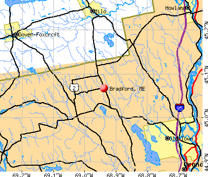
Bradford, Maine
Submit your own pictures of this town and show them to the world
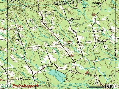
- OSM Map
- General Map
- Google Map
- MSN Map
Population change since 2000: +8.8%
 |
| Males: 664 | |
| Females: 626 |
| Median resident age: | 40.4 years |
| Maine median age: | 43.0 years |
Zip codes: 04410.
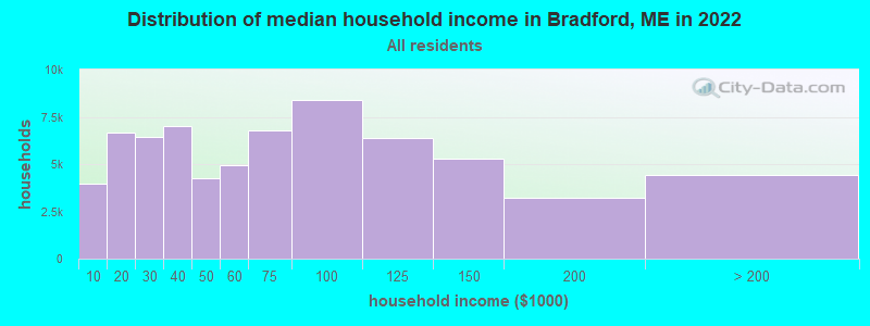
| Bradford: | $62,814 |
| ME: | $69,543 |
Estimated per capita income in 2022: $27,848 (it was $13,853 in 2000)
Bradford town income, earnings, and wages data
Estimated median house or condo value in 2022: $186,568 (it was $71,700 in 2000)
| Bradford: | $186,568 |
| ME: | $290,600 |
Mean prices in 2022: all housing units: $235,563; detached houses: $252,705; townhouses or other attached units: $267,749; in 2-unit structures: $255,332; in 3-to-4-unit structures: $815,300; in 5-or-more-unit structures: $185,873; mobile homes: $93,017; occupied boats, rvs, vans, etc.: $21,333
Detailed information about poverty and poor residents in Bradford, ME


- 1,23095.3%White alone
- 201.6%Hispanic
- 191.5%Two or more races
- 110.9%American Indian alone
- 90.7%Black alone
- 10.08%Asian alone
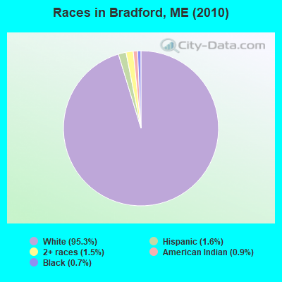
Races in Bradford detailed stats: ancestries, foreign born residents, place of birth
According to our research of Maine and other state lists, there were 5 registered sex offenders living in Bradford, Maine as of May 23, 2024.
The ratio of all residents to sex offenders in Bradford is 258 to 1.
 Recent articles from our blog. Our writers, many of them Ph.D. graduates or candidates, create easy-to-read articles on a wide variety of topics.


Latest news from Bradford, ME collected exclusively by city-data.com from local newspapers, TV, and radio stations
Ancestries: English (16.0%), French (11.6%), United States (10.1%), Irish (10.0%), Italian (5.7%), French Canadian (5.6%).
Current Local Time: EST time zone
Incorporated on 03/12/1831
Elevation: 235 feet
Land area: 41.3 square miles.
Population density: 31 people per square mile (very low).
47 residents are foreign born (1.9% North America, 1.6% Europe).
| This town: | 4.0% |
| Maine: | 2.9% |
| Bradford town: | 1.2% ($836) |
| Maine: | 1.5% ($1,417) |
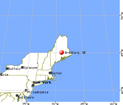
Nearest city with pop. 50,000+: Portland, ME  (119.2 miles , pop. 64,249).
Nearest city with pop. 200,000+: Boston, MA (220.2 miles , pop. 589,141).
Nearest city with pop. 1,000,000+: Bronx, NY (386.1 miles , pop. 1,332,650).
Nearest cities:
), ), ), ), ), ), Latitude: 45.09 N, Longitude: 68.91 W
Area code: 207

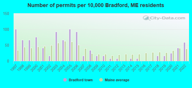
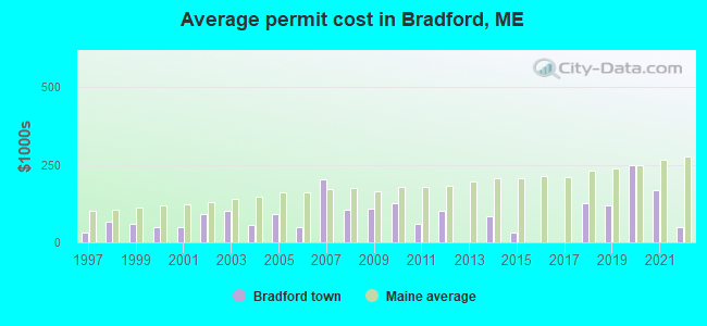
Single-family new house construction building permits:
- 2022: 7 buildings, average cost: $48,600
- 2021: 5 buildings, average cost: $170,000
- 2020: 3 buildings, average cost: $248,200
- 2019: 2 buildings, average cost: $119,000
- 2018: 2 buildings, average cost: $125,000
- 2015: 1 building, cost: $30,000
- 2014: 1 building, cost: $85,000
- 2012: 1 building, cost: $100,000
- 2011: 1 building, cost: $60,000
- 2010: 2 buildings, average cost: $125,000
- 2009: 2 buildings, average cost: $110,000
- 2008: 4 buildings, average cost: $105,500
- 2007: 2 buildings, average cost: $205,000
- 2006: 11 buildings, average cost: $49,700
- 2005: 12 buildings, average cost: $90,400
- 2004: 8 buildings, average cost: $57,300
- 2003: 11 buildings, average cost: $103,300
- 2002: 2 buildings, average cost: $90,000
- 2001: 5 buildings, average cost: $50,000
- 2000: 9 buildings, average cost: $47,900
- 1999: 8 buildings, average cost: $59,800
- 1998: 8 buildings, average cost: $66,300
- 1997: 12 buildings, average cost: $32,600
| Here: | 3.2% |
| Maine: | 3.4% |
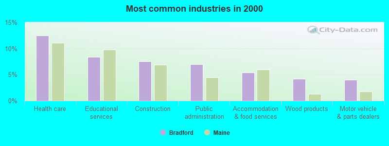
- Health care (12.5%)
- Educational services (8.3%)
- Construction (7.6%)
- Public administration (7.0%)
- Accommodation & food services (5.4%)
- Wood products (4.2%)
- Motor vehicle & parts dealers (4.0%)
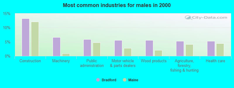
- Construction (13.3%)
- Machinery (6.6%)
- Public administration (5.9%)
- Motor vehicle & parts dealers (5.6%)
- Wood products (5.6%)
- Agriculture, forestry, fishing & hunting (5.2%)
- Health care (5.2%)
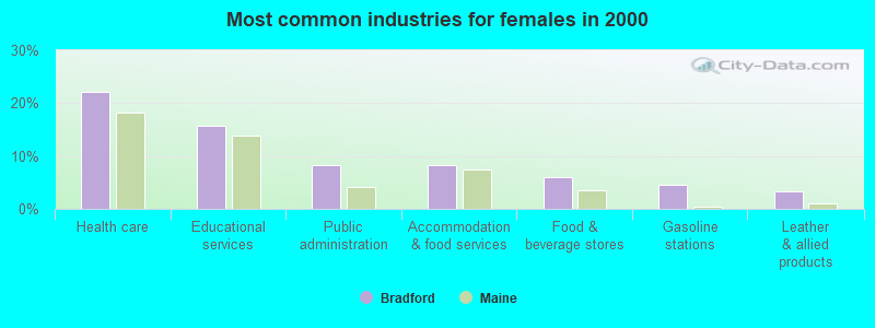
- Health care (22.1%)
- Educational services (15.7%)
- Public administration (8.3%)
- Accommodation & food services (8.3%)
- Food & beverage stores (6.0%)
- Gasoline stations (4.6%)
- Leather & allied products (3.2%)

- Metal workers and plastic workers (5.6%)
- Other office and administrative support workers, including supervisors (5.6%)
- Other production occupations, including supervisors (4.6%)
- Material recording, scheduling, dispatching, and distributing workers (4.0%)
- Driver/sales workers and truck drivers (4.0%)
- Bookkeeping, accounting, and auditing clerks (3.4%)
- Other management occupations, except farmers and farm managers (3.2%)
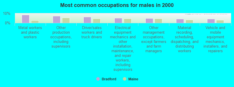
- Metal workers and plastic workers (8.4%)
- Other production occupations, including supervisors (7.3%)
- Driver/sales workers and truck drivers (6.3%)
- Electrical equipment mechanics and other installation, maintenance, and repair workers, including supervisors (5.2%)
- Other management occupations, except farmers and farm managers (4.9%)
- Material recording, scheduling, dispatching, and distributing workers (4.2%)
- Vehicle and mobile equipment mechanics, installers, and repairers (4.2%)

- Other office and administrative support workers, including supervisors (8.8%)
- Bookkeeping, accounting, and auditing clerks (7.8%)
- Preschool, kindergarten, elementary, and middle school teachers (6.0%)
- Cashiers (6.0%)
- Secretaries and administrative assistants (6.0%)
- Nursing, psychiatric, and home health aides (5.1%)
- Information and record clerks, except customer service representatives (5.1%)
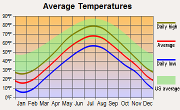
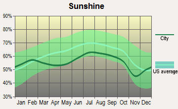
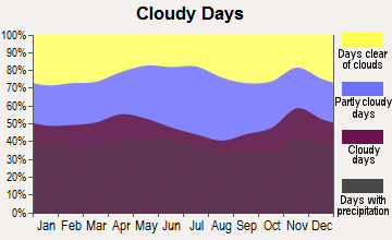
Average climate in Bradford, Maine
Based on data reported by over 4,000 weather stations
(lower is better)
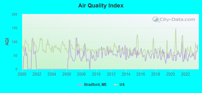
Air Quality Index (AQI) level in 2023 was 57.5. This is better than average.
| City: | 57.5 |
| U.S.: | 72.6 |
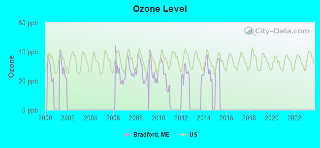
Ozone [ppb] level in 2015 was 16.3. This is significantly better than average. Closest monitor was 13.2 miles away from the city center.
| City: | 16.3 |
| U.S.: | 33.3 |
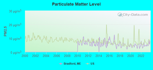
Particulate Matter (PM2.5) [µg/m3] level in 2023 was 5.62. This is significantly better than average. Closest monitor was 16.8 miles away from the city center.
| City: | 5.62 |
| U.S.: | 8.11 |
Earthquake activity:
Bradford-area historical earthquake activity is significantly above Maine state average. It is 81% smaller than the overall U.S. average.On 4/20/2002 at 10:50:47, a magnitude 5.3 (5.3 ML, Depth: 3.0 mi, Class: Moderate, Intensity: VI - VII) earthquake occurred 238.3 miles away from Bradford center
On 10/16/2012 at 23:12:25, a magnitude 4.7 (4.7 ML, Depth: 10.0 mi, Class: Light, Intensity: IV - V) earthquake occurred 134.5 miles away from Bradford center
On 4/20/2002 at 10:50:47, a magnitude 5.2 (5.2 MB, 4.2 MS, 5.2 MW, 5.0 MW) earthquake occurred 239.6 miles away from Bradford center
On 10/7/1983 at 10:18:46, a magnitude 5.3 (5.1 MB, 5.3 LG, 5.1 ML) earthquake occurred 279.1 miles away from the city center
On 1/19/1982 at 00:14:42, a magnitude 4.7 (4.5 MB, 4.7 MD, 4.5 LG) earthquake occurred 172.6 miles away from Bradford center
On 2/26/1999 at 03:38:43, a magnitude 3.8 (3.8 LG, Depth: 2.0 mi, Class: Light, Intensity: II - III) earthquake occurred 51.6 miles away from the city center
Magnitude types: regional Lg-wave magnitude (LG), body-wave magnitude (MB), duration magnitude (MD), local magnitude (ML), surface-wave magnitude (MS), moment magnitude (MW)
Natural disasters:
The number of natural disasters in Penobscot County (19) is greater than the US average (15).Major Disasters (Presidential) Declared: 11
Emergencies Declared: 7
Causes of natural disasters: Floods: 9, Storms: 8, Snows: 5, Heavy Rains: 2, Blizzard: 1, Hurricane: 1, Ice Storm: 1, Snowfall: 1, Wind: 1, Winter Storm: 1, Other: 2 (Note: some incidents may be assigned to more than one category).
Colleges/universities with over 2000 students nearest to Bradford:
- University of Maine (about 18 miles; Orono, ME; Full-time enrollment: 8,931)
- Husson University (about 19 miles; Bangor, ME; FT enrollment: 2,421)
- University of Maine at Farmington (about 68 miles; Farmington, ME; FT enrollment: 2,036)
- University of Maine at Augusta (about 68 miles; Augusta, ME; FT enrollment: 3,204)
- Saint Joseph's College of Maine (about 117 miles; Standish, ME; FT enrollment: 2,010)
- Southern Maine Community College (about 120 miles; South Portland, ME; FT enrollment: 4,666)
- University of Southern Maine (about 120 miles; Portland, ME; FT enrollment: 6,647)
Public elementary/middle school in Bradford:
- BRADFORD ELEMENTARY SCHOOL (Students: 102, Location: 641 MAIN ROAD, Grades: KG-2)
Points of interest:
Notable locations in Bradford: Bradford Station (A), Bradford Volunteer Fire Department (B), Bradford Emergency Medical Services (C). Display/hide their locations on the map
Church in Bradford: Bradford Baptist Church (A). Display/hide its location on the map
Cemeteries: Hillside Cemetery (1), Pond Cemetery (2), Williams Cemetery (3), Corner Cemetery (4), Trask Cemetery (5), Mills Cemetery (6). Display/hide their locations on the map
Streams, rivers, and creeks: West Branch Dead Stream (A), Middle Branch Dead Stream (B), Beaver Brook (C). Display/hide their locations on the map
| This town: | 2.6 people |
| Maine: | 2.3 people |
| This town: | 68.6% |
| Whole state: | 62.9% |
| This town: | 13.8% |
| Whole state: | 9.4% |
Likely homosexual households (counted as self-reported same-sex unmarried-partner households)
- Lesbian couples: 0.4% of all households
- Gay men: 0.8% of all households
| This town: | 14.6% |
| Whole state: | 10.9% |
| This town: | 4.7% |
| Whole state: | 4.1% |
For population 15 years and over in Bradford:
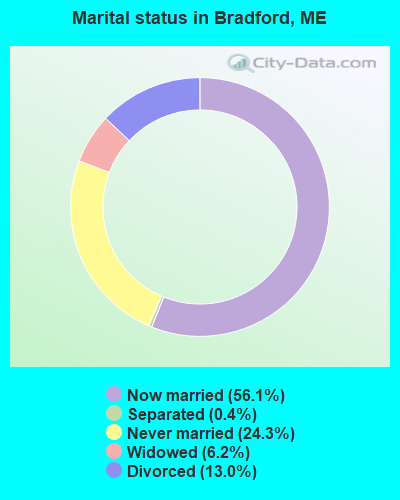
- Never married: 24.3%
- Now married: 56.1%
- Separated: 0.4%
- Widowed: 6.2%
- Divorced: 13.0%
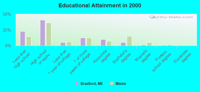
For population 25 years and over in Bradford:
- High school or higher: 77.2%
- Bachelor's degree or higher: 7.7%
- Graduate or professional degree: 2.6%
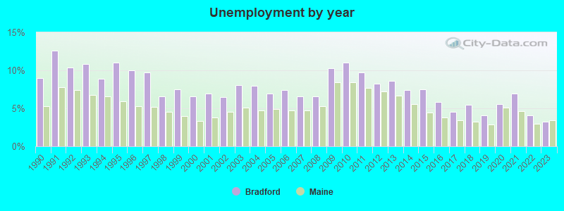
- Unemployed: 6.5%
- Mean travel time to work (commute): 40.8 minutes
| Here: | 11.4 |
| Maine average: | 11.2 |


Graphs represent county-level data. Detailed 2008 Election Results
Religion statistics for Bradford, ME (based on Penobscot County data)


| Religion | Adherents | Congregations |
|---|---|---|
| Catholic | 16,581 | 15 |
| Mainline Protestant | 9,715 | 59 |
| Evangelical Protestant | 7,523 | 80 |
| Other | 2,936 | 22 |
| Orthodox | 300 | 1 |
| None | 116,868 | - |
Food Environment Statistics:
| This county: | 2.29 / 10,000 pop. |
| State: | 2.80 / 10,000 pop. |
| Penobscot County: | 0.13 / 10,000 pop. |
| Maine: | 0.14 / 10,000 pop. |
| This county: | 2.56 / 10,000 pop. |
| State: | 2.20 / 10,000 pop. |
| Penobscot County: | 5.72 / 10,000 pop. |
| State: | 5.75 / 10,000 pop. |
| This county: | 7.41 / 10,000 pop. |
| State: | 11.02 / 10,000 pop. |
| This county: | 9.0% |
| State: | 8.2% |
| Here: | 28.0% |
| Maine: | 25.0% |
Strongest AM radio stations in Bradford:
- WZON (620 AM; 5 kW; BANGOR, ME; Owner: THE ZONE CORPORATION)
- WABI (910 AM; 5 kW; BANGOR, ME; Owner: CLEAR CHANNEL BROADCASTING LICENSES, INC.)
- WSKW (1160 AM; 10 kW; SKOWHEGAN, ME; Owner: MOUNTAIN WIRELESS, INCORPORATED)
- WNZS (1340 AM; 1 kW; VEAZIE, ME; Owner: WATERFRONT COMMUNICATIONS INC.)
- WDEA (1370 AM; 5 kW; ELLSWORTH, ME; Owner: CUMULUS LICENSING CORP.)
- WTME (780 AM; 10 kW; RUMFORD, ME; Owner: MOUNTAIN VALLEY BROADCASTING, INC.)
- WRKO (680 AM; 50 kW; BOSTON, MA; Owner: ENTERCOM BOSTON LICENSE, LLC)
- WEEI (850 AM; 50 kW; BOSTON, MA; Owner: ENTERCOM BOSTON LICENSE, LLC)
- WBZ (1030 AM; 50 kW; BOSTON, MA; Owner: INFINITY BROADCASTING OPERATIONS, INC.)
- WCRN (830 AM; 50 kW; WORCESTER, MA; Owner: CARTER BROADCASTING CORPORATION)
- WNNZ (640 AM; 50 kW; WESTFIELD, MA; Owner: CLEAR CHANNEL BROADCASTING LICENSES, INC.)
- WCHP (760 AM; 35 kW; CHAMPLAIN, NY; Owner: CHAMPLAIN RADIO, INC.)
- WKOX (1200 AM; 50 kW; FRAMINGHAM, MA; Owner: CAPSTAR TX LIMITED PARTNERSHIP)
Strongest FM radio stations in Bradford:
- WVOM (103.9 FM; HOWLAND, ME; Owner: CLEAR CHANNEL BROADCASTING LICENSES, INC.)
- WQCB (106.5 FM; BREWER, ME; Owner: CUMULUS LICENSING CORP.)
- WBZN (107.3 FM; OLD TOWN, ME; Owner: CUMULUS LICENSING CORP.)
- WHCF (88.5 FM; BANGOR, ME; Owner: BANGOR BAPTIST CHURCH)
- WWBX (97.1 FM; BANGOR, ME; Owner: CLEAR CHANNEL BROADCASTING LICENSES, INC.)
- WGUY (102.1 FM; DEXTER, ME; Owner: CONCORD MEDIA GROUP, INC.)
- WMEH (90.9 FM; BANGOR, ME; Owner: MAINE PUBLIC BROADCASTING CORPORATION)
- WKIT-FM (100.3 FM; BREWER, ME; Owner: THE ZONE CORPORATION)
- WWMJ (95.7 FM; ELLSWORTH, ME; Owner: CUMULUS LICENSING CORP.)
- WBFB (104.7 FM; BELFAST, ME; Owner: CLEAR CHANNEL BROADCASTING LICENSES, INC.)
- WEZQ (92.9 FM; BANGOR, ME; Owner: CUMULUS LICENSING CORP.)
- WTOS-FM (105.1 FM; SKOWHEGAN, ME; Owner: CAPSTAR TX LIMITED PARTNERSHIP)
- WDME-FM (103.1 FM; DOVER-FOXCROFT, ME; Owner: THE ZONE CORPORATION)
- WHMX (105.7 FM; LINCOLN, ME; Owner: BANGOR BAPTIST CHURCH)
- WMEB-FM (91.9 FM; ORONO, ME; Owner: UNIVERSITY OF MAINE SYSTEM)
TV broadcast stations around Bradford:
- WABI-TV (Channel 5; BANGOR, ME; Owner: COMMUNITY BROADCASTING SERVICE)
- WMEB-TV (Channel 12; ORONO, ME; Owner: MAINE PUBLIC BROADCASTING CORPORATION)
Bradford fatal accident list:
Dec 21, 1999 03:00 PM, Lagrange Rd, Vehicles: 2, Persons: 2, Fatalities: 1
Sep 11, 1998 04:40 PM, Sr-155, Vehicles: 1, Persons: 3, Fatalities: 1, Drunk persons involved: 1
May 16, 1988 05:15 PM, 17041705, Vehicles: 1, Persons: 1, Fatalities: 1, Drunk persons involved: 1
- National Bridge Inventory (NBI) Statistics
- 4Number of bridges
- 16ft / 4.8mTotal length
- 402,054Total average daily traffic
- 20,101Total average daily truck traffic
- 1,713Total future (year 2036) average daily traffic
FCC Registered Antenna Towers:
5- Mark L Gartley, Wilder Davis Road (Lat: 45.071028 Lon: -68.896333), Type: 78.0, Overall height: 76.2 m, Registrant: Holland & Knight LLP, Pconnolly@hklaw.Com, , Washi-ngton, Phone: (202) 862-5989
- Mark L Gartley, Wilder Davis Road (Lat: 45.071028 Lon: -68.896333), Type: 78.0, Overall height: 76.2 m, Registrant: Holland & Knight LLP, Pconnolly@hklaw.Com, , Washi-ngton, Phone: (202) 862-5989
- STEVEN T CAMPBELL, Wilder Davis Road (Lat: 45.071028 Lon: -68.896333), Type: 78.0, Structure height: 23019 m, Overall height: 76.2 m, Registrant: Holland & Knight LLP, Peter.Connolly@hklaw.Com, , Washi-ngton, Phone: (202) 862-5989
- Kristopher D Williams, Wilder Davis Road (Lat: 45.071000 Lon: -68.896333), Type: 77.7, Structure height: 23019 m, Overall height: 76.5 m, Registrant: Holland & Knight LLP, Peter.Connolly@hklaw.Com, , Washi-ngton, Phone: (202) 862-5989
- Kristopher D Williams, Wilder Davis Road (Lat: 45.071000 Lon: -68.896333), Type: 77.7, Structure height: 23019 m, Overall height: 76.5 m, Registrant: Holland & Knight LLP, Peter.Connolly@hklaw.Com, , Washi-ngton, Phone: (202) 862-5989
FCC Registered Broadcast Land Mobile Towers:
1- East Rd (Lat: 45.072833 Lon: -68.902250), Call Sign: WBA672, Licensee ID: L00046646,
Assigned Frequencies: 158.760 MHz, Grant Date: 04/22/2015, Expiration Date: 04/03/2025, Registrant: County Of Penobscot
FCC Registered Microwave Towers:
2- BRADFORD CENTER_USF, Wilder Davis Road (Lat: 45.071028 Lon: -68.896333), Type: Tower, Structure height: 76.2 m, Overall height: 78 m, Call Sign: WQOF220,
Assigned Frequencies: 6063.80 MHz, 6226.89 MHz, Grant Date: 08/03/2021, Expiration Date: 09/07/2031, Certifier: Steven T Campbell, Registrant: Wilkinson Barker Knauer, LLP, 1800 M Street Nw, Suite 800n, Washington, DC 20036, Phone: (202) 383-3420, Fax: (202) 783-5851, Email:
- Bradford, 27 Wilder Davis Road (Lat: 45.071000 Lon: -68.896278), Type: Ltower, Structure height: 76.2 m, Overall height: 76.5 m, Call Sign: WQTK335,
Assigned Frequencies: 11305.0 MHz, 11305.0 MHz, 11305.0 MHz, 11305.0 MHz, 11305.0 MHz, 11305.0 MHz, 11305.0 MHz, 11305.0 MHz, 11305.0 MHz, 11385.0 MHz... (+26 more), Grant Date: 02/21/2014, Expiration Date: 02/21/2024, Cancellation Date: 07/24/2020, Certifier: Jessica B Lyons, Registrant: At&t Mobility LLC, 208 S. Akard Street, Room 2100, Dallas, TX 75202, Phone: (855) 699-7073, Email:
FCC Registered Amateur Radio Licenses:
7- Call Sign: KB1DRU, Licensee ID: L00244849, Grant Date: 03/24/1999, Expiration Date: 02/16/2009, Cancellation Date: 02/17/2011, Certifier: Brandon Z Tarbet, Registrant: Brandon Z Tarbet, 144 Atkinson Rd, Bradford, ME 04410
- Call Sign: KD1XU, Licensee ID: L00244848, Grant Date: 09/16/2014, Expiration Date: 09/16/2024, Certifier: Don D Tarbet, Registrant: Don D Tarbet, 144 Atkinson Rd, Bradford, ME 04410
- Call Sign: KB1JXZ, Licensee ID: L00681992, Grant Date: 03/08/2013, Expiration Date: 05/08/2023, Certifier: Carol A Rickards, Registrant: Carol A Rickards, 94 Reeves Rd, Bradford, ME 04410-3422
- Call Sign: KB1NLB, Licensee ID: L01140353, Grant Date: 04/13/2006, Expiration Date: 04/13/2016, Cancellation Date: 04/14/2018, Certifier: Krisy L Tear, Registrant: Krisy L Tear, Bradford, ME 04410
- Call Sign: KB1UJS, Licensee ID: L01575068, Grant Date: 03/26/2020, Expiration Date: 06/10/2030, Certifier: Kenneth A Worster, Registrant: Kenneth A Worster, 185 Wilder Davis Rd, Bradford, ME 04410
- Call Sign: KB1VTD, Licensee ID: L01638076, Grant Date: 05/04/2021, Expiration Date: 05/13/2031, Certifier: Jenny M Worster, Registrant: Jenny M Worster, 185 Wilder Davis Rd, Bradford, ME 04410
- Call Sign: KC1HEX, Licensee ID: L02089659, Grant Date: 03/15/2017, Expiration Date: 03/15/2027, Certifier: Alexander D Malin, Registrant: Alexander D Malin, 613 Storer Rd, Bradford, ME 04410
2003 - 2018 National Fire Incident Reporting System (NFIRS) incidents
- Fire incident types reported to NFIRS in Bradford, ME
- 13367.2%Structure Fires
- 3618.2%Outside Fires
- 2211.1%Mobile Property/Vehicle Fires
- 73.5%Other
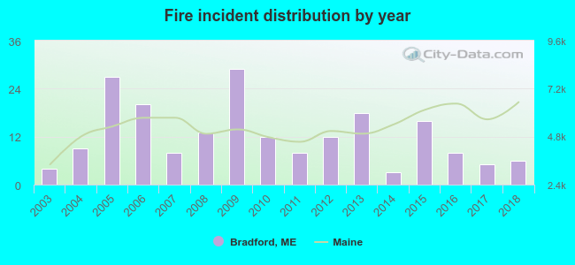 According to the data from the years 2003 - 2018 the average number of fire incidents per year is 12. The highest number of reported fires - 29 took place in 2009, and the least - 3 in 2014. The data has an increasing trend.
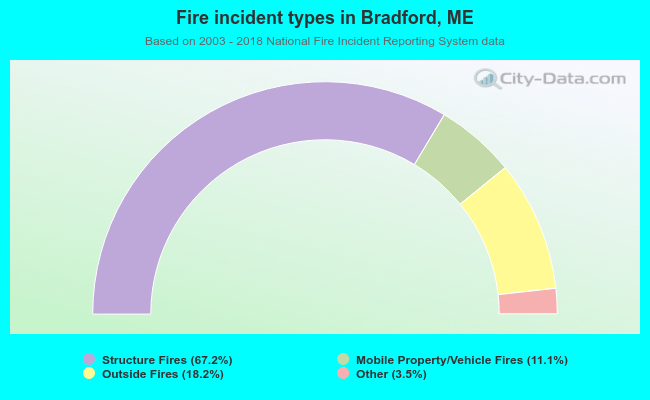 When looking into fire subcategories, the most incidents belonged to: Structure Fires (67.2%), and Outside Fires (18.2%).
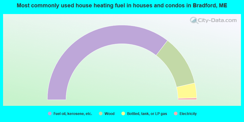
- 70.8%Fuel oil, kerosene, etc.
- 21.9%Wood
- 6.4%Bottled, tank, or LP gas
- 0.8%Electricity
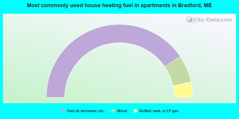
- 81.1%Fuel oil, kerosene, etc.
- 12.2%Wood
- 6.8%Bottled, tank, or LP gas
Bradford compared to Maine state average:
- Median house value below state average.
- Unemployed percentage below state average.
- Black race population percentage below state average.
- Renting percentage below state average.
- Length of stay since moving in significantly above state average.
- Number of rooms per house significantly below state average.
- House age significantly below state average.
- Percentage of population with a bachelor's degree or higher significantly below state average.
Bradford on our top lists:
- #63 on the list of "Top 101 cities with the most residents born in Other Northern America (population 500+)"
- #26 on the list of "Top 101 counties with the highest percentage of residents that smoked 100+ cigarettes in their lives"
- #27 on the list of "Top 101 counties with the highest percentage of residents that drank alcohol in the past 30 days"
- #28 on the list of "Top 101 counties with highest percentage of residents voting for 3rd party candidates in the 2012 Presidential Election (pop. 50,000+)"
- #42 on the list of "Top 101 counties with the lowest number of births per 1000 residents 2007-2013"
- #44 on the list of "Top 101 counties with the lowest percentage of residents relocating to foreign countries in 2011 (pop. 50,000+)"

|
Total of 1 patent application in 2008-2024.