Alton, Maine
Submit your own pictures of this town and show them to the world
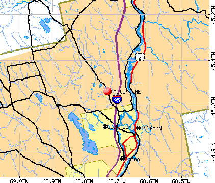
- OSM Map
- General Map
- Google Map
- MSN Map
Population change since 2000: +9.1%
 |
| Males: 439 | |
| Females: 451 |
| Median resident age: | 39.3 years |
| Maine median age: | 43.0 years |
Zip codes: 04468.
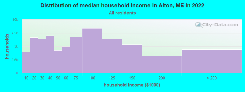
| Alton: | $62,898 |
| ME: | $69,543 |
Estimated per capita income in 2022: $28,554 (it was $14,204 in 2000)
Alton town income, earnings, and wages data
Estimated median house or condo value in 2022: $176,160 (it was $67,700 in 2000)
| Alton: | $176,160 |
| ME: | $290,600 |
Mean prices in 2022: all housing units: $235,563; detached houses: $252,705; townhouses or other attached units: $267,749; in 2-unit structures: $255,332; in 3-to-4-unit structures: $815,300; in 5-or-more-unit structures: $185,873; mobile homes: $93,017; occupied boats, rvs, vans, etc.: $21,333
Detailed information about poverty and poor residents in Alton, ME


Compare current foreclosures near Alton, ME:
| Photo | Address | Area | Beds / Baths | Price | Details |
|---|---|---|---|---|---|

|
#1
Davenport St
Milford, ME 04461
|
1,200 sq. feet
|
2 baths 3 beds |
$269,900
|
show details |

|
#2
Kenduskeag Levant Rd
Kenduskeag, ME 04450
|
- sq. feet
|
2 baths 3 beds |
show details | |

|
#3
Upper Cross Rd
Hudson, ME 04449
|
1,344 sq. feet
|
2 baths 3 beds |
show details | |

|
#4
Lincoln St
Old Town, ME 04468
|
725 sq. feet
|
1 baths 3 beds |
show details | |

|
#5
Elm St
Bangor, ME 04401
|
1,700 sq. feet
|
2 baths 4 beds |
show details | |

|
#6
Grove St
Bangor, ME 04401
|
910 sq. feet
|
1 baths 3 beds |
show details | |

|
#7
Allen St
Bangor, ME 04401
|
1,200 sq. feet
|
1 baths 3 beds |
show details | |

|
#8
Pine St # B
Bangor, ME 04401
|
- sq. feet
|
- baths - beds |
show details | |

|
#9
Stillwater Ave
Bangor, ME 04401
|
- sq. feet
|
- baths - beds |
show details | |

|
#10
Morison Ave
Corinth, ME 04427
|
- sq. feet
|
- baths - beds |
show details |
| Photo | Address | Area | Beds / Baths | Price | Details |
|---|---|---|---|---|---|

|
#11
Exeter Rd
Corinth, ME 04427
|
- sq. feet
|
- baths - beds |
show details | |

|
#12
Broadway
Kenduskeag, ME 04450
|
- sq. feet
|
- baths - beds |
show details | |

|
#13
Cedar St Apt 4
Bangor, ME 04401
|
- sq. feet
|
- baths - beds |
show details | |

|
#14
Summer St
Old Town, ME 04468
|
- sq. feet
|
- baths - beds |
show details | |

|
#15
Baker Blvd Ste 205
Brewer, ME 04412
|
- sq. feet
|
- baths - beds |
show details | |

|
#16
Call Rd # D
Milford, ME 04461
|
- sq. feet
|
- baths - beds |
show details | |

|
#17
Harris Rd Apt 31
Orono, ME 04473
|
- sq. feet
|
- baths - beds |
show details | |

|
#18
Treats Falls Dr
Brewer, ME 04412
|
- sq. feet
|
- baths - beds |
show details | |

|
#19
Cedar Breeze N
Bangor, ME 04401
|
- sq. feet
|
- baths - beds |
show details | |
|
|
#20
York Rd
Bangor, ME 04401
|
- sq. feet
|
- baths - beds |
show details |
| Photo | Address | Area | Beds / Baths | Price | Details |
|---|---|---|---|---|---|

|
#21
Kenduskeag Ave # 24
Bangor, ME 04401
|
- sq. feet
|
- baths - beds |
show details | |

|
#22
Main St
Bangor, ME 04401
|
- sq. feet
|
- baths - beds |
show details | |

|
#23
Greenfield Rd
Greenbush, ME 04418
|
- sq. feet
|
- baths - beds |
show details | |

|
#24
Aa Landing Rd
Bangor, ME 04401
|
- sq. feet
|
- baths - beds |
show details | |

|
#25
Hudson Hill Rd
Hudson, ME 04449
|
- sq. feet
|
- baths - beds |
show details | |

|
#26
Main Rd
West Enfield, ME 04493
|
- sq. feet
|
- baths - beds |
show details | |

|
Check over 1 million property listings on Foreclosure.com!
|
browse all offers | |||

- 86497.1%White alone
- 121.3%American Indian alone
- 40.4%Two or more races
- 40.4%Hispanic
- 30.3%Black alone
- 30.3%Asian alone
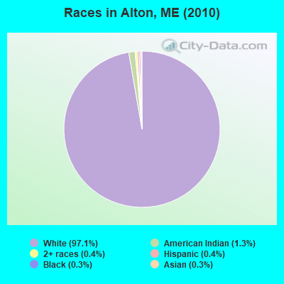
Races in Alton detailed stats: ancestries, foreign born residents, place of birth
According to our research of Maine and other state lists, there were 3 registered sex offenders living in Alton, Maine as of May 23, 2024.
The ratio of all residents to sex offenders in Alton is 297 to 1.
 Recent articles from our blog. Our writers, many of them Ph.D. graduates or candidates, create easy-to-read articles on a wide variety of topics.

 | Machiasport? (8 replies) |
| Does this area have what I'm looking for? (6 replies) |
| Afterhours Fun (12 replies) |
| Possible move to Bangor...... (56 replies) |
| Bangor area nightlife...? (56 replies) |
| Some quick and random questions about Orono and Old Town (9 replies) |
Latest news from Alton, ME collected exclusively by city-data.com from local newspapers, TV, and radio stations
Ancestries: United States (17.6%), French (14.2%), English (13.8%), Irish (13.4%), French Canadian (3.9%), German (3.4%).
Current Local Time: EST time zone
Incorporated on 03/09/1844
Elevation: 170 feet
Land area: 42.4 square miles.
Population density: 21 people per square mile (very low).
6 residents are foreign born
| This town: | 0.7% |
| Maine: | 2.9% |
| Alton town: | 1.4% ($948) |
| Maine: | 1.5% ($1,417) |
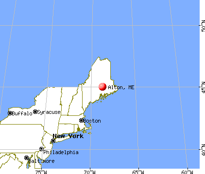
Nearest city with pop. 50,000+: Portland, ME  (120.2 miles , pop. 64,249).
Nearest city with pop. 200,000+: Boston, MA (220.4 miles , pop. 589,141).
Nearest city with pop. 1,000,000+: Bronx, NY (388.0 miles , pop. 1,332,650).
Nearest cities:
), ), ), ), Latitude: 45.03 N, Longitude: 68.76 W
Area code: 207

Single-family new house construction building permits:
- 2022: 1 building, cost: $20,000
- 2021: 1 building, cost: $20,000
- 2020: 1 building, cost: $20,000
- 2019: 1 building, cost: $20,000
- 2018: 1 building, cost: $20,000
- 2017: 1 building, cost: $20,000
- 2016: 1 building, cost: $20,000
- 2015: 1 building, cost: $20,000
- 2014: 1 building, cost: $20,000
- 2013: 1 building, cost: $20,000
- 2012: 1 building, cost: $50,000
- 2011: 1 building, cost: $94,000
- 2010: 1 building, cost: $94,000
- 2009: 3 buildings, average cost: $17,000
- 2008: 5 buildings, average cost: $40,400
- 2007: 11 buildings, average cost: $45,100
- 2006: 6 buildings, average cost: $80,000
- 2005: 5 buildings, average cost: $109,800
- 2004: 4 buildings, average cost: $100,000
- 2003: 5 buildings, average cost: $108,000
- 2002: 5 buildings, average cost: $96,000
| Here: | 4.3% |
| Maine: | 3.4% |

- Health care (12.1%)
- Educational services (8.5%)
- Construction (7.3%)
- Finance & insurance (5.4%)
- Public administration (4.5%)
- Truck transportation (3.5%)
- Accommodation & food services (3.3%)

- Construction (13.9%)
- Truck transportation (7.2%)
- Motor vehicle & parts dealers (6.2%)
- Public administration (6.2%)
- Agriculture, forestry, fishing & hunting (4.8%)
- Other transportation, support activities, couriers (3.8%)
- Health care (3.4%)

- Health care (20.5%)
- Educational services (13.5%)
- Finance & insurance (9.8%)
- Social assistance (5.6%)
- Food & beverage stores (5.1%)
- Accommodation & food services (5.1%)
- Paper (3.3%)

- Other production occupations, including supervisors (6.9%)
- Driver/sales workers and truck drivers (5.9%)
- Other sales and related occupations, including supervisors (4.5%)
- Electrical equipment mechanics and other installation, maintenance, and repair workers, including supervisors (4.5%)
- Secretaries and administrative assistants (3.8%)
- Building and grounds cleaning and maintenance occupations (3.5%)
- Retail sales workers, except cashiers (3.5%)

- Driver/sales workers and truck drivers (12.0%)
- Electrical equipment mechanics and other installation, maintenance, and repair workers, including supervisors (9.1%)
- Other production occupations, including supervisors (6.7%)
- Vehicle and mobile equipment mechanics, installers, and repairers (6.2%)
- Construction traders workers except carpenters, electricians, painters, plumbers, and construction laborers (5.8%)
- Retail sales workers, except cashiers (5.3%)
- Laborers and material movers, hand (3.8%)

- Secretaries and administrative assistants (7.4%)
- Building and grounds cleaning and maintenance occupations (7.0%)
- Other production occupations, including supervisors (7.0%)
- Other sales and related occupations, including supervisors (6.5%)
- Other office and administrative support workers, including supervisors (5.6%)
- Cashiers (5.6%)
- Registered nurses (4.7%)
Average climate in Alton, Maine
Based on data reported by over 4,000 weather stations


(lower is better)
Air Quality Index (AQI) level in 2023 was 61.1. This is about average.
| City: | 61.1 |
| U.S.: | 72.6 |
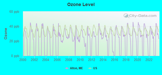
Ozone [ppb] level in 2023 was 33.6. This is about average. Closest monitor was 6.2 miles away from the city center.
| City: | 33.6 |
| U.S.: | 33.3 |
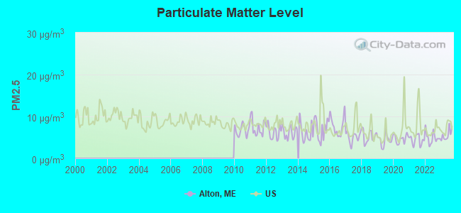
Particulate Matter (PM2.5) [µg/m3] level in 2023 was 5.62. This is significantly better than average. Closest monitor was 8.5 miles away from the city center.
| City: | 5.62 |
| U.S.: | 8.11 |
Earthquake activity:
Alton-area historical earthquake activity is significantly above Maine state average. It is 82% smaller than the overall U.S. average.On 4/20/2002 at 10:50:47, a magnitude 5.3 (5.3 ML, Depth: 3.0 mi, Class: Moderate, Intensity: VI - VII) earthquake occurred 245.0 miles away from the city center
On 10/16/2012 at 23:12:25, a magnitude 4.7 (4.7 ML, Depth: 10.0 mi, Class: Light, Intensity: IV - V) earthquake occurred 136.3 miles away from Alton center
On 4/20/2002 at 10:50:47, a magnitude 5.2 (5.2 MB, 4.2 MS, 5.2 MW, 5.0 MW) earthquake occurred 246.4 miles away from the city center
On 10/7/1983 at 10:18:46, a magnitude 5.3 (5.1 MB, 5.3 LG, 5.1 ML) earthquake occurred 285.2 miles away from the city center
On 1/19/1982 at 00:14:42, a magnitude 4.7 (4.5 MB, 4.7 MD, 4.5 LG) earthquake occurred 175.9 miles away from Alton center
On 2/26/1999 at 03:38:43, a magnitude 3.8 (3.8 LG, Depth: 2.0 mi, Class: Light, Intensity: II - III) earthquake occurred 53.2 miles away from the city center
Magnitude types: regional Lg-wave magnitude (LG), body-wave magnitude (MB), duration magnitude (MD), local magnitude (ML), surface-wave magnitude (MS), moment magnitude (MW)
Natural disasters:
The number of natural disasters in Penobscot County (19) is greater than the US average (15).Major Disasters (Presidential) Declared: 11
Emergencies Declared: 7
Causes of natural disasters: Floods: 9, Storms: 8, Snows: 5, Heavy Rains: 2, Blizzard: 1, Hurricane: 1, Ice Storm: 1, Snowfall: 1, Wind: 1, Winter Storm: 1, Other: 2 (Note: some incidents may be assigned to more than one category).

Hospitals and medical centers near Alton:
- ORONO COMMONS (Nursing Home, about 11 miles away; ORONO, ME)
- TREATS FALLS HOUSE (Hospital, about 11 miles away; ORONO, ME)
- ROSS MANOR (Nursing Home, about 15 miles away; BANGOR, ME)
- STILLWATER HEALTH CARE (Nursing Home, about 15 miles away; BANGOR, ME)
- ACADIA HOSPITAL,THE (Hospital, about 15 miles away; BANGOR, ME)
- TAYLOR HOSPITAL (Hospital, about 15 miles away; BANGOR, ME)
- ELIZABETH LEVINSON CENTER (Hospital, about 15 miles away; BANGOR, ME)
Colleges/universities with over 2000 students nearest to Alton:
- University of Maine (about 10 miles; Orono, ME; Full-time enrollment: 8,931)
- Husson University (about 14 miles; Bangor, ME; FT enrollment: 2,421)
- University of Maine at Augusta (about 70 miles; Augusta, ME; FT enrollment: 3,204)
- University of Maine at Farmington (about 73 miles; Farmington, ME; FT enrollment: 2,036)
- Saint Joseph's College of Maine (about 119 miles; Standish, ME; FT enrollment: 2,010)
- Southern Maine Community College (about 120 miles; South Portland, ME; FT enrollment: 4,666)
- University of Southern Maine (about 121 miles; Portland, ME; FT enrollment: 6,647)
Public elementary/middle school in Alton:
- ALTON ELEMENTARY SCHOOL (Students: 56, Location: 22 ARGYLE RD, Grades: PK-4)
Points of interest:
Church in Alton: Alton Church (A). Display/hide its location on the map
Cemetery: Alton Cemetery (1). Display/hide its location on the map
Lakes and swamps: Holland Pond (A), Lost Pond (B), Mansell Pond (C), Pickerel Pond (D), Pug Pond (E), Fitz Bog (F), Sargent Bog (G), Whitten Bog (H). Display/hide their locations on the map
Streams, rivers, and creeks: Greenland Brook (A), Judkins Brook (B), Dead Stream (C), Dairy Brook (D), Costigan Brook (E), Brown Brook (F). Display/hide their locations on the map
Drinking water stations with addresses in Alton and their reported violations in the past:
VIGNEAULTS MOBILE HOME PARK (Population served: 53, Groundwater):Past monitoring violations:
- Monitoring and Reporting (DBP) - Between JAN-2007 and DEC-2007, Contaminant: Total Haloacetic Acids (HAA5). Follow-up actions: St Public Notif requested (MAY-16-2008), St Formal NOV issued (MAY-16-2008), St Compliance achieved (JUN-10-2009), St Intentional no-action (SEP-15-2011)
- Monitoring and Reporting (DBP) - Between JAN-2007 and DEC-2007, Contaminant: TTHM. Follow-up actions: St Public Notif requested (MAY-16-2008), St Formal NOV issued (MAY-16-2008), St Compliance achieved (JUN-10-2009), St Intentional no-action (SEP-15-2011)
- One regular monitoring violation
| This town: | 2.6 people |
| Maine: | 2.3 people |
| This town: | 69.2% |
| Whole state: | 62.9% |
| This town: | 12.4% |
| Whole state: | 9.4% |
Likely homosexual households (counted as self-reported same-sex unmarried-partner households)
- Lesbian couples: 0.9% of all households
- Gay men: 0.3% of all households
| This town: | 12.8% |
| Whole state: | 10.9% |
| This town: | 4.8% |
| Whole state: | 4.1% |
For population 15 years and over in Alton:
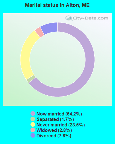
- Never married: 23.5%
- Now married: 64.2%
- Separated: 1.7%
- Widowed: 2.8%
- Divorced: 7.8%
For population 25 years and over in Alton:
- High school or higher: 83.0%
- Bachelor's degree or higher: 10.1%
- Graduate or professional degree: 2.8%
- Unemployed: 5.4%
- Mean travel time to work (commute): 24.4 minutes

| Here: | 9.1 |
| Maine average: | 11.2 |


Graphs represent county-level data. Detailed 2008 Election Results
Religion statistics for Alton, ME (based on Penobscot County data)


| Religion | Adherents | Congregations |
|---|---|---|
| Catholic | 16,581 | 15 |
| Mainline Protestant | 9,715 | 59 |
| Evangelical Protestant | 7,523 | 80 |
| Other | 2,936 | 22 |
| Orthodox | 300 | 1 |
| None | 116,868 | - |
Food Environment Statistics:
| Penobscot County: | 2.29 / 10,000 pop. |
| Maine: | 2.80 / 10,000 pop. |
| This county: | 0.13 / 10,000 pop. |
| State: | 0.14 / 10,000 pop. |
| Penobscot County: | 2.56 / 10,000 pop. |
| Maine: | 2.20 / 10,000 pop. |
| Penobscot County: | 5.72 / 10,000 pop. |
| State: | 5.75 / 10,000 pop. |
| Here: | 7.41 / 10,000 pop. |
| State: | 11.02 / 10,000 pop. |
| This county: | 9.0% |
| Maine: | 8.2% |
| Penobscot County: | 28.0% |
| Maine: | 25.0% |
Strongest AM radio stations in Alton:
- WZON (620 AM; 5 kW; BANGOR, ME; Owner: THE ZONE CORPORATION)
- WABI (910 AM; 5 kW; BANGOR, ME; Owner: CLEAR CHANNEL BROADCASTING LICENSES, INC.)
- WNZS (1340 AM; 1 kW; VEAZIE, ME; Owner: WATERFRONT COMMUNICATIONS INC.)
- WSKW (1160 AM; 10 kW; SKOWHEGAN, ME; Owner: MOUNTAIN WIRELESS, INCORPORATED)
- WDEA (1370 AM; 5 kW; ELLSWORTH, ME; Owner: CUMULUS LICENSING CORP.)
- WRKO (680 AM; 50 kW; BOSTON, MA; Owner: ENTERCOM BOSTON LICENSE, LLC)
- WTME (780 AM; 10 kW; RUMFORD, ME; Owner: MOUNTAIN VALLEY BROADCASTING, INC.)
- WEEI (850 AM; 50 kW; BOSTON, MA; Owner: ENTERCOM BOSTON LICENSE, LLC)
- WBZ (1030 AM; 50 kW; BOSTON, MA; Owner: INFINITY BROADCASTING OPERATIONS, INC.)
- WCRN (830 AM; 50 kW; WORCESTER, MA; Owner: CARTER BROADCASTING CORPORATION)
- WNNZ (640 AM; 50 kW; WESTFIELD, MA; Owner: CLEAR CHANNEL BROADCASTING LICENSES, INC.)
- WCHP (760 AM; 35 kW; CHAMPLAIN, NY; Owner: CHAMPLAIN RADIO, INC.)
- WKOX (1200 AM; 50 kW; FRAMINGHAM, MA; Owner: CAPSTAR TX LIMITED PARTNERSHIP)
Strongest FM radio stations in Alton:
- WBZN (107.3 FM; OLD TOWN, ME; Owner: CUMULUS LICENSING CORP.)
- WVOM (103.9 FM; HOWLAND, ME; Owner: CLEAR CHANNEL BROADCASTING LICENSES, INC.)
- WHCF (88.5 FM; BANGOR, ME; Owner: BANGOR BAPTIST CHURCH)
- WQCB (106.5 FM; BREWER, ME; Owner: CUMULUS LICENSING CORP.)
- WWBX (97.1 FM; BANGOR, ME; Owner: CLEAR CHANNEL BROADCASTING LICENSES, INC.)
- WMEH (90.9 FM; BANGOR, ME; Owner: MAINE PUBLIC BROADCASTING CORPORATION)
- WEZQ (92.9 FM; BANGOR, ME; Owner: CUMULUS LICENSING CORP.)
- WWMJ (95.7 FM; ELLSWORTH, ME; Owner: CUMULUS LICENSING CORP.)
- WKIT-FM (100.3 FM; BREWER, ME; Owner: THE ZONE CORPORATION)
- WBFB (104.7 FM; BELFAST, ME; Owner: CLEAR CHANNEL BROADCASTING LICENSES, INC.)
- WMEB-FM (91.9 FM; ORONO, ME; Owner: UNIVERSITY OF MAINE SYSTEM)
- WGUY (102.1 FM; DEXTER, ME; Owner: CONCORD MEDIA GROUP, INC.)
- WFZX (101.7 FM; SEARSPORT, ME; Owner: CLEAR CHANNEL BROADCASTING LICENSES, INC.)
- WHMX (105.7 FM; LINCOLN, ME; Owner: BANGOR BAPTIST CHURCH)
- WERU-FM (89.9 FM; BLUE HILL, ME; Owner: SALT POND COMMUNITY B/C COMPANY)
TV broadcast stations around Alton:
- WABI-TV (Channel 5; BANGOR, ME; Owner: COMMUNITY BROADCASTING SERVICE)
- WMEB-TV (Channel 12; ORONO, ME; Owner: MAINE PUBLIC BROADCASTING CORPORATION)
- WLBZ (Channel 2; BANGOR, ME; Owner: PACIFIC AND SOUTHERN COMPANY, INC.)
- WBGR-LP (Channel 33; BANGOR/DEDHAM, ME; Owner: MAINE FAMILY BROADCASTING, INC.)
- WCKD-LP (Channel 30; BANGOR/DEDHAM, ME; Owner: J. MCLEOD, ME FAMILY B/CING., INC.)
- W66CL (Channel 66; BANGOR, ME; Owner: MS COMMUNICATIONS, LLC)
Alton fatal accident list:
Nov 24, 2017 07:36 AM, Sr-16 Bennoch Rd, Lat: 45.084711, Lon: -68.779019, Vehicles: 2, Persons: 2, Fatalities: 1
Nov 23, 2012 05:25 AM, I-95, Lat: 45.097808, Lon: -68.692736, Vehicles: 1, Persons: 2, Fatalities: 1
Mar 7, 2010 10:00 PM, Sr-16, Lat: 44.905436, Lon: -68.684292, Vehicles: 1, Persons: 1, Fatalities: 1
May 26, 2008 01:17 PM, I-95, Lat: 45.033260, Lon: -68.692790, Vehicles: 1, Persons: 4, Fatalities: 2
Apr 28, 2006 01:56 PM, Sr-16, Lat: 45.110890, Lon: -68.809820, Vehicles: 2, Persons: 3, Fatalities: 1
- National Bridge Inventory (NBI) Statistics
- 5Number of bridges
- 39ft / 12.5mTotal length
- 8,682Total average daily traffic
- 431Total average daily truck traffic
- 12,579Total future (year 2036) average daily traffic
FCC Registered Antenna Towers:
13 (See the full list of FCC Registered Antenna Towers in Alton)FCC Registered Microwave Towers:
1- Alton, 27 Dolliff Road (Lat: 45.012611 Lon: -68.748389), Type: Gtower, Structure height: 103.6 m, Overall height: 104.9 m, Call Sign: WQTT331,
Assigned Frequencies: 10895.0 MHz, 10735.0 MHz, 10895.0 MHz, 10735.0 MHz, 10895.0 MHz, 10735.0 MHz, 10895.0 MHz, 10735.0 MHz, 10895.0 MHz, 10735.0 MHz... (+35 more), Grant Date: 04/08/2014, Expiration Date: 04/08/2024, Cancellation Date: 09/17/2020, Certifier: Jessica B Lyons, Registrant: At&t Mobility LLC, 208 S. Akard Street, Room 2100, Dallas, TX 75202, Phone: (855) 699-7073, Email:
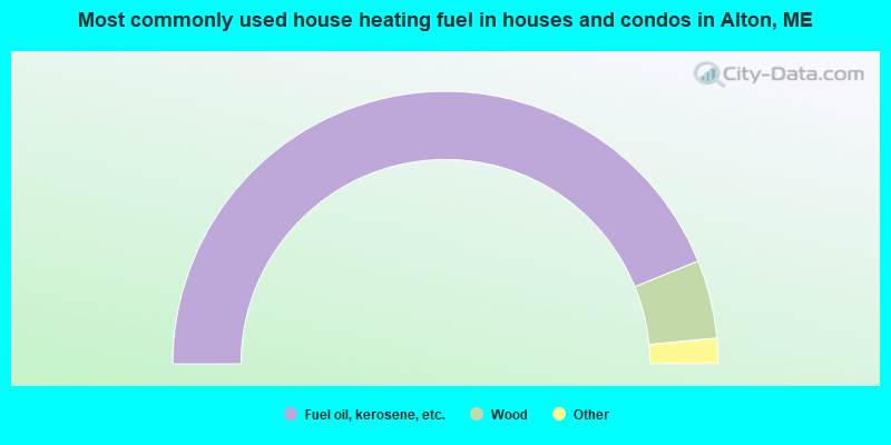
- 87.8%Fuel oil, kerosene, etc.
- 9.3%Wood
- 1.5%Coal or coke
- 0.7%Bottled, tank, or LP gas
- 0.7%Electricity
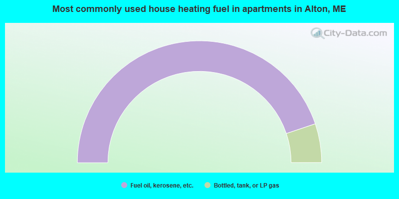
- 89.7%Fuel oil, kerosene, etc.
- 10.3%Bottled, tank, or LP gas
Alton compared to Maine state average:
- Median house value below state average.
- Unemployed percentage below state average.
- Black race population percentage significantly below state average.
- Hispanic race population percentage significantly below state average.
- Foreign-born population percentage significantly below state average.
- Renting percentage below state average.
- Length of stay since moving in significantly above state average.
- Number of rooms per house significantly below state average.
- House age significantly below state average.
- Percentage of population with a bachelor's degree or higher significantly below state average.