West End, Texas
Submit your own pictures of this place and show them to the world
- OSM Map
- General Map
- Google Map
- MSN Map

| Males: 1,822 | |
| Females: 1,783 |
| Median resident age: | 42.7 years |
| Texas median age: | 32.3 years |
Zip code: 78950
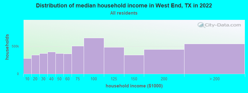
| West End: | $69,419 |
| TX: | $72,284 |
Estimated per capita income in 2022: $39,300 (it was $19,273 in 2000)
West End CCD income, earnings, and wages data
Estimated median house or condo value in 2022: $300,418 (it was $91,300 in 2000)
| West End: | $300,418 |
| TX: | $275,400 |
Detailed information about poverty and poor residents in West End, TX


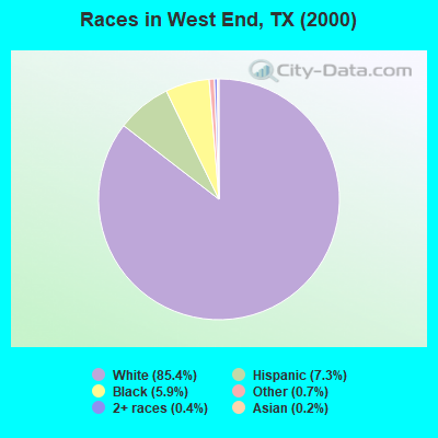
- 2,74385.4%White alone
- 2357.3%Hispanic
- 1885.9%Black alone
- 240.7%Other race alone
- 120.4%Two or more races
- 70.2%Asian alone
- 30.09%American Indian alone
Races in West End detailed stats: ancestries, foreign born residents, place of birth
 Recent articles from our blog. Our writers, many of them Ph.D. graduates or candidates, create easy-to-read articles on a wide variety of topics.
Current Local Time: CST time zone
Land area: 192.6 square miles.
Population density: 19 people per square mile (very low).

| West End CCD: | 0.9% ($866) |
| Texas: | 1.8% ($1,393) |
Nearest city with pop. 50,000+: College Station, TX  (45.9 miles , pop. 67,890).
Nearest city with pop. 200,000+: Northwest Harris, TX (55.0 miles , pop. 405,444).
Nearest city with pop. 1,000,000+: Houston, TX (67.1 miles , pop. 1,953,631).
Nearest cities:
Latitude: 29.95 N, Longitude: 96.48 W
Area code commonly used in this area: 979

| Here: | 3.2% |
| Texas: | 3.5% |
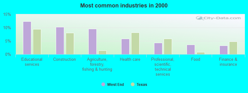
- Educational services (12.3%)
- Construction (10.3%)
- Agriculture, forestry, fishing & hunting (9.5%)
- Health care (5.8%)
- Professional, scientific, technical services (4.2%)
- Food (3.6%)
- Finance & insurance (3.3%)
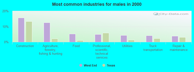
- Construction (15.6%)
- Agriculture, forestry, fishing & hunting (12.6%)
- Food (5.2%)
- Professional, scientific, technical services (4.9%)
- Utilities (4.3%)
- Truck transportation (4.2%)
- Repair & maintenance (3.9%)
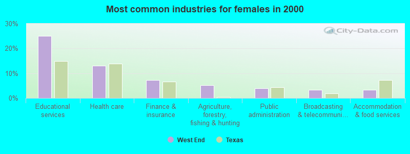
- Educational services (25.1%)
- Health care (13.1%)
- Finance & insurance (7.3%)
- Agriculture, forestry, fishing & hunting (5.1%)
- Public administration (3.9%)
- Broadcasting & telecommunications (3.3%)
- Accommodation & food services (3.3%)
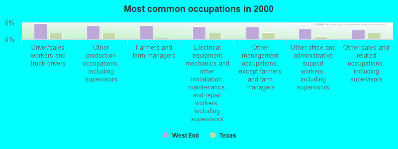
- Driver/sales workers and truck drivers (5.8%)
- Other production occupations, including supervisors (5.0%)
- Farmers and farm managers (5.0%)
- Electrical equipment mechanics and other installation, maintenance, and repair workers, including supervisors (4.8%)
- Other management occupations, except farmers and farm managers (4.6%)
- Other office and administrative support workers, including supervisors (3.8%)
- Other sales and related occupations, including supervisors (3.4%)
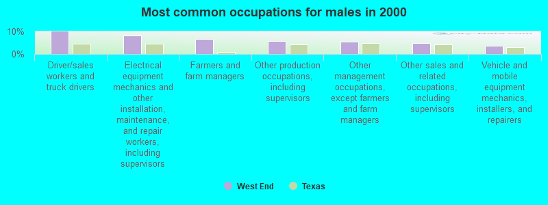
- Driver/sales workers and truck drivers (9.9%)
- Electrical equipment mechanics and other installation, maintenance, and repair workers, including supervisors (8.2%)
- Farmers and farm managers (6.6%)
- Other production occupations, including supervisors (5.7%)
- Other management occupations, except farmers and farm managers (5.4%)
- Other sales and related occupations, including supervisors (4.7%)
- Vehicle and mobile equipment mechanics, installers, and repairers (3.8%)
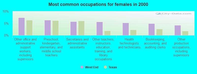
- Other office and administrative support workers, including supervisors (7.5%)
- Preschool, kindergarten, elementary, and middle school teachers (6.4%)
- Secretaries and administrative assistants (5.8%)
- Other teachers, instructors, education, training, and library occupations (5.7%)
- Health technologists and technicians (5.2%)
- Bookkeeping, accounting, and auditing clerks (4.9%)
- Other production occupations, including supervisors (4.2%)
Average climate in West End, Texas
Based on data reported by over 4,000 weather stations


(lower is better)
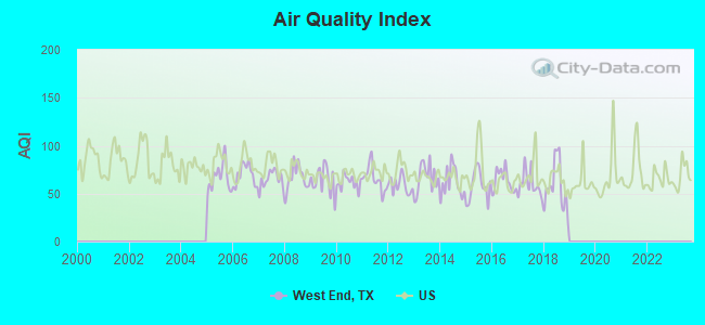
Air Quality Index (AQI) level in 2018 was 57.1. This is better than average.
| City: | 57.1 |
| U.S.: | 72.6 |
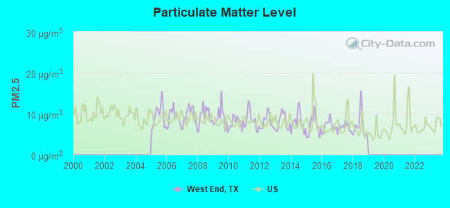
Particulate Matter (PM2.5) [µg/m3] level in 2018 was 7.06. This is about average. There were 0 monitors within city limits.
| City: | 7.06 |
| U.S.: | 8.11 |
Tornado activity:
West End-area historical tornado activity is near Texas state average. It is 46% greater than the overall U.S. average.
On 6/5/1950, a category F3 (max. wind speeds 158-206 mph) tornado 16.4 miles away from the West End place center injured 6 people and caused between $50,000 and $500,000 in damages.
On 3/20/1957, a category F3 tornado 29.4 miles away from the place center injured 2 people and caused between $5000 and $50,000 in damages.
Earthquake activity:
West End-area historical earthquake activity is significantly above Texas state average. It is 29% smaller than the overall U.S. average.On 10/20/2011 at 12:24:41, a magnitude 4.8 (4.8 MW, Depth: 3.1 mi, Class: Light, Intensity: IV - V) earthquake occurred 122.3 miles away from the city center
On 5/17/2012 at 08:12:00, a magnitude 4.8 (4.8 MW, Depth: 3.1 mi) earthquake occurred 185.1 miles away from West End center
On 4/9/1993 at 12:29:19, a magnitude 4.3 (4.1 MB, 4.3 LG, Depth: 3.1 mi) earthquake occurred 126.8 miles away from West End center
On 6/16/1978 at 11:46:54, a magnitude 5.3 (4.4 MB, 4.6 UK, 5.3 ML, Class: Moderate, Intensity: VI - VII) earthquake occurred 330.4 miles away from the city center
On 4/14/1995 at 00:32:56, a magnitude 5.7 (5.6 MB, 5.7 MS, 5.7 MW, Depth: 11.1 mi) earthquake occurred 412.7 miles away from West End center
On 5/1/2018 at 16:28:56, a magnitude 4.0 (4.0 MW, Depth: 3.1 mi) earthquake occurred 115.1 miles away from West End center
Magnitude types: regional Lg-wave magnitude (LG), body-wave magnitude (MB), local magnitude (ML), surface-wave magnitude (MS), moment magnitude (MW)
Natural disasters:
The number of natural disasters in Austin County (17) is near the US average (15).Major Disasters (Presidential) Declared: 8
Emergencies Declared: 7
Causes of natural disasters: Hurricanes: 7, Storms: 6, Floods: 5, Fires: 3, Tornadoes: 2, Wind: 1, Other: 1 (Note: some incidents may be assigned to more than one category).
Hospitals and medical centers near West End:
- SWEETBRIAR NURSING HOME (Nursing Home, about 12 miles away; BELLVILLE, TX)
- COLONIAL BELLE NURSING HOME (Nursing Home, about 13 miles away; BELLVILLE, TX)
- BELLVILLE GENERAL HOSPITAL Acute Care Hospitals (about 14 miles away; BELLVILLE, TX)
- BELLVILLE COMMUNITY RESIDENCE (Hospital, about 14 miles away; BELLVILLE, TX)
- LIBERTY DIALYSIS BRENHAM LLC (Dialysis Facility, about 15 miles away; BRENHAM, TX)
- BOHNE MEMORIAL HOSPITAL (Hospital, about 15 miles away; BRENHAM, TX)
- SCOTT & WHITE HOSPITAL BRENHAM Acute Care Hospitals (about 15 miles away; BRENHAM, TX)
Colleges/universities with over 2000 students nearest to West End:
- Blinn College (about 15 miles; Brenham, TX; Full-time enrollment: 8,959)
- Prairie View A & M University (about 31 miles; Prairie View, TX; FT enrollment: 7,517)
- Texas A & M University-College Station (about 47 miles; College Station, TX; FT enrollment: 46,550)
- Wharton County Junior College (about 50 miles; Wharton, TX; FT enrollment: 5,009)
- Houston Baptist University (about 61 miles; Houston, TX; FT enrollment: 2,340)
- Lone Star College System (about 62 miles; The Woodlands, TX; FT enrollment: 45,205)
- The Art Institute of Houston (about 64 miles; Houston, TX; FT enrollment: 2,429)
Points of interest:
Notable locations in West End: Gulf (A), Post Oak Point (B), Rock House (C), Welcome (D), Sachse Public Library (E), New Ulm Volunteer Fire Department (F), Bleiblerville Volunteer Fire Department (G), Witte-Schmid House (H), Roesler House (I). Display/hide their locations on the map
Churches in West End include: Welcome Church (A), Wesley Church (B), Cherry Chapel (C), Wesley Brethren Church (D), Goodwill Church (E). Display/hide their locations on the map
Cemeteries: Schmidt Cemetery (1), Scranton Grove Cemetery (2), Star Hill Cemetery (3), Zettel Cemetery (4), Kollatschny Cemetery (5), Knolle Cemetery (6), Hoppe Cemetery (7). Display/hide their locations on the map
Reservoirs: Butler Lake (A), Moore Lake (B). Display/hide their locations on the map
Streams, rivers, and creeks: Black Walnut Creek (A), Black Branch (B), Spring Branch (C), Skull Creek (D), Sandy Branch (E), East Mill Creek (F), Ward Branch (G), Sandy Creek (H), Rocky Branch (I). Display/hide their locations on the map
Parks in West End include: Harmonie Park (1), Historical Marker (2). Display/hide their locations on the map
| This place: | 2.5 people |
| Texas: | 2.7 people |
| This place: | 63.6% |
| Whole state: | 71.5% |
| This place: | 2.4% |
| Whole state: | 4.4% |
Likely homosexual households (counted as self-reported same-sex unmarried-partner households)
- Lesbian couples: 0.2% of all households
- Gay men: 0.3% of all households
| This place: | 11.7% |
| Whole state: | 15.4% |
| This place: | 4.1% |
| Whole state: | 6.7% |
For population 15 years and over in West End:
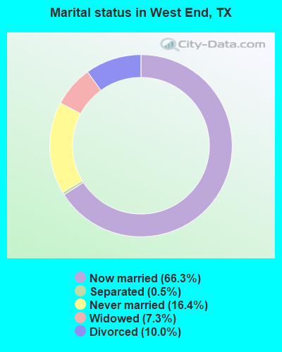
- Never married: 16.4%
- Now married: 66.3%
- Separated: 0.5%
- Widowed: 7.3%
- Divorced: 10.0%
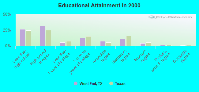
For population 25 years and over in West End:
- High school or higher: 73.6%
- Bachelor's degree or higher: 16.9%
- Graduate or professional degree: 5.6%
- Unemployed: 2.0%
- Mean travel time to work (commute): 27.8 minutes
| Here: | 15.2 |
| Texas average: | 15.6 |
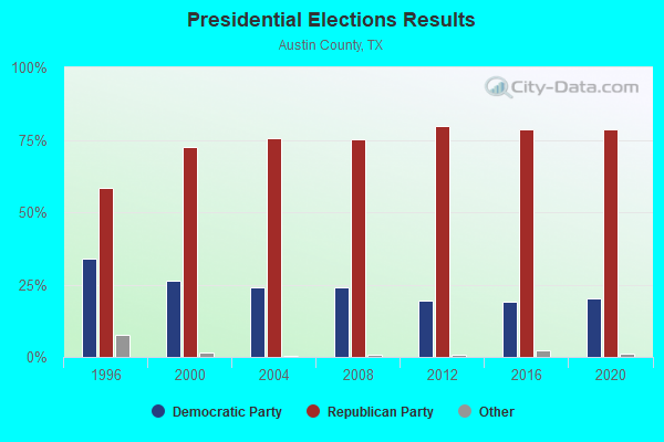
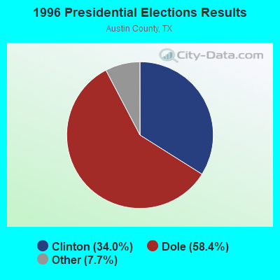
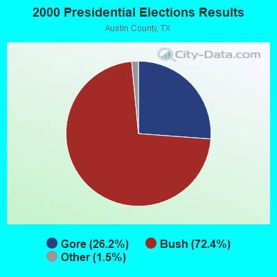

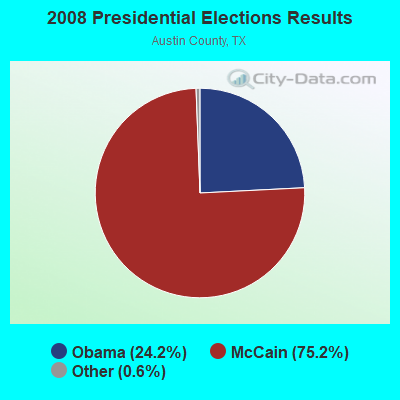
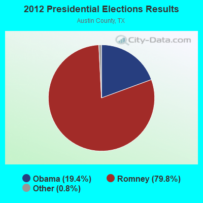
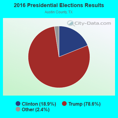
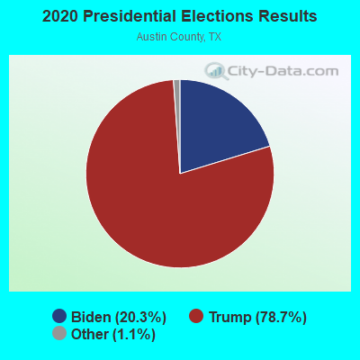
Graphs represent county-level data. Detailed 2008 Election Results
Religion statistics for West End, TX (based on Austin County data)
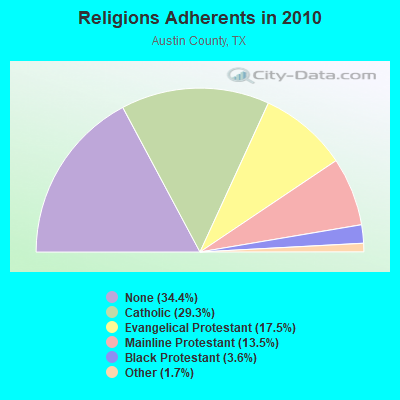
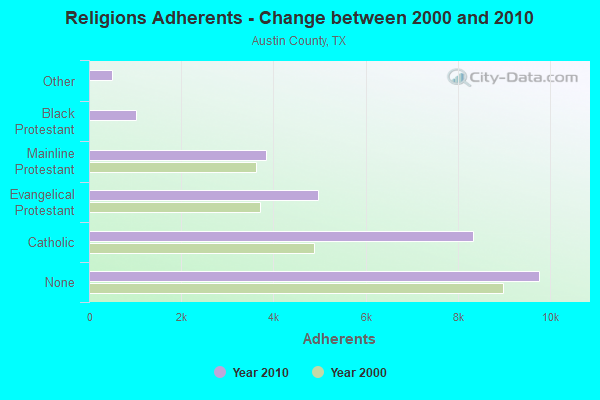
| Religion | Adherents | Congregations |
|---|---|---|
| Catholic | 8,333 | 5 |
| Evangelical Protestant | 4,965 | 25 |
| Mainline Protestant | 3,838 | 16 |
| Black Protestant | 1,018 | 6 |
| Other | 497 | 3 |
| None | 9,766 | - |
Food Environment Statistics:
| Austin County: | 1.51 / 10,000 pop. |
| Texas: | 1.47 / 10,000 pop. |
| This county: | 0.75 / 10,000 pop. |
| Texas: | 1.11 / 10,000 pop. |
| Here: | 4.90 / 10,000 pop. |
| Texas: | 3.95 / 10,000 pop. |
| Austin County: | 4.15 / 10,000 pop. |
| Texas: | 6.13 / 10,000 pop. |
| Austin County: | 9.9% |
| Texas: | 8.9% |
| This county: | 26.4% |
| State: | 26.6% |
| Austin County: | 12.1% |
| Texas: | 15.7% |
Strongest AM radio stations in West End:
- KGOL (1180 AM; 50 kW; HUMBLE, TX; Owner: ENTRAVISION HOLDINGS, LLC)
- KTRH (740 AM; 50 kW; HOUSTON, TX; Owner: AMFM TEXAS LICENSES LIMITED PARTNERSHIP)
- KSEV (700 AM; 15 kW; TOMBALL, TX; Owner: LIBERMAN BROADCASTING OF HOUSTON LICENSE CORP.)
- KILE (1560 AM; 50 kW; BELLAIRE, TX; Owner: THE RAFTT CORPORATION)
- KREH (900 AM; 5 kW; PECAN GROVE, TX)
- KTKR (760 AM; 50 kW; SAN ANTONIO, TX; Owner: CCB TEXAS LICENSES, L.P.)
- KEYH (850 AM; 10 kW; HOUSTON, TX; Owner: LIBERMAN BROADCASTING OF HOUSTON LICENSE CORP.)
- WOAI (1200 AM; 50 kW; SAN ANTONIO, TX; Owner: CCB TEXAS LICENSES, L.P.)
- KZNE (1150 AM; 10 kW; COLLEGE STATION, TX; Owner: BRYAN BROADCASTING LICENSE SUBSIDIARY, INC.)
- KWHI (1280 AM; 1 kW; BRENHAM, TX)
- KKYX (680 AM; 50 kW; SAN ANTONIO, TX; Owner: CXR HOLDINGS, INC.)
- WTAW (1620 AM; 10 kW; COLLEGE STATION, TX; Owner: BRYAN BROADCASTING LICENSE SUBSIDIARY, INC.)
- KKHT (1070 AM; 10 kW; HOUSTON, TX; Owner: SOUTH TEXAS BROADCASTING, INC.)
Strongest FM radio stations in West End:
- KNRG (92.3 FM; NEW ULM, TX; Owner: ROY E. HENDERSON TR/AS NEW ULM BROADCASTING CO.)
- K259AH (91.9 FM; BRENHAM, TX; Owner: THE KSBJ EDUCATIONAL FOUNDATION)
- KULF (94.1 FM; BRENHAM, TX; Owner: FORT BEND BROADCASTING COMPANY)
- KEZB (105.3 FM; HEMPSTEAD, TX; Owner: FARMERS COMMUNICATIONS)
- K216FD (91.1 FM; COLUMBUS, TX; Owner: FAMILY WORSHIP CENTER CHURCH, INC.)
- KULM-FM (98.3 FM; COLUMBUS, TX; Owner: ROY E. HENDERSON)
- KROX-FM (101.5 FM; BUDA, TX; Owner: EMMIS AUSTIN RADIO BROADCASTING COMPANY, L.P.)
- KTTX (106.1 FM; BRENHAM, TX; Owner: TOM S. WHITEHEAD, INC.)
- KBUK (104.9 FM; LA GRANGE, TX; Owner: FAYETTE BROADCASTING CORPORATION)
TV broadcast stations around West End:
- KBTX-TV (Channel 3; BRYAN, TX; Owner: KWTX-KBTX LICENSEE CORP.)
- K35DI (Channel 35; SOMERVILLE, TX; Owner: GERALD BENAVIDES)
- KYLE (Channel 28; BRYAN, TX; Owner: COMCORP OF BRYAN LICENSE CORP.)
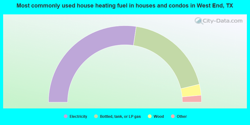
- 54.7%Electricity
- 37.8%Bottled, tank, or LP gas
- 4.6%Wood
- 1.5%Utility gas
- 1.1%Other fuel
- 0.4%Fuel oil, kerosene, etc.
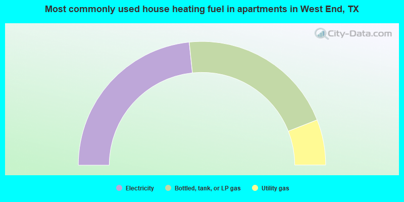
- 46.7%Electricity
- 41.4%Bottled, tank, or LP gas
- 11.9%Utility gas
West End compared to Texas state average:
- Unemployed percentage significantly below state average.
- Black race population percentage below state average.
- Hispanic race population percentage significantly below state average.
- Median age significantly above state average.
- Foreign-born population percentage significantly below state average.
- Renting percentage significantly below state average.
- Length of stay since moving in significantly above state average.
- Number of rooms per house significantly below state average.
- House age significantly below state average.
- Number of college students below state average.
West End on our top lists:
- #8 on the list of "Top 101 cities with the most residents born in Other Central America (population 500+)"