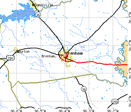
Brenham, Texas
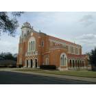
Brenham: St. Mary's Catholic Church, Brenham TX
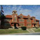
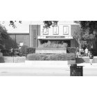
Brenham: Old Main Building, Blinn College
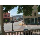
Brenham: Downtown Brenham
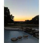
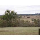
Brenham: Brenham sunset
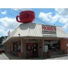
Brenham: Mobius Coffee House
Brenham: Academic Building, Blinn College
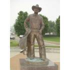
Brenham: Reese Blake Lockett, Mayor of Brenham
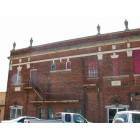
Brenham: Historical building
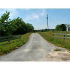
Brenham: country road, Brenham Texas
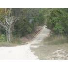
Brenham: Back roads in Brenham
Brenham: little Rocky Creek
- see
18
more - add
your
Submit your own pictures of this city and show them to the world
- OSM Map
- General Map
- Google Map
- MSN Map
Population change since 2000: +36.7%
 |
| Males: 8,539 | |
| Females: 9,930 |
| Median resident age: | 32.8 years |
| Texas median age: | 35.6 years |
Zip codes: 77833.
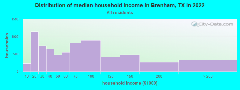
| Brenham: | $52,122 |
| TX: | $72,284 |
Estimated per capita income in 2022: $28,040 (it was $15,351 in 2000)
Brenham city income, earnings, and wages data
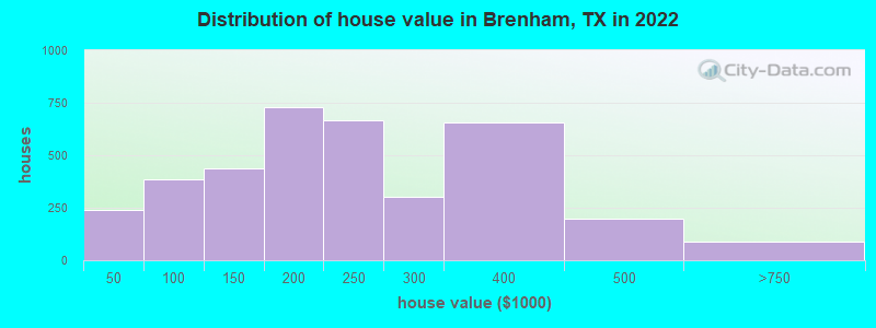
Estimated median house or condo value in 2022: $224,023 (it was $77,200 in 2000)
| Brenham: | $224,023 |
| TX: | $275,400 |
Mean prices in 2022: all housing units: $257,458; detached houses: $270,549; townhouses or other attached units: $343,048; mobile homes: $38,029
Median gross rent in 2022: $1,034.
(10.7% for White Non-Hispanic residents, 36.9% for Black residents, 8.2% for Hispanic or Latino residents, 25.7% for other race residents, 25.4% for two or more races residents)
Detailed information about poverty and poor residents in Brenham, TX

Compare current foreclosures near Brenham, TX:
| Photo | Address | Area | Beds / Baths | Price | Details |
|---|---|---|---|---|---|

|
#1
Autumn Rain Dr
Brenham, TX 77833
|
- sq. feet
|
2 baths 3 beds |
show details | |

|
#2
Burleson St
Brenham, TX 77833
|
- sq. feet
|
- baths - beds |
show details | |

|
#3
Old Independence Rd
Brenham, TX 77833
|
- sq. feet
|
- baths - beds |
show details | |

|
#4
Highway 290 W
Brenham, TX 77833
|
- sq. feet
|
- baths - beds |
show details | |

|
#5
Indian Trail Ln
Brenham, TX 77833
|
- sq. feet
|
- baths - beds |
show details | |

|
#6
Farmers Rd
Brenham, TX 77833
|
- sq. feet
|
- baths - beds |
show details | |

|
#7
Old Independence Rd
Brenham, TX 77833
|
- sq. feet
|
- baths - beds |
show details | |

|
#8
County Road 429
Somerville, TX 77879
|
- sq. feet
|
2 baths 4 beds |
show details | |

|
#9
Old Highway 36 Rd
Bellville, TX 77418
|
- sq. feet
|
- baths - beds |
show details | |

|
#10
Round House St
Somerville, TX 77879
|
- sq. feet
|
- baths - beds |
show details |
| Photo | Address | Area | Beds / Baths | Price | Details |
|---|---|---|---|---|---|

|
#11
Fm 1456 Rd
Bellville, TX 77418
|
- sq. feet
|
- baths - beds |
show details | |

|
#12
Conner Rd
Washington, TX 77880
|
- sq. feet
|
- baths - beds |
show details | |

|
#13
Mccraven School Rd
Washington, TX 77880
|
- sq. feet
|
- baths - beds |
show details | |

|
#14
Sweed Rd
Washington, TX 77880
|
- sq. feet
|
- baths - beds |
show details | |

|
#15
Egypt Ln
Washington, TX 77880
|
- sq. feet
|
- baths - beds |
show details | |

|
Check over 1 million property listings on Foreclosure.com!
|
browse all offers | |||


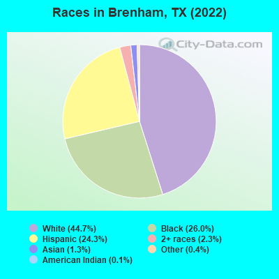
- 8,10944.7%White alone
- 4,71026.0%Black alone
- 4,40924.3%Hispanic
- 4172.3%Two or more races
- 2301.3%Asian alone
- 730.4%Other race alone
- 260.1%American Indian alone
Races in Brenham detailed stats: ancestries, foreign born residents, place of birth
According to our research of Texas and other state lists, there were 60 registered sex offenders living in Brenham, Texas as of May 01, 2024.
The ratio of all residents to sex offenders in Brenham is 285 to 1.
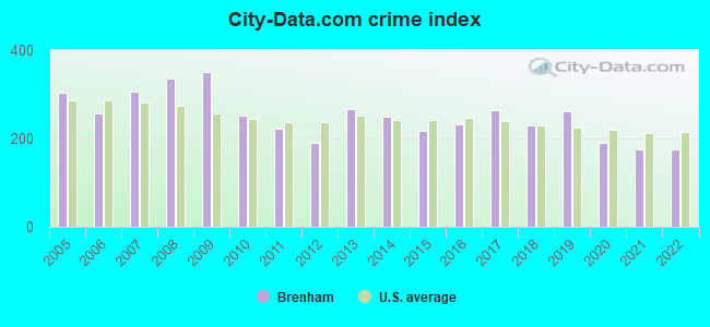
Type |
2009 |
2010 |
2011 |
2012 |
2013 |
2014 |
2015 |
2016 |
2017 |
2018 |
2019 |
2020 |
2021 |
2022 |
|---|---|---|---|---|---|---|---|---|---|---|---|---|---|---|
| Murders (per 100,000) | 0 (0.0) | 0 (0.0) | 1 (6.2) | 1 (6.3) | 1 (6.1) | 1 (6.2) | 0 (0.0) | 1 (6.0) | 1 (5.8) | 0 (0.0) | 0 (0.0) | 0 (0.0) | 0 (0.0) | 0 (0.0) |
| Rapes (per 100,000) | 1 (6.5) | 2 (12.7) | 5 (31.2) | 0 (0.0) | 11 (67.6) | 6 (37.1) | 11 (66.9) | 13 (77.7) | 7 (40.7) | 14 (81.8) | 15 (86.3) | 16 (88.4) | 6 (33.4) | 9 (47.9) |
| Robberies (per 100,000) | 12 (77.8) | 9 (57.3) | 6 (37.4) | 7 (43.8) | 10 (61.5) | 10 (61.8) | 11 (66.9) | 9 (53.8) | 3 (17.5) | 11 (64.3) | 6 (34.5) | 5 (27.6) | 6 (33.4) | 0 (0.0) |
| Assaults (per 100,000) | 91 (590.3) | 51 (324.5) | 31 (193.2) | 26 (162.6) | 46 (282.8) | 36 (222.4) | 24 (146.0) | 21 (125.5) | 115 (669.1) | 40 (233.7) | 72 (414.4) | 30 (165.7) | 72 (401.3) | 60 (319.4) |
| Burglaries (per 100,000) | 175 (1,135) | 113 (719.0) | 92 (573.3) | 86 (537.9) | 88 (540.9) | 110 (679.5) | 78 (474.6) | 92 (549.7) | 61 (354.9) | 49 (286.3) | 63 (362.6) | 37 (204.4) | 34 (189.5) | 42 (223.6) |
| Thefts (per 100,000) | 409 (2,653) | 386 (2,456) | 338 (2,106) | 339 (2,120) | 330 (2,029) | 358 (2,212) | 291 (1,771) | 264 (1,577) | 200 (1,164) | 298 (1,741) | 276 (1,588) | 253 (1,397) | 160 (891.9) | 203 (1,081) |
| Auto thefts (per 100,000) | 34 (220.6) | 22 (140.0) | 19 (118.4) | 19 (118.8) | 12 (73.8) | 19 (117.4) | 22 (133.9) | 34 (203.2) | 23 (133.8) | 20 (116.8) | 22 (126.6) | 18 (99.4) | 22 (122.6) | 32 (170.3) |
| Arson (per 100,000) | 0 (0.0) | 1 (6.4) | 2 (12.5) | 1 (6.3) | 4 (24.6) | 15 (92.7) | 4 (24.3) | 0 (0.0) | 0 (0.0) | 2 (11.7) | 1 (5.8) | 0 (0.0) | 0 (0.0) | 0 (0.0) |
| City-Data.com crime index | 349.9 | 252.0 | 221.1 | 190.1 | 266.3 | 250.4 | 217.6 | 233.2 | 265.4 | 230.5 | 261.4 | 190.3 | 175.8 | 174.7 |
The City-Data.com crime index weighs serious crimes and violent crimes more heavily. Higher means more crime, U.S. average is 246.1. It adjusts for the number of visitors and daily workers commuting into cities.
Crime rate in Brenham detailed stats: murders, rapes, robberies, assaults, burglaries, thefts, arson
Full-time law enforcement employees in 2021, including police officers: 41 (36 officers - 30 male; 6 female).
| Officers per 1,000 residents here: | 2.01 |
| Texas average: | 2.07 |
 Recent articles from our blog. Our writers, many of them Ph.D. graduates or candidates, create easy-to-read articles on a wide variety of topics.

 | Texas being excluded from the South (743 replies) |
| Brenham ISD vs. College Station ISD (2 replies) |
| Day trips or attractions/things to do near Houston (24 replies) |
| Westward Expansion (198 replies) |
| Deregulated power - what's the point? (92 replies) |
| Houston Area Grocery Stores (20 replies) |
Latest news from Brenham, TX collected exclusively by city-data.com from local newspapers, TV, and radio stations
Ancestries: German (14.6%), American (6.7%), Irish (3.0%), English (2.2%), Polish (1.4%), Scotch-Irish (1.1%).
Current Local Time: CST time zone
Land area: 8.76 square miles.
Population density: 2,108 people per square mile (low).
980 residents are foreign born (4.0% Latin America, 1.0% Asia).
| This city: | 5.4% |
| Texas: | 17.1% |
Median real estate property taxes paid for housing units with mortgages in 2022: $3,507 (1.4%)
Median real estate property taxes paid for housing units with no mortgage in 2022: $1,855 (0.9%)
Nearest city with pop. 50,000+: College Station, TX  (30.8 miles , pop. 67,890).
Nearest city with pop. 200,000+: Northwest Harris, TX (50.9 miles , pop. 405,444).
Nearest city with pop. 1,000,000+: Houston, TX (66.7 miles , pop. 1,953,631).
Nearest cities:
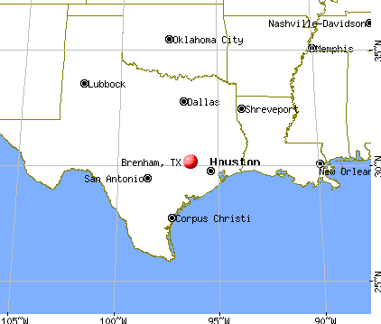
), ), Latitude: 30.16 N, Longitude: 96.40 W
Daytime population change due to commuting: +7,245 (+40.0%)
Workers who live and work in this city: 5,740 (75.3%)
Area code: 979
Brenham tourist attractions:
Brenham, Texas accommodation & food services, waste management - Economy and Business Data
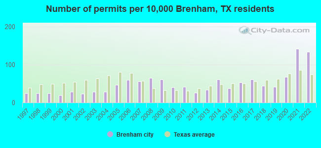
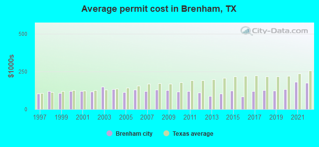
Single-family new house construction building permits:
- 2022: 181 buildings, average cost: $176,500
- 2021: 190 buildings, average cost: $180,500
- 2020: 90 buildings, average cost: $134,700
- 2019: 55 buildings, average cost: $123,500
- 2018: 59 buildings, average cost: $127,700
- 2017: 83 buildings, average cost: $120,400
- 2016: 72 buildings, average cost: $83,600
- 2015: 51 buildings, average cost: $125,000
- 2014: 83 buildings, average cost: $103,500
- 2013: 46 buildings, average cost: $88,900
- 2012: 35 buildings, average cost: $110,000
- 2011: 56 buildings, average cost: $119,700
- 2010: 54 buildings, average cost: $118,300
- 2009: 82 buildings, average cost: $125,800
- 2008: 88 buildings, average cost: $131,300
- 2007: 75 buildings, average cost: $121,700
- 2006: 80 buildings, average cost: $130,500
- 2005: 64 buildings, average cost: $115,400
- 2004: 39 buildings, average cost: $133,700
- 2003: 38 buildings, average cost: $150,700
- 2002: 31 buildings, average cost: $117,200
- 2001: 38 buildings, average cost: $122,200
- 2000: 26 buildings, average cost: $120,500
- 1999: 33 buildings, average cost: $106,900
- 1998: 32 buildings, average cost: $120,900
- 1997: 34 buildings, average cost: $104,800
| Here: | 3.5% |
| Texas: | 3.5% |
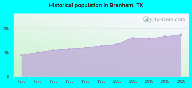
Population change in the 1990s: +1,352 (+11.1%).
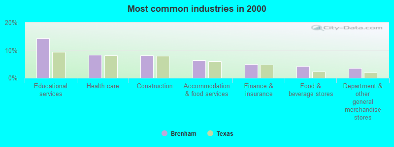
- Educational services (14.3%)
- Health care (8.3%)
- Construction (8.2%)
- Accommodation & food services (6.3%)
- Finance & insurance (4.9%)
- Food & beverage stores (4.2%)
- Department & other general merchandise stores (3.6%)
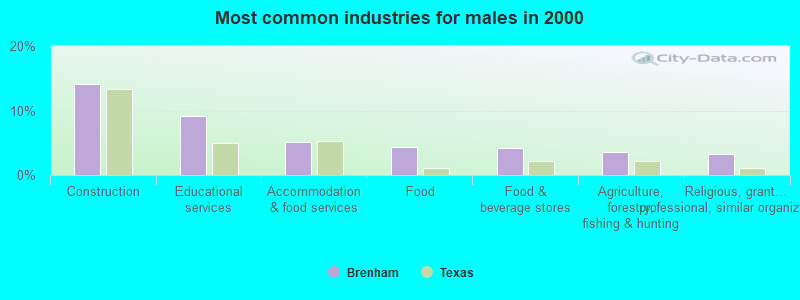
- Construction (14.1%)
- Educational services (9.1%)
- Accommodation & food services (5.1%)
- Food (4.4%)
- Food & beverage stores (4.2%)
- Agriculture, forestry, fishing & hunting (3.5%)
- Religious, grantmaking, civic, professional, similar organizations (3.3%)
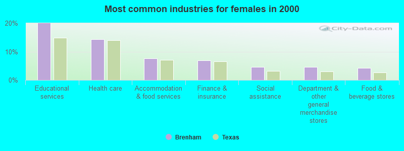
- Educational services (20.0%)
- Health care (14.3%)
- Accommodation & food services (7.6%)
- Finance & insurance (7.0%)
- Social assistance (4.6%)
- Department & other general merchandise stores (4.6%)
- Food & beverage stores (4.2%)
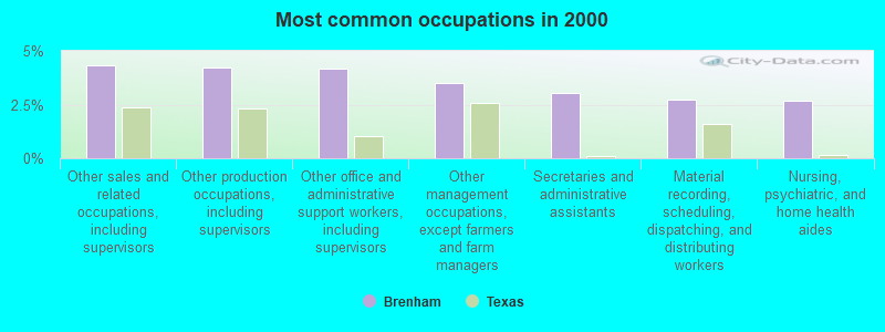
- Other sales and related occupations, including supervisors (4.3%)
- Other production occupations, including supervisors (4.2%)
- Other office and administrative support workers, including supervisors (4.2%)
- Other management occupations, except farmers and farm managers (3.5%)
- Secretaries and administrative assistants (3.1%)
- Material recording, scheduling, dispatching, and distributing workers (2.7%)
- Nursing, psychiatric, and home health aides (2.7%)
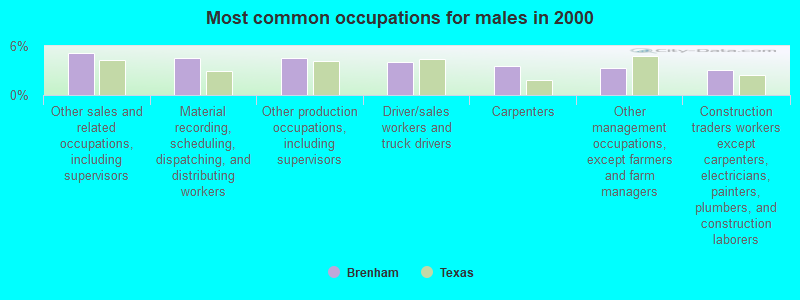
- Other sales and related occupations, including supervisors (5.1%)
- Material recording, scheduling, dispatching, and distributing workers (4.5%)
- Other production occupations, including supervisors (4.5%)
- Driver/sales workers and truck drivers (4.0%)
- Carpenters (3.5%)
- Other management occupations, except farmers and farm managers (3.3%)
- Construction traders workers except carpenters, electricians, painters, plumbers, and construction laborers (3.1%)
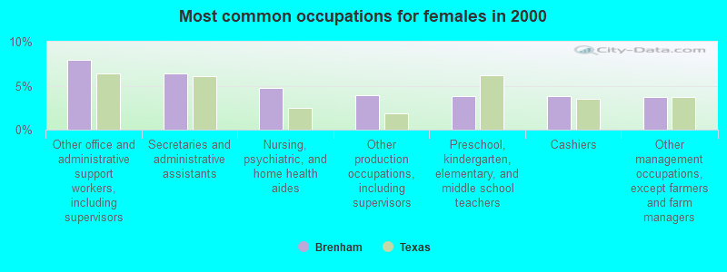
- Other office and administrative support workers, including supervisors (8.0%)
- Secretaries and administrative assistants (6.4%)
- Nursing, psychiatric, and home health aides (4.8%)
- Other production occupations, including supervisors (3.9%)
- Preschool, kindergarten, elementary, and middle school teachers (3.8%)
- Cashiers (3.8%)
- Other management occupations, except farmers and farm managers (3.8%)
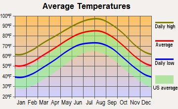
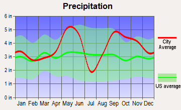
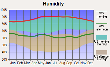
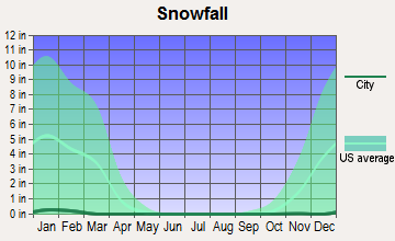
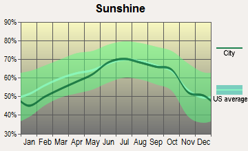
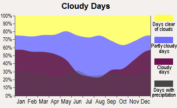
Average climate in Brenham, Texas
Based on data reported by over 4,000 weather stations

|
|


Tornado activity:
Brenham-area historical tornado activity is near Texas state average. It is 45% greater than the overall U.S. average.
On 6/5/1950, a category F3 (max. wind speeds 158-206 mph) tornado 1.3 miles away from the Brenham city center injured 6 people and caused between $50,000 and $500,000 in damages.
On 3/10/2000, a category F3 tornado 16.7 miles away from the city center injured 2 people and caused $1 million in damages.
Earthquake activity:
Brenham-area historical earthquake activity is significantly above Texas state average. It is 26% smaller than the overall U.S. average.On 10/20/2011 at 12:24:41, a magnitude 4.8 (4.8 MW, Depth: 3.1 mi, Class: Light, Intensity: IV - V) earthquake occurred 135.3 miles away from Brenham center
On 5/17/2012 at 08:12:00, a magnitude 4.8 (4.8 MW, Depth: 3.1 mi) earthquake occurred 171.3 miles away from Brenham center
On 6/16/1978 at 11:46:54, a magnitude 5.3 (4.4 MB, 4.6 UK, 5.3 ML, Class: Moderate, Intensity: VI - VII) earthquake occurred 324.9 miles away from the city center
On 4/9/1993 at 12:29:19, a magnitude 4.3 (4.1 MB, 4.3 LG, Depth: 3.1 mi) earthquake occurred 139.8 miles away from the city center
On 4/14/1995 at 00:32:56, a magnitude 5.7 (5.6 MB, 5.7 MS, 5.7 MW, Depth: 11.1 mi) earthquake occurred 416.6 miles away from the city center
On 9/2/2013 at 23:51:15, a magnitude 4.3 (4.3 MW, Depth: 2.9 mi) earthquake occurred 168.0 miles away from the city center
Magnitude types: regional Lg-wave magnitude (LG), body-wave magnitude (MB), local magnitude (ML), surface-wave magnitude (MS), moment magnitude (MW)
Natural disasters:
The number of natural disasters in Washington County (13) is near the US average (15).Major Disasters (Presidential) Declared: 6
Emergencies Declared: 5
Causes of natural disasters: Hurricanes: 5, Floods: 4, Storms: 4, Fires: 3, Tornado: 1, Wind: 1, Other: 1 (Note: some incidents may be assigned to more than one category).
Hospitals in Brenham:
- BOHNE MEMORIAL HOSPITAL (provides emergency services, 700 MEDICAL PKWY)
- BRENHAM STATE SCHOOL (HIGHWAY 36 SOUTH)
- SCOTT & WHITE HOSPITAL BRENHAM (Voluntary non-profit - Private, 700 MEDICAL PARKWAY)
Nursing Homes in Brenham:
- BLUEBONNET HILLS CARE CENTER (401 EAST BLUE BELL ROAD)
- BRENHAM NURSING AND REHABILITATION CENTER (400 SAYLES ST)
- BRENHAM REST HOME (406 COTTONWOOD ST)
- E F AND BERTHA KRUSE MEMORIAL LUTHERAN VILLAGE (1700 E STONE ST)
- SWEETBRIAR NURSING HOME BRENHAM INC (401 E HORTON ST)
Dialysis Facilities in Brenham:
Home Health Centers in Brenham:
Airports located in Brenham:
- Brenham Municipal Airport (11R) (Runways: 1, Itinerant Ops: 5,000, Local Ops: 10,000, Military Ops: 50)
- K Star Ranch Airport (49TE) (Runways: 1)
- Live Oak Ranch Airport (TA17) (Runways: 1)
- Lucky Star Ranch Airport (TX04) (Runways: 1)
- Rancho Verde Airport (9XS9) (Runways: 1)
- Sky Lane Ranch Airport (XS68) (Runways: 1)
College/University in Brenham:
Other colleges/universities with over 2000 students near Brenham:
- Prairie View A & M University (about 25 miles; Prairie View, TX; Full-time enrollment: 7,517)
- Texas A & M University-College Station (about 32 miles; College Station, TX; FT enrollment: 46,550)
- Lone Star College System (about 55 miles; The Woodlands, TX; FT enrollment: 45,205)
- Universal Technical Institute of Texas Inc. (about 61 miles; Houston, TX; FT enrollment: 3,236)
- Wharton County Junior College (about 61 miles; Wharton, TX; FT enrollment: 5,009)
- Houston Baptist University (about 62 miles; Houston, TX; FT enrollment: 2,340)
- Sam Houston State University (about 64 miles; Huntsville, TX; FT enrollment: 16,233)
Public high schools in Brenham:
- BRENHAM H S (Students: 650, Location: 525 A H EHRIG DR, Grades: 9-12)
- PRIDE ACADEMY (Location: 1301 S MARKET, Grades: 11-12)
Private high school in Brenham:
Public elementary/middle schools in Brenham:
- BRENHAM J H (Students: 1,413, Location: 1200 CARLEE DR, Grades: 7-8)
- BRENHAM EL (Students: 822, Location: 1000 BLUE BELL DR, Grades: PK-4)
- KRAUSE EL (Students: 713, Location: 2201 E STONE, Grades: PK-4)
- BRENHAM MIDDLE (Students: 688, Location: 1600 S BLUE BELL RD, Grades: 5-6)
- ALTON EL (Location: 1210 S MARKET ST, Grades: PK-4)
Private elementary/middle schools in Brenham:
User-submitted facts and corrections:
- Correct link for Blinn College is http://www.blinn.edu
Points of interest:
Notable locations in Brenham: East Brenham Historict District (A), Santa Fe Railway Company Freight Depot (B), Southern Pacific Railroad Freight Depot (C), Brenham Water Works (D), Edmund Holle House (E), Edgar Matchett House (F), F W Schuerenberg House (G), Giddings-Wilkin House (H), Giddings-Stone Mansion (I), Giddings-Wilkin House Museum (J), Brenham Fire Department (K), Washington County Emergency Medical Services (L), Doctor Robert Lenert House (M), Brockschmidt-Miller House (N), Blue Bell Creameries Complex (O), Brenham High School Gymnasium (P), Becker-Hildebrandt House (Q), Bassett and Bassett Banking House (R), Almot Schlenker House (S), Reichardt-Low House (T). Display/hide their locations on the map
Churches in Brenham include: Saint Marys Catholic Church (A), Synagogue B'nai Abraham (B), Mount Zion Methodist Church (C). Display/hide their locations on the map
Cemeteries: Calvary Cemetery (1), Camptown Cemetery (2), Prairie Lea Cemetery (3), HIC Cemetery (4), Willow Grove Cemetery (5). Display/hide their locations on the map
Parks in Brenham include: Jackson Park (1), Hattie Powers Park (2), Brenham Sports Complex (3), Firemans Park (4). Display/hide their locations on the map
Tourist attraction: Brenham Heritage Museum (105 South Market Street).
Hotels: Coach Light Inn (2242 South Market Street), Bed & Breakfast-The Inn at Nueces Canyon (9501 Highway 290 West), Ant Street Inn (107 West Commerce Street), Best Western Inn Of Brenham (1503 Highway 290 E).
Birthplace of: Cecil Cooper - Baseball player and coach, H. Scott Hughes - Film director, Jack Heidemann - Baseball player, Limas Sweed - Football player, Roderick Green - 2005 NFL player (Baltimore Ravens, born: Apr 26, 1982), William Ezell - Blues, Chuck Machemehl - Baseball player, Cleveland Franklin - Football player, Gary Weiss (baseball) - Baseball player, Gil Steinke - Football player.
Drinking water stations with addresses in Brenham and their reported violations in the past:
MONAVILLE COUNTRY GRILL GROCERY (Population served: 25, Groundwater):Past monitoring violations:
- 5 routine major monitoring violations
| This city: | 2.4 people |
| Texas: | 2.8 people |
| This city: | 61.3% |
| Whole state: | 69.9% |
| This city: | 5.0% |
| Whole state: | 6.0% |
Likely homosexual households (counted as self-reported same-sex unmarried-partner households)
- Lesbian couples: 0.2% of all households
- Gay men: 0.2% of all households
People in group quarters in Brenham in 2010:
- 941 people in college/university student housing
- 369 people in nursing facilities/skilled-nursing facilities
- 257 people in state prisons
- 91 people in workers' group living quarters and job corps centers
- 80 people in local jails and other municipal confinement facilities
- 49 people in group homes intended for adults
- 14 people in emergency and transitional shelters (with sleeping facilities) for people experiencing homelessness
- 7 people in residential schools for people with disabilities
- 4 people in residential treatment centers for adults
People in group quarters in Brenham in 2000:
- 723 people in college dormitories (includes college quarters off campus)
- 473 people in schools, hospitals, or wards for the intellectually disabled
- 402 people in nursing homes
- 72 people in local jails and other confinement facilities (including police lockups)
- 17 people in other group homes
- 15 people in other noninstitutional group quarters
- 12 people in homes for the mentally retarded
- 2 people in religious group quarters
Banks with branches in Brenham (2011 data):
- Wells Fargo Bank, National Association: Brenham Convenience Center Branch, Brenham Main Branch, Brenham Off-Site Banking Branch, Tx-Washington County 1 Branch. Info updated 2011/04/05: Bank assets: $1,161,490.0 mil, Deposits: $905,653.0 mil, headquarters in Sioux Falls, SD, positive income, 6395 total offices, Holding Company: Wells Fargo & Company
- JPMorgan Chase Bank, National Association: Brenham Main Branch at 303 North Market Street, branch established on 1883/07/11. Info updated 2011/11/10: Bank assets: $1,811,678.0 mil, Deposits: $1,190,738.0 mil, headquarters in Columbus, OH, positive income, International Specialization, 5577 total offices, Holding Company: Jpmorgan Chase & Co.
- Bank of Brenham, National Association: Bank Of Brenham, National Association at 501 South Austin Street, branch established on 2001/08/07. Info updated 2006/11/03: Bank assets: $93.3 mil, Deposits: $84.0 mil, local headquarters, positive income, 1 total offices
- Citizens State Bank: Brenham Branch at 2007 South Day, branch established on 1999/01/04. Info updated 2007/03/20: Bank assets: $384.5 mil, Deposits: $350.4 mil, headquarters in Somerville, TX, positive income, 6 total offices, Holding Company: C.S.b. Bancshares, Inc.
- Capital One, National Association: Brenham Branch at 301 East Main Street, branch established on 1960/10/21. Info updated 2011/07/01: Bank assets: $133,477.8 mil, Deposits: $97,063.7 mil, headquarters in Mclean, VA, positive income, 984 total offices, Holding Company: Capital One Financial Corporation
- Compass Bank: Brenham Branch at 2000 South Market Street, branch established on 1989/09/21. Info updated 2011/02/24: Bank assets: $63,107.0 mil, Deposits: $46,232.4 mil, headquarters in Birmingham, AL, negative income in the last year, Commercial Lending Specialization, 720 total offices, Holding Company: Banco Bilbao Vizcaya Argentaria, S.A.
- The Brenham National Bank: at 2211 South Day Street, branch established on 1933/04/22. Info updated 2008/12/09: Bank assets: $272.5 mil, Deposits: $234.3 mil, local headquarters, positive income, Commercial Lending Specialization, 3 total offices, Holding Company: Brenham Bancshares, Inc.
- Woodforest National Bank: Brenham Walmart Branch at 203 Us Loop 290 West, branch established on 2005/08/10. Info updated 2011/05/10: Bank assets: $3,488.9 mil, Deposits: $3,097.6 mil, headquarters in Houston, TX, positive income, Commercial Lending Specialization, 766 total offices, Holding Company: Woodforest Financial Group Employee Stock Ownership Plan (With 401(K) Provisions)
For population 15 years and over in Brenham:
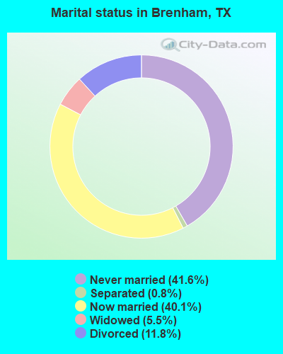
- Never married: 41.6%
- Now married: 40.1%
- Separated: 0.8%
- Widowed: 5.5%
- Divorced: 11.8%
For population 25 years and over in Brenham:
- High school or higher: 86.5%
- Bachelor's degree or higher: 28.3%
- Graduate or professional degree: 8.7%
- Unemployed: 5.1%
- Mean travel time to work (commute): 16.6 minutes
| Here: | 12.1 |
| Texas average: | 14.0 |
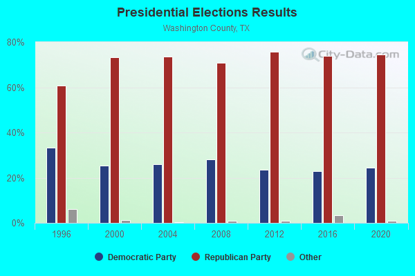
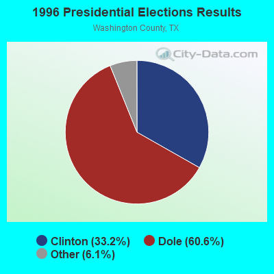
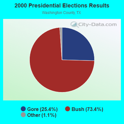

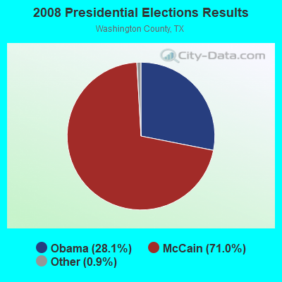
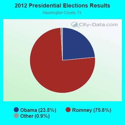
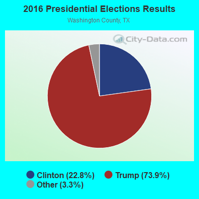
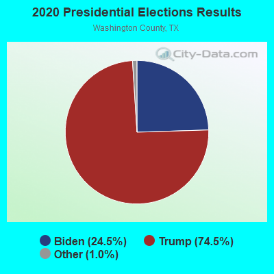
Graphs represent county-level data. Detailed 2008 Election Results
Religion statistics for Brenham, TX (based on Washington County data)
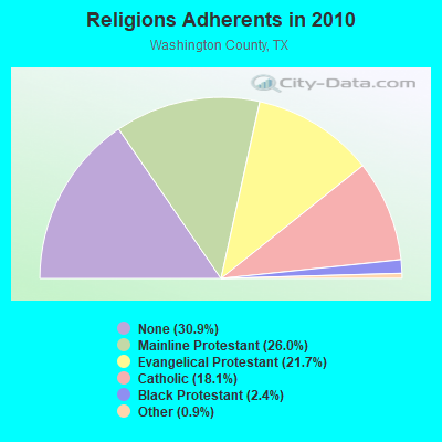
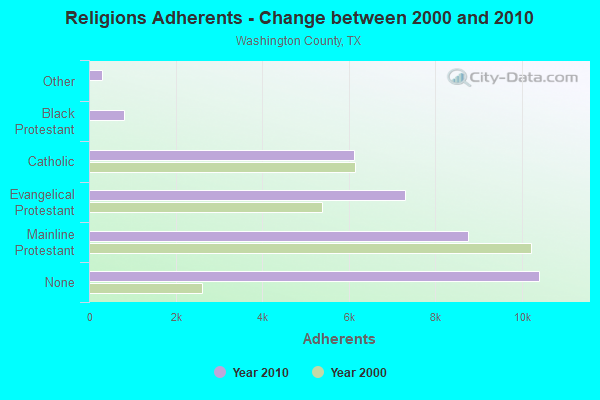
| Religion | Adherents | Congregations |
|---|---|---|
| Mainline Protestant | 8,765 | 22 |
| Evangelical Protestant | 7,300 | 38 |
| Catholic | 6,112 | 3 |
| Black Protestant | 817 | 6 |
| Other | 310 | 2 |
| Orthodox | 6 | 1 |
| None | 10,408 | - |
Food Environment Statistics:
| Washington County: | 1.88 / 10,000 pop. |
| Texas: | 1.47 / 10,000 pop. |
| Here: | 0.31 / 10,000 pop. |
| Texas: | 0.14 / 10,000 pop. |
| Washington County: | 0.94 / 10,000 pop. |
| Texas: | 1.11 / 10,000 pop. |
| Washington County: | 7.20 / 10,000 pop. |
| State: | 3.95 / 10,000 pop. |
| This county: | 10.02 / 10,000 pop. |
| State: | 6.13 / 10,000 pop. |
| Here: | 11.7% |
| Texas: | 8.9% |
| This county: | 29.8% |
| Texas: | 26.6% |
| This county: | 12.9% |
| State: | 15.7% |
Health and Nutrition:
| This city: | 48.4% |
| State: | 48.6% |
| Brenham: | 44.4% |
| State: | 47.4% |
| Here: | 28.8 |
| Texas: | 28.5 |
| Brenham: | 20.1% |
| Texas: | 20.6% |
| This city: | 13.0% |
| Texas: | 10.3% |
| This city: | 6.8 |
| Texas: | 6.8 |
| This city: | 33.0% |
| State: | 33.1% |
| Brenham: | 54.0% |
| Texas: | 56.2% |
| Here: | 78.0% |
| Texas: | 80.7% |
More about Health and Nutrition of Brenham, TX Residents
| Local government employment and payroll (March 2022) | |||||
| Function | Full-time employees | Monthly full-time payroll | Average yearly full-time wage | Part-time employees | Monthly part-time payroll |
|---|---|---|---|---|---|
| Other and Unallocable | 33 | $174,592 | $63,488 | 11 | $10,232 |
| Police Protection - Officers | 33 | $198,718 | $72,261 | 0 | $0 |
| Financial Administration | 24 | $117,022 | $58,511 | 1 | $2,338 |
| Sewerage | 21 | $53,618 | $30,639 | 0 | $0 |
| Parks and Recreation | 16 | $59,727 | $44,795 | 28 | $18,262 |
| Firefighters | 13 | $74,733 | $68,984 | 0 | $0 |
| Streets and Highways | 11 | $38,429 | $41,923 | 0 | $0 |
| Electric Power | 11 | $60,565 | $66,071 | 0 | $0 |
| Water Supply | 10 | $32,789 | $39,347 | 0 | $0 |
| Other Government Administration | 10 | $65,166 | $78,199 | 7 | $2,715 |
| Police - Other | 6 | $34,978 | $69,956 | 0 | $0 |
| Gas Supply | 6 | $30,087 | $60,174 | 0 | $0 |
| Health | 5 | $17,438 | $41,851 | 0 | $0 |
| Judicial and Legal | 5 | $15,263 | $36,631 | 2 | $4,452 |
| Local Libraries | 4 | $16,606 | $49,818 | 4 | $4,595 |
| Fire - Other | 3 | $10,019 | $40,076 | 0 | $0 |
| Totals for Government | 211 | $999,751 | $56,858 | 53 | $42,594 |
Brenham government finances - Expenditure in 2021 (per resident):
- Construction - Parks and Recreation: $157,000 ($8.50)
- Current Operations - Police Protection: $3,376,000 ($182.79)
General Public Buildings: $1,756,000 ($95.08)
Judicial and Legal Services: $362,000 ($19.60)
Local Fire Protection: $34,000 ($1.84)
- General - Interest on Debt: $205,000 ($11.10)
- Other Capital Outlay - General Public Building: $16,000 ($0.87)
- Total Salaries and Wages: $1,633,000 ($88.42)
Brenham government finances - Revenue in 2021 (per resident):
- Miscellaneous - Fines and Forfeits: $627,000 ($33.95)
Interest Earnings: $29,000 ($1.57)
General Revenue - Other: $15,000 ($0.81)
- State Intergovernmental - Other: $134,000 ($7.26)
- Tax - General Sales and Gross Receipts: $1,402,000 ($75.91)
Property: $1,132,000 ($61.29)
Public Utilities Sales: $930,000 ($50.35)
Other License: $18,000 ($0.97)
Brenham government finances - Debt in 2021 (per resident):
- Long Term Debt - Outstanding Unspecified Public Purpose: $4,936,000 ($267.26)
Beginning Outstanding - Unspecified Public Purpose: $4,936,000 ($267.26)
Brenham government finances - Cash and Securities in 2021 (per resident):
- Other Funds - Cash and Securities: $5,086,000 ($275.38)
- Sinking Funds - Cash and Securities: $99,000 ($5.36)
| Businesses in Brenham, TX | ||||
| Name | Count | Name | Count | |
|---|---|---|---|---|
| AT&T | 1 | La Quinta | 1 | |
| Ace Hardware | 1 | La-Z-Boy | 1 | |
| Applebee's | 1 | Little Caesars Pizza | 1 | |
| AutoZone | 1 | Lowe's | 1 | |
| Best Western | 1 | Maurices | 1 | |
| Blockbuster | 1 | McDonald's | 2 | |
| Burger King | 1 | Nike | 2 | |
| CVS | 1 | Payless | 1 | |
| Chevrolet | 1 | Penske | 1 | |
| Church's Chicken | 1 | Pizza Hut | 1 | |
| Cinnabon | 1 | Quiznos | 1 | |
| Comfort Suites | 1 | RadioShack | 1 | |
| Curves | 1 | Rodeway Inn | 1 | |
| Dairy Queen | 1 | SONIC Drive-In | 2 | |
| Dennys | 1 | Sears | 1 | |
| Discount Tire | 1 | Starbucks | 1 | |
| FedEx | 4 | Subway | 3 | |
| GameStop | 1 | Super 8 | 1 | |
| H&R Block | 1 | T-Mobile | 1 | |
| Hilton | 1 | Taco Bell | 1 | |
| Holiday Inn | 1 | U-Haul | 1 | |
| Home Depot | 1 | UPS | 4 | |
| JCPenney | 1 | Vans | 1 | |
| Jack In The Box | 1 | Verizon Wireless | 1 | |
| KFC | 1 | Walgreens | 1 | |
| Kincaid | 1 | Walmart | 1 | |
| Knights Inn | 1 | |||
Strongest AM radio stations in Brenham:
- KWHI (1280 AM; 1 kW; BRENHAM, TX)
- KGOL (1180 AM; 50 kW; HUMBLE, TX; Owner: ENTRAVISION HOLDINGS, LLC)
- KSEV (700 AM; 15 kW; TOMBALL, TX; Owner: LIBERMAN BROADCASTING OF HOUSTON LICENSE CORP.)
- KTRH (740 AM; 50 kW; HOUSTON, TX; Owner: AMFM TEXAS LICENSES LIMITED PARTNERSHIP)
- KZNE (1150 AM; 10 kW; COLLEGE STATION, TX; Owner: BRYAN BROADCASTING LICENSE SUBSIDIARY, INC.)
- KWBC (1550 AM; 5 kW; NAVASOTA, TX)
- WTAW (1620 AM; 10 kW; COLLEGE STATION, TX; Owner: BRYAN BROADCASTING LICENSE SUBSIDIARY, INC.)
- KILE (1560 AM; 50 kW; BELLAIRE, TX; Owner: THE RAFTT CORPORATION)
- KTKR (760 AM; 50 kW; SAN ANTONIO, TX; Owner: CCB TEXAS LICENSES, L.P.)
- KEYH (850 AM; 10 kW; HOUSTON, TX; Owner: LIBERMAN BROADCASTING OF HOUSTON LICENSE CORP.)
- KREH (900 AM; 5 kW; PECAN GROVE, TX)
- KJOJ (880 AM; 10 kW; CONROE, TX; Owner: LIBERMAN BROADCASTING OF HOUSTON LICENSE CORP.)
- WOAI (1200 AM; 50 kW; SAN ANTONIO, TX; Owner: CCB TEXAS LICENSES, L.P.)
Strongest FM radio stations in Brenham:
- K259AH (91.9 FM; BRENHAM, TX; Owner: THE KSBJ EDUCATIONAL FOUNDATION)
- KULF (94.1 FM; BRENHAM, TX; Owner: FORT BEND BROADCASTING COMPANY)
- KEZB (105.3 FM; HEMPSTEAD, TX; Owner: FARMERS COMMUNICATIONS)
- KTTX (106.1 FM; BRENHAM, TX; Owner: TOM S. WHITEHEAD, INC.)
- KPVU (91.3 FM; PRAIRIE VIEW, TX; Owner: PRAIRIE VIEW A & M UNIVERSITY)
- KMBV (92.5 FM; NAVASOTA, TX; Owner: FORT BEND BROADCASTING COMPANY)
- KNRG (92.3 FM; NEW ULM, TX; Owner: ROY E. HENDERSON TR/AS NEW ULM BROADCASTING CO.)
TV broadcast stations around Brenham:
- K35DI (Channel 35; SOMERVILLE, TX; Owner: GERALD BENAVIDES)
- KBTX-TV (Channel 3; BRYAN, TX; Owner: KWTX-KBTX LICENSEE CORP.)
- KYLE (Channel 28; BRYAN, TX; Owner: COMCORP OF BRYAN LICENSE CORP.)
- National Bridge Inventory (NBI) Statistics
- 93Number of bridges
- 827ft / 252mTotal length
- $41,000Total costs
- 485,521Total average daily traffic
- 58,036Total average daily truck traffic
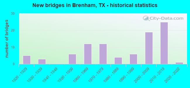
- New bridges - historical statistics
- 51920-1929
- 31930-1939
- 61950-1959
- 121960-1969
- 121970-1979
- 41980-1989
- 61990-1999
- 192000-2009
- 252010-2019
- 12020-2022
FCC Registered Antenna Towers: 303 (See the full list of FCC Registered Antenna Towers)
FCC Registered Commercial Land Mobile Towers: 4 (See the full list of FCC Registered Commercial Land Mobile Towers in Brenham, TX)
FCC Registered Private Land Mobile Towers: 6 (See the full list of FCC Registered Private Land Mobile Towers)
FCC Registered Broadcast Land Mobile Towers: 20 (See the full list of FCC Registered Broadcast Land Mobile Towers)
FCC Registered Microwave Towers: 103 (See the full list of FCC Registered Microwave Towers in this town)
FCC Registered Paging Towers: 6 (See the full list of FCC Registered Paging Towers)
FCC Registered Maritime Coast & Aviation Ground Towers: 4 (See the full list of FCC Registered Maritime Coast & Aviation Ground Towers)
FCC Registered Amateur Radio Licenses: 134 (See the full list of FCC Registered Amateur Radio Licenses in Brenham)
FAA Registered Aircraft Manufacturers and Dealers: 3 (See the full list of FAA Registered Manufacturers and Dealers in Brenham)
FAA Registered Aircraft: 45 (See the full list of FAA Registered Aircraft)
2002 - 2018 National Fire Incident Reporting System (NFIRS) incidents
- Fire incident types reported to NFIRS in Brenham, TX
- 73948.9%Outside Fires
- 45730.2%Structure Fires
- 23815.8%Mobile Property/Vehicle Fires
- 775.1%Other
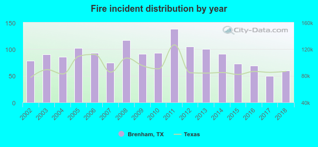 Based on the data from the years 2002 - 2018 the average number of fires per year is 89. The highest number of fire incidents - 138 took place in 2011, and the least - 50 in 2017. The data has a decreasing trend.
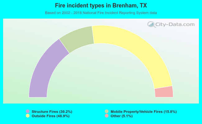 When looking into fire subcategories, the most reports belonged to: Outside Fires (48.9%), and Structure Fires (30.2%).
Fire-safe hotels and motels in Brenham, Texas:
- Americas Best Value Inn, 2217 S Market St, Brenham, Texas 77833 , Phone: (979) 836-1300
- Comfort Suites, 2350 S Day St, Brenham, Texas 77834 , Phone: (979) 421-8100, Fax: (979) 421-8108
- Americas Best Value Inn & Suites, 201 Hwy 290 E, Brenham, Texas 77833 , Phone: (979) 830-1110, Fax: (979) 830-0826
- Hampton Inn & Suites, 2605 Schulte Blvd, Brenham, Texas 77833 , Phone: (979) 337-9898, Fax: (979) 337-9890
- La Quinta Inn & Suites, 2950 Wood Ridge Blvd, Brenham, Texas 77833 , Phone: (979) 836-5551, Fax: (979) 836-8324
- Super 8, 2209 Hwy 290 E, Brenham, Texas 77833 , Phone: (979) 830-8885, Fax: (979) 830-0950
- HOLIDAY INN EXPRESS, 2685 SCHULTZ Blvd, Brenham, Texas 77833 , Phone: (800) 465-4329, Fax: (979) 830-3554
| Most common first names in Brenham, TX among deceased individuals | ||
| Name | Count | Lived (average) |
|---|---|---|
| John | 178 | 76.7 years |
| Willie | 152 | 77.5 years |
| Mary | 139 | 80.6 years |
| Robert | 114 | 74.7 years |
| Henry | 114 | 78.3 years |
| William | 112 | 77.8 years |
| James | 106 | 66.6 years |
| Emma | 103 | 86.0 years |
| Annie | 99 | 84.2 years |
| Minnie | 83 | 85.0 years |
| Most common last names in Brenham, TX among deceased individuals | ||
| Last name | Count | Lived (average) |
|---|---|---|
| Williams | 78 | 77.5 years |
| Johnson | 69 | 77.3 years |
| Smith | 63 | 75.6 years |
| Schroeder | 54 | 77.9 years |
| Winkelmann | 48 | 81.0 years |
| Hahn | 45 | 80.9 years |
| Meyer | 45 | 79.1 years |
| Moore | 42 | 65.3 years |
| Gaskamp | 37 | 78.2 years |
| Loesch | 34 | 81.1 years |
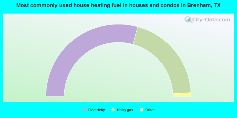
- 58.6%Electricity
- 39.8%Utility gas
- 1.3%Bottled, tank, or LP gas
- 0.3%No fuel used
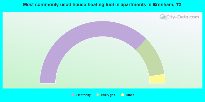
- 74.8%Electricity
- 20.6%Utility gas
- 3.8%No fuel used
- 0.8%Bottled, tank, or LP gas
Brenham compared to Texas state average:
- Unemployed percentage significantly below state average.
- Black race population percentage significantly above state average.
- Median age above state average.
- Foreign-born population percentage significantly below state average.
- Length of stay since moving in significantly above state average.
- Institutionalized population percentage above state average.
- Number of college students above state average.
Brenham on our top lists:
- #15 on the list of "Top 101 cities with the largest percentage of people in schools, hospitals, or wards for the mentally retarded (population 1,000+)"
- #20 on the list of "Top 101 cities with the most residents born in Other Central America (population 500+)"

|
|
Total of 35 patent applications in 2008-2024.