Templeton, Massachusetts
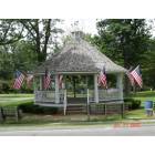
Templeton: Bamdstand on Templeton Common

Templeton: Church on the common after the ice storm Dec 2008

Templeton: Church on the common after the ice storm Dec 2008
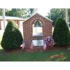
Templeton: Templeton Fire Department Memorial
- add
your
Submit your own pictures of this town and show them to the world
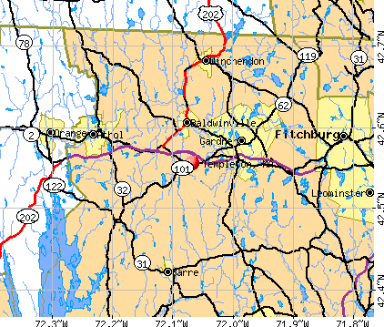
- OSM Map
- General Map
- Google Map
- MSN Map
Population change since 2000: +17.9%
 |
| Males: 4,047 | |
| Females: 3,966 |
| Median resident age: | 41.6 years |
| Massachusetts median age: | 39.2 years |
Zip codes: 01468.
| Templeton: | $87,353 |
| MA: | $94,488 |
Estimated per capita income in 2022: $42,884 (it was $21,994 in 2000)
Templeton town income, earnings, and wages data
Estimated median house or condo value in 2022: $316,200 (it was $114,500 in 2000)
| Templeton: | $316,200 |
| MA: | $534,700 |
Mean prices in 2022: all housing units: $419,164; detached houses: $447,621; townhouses or other attached units: $343,592; in 2-unit structures: $323,295; in 3-to-4-unit structures: $332,295; in 5-or-more-unit structures: $232,758; mobile homes: $113,885
Detailed information about poverty and poor residents in Templeton, MA
Compare current foreclosures near Templeton, MA:
| Photo | Address | Area | Beds / Baths | Price | Details |
|---|---|---|---|---|---|

|
#1
Baldwinville Rd
Templeton, MA 01468
|
1,318 sq. feet
|
1 baths 3 beds |
show details | |

|
#2
Partridgeville Rd
Templeton, MA 01468
|
1,523 sq. feet
|
1 baths 3 beds |
show details | |

|
#3
Orchard Ln
Templeton, MA 01468
|
1,176 sq. feet
|
1 baths 3 beds |
show details | |

|
#4
Columbus Ave
Templeton, MA 01468
|
- sq. feet
|
- baths - beds |
show details | |

|
#5
Prospect St
Templeton, MA 01468
|
- sq. feet
|
- baths - beds |
show details | |

|
#6
Graham St
Leominster, MA 01453
|
1,036 sq. feet
|
1 baths 3 beds |
$485,000
|
show details |

|
#7
Iriquois Dr
Ashburnham, MA 01430
|
2,016 sq. feet
|
2 baths 3 beds |
$369,000
|
show details |

|
#8
Sylvan Ave
Leominster, MA 01453
|
720 sq. feet
|
1 baths 2 beds |
$375,000
|
show details |

|
#9
Whipple Hill Rd
Winchester, NH 03470
|
1,374 sq. feet
|
2 baths 2 beds |
$379,900
|
show details |

|
#10
Parker St
Gardner, MA 01440
|
1,980 sq. feet
|
2 baths 4 beds |
$469,900
|
show details |
| Photo | Address | Area | Beds / Baths | Price | Details |
|---|---|---|---|---|---|

|
#11
Pearl Hill Rd
Fitchburg, MA 01420
|
2,152 sq. feet
|
2 baths 3 beds |
$529,900
|
show details |

|
#12
Clyde St
Fitchburg, MA 01420
|
2,028 sq. feet
|
3 baths 5 beds |
show details | |

|
#13
Rindge State Rd
Ashburnham, MA 01430
|
1,260 sq. feet
|
1 baths 3 beds |
show details | |

|
#14
Grove Ave
Leominster, MA 01453
|
3,097 sq. feet
|
1 baths 4 beds |
show details | |

|
#15
Mallard Drive, Unit 59 Coggshall Crossing Condominium
Fitchburg, MA 01420
|
1,306 sq. feet
|
1 baths 2 beds |
show details | |

|
#16
Garnet St
Fitchburg, MA 01420
|
6,112 sq. feet
|
5 baths 8 beds |
show details | |

|
#17
Lakeshore Dr
Ashburnham, MA 01430
|
- sq. feet
|
- baths - beds |
$5,000
|
show details |

|
#18
Townsend St
Fitchburg, MA 01420
|
864 sq. feet
|
1 baths 2 beds |
show details | |

|
#19
Hall St
Leominster, MA 01453
|
3,724 sq. feet
|
3 baths 5 beds |
show details | |

|
#20
Lionel Ave
Fitchburg, MA 01420
|
1,302 sq. feet
|
1 baths 3 beds |
show details |
| Photo | Address | Area | Beds / Baths | Price | Details |
|---|---|---|---|---|---|

|
#21
Shea St
Fitchburg, MA 01420
|
1,332 sq. feet
|
1 baths 2 beds |
show details | |

|
#22
N Main St, Unit A
Orange, MA 01364
|
598 sq. feet
|
1 baths 2 beds |
show details | |

|
#23
Wauwinet Rd
Barre, MA 01005
|
2,560 sq. feet
|
2 baths 5 beds |
show details | |

|
#24
Springhill Rd
Barre, MA 01005
|
1,075 sq. feet
|
1 baths 2 beds |
show details | |

|
#25
Hartford St
Fitchburg, MA 01420
|
2,484 sq. feet
|
2 baths 6 beds |
show details | |

|
#26
Patton St
Fitchburg, MA 01420
|
1,271 sq. feet
|
1 baths 3 beds |
show details | |

|
#27
Fairmount St
Fitchburg, MA 01420
|
1,456 sq. feet
|
1 baths 3 beds |
show details | |

|
#28
Eddy St
Orange, MA 01364
|
1,116 sq. feet
|
1 baths 2 beds |
show details | |

|
#29
E River St
Orange, MA 01364
|
1,332 sq. feet
|
1 baths 3 beds |
show details | |

|
#30
Lord Brook Rd
Rindge, NH 03461
|
1,920 sq. feet
|
1 baths 3 beds |
show details |
| Photo | Address | Area | Beds / Baths | Price | Details |
|---|---|---|---|---|---|

|
#31
Old Dana Rd
Barre, MA 01005
|
1,255 sq. feet
|
1 baths 3 beds |
show details | |

|
#32
Britney Dr
Rutland, MA 01543
|
1,672 sq. feet
|
1 baths 3 beds |
show details | |

|
#33
Grove Ave
Leominster, MA 01453
|
3,097 sq. feet
|
1 baths 4 beds |
show details | |

|
#34
Walnut Ct
Leominster, MA 01453
|
2,880 sq. feet
|
2 baths 4 beds |
show details | |

|
#35
Pratt St
Fitchburg, MA 01420
|
862 sq. feet
|
1 baths 2 beds |
show details | |

|
#36
Wheeler Ave
Orange, MA 01364
|
1,863 sq. feet
|
2 baths 3 beds |
show details | |

|
#37
Jackson Ave
Rutland, MA 01543
|
2,344 sq. feet
|
2 baths 4 beds |
show details | |

|
#38
Rogers Ave
Orange, MA 01364
|
1,296 sq. feet
|
1 baths 3 beds |
show details | |

|
#39
East Rd
Orange, MA 01364
|
960 sq. feet
|
1 baths 3 beds |
show details | |

|
#40
Gatehouse Rd
Westminster, MA 01473
|
1,118 sq. feet
|
1 baths 2 beds |
show details |
| Photo | Address | Area | Beds / Baths | Price | Details |
|---|---|---|---|---|---|

|
#41
Florence St
Lunenburg, MA 01462
|
1,560 sq. feet
|
1 baths 2 beds |
show details | |

|
#42
Prescott Ln
Orange, MA 01364
|
2,064 sq. feet
|
2 baths 3 beds |
show details | |

|
#43
White Pond Rd
Athol, MA 01331
|
2,340 sq. feet
|
2 baths 5 beds |
show details | |

|
#44
Electric Ave
Lunenburg, MA 01462
|
872 sq. feet
|
1 baths 2 beds |
show details | |

|
#45
Colonial Dr
Rutland, MA 01543
|
1,772 sq. feet
|
2 baths 3 beds |
show details | |

|
#46
W Hill Dr
Westminster, MA 01473
|
1,200 sq. feet
|
2 baths 3 beds |
show details | |

|
#47
Crestview Ln
Westminster, MA 01473
|
1,100 sq. feet
|
1 baths 2 beds |
show details | |

|
#48
New West Townsend Rd
Lunenburg, MA 01462
|
1,270 sq. feet
|
1 baths 4 beds |
show details | |

|
#49
Rebanna Rd
Westminster, MA 01473
|
3,313 sq. feet
|
2 baths 4 beds |
show details | |

|
Check over 1 million property listings on Foreclosure.com!
|
browse all offers | |||

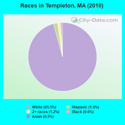
- 7,65695.5%White alone
- 1531.9%Hispanic
- 991.2%Two or more races
- 520.6%Black alone
- 420.5%Asian alone
- 70.09%American Indian alone
- 40.05%Other race alone
Races in Templeton detailed stats: ancestries, foreign born residents, place of birth
According to our research of Massachusetts and other state lists, there were 9 registered sex offenders living in Templeton, Massachusetts as of May 07, 2024.
The ratio of all residents to sex offenders in Templeton is 890 to 1.
Type |
2009 |
2010 |
2011 |
2012 |
2013 |
2014 |
2015 |
2016 |
2017 |
2018 |
2019 |
2020 |
2021 |
2022 |
|---|---|---|---|---|---|---|---|---|---|---|---|---|---|---|
| Murders (per 100,000) | 0 (0.0) | 0 (0.0) | 0 (0.0) | 0 (0.0) | 0 (0.0) | 0 (0.0) | 0 (0.0) | 0 (0.0) | 0 (0.0) | 0 (0.0) | 0 (0.0) | 0 (0.0) | 0 (0.0) | 0 (0.0) |
| Rapes (per 100,000) | 0 (0.0) | 0 (0.0) | 1 (12.4) | 1 (12.3) | 2 (24.7) | 2 (24.4) | 4 (48.8) | 1 (12.2) | 0 (0.0) | 1 (12.3) | 2 (24.7) | 1 (12.3) | 1 (12.2) | 2 (24.3) |
| Robberies (per 100,000) | 2 (25.1) | 2 (25.0) | 2 (24.8) | 1 (12.3) | 2 (24.7) | 0 (0.0) | 2 (24.4) | 0 (0.0) | 0 (0.0) | 1 (12.3) | 0 (0.0) | 1 (12.3) | 0 (0.0) | 0 (0.0) |
| Assaults (per 100,000) | 18 (225.8) | 18 (224.6) | 15 (186.1) | 9 (111.0) | 18 (222.7) | 20 (244.3) | 14 (171.0) | 5 (61.2) | 9 (110.0) | 13 (159.4) | 11 (135.7) | 5 (61.7) | 7 (85.2) | 12 (146.0) |
| Burglaries (per 100,000) | 39 (489.3) | 49 (611.5) | 40 (496.2) | 29 (357.5) | 21 (259.8) | 22 (268.8) | 12 (146.5) | 17 (208.1) | 16 (195.5) | 8 (98.1) | 6 (74.0) | 7 (86.3) | 2 (24.4) | 3 (36.5) |
| Thefts (per 100,000) | 57 (715.2) | 73 (911.0) | 78 (967.5) | 36 (443.8) | 57 (705.2) | 40 (488.7) | 36 (439.6) | 41 (501.9) | 33 (403.2) | 16 (196.2) | 12 (148.0) | 12 (148.0) | 26 (316.6) | 32 (389.3) |
| Auto thefts (per 100,000) | 7 (87.8) | 1 (12.5) | 7 (86.8) | 4 (49.3) | 3 (37.1) | 4 (48.9) | 4 (48.8) | 5 (61.2) | 4 (48.9) | 3 (36.8) | 4 (49.3) | 1 (12.3) | 5 (60.9) | 0 (0.0) |
| Arson (per 100,000) | 0 (0.0) | 2 (25.0) | 1 (12.4) | 0 (0.0) | 0 (0.0) | 4 (48.9) | 3 (36.6) | 0 (0.0) | 0 (0.0) | 0 (0.0) | 0 (0.0) | 1 (12.3) | 0 (0.0) | 0 (0.0) |
| City-Data.com crime index | 122.6 | 132.7 | 135.0 | 82.5 | 121.1 | 110.7 | 112.3 | 61.6 | 55.7 | 63.0 | 61.9 | 38.8 | 46.0 | 66.8 |
The City-Data.com crime index weighs serious crimes and violent crimes more heavily. Higher means more crime, U.S. average is 246.1. It adjusts for the number of visitors and daily workers commuting into cities.
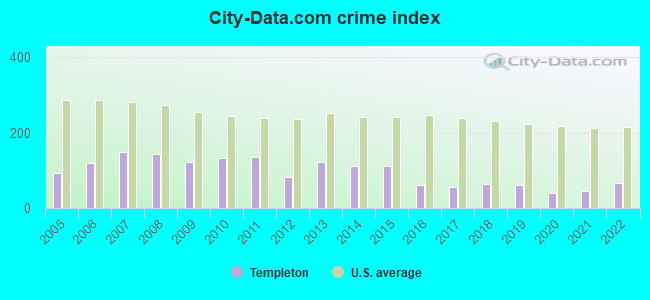
Crime rate in Templeton detailed stats: murders, rapes, robberies, assaults, burglaries, thefts, arson
Full-time law enforcement employees in 2021, including police officers: 14 (9 officers - 9 male; 0 female).
| Officers per 1,000 residents here: | 1.10 |
| Massachusetts average: | 2.53 |
 Recent articles from our blog. Our writers, many of them Ph.D. graduates or candidates, create easy-to-read articles on a wide variety of topics.

 | 2022 Real Estate Observations (1122 replies) |
| Big MA Ancestry Data Thread by Town (31 replies) |
| Hubbardston vs Templeton MA (5 replies) |
| Town in Massachusetts You’d Least Like To Live In? (179 replies) |
| Southerner wanting to move up north. Advice please (155 replies) |
| Ayer? (11 replies) |
Latest news from Templeton, MA collected exclusively by city-data.com from local newspapers, TV, and radio stations
Ancestries: French (19.4%), Irish (16.6%), English (12.8%), French Canadian (11.2%), Italian (9.9%), Polish (8.7%).
Current Local Time: EST time zone
Incorporated in 1762
Elevation: 1141 feet
Land area: 32.0 square miles.
Population density: 250 people per square mile (very low).
102 residents are foreign born
| This town: | 1.5% |
| Massachusetts: | 12.2% |
| Templeton town: | 1.0% ($1,146) |
| Massachusetts: | 1.3% ($2,336) |
Nearest city with pop. 50,000+: Worcester, MA  (25.3 miles , pop. 172,648).
Nearest city with pop. 200,000+: Boston, MA (53.0 miles , pop. 589,141).
Nearest city with pop. 1,000,000+: Bronx, NY (151.9 miles , pop. 1,332,650).
Nearest cities:
), Latitude: 42.58 N, Longitude: 72.07 W
Area code: 978

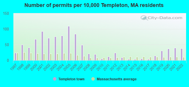
Single-family new house construction building permits:
- 2022: 26 buildings, average cost: $280,900
- 2021: 27 buildings, average cost: $257,700
- 2020: 25 buildings, average cost: $196,200
- 2019: 21 buildings, average cost: $184,000
- 2018: 10 buildings, average cost: $153,000
- 2017: 3 buildings, average cost: $189,500
- 2016: 4 buildings, average cost: $189,500
- 2015: 3 buildings, average cost: $189,500
- 2014: 3 buildings, average cost: $189,500
- 2013: 6 buildings, average cost: $189,500
- 2012: 16 buildings, average cost: $186,600
- 2011: 8 buildings, average cost: $195,000
- 2010: 4 buildings, average cost: $187,500
- 2009: 13 buildings, average cost: $200,400
- 2008: 14 buildings, average cost: $185,100
- 2007: 33 buildings, average cost: $177,800
- 2006: 57 buildings, average cost: $131,500
- 2005: 74 buildings, average cost: $139,400
- 2004: 54 buildings, average cost: $148,500
- 2003: 52 buildings, average cost: $128,400
- 2002: 48 buildings, average cost: $120,600
- 2001: 63 buildings, average cost: $132,000
- 2000: 46 buildings, average cost: $122,700
- 1999: 28 buildings, average cost: $113,900
- 1998: 34 buildings, average cost: $87,400
- 1997: 16 buildings, average cost: $106,400
| Here: | 3.7% |
| Massachusetts: | 3.5% |
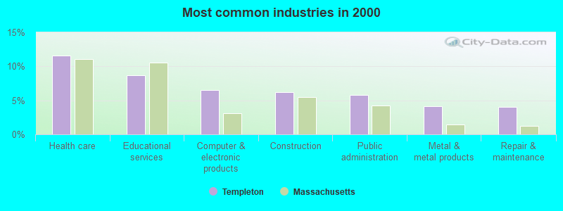
- Health care (11.6%)
- Educational services (8.7%)
- Computer & electronic products (6.5%)
- Construction (6.2%)
- Public administration (5.8%)
- Metal & metal products (4.2%)
- Repair & maintenance (4.1%)
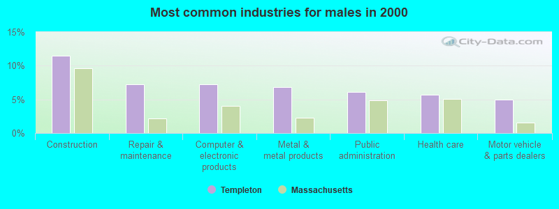
- Construction (11.5%)
- Repair & maintenance (7.3%)
- Computer & electronic products (7.3%)
- Metal & metal products (6.9%)
- Public administration (6.1%)
- Health care (5.7%)
- Motor vehicle & parts dealers (4.9%)
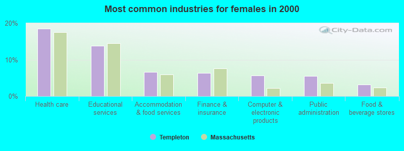
- Health care (18.4%)
- Educational services (13.8%)
- Accommodation & food services (6.6%)
- Finance & insurance (6.4%)
- Computer & electronic products (5.7%)
- Public administration (5.6%)
- Food & beverage stores (3.1%)
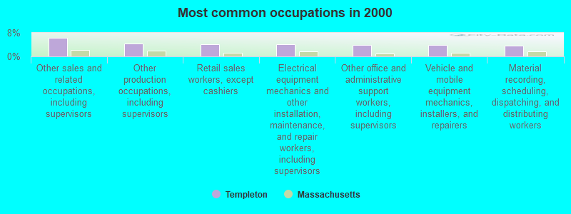
- Other sales and related occupations, including supervisors (6.4%)
- Other production occupations, including supervisors (4.4%)
- Retail sales workers, except cashiers (4.2%)
- Electrical equipment mechanics and other installation, maintenance, and repair workers, including supervisors (4.1%)
- Other office and administrative support workers, including supervisors (4.0%)
- Vehicle and mobile equipment mechanics, installers, and repairers (3.9%)
- Material recording, scheduling, dispatching, and distributing workers (3.7%)
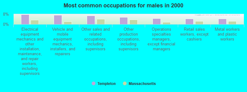
- Electrical equipment mechanics and other installation, maintenance, and repair workers, including supervisors (7.7%)
- Vehicle and mobile equipment mechanics, installers, and repairers (7.3%)
- Other sales and related occupations, including supervisors (6.8%)
- Other production occupations, including supervisors (5.5%)
- Operations specialties managers, except financial managers (4.5%)
- Retail sales workers, except cashiers (4.4%)
- Metal workers and plastic workers (4.3%)
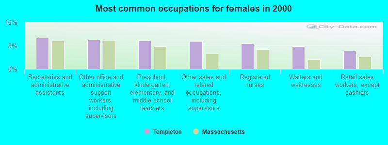
- Secretaries and administrative assistants (6.7%)
- Other office and administrative support workers, including supervisors (6.3%)
- Preschool, kindergarten, elementary, and middle school teachers (6.1%)
- Other sales and related occupations, including supervisors (6.0%)
- Registered nurses (5.5%)
- Waiters and waitresses (4.9%)
- Retail sales workers, except cashiers (3.9%)
Average climate in Templeton, Massachusetts
Based on data reported by over 4,000 weather stations


(lower is better)
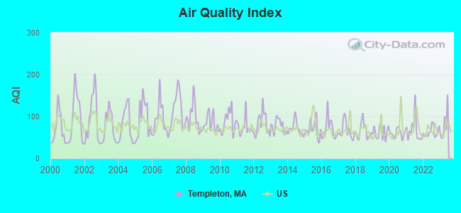
Air Quality Index (AQI) level in 2022 was 63.4. This is about average.
| City: | 63.4 |
| U.S.: | 72.6 |
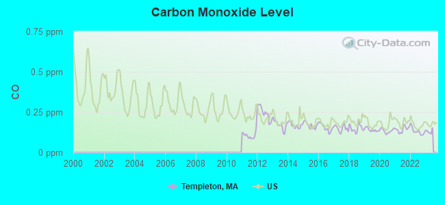
Carbon Monoxide (CO) [ppm] level in 2022 was 0.131. This is significantly better than average. Closest monitor was 21.7 miles away from the city center.
| City: | 0.131 |
| U.S.: | 0.251 |
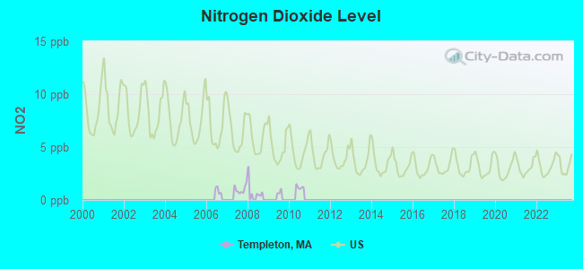
Nitrogen Dioxide (NO2) [ppb] level in 2007 was 1.02. This is significantly better than average. Closest monitor was 8.3 miles away from the city center.
| City: | 1.02 |
| U.S.: | 5.11 |
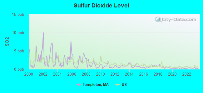
Sulfur Dioxide (SO2) [ppb] level in 2022 was 0.302. This is significantly better than average. Closest monitor was 4.3 miles away from the city center.
| City: | 0.302 |
| U.S.: | 1.515 |
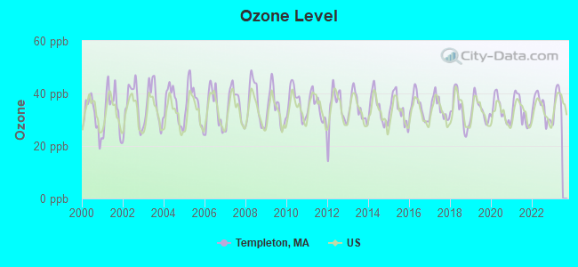
Ozone [ppb] level in 2022 was 34.6. This is about average. Closest monitor was 14.4 miles away from the city center.
| City: | 34.6 |
| U.S.: | 33.3 |
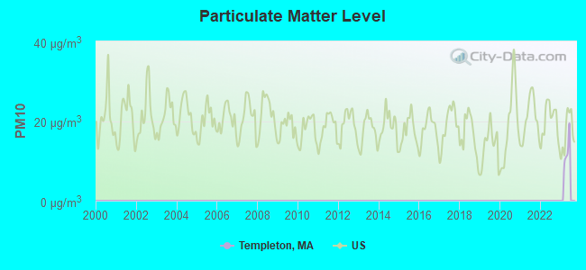
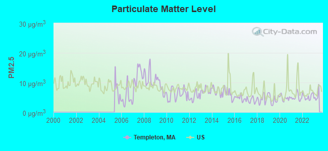
Particulate Matter (PM2.5) [µg/m3] level in 2022 was 5.31. This is significantly better than average. Closest monitor was 14.2 miles away from the city center.
| City: | 5.31 |
| U.S.: | 8.11 |
Tornado activity:
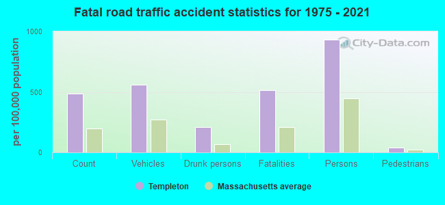
Templeton-area historical tornado activity is slightly above Massachusetts state average. It is 15% smaller than the overall U.S. average.
On 6/9/1953, a category F4 (max. wind speeds 207-260 mph) tornado 9.3 miles away from the Templeton town center killed 90 people and injured 1228 people and caused between $50,000,000 and $500,000,000 in damages.
On 6/22/1981, a category F3 (max. wind speeds 158-206 mph) tornado 5.8 miles away from the town center injured 3 people and caused between $5000 and $50,000 in damages.
Earthquake activity:
Templeton-area historical earthquake activity is significantly above Massachusetts state average. It is 71% smaller than the overall U.S. average.On 10/7/1983 at 10:18:46, a magnitude 5.3 (5.1 MB, 5.3 LG, 5.1 ML, Class: Moderate, Intensity: VI - VII) earthquake occurred 148.9 miles away from Templeton center
On 4/20/2002 at 10:50:47, a magnitude 5.3 (5.3 ML, Depth: 3.0 mi) earthquake occurred 156.7 miles away from Templeton center
On 4/20/2002 at 10:50:47, a magnitude 5.2 (5.2 MB, 4.2 MS, 5.2 MW, 5.0 MW) earthquake occurred 155.8 miles away from Templeton center
On 1/19/1982 at 00:14:42, a magnitude 4.7 (4.5 MB, 4.7 MD, 4.5 LG, Class: Light, Intensity: IV - V) earthquake occurred 67.9 miles away from Templeton center
On 10/16/2012 at 23:12:25, a magnitude 4.7 (4.7 ML, Depth: 10.0 mi) earthquake occurred 100.1 miles away from Templeton center
On 10/2/1994 at 11:27:22, a magnitude 3.7 (3.5 LG, 3.7 LG, Depth: 6.2 mi, Class: Light, Intensity: II - III) earthquake occurred 19.4 miles away from the city center
Magnitude types: regional Lg-wave magnitude (LG), body-wave magnitude (MB), duration magnitude (MD), local magnitude (ML), surface-wave magnitude (MS), moment magnitude (MW)
Natural disasters:
The number of natural disasters in Worcester County (27) is a lot greater than the US average (15).Major Disasters (Presidential) Declared: 15
Emergencies Declared: 12
Causes of natural disasters: Floods: 9, Storms: 8, Hurricanes: 6, Snowstorms: 5, Winter Storms: 4, Blizzards: 2, Snows: 2, Fire: 1, Heavy Rain: 1, Snowfall: 1, Tornado: 1, Wind: 1 (Note: some incidents may be assigned to more than one category).

Hospitals and medical centers near Templeton:
- BALDWINVILLE NURSING HOME (Nursing Home, about 3 miles away; BALDWINVILLE, MA)
- TEMPLETON DEVELOPMENTAL CENTER (Hospital, about 3 miles away; BALDWINVILLE, MA)
- HEYWOOD HOSPITAL Acute Care Hospitals (about 5 miles away; GARDNER, MA)
- GARDNER MANOR (Nursing Home, about 5 miles away; GARDNER, MA)
- GARDNER SKILLED NURSING CENTER (Nursing Home, about 5 miles away; GARDNER, MA)
- LEGEND REHABILITATION AND NURSING CENTER (Nursing Home, about 5 miles away; GARDNER, MA)
- WACHUSETT MANOR (Nursing Home, about 5 miles away; GARDNER, MA)
Colleges/universities with over 2000 students nearest to Templeton:
- Mount Wachusett Community College (about 5 miles; Gardner, MA; Full-time enrollment: 3,143)
- Franklin Pierce University (about 15 miles; Rindge, NH; FT enrollment: 2,139)
- Fitchburg State University (about 15 miles; Fitchburg, MA; FT enrollment: 5,010)
- Quinsigamond Community College (about 24 miles; Worcester, MA; FT enrollment: 5,877)
- Assumption College (about 24 miles; Worcester, MA; FT enrollment: 2,580)
- Worcester State University (about 25 miles; Worcester, MA; FT enrollment: 5,426)
- Worcester Polytechnic Institute (about 25 miles; Worcester, MA; FT enrollment: 3,930)
Public elementary/middle school in Templeton:
- TEMPLETON CENTER (Students: 162, Location: 17 SOUTH ROAD, Grades: KG-1)
Points of interest:
Notable locations in Templeton: Gardner Sewage Disposal Plant (A), Otter River Sportsmens Club (B), Templeton Fish and Gun Club (C), Templeton Land Fill (D), Templeton Sewer Plant (E), Baldwinville Nursing Home (F), Templeton Fire Department East Templeton (G), Templeton Fire Department (H), Templeton Fire Department Station 2 Headquarters (I), Ridgerty Club (J). Display/hide their locations on the map
Churches in Templeton include: Church in the Wildewood (A), Saint Vincent De Paul Church (B), Saint Martins Church (C). Display/hide their locations on the map
Cemeteries: Baptist Common Cemetery (1), Greenlawn Cemetery (2), Norcross Hill Cemetery (3), Pine Grove Cemetery (4). Display/hide their locations on the map
Lakes and reservoirs: Snake Pond (A), Hansel Pond (B), Day Millpond (C), Cook Pond (D), Stone Bridge Pond (E), Greenwood Pond (F), East Templeton Pond (G), Partridgeville Pond (H). Display/hide their locations on the map
Streams, rivers, and creeks: Bailey Brook (A), Crow Hill Brook (B), Templeton Brook (C), Trout Brook (D), Norcross Hill Brook (E). Display/hide their locations on the map
Parks in Templeton include: The Common (1), Templeton Common Historic District (2), Baldwinville Village Historic District (3), Gilman-Waite Field (4). Display/hide their locations on the map
Birthplace of: Charles Knowlton - Physician, George A. Fuller - Architect, George P. Hawkes - Brigadier general in the Army during the Civil War.
Drinking water stations with addresses in Templeton and their reported violations in the past:
TRAIL RIDGE CONDOMINIUMS (Address: 32 SANDY PINE ROAD , Population served: 42, Groundwater):Past health violations:Past monitoring violations:
- MCL, Monthly (TCR) - In JUN-2014, Contaminant: Coliform. Follow-up actions: St AO (w/o penalty) issued (SEP-05-2014)
- MCL, Monthly (TCR) - In DEC-2011, Contaminant: Coliform. Follow-up actions: St AO (w/o penalty) issued (FEB-08-2012)
- MCL, Monthly (TCR) - In JUL-2010, Contaminant: Coliform. Follow-up actions: St AO (w/o penalty) issued (OCT-21-2010)
- MCL, Monthly (TCR) - In JUN-2010, Contaminant: Coliform. Follow-up actions: St AO (w/o penalty) issued (OCT-21-2010)
- MCL, Monthly (TCR) - In APR-2010, Contaminant: Coliform. Follow-up actions: St AO (w/o penalty) issued (JUL-14-2010)
- MCL, Monthly (TCR) - In MAR-2010, Contaminant: Coliform. Follow-up actions: St AO (w/o penalty) issued (JUL-14-2010)
- 4 other older health violations
- Follow-up Or Routine LCR Tap M/R - In APR-01-2011, Contaminant: Lead and Copper Rule. Follow-up actions: St AO (w/o penalty) issued (SEP-09-2011), St Compliance achieved (JAN-27-2012)
- Follow-up Or Routine LCR Tap M/R - In OCT-01-2010, Contaminant: Lead and Copper Rule. Follow-up actions: St AO (w/o penalty) issued (SEP-09-2011), St Compliance achieved (JAN-27-2012)
- Follow-up Or Routine LCR Tap M/R - In OCT-01-2009, Contaminant: Lead and Copper Rule. Follow-up actions: St AO (w/o penalty) issued (FEB-22-2010), St Compliance achieved (JUN-15-2010)
- 4 routine major monitoring violations
- 7 minor monitoring violations
- 52 regular monitoring violations
| This town: | 2.7 people |
| Massachusetts: | 2.5 people |
| This town: | 73.7% |
| Whole state: | 63.0% |
| This town: | 8.2% |
| Whole state: | 7.0% |
Likely homosexual households (counted as self-reported same-sex unmarried-partner households)
- Lesbian couples: 0.3% of all households
- Gay men: 0.2% of all households
| This town: | 9.1% |
| Whole state: | 9.3% |
| This town: | 2.6% |
| Whole state: | 4.4% |
People in group quarters in Templeton in 2010:
- 118 people in residential treatment centers for adults
- 92 people in nursing facilities/skilled-nursing facilities
- 26 people in residential treatment centers for juveniles (non-correctional)
- 2 people in other noninstitutional facilities
People in group quarters in Templeton in 2000:
- 158 people in schools, hospitals, or wards for the intellectually disabled
- 76 people in nursing homes
- 20 people in training schools for juvenile delinquents
- 9 people in homes for the mentally retarded
- 6 people in homes for the mentally ill
For population 15 years and over in Templeton:

- Never married: 21.5%
- Now married: 59.7%
- Separated: 1.3%
- Widowed: 6.8%
- Divorced: 10.7%
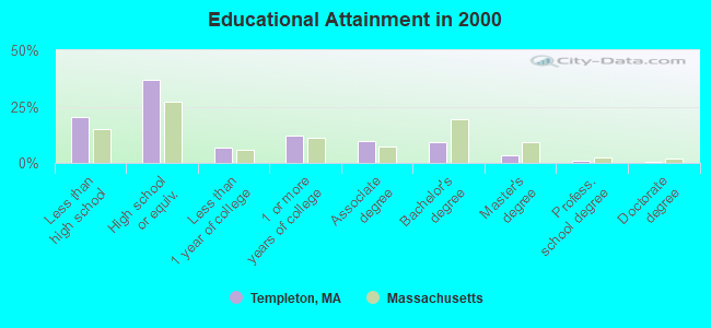
For population 25 years and over in Templeton:
- High school or higher: 79.4%
- Bachelor's degree or higher: 13.6%
- Graduate or professional degree: 4.5%
- Unemployed: 4.9%
- Mean travel time to work (commute): 25.2 minutes
| Here: | 12.4 |
| Massachusetts average: | 13.1 |


Graphs represent county-level data. Detailed 2008 Election Results
Religion statistics for Templeton, MA (based on Worcester County data)


| Religion | Adherents | Congregations |
|---|---|---|
| Catholic | 306,925 | 118 |
| Mainline Protestant | 43,326 | 171 |
| Evangelical Protestant | 37,511 | 203 |
| Other | 18,931 | 69 |
| Orthodox | 7,935 | 15 |
| Black Protestant | 497 | 6 |
| None | 383,427 | - |
Food Environment Statistics:
| This county: | 1.73 / 10,000 pop. |
| Massachusetts: | 1.98 / 10,000 pop. |
| Worcester County: | 0.05 / 10,000 pop. |
| State: | 0.05 / 10,000 pop. |
| Worcester County: | 1.79 / 10,000 pop. |
| Massachusetts: | 2.22 / 10,000 pop. |
| Here: | 2.22 / 10,000 pop. |
| Massachusetts: | 1.77 / 10,000 pop. |
| Worcester County: | 7.27 / 10,000 pop. |
| State: | 8.76 / 10,000 pop. |
| This county: | 8.0% |
| Massachusetts: | 8.1% |
| This county: | 24.0% |
| Massachusetts: | 22.5% |
| Worcester County: | 16.6% |
| Massachusetts: | 16.5% |
4.71% of this county's 2021 resident taxpayers lived in other counties in 2020 ($76,229 average adjusted gross income)
| Here: | 4.71% |
| Massachusetts average: | 6.35% |
0.02% of residents moved from foreign countries ($100 average AGI)
Worcester County: 0.02% Massachusetts average: 0.01%
Top counties from which taxpayers relocated into this county between 2020 and 2021:
| from Middlesex County, MA | |
| from Norfolk County, MA | |
| from Suffolk County, MA |
4.84% of this county's 2020 resident taxpayers moved to other counties in 2021 ($87,252 average adjusted gross income)
| Here: | 4.84% |
| Massachusetts average: | 7.18% |
0.03% of residents moved to foreign countries ($199 average AGI)
Worcester County: 0.03% Massachusetts average: 0.02%
Top counties to which taxpayers relocated from this county between 2020 and 2021:
| to Middlesex County, MA | |
| to Norfolk County, MA | |
| to Suffolk County, MA |
Strongest AM radio stations in Templeton:
- WCRN (830 AM; 50 kW; WORCESTER, MA; Owner: CARTER BROADCASTING CORPORATION)
- WVNE (760 AM; daytime; 25 kW; LEICESTER, MA; Owner: BLOUNT MASSCOM, INC.)
- WGAW (1340 AM; 1 kW; GARDNER, MA; Owner: ANASTOS MEDIA GROUP, INC.)
- WNNZ (640 AM; 50 kW; WESTFIELD, MA; Owner: CLEAR CHANNEL BROADCASTING LICENSES, INC.)
- WRKO (680 AM; 50 kW; BOSTON, MA; Owner: ENTERCOM BOSTON LICENSE, LLC)
- WEIM (1280 AM; 5 kW; FITCHBURG, MA; Owner: LIVEAIR COMMUNICATIONS, INC.)
- WKOX (1200 AM; 50 kW; FRAMINGHAM, MA; Owner: CAPSTAR TX LIMITED PARTNERSHIP)
- WCAT (700 AM; daytime; 2 kW; ORANGE-ATHOL, MA; Owner: CITADEL BROADCASTING COMPANY)
- WEEI (850 AM; 50 kW; BOSTON, MA; Owner: ENTERCOM BOSTON LICENSE, LLC)
- WBIX (1060 AM; 40 kW; NATICK, MA; Owner: LANGER BROADCASTING CORPORATION)
- WALE (990 AM; 50 kW; GREENVILLE, RI; Owner: NORTH AMERICAN BROADCASTING CO., INC.)
- WTAG (580 AM; 5 kW; WORCESTER, MA; Owner: CAPSTAR TX LIMITED PARTNERSHIP)
- WFGL (960 AM; 2 kW; FITCHBURG, MA; Owner: CSN INTERNATIONAL)
Strongest FM radio stations in Templeton:
- WAHL (99.9 FM; ATHOL, MA; Owner: CITADEL BROADCASTING COMPANY)
- WINQ (97.7 FM; WINCHENDON, MA; Owner: SAGA COMMUNICATIONS OF NEW ENGLAND, LLC)
- WFEX (92.1 FM; PETERBOROUGH, NH; Owner: FNX BROADCASTING OF NEW HAMPSHIRE LLC)
- WXLO (104.5 FM; FITCHBURG, MA; Owner: CITADEL BROADCASTING COMPANY)
- WAAF (107.3 FM; WORCESTER, MA; Owner: ENTERCOM BOSTON LICENSE, LLC)
- WSRS (96.1 FM; WORCESTER, MA; Owner: CAPSTAR TX LIMITED PARTNERSHIP)
- WFCR (88.5 FM; AMHERST, MA; Owner: UNIVERSITY OF MASSACHUSETTS)
- WAMH (89.3 FM; AMHERST, MA; Owner: TRUSTEES OF AMHERST COLLEGE)
- WHDQ (106.1 FM; CLAREMONT, NH; Owner: GREAT NORTHERN RADIO, L.L.C.)
- WYRY (104.9 FM; HINSDALE, NH; Owner: TRI-VALLEY BROADCASTING CORPORATION)
- WEQX (102.7 FM; MANCHESTER, VT; Owner: NORTHSHIRE COMMUNICATIONS, INC.)
- WAMC-FM (90.3 FM; ALBANY, NY; Owner: WAMC)
- WPVQ (95.3 FM; GREENFIELD, MA; Owner: GREAT NORTHERN RADIO, L.L.C.)
- WJAN (95.1 FM; SUNDERLAND, VT; Owner: 6 JOHNSON ROAD LICENSES, INC.)
- WOQL (98.7 FM; WINCHESTER, NH; Owner: SAGA COMMUNICATIONS OF NEW HAMPSHIRE, LLC)
- WVPR (89.5 FM; WINDSOR, VT; Owner: VERMONT PUBLIC RADIO)
- WKNE (103.7 FM; KEENE, NH; Owner: SAGA COMMUNICATIONS OF NEW ENGLAND, LLC)
- WJDF (97.3 FM; ORANGE, MA; Owner: DEANE BROTHERS BROADCASTING CORP.)
- WGIR-FM (101.1 FM; MANCHESTER, NH; Owner: CAPSTAR TX LIMITED PARTNERSHIP)
- WEVN (90.7 FM; KEENE, NH; Owner: NEW HAMPSHIRE PUBLIC RADIO, INC.)
TV broadcast stations around Templeton:
- WUNI (Channel 27; WORCESTER, MA; Owner: ENTRAVISION HOLDINGS, LLC)
- WYDN (Channel 48; WORCESTER, MA; Owner: EDUCATIONAL PUBLIC TV CORPORATION)
- WUTF (Channel 66; MARLBOROUGH, MA; Owner: TELEFUTURA BOSTON LLC)
- WCVB-TV (Channel 5; BOSTON, MA; Owner: WCVB HEARST-ARGYLE TV, INC.)
- WGBH-TV (Channel 2; BOSTON, MA; Owner: WGBH EDUCATIONAL FOUNDATION)
- WMFP (Channel 62; LAWRENCE, MA; Owner: WSAH LICENSE, INC.)
- WBZ-TV (Channel 4; BOSTON, MA; Owner: VIACOM INC.)
- WGBX-TV (Channel 44; BOSTON, MA; Owner: WGBH EDUCATIONAL FOUNDATION)
- WSBK-TV (Channel 38; BOSTON, MA; Owner: VIACOM INC.)
- WLVI-TV (Channel 56; CAMBRIDGE, MA; Owner: WLVI, INC.)
- WFXT (Channel 25; BOSTON, MA; Owner: FOX TELEVISION STATIONS INC.)
- National Bridge Inventory (NBI) Statistics
- 26Number of bridges
- 174ft / 53.2mTotal length
- $29,352,000Total costs
- 125,369Total average daily traffic
- 6,479Total average daily truck traffic
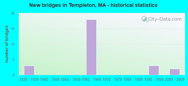
- New bridges - historical statistics
- 31930-1939
- 181960-1969
- 31990-1999
- 22000-2009
FCC Registered Cell Phone Towers:
1 (See the full list of FCC Registered Cell Phone Towers in Templeton)FCC Registered Antenna Towers:
22 (See the full list of FCC Registered Antenna Towers)FCC Registered Broadcast Land Mobile Towers:
2- Otter Rvr State Forest Hdqtrs (Lat: 42.622583 Lon: -72.076750), Call Sign: WBE211,
Assigned Frequencies: 151.415 MHz, Grant Date: 10/19/1995, Expiration Date: 10/19/2000, Cancellation Date: 12/24/2000, Registrant: Massachusetts, Commonwealth Of, Mt Wachusett State Reservation, Princeton, MA 01541-0248, Phone: (617) 727-3189
- 33 South Road (Lat: 42.553056 Lon: -72.066972), Type: Upole, Structure height: 9.1 m, Overall height: 16 m, Call Sign: WQLV547,
Assigned Frequencies: 465.375 MHz, Grant Date: 04/07/2020, Expiration Date: 05/03/2030, Certifier: David Whitaker, Registrant: Skylines Unlimited Inc, 100 Stone Church Road, Carlisle, PA 17015, Phone: (717) 218-5003, Fax: (717) 218-5005, Email:
FCC Registered Microwave Towers:
2- TEMPLETON, 22 Johnson Ave (Lat: 42.558139 Lon: -72.051194), Type: Mast, Structure height: 42.1 m, Overall height: 44.5 m, Call Sign: WPNN255,
Assigned Frequencies: 10562.5 MHz, Grant Date: 02/12/2008, Expiration Date: 04/01/2018, Cancellation Date: 07/20/2016, Certifier: Carol L Tacker, Registrant: At&t Mobility LLC, 1120 20th Street, Nw - Suite 1000, Washington, DC 20036, Phone: (202) 457-2055, Fax: (202) 457-3073, Email:
- Templeton, Off Johnson Avenue (Lat: 42.558111 Lon: -72.051278), Type: Tower, Structure height: 43.6 m, Overall height: 48.7 m, Call Sign: WQEJ614,
Assigned Frequencies: 6615.00 MHz, Grant Date: 02/13/2006, Expiration Date: 02/13/2016, Cancellation Date: 02/20/2014, Certifier: Richard A Craig, Registrant: Verizon Wireless, 1120 Sanctuary Pkwy, #150 Gasa5reg, Alpharetta, GA 30009-7630, Phone: (770) 797-1070, Fax: (770) 797-1036, Email:
FCC Registered Amateur Radio Licenses:
27 (See the full list of FCC Registered Amateur Radio Licenses in Templeton)FAA Registered Aircraft:
9 (See the full list of FAA Registered Aircraft in Templeton)2002 - 2018 National Fire Incident Reporting System (NFIRS) incidents
- Fire incident types reported to NFIRS in Templeton, MA
- 11055.3%Structure Fires
- 5427.1%Outside Fires
- 2814.1%Mobile Property/Vehicle Fires
- 73.5%Other
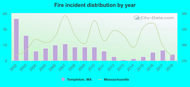 Based on the data from the years 2002 - 2018 the average number of fires per year is 12. The highest number of reported fire incidents - 40 took place in 2002, and the least - 1 in 2013. The data has a declining trend.
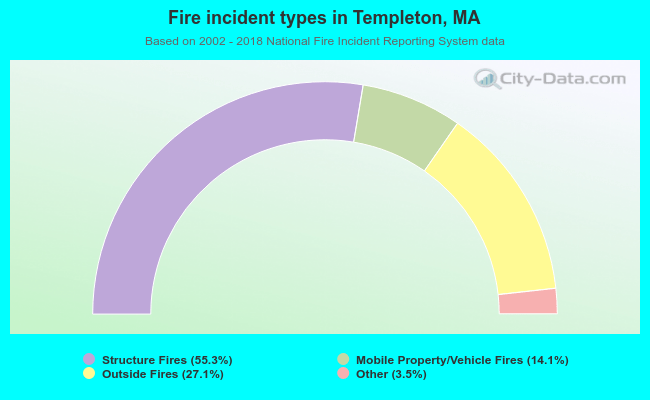 When looking into fire subcategories, the most incidents belonged to: Structure Fires (55.3%), and Outside Fires (27.1%).
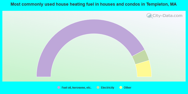
- 84.3%Fuel oil, kerosene, etc.
- 6.4%Electricity
- 3.9%Bottled, tank, or LP gas
- 3.5%Wood
- 1.4%Utility gas
- 0.3%Coal or coke
- 0.3%Other fuel
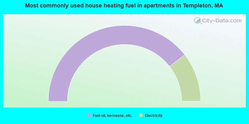
- 79.0%Fuel oil, kerosene, etc.
- 21.0%Electricity
Templeton compared to Massachusetts state average:
- Median house value below state average.
- Unemployed percentage significantly below state average.
- Black race population percentage significantly below state average.
- Hispanic race population percentage significantly below state average.
- Foreign-born population percentage significantly below state average.
- Renting percentage below state average.
- Length of stay since moving in significantly above state average.
- Number of rooms per house significantly below state average.
- House age significantly below state average.
- Percentage of population with a bachelor's degree or higher significantly below state average.
Templeton on our top lists:
- #6 on the list of "Top 101 cities with largest percentage of males in occupations: operations specialties managers except financial managers (population 5,000+)"
- #6 on the list of "Top 101 cities with largest percentage of males in industries: health and personal care, except drug, stores (population 5,000+)"
- #7 on the list of "Top 101 cities with largest percentage of males in occupations: customer service representatives (population 5,000+)"
- #9 on the list of "Top 101 cities with largest percentage of males in industries: repair and maintenance (population 5,000+)"
- #19 on the list of "Top 101 cities with largest percentage of males in industries: furniture and related product manufacturing (population 5,000+)"
- #21 on the list of "Top 101 cities with largest percentage of females in industries: other transportation, and support activities, and couriers (population 5,000+)"
- #24 on the list of "Top 101 cities with largest percentage of males in industries: motor vehicle and parts dealers (population 5,000+)"
- #25 on the list of "Top 101 cities with largest percentage of females in industries: hardware, plumbing and heating equipment, and supplies merchant wholesalers (population 5,000+)"
- #27 on the list of "Top 101 cities with largest percentage of males in occupations: other healthcare support occupations (population 5,000+)"
- #29 on the list of "Top 101 cities with largest percentage of males in industries: leather and allied products (population 5,000+)"
- #31 on the list of "Top 101 cities with the largest percentage of people in schools, hospitals, or wards for the mentally retarded (population 1,000+)"
- #34 on the list of "Top 101 cities with largest percentage of males in occupations: vehicle and mobile equipment mechanics, installers, and repairers (population 5,000+)"
- #38 on the list of "Top 101 cities with largest percentage of females in industries: computer and electronic products (population 5,000+)"
- #39 on the list of "Top 101 cities with largest percentage of females in industries: furniture and related product manufacturing (population 5,000+)"
- #41 on the list of "Top 101 cities with largest percentage of females in occupations: motor vehicle operators except bus and truck drivers (population 5,000+)"
- #45 on the list of "Top 101 cities with largest percentage of females in industries: lumber and other construction materials merchant wholesalers (population 5,000+)"
- #49 on the list of "Top 101 cities with largest percentage of females in occupations: waiters and waitresses (population 5,000+)"
- #56 on the list of "Top 101 cities with largest percentage of males in industries: building material and garden equipment and supplies dealers (population 5,000+)"
- #73 on the list of "Top 101 cities with largest percentage of males in industries: computer and electronic products (population 5,000+)"
- #76 on the list of "Top 101 cities with the largest city-data.com crime index decrease from 2011 to 2012 (population 5,000+)"
- #4 on the list of "Top 101 counties with the highest carbon monoxide air pollution readings in 2012 (ppm)"
- #5 on the list of "Top 101 counties with the most Catholic congregations"
- #12 on the list of "Top 101 counties with the highest surface withdrawal of fresh water for public supply"
- #16 on the list of "Top 101 counties with the highest total withdrawal of fresh water for public supply"
- #23 on the list of "Top 101 counties with the highest Sulfur Oxides Annual air pollution readings in 2012 (µg/m3)"

|
|
Total of 19 patent applications in 2008-2024.