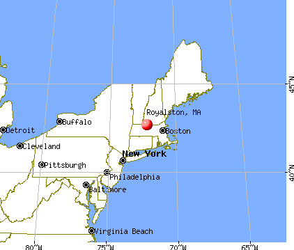
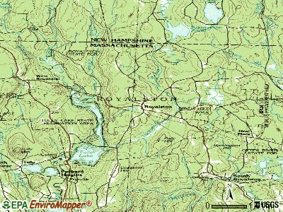
Royalston, Massachusetts

Royalston: Larence river. Royalston
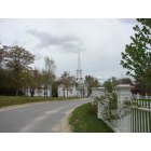
Royalston: Beautiful Historic Royalston Common, a few homes for sale here!
- add
your
Submit your own pictures of this town and show them to the world
- OSM Map
- General Map
- Google Map
- MSN Map
Population change since 2000: +0.3%
 |
| Males: 626 | |
| Females: 632 |
| Median resident age: | 45.6 years |
| Massachusetts median age: | 39.2 years |
Zip codes: 01368.
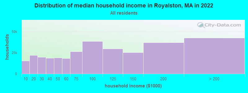
| Royalston: | $80,078 |
| MA: | $94,488 |
Estimated per capita income in 2022: $35,675 (it was $18,297 in 2000)
Royalston town income, earnings, and wages data
Estimated median house or condo value in 2022: $313,438 (it was $113,500 in 2000)
| Royalston: | $313,438 |
| MA: | $534,700 |
Mean prices in 2022: all housing units: $419,164; detached houses: $447,621; townhouses or other attached units: $343,592; in 2-unit structures: $323,295; in 3-to-4-unit structures: $332,295; in 5-or-more-unit structures: $232,758; mobile homes: $113,885
Detailed information about poverty and poor residents in Royalston, MA


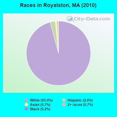
- 1,20395.6%White alone
- 332.6%Hispanic
- 90.7%Asian alone
- 90.7%Two or more races
- 30.2%Black alone
- 10.08%American Indian alone
Races in Royalston detailed stats: ancestries, foreign born residents, place of birth
According to our research of Massachusetts and other state lists, there was 1 registered sex offender living in Royalston, Massachusetts as of May 19, 2024.
The ratio of all residents to sex offenders in Royalston is 1,258 to 1.
The ratio of registered sex offenders to all residents in this city is near the state average.
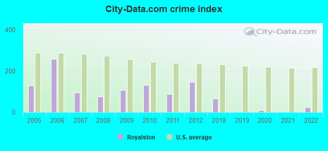
Type |
2009 |
2010 |
2011 |
2012 |
2018 |
2019 |
2020 |
2021 |
2022 |
|---|---|---|---|---|---|---|---|---|---|
| Murders (per 100,000) | 0 (0.0) | 0 (0.0) | 0 (0.0) | 0 (0.0) | 0 (0.0) | 0 (0.0) | 0 (0.0) | 0 (0.0) | 0 (0.0) |
| Rapes (per 100,000) | 0 (0.0) | 1 (79.5) | 0 (0.0) | 1 (78.6) | 0 (0.0) | 0 (0.0) | 0 (0.0) | 0 (0.0) | 0 (0.0) |
| Robberies (per 100,000) | 0 (0.0) | 0 (0.0) | 0 (0.0) | 0 (0.0) | 0 (0.0) | 0 (0.0) | 0 (0.0) | 0 (0.0) | 1 (79.0) |
| Assaults (per 100,000) | 4 (284.5) | 1 (79.5) | 2 (158.0) | 0 (0.0) | 4 (314.0) | 0 (0.0) | 0 (0.0) | 0 (0.0) | 0 (0.0) |
| Burglaries (per 100,000) | 8 (569.0) | 7 (556.4) | 6 (473.9) | 13 (1,021) | 0 (0.0) | 0 (0.0) | 0 (0.0) | 0 (0.0) | 0 (0.0) |
| Thefts (per 100,000) | 4 (284.5) | 4 (318.0) | 7 (552.9) | 2 (157.1) | 1 (78.5) | 0 (0.0) | 3 (235.8) | 0 (0.0) | 0 (0.0) |
| Auto thefts (per 100,000) | 0 (0.0) | 0 (0.0) | 0 (0.0) | 1 (78.6) | 0 (0.0) | 0 (0.0) | 0 (0.0) | 0 (0.0) | 0 (0.0) |
| Arson (per 100,000) | 0 (0.0) | 0 (0.0) | 0 (0.0) | 0 (0.0) | 0 (0.0) | 0 (0.0) | 0 (0.0) | 0 (0.0) | 0 (0.0) |
| City-Data.com crime index | 108.1 | 131.2 | 86.9 | 146.9 | 65.9 | 0.0 | 9.4 | 0.0 | 23.7 |
The City-Data.com crime index weighs serious crimes and violent crimes more heavily. Higher means more crime, U.S. average is 246.1. It adjusts for the number of visitors and daily workers commuting into cities.
Crime rate in Royalston detailed stats: murders, rapes, robberies, assaults, burglaries, thefts, arson
Full-time law enforcement employees in 2016, including police officers: 1 (1 officers - 1 male; 0 female).
| Officers per 1,000 residents here: | 0.79 |
| Massachusetts average: | 2.63 |
 Recent articles from our blog. Our writers, many of them Ph.D. graduates or candidates, create easy-to-read articles on a wide variety of topics.

 | Big MA Ancestry Data Thread by Town (31 replies) |
| How Much Massachusetts Households Make Per Year: Census Data (37 replies) |
| Pros and Cons of small town living (18 replies) |
| Boundaries of MA's regions (63 replies) |
| Hiking in the area? (35 replies) |
| Places to avoid in Fitchburg (49 replies) |
Latest news from Royalston, MA collected exclusively by city-data.com from local newspapers, TV, and radio stations
Ancestries: French (17.6%), English (16.7%), Irish (13.6%), French Canadian (8.3%), Italian (6.8%), United States (6.2%).
Current Local Time: EST time zone
Incorporated in 1765
Elevation: 1015 feet
Land area: 41.9 square miles.
Population density: 30 people per square mile (very low).
29 residents are foreign born (1.2% Europe, 1.1% North America).
| This town: | 2.3% |
| Massachusetts: | 12.2% |
| Royalston town: | 1.0% ($1,120) |
| Massachusetts: | 1.3% ($2,336) |
Nearest city with pop. 50,000+: Worcester, MA  (33.9 miles , pop. 172,648).
Nearest city with pop. 200,000+: Boston, MA (60.7 miles , pop. 589,141).
Nearest city with pop. 1,000,000+: Bronx, NY (153.5 miles , pop. 1,332,650).
Nearest cities:
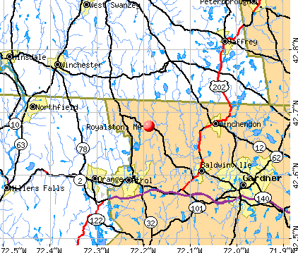
), Latitude: 42.67 N, Longitude: 72.18 W

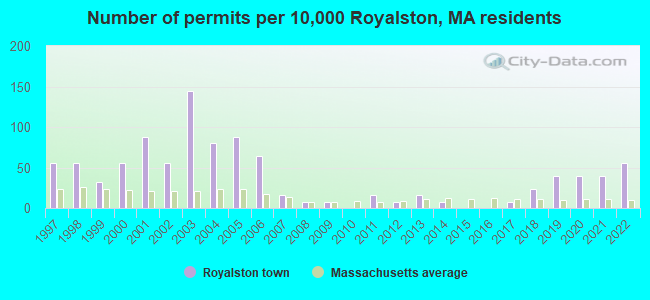
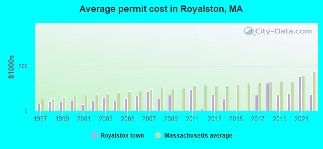
Single-family new house construction building permits:
- 2022: 7 buildings, average cost: $185,000
- 2021: 5 buildings, average cost: $380,500
- 2020: 5 buildings, average cost: $192,500
- 2019: 5 buildings, average cost: $175,100
- 2018: 3 buildings, average cost: $308,200
- 2017: 1 building, cost: $175,000
- 2014: 1 building, cost: $137,000
- 2013: 2 buildings, average cost: $185,000
- 2012: 1 building, cost: $24,000
- 2011: 2 buildings, average cost: $238,000
- 2009: 1 building, cost: $175,000
- 2008: 1 building, cost: $130,300
- 2007: 2 buildings, average cost: $215,000
- 2006: 8 buildings, average cost: $166,000
- 2005: 11 buildings, average cost: $135,700
- 2004: 10 buildings, average cost: $108,000
- 2003: 18 buildings, average cost: $147,600
- 2002: 7 buildings, average cost: $118,100
- 2001: 11 buildings, average cost: $70,100
- 2000: 7 buildings, average cost: $111,000
- 1999: 4 buildings, average cost: $100,600
- 1998: 7 buildings, average cost: $107,400
- 1997: 7 buildings, average cost: $78,900
| Here: | 2.8% |
| Massachusetts: | 3.5% |
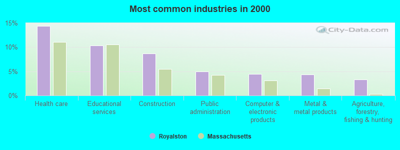
- Health care (14.3%)
- Educational services (10.3%)
- Construction (8.7%)
- Public administration (5.0%)
- Computer & electronic products (4.5%)
- Metal & metal products (4.3%)
- Agriculture, forestry, fishing & hunting (3.3%)
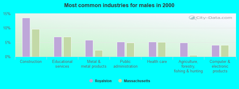
- Construction (13.5%)
- Educational services (6.9%)
- Metal & metal products (5.8%)
- Public administration (5.2%)
- Health care (5.2%)
- Agriculture, forestry, fishing & hunting (4.9%)
- Computer & electronic products (4.0%)
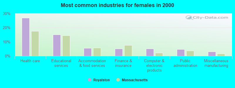
- Health care (26.9%)
- Educational services (15.0%)
- Accommodation & food services (5.5%)
- Finance & insurance (5.1%)
- Computer & electronic products (5.1%)
- Public administration (4.7%)
- Miscellaneous manufacturing (3.2%)
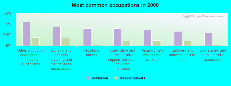
- Other production occupations, including supervisors (5.5%)
- Building and grounds cleaning and maintenance occupations (4.3%)
- Registered nurses (4.0%)
- Other office and administrative support workers, including supervisors (4.0%)
- Metal workers and plastic workers (3.7%)
- Laborers and material movers, hand (3.3%)
- Secretaries and administrative assistants (3.0%)
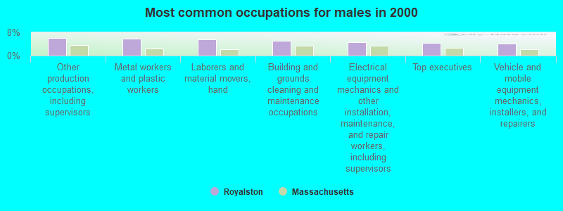
- Other production occupations, including supervisors (6.1%)
- Metal workers and plastic workers (5.8%)
- Laborers and material movers, hand (5.5%)
- Building and grounds cleaning and maintenance occupations (5.2%)
- Electrical equipment mechanics and other installation, maintenance, and repair workers, including supervisors (4.6%)
- Top executives (4.3%)
- Vehicle and mobile equipment mechanics, installers, and repairers (4.0%)
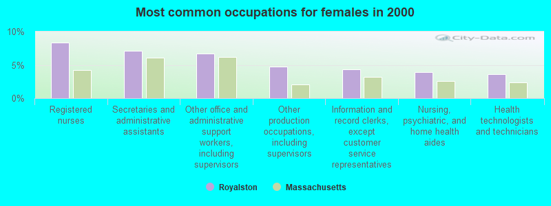
- Registered nurses (8.3%)
- Secretaries and administrative assistants (7.1%)
- Other office and administrative support workers, including supervisors (6.7%)
- Other production occupations, including supervisors (4.7%)
- Information and record clerks, except customer service representatives (4.3%)
- Nursing, psychiatric, and home health aides (4.0%)
- Health technologists and technicians (3.6%)
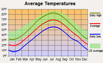
Average climate in Royalston, Massachusetts
Based on data reported by over 4,000 weather stations
(lower is better)
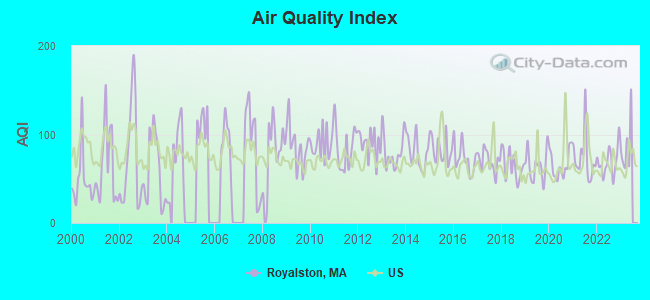
Air Quality Index (AQI) level in 2022 was 69.4. This is about average.
| City: | 69.4 |
| U.S.: | 72.6 |
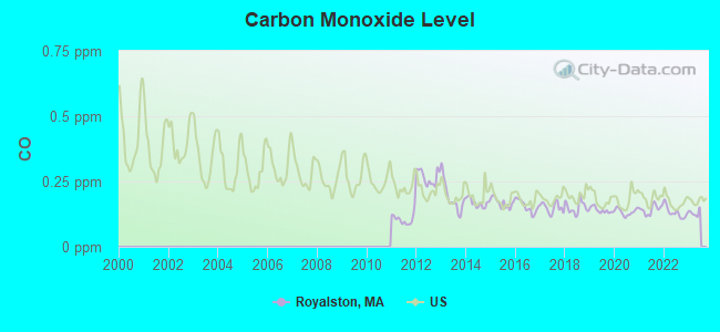
Carbon Monoxide (CO) [ppm] level in 2022 was 0.131. This is significantly better than average. Closest monitor was 18.5 miles away from the city center.
| City: | 0.131 |
| U.S.: | 0.251 |
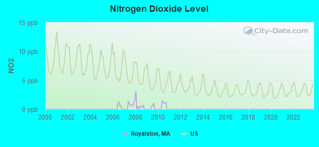
Nitrogen Dioxide (NO2) [ppb] level in 2007 was 1.02. This is significantly better than average. Closest monitor was 5.9 miles away from the city center.
| City: | 1.02 |
| U.S.: | 5.11 |
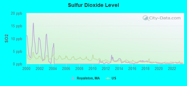
Sulfur Dioxide (SO2) [ppb] level in 2022 was 0.411. This is significantly better than average. Closest monitor was 5.9 miles away from the city center.
| City: | 0.411 |
| U.S.: | 1.515 |
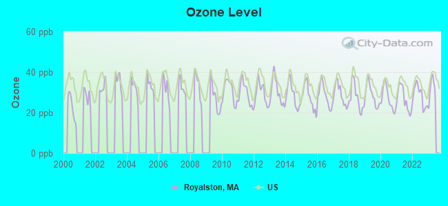
Ozone [ppb] level in 2022 was 28.2. This is about average. Closest monitor was 18.5 miles away from the city center.
| City: | 28.2 |
| U.S.: | 33.3 |
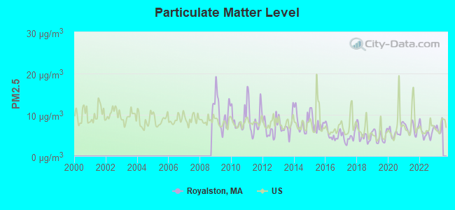
Particulate Matter (PM2.5) [µg/m3] level in 2022 was 5.77. This is significantly better than average. Closest monitor was 18.5 miles away from the city center.
| City: | 5.77 |
| U.S.: | 8.11 |
Tornado activity:
Royalston-area historical tornado activity is slightly above Massachusetts state average. It is 16% smaller than the overall U.S. average.
On 6/9/1953, a category F4 (max. wind speeds 207-260 mph) tornado 14.0 miles away from the Royalston town center killed 90 people and injured 1228 people and caused between $50,000,000 and $500,000,000 in damages.
On 6/22/1981, a category F3 (max. wind speeds 158-206 mph) tornado 14.2 miles away from the town center injured 3 people and caused between $5000 and $50,000 in damages.
Earthquake activity:
Royalston-area historical earthquake activity is significantly above Massachusetts state average. It is 70% smaller than the overall U.S. average.On 10/7/1983 at 10:18:46, a magnitude 5.3 (5.1 MB, 5.3 LG, 5.1 ML, Class: Moderate, Intensity: VI - VII) earthquake occurred 140.3 miles away from Royalston center
On 4/20/2002 at 10:50:47, a magnitude 5.3 (5.3 ML, Depth: 3.0 mi) earthquake occurred 148.2 miles away from Royalston center
On 4/20/2002 at 10:50:47, a magnitude 5.2 (5.2 MB, 4.2 MS, 5.2 MW, 5.0 MW) earthquake occurred 147.3 miles away from Royalston center
On 1/19/1982 at 00:14:42, a magnitude 4.7 (4.5 MB, 4.7 MD, 4.5 LG, Class: Light, Intensity: IV - V) earthquake occurred 64.3 miles away from Royalston center
On 10/16/2012 at 23:12:25, a magnitude 4.7 (4.7 ML, Depth: 10.0 mi) earthquake occurred 100.1 miles away from the city center
On 10/2/1994 at 11:27:22, a magnitude 3.7 (3.5 LG, 3.7 LG, Depth: 6.2 mi, Class: Light, Intensity: II - III) earthquake occurred 23.0 miles away from Royalston center
Magnitude types: regional Lg-wave magnitude (LG), body-wave magnitude (MB), duration magnitude (MD), local magnitude (ML), surface-wave magnitude (MS), moment magnitude (MW)
Natural disasters:
The number of natural disasters in Worcester County (27) is a lot greater than the US average (15).Major Disasters (Presidential) Declared: 15
Emergencies Declared: 12
Causes of natural disasters: Floods: 9, Storms: 8, Hurricanes: 6, Snowstorms: 5, Winter Storms: 4, Blizzards: 2, Snows: 2, Fire: 1, Heavy Rain: 1, Snowfall: 1, Tornado: 1, Wind: 1 (Note: some incidents may be assigned to more than one category).
Hospitals and medical centers near Royalston:
- OPEN ARMS NURSING HOME INC (Nursing Home, about 6 miles away; WINCHENDON, MA)
- ATHOL MEMORIAL HOME HEALTH AND HOSPICE (Hospital, about 6 miles away; ATHOL, MA)
- ATHOL MEMORIAL HOSPITAL Critical Access Hospitals (about 7 miles away; ATHOL, MA)
- TEMPLETON DEVELOPMENTAL CENTER (Hospital, about 7 miles away; BALDWINVILLE, MA)
- WACHUSETT MANOR NURSING HOME (Nursing Home, about 8 miles away; GARDNER, MA)
- BALDWINVILLE NURSING HOME (Nursing Home, about 8 miles away; BALDWINVILLE, MA)
- QUABBIN VALLEY HEALTHCARE (Nursing Home, about 9 miles away; ATHOL, MA)
Operable nuclear power plant near Royalston:
- 19 miles: Vermont Yankee in Vernon, VT.
Colleges/universities with over 2000 students nearest to Royalston:
- Franklin Pierce University (about 10 miles; Rindge, NH; Full-time enrollment: 2,139)
- Mount Wachusett Community College (about 12 miles; Gardner, MA; FT enrollment: 3,143)
- Keene State College (about 19 miles; Keene, NH; FT enrollment: 5,098)
- Fitchburg State University (about 21 miles; Fitchburg, MA; FT enrollment: 5,010)
- University of Massachusetts-Amherst (about 27 miles; Amherst, MA; FT enrollment: 26,583)
- Quinsigamond Community College (about 32 miles; Worcester, MA; FT enrollment: 5,877)
- Assumption College (about 32 miles; Worcester, MA; FT enrollment: 2,580)
Public elementary/middle school in Royalston:
- ROYALSTON COMMUNITY SCHOOL (Students: 112, Location: 96 WINCHENDON RD, Grades: KG-6)
Private elementary/middle school in Royalston:
- THE VILLAGE SCHOOL (Students: 54, Location: 1 TOWN DUMP RD, Grades: PK-6)
Points of interest:
Notable locations in Royalston: Royalston Fire Department Station 1 Headquarters (A), Royalston Fire Department (B). Display/hide their locations on the map
Church in Royalston: First Congregational Church (A). Display/hide its location on the map
Cemeteries: Lawrence Brook Cemetery (1), Riverside Cemetery (2), Center Cemetery (3), Newton Cemetery (4), Royalston Center Cemetery (5). Display/hide their locations on the map
Lakes, reservoirs, and swamps: Long Pond (A), Little Pond (B), Beaver Pond (C), Tully Lake (D), Paine Swamp (E), Albee Meadow (F). Display/hide their locations on the map
Streams, rivers, and creeks: Scott Brook (A), Dunham Brook (B), Kenny Brook (C), Lawrence Brook (D), Stockwell Brook (E), Towne Brook (F), Boyce Brook (G), Shepardson Brook (H). Display/hide their locations on the map
Parks in Royalston include: Birch Hill State Wildlife Management Area (1), Royalston Common Historic District (2), Millers River Wildlife Management Area (3), Lawrence Brook Wildlife Management Area (4). Display/hide their locations on the map
Birthplace of: Lysander Cutler - Union Army general, Alexander Bullock - Politician, Asahel Peck - Politician, George C. Richardson - Politician.
Drinking water stations with addresses in Royalston and their reported violations in the past:
SOUTH ROYALSTON IMPROVEMENT CORP (Population served: 275, Groundwater):Past health violations:Past monitoring violations:
- MCL, Monthly (TCR) - In SEP-2013, Contaminant: Coliform
- MCL, Monthly (TCR) - In JUL-2013, Contaminant: Coliform. Follow-up actions: St AO (w/o penalty) issued (AUG-09-2013)
- MCL, Monthly (TCR) - In JUL-2012, Contaminant: Coliform. Follow-up actions: St AO (w/o penalty) issued (2 times from JUL-30-2012 to AUG-17-2012)
- MCL, Acute (TCR) - In OCT-2010, Contaminant: Coliform. Follow-up actions: St AO (w/o penalty) issued (OCT-11-2010)
- MCL, Monthly (TCR) - In DEC-2009, Contaminant: Coliform. Follow-up actions: St AO (w/o penalty) issued (JAN-15-2010)
- MCL, Monthly (TCR) - In JUL-2006, Contaminant: Coliform. Follow-up actions: St AO (w/o penalty) issued (AUG-09-2006)
- Follow-up Or Routine LCR Tap M/R - In JUN-01-2011, Contaminant: Lead and Copper Rule. Follow-up actions: St AO (w/o penalty) issued (DEC-09-2011)
- 4 minor monitoring violations
- 24 regular monitoring violations
| This town: | 2.5 people |
| Massachusetts: | 2.5 people |
| This town: | 66.3% |
| Whole state: | 63.0% |
| This town: | 9.2% |
| Whole state: | 7.0% |
Likely homosexual households (counted as self-reported same-sex unmarried-partner households)
- Lesbian couples: 0.6% of all households
- Gay men: 0.4% of all households
| This town: | 8.7% |
| Whole state: | 9.3% |
| This town: | 2.8% |
| Whole state: | 4.4% |
For population 15 years and over in Royalston:
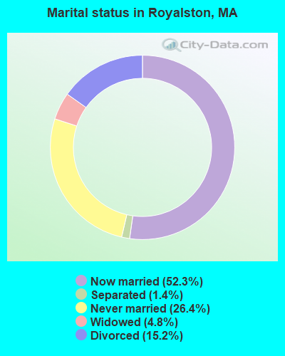
- Never married: 26.4%
- Now married: 52.3%
- Separated: 1.4%
- Widowed: 4.8%
- Divorced: 15.2%
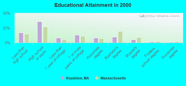
For population 25 years and over in Royalston:
- High school or higher: 82.8%
- Bachelor's degree or higher: 17.2%
- Graduate or professional degree: 7.6%
- Unemployed: 4.5%
- Mean travel time to work (commute): 35.1 minutes
| Here: | 9.8 |
| Massachusetts average: | 13.1 |


Graphs represent county-level data. Detailed 2008 Election Results
Religion statistics for Royalston, MA (based on Worcester County data)


| Religion | Adherents | Congregations |
|---|---|---|
| Catholic | 306,925 | 118 |
| Mainline Protestant | 43,326 | 171 |
| Evangelical Protestant | 37,511 | 203 |
| Other | 18,931 | 69 |
| Orthodox | 7,935 | 15 |
| Black Protestant | 497 | 6 |
| None | 383,427 | - |
Food Environment Statistics:
| This county: | 1.73 / 10,000 pop. |
| Massachusetts: | 1.98 / 10,000 pop. |
| Worcester County: | 0.05 / 10,000 pop. |
| Massachusetts: | 0.05 / 10,000 pop. |
| This county: | 1.79 / 10,000 pop. |
| Massachusetts: | 2.22 / 10,000 pop. |
| Here: | 2.22 / 10,000 pop. |
| State: | 1.77 / 10,000 pop. |
| Worcester County: | 7.27 / 10,000 pop. |
| Massachusetts: | 8.76 / 10,000 pop. |
| Worcester County: | 8.0% |
| State: | 8.1% |
| Worcester County: | 24.0% |
| Massachusetts: | 22.5% |
| Worcester County: | 16.6% |
| Massachusetts: | 16.5% |
4.71% of this county's 2021 resident taxpayers lived in other counties in 2020 ($76,229 average adjusted gross income)
| Here: | 4.71% |
| Massachusetts average: | 6.35% |
0.02% of residents moved from foreign countries ($100 average AGI)
Worcester County: 0.02% Massachusetts average: 0.01%
Top counties from which taxpayers relocated into this county between 2020 and 2021:
| from Middlesex County, MA | |
| from Norfolk County, MA | |
| from Suffolk County, MA |
4.84% of this county's 2020 resident taxpayers moved to other counties in 2021 ($87,252 average adjusted gross income)
| Here: | 4.84% |
| Massachusetts average: | 7.18% |
0.03% of residents moved to foreign countries ($199 average AGI)
Worcester County: 0.03% Massachusetts average: 0.02%
Top counties to which taxpayers relocated from this county between 2020 and 2021:
| to Middlesex County, MA | |
| to Norfolk County, MA | |
| to Suffolk County, MA |
Strongest AM radio stations in Royalston:
- WCRN (830 AM; 50 kW; WORCESTER, MA; Owner: CARTER BROADCASTING CORPORATION)
- WCAT (700 AM; daytime; 2 kW; ORANGE-ATHOL, MA; Owner: CITADEL BROADCASTING COMPANY)
- WNNZ (640 AM; 50 kW; WESTFIELD, MA; Owner: CLEAR CHANNEL BROADCASTING LICENSES, INC.)
- WVNE (760 AM; daytime; 25 kW; LEICESTER, MA; Owner: BLOUNT MASSCOM, INC.)
- WRKO (680 AM; 50 kW; BOSTON, MA; Owner: ENTERCOM BOSTON LICENSE, LLC)
- WEEI (850 AM; 50 kW; BOSTON, MA; Owner: ENTERCOM BOSTON LICENSE, LLC)
- WKOX (1200 AM; 50 kW; FRAMINGHAM, MA; Owner: CAPSTAR TX LIMITED PARTNERSHIP)
- WBIX (1060 AM; 40 kW; NATICK, MA; Owner: LANGER BROADCASTING CORPORATION)
- WALE (990 AM; 50 kW; GREENVILLE, RI; Owner: NORTH AMERICAN BROADCASTING CO., INC.)
- WIZZ (1520 AM; daytime; 10 kW; GREENFIELD, MA; Owner: P. & M. RADIO, LLC)
- WEIM (1280 AM; 5 kW; FITCHBURG, MA; Owner: LIVEAIR COMMUNICATIONS, INC.)
- WWZN (1510 AM; 50 kW; BOSTON, MA; Owner: ROSE CITY RADIO CORPORATION)
- WAMG (890 AM; 25 kW; DEDHAM, MA; Owner: MEGA COMMUNICATIONS OF DEDHAM LICENSEE, LLC)
Strongest FM radio stations in Royalston:
- WINQ (97.7 FM; WINCHENDON, MA; Owner: SAGA COMMUNICATIONS OF NEW ENGLAND, LLC)
- WAHL (99.9 FM; ATHOL, MA; Owner: CITADEL BROADCASTING COMPANY)
- WFEX (92.1 FM; PETERBOROUGH, NH; Owner: FNX BROADCASTING OF NEW HAMPSHIRE LLC)
- WYRY (104.9 FM; HINSDALE, NH; Owner: TRI-VALLEY BROADCASTING CORPORATION)
- WOQL (98.7 FM; WINCHESTER, NH; Owner: SAGA COMMUNICATIONS OF NEW HAMPSHIRE, LLC)
- WJDF (97.3 FM; ORANGE, MA; Owner: DEANE BROTHERS BROADCASTING CORP.)
- WFCR (88.5 FM; AMHERST, MA; Owner: UNIVERSITY OF MASSACHUSETTS)
- WPVQ (95.3 FM; GREENFIELD, MA; Owner: GREAT NORTHERN RADIO, L.L.C.)
- WKNE (103.7 FM; KEENE, NH; Owner: SAGA COMMUNICATIONS OF NEW ENGLAND, LLC)
- WAAF (107.3 FM; WORCESTER, MA; Owner: ENTERCOM BOSTON LICENSE, LLC)
- WHDQ (106.1 FM; CLAREMONT, NH; Owner: GREAT NORTHERN RADIO, L.L.C.)
- WEVN (90.7 FM; KEENE, NH; Owner: NEW HAMPSHIRE PUBLIC RADIO, INC.)
- WXLO (104.5 FM; FITCHBURG, MA; Owner: CITADEL BROADCASTING COMPANY)
- W293AB (106.5 FM; KEENE, NH; Owner: GREAT NORTHERN RADIO, L.L.C.)
- WEQX (102.7 FM; MANCHESTER, VT; Owner: NORTHSHIRE COMMUNICATIONS, INC.)
- WAMC-FM (90.3 FM; ALBANY, NY; Owner: WAMC)
- WJAN (95.1 FM; SUNDERLAND, VT; Owner: 6 JOHNSON ROAD LICENSES, INC.)
- WVPR (89.5 FM; WINDSOR, VT; Owner: VERMONT PUBLIC RADIO)
- WAMH (89.3 FM; AMHERST, MA; Owner: TRUSTEES OF AMHERST COLLEGE)
- WVAY (100.7 FM; WILMINGTON, VT; Owner: GREAT NORTHERN RADIO, L.L.C.)
TV broadcast stations around Royalston:
- WUNI (Channel 27; WORCESTER, MA; Owner: ENTRAVISION HOLDINGS, LLC)
- WYDN (Channel 48; WORCESTER, MA; Owner: EDUCATIONAL PUBLIC TV CORPORATION)
- WUTF (Channel 66; MARLBOROUGH, MA; Owner: TELEFUTURA BOSTON LLC)
- WEKW-TV (Channel 52; KEENE, NH; Owner: UNIVERSITY OF NEW HAMPSHIRE)
Royalston fatal accident list:
Jun 10, 2001 10:29 AM, Sr-32, Vehicles: 1, Persons: 2, Fatalities: 1
Oct 28, 2001 01:56 AM, Winchendon Rd, Vehicles: 1, Persons: 1, Fatalities: 1, Drunk persons involved: 1
Aug 8, 1999 03:00 AM, School St, Vehicles: 1, Persons: 4, Fatalities: 1
Jul 13, 1998 02:15 AM, Athol Rd, Vehicles: 1, Persons: 2, Fatalities: 1
Jul 4, 1980 09:30 PM, Vehicles: 1, Persons: 2, Fatalities: 1
- National Bridge Inventory (NBI) Statistics
- 11Number of bridges
- 49ft / 14.9mTotal length
- $6,778,000Total costs
- 4,207Total average daily traffic
- 421Total average daily truck traffic
- 6,518Total future (year 2031) average daily traffic
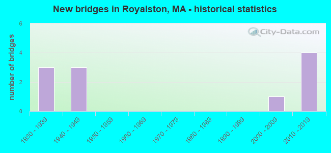
- New bridges - historical statistics
- 31930-1939
- 31940-1949
- 12000-2009
- 42010-2019
FCC Registered Antenna Towers:
1- Michael J Umano, Off Warwick Road (Lat: 42.679472 Lon: -72.203333), Type: 48.7, Structure height: 25027 m, Overall height: 42.6 m, Registrant: Industrial Tower And Wireless, LLC, Kevin.Delaney@itwllc.Com, , Marsh-field, Phone: (781) 319-1011
FCC Registered Broadcast Land Mobile Towers:
2- Warwick Road (Lat: 42.679278 Lon: -72.203639), Type: Ltower, Structure height: 42.7 m, Overall height: 45.7 m, Call Sign: WQPS828,
Assigned Frequencies: 4977.50 MHz, Grant Date: 08/18/2022, Expiration Date: 08/07/2032, Certifier: Linda Dunlavy, Registrant: Franklin Regional Council Of Governments, 12 Olive St Ste 2, Greenfield, MA 01301-3351, Phone: (413) 774-3167, Fax: (413) 774-3169, Email:
- ROYALSTON, On R.O.W. At Crossing- Baldwinville Rd(Rte 68) Fml- Mileage 355.2 (Lat: 42.627972 Lon: -72.143833), Type: Mtower, Structure height: 21 m, Call Sign: WQYZ446, Licensee ID: L00003681,
Assigned Frequencies: 161.160 MHz, 161.400 MHz, 161.250 MHz, 161.310 MHz, 160.350 MHz, Grant Date: 03/10/2017, Expiration Date: 03/10/2027, Certifier: Timothy R Kunzler, Registrant: Csx Transportation Inc, 6735 Southpoint Dr S, Suite 400, Jacksonville, FL 32216, Phone: (904) 279-6938, Email:
FCC Registered Microwave Towers:
5- MA ROY WHI, Lat: 42.632639 Lon: -72.147278, Type: Mast, Structure height: 18 m, Call Sign: WQJH296,
Assigned Frequencies: 3650.00 MHz, Grant Date: 11/07/2018, Expiration Date: 10/17/2020, Cancellation Date: 12/19/2020, Certifier: Brian R Foucher, Registrant: Business Radio Licensing, 30251 Golden Lantern, Suite E # 501, Laguna Niguel, CA 92677, Phone: (949) 348-8510, Fax: (949) 348-8514, Email:
- MA ROY STO, Lat: 42.649500 Lon: -72.160167, Type: Mtower, Structure height: 37 m, Call Sign: WQJH296,
Assigned Frequencies: 3650.00 MHz, Grant Date: 11/07/2018, Expiration Date: 10/17/2020, Cancellation Date: 12/19/2020, Certifier: Brian R Foucher, Registrant: Business Radio Licensing, 30251 Golden Lantern, Suite E # 501, Laguna Niguel, CA 92677, Phone: (949) 348-8510, Fax: (949) 348-8514, Email:
- MA ROY EMS, Lat: 42.679583 Lon: -72.203111, Type: Ltower, Structure height: 35 m, Call Sign: WQJH296,
Assigned Frequencies: 3650.00 MHz, Grant Date: 11/07/2018, Expiration Date: 10/17/2020, Cancellation Date: 12/19/2020, Certifier: Brian R Foucher, Registrant: Business Radio Licensing, 30251 Golden Lantern, Suite E # 501, Laguna Niguel, CA 92677, Phone: (949) 348-8510, Fax: (949) 348-8514, Email:
- MA ROY MIL, Lat: 42.632639 Lon: -72.156278, Type: Mtower, Structure height: 27 m, Call Sign: WQJH296,
Assigned Frequencies: 3650.00 MHz, Grant Date: 11/07/2018, Expiration Date: 10/17/2020, Cancellation Date: 12/19/2020, Certifier: Brian R Foucher, Registrant: Business Radio Licensing, 30251 Golden Lantern, Suite E # 501, Laguna Niguel, CA 92677, Phone: (949) 348-8510, Fax: (949) 348-8514, Email:
- ROYALSTON, Hwy 68 1 Mi East Of (Lat: 42.679472 Lon: -72.203333), Type: Ltower, Structure height: 42.7 m, Call Sign: WRFA392,
Assigned Frequencies: 11525.0 MHz, 11605.0 MHz, 11525.0 MHz, 11605.0 MHz, Grant Date: 01/14/2020, Expiration Date: 01/14/2030, Certifier: Daniel Neitsche, Registrant: Franklin Regional Council Of Governments, 12 Olive St Ste 2, Greenfield, MA 01301-3351, Phone: (413) 774-3167, Fax: (413) 774-3169, Email:
FCC Registered Amateur Radio Licenses:
23 (See the full list of FCC Registered Amateur Radio Licenses in Royalston)FAA Registered Aircraft:
1- Aircraft: BAKER DENNIS L TUKAN (Category: Land, Seats: 2, Weight: Up to 12,499 Pounds), Engine: ROTAX 582SER (65 HP) (2 Cycle)
N-Number: 582E, N582E, N-582E, Serial Number: 3001, Year manufactured: 2007, Airworthiness Date: 11/02/2007, Certificate Issue Date: 07/17/2018
Registrant (Individual): Dennis L Baker, 19 River Rd, Royalston, MA 01368
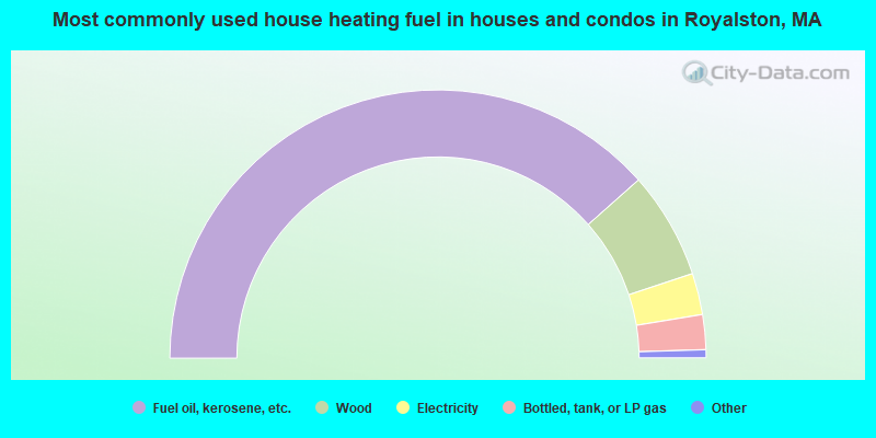
- 76.9%Fuel oil, kerosene, etc.
- 12.9%Wood
- 5.0%Electricity
- 4.2%Bottled, tank, or LP gas
- 0.5%Coal or coke
- 0.5%Other fuel
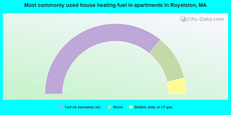
- 72.1%Fuel oil, kerosene, etc.
- 20.6%Wood
- 7.4%Bottled, tank, or LP gas
Royalston compared to Massachusetts state average:
- Median house value below state average.
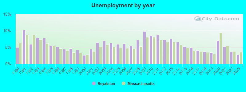
- Unemployed percentage significantly below state average.
- Black race population percentage significantly below state average.
- Hispanic race population percentage significantly below state average.
- Median age above state average.
- Foreign-born population percentage significantly below state average.
- Renting percentage significantly below state average.
- Length of stay since moving in significantly above state average.
- Number of rooms per house significantly below state average.
- House age significantly below state average.
- Percentage of population with a bachelor's degree or higher below state average.

|
Total of 1 patent application in 2008-2024.