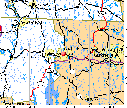
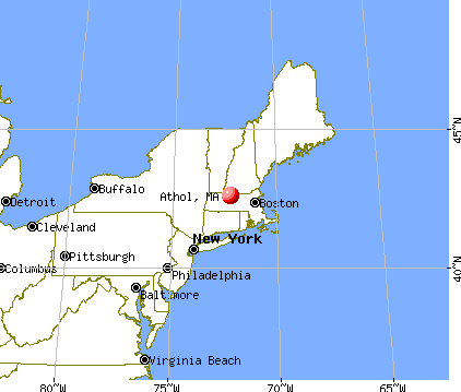
Athol, Massachusetts
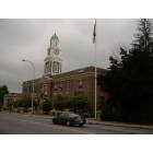
Athol: Athol Town Hall on Main Street
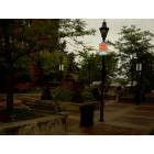
Athol: Small plaza in Athol near Athol Savings Bank
Athol

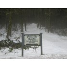
Athol: Havard Forest tour
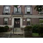
Athol: Athol Library, Athol, MA

Athol: Athol Library
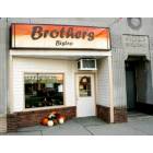
Athol: A newly opend Sanwich shop, reviving the Main street
- add
your
Submit your own pictures of this place and show them to the world
- OSM Map
- General Map
- Google Map
- MSN Map
Population change since 2000: -1.3%
| Males: 4,170 | |
| Females: 4,095 |
| Median resident age: | 38.4 years |
| Massachusetts median age: | 40.3 years |
Zip codes: 01331.
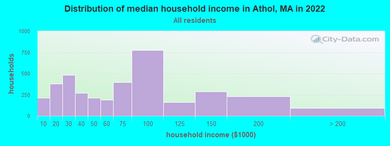
| Athol: | $61,350 |
| MA: | $94,488 |
Estimated per capita income in 2022: $27,394 (it was $16,062 in 2000)
Athol CDP income, earnings, and wages data
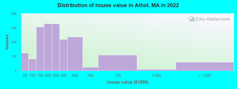
Estimated median house or condo value in 2022: $229,102 (it was $84,400 in 2000)
| Athol: | $229,102 |
| MA: | $534,700 |
Mean prices in 2022: all housing units: $240,670; detached houses: $224,466; in 2-unit structures: $264,699; in 3-to-4-unit structures: $783,150; in 5-or-more-unit structures: $556,758
Median gross rent in 2022: $1,027.
(13.8% for White Non-Hispanic residents, 10.5% for Hispanic or Latino residents, 70.0% for American Indian residents, 18.9% for other race residents, 11.6% for two or more races residents)
Detailed information about poverty and poor residents in Athol, MA
Compare current foreclosures near Athol, MA:
| Photo | Address | Area | Beds / Baths | Price | Details |
|---|---|---|---|---|---|

|
#1
Oak Ave
Athol, MA 01331
|
1,362 sq. feet
|
2 baths 4 beds |
show details | |

|
#2
Queen Lake Rd
Athol, MA 01331
|
3,416 sq. feet
|
2 baths 4 beds |
show details | |

|
#3
Ella St
Athol, MA 01331
|
1,026 sq. feet
|
1 baths 2 beds |
show details | |

|
#4
Bryant St
Athol, MA 01331
|
1,056 sq. feet
|
1 baths 4 beds |
show details | |

|
#5
Main St
Athol, MA 01331
|
1,236 sq. feet
|
1 baths 3 beds |
show details | |

|
#6
Charden Ln
Athol, MA 01331
|
1,200 sq. feet
|
1 baths 3 beds |
show details | |

|
#7
Everett St
Athol, MA 01331
|
1,080 sq. feet
|
1 baths 3 beds |
show details | |

|
#8
Templeton Rd
Athol, MA 01331
|
960 sq. feet
|
1 baths 2 beds |
show details | |

|
#9
Daniel Shays Hwy
Athol, MA 01331
|
1,736 sq. feet
|
2 baths 4 beds |
show details | |

|
#10
White Pond Rd
Athol, MA 01331
|
2,340 sq. feet
|
2 baths 5 beds |
show details |
| Photo | Address | Area | Beds / Baths | Price | Details |
|---|---|---|---|---|---|

|
#11
Chestnut St
Athol, MA 01331
|
1,503 sq. feet
|
2 baths 4 beds |
show details | |

|
#12
Kennebunk St
Athol, MA 01331
|
3,518 sq. feet
|
2 baths 4 beds |
show details | |

|
#13
Riceville Rd
Athol, MA 01331
|
1,304 sq. feet
|
2 baths 3 beds |
show details | |

|
#14
South St
Athol, MA 01331
|
1,135 sq. feet
|
1 baths 3 beds |
show details | |

|
#15
Park St
Athol, MA 01331
|
1,000 sq. feet
|
1 baths 2 beds |
show details | |

|
#16
Main St
Athol, MA 01331
|
66,835 sq. feet
|
2 baths - beds |
show details | |

|
#17
Daniel Shays Hwy Apt A-24
Athol, MA 01331
|
- sq. feet
|
- baths - beds |
show details | |

|
#18
Conant Rd
Athol, MA 01331
|
- sq. feet
|
- baths - beds |
show details | |

|
#19
Whipple Hill Rd
Winchester, NH 03470
|
1,374 sq. feet
|
2 baths 2 beds |
$379,900
|
show details |

|
#20
Parker St
Gardner, MA 01440
|
1,980 sq. feet
|
2 baths 4 beds |
$469,900
|
show details |
| Photo | Address | Area | Beds / Baths | Price | Details |
|---|---|---|---|---|---|

|
#21
Iriquois Dr
Ashburnham, MA 01430
|
2,016 sq. feet
|
2 baths 3 beds |
$369,000
|
show details |

|
#22
Lampblack Rd
Greenfield, MA 01301
|
2,078 sq. feet
|
1 baths 3 beds |
$369,900
|
show details |

|
#23
Paige St
Athol, MA 01331
|
- sq. feet
|
- baths - beds |
show details | |

|
#24
J St
Turners Falls, MA 01376
|
3,256 sq. feet
|
2 baths 7 beds |
show details | |

|
#25
Summer St
Gardner, MA 01440
|
1,893 sq. feet
|
2 baths 5 beds |
show details | |

|
#26
Chelsea St
Gardner, MA 01440
|
1,287 sq. feet
|
1 baths 3 beds |
show details | |

|
#27
Prospect St
Gardner, MA 01440
|
1,357 sq. feet
|
2 baths 3 beds |
show details | |

|
#28
Chelsea St
Gardner, MA 01440
|
1,498 sq. feet
|
1 baths 3 beds |
show details | |

|
#29
Bickford Hill Rd
Gardner, MA 01440
|
1,320 sq. feet
|
2 baths 3 beds |
show details | |

|
#30
Linwood St
Gardner, MA 01440
|
900 sq. feet
|
1 baths 3 beds |
show details |
| Photo | Address | Area | Beds / Baths | Price | Details |
|---|---|---|---|---|---|

|
#31
Mill St
Gardner, MA 01440
|
1,728 sq. feet
|
1 baths 4 beds |
show details | |

|
#32
Linwood St
Gardner, MA 01440
|
1,828 sq. feet
|
1 baths 3 beds |
show details | |

|
#33
Sawyer St
Gardner, MA 01440
|
1,747 sq. feet
|
1 baths 2 beds |
show details | |

|
#34
New Plain Rd
Northfield, MA 01360
|
2,370 sq. feet
|
2 baths 2 beds |
show details | |

|
#35
Maple St
Winchendon, MA 01475
|
1,000 sq. feet
|
1 baths 2 beds |
show details | |

|
#36
Edgell St
Gardner, MA 01440
|
4,746 sq. feet
|
2 baths 9 beds |
show details | |

|
#37
Stone St
Gardner, MA 01440
|
1,908 sq. feet
|
2 baths 3 beds |
show details | |

|
#38
Green St
Gardner, MA 01440
|
3,156 sq. feet
|
2 baths 4 beds |
show details | |

|
#39
Lakewood Ter
Gardner, MA 01440
|
3,143 sq. feet
|
4 baths 5 beds |
show details | |

|
#40
Pine St
Gardner, MA 01440
|
3,228 sq. feet
|
2 baths 4 beds |
show details |
| Photo | Address | Area | Beds / Baths | Price | Details |
|---|---|---|---|---|---|

|
#41
Pine St
Gardner, MA 01440
|
3,228 sq. feet
|
2 baths 4 beds |
show details | |

|
#42
Pratt St
Erving, MA 01344
|
3,000 sq. feet
|
4 baths 7 beds |
show details | |

|
#43
Emerald St
Gardner, MA 01440
|
1,428 sq. feet
|
1 baths 2 beds |
show details | |

|
#44
Sawyer St
Gardner, MA 01440
|
1,280 sq. feet
|
2 baths 3 beds |
show details | |

|
#45
Converse Dr
Winchendon, MA 01475
|
2,120 sq. feet
|
3 baths 3 beds |
show details | |

|
#46
Franklin St
Turners Falls, MA 01349
|
2,224 sq. feet
|
2 baths 5 beds |
show details | |

|
#47
Lord Brook Rd
Rindge, NH 03461
|
1,920 sq. feet
|
1 baths 3 beds |
show details | |

|
#48
Whitney St
Gardner, MA 01440
|
2,026 sq. feet
|
2 baths 3 beds |
show details | |

|
#49
Hale Hill Rd
Swanzey, NH 03446
|
2,976 sq. feet
|
2 baths 3 beds |
show details | |

|
Check over 1 million property listings on Foreclosure.com!
|
browse all offers | |||


- 7,74884.3%White alone
- 7688.4%Hispanic
- 4444.8%Two or more races
- 670.7%Asian alone
- 400.4%Black alone
- 400.4%Other race alone
- 90.10%American Indian alone
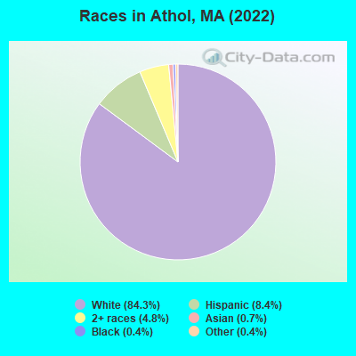
Races in Athol detailed stats: ancestries, foreign born residents, place of birth
According to our research of Massachusetts and other state lists, there were 33 registered sex offenders living in Athol, Massachusetts as of May 07, 2024.
The ratio of all residents to sex offenders in Athol is 257 to 1.
Type |
2009 |
2010 |
2011 |
2012 |
2013 |
2014 |
2015 |
2016 |
2017 |
2018 |
2019 |
2020 |
2021 |
2022 |
|---|---|---|---|---|---|---|---|---|---|---|---|---|---|---|
| Murders (per 100,000) | 0 (0.0) | 1 (8.6) | 0 (0.0) | 0 (0.0) | 0 (0.0) | 0 (0.0) | 0 (0.0) | 0 (0.0) | 0 (0.0) | 0 (0.0) | 1 (8.6) | 0 (0.0) | 0 (0.0) | 0 (0.0) |
| Rapes (per 100,000) | 6 (51.2) | 9 (77.7) | 6 (51.5) | 8 (68.2) | 6 (51.4) | 5 (42.9) | 3 (25.8) | 2 (17.2) | 7 (60.2) | 7 (59.7) | 8 (68.5) | 6 (51.4) | 7 (59.3) | 7 (58.6) |
| Robberies (per 100,000) | 4 (34.1) | 5 (43.2) | 4 (34.3) | 8 (68.2) | 3 (25.7) | 3 (25.7) | 2 (17.2) | 1 (8.6) | 3 (25.8) | 4 (34.1) | 2 (17.1) | 3 (25.7) | 3 (25.4) | 1 (8.4) |
| Assaults (per 100,000) | 38 (324.1) | 50 (431.6) | 44 (377.5) | 30 (255.8) | 43 (368.5) | 38 (326.0) | 40 (344.0) | 46 (396.1) | 49 (421.3) | 46 (392.5) | 39 (333.9) | 39 (333.8) | 35 (296.6) | 61 (511.0) |
| Burglaries (per 100,000) | 125 (1,066) | 76 (656.1) | 89 (763.6) | 88 (750.4) | 55 (471.4) | 57 (489.1) | 53 (455.8) | 46 (396.1) | 47 (404.1) | 19 (162.1) | 13 (111.3) | 14 (119.8) | 13 (110.2) | 7 (58.6) |
| Thefts (per 100,000) | 184 (1,569) | 172 (1,485) | 197 (1,690) | 162 (1,381) | 97 (831.3) | 131 (1,124) | 128 (1,101) | 158 (1,361) | 150 (1,290) | 122 (1,041) | 93 (796.3) | 87 (744.7) | 83 (703.3) | 77 (645.0) |
| Auto thefts (per 100,000) | 8 (68.2) | 4 (34.5) | 10 (85.8) | 5 (42.6) | 2 (17.1) | 3 (25.7) | 1 (8.6) | 7 (60.3) | 5 (43.0) | 3 (25.6) | 4 (34.2) | 4 (34.2) | 13 (110.2) | 9 (75.4) |
| Arson (per 100,000) | 3 (25.6) | 3 (25.9) | 1 (8.6) | 5 (42.6) | 4 (34.3) | 0 (0.0) | 0 (0.0) | 3 (25.8) | 2 (17.2) | 1 (8.5) | 1 (8.6) | 1 (8.6) | 0 (0.0) | 0 (0.0) |
| City-Data.com crime index | 258.9 | 286.8 | 254.9 | 237.4 | 190.2 | 188.5 | 171.2 | 182.6 | 223.5 | 191.5 | 186.2 | 156.5 | 159.0 | 187.6 |
The City-Data.com crime index weighs serious crimes and violent crimes more heavily. Higher means more crime, U.S. average is 246.1. It adjusts for the number of visitors and daily workers commuting into cities.
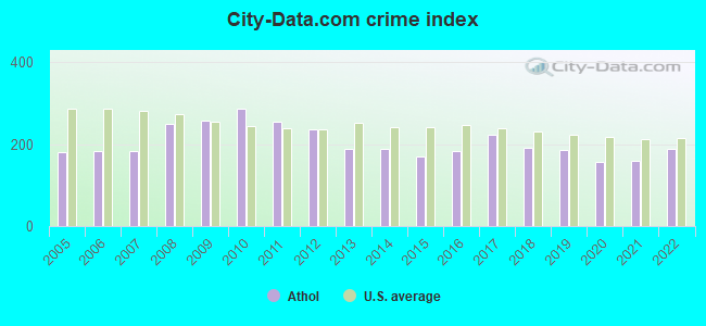
Crime rate in Athol detailed stats: murders, rapes, robberies, assaults, burglaries, thefts, arson
Full-time law enforcement employees in 2020, including police officers: 26 (19 officers - 17 male; 2 female).
| Officers per 1,000 residents here: | 1.63 |
| Massachusetts average: | 2.59 |
 Recent articles from our blog. Our writers, many of them Ph.D. graduates or candidates, create easy-to-read articles on a wide variety of topics.

 | Hillbilly Massachusetts (103 replies) |
| Massachusetts is America's Smartest State (104 replies) |
| Under $250k any Massachusetts single family house with yard (117 replies) |
| Tell me about Pittsfield! (82 replies) |
| Amazon New HQ (50k jobs), MA? (557 replies) |
| If you could choose any suburb, which one... (186 replies) |
Latest news from Athol, MA collected exclusively by city-data.com from local newspapers, TV, and radio stations
Ancestries: American (16.9%), English (7.0%), Italian (6.6%), German (6.6%), Irish (5.8%), French (5.6%).
Current Local Time: EST time zone
Incorporated in 1762
Elevation: 546 feet
Land area: 8.30 square miles.
Population density: 995 people per square mile (low).
361 residents are foreign born (2.2% Latin America, 1.0% Europe, 0.5% Asia).
| This place: | 3.9% |
| Massachusetts: | 17.6% |
Median real estate property taxes paid for housing units with mortgages in 2022: $2,745 (1.2%)
Median real estate property taxes paid for housing units with no mortgage in 2022: $2,688 (1.3%)
Nearest city with pop. 50,000+: Worcester, MA  (31.2 miles , pop. 172,648).
Nearest city with pop. 200,000+: Boston, MA (61.2 miles , pop. 589,141).
Nearest city with pop. 1,000,000+: Bronx, NY (147.5 miles , pop. 1,332,650).
Nearest cities:
Latitude: 42.59 N, Longitude: 72.23 W
Daytime population change due to commuting: -111 (-1.2%)
Workers who live and work in this place: 1,432 (34.4%)
Area code: 978
Athol, Massachusetts accommodation & food services, waste management - Economy and Business Data
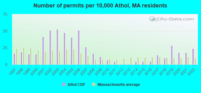
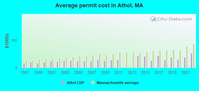
Single-family new house construction building permits:
- 2022: 20 buildings, average cost: $262,700
- 2021: 15 buildings, average cost: $190,500
- 2020: 15 buildings, average cost: $153,700
- 2019: 24 buildings, average cost: $193,500
- 2018: 8 buildings, average cost: $142,100
- 2017: 12 buildings, average cost: $221,100
- 2016: 4 buildings, average cost: $134,200
- 2015: 4 buildings, average cost: $209,500
- 2014: 4 buildings, average cost: $223,400
- 2011: 4 buildings, average cost: $142,700
- 2010: 6 buildings, average cost: $142,700
- 2009: 10 buildings, average cost: $128,700
- 2008: 14 buildings, average cost: $149,000
- 2007: 22 buildings, average cost: $122,300
- 2006: 43 buildings, average cost: $120,600
- 2005: 34 buildings, average cost: $124,700
- 2004: 40 buildings, average cost: $135,900
- 2003: 44 buildings, average cost: $133,100
- 2002: 43 buildings, average cost: $113,900
- 2001: 35 buildings, average cost: $127,900
- 2000: 13 buildings, average cost: $106,100
- 1999: 13 buildings, average cost: $86,000
- 1998: 16 buildings, average cost: $105,200
- 1997: 14 buildings, average cost: $86,000
| Here: | 3.6% |
| Massachusetts: | 3.5% |
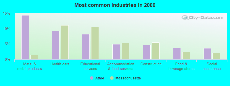
- Metal & metal products (14.4%)
- Health care (9.3%)
- Educational services (8.2%)
- Accommodation & food services (4.9%)
- Construction (4.7%)
- Food & beverage stores (3.7%)
- Social assistance (3.6%)
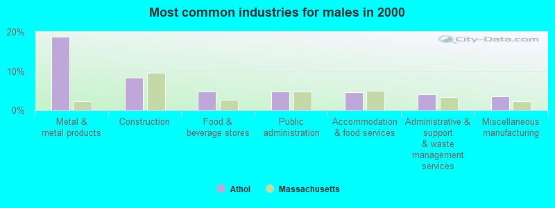
- Metal & metal products (18.8%)
- Construction (8.4%)
- Food & beverage stores (4.8%)
- Public administration (4.7%)
- Accommodation & food services (4.5%)
- Administrative & support & waste management services (4.0%)
- Miscellaneous manufacturing (3.6%)
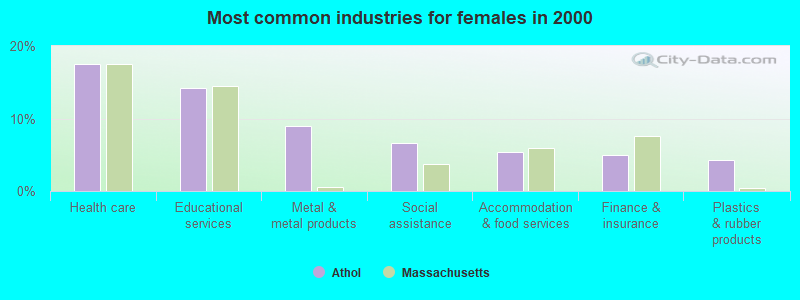
- Health care (17.5%)
- Educational services (14.2%)
- Metal & metal products (9.0%)
- Social assistance (6.6%)
- Accommodation & food services (5.4%)
- Finance & insurance (4.9%)
- Plastics & rubber products (4.2%)

- Metal workers and plastic workers (11.4%)
- Other production occupations, including supervisors (8.8%)
- Building and grounds cleaning and maintenance occupations (3.6%)
- Nursing, psychiatric, and home health aides (3.1%)
- Preschool, kindergarten, elementary, and middle school teachers (2.9%)
- Other office and administrative support workers, including supervisors (2.8%)
- Material recording, scheduling, dispatching, and distributing workers (2.7%)
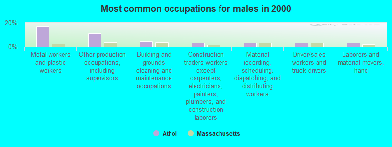
- Metal workers and plastic workers (16.7%)
- Other production occupations, including supervisors (11.0%)
- Building and grounds cleaning and maintenance occupations (4.5%)
- Construction traders workers except carpenters, electricians, painters, plumbers, and construction laborers (3.4%)
- Material recording, scheduling, dispatching, and distributing workers (3.4%)
- Driver/sales workers and truck drivers (3.3%)
- Laborers and material movers, hand (3.2%)

- Nursing, psychiatric, and home health aides (6.1%)
- Preschool, kindergarten, elementary, and middle school teachers (6.1%)
- Other production occupations, including supervisors (6.1%)
- Other office and administrative support workers, including supervisors (5.1%)
- Metal workers and plastic workers (5.0%)
- Information and record clerks, except customer service representatives (4.5%)
- Secretaries and administrative assistants (3.5%)
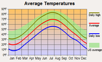
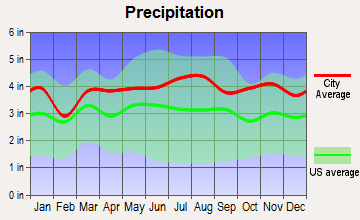
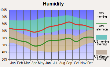
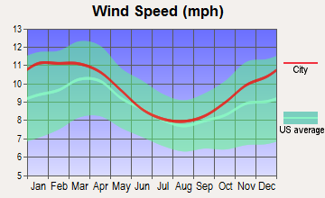
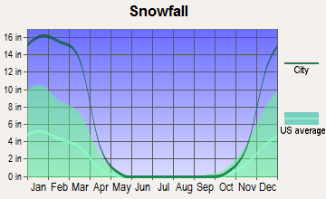
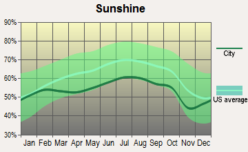
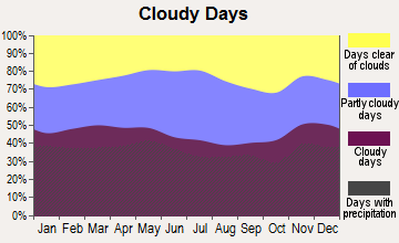
Average climate in Athol, Massachusetts
Based on data reported by over 4,000 weather stations
|
|


(lower is better)
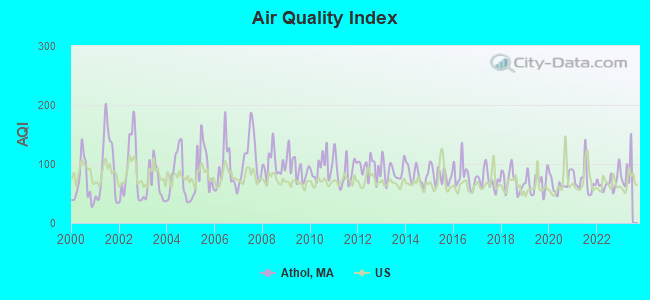
Air Quality Index (AQI) level in 2022 was 69.2. This is about average.
| City: | 69.2 |
| U.S.: | 72.6 |
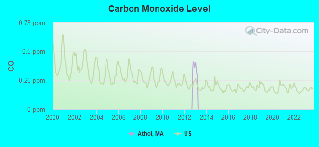
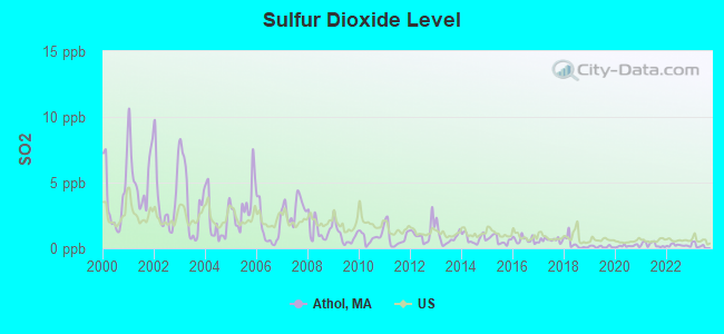
Sulfur Dioxide (SO2) [ppb] level in 2022 was 0.216. This is significantly better than average. Closest monitor was 0.2 miles away from the city center.
| City: | 0.216 |
| U.S.: | 1.515 |
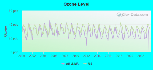
Ozone [ppb] level in 2022 was 26.8. This is better than average. Closest monitor was 15.2 miles away from the city center.
| City: | 26.8 |
| U.S.: | 33.3 |
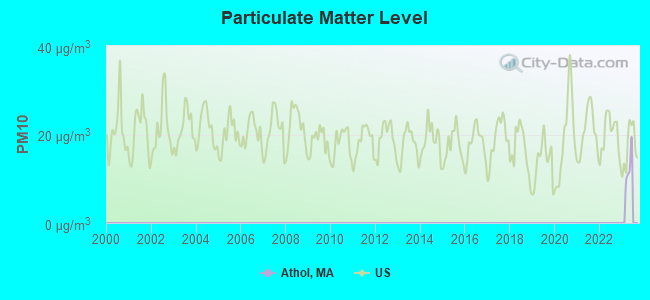
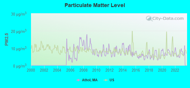
Particulate Matter (PM2.5) [µg/m3] level in 2022 was 6.74. This is better than average. Closest monitor was 18.7 miles away from the city center.
| City: | 6.74 |
| U.S.: | 8.11 |
Tornado activity:
Athol-area historical tornado activity is above Massachusetts state average. It is 13% smaller than the overall U.S. average.
On 6/9/1953, a category F4 (max. wind speeds 207-260 mph) tornado 9.0 miles away from the Athol place center killed 90 people and injured 1228 people and caused between $50,000,000 and $500,000,000 in damages.
On 6/22/1981, a category F3 (max. wind speeds 158-206 mph) tornado 12.0 miles away from the place center injured 3 people and caused between $5000 and $50,000 in damages.
Earthquake activity:
Athol-area historical earthquake activity is significantly above Massachusetts state average. It is 70% smaller than the overall U.S. average.On 10/7/1983 at 10:18:46, a magnitude 5.3 (5.1 MB, 5.3 LG, 5.1 ML, Class: Moderate, Intensity: VI - VII) earthquake occurred 142.0 miles away from the city center
On 4/20/2002 at 10:50:47, a magnitude 5.3 (5.3 ML, Depth: 3.0 mi) earthquake occurred 151.8 miles away from Athol center
On 4/20/2002 at 10:50:47, a magnitude 5.2 (5.2 MB, 4.2 MS, 5.2 MW, 5.0 MW) earthquake occurred 150.8 miles away from the city center
On 1/19/1982 at 00:14:42, a magnitude 4.7 (4.5 MB, 4.7 MD, 4.5 LG, Class: Light, Intensity: IV - V) earthquake occurred 70.4 miles away from the city center
On 10/16/2012 at 23:12:25, a magnitude 4.7 (4.7 ML, Depth: 10.0 mi) earthquake occurred 105.6 miles away from Athol center
On 10/2/1994 at 11:27:22, a magnitude 3.7 (3.5 LG, 3.7 LG, Depth: 6.2 mi, Class: Light, Intensity: II - III) earthquake occurred 17.1 miles away from the city center
Magnitude types: regional Lg-wave magnitude (LG), body-wave magnitude (MB), duration magnitude (MD), local magnitude (ML), surface-wave magnitude (MS), moment magnitude (MW)
Natural disasters:
The number of natural disasters in Worcester County (27) is a lot greater than the US average (15).Major Disasters (Presidential) Declared: 15
Emergencies Declared: 12
Causes of natural disasters: Floods: 9, Storms: 8, Hurricanes: 6, Snowstorms: 5, Winter Storms: 4, Blizzards: 2, Snows: 2, Fire: 1, Heavy Rain: 1, Snowfall: 1, Tornado: 1, Wind: 1 (Note: some incidents may be assigned to more than one category).

Main business address for: STARRETT L S CO (CUTLERY, HANDTOOLS & GENERAL HARDWARE).
Hospitals and medical centers in Athol:
Operable nuclear power plant near Athol:
- 20 miles: Vermont Yankee in Vernon, VT.
Colleges/universities with over 2000 students nearest to Athol:
- Mount Wachusett Community College (about 13 miles; Gardner, MA; Full-time enrollment: 3,143)
- Franklin Pierce University (about 16 miles; Rindge, NH; FT enrollment: 2,139)
- University of Massachusetts-Amherst (about 21 miles; Amherst, MA; FT enrollment: 26,583)
- Fitchburg State University (about 23 miles; Fitchburg, MA; FT enrollment: 5,010)
- Keene State College (about 24 miles; Keene, NH; FT enrollment: 5,098)
- Smith College (about 29 miles; Northampton, MA; FT enrollment: 3,549)
- Assumption College (about 30 miles; Worcester, MA; FT enrollment: 2,580)
Public high school in Athol:
- ATHOL HIGH (Students: 539, Location: 2363 MAIN STREET, Grades: 9-12)
Public elementary/middle schools in Athol:
- ATHOL-ROYALSTON MIDDLE SCHOOL (Students: 478, Location: 1062 PLEASANT STREET, Grades: 5-8)
- PLEASANT STREET (Students: 280, Location: 1060 PLEASANT STREET, Grades: PK-4)
- RIVERBEND-SANDERS STREET SCHOOL (Location: 174 RIVERBEND STREET, Grades: KG-4)
Points of interest:
Notable locations in Athol: Athol Fire Department Station 2 Headquarters (A), Athol Fire Department Station 1 (B), Old Town Hall (C), Memorial Hall (D). Display/hide their locations on the map
Main business address in Athol: STARRETT L S CO (A). Display/hide its location on the map
Churches in Athol include: Kingdom Hall of Jehovahs Witnesses (A), Starrett Memorial Methodist Church (B), Saint Johns Episcopal Church (C), Saint Francis of Assisi Church (D), First Church Unitarian Church (E), Athol-Orange Baptist Church (F). Display/hide their locations on the map
Cemeteries: Mount Pleasant Cemetery (1), Highland Cemetery (2), Calvary Cemetery (3), Silver Lake Cemetery (4). Display/hide their locations on the map
Lakes and reservoirs: Duck Pond (A), Silver Lake (B), Summer Street Reservoir (C), Sportsmans Pond (D), Millers River Reservoir (E). Display/hide their locations on the map
Streams, rivers, and creeks: Ice Company Branch (A), West Brook (B), Company Brook (C), Mill Brook (D), Tully River (E). Display/hide their locations on the map
Park in Athol: Fish Park (1). Display/hide its location on the map
Hotel: King Phillip Motel (35 State Road).
Birthplace of: Lysander Spooner - Anarchist, Alice Spencer Geddes Lloyd - Social reformer who founded Alice Lloyd College, Asa Drury - Educator, Charles Starrett - Actor, George Henry Hoyt - Union Army officer, Ginery Twichell - Politician, Gregory Gibson - Writer, H. Warner Munn - Fantasy writer, Jimmy Barrett - Baseball player, Alf Cobb - Player of Football.
Drinking water stations with addresses in Athol that have no violations reported:
- ATHOL DPW WATER DIVISION (Population served: 10,025, Primary Water Source Type: Groundwater)
| This place: | 2.5 people |
| Massachusetts: | 2.5 people |
| This place: | 61.9% |
| Whole state: | 63.0% |
| This place: | 10.9% |
| Whole state: | 7.0% |
Likely homosexual households (counted as self-reported same-sex unmarried-partner households)
- Lesbian couples: 0.5% of all households
- Gay men: 0.3% of all households
2 people in other noninstitutional facilities in 2010
People in group quarters in Athol in 2000:
- 27 people in other nonhousehold living situations
- 10 people in religious group quarters
- 4 people in homes for the mentally retarded
- 3 people in homes for the mentally ill
Banks with branches in Athol (2011 data):
- Athol Savings Bank: at 444 Main Street, Athol Branch, Main Street Branch. Info updated 2008/03/03: Bank assets: $327.4 mil, Deposits: $277.2 mil, local headquarters, positive income, Mortgage Lending Specialization, 8 total offices
- Hometown Bank, A Cooperative Bank: Athol-Clinton Branch at 90 Exchange Street, branch established on 1889/01/01. Info updated 2011/04/11: Bank assets: $301.7 mil, Deposits: $250.6 mil, headquarters in Webster, MA, positive income, Commercial Lending Specialization, 5 total offices
- TD Bank, National Association: Athol Branch at 2156 Main Street, branch established on 1955/06/23. Info updated 2010/10/04: Bank assets: $188,912.6 mil, Deposits: $153,149.8 mil, headquarters in Wilmington, DE, positive income, 1314 total offices, Holding Company: Toronto-Dominion Bank, The
For population 15 years and over in Athol:
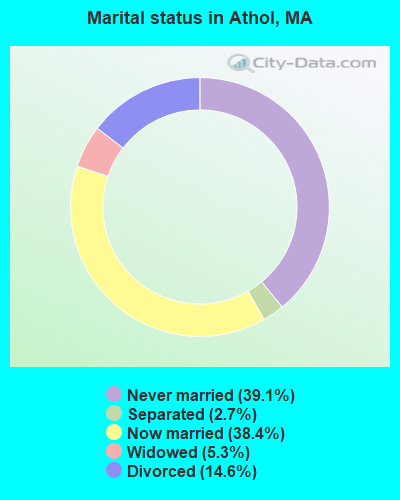
- Never married: 39.1%
- Now married: 38.4%
- Separated: 2.7%
- Widowed: 5.3%
- Divorced: 14.6%
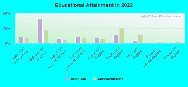
For population 25 years and over in Athol:
- High school or higher: 89.8%
- Bachelor's degree or higher: 21.0%
- Graduate or professional degree: 6.1%
- Unemployed: 5.5%
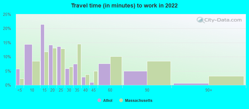
- Mean travel time to work (commute): 22.7 minutes

| Here: | 9.4 |
| Massachusetts average: | 13.0 |


Graphs represent county-level data. Detailed 2008 Election Results
Religion statistics for Athol, MA (based on Worcester County data)


| Religion | Adherents | Congregations |
|---|---|---|
| Catholic | 306,925 | 118 |
| Mainline Protestant | 43,326 | 171 |
| Evangelical Protestant | 37,511 | 203 |
| Other | 18,931 | 69 |
| Orthodox | 7,935 | 15 |
| Black Protestant | 497 | 6 |
| None | 383,427 | - |
Food Environment Statistics:
| Worcester County: | 1.73 / 10,000 pop. |
| Massachusetts: | 1.98 / 10,000 pop. |
| This county: | 0.05 / 10,000 pop. |
| State: | 0.05 / 10,000 pop. |
| Worcester County: | 1.79 / 10,000 pop. |
| Massachusetts: | 2.22 / 10,000 pop. |
| Worcester County: | 2.22 / 10,000 pop. |
| State: | 1.77 / 10,000 pop. |
| Here: | 7.27 / 10,000 pop. |
| State: | 8.76 / 10,000 pop. |
| This county: | 8.0% |
| Massachusetts: | 8.1% |
| Worcester County: | 24.0% |
| Massachusetts: | 22.5% |
| This county: | 16.6% |
| State: | 16.5% |
Health and Nutrition:
| Athol: | 50.0% |
| Massachusetts: | 50.5% |
| Athol: | 47.4% |
| Massachusetts: | 48.0% |
| Here: | 28.6 |
| State: | 28.4 |
| Athol: | 23.8% |
| Massachusetts: | 20.7% |
| This city: | 10.2% |
| Massachusetts: | 10.4% |
| Here: | 6.9 |
| State: | 6.8 |
| This city: | 33.5% |
| State: | 33.4% |
| This city: | 56.8% |
| State: | 57.1% |
| This city: | 77.9% |
| Massachusetts: | 79.2% |
More about Health and Nutrition of Athol, MA Residents
4.71% of this county's 2021 resident taxpayers lived in other counties in 2020 ($76,229 average adjusted gross income)
| Here: | 4.71% |
| Massachusetts average: | 6.35% |
0.02% of residents moved from foreign countries ($100 average AGI)
Worcester County: 0.02% Massachusetts average: 0.01%
Top counties from which taxpayers relocated into this county between 2020 and 2021:
| from Middlesex County, MA | |
| from Norfolk County, MA | |
| from Suffolk County, MA |
4.84% of this county's 2020 resident taxpayers moved to other counties in 2021 ($87,252 average adjusted gross income)
| Here: | 4.84% |
| Massachusetts average: | 7.18% |
0.03% of residents moved to foreign countries ($199 average AGI)
Worcester County: 0.03% Massachusetts average: 0.02%
Top counties to which taxpayers relocated from this county between 2020 and 2021:
| to Middlesex County, MA | |
| to Norfolk County, MA | |
| to Suffolk County, MA |
| Businesses in Athol, MA | ||||
| Name | Count | Name | Count | |
|---|---|---|---|---|
| Advance Auto Parts | 1 | McDonald's | 1 | |
| CVS | 1 | RadioShack | 1 | |
| Curves | 1 | Rite Aid | 1 | |
| Dunkin Donuts | 2 | U-Haul | 1 | |
| H&R Block | 1 | YMCA | 2 | |
| Lane Furniture | 1 | |||
Strongest AM radio stations in Athol:
- WCAT (700 AM; daytime; 2 kW; ORANGE-ATHOL, MA; Owner: CITADEL BROADCASTING COMPANY)
- WCRN (830 AM; 50 kW; WORCESTER, MA; Owner: CARTER BROADCASTING CORPORATION)
- WVNE (760 AM; daytime; 25 kW; LEICESTER, MA; Owner: BLOUNT MASSCOM, INC.)
- WNNZ (640 AM; 50 kW; WESTFIELD, MA; Owner: CLEAR CHANNEL BROADCASTING LICENSES, INC.)
- WRKO (680 AM; 50 kW; BOSTON, MA; Owner: ENTERCOM BOSTON LICENSE, LLC)
- WKOX (1200 AM; 50 kW; FRAMINGHAM, MA; Owner: CAPSTAR TX LIMITED PARTNERSHIP)
- WEEI (850 AM; 50 kW; BOSTON, MA; Owner: ENTERCOM BOSTON LICENSE, LLC)
- WIZZ (1520 AM; daytime; 10 kW; GREENFIELD, MA; Owner: P. & M. RADIO, LLC)
- WBIX (1060 AM; 40 kW; NATICK, MA; Owner: LANGER BROADCASTING CORPORATION)
- WALE (990 AM; 50 kW; GREENVILLE, RI; Owner: NORTH AMERICAN BROADCASTING CO., INC.)
- WAMG (890 AM; 25 kW; DEDHAM, MA; Owner: MEGA COMMUNICATIONS OF DEDHAM LICENSEE, LLC)
- WTIC (1080 AM; 50 kW; HARTFORD, CT; Owner: INFINITY RADIO OPERATIONS INC.)
- WWZN (1510 AM; 50 kW; BOSTON, MA; Owner: ROSE CITY RADIO CORPORATION)
Strongest FM radio stations in Athol:
- WAHL (99.9 FM; ATHOL, MA; Owner: CITADEL BROADCASTING COMPANY)
- WJDF (97.3 FM; ORANGE, MA; Owner: DEANE BROTHERS BROADCASTING CORP.)
- WFCR (88.5 FM; AMHERST, MA; Owner: UNIVERSITY OF MASSACHUSETTS)
- WFEX (92.1 FM; PETERBOROUGH, NH; Owner: FNX BROADCASTING OF NEW HAMPSHIRE LLC)
- WINQ (97.7 FM; WINCHENDON, MA; Owner: SAGA COMMUNICATIONS OF NEW ENGLAND, LLC)
- WYRY (104.9 FM; HINSDALE, NH; Owner: TRI-VALLEY BROADCASTING CORPORATION)
- WAMH (89.3 FM; AMHERST, MA; Owner: TRUSTEES OF AMHERST COLLEGE)
- WAAF (107.3 FM; WORCESTER, MA; Owner: ENTERCOM BOSTON LICENSE, LLC)
- WPVQ (95.3 FM; GREENFIELD, MA; Owner: GREAT NORTHERN RADIO, L.L.C.)
- WOQL (98.7 FM; WINCHESTER, NH; Owner: SAGA COMMUNICATIONS OF NEW HAMPSHIRE, LLC)
- WXLO (104.5 FM; FITCHBURG, MA; Owner: CITADEL BROADCASTING COMPANY)
- WSRS (96.1 FM; WORCESTER, MA; Owner: CAPSTAR TX LIMITED PARTNERSHIP)
- WAMC-FM (90.3 FM; ALBANY, NY; Owner: WAMC)
- WEQX (102.7 FM; MANCHESTER, VT; Owner: NORTHSHIRE COMMUNICATIONS, INC.)
- WHDQ (106.1 FM; CLAREMONT, NH; Owner: GREAT NORTHERN RADIO, L.L.C.)
- WJAN (95.1 FM; SUNDERLAND, VT; Owner: 6 JOHNSON ROAD LICENSES, INC.)
- W246AM (97.1 FM; AMHERST, MA; Owner: GREAT NORTHERN RADIO, LLC)
- WKNE (103.7 FM; KEENE, NH; Owner: SAGA COMMUNICATIONS OF NEW ENGLAND, LLC)
- WVAY (100.7 FM; WILMINGTON, VT; Owner: GREAT NORTHERN RADIO, L.L.C.)
- WHYN-FM (93.1 FM; SPRINGFIELD, MA; Owner: CLEAR CHANNEL BROADCASTING LICENSES, INC.)
TV broadcast stations around Athol:
- WUNI (Channel 27; WORCESTER, MA; Owner: ENTRAVISION HOLDINGS, LLC)
- WYDN (Channel 48; WORCESTER, MA; Owner: EDUCATIONAL PUBLIC TV CORPORATION)
- WUTF (Channel 66; MARLBOROUGH, MA; Owner: TELEFUTURA BOSTON LLC)
- National Bridge Inventory (NBI) Statistics
- 26Number of bridges
- 210ft / 63.9mTotal length
- $31,382,000Total costs
- 154,971Total average daily traffic
- 12,466Total average daily truck traffic
- 182,798Total future (year 2031) average daily traffic
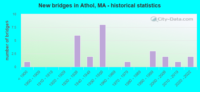
- New bridges - historical statistics
- 1Before 1900
- 61930-1939
- 21940-1949
- 81950-1959
- 11970-1979
- 31990-1999
- 22000-2009
- 12010-2019
- 22020-2022
FCC Registered Cell Phone Towers:
1 (See the full list of FCC Registered Cell Phone Towers in Athol)FCC Registered Antenna Towers:
46 (See the full list of FCC Registered Antenna Towers)FCC Registered Private Land Mobile Towers:
4 (See the full list of FCC Registered Private Land Mobile Towers in Athol, MA)FCC Registered Broadcast Land Mobile Towers:
10 (See the full list of FCC Registered Broadcast Land Mobile Towers)FCC Registered Microwave Towers:
7 (See the full list of FCC Registered Microwave Towers in this town)FCC Registered Paging Towers:
6 (See the full list of FCC Registered Paging Towers)FCC Registered Maritime Coast & Aviation Ground Towers:
1 (See the full list of FCC Registered Maritime Coast & Aviation Ground Towers)FCC Registered Amateur Radio Licenses:
68 (See the full list of FCC Registered Amateur Radio Licenses in Athol)FAA Registered Aircraft:
7- Aircraft: CESSNA 182E (Category: Land, Seats: 4, Weight: Up to 12,499 Pounds, Speed: 119 mph), Engine: CONT MOTOR O-470 SERIES (230 HP) (Reciprocating)
N-Number: 2998Y, N2998Y, N-2998Y, Serial Number: 18253998, Year manufactured: 1962, Airworthiness Date: 03/28/1962, Certificate Issue Date: 10/02/2002
Registrant (Individual): Peter Reynolds, 680 Vine St, Athol, MA 01331 - Aircraft: TAYLORCRAFT BL-65 (Category: Land, Seats: 2, Weight: Up to 12,499 Pounds, Speed: 78 mph), Engine: LYCOMING 0-145B SERIES (65 HP) (Reciprocating)
N-Number: 33999, N33999, N-33999, Serial Number: 2851, Year manufactured: 1941, Airworthiness Date: 07/27/1955, Certificate Issue Date: 06/11/1987
Registrant (Corporation): Athol Orange Aero Club Inc, Po Box 327, Athol, MA 01331 - Aircraft: DUGAS DAVID J Q2 (Category: Land, Seats: 2, Weight: Up to 12,499 Pounds), Engine: REVMASTER 2100 (65 HP) (Reciprocating)
N-Number: 68DD, N68DD, N-68DD, Serial Number: 2746, Year manufactured: 2000, Airworthiness Date: 03/24/2000, Certificate Issue Date: 01/21/1993
Registrant (Individual): David J Dugas, 145 Silver Lake St, Athol, MA 01331 - Aircraft: CESSNA 150A (Category: Land, Seats: 2, Weight: Up to 12,499 Pounds, Speed: 90 mph), Engine: CONT MOTOR 0-200 SERIES (100 HP) (Reciprocating)
N-Number: 7145X, N7145X, N-7145X, Serial Number: 15059245, Year manufactured: 1961, Airworthiness Date: 05/27/1961, Certificate Issue Date: 01/06/1975
Registrant (Corporation): Athol Orange Aero Club Inc, Po Box 327, Athol, MA 01331 - Aircraft: CESSNA 172L (Category: Land, Seats: 4, Weight: Up to 12,499 Pounds, Speed: 105 mph), Engine: LYCOMING 0-320 SERIES (180 HP) (Reciprocating)
N-Number: 7210Q, N7210Q, N-7210Q, Serial Number: 17260510, Year manufactured: 1972, Airworthiness Date: 03/13/1972, Certificate Issue Date: 08/30/1990
Registrant (Corporation): Athol Orange Aero Club Inc, Po Box 327, Athol, MA 01331 - Aircraft: AERONCA 7AC (Category: Land, Seats: 2, Weight: Up to 12,499 Pounds, Speed: 90 mph), Engine: CONT MOTOR A&C65 SERIES (65 HP) (Reciprocating)
N-Number: 83563, N83563, N-83563, Serial Number: 7AC-2241, Year manufactured: 1946, Airworthiness Date: 06/13/1956, Certificate Issue Date: 07/11/1946
Registrant (Corporation): Athol Orange Aero Club Inc, Po Box 327, Athol, MA 01331 - Aircraft: NORTH AMERICAN NAVION (Category: Land, Seats: 5, Weight: Up to 12,499 Pounds, Speed: 126 mph), Engine: CONT MOTOR E225-4 (225 HP) (Reciprocating)
N-Number: 8618H, N8618H, N-8618H, Serial Number: NAV-4-583, Year manufactured: 1947, Airworthiness Date: 08/05/1955, Certificate Issue Date: 09/20/2017
Registrant (Individual): Michael J Ascolese, 867 Carpenter Rd, Athol, MA 01331
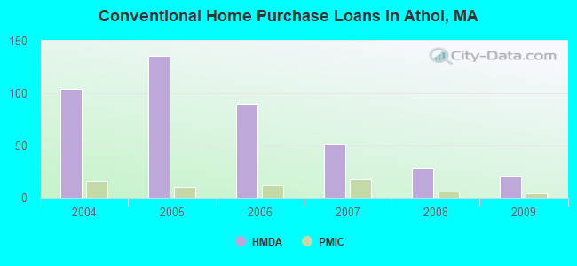
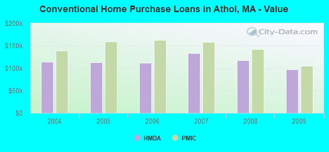
| Home Mortgage Disclosure Act Aggregated Statistics For Year 2009 (Based on 3 partial tracts) | ||||||||||||
| A) FHA, FSA/RHS & VA Home Purchase Loans | B) Conventional Home Purchase Loans | C) Refinancings | D) Home Improvement Loans | F) Non-occupant Loans on < 5 Family Dwellings (A B C & D) | G) Loans On Manufactured Home Dwelling (A B C & D) | |||||||
|---|---|---|---|---|---|---|---|---|---|---|---|---|
| Number | Average Value | Number | Average Value | Number | Average Value | Number | Average Value | Number | Average Value | Number | Average Value | |
| LOANS ORIGINATED | 20 | $124,846 | 20 | $97,670 | 60 | $130,740 | 17 | $25,768 | 7 | $69,171 | 2 | $35,870 |
| APPLICATIONS APPROVED, NOT ACCEPTED | 1 | $125,900 | 2 | $89,925 | 3 | $101,680 | 0 | $0 | 0 | $0 | 1 | $73,170 |
| APPLICATIONS DENIED | 3 | $139,553 | 2 | $115,920 | 20 | $148,073 | 5 | $60,076 | 2 | $37,290 | 0 | $0 |
| APPLICATIONS WITHDRAWN | 3 | $113,850 | 1 | $63,320 | 14 | $148,837 | 2 | $37,610 | 1 | $20,630 | 0 | $0 |
| FILES CLOSED FOR INCOMPLETENESS | 1 | $94,680 | 1 | $72,610 | 4 | $135,915 | 0 | $0 | 0 | $0 | 0 | $0 |
Detailed HMDA statistics for the following Tracts: 7031.00 , 7032.00, 7033.00
| Private Mortgage Insurance Companies Aggregated Statistics For Year 2009 (Based on 3 partial tracts) | ||||
| A) Conventional Home Purchase Loans | B) Refinancings | |||
|---|---|---|---|---|
| Number | Average Value | Number | Average Value | |
| LOANS ORIGINATED | 4 | $104,558 | 2 | $157,905 |
| APPLICATIONS APPROVED, NOT ACCEPTED | 2 | $181,485 | 1 | $89,770 |
| APPLICATIONS DENIED | 1 | $108,310 | 1 | $73,290 |
| APPLICATIONS WITHDRAWN | 0 | $0 | 1 | $48,780 |
| FILES CLOSED FOR INCOMPLETENESS | 0 | $0 | 0 | $0 |
Detailed PMIC statistics for the following Tracts: 7031.00 , 7032.00, 7033.00
2002 - 2018 National Fire Incident Reporting System (NFIRS) incidents
- Fire incident types reported to NFIRS in Athol, MA
- 57744.8%Structure Fires
- 44334.4%Outside Fires
- 13610.6%Mobile Property/Vehicle Fires
- 13110.2%Other
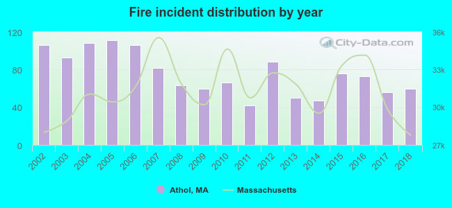 According to the data from the years 2002 - 2018 the average number of fire incidents per year is 76. The highest number of reported fire incidents - 111 took place in 2005, and the least - 42 in 2011. The data has a dropping trend.
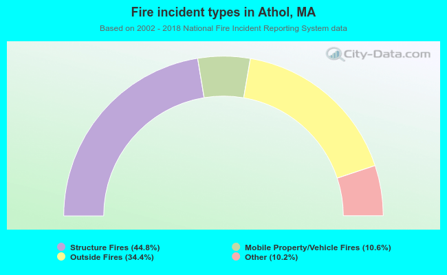 When looking into fire subcategories, the most reports belonged to: Structure Fires (44.8%), and Outside Fires (34.4%).
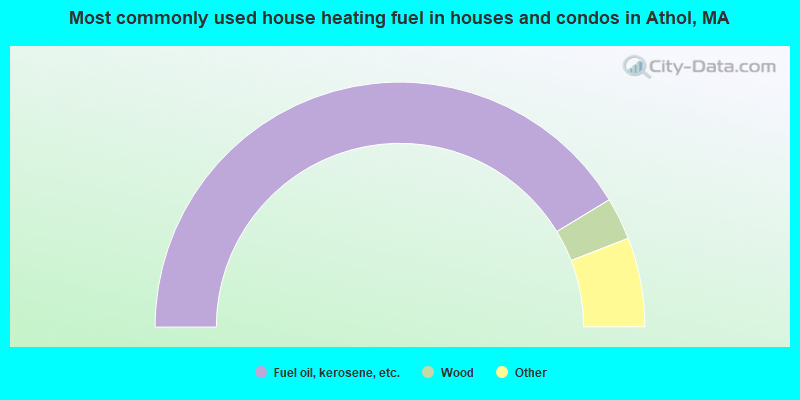
- 82.7%Fuel oil, kerosene, etc.
- 5.6%Wood
- 3.4%Electricity
- 3.1%Bottled, tank, or LP gas
- 3.0%Utility gas
- 1.8%Other fuel
- 0.3%No fuel used

- 64.1%Fuel oil, kerosene, etc.
- 26.3%Electricity
- 3.5%Wood
- 3.0%Bottled, tank, or LP gas
- 2.4%Utility gas
- 0.7%Other fuel
Athol compared to Massachusetts state average:
- Median household income below state average.
- Median house value significantly below state average.
- Unemployed percentage below state average.
- Black race population percentage significantly below state average.
- Foreign-born population percentage significantly below state average.
- Percentage of population with a bachelor's degree or higher below state average.
State forum archive:

|
|
Total of 21 patent applications in 2008-2024.