Providence, New York
Submit your own pictures of this town and show them to the world
- OSM Map
- Google Map
- MSN Map
Population change since 2000: +8.4%
 |
| Males: 1,050 | |
| Females: 945 |
| Median resident age: | 42.3 years |
| New York median age: | 40.7 years |
Zip codes: 12850.
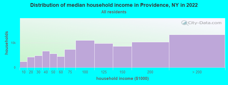
| Providence: | $81,481 |
| NY: | $79,557 |
Estimated per capita income in 2022: $41,089 (it was $18,853 in 2000)
Providence town income, earnings, and wages data
Estimated median house or condo value in 2022: $270,359 (it was $89,300 in 2000)
| Providence: | $270,359 |
| NY: | $400,400 |
Mean prices in 2022: all housing units: $364,924; detached houses: $380,932; townhouses or other attached units: $321,598; in 2-unit structures: $313,966; in 3-to-4-unit structures: $432,005; in 5-or-more-unit structures: over $1,000,000; mobile homes: $61,839
Detailed information about poverty and poor residents in Providence, NY


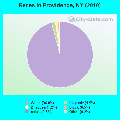
- 1,91596.0%White alone
- 381.9%Hispanic
- 241.2%Two or more races
- 100.5%Black alone
- 50.3%Asian alone
- 30.2%Other race alone
Races in Providence detailed stats: ancestries, foreign born residents, place of birth
 Recent articles from our blog. Our writers, many of them Ph.D. graduates or candidates, create easy-to-read articles on a wide variety of topics.
Ancestries: Irish (19.5%), German (18.6%), English (12.2%), Italian (8.1%), Polish (7.9%), French (7.3%).
Current Local Time: EST time zone
Land area: 44.0 square miles.
Population density: 45 people per square mile (very low).
35 residents are foreign born
| This town: | 1.9% |
| New York: | 20.4% |
| Providence town: | 1.8% ($1,585) |
| New York: | 1.9% ($2,847) |
Nearest city with pop. 50,000+: Schenectady, NY  (21.7 miles , pop. 61,821).
Nearest city with pop. 200,000+: Bronx, NY (156.4 miles , pop. 1,332,650).
Nearest cities:
), ), ), ), ), )Latitude: 43.10 N, Longitude: 74.05 W
Area code commonly used in this area: 518
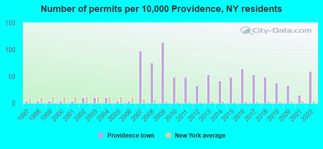
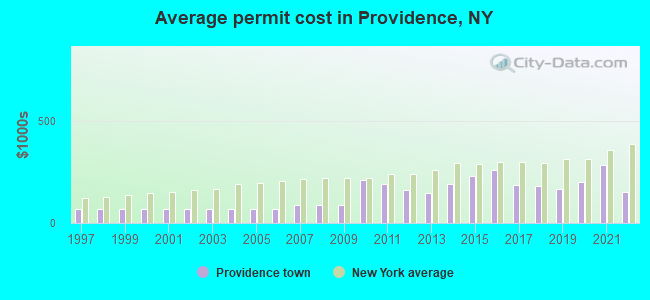
Single-family new house construction building permits:
- 2022: 11 buildings, average cost: $148,600
- 2021: 3 buildings, average cost: $284,000
- 2020: 6 buildings, average cost: $199,500
- 2019: 7 buildings, average cost: $168,100
- 2018: 9 buildings, average cost: $179,700
- 2017: 10 buildings, average cost: $186,700
- 2016: 12 buildings, average cost: $260,300
- 2015: 9 buildings, average cost: $228,900
- 2014: 8 buildings, average cost: $187,500
- 2013: 10 buildings, average cost: $145,000
- 2012: 6 buildings, average cost: $160,000
- 2011: 9 buildings, average cost: $191,900
- 2010: 9 buildings, average cost: $211,900
- 2009: 21 buildings, average cost: $90,000
- 2008: 14 buildings, average cost: $90,000
- 2007: 18 buildings, average cost: $90,000
- 2006: 1 building, cost: $70,000
- 2005: 1 building, cost: $70,000
- 2004: 2 buildings, average cost: $70,000
- 2003: 2 buildings, average cost: $70,000
- 2002: 2 buildings, average cost: $70,000
- 2001: 1 building, cost: $70,000
- 2000: 1 building, cost: $70,000
- 1999: 1 building, cost: $70,000
- 1998: 1 building, cost: $70,000
- 1997: 1 building, cost: $70,000
| Here: | 3.3% |
| New York: | 4.4% |
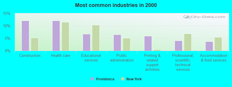
- Construction (12.1%)
- Health care (12.0%)
- Educational services (6.7%)
- Public administration (6.5%)
- Printing & related support activities (6.0%)
- Professional, scientific, technical services (4.0%)
- Accommodation & food services (3.7%)
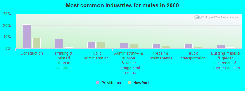
- Construction (20.9%)
- Printing & related support activities (8.5%)
- Public administration (5.3%)
- Administrative & support & waste management services (4.9%)
- Repair & maintenance (3.8%)
- Truck transportation (3.6%)
- Building material & garden equipment & supplies dealers (3.2%)
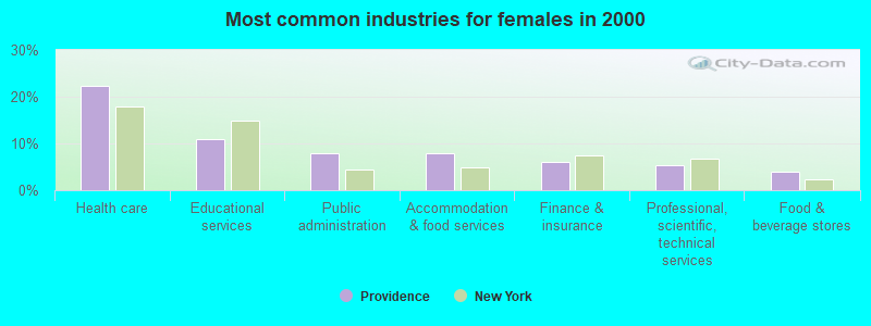
- Health care (22.4%)
- Educational services (11.0%)
- Public administration (7.9%)
- Accommodation & food services (7.9%)
- Finance & insurance (6.0%)
- Professional, scientific, technical services (5.3%)
- Food & beverage stores (4.1%)

- Other production occupations, including supervisors (6.9%)
- Other office and administrative support workers, including supervisors (4.8%)
- Driver/sales workers and truck drivers (4.4%)
- Building and grounds cleaning and maintenance occupations (3.9%)
- Health technologists and technicians (3.7%)
- Nursing, psychiatric, and home health aides (3.7%)
- Other sales and related occupations, including supervisors (3.4%)
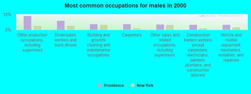
- Other production occupations, including supervisors (11.1%)
- Driver/sales workers and truck drivers (7.4%)
- Building and grounds cleaning and maintenance occupations (4.7%)
- Carpenters (4.7%)
- Other sales and related occupations, including supervisors (4.5%)
- Construction traders workers except carpenters, electricians, painters, plumbers, and construction laborers (4.3%)
- Vehicle and mobile equipment mechanics, installers, and repairers (4.3%)
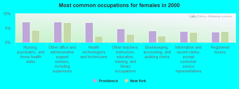
- Nursing, psychiatric, and home health aides (7.2%)
- Other office and administrative support workers, including supervisors (7.2%)
- Health technologists and technicians (6.9%)
- Other teachers, instructors, education, training, and library occupations (4.8%)
- Bookkeeping, accounting, and auditing clerks (4.1%)
- Information and record clerks, except customer service representatives (3.8%)
- Registered nurses (3.6%)
Average climate in Providence, New York
Based on data reported by over 4,000 weather stations


(lower is better)
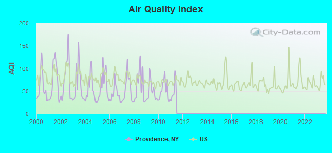
Air Quality Index (AQI) level in 2010 was 50.7. This is significantly better than average.
| City: | 50.7 |
| U.S.: | 72.6 |
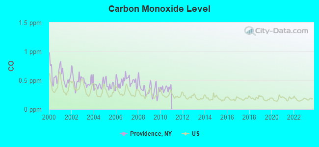
Carbon Monoxide (CO) [ppm] level in 2010 was 0.362. This is significantly worse than average. Closest monitor was 21.9 miles away from the city center.
| City: | 0.362 |
| U.S.: | 0.251 |
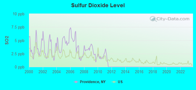
Sulfur Dioxide (SO2) [ppb] level in 2010 was 1.92. This is worse than average. Closest monitor was 15.1 miles away from the city center.
| City: | 1.92 |
| U.S.: | 1.51 |
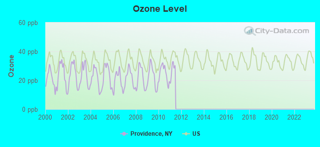
Ozone [ppb] level in 2010 was 24.8. This is better than average. Closest monitor was 21.9 miles away from the city center.
| City: | 24.8 |
| U.S.: | 33.3 |
Tornado activity:
Providence-area historical tornado activity is near New York state average. It is 64% smaller than the overall U.S. average.
On 7/10/1989, a category F4 (max. wind speeds 207-260 mph) tornado 30.7 miles away from the Providence town center injured 20 people and caused between $5,000,000 and $50,000,000 in damages.
On 6/16/1974, a category F3 (max. wind speeds 158-206 mph) tornado 15.4 miles away from the town center caused between $500,000 and $5,000,000 in damages.
Earthquake activity:
Providence-area historical earthquake activity is significantly above New York state average. It is 68% smaller than the overall U.S. average.On 10/7/1983 at 10:18:46, a magnitude 5.3 (5.1 MB, 5.3 LG, 5.1 ML, Class: Moderate, Intensity: VI - VII) earthquake occurred 60.5 miles away from Providence center
On 4/20/2002 at 10:50:47, a magnitude 5.3 (5.3 ML, Depth: 3.0 mi) earthquake occurred 99.0 miles away from Providence center
On 4/20/2002 at 10:50:47, a magnitude 5.2 (5.2 MB, 4.2 MS, 5.2 MW, 5.0 MW) earthquake occurred 97.1 miles away from Providence center
On 1/19/1982 at 00:14:42, a magnitude 4.7 (4.5 MB, 4.7 MD, 4.5 LG, Class: Light, Intensity: IV - V) earthquake occurred 126.4 miles away from Providence center
On 6/17/1991 at 08:53:16, a magnitude 4.1 (4.0 MB, 4.0 LG, Depth: 3.1 mi) earthquake occurred 45.6 miles away from the city center
On 10/16/2012 at 23:12:25, a magnitude 4.7 (4.7 ML, Depth: 10.0 mi) earthquake occurred 174.2 miles away from Providence center
Magnitude types: regional Lg-wave magnitude (LG), body-wave magnitude (MB), duration magnitude (MD), local magnitude (ML), surface-wave magnitude (MS), moment magnitude (MW)
Natural disasters:
The number of natural disasters in Saratoga County (17) is near the US average (15).Major Disasters (Presidential) Declared: 8
Emergencies Declared: 7
Causes of natural disasters: Winter Storms: 5, Storms: 4, Floods: 3, Hurricanes: 3, Snowstorms: 2, Blizzard: 1, Power Outage: 1, Tornado: 1, Wind: 1, Other: 2 (Note: some incidents may be assigned to more than one category).
Hospitals and medical centers near Providence:
- AIM SERVICES, INC (Hospital, about 11 miles away; BALLSTON SPA, NY)
- AIM SERVICES, INC (Hospital, about 12 miles away; SARATOGA SPRINGS, NY)
- AIM SERVICES, INC (Hospital, about 12 miles away; SARATOGA SPRINGS, NY)
- SARATOGA COUNTY MAPLEWOOD MANOR (Nursing Home, about 13 miles away; BALLSTON SPA, NY)
- AIM SERVICES, INC (Hospital, about 13 miles away; SARATOGA SPRINGS, NY)
- SARATOGA HOSPITAL Acute Care Hospitals (about 14 miles away; SARATOGA SPRINGS, NY)
- WESLEY HEALTH CARE CENTER (Nursing Home, about 14 miles away; SARATOGA SPRINGS, NY)
Amtrak stations near Providence:
- 13 miles: SARATOGA SPRINGS (WEST AVE. & STATION LN.) . Services: ticket office, partially wheelchair accessible, enclosed waiting area, public restrooms, public payphones, free short-term parking, free long-term parking, call for car rental service, call for taxi service, public transit connection.
- 14 miles: AMSTERDAM (RAILROAD & W. MAIN STS.) . Services: enclosed waiting area, public restrooms, public payphones, free short-term parking, free long-term parking, call for car rental service, call for taxi service, public transit connection.
Colleges/universities with over 2000 students nearest to Providence:
- Skidmore College (about 14 miles; Saratoga Springs, NY; Full-time enrollment: 2,753)
- SUNY Empire State College (about 14 miles; Saratoga Springs, NY; FT enrollment: 9,473)
- Fulton-Montgomery Community College (about 15 miles; Johnstown, NY; FT enrollment: 2,043)
- Schenectady County Community College (about 21 miles; Schenectady, NY; FT enrollment: 3,676)
- Union College (about 21 miles; Schenectady, NY; FT enrollment: 2,075)
- Adirondack Community College (about 27 miles; Queensbury, NY; FT enrollment: 2,826)
- Excelsior College (about 30 miles; Albany, NY; FT enrollment: 4,723)
Points of interest:
Notable locations in Providence: Circle T Farms (A), Skinner Corners (B), Wiley Corners (C), Long Corners (D). Display/hide their locations on the map
Church in Providence: Providence Baptist Church (A). Display/hide its location on the map
Cemeteries: Barkersville Cemetery (1), Hagadorn Cemetery (2). Display/hide their locations on the map
Lakes, reservoirs, and swamps: Ronna Pond (A), Round Lake (B), Shew Pond (C), Packers Pond (D), Cooks Reservoir (E), Steele Reservoir (F), Ireland Vly (G), Lake Nancy (H). Display/hide their locations on the map
Creeks: West Vly Creek (A), Fayville Creek (B), Evans Creek (C), Alder Creek (D), Black Creek (E), Cloutler Creek (F), Steele Creek (G), Cadman Creek (H), Joby Creek (I). Display/hide their locations on the map
| This town: | 2.6 people |
| New York: | 2.6 people |
| This town: | 72.1% |
| Whole state: | 63.5% |
| This town: | 9.7% |
| Whole state: | 6.8% |
Likely homosexual households (counted as self-reported same-sex unmarried-partner households)
- Lesbian couples: 0.5% of all households
- Gay men: 0.3% of all households
| This town: | 6.4% |
| Whole state: | 14.6% |
| This town: | 3.6% |
| Whole state: | 7.4% |
For population 15 years and over in Providence:
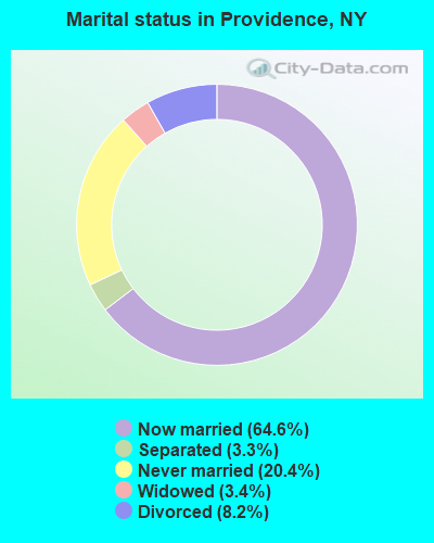
- Never married: 20.4%
- Now married: 64.6%
- Separated: 3.3%
- Widowed: 3.4%
- Divorced: 8.2%
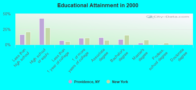
For population 25 years and over in Providence:
- High school or higher: 83.6%
- Bachelor's degree or higher: 12.0%
- Graduate or professional degree: 3.4%
- Unemployed: 4.2%
- Mean travel time to work (commute): 32.4 minutes
| Here: | 8.7 |
| New York average: | 14.2 |
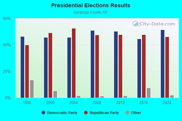
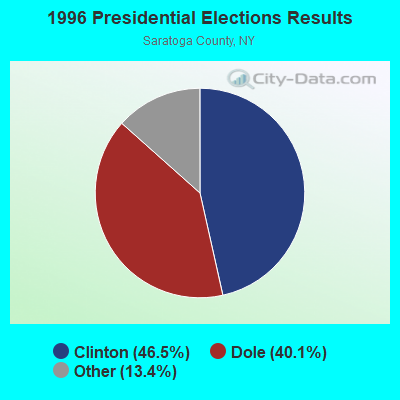
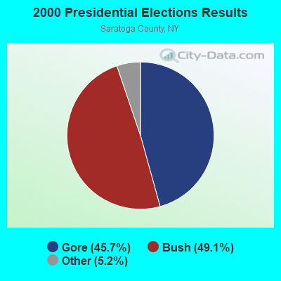
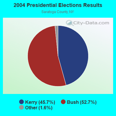
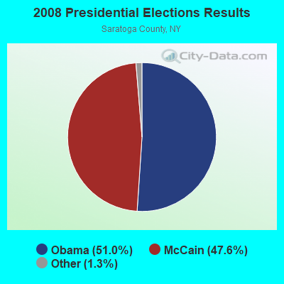
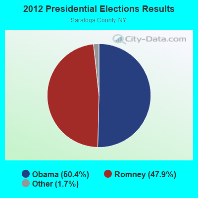
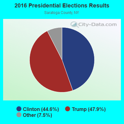
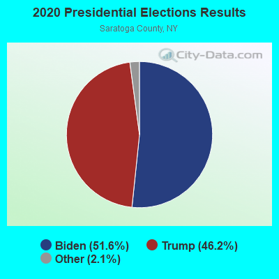
Graphs represent county-level data. Detailed 2008 Election Results
Religion statistics for Providence, NY (based on Saratoga County data)
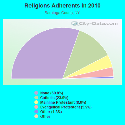
| Religion | Adherents | Congregations |
|---|---|---|
| Catholic | 52,507 | 16 |
| Mainline Protestant | 17,512 | 57 |
| Evangelical Protestant | 12,976 | 56 |
| Other | 2,828 | 14 |
| Orthodox | 210 | 2 |
| Black Protestant | 24 | 1 |
| None | 133,550 | - |
Food Environment Statistics:
| Saratoga County: | 1.44 / 10,000 pop. |
| New York: | 4.13 / 10,000 pop. |
| Saratoga County: | 0.14 / 10,000 pop. |
| New York: | 0.06 / 10,000 pop. |
| This county: | 0.37 / 10,000 pop. |
| New York: | 0.92 / 10,000 pop. |
| Saratoga County: | 3.99 / 10,000 pop. |
| New York: | 1.68 / 10,000 pop. |
| Here: | 9.04 / 10,000 pop. |
| New York: | 8.82 / 10,000 pop. |
| Here: | 7.5% |
| State: | 8.2% |
| Here: | 25.2% |
| New York: | 23.8% |
| Saratoga County: | 14.2% |
| State: | 15.6% |
Strongest AM radio stations in Providence:
- WGY (810 AM; 50 kW; SCHENECTADY, NY; Owner: CLEAR CHANNEL BROADCASTING LICENSES, INC.)
- WPTR (1540 AM; 50 kW; ALBANY, NY; Owner: KIMTRON, INC.)
- WABY (1160 AM; 5 kW; MECHANICVILLE, NY; Owner: ANASTOS MEDIA GROUP, INC.)
- WNNZ (640 AM; 50 kW; WESTFIELD, MA; Owner: CLEAR CHANNEL BROADCASTING LICENSES, INC.)
- WOFX (980 AM; 5 kW; TROY, NY)
- WROW (590 AM; 5 kW; ALBANY, NY; Owner: 6 JOHNSON ROAD LICENSES, INC.)
- WCSS (1490 AM; 1 kW; AMSTERDAM, NY; Owner: WEBER COMM. OF AMSTERDAM, INC.)
- WCRN (830 AM; 50 kW; WORCESTER, MA; Owner: CARTER BROADCASTING CORPORATION)
- WTIC (1080 AM; 50 kW; HARTFORD, CT; Owner: INFINITY RADIO OPERATIONS INC.)
- WIZR (930 AM; 1 kW; JOHNSTOWN, NY; Owner: 6 JOHNSON ROAD LICENSES, INC.)
- WRKO (680 AM; 50 kW; BOSTON, MA; Owner: ENTERCOM BOSTON LICENSE, LLC)
- WMCA (570 AM; 50 kW; NEW YORK, NY; Owner: SALEM MEDIA OF NEW YORK, LLC)
- WFAN (660 AM; 50 kW; NEW YORK, NY; Owner: INFINITY BROADCASTING OPERATIONS, INC.)
Strongest FM radio stations in Providence:
- WBKK (97.7 FM; AMSTERDAM, NY; Owner: GEM ASSOCIATES, L. P.)
- WFFG-FM (107.1 FM; CORINTH, NY; Owner: VOX NEW YORK, L.L.C.)
- WKBE (100.3 FM; WARRENSBURG, NY; Owner: 6 JOHNSON ROAD LICENSES, INC.)
- WKRD (93.7 FM; SCOTIA, NY; Owner: DOT COMMUNICATIONS, INC.)
- WCKM-FM (99.1 FM; LAKE GEORGE, NY; Owner: ENTERTRONICS, INC.)
- WNYQ (105.7 FM; QUEENSBURY, NY; Owner: VOX NEW YORK, L.L.C.)
- WCQL (95.9 FM; GLENS FALLS, NY; Owner: ENTERTRONICS, INC.)
- WBAR-FM (94.7 FM; LAKE LUZERNE, NY; Owner: CAPITAL MEDIA CORPORATION)
- WXLG (89.9 FM; NORTH CREEK, NY; Owner: THE ST. LAWRENCE UNIVERSITY)
- WEQX (102.7 FM; MANCHESTER, VT; Owner: NORTHSHIRE COMMUNICATIONS, INC.)
- WPGL (90.7 FM; PATTERSONVILLE, NY; Owner: SOUND OF LIFE, INC.)
- WJAN (95.1 FM; SUNDERLAND, VT; Owner: 6 JOHNSON ROAD LICENSES, INC.)
- WNGN (91.9 FM; ARGYLE, NY; Owner: NORTHEAST GOSPEL BROADCASTING INC)
- WSSK (89.7 FM; SARATOGA SPRINGS, NY; Owner: SOUND OF LIFE, INC.)
- WAJZ (96.3 FM; VOORHEESVILLE, NY; Owner: 6 JOHNSON ROAD LICENSES, INC.)
- WYJB (95.5 FM; ALBANY, NY; Owner: 6 JOHNSON ROAD LICENSES, INC.)
- WZMR (104.9 FM; ALTAMONT, NY; Owner: 6 JOHNSON ROAD LICENSES, INC.)
- WGNA-FM (107.7 FM; ALBANY, NY; Owner: REGENT LICENSEE OF MANSFIELD, INC.)
- WAMC-FM (90.3 FM; ALBANY, NY; Owner: WAMC)
- WZEC (97.5 FM; HOOSICK FALLS, NY; Owner: GREAT NORTHERN RADIO, LLC)
TV broadcast stations around Providence:
- WYPX (Channel 55; AMSTERDAM, NY; Owner: PAXSON ALBANY LICENSE, INC.)
- WFNY-CA (Channel 49; GLOVERSVILLE, NY; Owner: MICHAEL A. SLEEZER)
- National Bridge Inventory (NBI) Statistics
- 14Number of bridges
- 52ft / 15.9mTotal length
- $7,403,000Total costs
- 5,784Total average daily traffic
- 324Total average daily truck traffic
- 7,525Total future (year 2037) average daily traffic
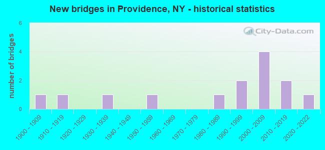
- New bridges - historical statistics
- 11900-1909
- 11910-1919
- 11930-1939
- 11950-1959
- 11980-1989
- 21990-1999
- 42000-2009
- 22010-2019
- 12020-2022
FCC Registered Private Land Mobile Towers:
1- Wiley Town & Antioch Rd (Lat: 43.110361 Lon: -74.008750), Structure height: 61 m, Call Sign: WNZM302, Licensee ID: L00348838,
Assigned Frequencies: 861.962 MHz, 862.962 MHz, 863.962 MHz, 864.962 MHz, 865.962 MHz, Grant Date: 05/22/1997, Expiration Date: 05/22/2007, Cancellation Date: 09/19/2001, Registrant: Ronald Legros, 137 Town Office Rd, Troy, NY 12180, Phone: (617) 343-7687
FCC Registered Broadcast Land Mobile Towers:
2- Cr 16 (Lat: 43.100917 Lon: -74.036528), Call Sign: WNDR783,
Assigned Frequencies: 46.4200 MHz, Grant Date: 06/06/2015, Expiration Date: 08/28/2025, Registrant: Saratoga County Office Of Emergency Services, 25 West High Street, Ballston Spa, NY 12020, Phone: (518) 885-2232, Email:
- Fish House Rd Rd 1 Middle Grove (Lat: 43.080361 Lon: -74.102639), Call Sign: KBK208, Licensee ID: L00005651,
Assigned Frequencies: 155.925 MHz, Grant Date: 08/16/2001, Expiration Date: 09/29/2011, Cancellation Date: 09/13/2011, Registrant: County Of Saratoga, County Complex, Ballston Spa, NY 12020, Phone: (518) 885-2232
FCC Registered Microwave Towers:
2- STATION, Barkersville Rd (Lat: 43.101167 Lon: -74.035944), Overall height: 54.9 m, Call Sign: WNEW677, Licensee ID: L00005651,
Assigned Frequencies: 2183.20 MHz, Grant Date: 12/23/1998, Expiration Date: 04/05/2009, Cancellation Date: 06/06/2009, Registrant: County Of Saratoga
- Wiley Town & Antioch Rds (Lat: 43.110333 Lon: -74.008722), Overall height: 57.9 m, Call Sign: WPJB741,
Assigned Frequencies: 942.975 MHz, Grant Date: 12/14/1995, Expiration Date: 12/14/2000, Cancellation Date: 03/18/2001, Phone: (518) 458-6090
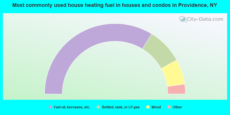
- 67.4%Fuel oil, kerosene, etc.
- 16.6%Bottled, tank, or LP gas
- 11.5%Wood
- 3.5%Electricity
- 0.3%Utility gas
- 0.3%Coal or coke
- 0.3%Other fuel
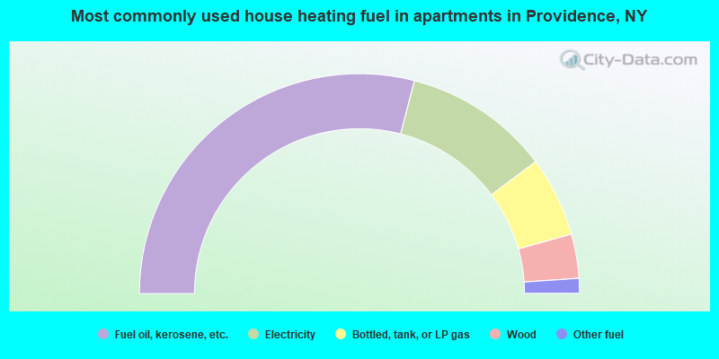
- 58.1%Fuel oil, kerosene, etc.
- 21.5%Electricity
- 11.8%Bottled, tank, or LP gas
- 6.5%Wood
- 2.2%Other fuel
Providence compared to New York state average:
- Unemployed percentage significantly below state average.
- Black race population percentage significantly below state average.
- Hispanic race population percentage significantly below state average.
- Foreign-born population percentage significantly below state average.
- Renting percentage significantly below state average.
- Length of stay since moving in significantly above state average.
- Number of rooms per house significantly below state average.
- House age significantly below state average.
- Percentage of population with a bachelor's degree or higher significantly below state average.