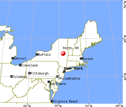
Perth, New York
Submit your own pictures of this town and show them to the world
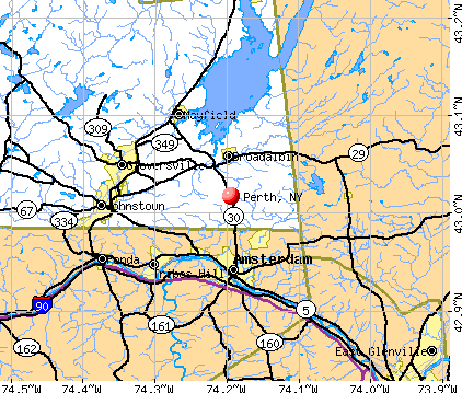
- OSM Map
- General Map
- Google Map
- MSN Map
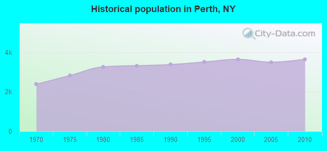
Population change since 2000: +0.2%
 |
| Males: 1,807 | |
| Females: 1,839 |
| Median resident age: | 43.2 years |
| New York median age: | 40.7 years |
Zip codes: 12010.
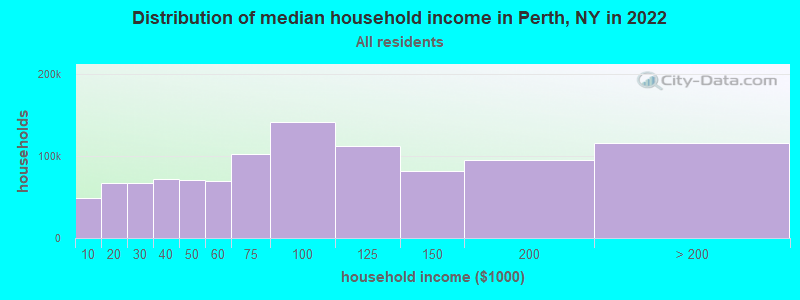
| Perth: | $70,220 |
| NY: | $79,557 |
Estimated per capita income in 2022: $33,509 (it was $16,870 in 2000)
Perth town income, earnings, and wages data
Estimated median house or condo value in 2022: $185,501 (it was $79,200 in 2000)
| Perth: | $185,501 |
| NY: | $400,400 |
Mean prices in 2022: all housing units: $210,218; detached houses: $204,827; townhouses or other attached units: $209,530; in 2-unit structures: $308,153; in 3-to-4-unit structures: $162,839; mobile homes: $108,528
Detailed information about poverty and poor residents in Perth, NY
Compare current foreclosures near Perth, NY:
| Photo | Address | Area | Beds / Baths | Price | Details |
|---|---|---|---|---|---|

|
#1
Lansing Rd
Fultonville, NY 12072
|
1,248 sq. feet
|
2 baths 3 beds |
$204,500
|
show details |

|
#2
Mill Street
Broadalbin, NY 12025
|
1,400 sq. feet
|
1 baths 3 beds |
$69,900
|
show details |

|
#3
Lincoln St
Gloversville, NY 12078
|
2,600 sq. feet
|
3 baths 6 beds |
$29,900
|
show details |

|
#4
Prospect Ave
Gloversville, NY 12078
|
2,078 sq. feet
|
2 baths 2 beds |
show details | |

|
#5
Mckinley Pl
Gloversville, NY 12078
|
1,120 sq. feet
|
1 baths 1 beds |
show details | |

|
#6
Sacandaga Rd
Schenectady, NY 12302
|
1,272 sq. feet
|
1 baths 3 beds |
show details | |

|
#7
State Highway 30
Gloversville, NY 12078
|
1,242 sq. feet
|
1 baths 2 beds |
show details | |

|
#8
Temple St
Gloversville, NY 12078
|
1,824 sq. feet
|
1 baths 3 beds |
show details | |

|
#9
Drager Rd
Galway, NY 12074
|
1,560 sq. feet
|
2 baths 3 beds |
show details | |

|
#10
Heagle Rd
Johnstown, NY 12095
|
1,710 sq. feet
|
1 baths 3 beds |
show details |
| Photo | Address | Area | Beds / Baths | Price | Details |
|---|---|---|---|---|---|

|
#11
Western Ave
Amsterdam, NY 12010
|
1,564 sq. feet
|
1 baths 2 beds |
show details | |

|
#12
State Hwy 349
Gloversville, NY 12078
|
1,287 sq. feet
|
1 baths 3 beds |
show details | |

|
#13
Valleyview Dr
Fultonville, NY 12072
|
1,618 sq. feet
|
2 baths 3 beds |
show details | |

|
#14
Maple Ave
Ballston Spa, NY 12020
|
1,332 sq. feet
|
2 baths 3 beds |
show details | |

|
#15
Lexington Ave # 2
Gloversville, NY 12078
|
3,096 sq. feet
|
2 baths 5 beds |
show details | |

|
#16
Orchard St
Gloversville, NY 12078
|
1,702 sq. feet
|
1 baths 3 beds |
show details | |

|
#17
S Toll St
Schenectady, NY 12302
|
1,152 sq. feet
|
1 baths 3 beds |
show details | |

|
#18
E Main St
Johnstown, NY 12095
|
1,500 sq. feet
|
1 baths 3 beds |
show details | |

|
#19
State Highway 161
Amsterdam, NY 12010
|
2,240 sq. feet
|
2 baths 3 beds |
show details | |

|
#20
S Perry St
Johnstown, NY 12095
|
2,184 sq. feet
|
1 baths 4 beds |
show details |
| Photo | Address | Area | Beds / Baths | Price | Details |
|---|---|---|---|---|---|

|
#21
James St
Gloversville, NY 12078
|
1,500 sq. feet
|
1 baths 2 beds |
show details | |

|
#22
Maple Ave
Gloversville, NY 12078
|
2,079 sq. feet
|
2 baths 4 beds |
show details | |

|
#23
Bancker Ave
Schenectady, NY 12302
|
2,004 sq. feet
|
2 baths 4 beds |
show details | |

|
#24
Spring St
Gloversville, NY 12078
|
2,376 sq. feet
|
2 baths 6 beds |
show details | |

|
#25
Easterly St
Gloversville, NY 12078
|
1,672 sq. feet
|
2 baths 3 beds |
show details | |

|
#26
Easterly St
Gloversville, NY 12078
|
1,260 sq. feet
|
1 baths 2 beds |
show details | |

|
#27
Gordon Rd
Schenectady, NY 12306
|
1,100 sq. feet
|
1 baths 2 beds |
show details | |

|
#28
Washington St
Johnstown, NY 12095
|
2,400 sq. feet
|
2 baths 4 beds |
show details | |

|
#29
County Highway 102
Gloversville, NY 12078
|
1,240 sq. feet
|
1 baths 2 beds |
show details | |

|
#30
Cedar Ln
Schenectady, NY 12302
|
2,550 sq. feet
|
2 baths 4 beds |
show details |
| Photo | Address | Area | Beds / Baths | Price | Details |
|---|---|---|---|---|---|

|
#31
Beech St
Gloversville, NY 12078
|
904 sq. feet
|
1 baths 2 beds |
show details | |

|
#32
6th St
Schenectady, NY 12302
|
1,689 sq. feet
|
1 baths 4 beds |
show details | |

|
#33
Bloomingdale Ave
Gloversville, NY 12078
|
1,189 sq. feet
|
2 baths 3 beds |
show details | |

|
#34
Root Ave
Schenectady, NY 12302
|
964 sq. feet
|
1 baths 3 beds |
show details | |

|
#35
Crestline Dr
Ballston Spa, NY 12020
|
957 sq. feet
|
1 baths 3 beds |
show details | |

|
#36
S Judson St
Gloversville, NY 12078
|
1,458 sq. feet
|
1 baths 3 beds |
show details | |

|
#37
Mudge Rd
Delanson, NY 12053
|
2,086 sq. feet
|
2 baths 3 beds |
show details | |

|
#38
6th Ave
Gloversville, NY 12078
|
1,606 sq. feet
|
1 baths 4 beds |
show details | |

|
#39
Meadow Ln
Ballston Spa, NY 12020
|
957 sq. feet
|
1 baths 3 beds |
show details | |

|
#40
Argersinger Rd
Fultonville, NY 12072
|
1,247 sq. feet
|
1 baths 3 beds |
show details |
| Photo | Address | Area | Beds / Baths | Price | Details |
|---|---|---|---|---|---|

|
#41
S Market St
Johnstown, NY 12095
|
1,360 sq. feet
|
2 baths 2 beds |
show details | |

|
#42
W Madison Ave
Johnstown, NY 12095
|
1,232 sq. feet
|
1 baths 3 beds |
show details | |

|
#43
W Fulton St
Johnstown, NY 12095
|
1,764 sq. feet
|
2 baths 4 beds |
show details | |

|
#44
Park Ave
Middle Grove, NY 12850
|
1,156 sq. feet
|
1 baths 4 beds |
show details | |

|
#45
Evergreen Blvd
Schenectady, NY 12302
|
1,516 sq. feet
|
1 baths 3 beds |
show details | |

|
#46
Vley Rd
Schenectady, NY 12302
|
1,381 sq. feet
|
1 baths 3 beds |
show details | |

|
#47
Mudge Rd
Delanson, NY 12053
|
2,399 sq. feet
|
2 baths 4 beds |
show details | |

|
#48
Upper Gregg Rd
Schenectady, NY 12306
|
976 sq. feet
|
1 baths 2 beds |
show details | |

|
#49
De Graff Ln
Ballston Lake, NY 12019
|
932 sq. feet
|
1 baths 3 beds |
show details | |

|
Check over 1 million property listings on Foreclosure.com!
|
browse all offers | |||

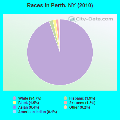
- 3,45194.7%White alone
- 681.9%Hispanic
- 541.5%Black alone
- 471.3%Two or more races
- 140.4%Asian alone
- 60.2%Other race alone
- 50.1%American Indian alone
- 10.03%Native Hawaiian and Other
Pacific Islander alone
Races in Perth detailed stats: ancestries, foreign born residents, place of birth
 Recent articles from our blog. Our writers, many of them Ph.D. graduates or candidates, create easy-to-read articles on a wide variety of topics.


Latest news from Perth, NY collected exclusively by city-data.com from local newspapers, TV, and radio stations
Ancestries: Italian (19.7%), Polish (17.0%), German (15.8%), Irish (14.2%), English (10.0%), French (6.5%).
Current Local Time: EST time zone
Land area: 26.1 square miles.
Population density: 140 people per square mile (very low).
53 residents are foreign born
| This town: | 1.5% |
| New York: | 20.4% |
| Perth town: | 2.7% ($2,112) |
| New York: | 1.9% ($2,847) |
Nearest city with pop. 50,000+: Schenectady, NY  (18.8 miles , pop. 61,821).
Nearest city with pop. 200,000+: Bronx, NY (150.1 miles , pop. 1,332,650).
Nearest cities:
), ), ), ), Latitude: 43.01 N, Longitude: 74.18 W
Area code commonly used in this area: 518

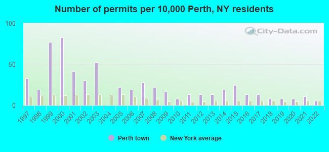
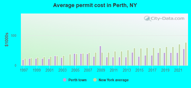
Single-family new house construction building permits:
- 2022: 2 buildings, average cost: $279,200
- 2021: 4 buildings, average cost: $216,700
- 2020: 3 buildings, average cost: $216,700
- 2019: 3 buildings, average cost: $216,700
- 2018: 3 buildings, average cost: $216,700
- 2017: 5 buildings, average cost: $173,100
- 2016: 5 buildings, average cost: $173,100
- 2015: 9 buildings, average cost: $152,800
- 2014: 7 buildings, average cost: $221,700
- 2013: 5 buildings, average cost: $142,200
- 2012: 5 buildings, average cost: $142,200
- 2011: 5 buildings, average cost: $142,200
- 2010: 3 buildings, average cost: $140,800
- 2009: 6 buildings, average cost: $327,900
- 2008: 8 buildings, average cost: $151,600
- 2007: 10 buildings, average cost: $196,200
- 2006: 7 buildings, average cost: $199,500
- 2005: 8 buildings, average cost: $199,500
- 2003: 19 buildings, average cost: $134,200
- 2002: 11 buildings, average cost: $159,900
- 2001: 15 buildings, average cost: $113,100
- 2000: 30 buildings, average cost: $117,700
- 1999: 28 buildings, average cost: $117,700
- 1998: 7 buildings, average cost: $118,300
- 1997: 12 buildings, average cost: $99,200
| Here: | 5.0% |
| New York: | 4.4% |
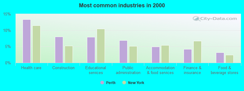
- Health care (13.4%)
- Construction (8.0%)
- Educational services (8.0%)
- Public administration (6.9%)
- Accommodation & food services (4.9%)
- Finance & insurance (4.2%)
- Food & beverage stores (3.2%)
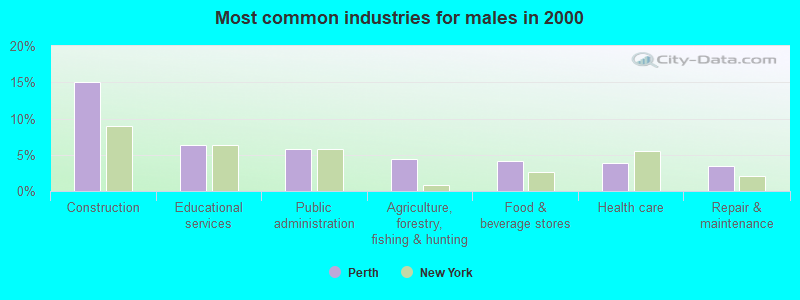
- Construction (15.1%)
- Educational services (6.3%)
- Public administration (5.8%)
- Agriculture, forestry, fishing & hunting (4.4%)
- Food & beverage stores (4.2%)
- Health care (3.8%)
- Repair & maintenance (3.4%)
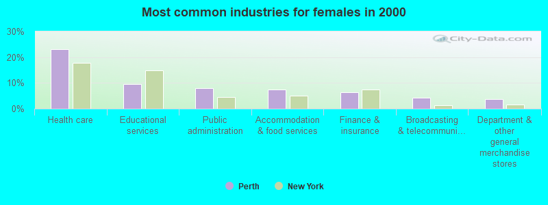
- Health care (23.2%)
- Educational services (9.6%)
- Public administration (8.1%)
- Accommodation & food services (7.6%)
- Finance & insurance (6.4%)
- Broadcasting & telecommunications (4.2%)
- Department & other general merchandise stores (3.7%)
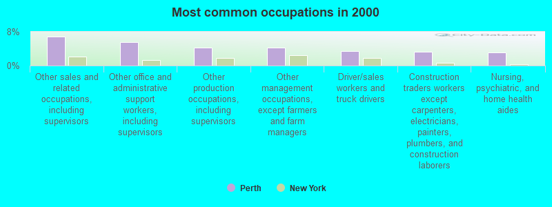
- Other sales and related occupations, including supervisors (6.9%)
- Other office and administrative support workers, including supervisors (5.6%)
- Other production occupations, including supervisors (4.2%)
- Other management occupations, except farmers and farm managers (4.2%)
- Driver/sales workers and truck drivers (3.4%)
- Construction traders workers except carpenters, electricians, painters, plumbers, and construction laborers (3.2%)
- Nursing, psychiatric, and home health aides (3.1%)
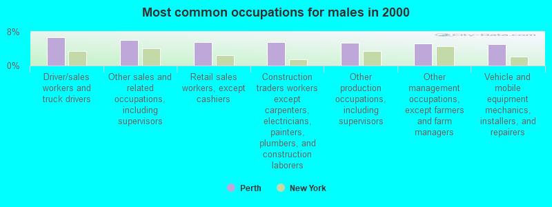
- Driver/sales workers and truck drivers (6.7%)
- Other sales and related occupations, including supervisors (6.1%)
- Retail sales workers, except cashiers (5.6%)
- Construction traders workers except carpenters, electricians, painters, plumbers, and construction laborers (5.6%)
- Other production occupations, including supervisors (5.4%)
- Other management occupations, except farmers and farm managers (5.2%)
- Vehicle and mobile equipment mechanics, installers, and repairers (5.1%)
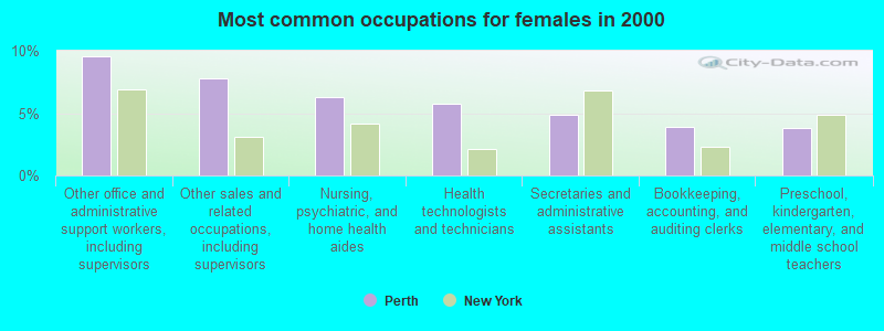
- Other office and administrative support workers, including supervisors (9.5%)
- Other sales and related occupations, including supervisors (7.8%)
- Nursing, psychiatric, and home health aides (6.3%)
- Health technologists and technicians (5.7%)
- Secretaries and administrative assistants (4.8%)
- Bookkeeping, accounting, and auditing clerks (3.9%)
- Preschool, kindergarten, elementary, and middle school teachers (3.8%)
Average climate in Perth, New York
Based on data reported by over 4,000 weather stations


(lower is better)
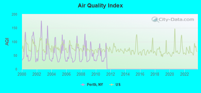
Air Quality Index (AQI) level in 2010 was 50.7. This is significantly better than average.
| City: | 50.7 |
| U.S.: | 72.6 |
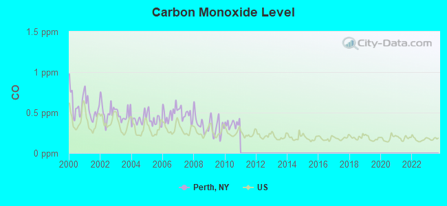
Carbon Monoxide (CO) [ppm] level in 2010 was 0.362. This is significantly worse than average. Closest monitor was 18.8 miles away from the city center.
| City: | 0.362 |
| U.S.: | 0.251 |
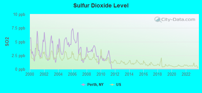
Sulfur Dioxide (SO2) [ppb] level in 2010 was 1.92. This is worse than average. Closest monitor was 8.9 miles away from the city center.
| City: | 1.92 |
| U.S.: | 1.51 |
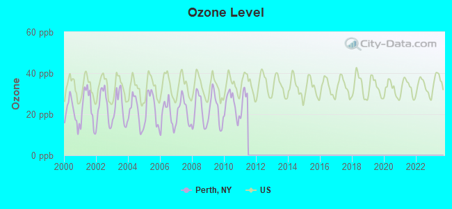
Ozone [ppb] level in 2010 was 24.8. This is better than average. Closest monitor was 18.8 miles away from the city center.
| City: | 24.8 |
| U.S.: | 33.3 |
Tornado activity:
Perth-area historical tornado activity is near New York state average. It is 63% smaller than the overall U.S. average.
On 7/10/1989, a category F4 (max. wind speeds 207-260 mph) tornado 21.5 miles away from the Perth town center injured 20 people and caused between $5,000,000 and $50,000,000 in damages.
On 6/16/1974, a category F3 (max. wind speeds 158-206 mph) tornado 16.3 miles away from the town center caused between $500,000 and $5,000,000 in damages.
Earthquake activity:
Perth-area historical earthquake activity is significantly above New York state average. It is 68% smaller than the overall U.S. average.On 10/7/1983 at 10:18:46, a magnitude 5.3 (5.1 MB, 5.3 LG, 5.1 ML, Class: Moderate, Intensity: VI - VII) earthquake occurred 66.1 miles away from the city center
On 4/20/2002 at 10:50:47, a magnitude 5.3 (5.3 ML, Depth: 3.0 mi) earthquake occurred 107.0 miles away from Perth center
On 4/20/2002 at 10:50:47, a magnitude 5.2 (5.2 MB, 4.2 MS, 5.2 MW, 5.0 MW) earthquake occurred 105.0 miles away from the city center
On 1/19/1982 at 00:14:42, a magnitude 4.7 (4.5 MB, 4.7 MD, 4.5 LG, Class: Light, Intensity: IV - V) earthquake occurred 134.4 miles away from Perth center
On 6/17/1991 at 08:53:16, a magnitude 4.1 (4.0 MB, 4.0 LG, Depth: 3.1 mi) earthquake occurred 36.2 miles away from Perth center
On 10/16/2012 at 23:12:25, a magnitude 4.7 (4.7 ML, Depth: 10.0 mi) earthquake occurred 182.0 miles away from Perth center
Magnitude types: regional Lg-wave magnitude (LG), body-wave magnitude (MB), duration magnitude (MD), local magnitude (ML), surface-wave magnitude (MS), moment magnitude (MW)
Natural disasters:
The number of natural disasters in Fulton County (15) is near the US average (15).Major Disasters (Presidential) Declared: 7
Emergencies Declared: 6
Causes of natural disasters: Storms: 5, Floods: 4, Hurricanes: 3, Snowstorms: 2, Blizzard: 1, Power Outage: 1, Tornado: 1, Tropical Storm: 1, Wind: 1, Winter Storm: 1, Other: 2 (Note: some incidents may be assigned to more than one category).
Hospitals and medical centers near Perth:
- ST MARY'S HOSPITAL AT AMSTERDAM Acute Care Hospitals (about 5 miles away; AMSTERDAM, NY)
- RIVER RIDGE LIVING CENTER L L C (Nursing Home, about 5 miles away; AMSTERDAM, NY)
- MT LORETTO NURSING HOME INC (Nursing Home, about 8 miles away; AMSTERDAM, NY)
- MOUNTAIN VALLEY HOSPICE (Hospital, about 9 miles away; GLOVERSVILLE, NY)
- NATHAN LITTAUER HOSPITAL Acute Care Hospitals (about 9 miles away; GLOVERSVILLE, NY)
- WELLS NURSING HOME INC (Nursing Home, about 10 miles away; JOHNSTOWN, NY)
- JOHNSTOWN HOSPITAL (Hospital, about 11 miles away; JOHNSTOWN, NY)
Airports located in Perth:
- Hart Airport (9NY7) (Runways: 1)
- Johnson Airport (NY50) (Runways: 1)
- Murphys Lndg Strip Airport (0NY7) (Runways: 1)
- Wenskoski Field Airport (0NY8) (Runways: 1)
Amtrak stations near Perth:
- 5 miles: AMSTERDAM (RAILROAD & W. MAIN STS.) . Services: enclosed waiting area, public restrooms, public payphones, free short-term parking, free long-term parking, call for car rental service, call for taxi service, public transit connection.
- 18 miles: SCHENECTADY (332 ERIE BLVD.) . Services: ticket office, fully wheelchair accessible, enclosed waiting area, public restrooms, public payphones, vending machines, ATM, free short-term parking, free long-term parking, call for car rental service, taxi stand, public transit connection.
- 20 miles: SARATOGA SPRINGS (WEST AVE. & STATION LN.) . Services: ticket office, partially wheelchair accessible, enclosed waiting area, public restrooms, public payphones, free short-term parking, free long-term parking, call for car rental service, call for taxi service, public transit connection.
Colleges/universities with over 2000 students nearest to Perth:
- Fulton-Montgomery Community College (about 6 miles; Johnstown, NY; Full-time enrollment: 2,043)
- Schenectady County Community College (about 18 miles; Schenectady, NY; FT enrollment: 3,676)
- Union College (about 19 miles; Schenectady, NY; FT enrollment: 2,075)
- SUNY Empire State College (about 21 miles; Saratoga Springs, NY; FT enrollment: 9,473)
- Skidmore College (about 21 miles; Saratoga Springs, NY; FT enrollment: 2,753)
- Excelsior College (about 27 miles; Albany, NY; FT enrollment: 4,723)
- SUNY at Albany (about 29 miles; Albany, NY; FT enrollment: 15,490)
Points of interest:
Notable locations in Perth: Goderies Tree Farm (A), Windy Willow Farm (B), Tryon Secure Center for Girls (C), Chrissy's Greenhouses (D), Perth Volunteer Fire Company (E). Display/hide their locations on the map
Church in Perth: Bible Truth Hall (A). Display/hide its location on the map
Cemeteries: Perth Cemetery (1), West Galway Cemetery (2). Display/hide their locations on the map
Streams, rivers, and creeks: Healy Kill (A). Display/hide its location on the map
Birthplace of: John Knox Stewart - Politician, Robert P. Aitken - Politician in Michigan.
Drinking water stations with addresses in Perth and their reported violations in the past:
PERTHSHIRE CATERING (Population served: 101, Groundwater):Past health violations:Past monitoring violations:
- MCL, Monthly (TCR) - In JUL-2011, Contaminant: Coliform. Follow-up actions: St Compliance achieved (AUG-22-2011), St Public Notif requested (SEP-14-2011), St Formal NOV issued (SEP-14-2011)
- MCL, Monthly (TCR) - In JUN-2011, Contaminant: Coliform. Follow-up actions: St Public Notif requested (AUG-03-2011), St Formal NOV issued (AUG-03-2011), St Compliance achieved (AUG-22-2011)
- 9 routine major monitoring violations
| This town: | 2.5 people |
| New York: | 2.6 people |
| This town: | 69.5% |
| Whole state: | 63.5% |
| This town: | 8.5% |
| Whole state: | 6.8% |
Likely homosexual households (counted as self-reported same-sex unmarried-partner households)
- Lesbian couples: 0.4% of all households
- Gay men: 0.1% of all households
| This town: | 6.1% |
| Whole state: | 14.6% |
| This town: | 2.6% |
| Whole state: | 7.4% |
362 people in training schools for juvenile delinquents in 2000
For population 15 years and over in Perth:
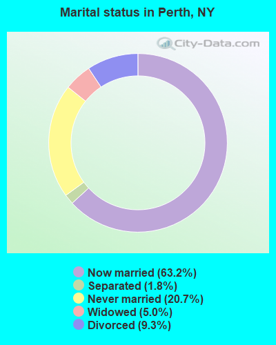
- Never married: 20.7%
- Now married: 63.2%
- Separated: 1.8%
- Widowed: 5.0%
- Divorced: 9.3%
For population 25 years and over in Perth:
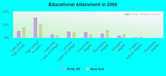
- High school or higher: 86.5%
- Bachelor's degree or higher: 15.4%
- Graduate or professional degree: 6.6%
- Unemployed: 4.4%
- Mean travel time to work (commute): 25.2 minutes
| Here: | 9.4 |
| New York average: | 14.2 |
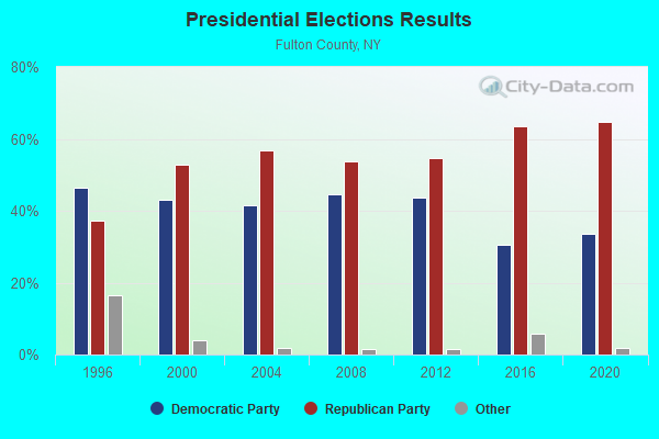
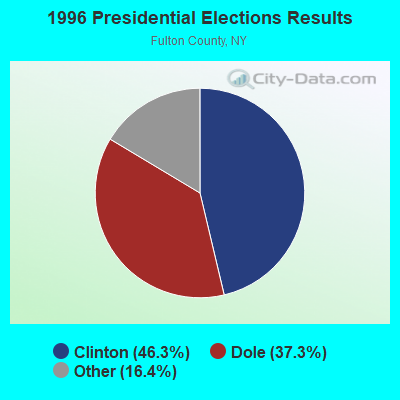
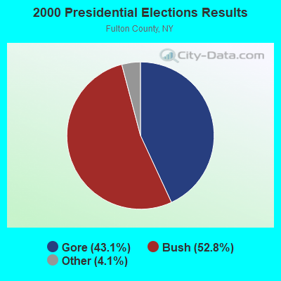

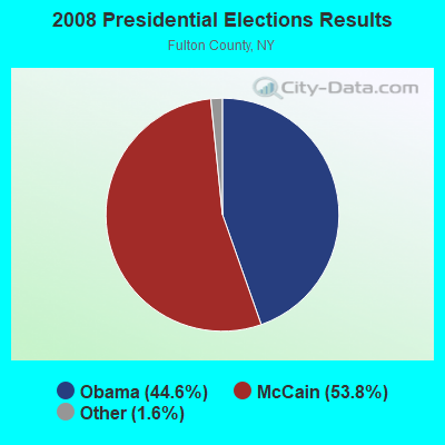
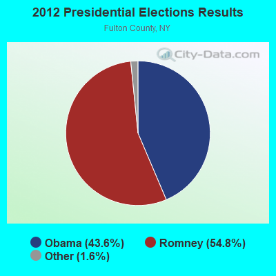
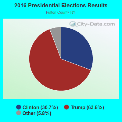
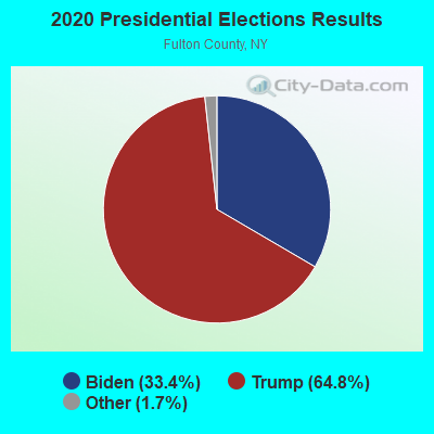
Graphs represent county-level data. Detailed 2008 Election Results
Religion statistics for Perth, NY (based on Fulton County data)
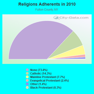
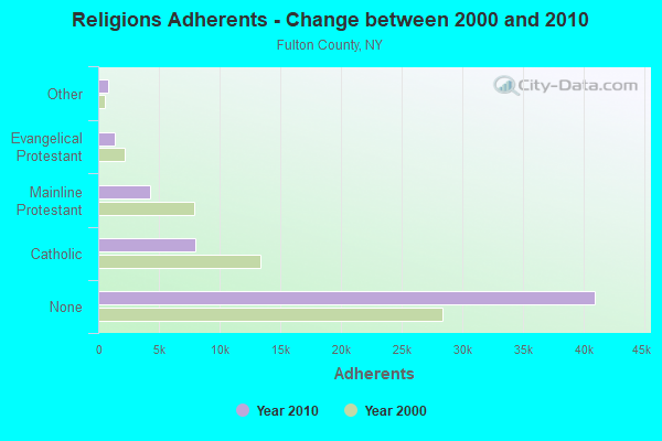
| Religion | Adherents | Congregations |
|---|---|---|
| Catholic | 7,963 | 4 |
| Mainline Protestant | 4,264 | 22 |
| Evangelical Protestant | 1,351 | 20 |
| Other | 793 | 4 |
| Black Protestant | 156 | 2 |
| Orthodox | 30 | 1 |
| None | 40,974 | - |
Food Environment Statistics:
| Fulton County: | 1.82 / 10,000 pop. |
| New York: | 4.13 / 10,000 pop. |
| This county: | 1.09 / 10,000 pop. |
| New York: | 0.92 / 10,000 pop. |
| Fulton County: | 3.28 / 10,000 pop. |
| New York: | 1.68 / 10,000 pop. |
| Fulton County: | 8.92 / 10,000 pop. |
| State: | 8.82 / 10,000 pop. |
| Fulton County: | 8.0% |
| New York: | 8.2% |
| This county: | 25.7% |
| New York: | 23.8% |
| This county: | 14.6% |
| New York: | 15.6% |
Strongest AM radio stations in Perth:
- WGY (810 AM; 50 kW; SCHENECTADY, NY; Owner: CLEAR CHANNEL BROADCASTING LICENSES, INC.)
- WCSS (1490 AM; 1 kW; AMSTERDAM, NY; Owner: WEBER COMM. OF AMSTERDAM, INC.)
- WPTR (1540 AM; 50 kW; ALBANY, NY; Owner: KIMTRON, INC.)
- WBUG (1570 AM; 1 kW; AMSTERDAM, NY; Owner: ROSER COMMUNICATIONS NETWORK, INC.)
- WIZR (930 AM; 1 kW; JOHNSTOWN, NY; Owner: 6 JOHNSON ROAD LICENSES, INC.)
- WENT (1340 AM; 1 kW; GLOVERSVILLE, NY; Owner: WHITNEY RADIO BROADCASTING, INC.)
- WOFX (980 AM; 5 kW; TROY, NY)
- WNNZ (640 AM; 50 kW; WESTFIELD, MA; Owner: CLEAR CHANNEL BROADCASTING LICENSES, INC.)
- WFNY (1440 AM; 1 kW; GLOVERSVILLE, NY; Owner: MICHAEL A. SLEEZER)
- WABY (1160 AM; 5 kW; MECHANICVILLE, NY; Owner: ANASTOS MEDIA GROUP, INC.)
- WROW (590 AM; 5 kW; ALBANY, NY; Owner: 6 JOHNSON ROAD LICENSES, INC.)
- WTIC (1080 AM; 50 kW; HARTFORD, CT; Owner: INFINITY RADIO OPERATIONS INC.)
- WCRN (830 AM; 50 kW; WORCESTER, MA; Owner: CARTER BROADCASTING CORPORATION)
Strongest FM radio stations in Perth:
- WBKK (97.7 FM; AMSTERDAM, NY; Owner: GEM ASSOCIATES, L. P.)
- WPGL (90.7 FM; PATTERSONVILLE, NY; Owner: SOUND OF LIFE, INC.)
- WAJZ (96.3 FM; VOORHEESVILLE, NY; Owner: 6 JOHNSON ROAD LICENSES, INC.)
- WYJB (95.5 FM; ALBANY, NY; Owner: 6 JOHNSON ROAD LICENSES, INC.)
- WQBJ (103.5 FM; COBLESKILL, NY; Owner: REGENT LICENSEE OF MANSFIELD, INC.)
- WZMR (104.9 FM; ALTAMONT, NY; Owner: 6 JOHNSON ROAD LICENSES, INC.)
- WGNA-FM (107.7 FM; ALBANY, NY; Owner: REGENT LICENSEE OF MANSFIELD, INC.)
- WEQX (102.7 FM; MANCHESTER, VT; Owner: NORTHSHIRE COMMUNICATIONS, INC.)
- WXLG (89.9 FM; NORTH CREEK, NY; Owner: THE ST. LAWRENCE UNIVERSITY)
- WJAN (95.1 FM; SUNDERLAND, VT; Owner: 6 JOHNSON ROAD LICENSES, INC.)
- WMHT-FM (89.1 FM; SCHENECTADY, NY; Owner: WMHT EDUCATIONAL TELECOMMUNICATIONS)
- WRVE (99.5 FM; SCHENECTADY, NY; Owner: CLEAR CHANNEL BROADCASTING LICENSES, INC.)
- WMYY (97.3 FM; SCHOHARIE, NY; Owner: CAPITAL MEDIA CORPORATION)
- WKBE (100.3 FM; WARRENSBURG, NY; Owner: 6 JOHNSON ROAD LICENSES, INC.)
- WBUG-FM (101.1 FM; FORT PLAIN, NY; Owner: ROSER COMMUNICATIONS NETWORK, INC.)
- WPYX (106.5 FM; ALBANY, NY; Owner: CAPSTAR TX LIMITED PARTNERSHIP)
- WJIV (101.9 FM; CHERRY VALLEY, NY; Owner: CHRISTIAN BROADCASTING SYSTEM, LTD.)
- WCKM-FM (99.1 FM; LAKE GEORGE, NY; Owner: ENTERTRONICS, INC.)
- WNYQ (105.7 FM; QUEENSBURY, NY; Owner: VOX NEW YORK, L.L.C.)
- WFFG-FM (107.1 FM; CORINTH, NY; Owner: VOX NEW YORK, L.L.C.)
TV broadcast stations around Perth:
- WYPX (Channel 55; AMSTERDAM, NY; Owner: PAXSON ALBANY LICENSE, INC.)
- WKTV (Channel 2; UTICA, NY; Owner: SMITH TELEVISION OF NEW YORK LICENSE HOLDINGS, INC.)
- WFNY-CA (Channel 49; GLOVERSVILLE, NY; Owner: MICHAEL A. SLEEZER)
- WNYT (Channel 13; ALBANY, NY; Owner: WNYT-TV, LLC)
- WRGB (Channel 6; SCHENECTADY, NY; Owner: FREEDOM BROADCASTING OF NEW YORK, INC)
- WEWB-TV (Channel 45; SCHENECTADY, NY; Owner: WEWB, L.L.C.)
- WMHT (Channel 17; SCHENECTADY, NY; Owner: WMHT EDUCATIONAL TELECOMMUNICATIONS)
- WTEN (Channel 10; ALBANY, NY; Owner: YOUNG BROADCASTING OF ALBANY, INC.)
- WXXA-TV (Channel 23; ALBANY, NY; Owner: CLEAR CHANNEL BROADCASTING LICENSES, INC.)
- National Bridge Inventory (NBI) Statistics
- 4Number of bridges
- 16ft / 5.2mTotal length
- $1,906,000Total costs
- 5,604Total average daily traffic
- 229Total average daily truck traffic
- 6,489Total future (year 2037) average daily traffic
FCC Registered Antenna Towers:
1- Hwy 30 4 Mi N Of Amsterdam (Lat: 42.984722 Lon: -74.179722), Type: 226.0, Overall height: 226 m, Registrant: Paxson Communications Dba , Scoti-a, Phone: (518) 372-8855
FCC Registered Private Land Mobile Towers:
2- 4661 Rt 30 (Lat: 42.984806 Lon: -74.179861), Type: Tower, Structure height: 226 m, Call Sign: WPHV882,
Assigned Frequencies: 929.587 MHz, 929.862 MHz, Grant Date: 12/28/2000, Expiration Date: 07/31/2010, Cancellation Date: 07/09/2001, Registrant: Paging Network Of America, Inc., 1500 International Pkwy, Suite 300, Richardson, TX 75081, Phone: (972) 801-0304, Fax: (972) 801-0330
- 4661 Rt 30 (Lat: 42.984806 Lon: -74.179861), Type: Tower, Structure height: 188 m, Overall height: 226 m, Call Sign: WPJS679,
Assigned Frequencies: 929.012 MHz, Grant Date: 10/09/1996, Expiration Date: 10/09/2006, Cancellation Date: 11/15/2004, Certifier: Paul H Kuzia, Registrant: Wilkinson Barker Knauer, LLP, 2300 N Street, N.W., 7th Floor, Washington, DC 20037, Phone: (202) 783-4141, Fax: (202) 783-5851, Email:
FCC Registered Broadcast Land Mobile Towers:
1- N Side Of Cr 107 E (Lat: 43.018694 Lon: -74.191528), Call Sign: KRT863,
Assigned Frequencies: 46.4000 MHz, Grant Date: 05/21/1996, Expiration Date: 07/21/2001, Cancellation Date: 09/23/2001, Registrant: Perth Volunteer Fire Dept Inc, Rfd 4, Amsterdam, NY 12010, Phone: (518) 843-3295
- 69.9%Fuel oil, kerosene, etc.
- 8.4%Utility gas
- 7.6%Bottled, tank, or LP gas
- 6.6%Electricity
- 5.8%Wood
- 1.1%No fuel used
- 0.6%Other fuel
- 49.7%Fuel oil, kerosene, etc.
- 15.9%Utility gas
- 15.3%Electricity
- 11.5%Bottled, tank, or LP gas
- 7.6%Wood
Perth compared to New York state average:
- Median house value below state average.
- Unemployed percentage significantly below state average.
- Black race population percentage significantly below state average.
- Hispanic race population percentage significantly below state average.
- Foreign-born population percentage significantly below state average.
- Renting percentage significantly below state average.
- Length of stay since moving in significantly above state average.
- Number of rooms per house significantly below state average.
- House age significantly below state average.
- Number of college students below state average.
- Percentage of population with a bachelor's degree or higher below state average.
Perth on our top lists:
- #4 on the list of "Top 101 cities with the largest percentage of people in training schools for juvenile delinquents (population 1,000+)"